


Introduction
The Galápagos Islands provide breeding habitat for 19 seabird species (Harris Reference Harris, Stonehouse and Perrins1977). This diverse seabird fauna exhibits a high level of endemism, making it one of the world’s most distinctive oceanic seabird communities (Croxall et al. Reference Croxall, Butchart, Lascelles, Stattersfield, Sullivan, Symes and Taylor2012; Snow and Nelson Reference Snow and Nelson1984). Four of these 19 seabird species are listed by the IUCN as “of conservation concern,” including two Critically Endangered species: the Galápagos Petrel Pterodroma phaeopygia and the Waved Albatross Phoebastria irrorata (Birdlife International 2018a,b). The breeding sites of the seabirds lie almost entirely within the Galápagos National Park, which protects 96% of the archipelago’s terrestrial habitat (Harris Reference Harris, Stonehouse and Perrins1977). In contrast, the level of protection at sea, where seabirds spend most of their time (Schreiber and Burger Reference Schreiber and Burger2001) and may interact with industrial or artisanal fisheries (Tasker et al. Reference Tasker, Camphuysen, Cooper, Garthe, Montevecchi and Blaber2000), has not been evaluated quantitatively for any Galápagos seabird species. This evaluation is critical for reaching conservation goals, such as identifying and prioritizing marine areas for protection (Lascelles et al. Reference Lascelles, Langham, Ronconi and Reid2012), and addresses a key knowledge gap regarding the adequacy of at-sea protection for Galápagos seabirds.
Marine Protected Areas (“MPAs”) have long been recognized as an effective component of an ecosystem-based approach to manage the marine environment (Agardy Reference Agardy1994; Hyrenbach et al. Reference Hyrenbach, Forney and Dayton2000). They can improve the population status of seabirds by protecting key foraging and migratory regions, and through the management of bycatch, hunting, and other anthropogenic effects (Yorio Reference Yorio2009). One of the determining factors of MPA effectiveness is size: larger reserves are more effective at conserving highly mobile marine organisms, such as seabirds (Gaines et al. Reference Gaines, White, Carr and Palumbi2010). However, many MPAs are much smaller than the geographic ranges of the species they are intended to protect, particularly those species with extensive ranges at sea (Halpern Reference Halpern2014; Gilmour et al. Reference Gilmour, Adams, Block, Caselle, Friedlander and Game2022). Additionally, even large and well-designed MPAs cannot shield species from threats occurring outside their boundaries (Allison et al. Reference Allison, Lubchenco and Carr1998).
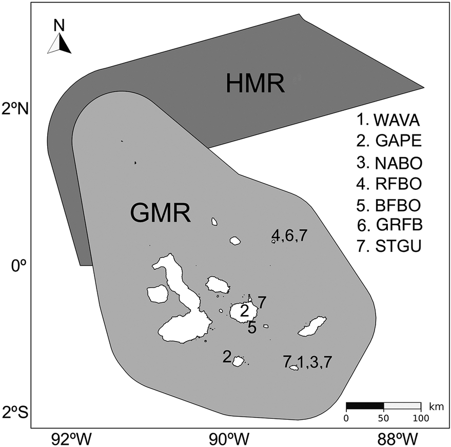
Ecuador has established two MPAs in the vicinity of its oceanic province Galápagos to protect marine habitats for native and migratory species (Jones Reference Jones2013; Reck Reference Reck, Denkinger and Vinueza2014; White et al. 2023). The Galápagos Marine Reserve (“GMR”), created in 1998, covers 143,000 km2 and encloses the terrestrial parts of the archipelago and its boundary waters (Figure 1). Its primary purpose is to protect marine biodiversity of the Galápagos archipelago from industrial fishing (Reck Reference Reck, Denkinger and Vinueza2014), although artisanal fishing (by local registered fishers only) is still permitted. More recently, in 2022, the 60,000 km2 Hermandad Marine Reserve (“HMR”) was created northeast of the GMR to protect the Galápagos-Cocos Swimway, a recognised marine corridor for sharks and other subsurface pelagic vertebrates (Hearn et al. Reference Hearn, Cárdenas, Allen, Zurita, Gabela-Flores and Peñaherrera-Palma2022), from extractive activities like industrial long-line and tuna purse-seine fishing (White et al. Reference White, Hearn, Moity, Ramírez-González, Saltzman, Viteri-Mejía, Enright and Barragán-Paladines2026) (Figure 1). Neither the GMR nor the HMR was explicitly designed based on seabird distributions.
Boundaries of Galápagos MPAs and breeding sites of study seabirds. Boundaries of the Galápagos Marine Reserve (GMR) and Hermandad Marine Reserve (HMR) in relation to the Galápagos Islands and the breeding sites of the birds featured in this study. Species names are abbreviated as follows: WAVA, Waved Albatross; GAPE, Galápagos Petrel; NABO, Nazca Booby; RFBO, Red-footed Booby; BFBO, Blue-footed Booby; GRFB, Great Frigatebird; STGU, Swallow-tailed Gull.

Figure 1. Long description
A geographical map with a North arrow in the top-left and a scale bar of 0 to 100 kilometers in the bottom-right. The map covers a region from 2 degrees North to 2 degrees South and 92 degrees West to 88 degrees West.
* In the North is a dark gray polygon labeled H M R, which extends from the Northwest toward the Northeast.
* Overlapping the southern portion of the H M R and extending South is a larger, light gray polygon labeled G M R. This area encompasses the Galápagos Islands, shown as white landmasses.
* Numerical labels indicating breeding sites are distributed across the islands within the G M R:
- In the Northeast of the G M R, a site is labeled 4, 6, 7.
- In the central region, sites are labeled 2, 5, and 7.
- In the South, a site is labeled 2.
- In the Southeast, a site is labeled 7, 1, 3, 7.
* A legend on the right side of the map lists the species corresponding to the numbers:
1. W A V A
2. G A P E
3. N A B O
4. R F B O
5. B F B O
6. G R F B
7. S T G U
Nevertheless, seabirds can benefit when MPAs encompass their key use areas (Ronconi et al. Reference Ronconi, Lascelles, Langham, Reid and Oro2012). Although species-specific studies exist (e.g. Waved Albatross tracking vs. GMR; Awkerman et al. Reference Awkerman, Fukuda, Higuchi and Anderson2005), no multi-species assessment has evaluated complete breeding-season space use across both MPAs. Elsewhere, seabird hotspots, identified through abundance and tracking data, have been used to designate new MPAs to support critical ecosystems (Carneiro et al. Reference Carneiro, Dias, Clark, Pearmain, Handley and Hodgson2024; Ronconi et al. Reference Ronconi, Lascelles, Langham, Reid and Oro2012). Using the BirdLife Seabird Tracking Database, large compilations of tracking data have directly underpinned the identification of sites such as the North Atlantic Current and Evlanov Sea basin MPA, a high-seas reserve established to safeguard key foraging areas for millions of seabirds (Carneiro et al. Reference Carneiro, Dias, Clark, Pearmain, Handley and Hodgson2024; Davies et al. Reference Davies, Carneiro, Campos, Hazin, Dunn, Gjerde, Johnson and Dias2021). A recent global analysis (Raynor et al. Reference Raynor, Orofino, Costello, McDonald, Mayorga and Sala2025) found that fully and highly protected MPAs are effective at preventing industrial fishing activity, which benefits seabirds.
Globally, seabird populations have declined by 70% since 1950 (Paleczny et al. Reference Paleczny, Hammill, Karpouzi and Pauly2015). One of the primary causes of adult mortality in seabird populations is bycatch from fishery interactions (Anderson et al. Reference Anderson, Small, Croxall, Dunn, Sullivan and Yates2011; Brothers et al. Reference Brothers, Duckworth, Safina and Gilman2010; Pott and Wiedenfeld Reference Pott and Wiedenfeld2017). Fishing activities occur within and especially adjacent to the Galápagos MPAs (Bucaram et al. Reference Bucaram, Hearn, Trujillo, Rentería, Bustamante, Morán, Reck and García2018; Hearn Reference Hearn2008; Jimenez-Uzcategui and Mangel Reference Jiménez-Uzcátegui, Mangel, Alfaro-Shigueto and Anderson2006; Martínez-Ortiz et al. Reference Martínez-Ortiz, Aires-da-Silva, Lennert-Cody and Maunder2015). Although local, artisanal fishers are permitted to operate under strict regulations within the GMR, illegal small-scale longlining and “ghost fishing” are increasing threats (Castrejón and Defeo Reference Castrejón and Defeo2024; Lively and Good Reference Lively, Good and Sheppard2019; Romero-Caicedo et al. Reference Romero-Caicedo, Buitron-Lopez, Tapia-Jaramillo, McKinley, Castro-Briones and Sevilla-Cedeño2025). Surveillance and experimental trials within the GMR have documented that longlines have caught protected seabird species incidentally, including the Critically Endangered Waved Albatross (de Souza Vianna et al. Reference de Souza Vianna, Jiménez-Uzcátegui, Salinas-de-León, Lopez and Barragán-Paladines2026). Within Ecuador’s Exclusive Economic Zone (“EEZ”), fishing activity outside the GMR is dominated by mainland-based Ecuadorian purse-seine and longline fleets, with some foreign-flagged vessels operating under access agreements (Bucaram et al. Reference Bucaram, Hearn, Trujillo, Rentería, Bustamante, Morán, Reck and García2018). Distant-water fleets from China, Taiwan, and other nations operate primarily in adjacent high-seas waters beyond the EEZ, approximately 160 nautical miles from the GMR boundary (Bucaram et al. Reference Bucaram, Hearn, Trujillo, Rentería, Bustamante, Morán, Reck and García2018). Together, these activities increase regional fishing pressure and raise concerns regarding fish-stock depletion, enforcement capacity, and illegal, unreported, and unregulated (IUU) fishing (Chinacalle-Martínez et al. Reference Chinacalle-Martínez, Hearn, Boerder, Murillo Posada, López-Macías and Peñaherrera-Palma2024). The high density of fishing vessels immediately outside the GMR borders, known as “fishing the line”, undermines the reserve’s protective intent and heightens the likelihood of bycatch (Boerder et al. Reference Boerder, Bryndum-Buchholz and Worm2017; Chinacalle-Martínez et al. Reference Chinacalle-Martínez, Hearn, Boerder, Murillo Posada, López-Macías and Peñaherrera-Palma2024). Similar pressures affect the HMR, located within Ecuador’s EEZ. Until its creation in 2022, the area was open to continental Ecuador’s industrial tuna fleet and long-line fishery (White et al. Reference White, Hearn, Moity, Ramírez-González, Saltzman, Viteri-Mejía, Enright and Barragán-Paladines2026). Under the current designation, the HMR is divided into an inner fully protected no-take zone and an outer “responsible fishing zone”, where longline fishing is prohibited and only selective fishing gear is permitted (Chinacalle-Martínez et al. Reference Chinacalle-Martínez, Hearn, Boerder, Murillo Posada, López-Macías and Peñaherrera-Palma2024).
Although MPAs may provide some at-sea protection for seabirds, seabird conservation requires at sea and terrestrial habitat protection. Seabirds spend much of their lives on the water, only returning to land to breed. During the breeding period, they are central-place foragers, feeding at sea but returning to land to incubate eggs or feed nestlings (Schreiber and Burger Reference Schreiber and Burger2001). Additionally, foraging-trip duration varies among species and breeding stages, and trips can be longer as chicks grow (Schreiber and Burger Reference Schreiber and Burger2001). In widely ranging species such as the Waved Albatross, Galápagos Petrel, and Great Frigatebird Fregata minor, foraging trips may last several days and include nocturnal flight or resting at sea (Awkerman et al. Reference Awkerman, Cruz, Proaño, Huyvaert, Jiménez-Uzcátegui and Baquero2014; Proaño et al. Reference Proaño, Cruz, Adams and Wikelski2026; Rattenborg et al. Reference Rattenborg, Voirin, Cruz, Tisdale, Dell’Omo, Lipp, Wikelski and Vyssotski2016). This reliance on land for breeding and on extensive marine areas for foraging means that seabirds integrate ecological signals across broad spatial scales, making their at-sea distributions highly relevant for marine conservation planning (Harding et al. Reference Harding, Piatt and Schmutz2007; Parsons et al. Reference Parsons, Mitchell, Butler, Ratcliffe, Frederiksen, Foster and Reid2008; Sydeman et al. Reference Sydeman, Thompson and Kitaysky2012). Seabird foraging zones provide a strong basis for identifying priority sites for their conservation (Donald et al. Reference Donald, Fishpool, Ajagbe, Bennun, Bunting and Burfield2019) and can play an important role in conservation strategies, including the delineation of new, or the expansion of, existing MPA boundaries (Burger and Shaffer Reference Burger and Shaffer2008; Carneiro et al. Reference Carneiro, Dias, Clark, Pearmain, Handley and Hodgson2024; Croxall et al. Reference Croxall, Butchart, Lascelles, Stattersfield, Sullivan, Symes and Taylor2012).
In this study, we compile tracking data for seven Galápagos seabird species from multiple research teams to assess the spatio-temporal overlap between their at-sea activity and the boundaries of the GMR and HMR MPAs. Our goal is to evaluate the extent to which each MPA spatially encompasses known breeding-season seabird foraging habitat. This assessment aims to inform marine conservation efforts in the Galápagos Islands, particularly for vulnerable seabird populations, and to provide spatially robust evidence to guide future expansions or new MPAs in the Galápagos vicinity.
Methods
Animal tracking data
This study analyses at-sea distributions of seven seabird species from three taxonomic orders that breed in the Galápagos Islands: Waved Albatross, Galápagos Petrel, Nazca Booby Sula granti, Red-footed Booby S. sula, Blue-footed Booby S. nebouxii, Great Frigatebird Fregata minor, and Swallow-tailed Gull Creagrus furcatus (Figure 1, Table 1). We compiled GPS and Argos tracking data shared by multiple research teams working with breeding seabirds in the Galápagos Islands; the data were deposited in Movebank (www.movebank.org) or shared directly with us (Kays et al. Reference Kays, Davidson, Berger, Bohrer, Fiedler and Flack2022). Although the research teams used slightly different attachment methods, in general, GPS loggers were taped to the rectrices or mid-dorsal feathers of breeding seabirds to record locations during foraging trips. These datasets represented contrasting breeding-season foraging strategies, ranging from relatively short trips within one daylight or nighttime period in Blue-footed Boobies and Swallow-tailed Gulls to multi-day trips in Nazca Boobies, Red-footed Boobies, Waved Albatrosses, Galápagos Petrels, and Great Frigatebirds, as described in previous tracking studies (Awkerman et al. Reference Awkerman, Cruz, Proaño, Huyvaert, Jiménez-Uzcátegui and Baquero2014; Howard et al. Reference Howard, Tompkins and Anderson2021; Mendez et al. Reference Mendez, Borsa, Cruz, de Grissac, Hennicke, Lallemand, Prudor and Weimerskirch2017; Proaño et al. Reference Proaño, Cruz, Adams and Wikelski2026). During multi-day trips, birds remain at-sea overnight either in flight or resting on water (e.g. Zavalaga et al. Reference Zavalaga, Emslie, Estela, Müller, Dell’Omo and Anderson2012) .
90% utilisation distribution areas and MPA overlap. Summary of the 90% utilisation distribution (UD) areas (km2) for each seabird species and the proportion of these areas found within the Galápagos Marine Reserve (“GMR”), within the Hermandad Marine Reserve (“HMR”), within both protected areas, and outside both protected areas (GMR+HMR)

Table 1. Long description
The table contains six columns: TAXON, 90 percent U D Area in km super 2, Within G M R, Within H M R, Within G M R plus H M R, and Outside G M R plus H M R.
* Phoebastria irrorata, Waved Albatross: 719,375 km super 2; 6 percent within G M R; 0 percent within H M R; 6 percent total within reserves; 95 percent outside.
* Pterodroma phaeopygia, Galápagos Petrel: 1,615,700 km super 2; 9 percent within G M R; 3 percent within H M R; 12 percent total within reserves; 89 percent outside.
* Sula granti, Nazca Booby: 216,793 km super 2; 11 percent within G M R; 0 percent within H M R; 11 percent total within reserves; 89 percent outside.
* Sula sula, Red-footed Booby: 82,423 km super 2; 21 percent within G M R; 2 percent within H M R; 23 percent total within reserves; 77 percent outside.
* Sula nebouxii, Blue-footed Booby: 792 km super 2; 100 percent within G M R; 0 percent within H M R; 100 percent total within reserves; 0 percent outside.
* Fregata minor, Great Frigatebird: 81,465 km super 2; 8 percent within G M R; 11 percent within H M R; 19 percent total within reserves; 81 percent outside.
* Creagrus furcatus, Swallow-tailed Gull: 8,992 km super 2; 95 percent within G M R; 0 percent within H M R; 95 percent total within reserves; 5 percent outside.
A full summary of species, breeding stage of tracked birds, data sources, and digital file details is provided in Supplementary material Tables S1 and S2. Our dataset for the seven species included 714 individual birds from breeding colonies on five islands (Santa Cruz, Española, Genovesa, South Plazas, Floreana) over a period of 13 years (2004–2017; Table 1). In total, our analysis used 1,208,559 GPS locations from complete foraging trips, covering an area of approximately 4,000,000 km2 (Supplementary material Figure S1).
Only complete foraging trips, with no data gaps, were included in the analysis (e.g. Conners et al. Reference Conners, Sisson, Agamboue, Atkinson, Baylis and Benson2022). We applied a 2-km mask around nesting colonies to remove locations recorded at the nest and during local non-foraging flight (e.g. for short baths; Conners et al. Reference Conners, Sisson, Agamboue, Atkinson, Baylis and Benson2022). The Galápagos Petrel Argos data were pre-processed using Argos filters available on Movebank (www.movebank.org) by the original data owner of “MPIAB Galápagos Petrel” (study 403960582). All other datasets were processed by us (applying the mask, removing incomplete trips) directly from the data on Movebank or shared with us.
Data analysis and utilisation distributions
Spatial analyses were conducted in R 4.4.2 (R Core Team 2024). All point and polygon data were projected from WGS84 to a planar coordinate reference system, UTM zone 16S, before spatial analyses. Data were converted between sf and sp objects when required to interface with adehabitatHR, using functions from the sf (Pebesma Reference Pebesma2018) and sp (Pebesma Reference Pebesma and Bivand2005) packages. Utilization distributions (UDs) were estimated using kernel density estimation (KDE), providing a probabilistic representation of seabird at-sea space use during the breeding period (Calenge Reference Calenge2006; Cleasby et al. Reference Cleasby, Owen, Wilson, Wakefield, O’Connell and Bolton2020). KDE is a non-parametric method for estimating the probability density function of a random variable, which in this context represents seabird spatial use at the species level. For each species, tracking data were pooled across individuals and used to estimate species-level UDs using the kernelUD function in the adehabitatHR package (Calenge Reference Calenge2006). The smoothing parameter was selected using Least Squares Cross-Validation (h = “LSCV”), a grid size of 250 m, and an extent of 1. Least Squares Cross-Validation is a data-driven method for selecting the smoothing parameter from the spatial distribution of tracking locations (Berg et al. Reference Berg, Linnebjerg, Taylor, Ismar-Rebitz, Bell, Gaskin, Åkesson and Rayner2019).
The 25%, 50%, and 90% UD contours were derived from the KDE surfaces using the getverticeshr function in adehabitatHR (Calenge Reference Calenge2006). These contours represent areas of increasing space-use probability for each species. The 90% UD was interpreted as the species’ breeding-season home range because it represents the main extent of space use while excluding outlier movements (Conners et al. Reference Conners, Sisson, Agamboue, Atkinson, Baylis and Benson2022). The 50% UD was interpreted as the core range (highest priority for protection) and the 25% UD as a high-use subset (Conners et al. Reference Conners, Sisson, Agamboue, Atkinson, Baylis and Benson2022; van der Wal and Rodgers Reference van der Wal and Rodgers2012). Core ranges derived from tracking data are widely used to identify the areas of most intensive use by individuals or colonies and thereby to delineate the most important foraging habitat for protection (Soanes et al. Reference Soanes, Frederiksen, Arnould, Dodd, Sumner and Green2013).
The resulting UDs were mapped and overlaid with the boundaries of the GMR and HMR to assess spatial overlap with these MPAs. Spatial overlap was calculated for each UD contour (25%, 50%, and 90%) and each MPA. Intersections between UD contours and MPA boundaries were calculated using the st_intersection function in sf, and polygon areas were estimated using st_area function in sf. These functions were used to estimate total area of each UD contour and the area of overlap between each UD contour and each MPA. Spatial overlap was then expressed as the percentage of each UD contour encompassed by the GMR, the HMR, and both MPAs combined.
Because several species undertake multi-day foraging trips during the breeding period, nighttime locations indicate periods when at least some of these species are known to remain at sea between daytime foraging bouts (Awkerman et al. Reference Awkerman, Cruz, Proaño, Huyvaert, Jiménez-Uzcátegui and Baquero2014; Proaño et al. Reference Proaño, Cruz, Adams and Wikelski2026; Rattenborg et al. Reference Rattenborg, Voirin, Cruz, Tisdale, Dell’Omo, Lipp, Wikelski and Vyssotski2016; Zavalaga et al. Reference Zavalaga, Emslie, Estela, Müller, Dell’Omo and Anderson2012). Any day/night contrast in MPA use (for example, diurnal foragers occupying areas outside the MPAs during the day and inside the MPAs at night) would be relevant to assessing conservation risk associated with MPA boundaries. Conversely, illegal intrusions into the GMR by fishing boats may occur more at night to avoid detection (Agnew et al. Reference Agnew, Pearce, Pramod, Peatman, Watson, Beddington and Pitcher2009), increasing exposure to the fishery within the MPA at night. To assess whether MPA use differed between diel periods, GPS locations were classified as daytime or nighttime. Sunrise and sunset times were estimated using the suncalc package, and these times were used to classify each GPS location by daytime or nighttime period (Benoit and Elmarhraoui Reference Benoit and Elmarhraoui2023). Each GPS location was then assigned to one of four mutually exclusive categories: inside an MPA during daytime, inside an MPA during nighttime, outside an MPA during daytime, or outside an MPA during nighttime. Proportions were calculated relative to the total number of GPS locations for each species; therefore, the four categories summed to 1 for each species. These calculations were conducted using functions from the dplyr and lubridate packages (Grolemund and Wickham Reference Grolemund and Wickham2011; Wickham et al. Reference Wickham, François, Henry, Müller and Vaughan2023).
MPA boundary polygons were downloaded from the Charles Darwin Foundation Research Hub/Data Zone, and polygon layers for the Galápagos Islands and the Americas were downloaded from ArcGIS Hub. Maps of UD contours, MPA boundaries, and land areas were produced using ggplot2 (Wickham Reference Wickham2009).
Results
Home range size (90% UD) varied among species (Table 1). The Galápagos Petrel exhibited the largest home range, covering 1.6 million km², whereas the Blue-footed Booby had the smallest, at 792 km². Overlap between MPAs and the 25%, 50% and 90% UDs varied widely among species. Within the GMR, the Blue-footed Booby and Swallow-tailed Gull showed the highest overlap, with 100% and 95% of their home range inside the reserve, respectively, whereas the Waved Albatross had minimal overlap (6%). The remaining species had less than 20% overlap of their respective home ranges with the GMR. Despite the Galápagos Petrel utilising 98% of the GMR, this MPA covers only 9% of its extensive home range (Table 1, Figure 1). The HMR intersected the home ranges of Galápagos Petrels (3%), Great Frigatebirds (11%), and Red-footed Boobies (2%), to a minimal degree in each case.
Five of the seven species had ≤43% of their home range encompassed by the two Galápagos MPAs combined (Supplementary material Table S3). Blue-Footed Boobies and Swallow-tailed Gulls showed the greatest overlap, restricted almost entirely to the GMR only (Figure 2). In contrast, Waved Albatrosses had no overlap of its core range (50% UD) with either Galápagos MPA, and Great Frigatebirds had minimal overlap of their core range (50% UD) with the MPAs. Results for the 25% UDs were consistent with those for the 50% UDs, indicating that areas of high intensity use were also poorly represented for most species by the MPAs (Figure 2; Supplementary material Table S3). Overall, our results indicate that the oceanic region east of Galápagos constitutes the most extensively used habitat not encompassed within the current boundaries of the GMR and HMR.
Utilisation distributions of seven breeding seabird species in the Galápagos Islands. Utilization distributions (red = 25%, orange = 50%, yellow = 90%) of seven species of seabirds breeding in the Galápagos Islands: A. Nazca Booby Sula granti; B. Red-footed Booby S. sula; C. Blue-footed Booby S. nebouxii; D. Waved Albatross Phoebastria irrorata; E. Galápagos Petrel Pterodroma phaeopygia; F. Great Frigatebird Fregata minor; G. Swallow-tailed Gull Creagrus furcatus. Black arrows indicate colony site where birds were tagged. Land mass to the east in panels (d) and (e) is the South American continent.
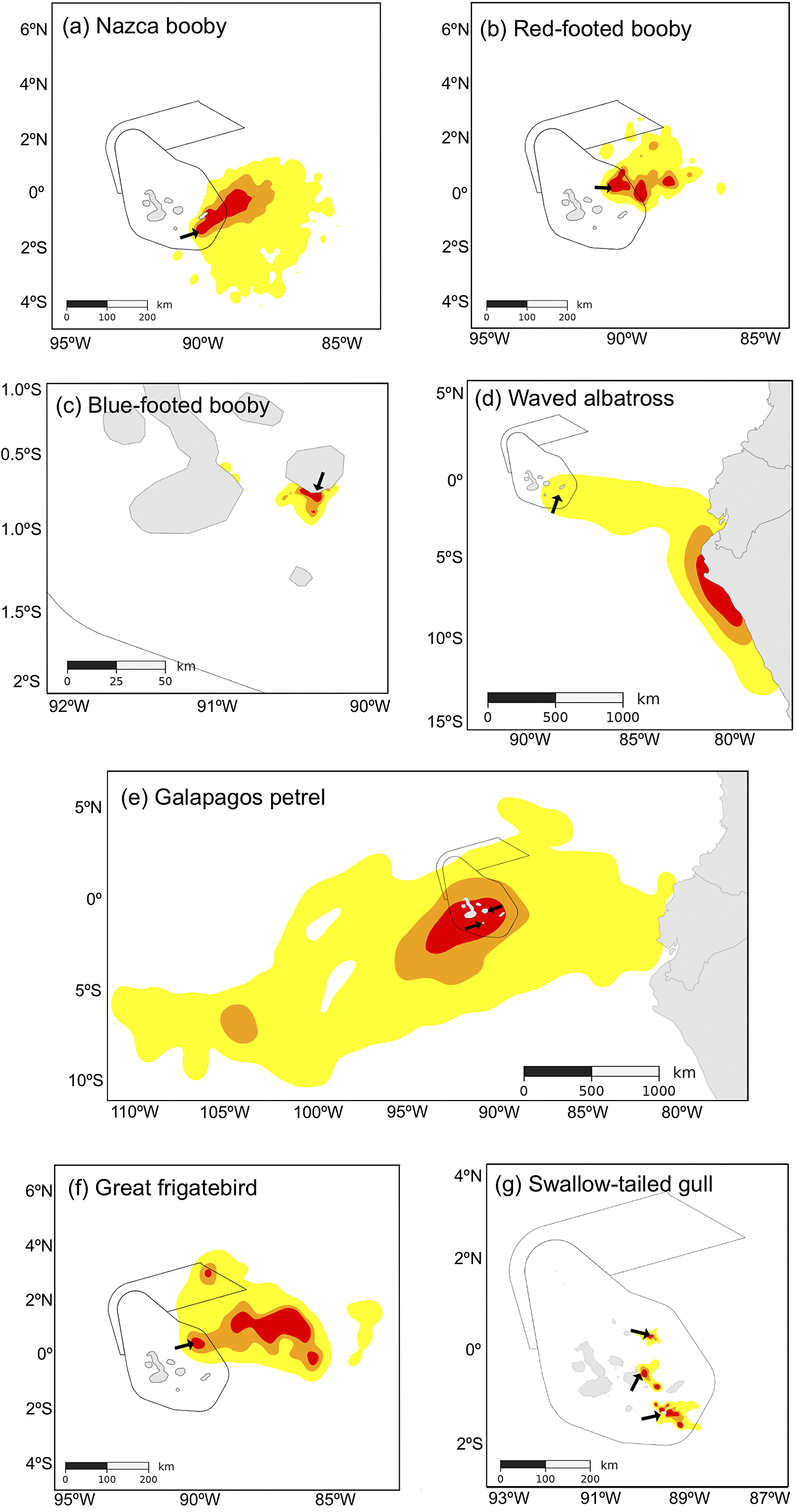
Figure 2. Long description
A series of seven panels labeled a through g, each showing a map with colored heat zones representing utilization distributions: red for 25 percent, orange for 50 percent, and yellow for 90 percent. Black arrows indicate tagging colonies.
* Panel a. Nazca booby: Distribution extends East and Southeast from the central islands.
* Panel b. Red-footed booby: Distribution is concentrated Northeast of the central islands.
* Panel c. Blue-footed booby: A localized distribution concentrated around the easternmost islands.
* Panel d. Waved albatross: A large distribution extending East from the islands to the South American coast, then South along the Peruvian shoreline.
* Panel e. Galapagos petrel: The largest distribution, spanning from 110 degrees West to the South American coast, centered around the islands.
* Panel f. Great frigatebird: Distribution extends East and Northeast from the islands with multiple core red zones.
* Panel g. Swallow-tailed gull: Three distinct, small localized distributions around the central and eastern islands.
Panels d and e include the South American landmass on the East. Scale bars in kilometers vary by panel, ranging from 50 kilometers in panel c to 1000 kilometers in panels d and e.
Diel patterns in the distribution of GPS locations varied among species (Figure 3). Overall, GPS locations were distributed relatively evenly between day and night, indicating that many birds remained at sea overnight during multi-day foraging trips, as observed in previous studies of Galápagos seabirds (Awkerman et al. Reference Awkerman, Cruz, Proaño, Huyvaert, Jiménez-Uzcátegui and Baquero2014; Mendez et al. Reference Mendez, Borsa, Cruz, de Grissac, Hennicke, Lallemand, Prudor and Weimerskirch2017; Proaño et al. Reference Proaño, Cruz, Adams and Wikelski2026; Rattenborg et al. Reference Rattenborg, Voirin, Cruz, Tisdale, Dell’Omo, Lipp, Wikelski and Vyssotski2016; Zavalaga et al. Reference Zavalaga, Emslie, Estela, Müller, Dell’Omo and Anderson2012). During nighttime, bird may be resting on the water, flying (e.g. Great Frigatebirds), or foraging from the water’s surface. Only two species showed clear day/night differences in MPA use: Swallow-tailed Gulls showed the strongest contrast, with a higher proportion of nighttime locations occurring inside MPAs than daytime locations, and Red-footed Boobies showed a similar but weaker pattern. The remaining species showed weak or no diel differences in the proportion of locations occurring inside MPAs.
Proportion of daytime and nighttime GPS locations inside and outside Galápagos MPAs by species. Proportion of GPS locations assigned to four categories: inside MPAs during daytime (light grey), inside MPAs during nighttime (grey), outside MPAs during daytime (dark grey) and outside MPAs during nighttime (black). Error bars show 95% Wilson binomial confidence intervals for location counts. Where proportions within a species do not sum to 1 it is due to rounding error.
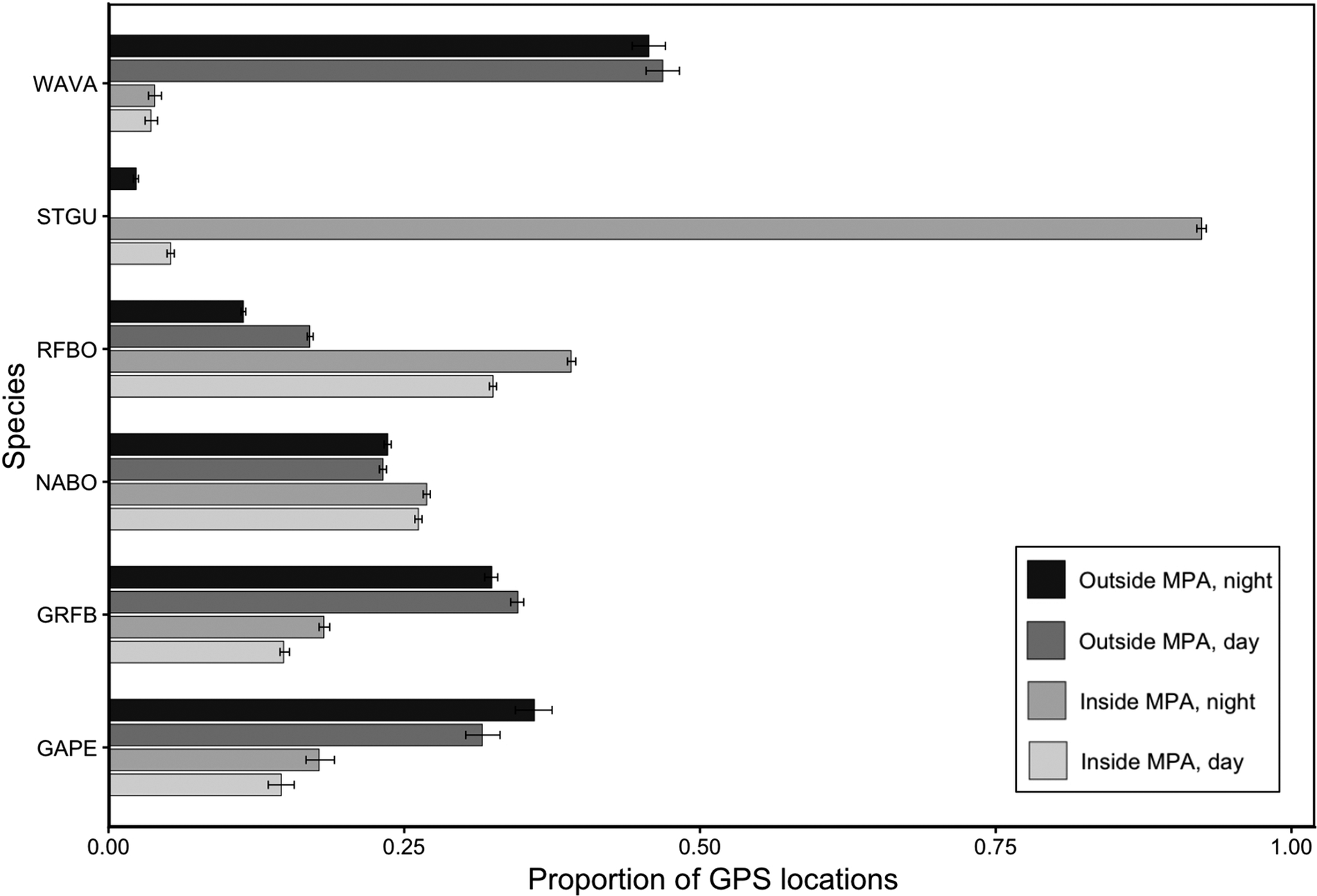
Figure 3. Long description
The horizontal axis is labeled Proportion of G P S locations, ranging from 0.00 to 1.00. The vertical axis lists six species from top to bottom: W A V A, S T G U, R F B O, N A B O, G R F B, and G A P E. Each species has a cluster of four bars. From top to bottom within each cluster, the bars represent: Outside M P A night (black), Outside M P A day (dark grey), Inside M P A night (grey), and Inside M P A day (light grey).
* W A V A: Outside night and day bars are longest, both near 0.45. Inside bars are very short, below 0.05.
* S T G U: Inside M P A night is the dominant bar, reaching approximately 0.92. All other bars are below 0.05.
* R F B O: Inside M P A night is longest at 0.40, followed by Inside M P A day at 0.32. Outside bars are shorter, between 0.10 and 0.18.
* N A B O: All four bars are relatively similar, ranging between 0.22 and 0.27.
* G R F B: Outside M P A day and night are longest, between 0.32 and 0.35. Inside bars are shorter, between 0.15 and 0.18.
* G A P E: Outside M P A night is longest at 0.36, followed by Outside M P A day at 0.31. Inside bars are shorter, between 0.14 and 0.18.
Small horizontal error bars are present at the end of every bar, representing 95 percent Wilson binomial confidence intervals.
Discussion
The overlap between the Galápagos MPAs (GMR and HMR) and the UDs of seven seabird species highlights both the contribution and limitations of these marine reserves in covering breeding-season space use. Only two species, the Blue-footed Booby and the Swallow-tailed Gull, had complete or near-complete coverage of their 90%, 50%, and 25% UDs by the GMR. This is consistent with the Blue-footed Booby’s near-shore and limited pelagic movements (Figure 2c; Anchundia et al. Reference Anchundia, Anderson and Anderson2017; Anderson and Ricklefs Reference Anderson and Ricklefs1987), which probably characterize much of the Galápagos population. To support this, GPS loggers were deployed on individuals at colonies in northern Isabela (Punta Vicente Roca), northwest Fernandina (Cabo Douglas), and Daphne Major in the central archipelago. These incomplete tracks did not meet our inclusion criterion (complete trips) and therefore are not part of the formal analysis in this study. Nonetheless, they suggest that the species forages not far from the coast, with movements between islands, and within the GMR (Anchundia et al. Reference Anchundia, Anderson and Anderson2017). Similarly, Swallow-tailed Gulls tracked from three islands remained largely within the GMR during breeding, with only 5% of the species’ home range outside of the reserve (Cruz et al. Reference Cruz, Halpin, Proaño, Anderson and Wikelski2025). Although both small-range species were tracked from a subset of their Galápagos colonies, previous studies of their ecology and at-sea movements suggest that most individuals forage within the GMR during breeding (for Swallow-tailed Gulls, see Cruz et al. Reference Cruz, Halpin, Proaño, Anderson and Wikelski2025; Harris Reference Harris1970). In contrast, overlap between the Galápagos MPAs and the other five species UDs is limited. Among sulids, Nazca and Red-footed Boobies show intermediate overlaps: 30% and 38% of their core range (50% UDs) are within the GMR, respectively, and coverage by the HMR is minimal (Red-footed Booby overlap is 2% of their home range). These values reflect wider breeding at-sea distributions than Blue-footed Boobies.
The Galápagos Petrel had the largest home range among the species examined, and although 42% of its core range (50% UD) overlapped with the GMR, only 9% of its home range was encompassed by the Galápagos MPAs. By contrast, 42% of its core range (50% UD) overlapped with the GMR, indicating moderate coverage. The Waved Albatross was the least protected by the GMR, with only 6% of its home range (90% UD) overlapping the reserve. Its core range (50% UD) has 0% overlap with the Galápagos MPAs and lies entirely along the South American mainland coast. This IUCN Critically Endangered species faces significant challenges in coastal Ecuador and Perú, its primary foraging zones (Awkerman et al. Reference Awkerman, Fukuda, Higuchi and Anderson2005, Reference Awkerman, Cruz, Proaño, Huyvaert, Jiménez-Uzcátegui and Baquero2014). The Great Frigatebird was the only species whose core range (50% UD) overlapped the HMR. However, protection remained limited: only a fraction of both its core and home range fell within either the GMR or HMR. This indicates that, although the species uses both MPAs, most of its breeding-season distribution occurs outside existing protected boundaries.
Overall, the Galápagos MPAs provide poor coverage for most of the seabird species examined. The recent establishment of the HMR had added little direct protection for these species, although indirect effects are conceivable; these include enhancing the populations of prey, or of subsurface predators that facilitate availability of prey (Ballance Reference Ballance2007; Spear et al. Reference Spear, Ainley and Walker2007), that could move into the foraging range of the focal seabird species. In contrast, the GMR provides high spatial overlap during the breeding season for seabirds exploiting near-coastal or coastal habitats and those with relatively modest pelagic distributions.
Although this study compiles all available public tracking data to create the most comprehensive seabird dataset for the Galápagos to date, fewer than half of the archipelago’s seabird species are represented (in most cases because no tracking study has been conducted). Nevertheless, some generalizations can be made. Three of these species (Galápagos Penguin Spheniscus mendiculus, Flightless Cormorant Nannopterum harrisi, and Lava Gull Leucophaeus fuliginosus) have at-sea movements that typically restrict them to the GMR (Grant et al. Reference Grant, Estes and Estes2015; Hayward et al. Reference Hayward, Megna, Payne, Velastegui Chávez and Henson2013; Snow Reference Snow1966; Vargas et al. Reference Vargas, Lacy, Johnson, Steinfurth, Crawford, Boersma and Macdonald2007; Vargas et al. Reference Vargas, Lougheed and Snell2005). Some others probably move regularly beyond the Galápagos MPA boundaries, given their pelagic foraging in studies outside the Galápagos Islands (Magnificent Frigatebird F. magnificens (Austin et al. Reference Austin, De Pascalis, Arnould, Haakonsson, Votier, Ebanks-Petrie, Austin, Morgan, Bennett and Green2019; Zaluski et al. Reference Zaluski, Soanes, Bright, George, Jodice, Meyer, Woodfield-Pascoe and Green2019), Red-billed Tropicbird Phaethon aethereus (Madden et al. Reference Madden, Satgé, Wilkinson and Jodice2022), Galápagos Shearwater Puffinus subalaris (Austin et al. Reference Austin, Bretagnolle and Pasquet2004), and Sooty Tern Onychoprion fuscatus (Neumann et al. Reference Neumann, Larose, Brodin and Feare2018), and the storm petrels Hydrobates castro, H. tethys, and Oceanites gracilis (Harris Reference Harris1969). Additionally, our movement data cover only some colonies of the seven study species; tracking Nazca Boobies on Genovesa, Darwin, and Wolf, and Red-footed Boobies on Darwin and Wolf, could reveal different patterns, as large breeding populations on these northern islands may use the nearby HMR more than those included in this study.
Our findings align with recent studies highlighting the mismatch between the movement patterns of highly mobile marine megafauna and the spatial boundaries of MPAs, suggesting that current conservation strategies may be insufficient for these Galápagos species (Conners et al. Reference Conners, Sisson, Agamboue, Atkinson, Baylis and Benson2022). These findings should be interpreted from a seabird representation perspective, recognizing that the GMR and HMR were established with broader objectives. Low UD–MPA overlap does not imply a failure of the MPAs’ goals; rather, it indicates gaps in the coverage of seabird breeding season space use. These gaps may be particularly relevant where seabird distributions outside MPAs overlap with fishing activity. Several of the species examined here have been recorded around the Ecuadorian offshore longline fleet. Recent observer data from Ecuadorian longline vessels recorded 25 seabird species around fishing operations between 2019 and 2023, including Swallow-tailed Gulls, Waved Albatrosses, Galápagos Petrels, Nazca and Red-footed Boobies, and frigatebirds (Soriano et al. Reference Soriano, Duque, Herrera and Zambrano2025).
Furthermore, MPA effectiveness to protect species can shift over time as species shift their foraging ranges in response to climatic events (e.g. El Niño) and climate-driven dietary changes (Gilmour et al. Reference Gilmour, Adams, Block, Caselle, Friedlander and Game2022). For example, following the 1997–98 El Niño event, Nazca Boobies in Galápagos shifted their diet from sardines (Sardinops sagax) — previously a key food source— to less nutritious flying fish (Exocetidae), due to sardine scarcity (Tompkins et al. Reference Tompkins, Townsend and Anderson2017). This shift, apparently driven by ocean warming, has led to lower foraging success, reduced breeding success, and a forecasted population decline; see also Anchundia et al. Reference Anchundia, Huyvaert and Anderson2014). Relevant to this study, the foraging ranges of breeding Nazca Boobies from Española changed from mostly within the GMR’s boundaries in the 1980s (Anderson and Ricklefs Reference Anderson and Ricklefs1987) to largely outside the GMR (Figure 2a; McKee et al. Reference McKee, Tompkins, Estela and Anderson2023), illustrating how environmental variability can alter the effectiveness of static marine protection over time.
Diel patterns in MPA use were generally weak, suggesting that day/night differences had limited influence on the interpretation of spatial overlap between seabird distributions and the MPAs. Red-footed Boobies showed a possible weak diel pattern, with a higher proportion of daytime GPS locations outside the MPAs and a higher proportion of nighttime locations inside the MPAs (Figure 3). Red-footed Boobies from Galápagos undertake some of the longest foraging trips recorded for this widespread species, often spanning multiple days and nights (Mendez et al. Reference Mendez, Borsa, Cruz, de Grissac, Hennicke, Lallemand, Prudor and Weimerskirch2017). Because this species is usually considered a diurnal forager (Weimerskirch et al. Reference Weimerskirch, Le Corre, Jaquemet and Marsac2005), nighttime locations inside MPAs probably do not represent active pursuit of prey. Instead, they may reflect birds remaining at sea overnight, resting on the water before resuming daytime foraging or commuting. Swallow-tailed Gulls showed the clearest diel contrast, consistent with their nocturnal foraging ecology (Figure 3; Cruz et al. Reference Cruz, Hooten, Huyvaert, Proaño, Anderson, Afanasyev and Wikelski2013; Cruz et al. Reference Cruz, Halpin, Proaño, Anderson and Wikelski2025), whereas the remaining species showed weak or no day/night differences in the proportion of GPS locations occurring inside MPAs. This likely reflects the prevalence of multi-day foraging trips during which birds remain at sea overnight. Overall, diel contrasts in MPA use were minor and did not substantially change the broader conclusion that spatial overlap with existing MPAs was strongly species-specific.
Our Waved Albatross dataset does not include tracking data from the early brooding period, when adults conduct frequent, short foraging trips within the GMR to provision small chicks. Previous research has demonstrated that during this stage, Waved Albatrosses rely more heavily on the waters within the GMR (Awkerman et al. Reference Awkerman, Fukuda, Higuchi and Anderson2005). The absence of this period in our dataset may result in an underestimation of the overlap with the GMR and this species. This highlights the importance of accounting for temporal complexity across the breeding cycle when assessing MPA effectiveness: foraging distributions may vary markedly across breeding phases.
Continuing with this theme, this study is based on data collected during the breeding season from breeding-age adults of seven seabird species, several of which are known to migrate or disperse extensively once they cease (seasonally) being central-place foragers. For example, Waved Albatrosses are rarely observed around the Galápagos Islands during the three-month nonbreeding period (Harris Reference Harris1973), and Swallow-tailed Gulls leave these MPAs between breeding attempts (Harris Reference Harris1970). The sub-adult stage will be under-protected for species, such as Nazca Boobies, that disperse outside these MPAs for the several years between independence from their parents and return to the breeding colony as adults (Huyvaert and Anderson Reference Huyvaert and Anderson2004; Maness and Anderson Reference Maness and Anderson2008). Even among adults, age and sex may affect the areas used outside the MPAs, as in the case of Nazca Booby adults breeding on Española: young adult males leave the GMR to the southeast more than middle-aged and older adults do (McKee et al. Reference McKee, Tompkins, Estela and Anderson2023). In the East Antarctic shows that MPAs delineated around breeding-season distributions fail to include critical non-breeding moulting and wintering areas of Adélie Penguins, emphasizing the need for MPAs that incorporate full annual spatial use and migratory connectivity (Zajková et al. Reference Zajková, Kato, Raclot, Angelier, Thiebot, Takahashi and Ropert-Coudert2026). Furthermore, for species whose annual movements extend beyond MPA boundaries and into international waters, the Biodiversity Beyond National Jurisdiction Agreement (BBNJ), which entered into force in January 2026, may provide a future mechanism for developing area-based management tools, including MPAs, in high-seas areas used by Galápagos seabirds (Wang Reference Wang2025). These considerations emphasize the difficulty faced by designers of MPAs attempting to provide complete protection across all life stages.
Conclusion
Our analysis finds that MPAs in the Galápagos Islands provide at least moderate protection for most resident breeding seabird species. While the GMR encompasses the breeding movements of Blue-footed Boobies and Swallow-tailed Gulls at the studied colonies, it offers insufficient protection for species such as the Great Frigatebird and the Critically Endangered Waved Albatross. The HMR provides minimal or no coverage for the species examined, with only the Great Frigatebird entering it to a meaningful degree. The lack of tracking data from the northernmost islands limits our understanding of seabird movements in that region, which may be important for assessing the HMR’s effectiveness. Many seabirds disperse far beyond the MPAs outside the breeding season, and sub-adult stages are also left unprotected. To enhance conservation strategies for these wide-ranging taxa, it will be important to expand MPA boundaries, incorporate seasonal and sub-colony-specific data, and consider the full annual cycles of the species.
Supplementary material
The supplementary material for this article can be found at http://doi.org/10.1017/S0959270926100719.
Acknowledgements
We thank the Galápagos National Park Directorate for permission to conduct research within the park under permit PC-15-07, PC-50-10, and the Charles Darwin Research Station for logistical support. This publication is contribution number 2742 of the Charles Darwin Foundation for the Galápagos Islands. All fieldwork for Nazca and Blue-footed Boobies and Waved Albatrosses complied with Animal Care and Use Protocol, approved by Wake Forest University.



 Open access

