INTRODUCTION
The site of Izapa is most famous for its stone stelae and altars. As Clark and Lowe (Reference Clark, Lowe, Lowe, Ekholm and Clark2013:69) recently put it, “no contemporaneous city had as many stone monuments which displayed such a variety of mythic and narrative scenes” (see also Clark and Pye Reference Clark, Pye, Clark and Pye2000; Love Reference Love2007, Reference Love, Love and Kaplan2011). The corpus of carved monuments at Izapa is extensive (Clark and Moreno Reference Clark, Moreno, Lowe and Pye2007; Guernsey Reference Guernsey2006) and their meaning is discussed in papers of this Special Section written by Guernsey (Reference Guernsey2018) and Strauss (Reference Strauss2018). Izapa was first tested by Drucker (Reference Drucker1948) and then excavations by the New World Archaeological Foundation (NWAF) in the 1960s focused primarily on documenting the site's sculptures (Lowe et al. Reference Lowe, Lee and Espinoza1982). After four seasons of work, Lowe (Lowe et al. Reference Lowe, Lee and Espinoza1982:23–27) attributed Izapa's stelae to the Late Formative Guillén phase that is now dated to 300–100 cal b.c. (Lowe et al. Reference Lowe, Ekholm and Clark2013:Figure 2). Additional work by the Instituto Nacional de Antropología e Historia (INAH) in the 1990s focused on better defining a reservoir and hydraulic systems at the site (Gómez Rueda Reference Gómez Rueda1995, Reference Gómez Rueda1996). Recent efforts to reanalyze radiocarbon dates and ceramic attributes posit that so-called “Izapa style” sculpture at other sites, such as Kaminaljuyu and Takalik Abaj, were erected after a.d. 100 (Inomata et al. Reference Inomata, Ortiz, Arroyo and Robinson2014; but see Love Reference Love2018). These issues are not directly addressed in this paper. Styles of public art were borrowed and the convention of pairing stelae with altars was evidently adopted at sites across Mesoamerica but this could have occurred decades or centuries after kings commissioned those at Izapa. Rather than focus on artistic conventions for political aggrandizement, we investigate the political economy that allowed for the consolidation of power by Izapa's ruling elite. In this paper, we present new excavation results, site formation patterns, and evidence of domestic and public activities from different areas of Izapa during the second part of Middle Formative period.
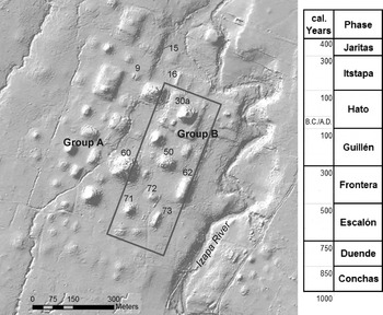
The Izapa Regional Settlement Project (IRSP) has recently established regional patterns using lidar (light detection and ranging) and pedestrian survey data to reconstruct the political organization of Izapa and surrounding areas for the first time. By the late Middle Formative Escalón and Frontera phases (750–300 cal b.c.), Izapa was the capital of a regionally organized polity consisting of dozens of monumental centers that employed the same architectural forms and site planning principles forming a four-tiered administrative hierarchy (Rosenswig Reference Rosenswig2016; Rosenswig and López-Torrijos Reference Rosenswig and López-Torrijos2018). The initial architectural layout of Izapa and all lower-order centers in the polity followed the same plan (Blake et al. Reference Blake, Rosenswig and Waber2015; Rosenswig et al. Reference Rosenswig, López-Torrijos and Antonelli2015b) and is somewhat related to what Clark and Hansen (Reference Clark, Hansen, Inomata and Houston2001) have called the Chiapas Middle Formative pattern (see also Lowe Reference Lowe and Adams1977). Sites built according to the Izapa pattern had mounds forming multiple plazas arranged in a roughly north-south alignment with a large pyramid at each site's north end sitting atop a platform and an E-Group at each site's southern end. At Izapa, the southern E-Group was only recently recognized with the help of lidar technology (Rosenswig et al. Reference Rosenswig, López-Torrijos, Antonelli and Mendelsohn2013). Figure 1 presents a hillshaded, digital elevation model (DEM) image based on these lidar data, which depict the mounds that form lower Izapa, the Formative period center of the site.
Hillshaded digital elevation model (DEM) of lower Izapa and chronology of Middle, Late, and Terminal Formative period phases. Rectangular box indicates location of initial Middle Formative monumental construction at the site. Map by Rosenswig.

The neighboring kingdoms of Takalik Abaj and El Ujuxte also each employed their own distinct conventions for the arrangement of monumental architecture at capitals and secondary centers (Love Reference Love, Love and Kaplan2011). In addition to being the capital of a polity that shared a distinctive architectural tradition, the residents of all centers within the Izapa kingdom employed ceramic vessels with decorations, forms, and styles that resist easy crossties with those used by neighboring peoples. Even those peoples inhabiting the Mazatán zone approximately 40 kilometers to the northwest or El Ujuxte approximately 40 kilometers to the southeast used quite different ceramic assemblages (Clark Reference Clark, Traxler and Sharer2016:202; Clark and Lowe Reference Clark, Lowe, Lowe, Ekholm and Clark2013:79). The fact that distinct ceramic assemblages are documented at all monumental centers (Rosenswig et al. Reference Rosenswig, Mendelsohn, Antonelli, Lieske and Córtes2014) and that these were different from their immediate neighbors allows us to infer that Izapa was a self-contained political (and quite possibly ethnic) kingdom.
The descriptor “kingdom” is used here to describe a hierarchical polity ruled by a king. This label avoids the sterile typological issue of whether Izapa was a complex chiefdom or an archaic state. Clark (Reference Clark1997) defines a kingdom in this way and uses the term to describe many of the Middle Formative polities in Chiapas, including Izapa (Clark Reference Clark, Traxler and Sharer2016). Elsewhere, Rosenswig (Reference Rosenswig2012) argues that economic exploitation was first clearly identifiable in the Soconusco during the Conchas phase, after 1000 cal b.c. Exploitation of the labor of the masses to support a small elite is the most fundamental qualitative transformation of social organization to have ever befallen the human species. Cross-culturally, ideological justification (such as divine kingship) reinforces through political and religious means this novel establishment of economic inequality (Rosenswig Reference Rosenswig, Rosenswig and Cunningham2017). Izapa was a kingdom because it had a series of kings that ruled over a region that is estimated to be 450 km2 based on a system of dozens of hierarchically organized monumental centers (Rosenswig and López-Torrijos Reference Rosenswig and López-Torrijos2018). The preceding Conchas-phase La Blanca polity (Love Reference Love2002) might have also been a kingdom, but there are no preserved depictions of kings. Rather than exploring “what” Izapa was, in a typological sense, the IRSP endeavors to reconstruct how the political economy of the early kingdom was organized.
This paper presents new results from recent excavations carried out at Izapa. The objective of our 2012 field season was to locate early midden deposits below the site's enormous mounds, collect artifacts from these secondary contexts, and recover datable materials. We begin by reviewing basic patterns of Formative period architectural construction and urban expansion documented at Izapa by the NWAF. Next, the 2012 excavations are reported from the north and south ends of Izapa's Group B (Figure 1). Ten new AMS radiocarbon dates are presented along with descriptions of the Middle and Late Formative contexts from which they were recovered. Ceramic density statistics are presented from different depositional contexts that help to reconstruct Middle Formative middens and compare them to Late and Terminal Formative construction fill as well as off-mound contexts that were mined for construction material. Finally, formal and metric ceramic patterns from late Middle Formative period midden deposits are discussed. The proportion of dishes to jars helps identify domestic from more publically oriented areas of the site at this time. The distribution of rim diameters are compared from fancy and plain dishes that differentiate between domestic and more publically oriented practices at the site center. Such basic archaeological data have thus far been missing from interpretations of Izapa and are crucial if we are to understand the political and economic organization of the kingdom's capital city.
NWAF EXCAVATIONS (1961–1965): MIDDLE AND LATE FORMATIVE PERIOD RESULTS
The NWAF excavations concentrated on dating Izapa's construction history and associated stone monuments. Results from four seasons of excavation demonstrated that the large mounds in lower Izapa reached their greatest height and were distributed over the largest area by the Late Formative Guillén phase (Clark and Lowe Reference Clark, Lowe, Lowe, Ekholm and Clark2013:78–79; Lowe et al. Reference Lowe, Lee and Espinoza1982:133). The first pyramid built at Izapa, however, is within Mound 30a and, by the end of the Duende phase (750 cal b.c.), measured 12 m in height (Ekholm Reference Ekholm1969:67–86; Lowe et al. Reference Lowe, Lee and Espinoza1982:123–127). During the Frontera phase, Mound 30a reached its current height of 16 m above a large, artificially constructed platform. The mounds that form Group B contain Early and early Middle Formative period ceramic sherds in their fill, which indicates the presence of an earlier community that preceded monumental construction at the site. Escalón- and Frontera-phase pottery is documented below most of the mounds in lower Izapa and Miscellaneous Monument 2 (“El León”), the earliest sculpture documented at the site, is associated with Frontera-phase ceramics (Navarrete Reference Navarrete2013:19–31). During late Middle Formative times, Izapa was a large settlement with monumental architecture defining plazas along the west bank of the Izapa River. During the subsequent Guillén phase, the plazas around Group H and G had been scraped clean of any traces of earlier occupation, presumably to serve as fill for the newly constructed mounds (Clark and Lowe Reference Clark, Lowe, Lowe, Ekholm and Clark2013:76–77), and lower Izapa expanded west to assume its current extents (Figure 1).
The NWAF excavation campaign, from 1961 to 1965, was a formidable undertaking and established the site as an important early Mesoamerican city (Lowe et al. Reference Lowe, Lee and Espinoza1982). Recently, efforts by John Clark have resulted in the publication of the Escalón-, Frontera-, and Guillén-phase ceramic types (Lowe et al. Reference Lowe, Ekholm and Clark2013) and a more complete description of NWAF excavation results from lower Izapa (Clark Reference Clark, Clark and Lee2013; Clark and Lee Reference Clark and Lee2013; Navarrete Reference Navarrete2013). These 2013 publications bring the Formative period results of the NWAF excavations to the maximum extent of their publication. The NWAF excavations have a number of weaknesses. For one thing, none of the matrix from excavated deposits was screened. This makes quantitative comparisons of ceramics and other artifacts impossible. A second problem is with the radiocarbon dating of the 1960s which resulted in very large error ranges (i.e., 2-sigma ranges of up to 470 years). Twelve of these dates were associated with Middle and Late Formative period deposits (Lowe et al. Reference Lowe, Lee and Espinoza1982:116–117). Such deficiencies would be true of any contemporary archaeological excavations and we raise these points as fact not in criticism. A further deficiency is that, while admirable, Clark brought to fruition the final 2013 publications many decades after others undertook the work and he had to contend with incomplete records and partial artifact samples. In spite of these shortcomings, the NWAF work at Izapa lay a solid base upon which even minor new excavations can contribute to an understanding of this large, long-lasting, and complex site.
IRSP EXCAVATIONS
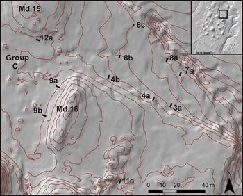
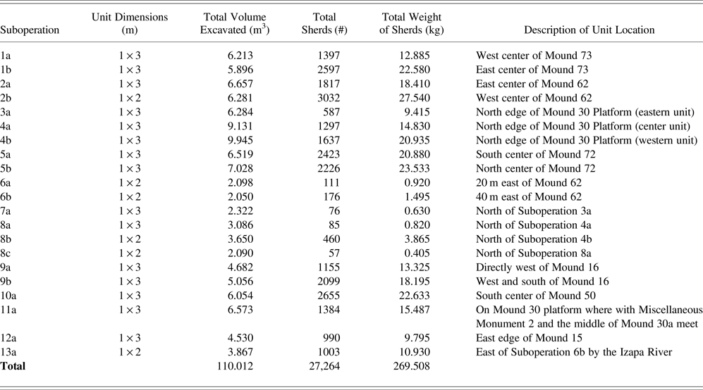
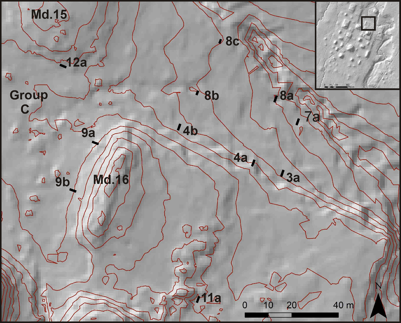
The IRSP excavations at Izapa focused on areas north and south of the mounds that form Group B, as this is where the ancient city originated. We excavated 21 units during a four-week period in July and August of 2012 (Table 1). We documented Late Formative construction fill at five mounds (Mounds 15, 50, 62, 72, and 73) and encountered Middle Formative midden remains preserved under two of them (Mounds 62 and 73) from areas south of Group B (Rosenswig et al. Reference Rosenswig, Mendelsohn, Antonelli, Lieske and Córtes2014). In addition, five units were excavated in the platform on which Mound 30a sits, three along the north edge (Suboperations 3a, 4a, and 4b) and two along the north part of the west edge (Suboperations 9a and 9b; see Figure 2). Together, these excavations documented three episodes of platform expansion during the Terminal Formative period. The construction fill on the north side of the Mound 30 platform contain a diversity of ceramic dating to many phases, the most recent of which are from the Itstapa phase (cal a.d. 100–300). In addition, a central staircase built of large river cobbles was documented from the second Itstapa-phase construction episode, and then covered by the third. Our excavations also document that late Middle Formative midden deposits were preserved under the north portion of this huge platform at the bottom of Suboperations 4a and 4b. One unit was excavated in the middle of the Mound 30 platform (Suboperation 11a) and documented that intact Middle Formative deposits were preserved below a white clay surface dating to the Escalón phase. In the descriptions that follow, we focus on presenting intact, Middle Formative period midden deposits, from which quantitative ceramic patterns were documented, as well as contexts from which radiocarbon samples were recovered.
Location of the Izapa Regional Settlement Project (IRSP) excavation units north of Group B. Inset map indicates location of map in lower Izapa. Map by Rosenswig.
List of units excavated at Izapa in 2012 with total excavated volume of each unit as well as total ceramic sherds counts and weight.

Excavations North of Group B
Lidar data show that the Mound 30a platform was considerably larger than previously documented and was rectangular, rather than square (Rosenswig et al. Reference Rosenswig, López-Torrijos, Antonelli and Mendelsohn2013). In 2012, we tested the newly established northern edge of the platform (Figure 2). This was done to establish the age of architectural construction. The 2012 summer was unusually dry, which allowed us to document all cultural layers along the north edge of this platform down to sterile bedrock, as much as 3.5 m below current ground surface. Then, as luck would have it, the rains arrived and flooded the bottom of these units before they were photographed (see Figures 3–5).
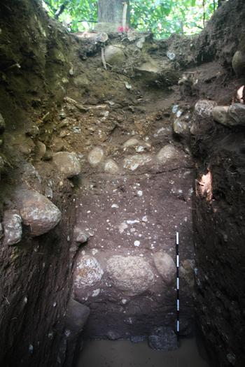
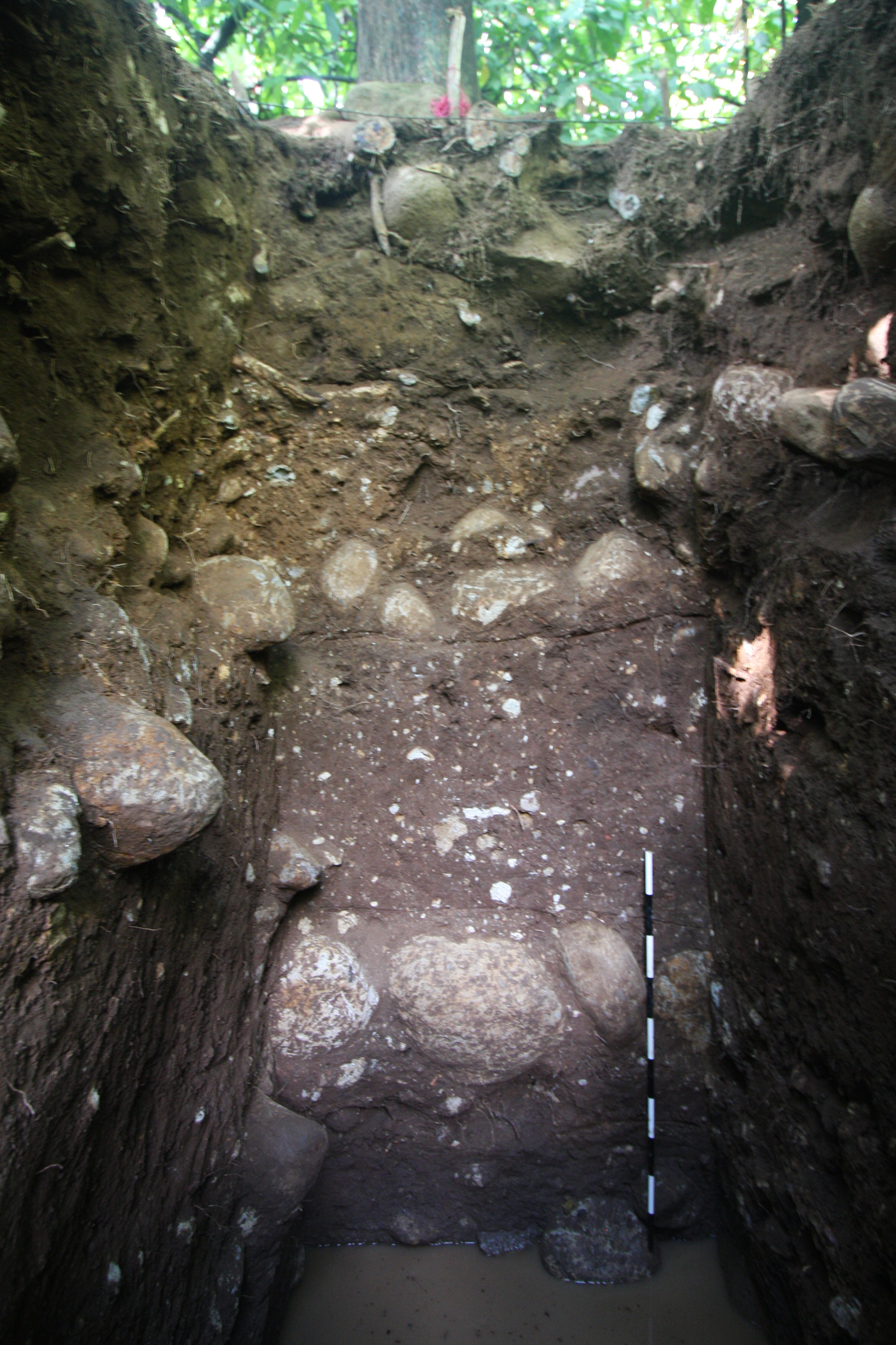
Photograph of south wall of Suboperation 4a, showing three Terminal Formative period construction episodes. Photograph by Rosenswig.
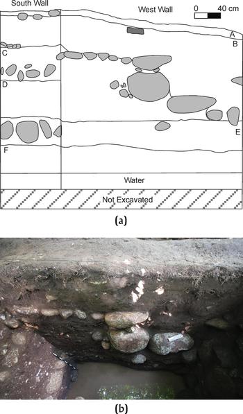
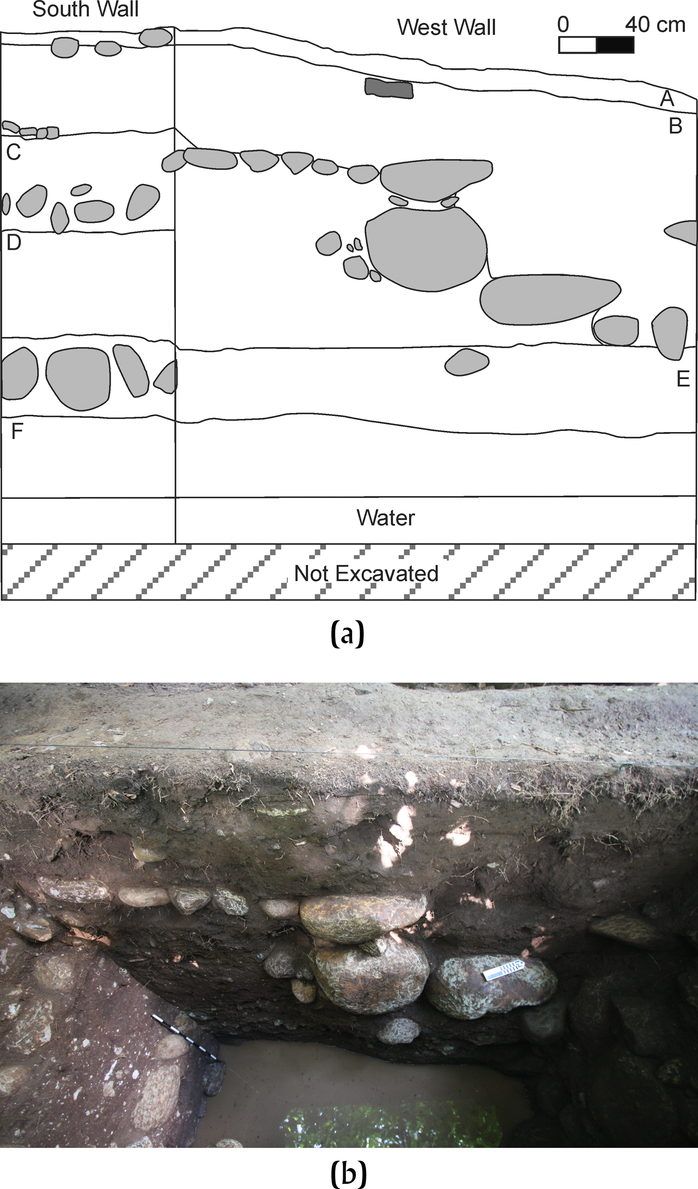
(a) Profile drawing and (b) photograph of west wall of Suboperation 4a, showing central staircase paved with stone dating to the Terminal Formative Itstapa phase. Drawing and photograph by Rosenswig.
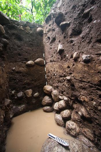
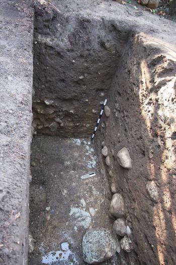
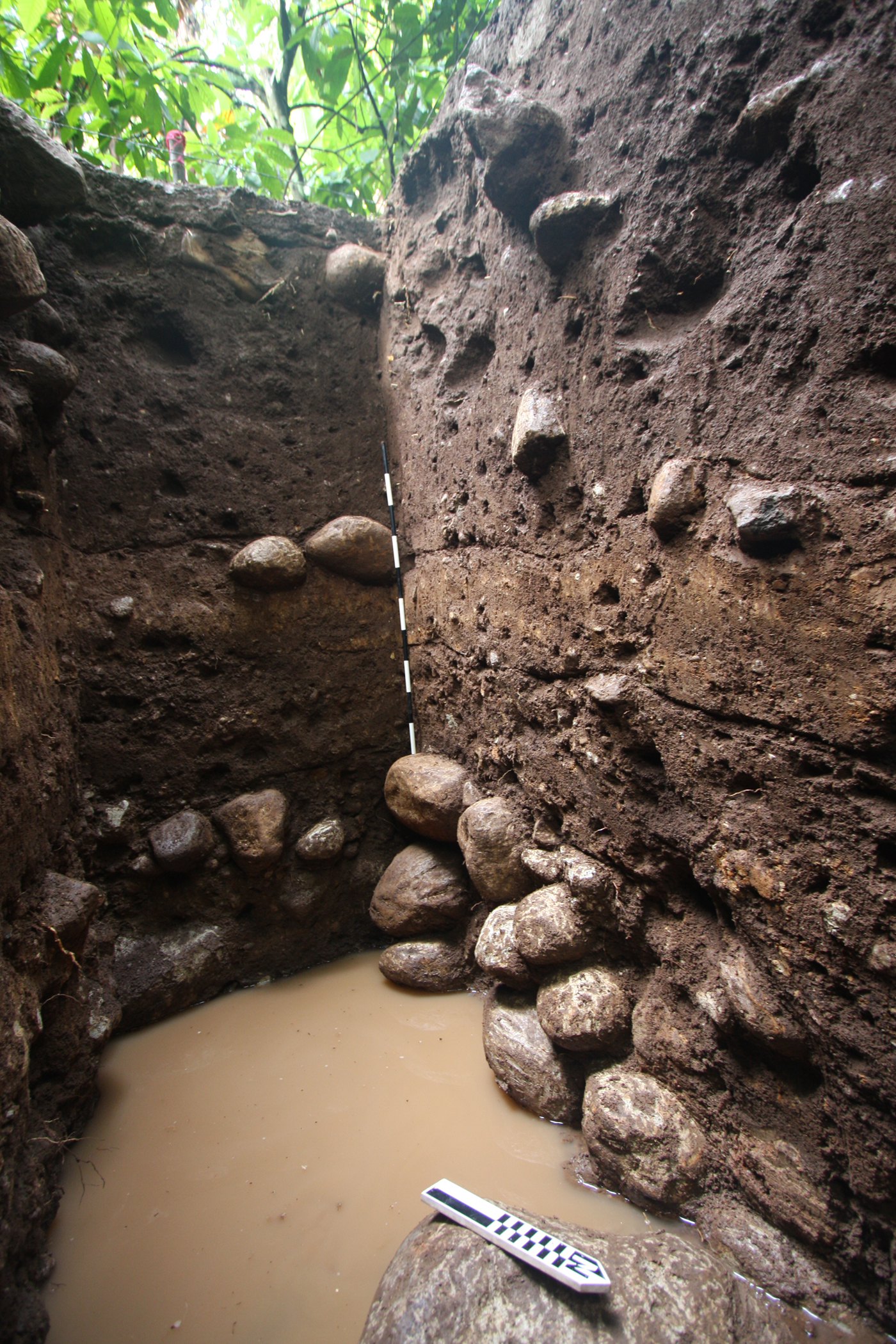
Photograph of the south and west walls of Suboperation 4b, showing buried Frontera-phase stone structure under Terminal Formative construction fill. Photograph by Rosenswig.
North Edge of the Mound 30 Platform
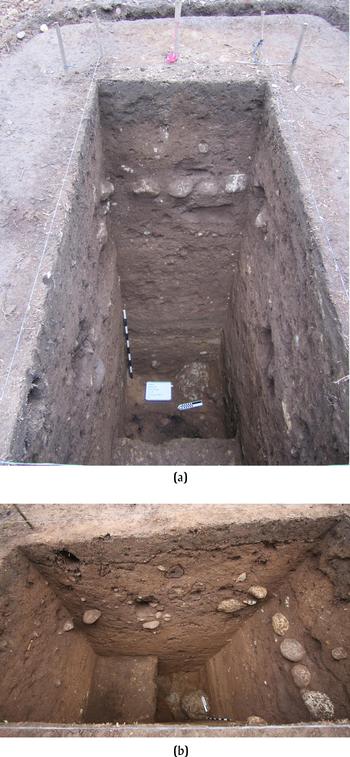
The northern half of the Mound 30 platform was built in three episodes during the Terminal Formative period. The construction episodes are clearly visible in the south wall of Suboperation 4a where two buried, stone-cobble surfaces are evident (Figure 3). Below the lower cobble surface, a dense, very dark-brown (7.5YR 2/2) midden was documented that contained Middle Formative ceramics (discussed later in this article). Between the two cobble surfaces is a dark-brown (10YR 3/3) matrix we interpret as construction fill that contains Terminal Formative Itstapa-phase (and earlier) ceramic sherds (Figure 3B). Above the top cobble surface is a light-brown (7.5YR 3/4) fill that also contains Terminal Formative sherds and extends up to the active root mat. Excavation results from Suboperations 3a and 4b, as well as 9a and 9b (see Figure 2), provide the same stratigraphic pattern of three distinct construction episodes but not all are so clearly defined by intact stone cobbles as those from Suboperation 4a (Rosenswig et al. Reference Rosenswig, Mendelsohn, Antonelli, Lieske and Córtes2014). Stela 40 and Altar 30 were found on the west edge of the platform (Mound 16; see Figure 2), between where Suboperations 9a and 9b were excavated (Clark and Lee Reference Clark and Lee2013:Figure 11), and so were likely placed there during the Itstapa phase (or later).
The Terminal Formative augmentation of the size of the Mound 30 platform was considerable. The platform's extents almost doubled and what was square during the Middle and Late Formative period expanded to its current rectangular shape and size. The area of expansion, beyond the square platform on which Mound 30a sits, measures 75 × 150 m and is 2 m high. This translates to approximately 22,500 m3 of fill. But why was so much effort expended here? The answer may lie in the shift of the monumental focus of the site center from lower Izapa to upper Izapa (i.e., Group F) that began during the Terminal Formative period (Lowe et al. Reference Lowe, Lee and Espinoza1982). Lidar data have recently allowed us to recognize a causeway that began at Group F and extended 270 m south towards lower Izapa (Rosenswig and Mendelsohn Reference Rosenswig and Mendelsohn2016). If religiously and/or politically motivated processions originated at Group F, and followed the causeway southward, then their point of entry (to what was by then Old Izapa) would have been Mounds 9 and 15 and the north edge of the Mound 30 platform (see Figure 1). Serving as an entry point to Old Izapa would explain why there was modification to what would have been the “back” of Mound 30a during the Middle and Late Formative period occupation of the site. A shift in Izapa's political center to Group F, and processions periodically proceeding to lower Izapa, would also explain why so many monuments were reset at Mound 9 after the older parts of Izapa (and Group B, in particular) were no longer the focus of construction efforts at the site.
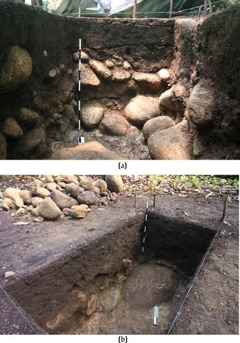
Suboperation 4a was excavated at the middle of the north edge of the Mound 30 platform and documents a central ramp and staircase in addition to three episodes of Terminal Formative construction. Figure 4 shows the south and west walls of Suboperation 4a where we encountered clear evidence of the stone cobble surfaces. Equivalent cobbles were not encountered in the east wall of Suboperation 4a. We did, however, remove a number of large, flat-topped cobbles during the course of excavating this unit and thought they were part of the construction fill. It was only once they were removed (and the unit's west wall became visible in profile), that we realized we must have removed the eastern-most edge of the ramp and staircase that terminated within the 1-m width of the excavation unit. It will be a relatively simple matter to determine the east-west extent of this ramp and staircase with future work.
The stratigraphy in each of the units excavated along the north edge of the Mound 30 platform (Suboperations 3a, 4a, and 4b) document the three construction episodes of the platform. Based on the presence of the pavement and boulder steps along the centerline of the platform's north edge (in Suboperation 4a), and its absence in two units other units excavated on either side (Suboperations 3a and 4b), we interpret this feature as a central staircase of an as-yet undetermined width. Figure 5 shows the south and west walls of Suboperation 4b where three episodes of construction are also evident (despite missing completely cobble-paved surfaces). At the bottom of Suboperation 4b, we documented a deeply buried stone structure measuring 65 cm in height. From the dark-brown (7.5YR 3/4) matrix north of this structure, we document unmixed Middle Formative midden remains, predominantly of Frontera age, and the ceramics are analyzed in the final section of this paper. This early structure was covered by a 40-cm-thick layer of reddish-brown (7.5YR 3/2) silty clay. Above this was another silty clay layer that was dark brown (7.5YR 4/4) in color, approximately the same thickness as the level below, and extends up to the two cobbles visible in the south wall that the top of the meter stick is resting against in Figure 5. The final construction layer was 90 cm thick and a lighter dark-brown (5YR 3/2) than those below. Above this was 30 cm of root mat. Each of these three fill layers contained a mixture of sherds, the most recent of which were Itstapa-phase types and, so, we interpret the timing of the extension of the platform to the end of the Terminal Formative period (cal a.d. 100–300).
Within the Mound 30 Platform
A single unit was excavated within the Mound 30 platform and further helps to date the platform's construction history. This excavation unit (Suboperation 11a) also provides stratigraphic association for Miscellaneous Monument 2 (aka El León), the oldest stone monument at the site inferred artistically in terms of the three-dimensional nature of its carving and contextually for its association with Mound 30a (Navarrete Reference Navarrete2013:19–21). Suboperation 11a was placed along the central axis of Mound 30a and 30 m north-northeast of this mound's north edge (Figure 2). This excavation unit was also 40 m west-northwest of El León. In Suboperation 11a, we documented a distinctive white clay layer, the top of which was 2 m below current ground surface (Figure 6). The height of the top of this clay layer is within 2 cm of that of the ground surface around the El León sculpture. The stratigraphy and associated radiocarbon assays documented in Suboperation 11a can thus be employed to date the depositional context of El León.
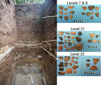
Photograph of the south wall of Suboperation 11a, showing a Middle Formative period plaster floor. Terminal Formative Itstapa-phase sherds from fill recovered above floor (Level 7 and 8) and Middle Formative Escalón-phase sherds recovered from within the floors (Level 21 and 22). Photographs by Rosenswig.

The white clay layer in Suboperation 11a was the result of multiple repavings of this ceremonial space during the Escalón phase. The south wall of Suboperation 11a shows three distinct episodes of white matrix deposition and a thin, dark level between each of them (Figure 6). This indicates an initial construction and at least two subsequent resurfacing or maintenance episodes. The white clay floors are actually grey (5Y 8/1) according to the Munsell standard. They were excavated as Levels 21 and 22 in Suboperation 11a. Within and below the clay surfaces, we recovered Escalón-phase ceramic types (along with a few dating to the Duende phase). Examples of some of these rim sherds are presented in Figure 6 from Levels 21 and 22. The first 30 cm below the floor in the south profile of Suboperation 11a (but as thick as 50 cm elsewhere in the unit) was a brown (2.5YR 3/3) matrix. This layer contained a noticeably dense concentration of obsidian, ground stone, and ceramics sherds during excavation. A 15-cm-thick level below contained the same matrix but also included a significant quantity of white clay. Below this, was a sandy orange-brown (2.5Y 6/8) matrix that also contained a high artifact density. The penultimate stratum was 15 cm thick and consisted of light-brown (5Y 5/3) clay with numerous small stone inclusions and very few artifacts. The final 40 cm excavated in Suboperation 11a was sterile rock and sandy clay bedrock that is known locally as “cascajo.”
Above the white clay floors documented in Suboperation 11a, we recovered significant quantities of Terminal Formative ceramics mixed with earlier period types. We interpret this matrix as construction fill that dates to the Itstapa phase and extends to the north edge of the platform. Unlike the stratigraphy documented in Suboperations 4a and 4b, distinct construction episodes were not evident.
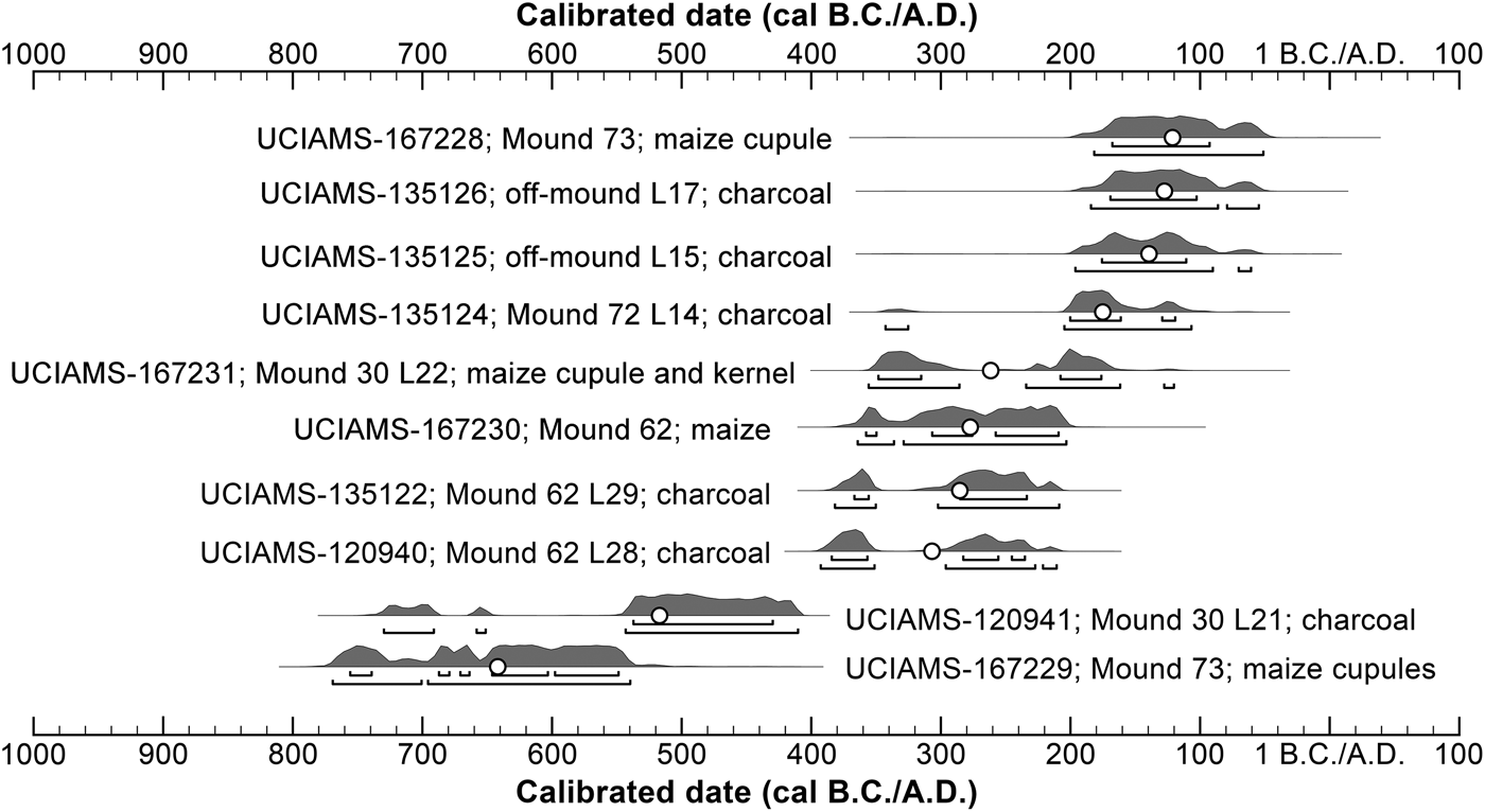
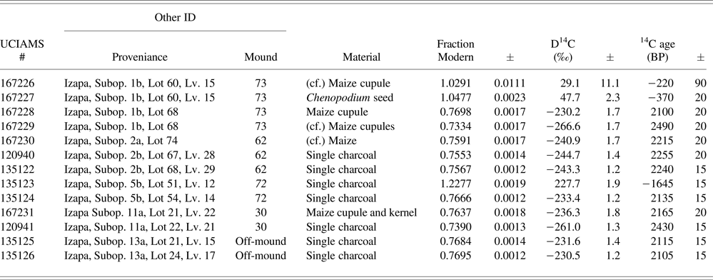
Ceramic analysis and radiocarbon assays along with stratigraphic evidence document a late Middle Formative platform covered with construction fill during the Itstapa phase and that the Mound 30 platform reached its current size. The ceramic sherds presented in Figure 6 exemplify those recovered from the Terminal Formative construction fill (documented in Levels 7 and 8) and those from below the floor are Middle Formative Escalón-phase types (Levels 21 and 22). Two radiocarbon assays were recovered from these clay surfaces. One was run from a maize cupule and kernel that produced a 2-sigma result of 355–120 cal b.c. and the second was from a piece of charcoal embedded within the floor that dates to 729–410 cal b.c. (Figure 7; Table 2). We interpret the charcoal as dating the time the floor was first built (i.e., the Escalón phase) and the maize being from sometime during its later use (during the Frontera or possibly Guillén phase). The downward percolation of small macrobotanical remains is a common occurrence in the formation of long-occupied settlements, and something we have also documented in the earlier village of Cuauhtémoc on the Soconusco coastal plain (see Rosenswig et al. Reference Rosenswig, VanDerwarker, Culleton and Kennett2015a). Suboperation 11a provides hints of how the area north of Mound 30a was used by the residents of Izapa from Middle through Terminal Formative times. First as non-architectural occupation area north of Mound 30a during the Escalón and Duende phases, then as a paved surface through to the Guillén phase, and finally as an expanded platform during the Itstapa phase. The Escalón- (and possibly Duende-) phase deposits below the clay floors provide a sealed context from the early establishment of the site as a monumental center—and will be the focus of future research.
Error ranges of radiocarbon accelerator mass spectrometry (AMS) dates from Izapa. Image by Rosenswig.

New radiocarbon AMS dates from Izapa. Subop., Suboperation; Lv. Level.

North of the Mound 30 Platform
Four units excavated north of the Mound 30 platform (Suboperations 7a, 8a, 8b, 8c; see Figure 2) demonstrate that this area of Izapa had significant earth moving resulting in it being relatively clean of debris. Figure 8 shows what Suboperations 8a and 8c looked like after excavations were complete. Each of these units reached a depth of approximately 1 meter, and excavations were terminated when the bottom of each consisted of large, jumbled river cobbles. The cobbles must have been washed down the small stream that runs directly north of Suboperations 8c, 8a, and 7a (see Figure 2) before the establishment of Izapa. Very low artifact densities are documented in each of these four units (Table 3) and the sherds were small and quite worn. Low artifact density in the area around monumental architecture at Izapa is consistent with collecting surrounding soils to build mounds, as has been documented within the site core (Lowe et al. Reference Lowe, Lee and Espinoza1982). Intact late Middle Formative deposits are documented in Suboperations 4a and 4b below the platform but completely absent at all of these units only 30 m away. The comparison of Suboperations 8a and 8b to Suboperations 4a, 4b, and 11a confirm that we must target deposits preserved below existing architecture to recover intact early features or refuse at Izapa. Surrounding earth being collected and used to build mounds is precisely what the NWAF reported, but we had to learn the lesson for ourselves. By comparing ceramic sherd densities from these four test pits (i.e., Suboperations 7a, 8a, 8,b and 8c) north of the Mound 30 platform to the densities in mound fill and underlying middens, evidence of site-wide depositional processes that can be quantitatively identified.
Photographs of the (a) south wall of Suboperation 8a and (b) the west and north wall of Suboperation 8c; areas mined for construction fill north of the Mound 30 platform at Izapa. Photographs by Rosenswig.

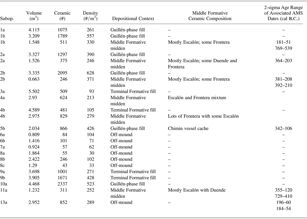
Density of ceramics excavated at Izapa by suboperation (Subop.). Volume and ceramic counts are only for contexts with clear depositional interpretations, and are thus a subset of the totals reported in Table 1.

Site-Wide Ceramic Density Patterns
Ceramic-sherd densities provide insight into formation processes when temporal and function designations of the deposits can be ascertained (Table 3). The numbers in Table 3 are different from those presented in Table 1, as the latter included ceramic sums from all excavated contexts. Table 3 reports results only from contexts where the function of the matrix can be reliably ascertained. In the case of Suboperations 7a, 8a, 8b and 8c, the top 20 cm of active root mat was excluded from consideration, as was the culturally sterile matrix recovered from the lowest levels. Therefore, reported densities are from pre-Hispanic times and represent evidence of site use.
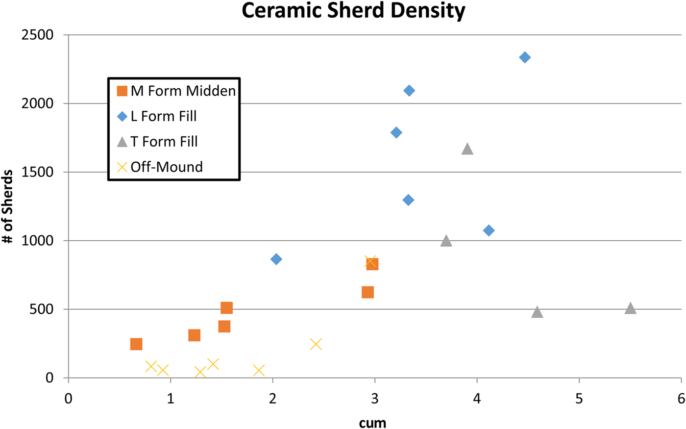
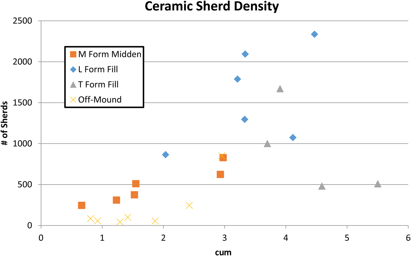
A clear pattern that emerges when comparing ceramic densities is that off-mound contexts around the monumental architecture at Izapa contain consistently lower sherd densities (between 30 and 102 sherds/m3) than Middle Formative middens in Suboperations 4a, 4b, and 11a that have 213, 279, and 252 sherds/m3, respectively (Table 3). Figure 9 illustrates this graphically with low-density, off-mound contexts represented by “Xs” that fall below the squares that correspond to Middle Formative midden contexts. The Terminal Formative construction fill documented at the north edge of the Mound 30 platform contains ceramic densities of 93 and 105 sherds/m3 (triangles in bottom right of Figure 9), which are consistent with off-mound densities. In contrast, ceramic densities documented at Suboperations 9a and 9b (271 and 428 sherds/m3) are consistent with Middle Formative midden deposits as well as Late Formative construction fill documented across the site (see Table 3 and triangles mixed in with other shapes in Figure 9). This indicates that the section of the Mound 30 platform documented by Suboperations 9a and 9b was built using soils that contained much denser cultural material and may have been acquired before the more eastern parts of the platform (documented by Suboperations 3a and 4b). As Rosenswig (Reference Rosenswig2009) has described elsewhere (following Schiffer Reference Schiffer1987), documenting site formation processes is an essential first step in reconstructing the behavior of past peoples. In this case, stratigraphy and temporal designations of ceramic assemblages, combined with sherd densities, reveal the function as well as the sequence of monumental construction episodes at Izapa.
Chart of excavated volumes and ceramic sherd counts representing different densities by depositional context. Chart by Rosenswig.
Excavations South of Group B
Izapa's E-Group
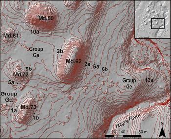
An E-Group was recently recognized at Izapa based on the newly acquired IRSP lidar data (Rosenswig et al. Reference Rosenswig, López-Torrijos, Antonelli and Mendelsohn2013). In contrast to the way Mounds 71 and 73 were originally depicted, as two ovals (Lowe et al. Reference Lowe, Lee and Espinoza1982:Inset), the lidar data document them in the shape and orientation expected for an E-Group (see Figure 1). Mounds 71 and 73 are located along the site's original Middle Formative central axis, directly south of Mound 30a. This is precisely where an E-Group would be expected. First defined at Uaxactun (Blom Reference Blom1924), E-Groups are identified as a pair of mounds, a conical one to the west and a long, linear one to the east, that together are located south of the earliest principal mound of a site. E-Groups have long been interpreted as serving astronomical functions (Aimers and Rice Reference Aimers and Rice2006; Clark and Hansen Reference Clark, Hansen, Inomata and Houston2001) and the astrological alignments of Izapa's site layout is explored further elsewhere (Blake et al. Reference Blake, Rosenswig and Waber2015).
We wanted to investigate the newly recognized E-Group during the 2012 season. Unfortunately, we were not granted permission to excavate at Mound 71. Permission was granted to work at Mounds 72 and 73, however, and we documented the late Middle Formative establishment of the E-Group and significant expansion during the Guillén phase. Two units excavated on the centerline axis east and west of Mound 73 (Figure 10). Suboperation 1a was excavated on the west side of Mound 73 and in it we documented the remains of a single episode of construction and ceramic sherds dating to the Late Formative Guillén phase and earlier. The matrix consisted of dark-brown (10YR 3/2) loamy clay in the upper meter of the unit, transitioning to a strong-brown (10YR 4/6) silty clay with fine sand in the lower meter. The entire unit was riddled with rodent burrows and this Late Formative construction fill was quite distinctive.
Location of Izapa Regional Settlement Project (IRSP) excavation units south of Group B. Inset map indicates location of map in lower Izapa. Map by Rosenswig.
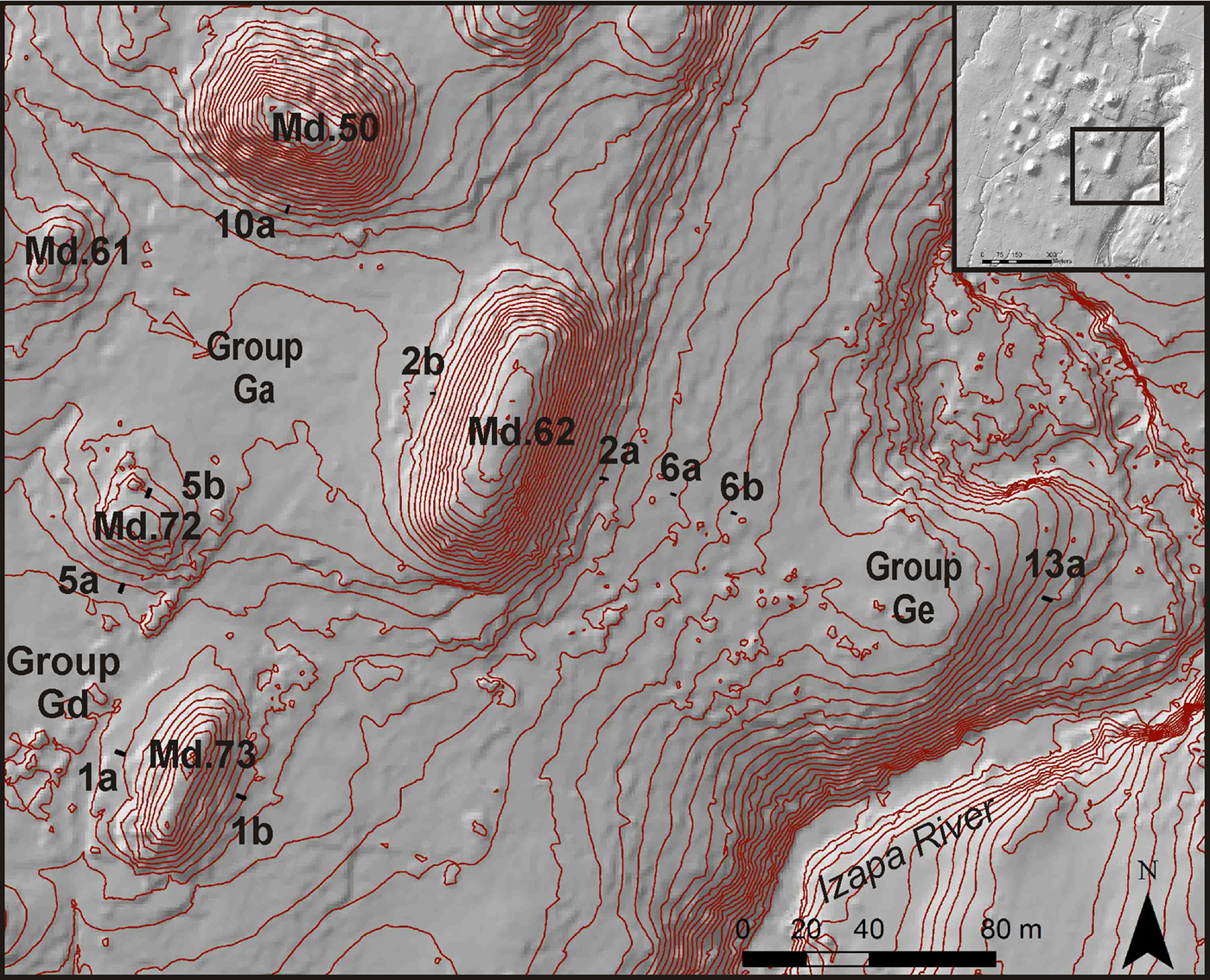
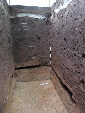
Suboperation 1b was excavated on the east side of Mound 73 and also documented a single episode of construction during the Late Formative period (Figure 11). The top 20 cm of this unit were active root mat and below this a 10-cm layer of ash laid down by the 1902 eruption of Santa Marta in Guatemala is clearly visible at the top of the unit shown in Figure 11. Next, we documented matrix that contained Guillén-phase (and earlier) ceramics that we interpret as Late Formative period construction fill. This layer was 1–1.4 m thick and consisted of dark-brown (7.5YR 3/2) clayey loam of the same type documented in Suboperation 1a. Ceramic density from Suboperation 1b is more than twice as high as the construction fill documented in Suboperation 1a (Table 3) and, so, indicates that more cultural materials were mined to build the east side of Mound 73 than the west side that faced into Group Gd. This is what we would expect if the plaza was kept relatively clean of debris and trash accumulated more on the west side of the mound and away from a formal plaza.
Photograph of the south and east walls of Suboperation 1b with Middle Formative period midden removed, below Guillén-phase construction fill. Note volcanic ash layer from 1902 eruption at the top of the profile. Photograph by Rosenswig.

Below the Late Formative construction fill in Suboperation 1b, we documented an intact, Middle Formative midden. The midden was 20–40 cm thick and contained exclusively Escalón and Frontera-phase ceramics (analyzed below), indicating that this locale was occupied for at least three centuries prior to the site's Guillén-phase apogee. The Middle Formative midden layer was preserved by the overlying mound just above bedrock, as is shown in Figure 11, after we had removed it from the south and east walls of Suboperation 1b. The density of ceramics in this midden is relatively high but lower than the overlying Late Formative construction fill documented in Suboperation 1b (see Table 3). Two maize cupules recovered from this Middle Formative midden produced different dates (Figure 7; Table 3). One is consistent with the established chronology of the Escalón phase with a 2-sigma result of 769–539 cal b.c. The other produced a 2–sigma result of 181–51 cal b.c. and therefore may be intrusive from the overlying Guillén-phase fill.
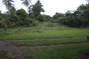
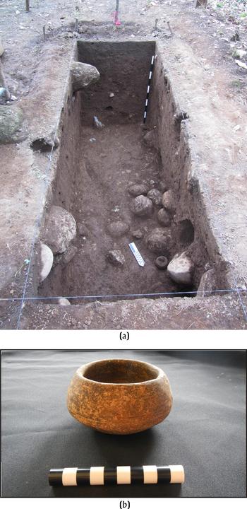
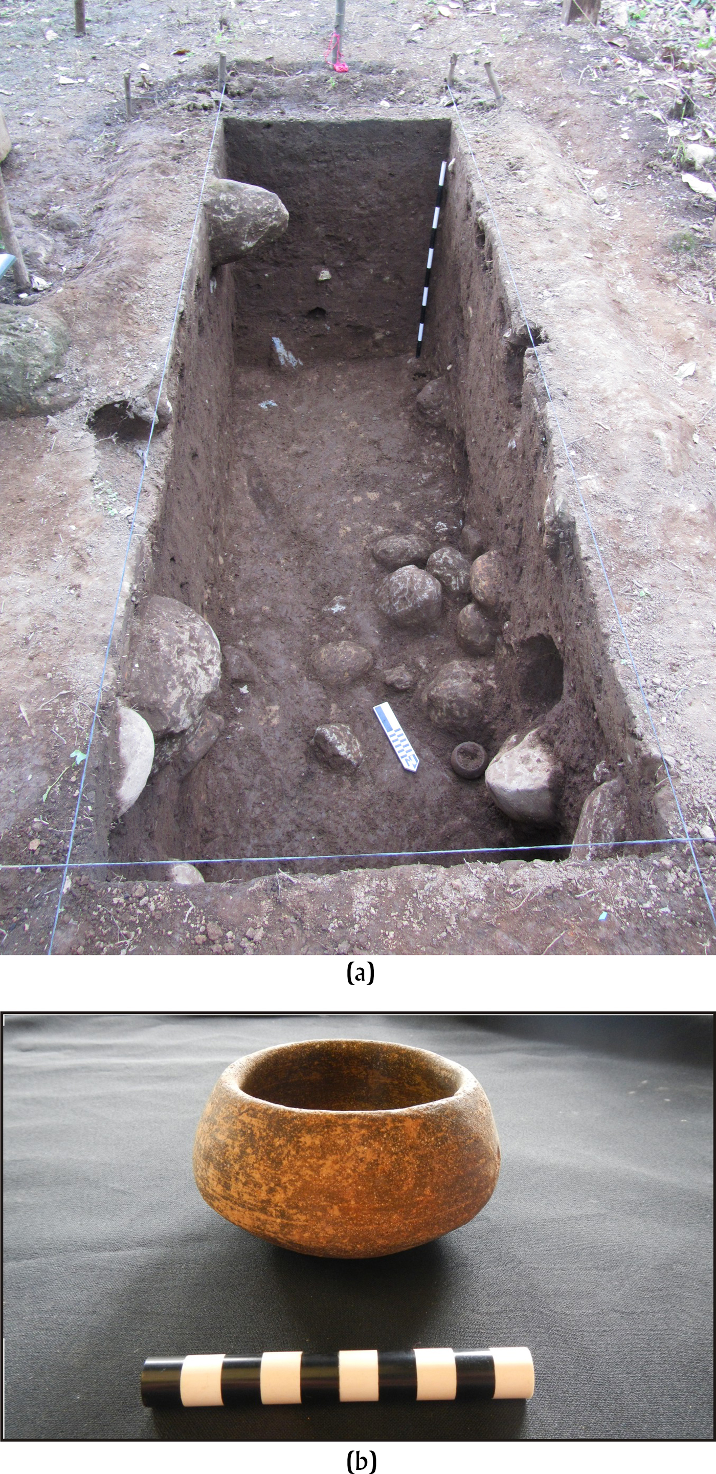
Excavations were also undertaken on the north and south sides of Mound 72 (Figure 12), which closes off the north side of Group Gd formed with Mounds 71 and 73. Excavations at this mound documented that it was first built during the Middle Formative period, and that later the south side was augmented during the Guillén phase. There is additional Itstapa phase debris in the uppermost levels in Suboperation 5a, on the south side of Mound 72. A meter below current ground surface on the north side of Mound 72, a complete vessel cache was documented in Suboperation 5b within the stone covering the initial construction episode of the mound (Figure 13A). The vessel is a small bowl (Figure 13B) from the Escalón–Frontera-phase Chinín Sandy Black Group (Lowe et al. Reference Lowe, Ekholm and Clark2013:36–39). A carbon sample collected 1 m south (i.e., towards the center) and 30 cm lower than where the vessel was encountered, produced a 2-sigma result of 342–106 cal b.c. Lot 51 was an area of dark soil beneath some of the stones pictured in Figure 13A but, given that the radiocarbon result (Table 2) was modern, this must have been intrusive and brought down into the mound by rodent burrowing. We then were able to establish that Mound 72, which lies just over 300 meters directly south (along the site's primary alignment) of Mound 30a, was built during the Escalón and Frontera phase and augmented in Guillén-phase times.
Photograph of Mound 72 with Suboperation 5a. Image faces west. Photograph by Rosenswig.

(a) Photograph of Suboperation 5b with Middle Formative Chinín Sandy Black Group vessel in situ next to north arrow and (b) the vessel once cleaned. Photographs by Rosenswig.
Two of the mounds that form a plaza for Izapa's E-Group were built during the late Middle Formative and significantly augmented during the Guillén-phase apogee of the site. Duende-phase remains may be contained within the mounds’ cores, but we have not yet penetrated them deeply enough to find out. In contrast, no evidence of Hato-phase construction was present at either mound, indicating a cessation of construction at Izapa's E-Group by 100 cal b.c., which is consistent with IRSP survey results (Rosenswig and Mendelsohn Reference Rosenswig and Mendelsohn2016; Rosenswig et al. Reference Rosenswig, López-Torrijos, Antonelli and Mendelsohn2013).
Mound 62
Mound 62 is 100 m long, 15 m high, and defines the east edge of Group Ga (Figure 10). This mound defines the eastern extent of all monumental construction at Izapa and, along with Mound 60, could be interpreted as a second E-Group (see Figure 1). Mound 62 had never been previously tested and we placed excavation units on its west and east edges. Our excavations document two episodes of Late Formative mound construction with Middle Formative occupation buried below in both excavated units. In Suboperation 2b, on the west side of Mound 62, we documented two episodes of construction fill topped by a cobble surface (Figure 14). The soil above the cobbles we interpret as the result of erosion down the steep western face of this mound. The soil within which the row of cobbles was documented was a very dark-brown (10YR 2/2) clayey loam with silty, white inclusions and was 70 cm thick. This was the more recent construction episode we documented at Mound 62. Below was a 10-cm-thick layer of mixed brown (10YR 3/3) and light-brown (10YR 5/6) clay that we interpret as the surface of an earlier construction level. The earlier construction layer itself was 60 cm thick in the unit and consisted of brown (10YR 3/3) loamy clay. Both of these strata contained ceramics from many Formative period phases but the majority were Escalón, Frontera, and Guillén, so we interpret them as the edge of the final two construction episodes of Mound 62 during the Guillén phase while there was still late Middle Formative occupation debris in the vicinity to be incorporated into the mound as fill. In fact, these Late Formative period fill deposits contained the highest density of sherds (628/m3) documented in any of the 2012 excavations (Figure 9; Table 3). There are almost certainly earlier episodes of construction waiting to be documented within this massive mound.
Photographs of (a) the east wall of Suboperation 2b with Middle Formative period hearth feature visible below Guillén-phase construction fill as well as (b) the north wall of the unit once excavations completed. Photographs by Rosenswig.

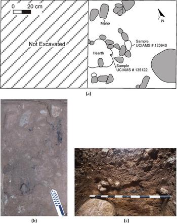
Intact Middle Formative period deposits were also documented at the bottom of Suboperation 2b, on the west edge of Mound 62. Beginning at the top of the meter stick (in the northeast corner of the unit, visible in Figure 14) was a 10-cm-thick layer of yellowish-brown (10YR 5/6) clay mixed with silty white inclusions and reddish-orange clay. Below this was 10 cm of brown (10YR 3/3) sandy clay and another 10 cm of similar brown clay with black sand, red clay, and small pebble inclusions. At this depth, we reduced the size of Suboperation 2b and excavated only the eastern 1 × 1 m (i.e., towards the center of the mound), as we were 3 m below ground surface and having problems entering and exiting the unit. In the 1 × 1-m extension, another 50 cm of cultural deposits were documented that contained only late Middle Formative ceramics. From these deeply buried deposits, we also documented a hearth feature from which two carbon samples were recovered. The hearth was encountered just above bedrock, the final 30 cm we excavated contained virtually no artifacts, and we stopped excavating when large rocks within the cascajo were encountered that could not be removed.
At the very bottom of Suboperation 2b, we documented a Middle Formative, stone-lined hearth feature from which carbon samples were recovered. Figure 15a is a plan map of the feature that extends into the unexcavated western half of the unit. Rocks measuring from 10–20 cm long defined the edges of the hearth, and the location of a complete mano and two dated carbon samples are indicated in Figure 15a. All rocks were burnt and covered in a layer of carbon. Figure 15b is a photograph of the carbon (dated as UCIAMS #120940) after the rock depicted as unfilled in Figure 15a had been removed. The cramped, wet, muddy excavation conditions made representative photographs impossible for us to take as we were exposing it from above. Figure 15c shows what was left of the hearth feature in the east wall of the 1 × 1-m unit excavated to cascajo. Five small rocks (5–7 cm in diameter) are still in the profile; another three had fallen out and only their impressions remain. The approximately 40 centimeters of soil above and around the rocks of the hearth consisted of clay that changed from brown (10YR 4/4) at the top to light brown (10YR) at the bottom. It is from this matrix that Escalón and Frontera ceramic sherds were recovered (and are discussed further at the end of the paper). If there were any pre-Escalón materials at this location, they had been scrapped away to build whatever architecture is buried within Mound 62. Five Duende-phase rim sherds were recovered from the Escalón- and Frontera-phase contexts but nothing from the Conchas phase or from any Early Formative period. The hearth is associated with a lot of carbon and a dated sample from within the feature produced a 2-sigma result of 381–208 cal b.c. and the remains of a burnt piece of wood produced a date of 392–210 cal b.c. (Table 2). These two dates are so closely clustered that they could be from the same year and each calibrates to the end of the Frontera phase. The late Middle Formative occupation at this area of the site was sealed when Mound 62 was dramatically augmented during the Guillén phase.
(a) Plan drawing of Middle Formative period hearth feature in Suboperation 2b. Photographs of (b) carbon and rocks before removal, and (c) remains of the feature in the west wall after excavation. Drawing and photographs by Rosenswig.

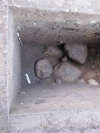
Excavations were also undertaken on the east side of Mound 62 as Suboperation 2a. The stratigraphy on the east side of the mound was very similar to that documented in Suboperation 2b, on the west side. Both units were excavated at the same time and document two episodes of Late Formative construction with intact Middle Formative occupation below. The 40 cm of matrix above cascajo in Suboperation 2a contained dense concentrations of late Middle Formative sherds (246 sherds/m3; see Table 3) and is interpreted as a midden predating the construction of Mound 62. As with Suboperation 2b, if there are remains predating the late Middle Formative period they were removed from this location long ago. Flotation of soil from the midden recovered a maize remain that produced a 2-sigma, corrected result of 364–203 cal b.c. (Table 2). This date is consistent with the established chronology for the Frontera (or early Guillén) phase. The identified sherds from the matrix are Escalón-phase types so this radiocarbon date is more recent than expected. At the east end of the south wall of Suboperation 2a, a 130-cm long cobble surface or rock alignment was documented just above bedrock (Figure 16). This feature is 1.5 m below ground surface and would be a promising location for future excavations. Intact features dating to Frontera phase on both sides of Mound 62 (with Guillén phase fill over this) confirms our assumption that the only place to document in situ Middle Formative occupation is under later architecture.
Middle Formative period cobble construction surface above bedrock in Suboperation 2a, 1.5 m below current ground surface. Photograph by Rosenswig.

Down by the River
Three test pits were excavated east of Mound 62 towards the Izapa River. Suboperation 6a was placed 20 m east of Suboperation 2a (i.e., the east edge of Mound 62) and Suboperation 6b was excavated another 40 m to the east (see Figure 10). Both units measured 1 × 2 m and had ash from the 1902 eruption of Santa Marta documented within 20 cm at the top, and both reached cascajo 1 m from the current ground surface. The density of ceramic sherds documented in Suboperations 6a and 6b falls within the same range as the four off-mound units excavated north of Mound 30 (see Table 3 and Figure 9) and discussed previously (i.e., Suboperations 7a, 8a, 8b, and 8c). This consistency of low ceramic sherd densities from separate areas of the site, that were all presumably being mined for construction fill, provides a quantitative baseline for interpreting formation processes at Izapa.
We had originally planned to excavate a test unit every 20 m between Mound 62 and the Izapa River. Due to lack of cultural materials (as well as limited time and research funds), however, only one more unit (Suboperation 13a) was excavated along the same axis but much closer to the river (see Figure 10). The placement of Suboperation 13a was on the steep slope below Group Ge where a row of seven uncarved stelae (Stelae 73–79) and paired altars (Altars 63–68 and 75) were documented by the NWAF (see Lowe et al. Reference Lowe, Lee and Espinoza1982:Inset). Below topsoil and ash from the 1902 eruption of Santa Marta, all soil in Suboperation 13a was very dark-brown (10YR 2/2) slightly clayey loam. Soil terminated at large boulders (presumably from floods of the Izapa River) located between 150–190 cm below current ground surface. Two large pieces of carbon were recovered from just above the boulders (Figure 17) and produced corrected, 2-sigma date ranges of 196–60 cal b.c. and 184–54 cal b.c. (Table 2; Figure 7). Interpretation of carbon found floating in soil matrix must be made with caution but some activity resulted in burning occurred at this location during Guillén times (or at the very beginning of the Hato phase). Ceramic density from the Suboperation 13a matrix is informative as 289 sherds/m3 is well within the range of midden deposits elsewhere (Table 3). This ceramic sherd density stands out in Figure 9 as it is the only sampled off-mound context that falls within the density of middens. The location of this unit (between the row of stelae and the Izapa River) and its distance from large mounds make it an unlikely place to mine soils to serve as construction fill. Results from a single 1 × 2-m sample are necessarily preliminary but this off-mound location contrasts with the significantly lower ceramic densities at other off-mound locations located closer to monumental constructions (Figure 9). There thus seems to have been a limit to how far the builders of Izapa were willing to transport soils for mound construction.
Photograph of Suboperation 13a with carbon sample visible between the large stone and north wall of unit, 10 cm north of north arrow. Photograph by Rosenswig.

CERAMIC ANALYSIS
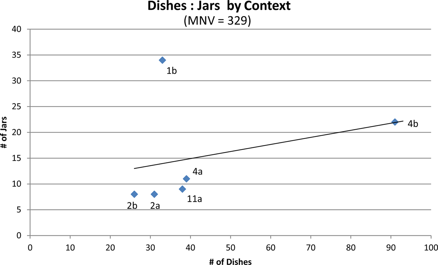
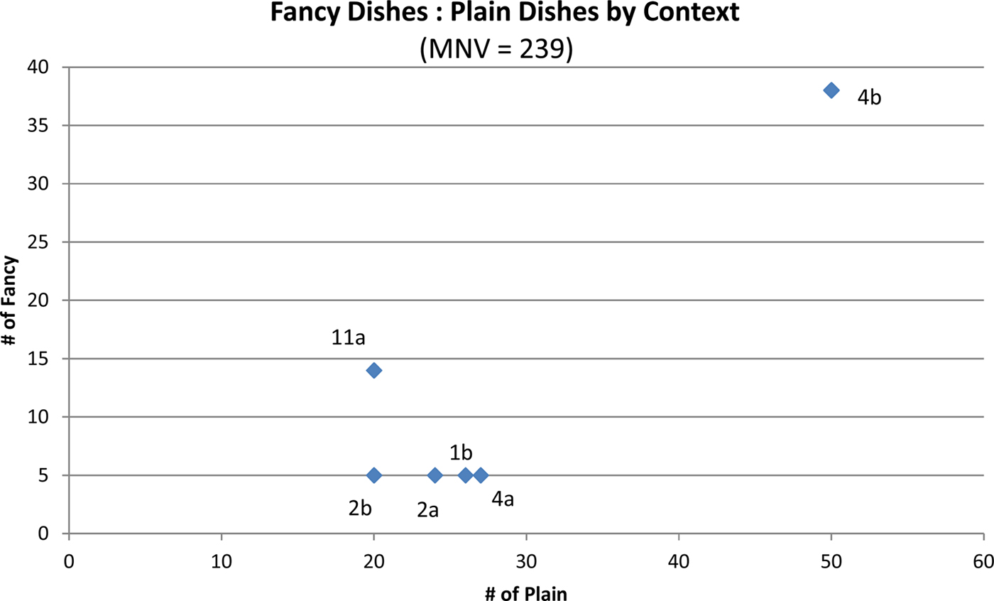
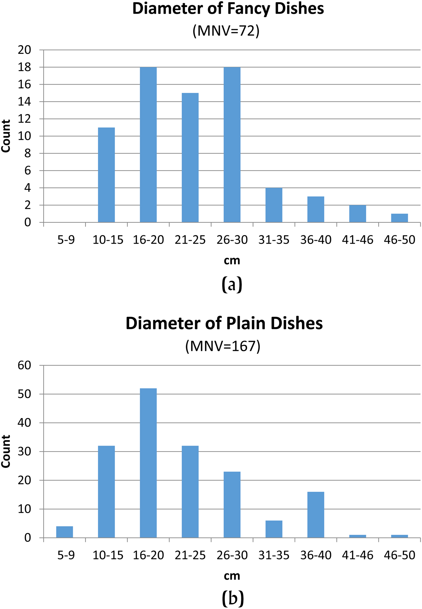
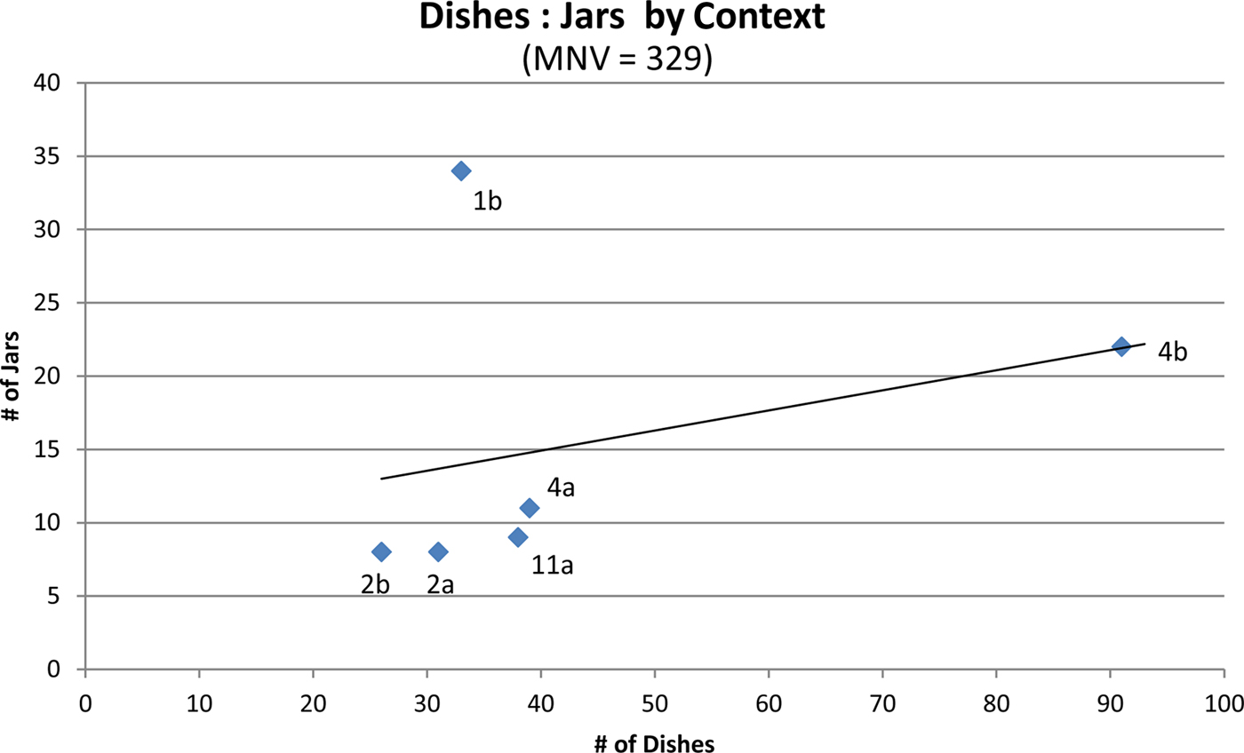
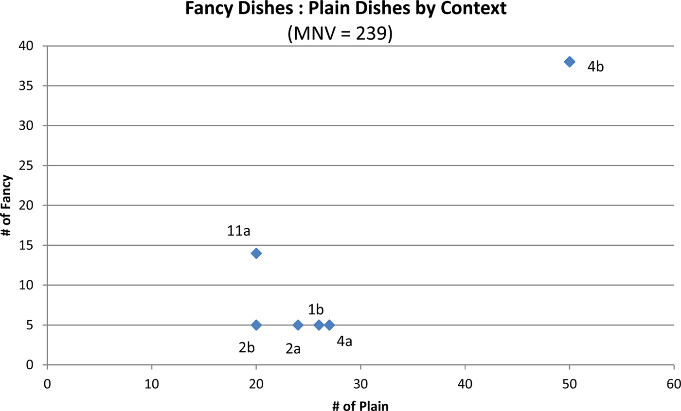
In this section we describe some formal and metric patterns from analysis of ceramics recovered from six locations where late Middle Formative middens were encountered. These midden deposits have been described in the course of this paper, as have associated AMS dates and overall sherd densities compared with other depositional contexts (Table 3). For the analysis that follows, we do not differentiate between the Escalón and Frontera phases due to recovery of types from both phases in many of the excavation contexts. Equally important in our decision to combine these two phases is that the ceramic assemblages share more types than are unique to each phase (Lowe et al. Reference Lowe, Ekholm and Clark2013:33–43). Two separate phases were defined for the late Middle Formative period where other investigators might have defined them as two facets of the same phase. The Escalón phase is identified primarily by waxy types, clearly related to the Mamom tradition, and these types are missing from the Frontera phase. The Frontera phase is defined by the novel Mundet Red serving vessels with wide, everted rims (Lowe et al. Reference Lowe, Ekholm and Clark2013:45–46). Mundet Red is missing from the Escalón phase and flat-bottom serving dishes with wide everted rims are a clear precursor to this form made during the following Guillén phase from the Tuzantan type (Lowe et al. Reference Lowe, Ekholm and Clark2013:53–57). The comparisons presented below are intended as a preliminary functional characterization of late Middle Formative (750–300 b.c.) behavior reflected in ceramic containers. Izapa was the center of a regional kingdom at this time (Rosenswig Reference Rosenswig2016; Rosenswig and López-Torrijos Reference Rosenswig and López-Torrijos2018; Rosenswig et al. Reference Rosenswig, López-Torrijos and Antonelli2015b) but the extent of monumental architecture was smaller than during the following Guillén phase (see Figure 1) and stelae had not yet been erected. The ceramic patterns discussed here therefore inform the first three or four centuries of the capital's occupation prior to the kingdom's apogee. We begin by comparing overall proportions of dishes to jars for each of the six contexts (Figure 18). Next, we compare the proportion of fancy to plain dishes from each of these contexts (Figure 19). Then, we examine dish rim diameter overall and compare the range of rim diameters between fancy dishes and plain, more crudely constructed, vessels (Figure 20).
Dish to jar ratio from late Middle Formative period midden contexts at Izapa. Labels correspond to Suboperations. Image by Rosenswig.
Ratio of fancy to plain dishes from late Middle Formative period midden contexts at Izapa. Labels correspond to Suboperations. Image by Rosenswig.
Rim diameters of (a) fancy and (b) plain dishes from assemblage-wide late Middle Formative period midden deposits at Izapa. Graphs by Rosenswig.
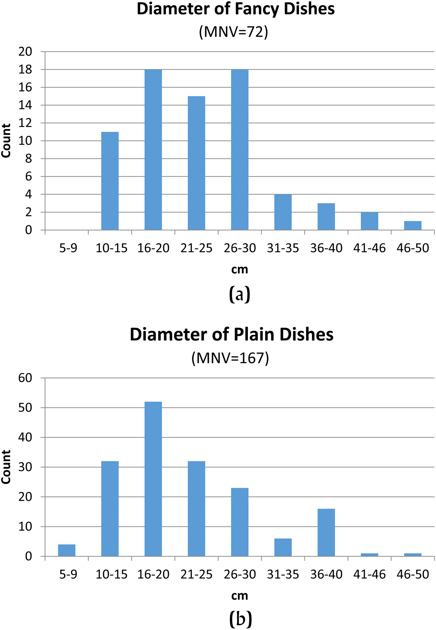
The ceramic sample examined for the following analysis is based on a minimum number of vessels (MNV) of 358 from late Middle Formative midden contexts. In the sample, refits of the same type, size, and thickness were only counted once to establish a MNV. Use of MNV mitigates against vessels with large orifice diameters being over-represented as occurs when simple rim-sherd counts are used (Rosenswig Reference Rosenswig2010:151). Of the total MNV sample, 25 were excluded from the analysis due to not being Escalón or Frontera types: three Early Formative types, two from the Guillén phase, and 20 Duende-phase types. Four more rim sherds were identified to type but form could not be determined so the sherds were also excluded from the following analysis. The total interpreted universe of late Middle Formative ceramic MNV was therefore 329 vessels.
We infer vessel function based on shape and whether it was elaborately decorated or not (see Lesure Reference Lesure1998). Our category “dishes” includes a range of wall and lip shapes (such as outflaring, outleaning, direct, everted, and composite silhouette) but all have equivalent or smaller internal diameters than the orifice openings. Orifice diameter is therefore a proxy measure for relative dish size. Fancy dishes are interpreted as holding food for eating, serving, displaying, and so on. Plain dishes could also be used to cook and serve food. In contrast, jars all have significantly restricted necks so that their orifice diameter is a poor indicator of vessel size. For the following analyses, a relatively small number of tecomates (neckless jars) are included in the jar category, as they would have served a similar range of functions. Small jars, especially those that are highly decorated, could be used to serve liquids. Large jars, especially plain ones, were used to store both food and liquids. Jars of all sizes can also be used to cook foods, especially stews and soups, and liquid evaporation is more limited than in open-orifice vessels.
Figure 18 plots the proportion of dishes to jars from the six Middle Formative midden assemblages. The midden from the east of Mound 73 (Suboperation 1b) contains similar proportion of these two vessel forms, which contrasts with the other five contexts that have ceramic vessel assemblages that are each dominated by dishes. A dish-dominated assemblage reflects the serving and consumption of food occurred more than their preparation and storage. The ceramic assemblage from Suboperation 1b may therefore reflect a more complete range of domestic activities that resulted in the formation of this midden compared to other documented contexts. Dish-dominated assemblages characterize the other five midden samples and suggest that activities carried out at those locations consisted of serving and consuming, rather than preparation and storage of, food. Suboperations 4a, 4b, and 11a were all immediately north of Mound 30a (see Figure 2) and Suboperations 2a and 2b, on either side of Mound 62 (see Figure 10), were very centrally located within Izapa's monumental center. The east side of Mound 73 was less centrally located relative to the Middle Formative site center (Figure 1) and, so, we infer that this area of the site served a more residential function than documented by the other late Middle Formative midden samples.
The proportion of fancy to plain dishes provides further hints as to the type of activities that occurred in the areas of Izapa we documented north of Mound 30a, around Mound 62, and east of Mound 73. Four of the sampled midden contexts contained relatively more plain dishes (Figure 19). In contrast, both middens documented by Suboperations 11a and 4b contained relatively more fancy dishes (i.e., they were found in more equal numbers compared to plain dishes). Both units were in ritually and politically important areas of Izapa during the site's late Middle Formative occupation. Suboperation 11a was located quite literally in the shadow of Mound 30a, as well as being near El León, the only Middle Formative sculpture at Izapa (see Figure 2). The midden documented in Suboperation 4b came from a stone building (Figure 5) to the north of Suboperation 11a. Food was consumed from fancier vessels here than elsewhere at the site. The midden deposits sampled in Suboperations 11 and 4b are the debris resulting from ritually important activities and are to be expected near important temples and sculptures.
The final quantitative pattern documented from ceramic vessel debris is a comparison of rim diameters for fancy and plain dishes from the six midden contexts (Figure 20). The rim diameter of an open dish provides a good approximation of its size, and so, the assemblage-wide comparisons of this metric allow us to infer general functions of decorated dishes at Izapa during the late Middle Formative period. The distinction between fancy and plain dishes reflects the amount of effort involved in their production as well as the quality of their appearance. The majority of fancy dishes measured between 10–30 cm and are interpreted as being used for personal food consumption. A diameter of 30 cm is the size of a modern dinner plate. Large fancy dishes (those with an orifice diameter of 31–50 cm) were likely used to serve and present food. The relative rarity of large fancy dishes in comparison to smaller fancy dishes suggests that food would have also been served with non-ceramic containers made of wood or basketry as well as from plain vessels (discussed below). The consumption of food using fancy dishes (by the increased effort of vessel production) reflects the importance of those eating and/or the occasions when and where food was consumed.
The majority of plain dishes also measure 10–30 cm in diameter. Plain dishes are smaller than their fancy counterparts (with a mode of 16–20 cm), with significantly fewer vessels in the 26–30 cm range, which are relatively more common among fancy dishes (Figure 20). The plain dish assemblage also has a peak of larger dishes in the 36–40 cm diameter range. Large, plain dishes could have functioned as serving vessels and, as mentioned above, were used alongside small fancy dishes. The Middle Formative ceramic assemblage we have documented at Izapa is characterized by fancy, personal-consumption vessels and plain, serving vessels and suggests that less effort was invested in food serving vessels compared to the dishes from which the food was consumed. This might indicate that vessels were used in the integration of those being served, rather than impressing them by those hosting events where food was served. Socially integrating people through public feasts, and other events where food is consumed, would be consistent with the Izapa elite welcoming other residents of the newly coalescing urban center. Rosenswig (Reference Rosenswig2007) makes a comparable argument for the function of early Middle Formative feasting practices at Cuauhtémoc as serving an integrative function during the coalescence of the preceding La Blanca polity. In both cases, increased levels of political hierarchy were counter-balanced through integrative ritual that would have eased the interpersonal friction that can arise from increased social differentiation.
SUMMARY AND CONCLUSION
Izapa was the capital of a kingdom with a Formative period apogee that lasted from 850–100 cal b.c. Settlement data (presented elsewhere) have documented a four-tiered political hierarchy within an area of at least 450 km2 (Rosenswig Reference Rosenswig2016; Rosenswig and López-Torrijos Reference Rosenswig and López-Torrijos2018). Recent work by Neff et al. (Reference Neff, Burger, Culleton, Kennett and Jones2018) documents that the rise of Izapa also corresponds to evidence of increased salt production in the coastal estuary. Increased population, higher relative levels of maize consumption, and (possibly) less meat consumption may have required more supplemental salt in the diet. Urban populations within the Izapa kingdom changed their diet and also the way they interacted with the local environment. As Blake et al. (Reference Blake, Rosenswig and Waber2015) document, Tacaná volcano was the focus of Izapa's monumental construction program and this was also true for all lower-order centers (Rosenswig et al. Reference Rosenswig, VanDerwarker, Culleton and Kennett2015b). Macías et al. (Reference Macías, Arce, Capra, Saucedo and Núñez2018) document that, during the first century cal b.c., Tacaná erupted and the environmental calamity that followed contributed to the site's abandonment as up to 6 m of mud washed through the site's center. Each of these regional studies better contextualize the capital city of the Izapa kingdom.
This paper presents the results of recent excavations at Izapa and the first ever recovery of artifacts from screened contexts at the site. Descriptions of excavation contexts and overall density of ceramic sherd remains, along with typological determinations of ceramic types, allow us to differentiate late Middle Formative midden deposits and Late and Terminal Formative construction fill and identify off-mound locations that were mined for construction fill to build the monumental earthen mounds that define the Formative period core of Izapa. Ten new AMS radiocarbon dates confirm the temporal placement of Escalón-, Frontera- and Guillén-phase deposits between 750–100 cal b.c. These recent excavations from Izapa also provide glimpses of late Middle Formative (750–300 cal b.c.) architecture preserved under a Terminal Formative Itstapa-phase (a.d. 100–300) platform expansion on the north side of Mound 30a, as well as the late Middle Formative midden and plastered surface in which the early El León sculpture was set at the time. In the southern part of the site, a late Middle Formative hearth was documented on the west side of Mound 62 and a stone surface on its east side, both associated with intact midden remains. Also documented at Mounds 72 and 73 was that Izapa's newly recognized E-Group was established during the late Middle Formative period and then augmented during the Guillén phase (300–100 cal b.c.) when the Izapa kingdom reached its apogee.
Ceramic analysis from north and south of Group B provide glimpses of functionally distinct areas of Izapa during the late Middle Formative period. Ratios of dishes to jars from Escalón- and Frontera-age midden deposits provide preliminary indications of domestic areas of the site with a wider range of ceramic containers versus a more public area of Izapa north of Mound 30a that has dish-dominated assemblages indicating a focus on the serving of food. Rim-diameter distributions of fancy and plain dishes indicate a focus on consuming food from fancy dishes that was being served from plain, less-decorated platters. NWAF work at Izapa in the 1960s laid the research base for the results described here by documenting the history of monumental mound construction and establishing the ceramic chronology. From this solid foundation, we can now begin to explore the organization and behavior of Izapa's residents as this early, urban kingdom was forged on the edge of the Soconusco piedmont.
RESUMEN
Izapa es famoso por su arquitectura monumental y su extenso corpus de estelas talladas que datan de la fase Guillén del formativo tardío (300–100 a.C.). Sin embargo, el sitio se estableció por primera vez como la capital de un reino durante la segunda mitad del período formativo medio (750–300 cal a.C.). Poco se sabe de los primeros siglos de la ocupación del sitio o cómo este reino temprano se unió con Izapa como su capital. En 2012, el Proyecto de Reconocimiento Regional de Izapa (IRSP) excavó 21 unidades de prueba y obtuvo diez fechas de radiocarbon por AMS para comenzar a corregir esta brecha. Estas excavaciones fueron las primeras en el sitio que tamizaron matrices del suelo y recuperaron muestras de artefactos que pueden ser analizados cuantitativamente.
Las excavaciones se llevaron a cabo tanto al norte como al sur del Grupo B, el centro original de Izapa. Este trabajo data la expansión norte de la plataforma principal del sitio (bajo el Montículo 30a) en la fase Itstapa (100–300 cal d.C.) del formativo terminal que resulta en una duplicación del tamaño de la plataforma. Además, documentamos que hubo tres episodios de construcción diferentes en la expansión del formativo terminal y que una escalinata central y rampa fueron construidas en piedra durante el segundo episodio. Enterrado bajo la expansión de la plataforma del formativo terminal se encontraba una superficie de arcilla blanca construida durante la fase Escalón (750–500 cal a.C.) y utilizada durante la fase Guillén. En el largo Montículo 62 que define el borde este del núcleo del sitio Izapa, hemos documentado dos episodios de construcción monumental en la fase Guillén. Enterrado debajo del relleno constructivo del Montículo 62, se halló un rasgo de fogón y una alineación de piedra que datan de la parte tardía del formativo medio, basado en pruebas de radiocarbono y resultados de análisis de cerámica. Las excavaciones en el Montículo 72 y 73 documentaron que el Grupo E de Izapa (recién reconocido con datos de Lidar) se estableció en la parte tardía del período formativo medio y luego aumentó significativamente durante la fase Guillén. El programa arquitectónico de Izapa tuvo su apogeo durante el formativo tardío, pero se estableció por primera vez durante los siglos anteriores. Diez nuevas fechas de AMS confirman la datación de las fases Escalón, Frontera y Guillén entre los años de 750 a 100 cal a.C.
El análisis cerámico nos permitió diferenciar cuantitativamente entre los basureros y el relleno de construcción a través de la ocupación del sitio, reconociendo espacios domésticos versus espacios públicos durante los primeros siglos de la coalescencia del reino de Izapa. Identificamos basureros tardíos del formativo medio basados en la alta densidad de cerámica, además de la buena preservación de la superficie de fragmentos cerámicos y la ausencia de mezcla temporal de los tipos. La designación de basureros de alta densidad de artefactos contrasta con el relleno de construcción del formativo tardío y terminal, con menor densidad cerámica y mezcla temporal de tipos. Los contextos fuera del montículo (de donde se había extraído el relleno de construcción) tenían incluso menores densidades cerámicas y los tiestos estaban muy erosionados. El análisis de los depósitos de basureros del periodo formativo medio también nos permitió reconstruir las diferencias entre los contextos públicos y domésticos del sitio durante los primeros siglos de su ocupación. Las variables formales y métricas de estos conjuntos cerámicos identifican proporciones de platos a ollas que diferencian los contextos domésticos (con un surtido de formas de vasija) de las áreas más orientadas al sector público del sitio (con más platos de servicio). La distribución diferencial de los diámetros de los bordes de platos decorados y simples, permiten identificar áreas de Izapa donde predominan las actividades domésticas y que las prácticas de festines públicos ocurrieron en el centro del sitio cerca de la pirámide principal del Montículo 30a durante la parte tardía del período formativo medio.
ACKNOWLEDGMENTS
Funding for the 2012 excavations at Izapa was provided by the National Geographic Society (grant #9070–11) and UAlbany's Faculty Research Awards Program (FRAP-A). Permission to undertake these excavations was granted by the Consejo de Arqueología of Mexico's Instituto Nacional de Antropología e Historia. Landowners Manuel Aguirre (and his sons), Noel Tercero, and Livrado Gomez (and his sons) are also gratefully acknowledged for granting permission to undertake excavations. The 2012 excavations were supervised in the field by co-authors Lieske, Mendelsohn, and Núñez-Cortés, as well as Alex Auclair and Cuauhtémoc Guzman-Vidal. In addition, Lieske, Mendelsohn, and Núñez-Cortés also participated in the ceramic analysis that provides the patterns reported here while at the NWAF during the summer of 2013. Lidar data acquisition and processing as well as the 2013 analysis season were supported by NSF research grant #BCS-0947787. The NWAF is thanked for the use of its facilities and comparative collections in 2013 as well as substantial logistical and administrative support to Rosenswig over the past 15 years. John Clark provided invaluable input during the 2013 ceramic analysis as well as countless hours of conversation about all things Izapa. Laboratory funding to Kennett and Culleton for radiocarbon dating at Pennsylvania State University was granted through the NSF Archaeometry program (BCS-1460369).