




No CrossRef data available.
PUBLIC ARCHITECTURE, RITUAL, AND TEMPORAL DYNAMICS AT THE MAYA CENTER OF BLUE CREEK, BELIZE
Published online by Cambridge University Press: 01 July 2004
Abstract
This paper summarizes more than a decade of excavations in the monumental core precinct of the Maya center of Blue Creek in northwestern Belize. Extensive and intensive excavations at Blue Creek have been undertaken since 1992. Consequently, a large database has been accumulated, particularly regarding the Early Classic period. Although occupation at Blue Creek dates to the Early Preclassic period (900 b.c.), complex society and, probably, the installation of Blue Creek's first king occurred at about a.d. 100, in the Late Preclassic period. For the next several hundred years, Blue Creek grew in population and complexity, finally being abandoned at some time in the ninth century a.d.
Information
- Type
- Research Article
- Information
- Copyright
- © 2004 Cambridge University Press
Blue Creek is a medium-size Maya center in northern Belize that has been intensively studied for more than a decade (Driver et al. 1999; Guderjan 1996, 1998; Guderjan and Lichtenstein 2002; Haines 2000; Lichtenstein 2000a). The purpose of this paper is to summarize Blue Creek's public architecture and related residences to document the temporal dynamics of power and politics as expressed by its builders. Architectural style and form directly reflect the ideology and cultural history of its builders. This is as true for formal, planned public architecture as it is for informal, vernacular architecture. Blue Creek shows a significantly different architectural and socio-political history from other reported sites. Consequently, these differences allow contrast with the more common patterns and the predicted trajectory of Blue Creek's cultural history. While other sites certainly had as much monumental construction during the Early Classic period, many buildings at Blue Creek were not rebuilt or were minimally rebuilt during the Late Classic period. As a result, Blue Creek's monumental zone provides an unusually rich database of Early Classic materials.
HISTORY OF RESEARCH
The first known visit to Blue Creek by archaeologists was in 1973, when a team from the Department of Archaeology of the Government of Belize drew a sketch map of Plaza A. Three years later, a team working at the neighboring site of El Pozito returned to Blue Creek and mapped Plazas A and B and the Western Group (Neivens 1991). They documented looting in several buildings and named the Temple of the Obsidian Warrior, now known as Structure 24 (Neivens 1991). Clearly, between these visits, significant looting occurred at the site. Fortunately, little or no looting seems to have occurred since Neivens's 1976 documentation. Unfortunately, however, we have been unable to locate her map, so some details remain unknown.
In 1988 and 1990, the author undertook a broad survey of northwestern Belize, initially focusing on the poorly known, forested areas south of Blue Creek (Guderjan 1991). When we became aware of Blue Creek and other sites north of our planned survey area, we took the opportunity to visit and map several of them. This led to a decision to initiate research at Blue Creek in 1992, and excavations have been conducted each summer since then. The Blue Creek project was directed by the author for its first eleven years and has been directed by Jon Lohse since 2002. A more comprehensive discussion of the history of the project was published in a recent report (Guderjan 2002).
THE GEOGRAPHIC SETTING
The dominant landscape feature in northwestern Belize is the Bravo Escarpment, rising about 100 m above the relatively flat Coastal Belize Zone. At the base of the escarpment, about 100 km inland, the elevation is about 20–40 m above sea level. Above the escarpment the terrain is marked by karstic hills, 40–60 m high, with elevations in the range of 180–200 m above sea level. The Bravo Escarpment divides the Coastal Belize Zone and the Eastern Peten Zone (Figure 1). The escarpment runs generally south to north, then abruptly turns to the east-northeast and continues along the Belize–Mexico border.

Location of Blue Creek.
At the point of the turn, the Río Azul (Blue Creek) descends the escarpment in a deep canyon and then follows the base of the escarpment for about 4 km, where it joins with the Río Bravo and becomes the Río Hondo. Ultimately, the Río Hondo enters Chetumal Bay, providing the northernmost river access from the Caribbean into the Yucatan Peninsula. The Río Bravo originates as a small stream near the site of Chan Chich, descending the escarpment about 20 km south of the Río Azul's canyon, entering the Booth Swamp, where the Booth River joins it, a few kilometers from its confluence with the Río Azul. So east of the Bravo Escarpment, the land is relatively flat and swampy and is interspersed with low terraces.
West of the escarpment, the landscape is much more rugged, consisting of the karstic hills and small “mini-bajos” between them. Importantly, contemporary farmers say that the soils in the mini-bajos above the escarpment are very fertile and are assured of regular, successful, dry agriculture. The soils below, while claimed to be the deepest and most fertile anywhere in their knowledge, can be farmed only at high risk, as they are prone to flooding and soil inundation that can, and often does, completely destroy an entire season's crops.
About 12 km south of where the Río Azul descends the Bravo Escarpment is another large canyon that is probably a relic drainage of the Río Azul. Although it is not as large as the current Río Azul Canyon, it forms an imposing impediment to travel. Finally, about 8 km west of the site's public district is a large, bi-lobed bajo covering about 40 km2, known as the “Dumb-bell” Bajo. It was given this name by Jet Propulsion Laboratory scientists who tested Side-Looking Aerial Radar system in the area. Its distinctive shape is easily recognizable in imagery and thus is an aid in orientation.
Blue Creek is the only substantial Maya center within this zone, and the Blue Creek polity appears to have encompassed the entire area of approximately 150 km2. The site's public district, or core area, is located roughly in the center of the area, overlooking the fields and farmers below the escarpment and within easy view of the elite residences on top of hills above the escarpment, such as those in the Western Group. If this is correct, then the Blue Creek polity incorporates these highly productive, agricultural lands. In some cases, direct evidence such as the presence of ditched fields confirms this. In other cases, the lack of residential activity within the mini-bajos indicates that they were used for agriculture. Of this approximately 150 km2 area, about 10% has been mapped intensively (Baker 1996; Lichtenstein 2000a), and we are very familiar with the entire area.
ARCHITECTURE AND RITUAL IN THE CORE AREA
The public architecture of Blue Creek consists of two areas: the Plaza A Complex and the Plaza B Complex. This general site plan is an expression of a regional style that is composed of two functionally distinct public sectors. It appears that several sites with such plans exist along the Bravo Escarpment, including Dos Hombres (Houk 1996), Quam Hill and Punta de Cacao (Guderjan 1991), and San José (Thompson 1939). In addition, there is a similarity between the Blue Creek site plan and that of Nohmul farther downstream along the Río Hondo (Hammond et al. 1988). Brett Houk (1996) has raised the question that this regional pattern is an expression of socio-political integration. If so, it is especially interesting that these sites (except Nohmul) follow the Bravo Escarpment, which Ralph Roys (1954) saw as dividing the colonial territories of Yucatecan and Chol speakers.
Plaza A, on the edge of the Bravo Escarpment (Figures 2 and 3), is dominated by Structure 1, Blue Creek's largest building (Figure 4). Immediately north of Structure 1 is a large platform covering about 2,500 m2. On a portion of this platform is the ballcourt (Structures 7 and 8). However, the platform is oversized for the ballcourt and must have accommodated additional functions, as well.

Components of the Blue Creek site.

Aerial view of Blue Creek site core from the east.

Plan view of Blue Creek core area.
Structure 9, defining the south end of the Plaza B Complex, lies about 150 m east of the ballcourt platform. The complex stretches from there about 300 m to the north, where it terminates at Structure 24, or Neivens's Temple of the Obsidian Warrior (Neivens 1991). Centered between the two is Plaza B, flanked by two other important groups, the Structure 19 Courtyard and the Structure 13 Courtyard. In their final Late Classic forms, these were the most important and most centrally located residences at Blue Creek.
Another important feature of the site plan has to do with the central, probably royal, residences of the Plaza B Complex. The Structure 19 Courtyard defines one end of Plaza B and was apparently always an elite residence. However, on the other side of Plaza B, the Structure 13 Courtyard was originally built in the Early Classic period as a small, open plaza.
The following is a general overview of the major construction and events in the core area of Blue Creek. First, I will summarize what is known of each building and area. Then I will attempt to place this data into a chronological framework.
PLAZA A
Plaza A covers approximately 10,000 m2 and is surrounded by six structures. Parts of the plaza itself were elevated significantly before the construction of the existing structures. For example, on the east side of the plaza, there was a plaza wall more than 2 m high prior to a lateral expansion of the plaza, upon which Structure 3 was built.
Structure 1
The largest building on Plaza A is Structure 1, the most massive of the site. Structure 1 rises 12.7 m above the plaza and measures 46 m across the base and is 26 m wide. This discussion of Structure 1 derives largely from previous discussions by David Driver (1995, 1996, 2002). There are six known construction phases: Structure 1-I through Structure 1-VI. The earliest of these buildings, Structure 1-I and 1-II, were built during the Late Preclassic period as low platforms, and Structure 1-III was an Early Classic construction. In many senses, though, the most important phase was Structure 1-IV, an Early Classic-period tiered pyramid with a central staircase and a columned superstructure (Figure 5). We are uncertain how tall it was in its final form, as the columns were truncated for later construction. However, the superstructure's floor is about 10 m above the plaza level, and remnants of the columns extend at least 2 m higher and are approximately 1.5 m in diameter. As they are made of a stone and marl conglomerate, they would not have been able support a stone roof. There are two rows of columns, with eight in both the front and back row. This remarkable building is the earliest known columned building in the southern lowlands (Driver 2002). Only Ake in northern Yucatan (Mathews 1998; Roys and Shook 1966) may be as old.

Reconstruction drawing of Structure 1-IV (drawing by David Driver).
At some time around a.d. 500 to a.d. 550, the columned superstructure of Structure 1-IV was razed, and a new construction, Structure 1-V, was built. The summit was elevated about 2 m and reconfigured into a platform, then approximately 12 m above the plaza level. It is certainly possible that Structure 1-V may have supported a similar columned superstructure if those columns were wooden poles. While this is uncertain, the reason for the construction of Structure 1-V was clearly to accommodate Tomb 4. This was the interment of an important, probably royal, young adult male (Glassman et al. 1995) and contained a pair of jade earspools, three ceramic vessels dating to the end of the Early Classic (Williams-Beck 2002), and a possible bloodletting kit composed of two obsidian blades, two bone skewers, and a shell plaque.
Two sets of caches, Cache 4 and Cache 6, were associated with the construction of Structure 1-IV. Cache 4 consisted of two sets of small Aguilla Orange vessels placed lip to lip. Within Cache 4A were a pair of jade plaques with central drill holes, six jade beads, two unworked greenstone fragments, one piece of hematite, a marine shell (Crepidula aculeta), other marine-shell fragments, numerous sponge spicules, and possible cacao phytoliths (Bozarth and Guderjan 2004; Driver 1999). Cache 4B contained fragments of marine shells and shell conglomerates, numerous sponge spicules (Bozarth and Guderjan 2004; Driver 1999). Cache 6 also consisted of two sets of Aguilla Orange bowls placed lip to lip. Cache 6A contained two jade earflares, a smashed jade bead, an unworked greenstone fragment, a polished shell disk, two marine shells, numerous sponge spicules, possible cacao phytoliths, and a platanillo (Heliconia) phytolith (Bozarth and Guderjan 2004; Driver 1999). Cache 6B included two jade earflares, a smashed jade bead, four unworked greenstone fragments, a worked shell disk, four marine shells, and a sea urchin spine (Driver 1999). No sample adequate for biosilicate analysis was retrieved from Cache 6B. All of the sponges and marine shells were imported to Blue Creek from the Caribbean and its associated lagoons, approximately 100 km downstream on the Río Hondo.
Elsewhere, I have argued that this arrangement of highly valued objects from liminal and land contexts, covered with the dome of the upper vessel, is a representation of the Maya cosmos (Bozarth and Guderjan 2004; Guderjan 2004a). This pattern is seen not only in dedicatory caches in monumental architecture but also in caches in elite and non-elite residences as well as burial contexts throughout Blue Creek in the Late Preclassic and Early Classic periods. I argue that the Maya were consistently replicating their cosmos in symbolic fashion in all of these contexts.
The final construction, Structure 1-VI, was added in the Late Classic and consists only of a 50-cm–tall partial addition to the central portion of the summit platform. As we repeatedly see at Blue Creek, the initial construction at Structure 1 was in the Late Preclassic, with significant (and in this case, innovative) construction in the Early Classic. However, in the Late Classic there was only a very modest renovation of the building.
Structures 2 and 3
The east side of Plaza A is defined by a pair of pyramids, Structures 2 and 3, sharing a common basal platform. This is a variant form of the E-group solstice observatories of the Peten. In the Peten, most E-groups follow closely the form of the archtype, Group E at Uaxactun (Ricketson and Ricketson 1937). They consist of two buildings oriented north–south and defining the east side of a group of buildings or plaza. On the west side is a third building, somewhere on which an observer could see the sun rise on the solstices and equinoxes. The eastern Peten variant simply omits the third, western-side building, and the observer must stand at some point in the plaza for the same effect. In other words, the size of the paired buildings is smaller relative to the open plaza than in the central Peten variant. Such E-groups are known to occur at Blue Creek, San Jose (Thompson 1939), and Chan Chich (Guderjan 1991).
Excavations were conducted at Structures 2 and 3 in 1998 and 1999 (Driver and Wanyerka 2002; Driver et al. 2002). Of greatest interest here are the excavations of Structure 3, which was so massively looted when we first came to Blue Creek that we elected to backfill the trench to protect the integrity of the remainder of the building. While the building is 7.85 m tall today, it certainly exceeded 8 m tall prior to the looting. Excavations revealed that there was only one major construction episode in the early part of the Late Classic (Laura Kosakowsky, personal communication 2002). Because of the looting, we are unable to understand the architecture of these constructions as well as we would like. However, David Driver was successful in working out the basic building form and other issues (Driver and Wanyerka 2002). Structure 3 has a broad, central staircase, approximately 8 m wide, rising at least 5 m up the facade of the building, and including at least 12 steps. At the base of this staircase is an unusual feature—a vaulted chamber extending 80 cm from the staircase. At some later date, an addition was constructed, bringing the staircase forward to the front of the chamber.
Driver describes this chamber as a large masonry shrine, and while the looters did penetrate it, the chamber appears to have been left open in prehistory. The last act at Structure 3 was a large-scale termination ritual that included smashing pots against the facade of the building. The contexts of this deposit were examined to determine whether it was composed of post-occupational debris or was, in fact, a ritual deposit (Kosakowsky et al. 2002). Initially doubters, Sarah Clayton and Laura Kosakowsky concluded that the deposit was likely a single event ritual. The scatter pattern of sherds into the chamber indicates that the chamber was open at the time of the ritual in the Terminal Classic. The shrine consisted of a small arched room, extending .8 m out from the staircase. It was 3 m wide and at least 2.5 m tall. It had a low door about 80 cm wide and about 1 m tall. The interior chamber was 1.6 m deep by 1.15 m wide. The chamber had a well-preserved plaster floor and plastered walls. Set into the floor was a limestone boulder rising about 60 cm above the floor. This has been identified by Driver and Wanyerka (2002) as a hearthstone shrine, similar to one found at Tonina.
Under the floor was a dedicatory cache, Cache 45, consisting of a large, lidded effigy vessel (Driver and Wanyerka 2002:Figure 2) depicting a deity that may be G1 of the Palenque Triad. However, Driver and Wanyerka (2002) identify this deity as kínich ahau, the Sun God. They also note that the burial of the Sun God in this location may “emulate and mark” the sun's descent into the underworld on the winter solstice. This makes a great deal of sense, given that Structure 3 would in fact be the building of the E-group that would be used to observe the winter solstice.
The contents of Cache 45 represent another clear example of the recreation of the primordial seas and the Maya cosmos, itself (Guderjan 2004a). The vessel contained 24 pieces of jade and greenstone, marine shells (including spondylus), stingray spines, and fish vertebrae, and, judging from the analysis of biosilicates, a massive quantity of marine sponges (Bozarth and Guderjan 2004). In addition, Driver and Wanyerka (2002) report that kapok fibers were found in Cache 45 based on visual analysis. However, sponge spicules form fragile fibrous structures when the sponges have decayed, and the context has not been impacted. While no kapok fibers were found in the microscopic analysis of biosilicates, many strands of sponge spicules were found (Steven Bozarth, personal communication 1999). Consequently, it is likely that there was no kapok present in Cache 45.
Structure 4
This relatively small building, 6 m tall, defines the south end of Plaza A. There are three major construction phases, Structure 4-I being the earliest. The best we can tell, Structure 4-I is a low, Late Preclassic platform.
When the building was constructed, a dedicatory cache (Cache 21) was placed under the plaster floor, just in front of the building along the medial axis (Weiss 1996). Cache 21 is dated and calibrated to 1870 ± 50 b.p. (Beta-82949) and consisted of seven chert bifaces, five pieces of coral, ten various shell, mostly riverine bivalves, 17 jade artifacts, and 458 pieces of obsidian (Driver 1999). The obsidian included 425 blades and 27 cores all from El Chayal (Haines 2000). These materials were found bundled together as though they had been wrapped in a cloth, a fragment of which was recovered, but identification is not certain.
As at many sites—Cerros, for example (Schele and Freidel 1990)—this period appears to have seen the instatement of a royal lineage at Blue Creek. Cache 21 would appear to be the material remains of a massive bloodletting ceremony that occurred during the dedication of this building and, perhaps, the installation of Blue Creek's first king. Such a ritual would be the validation of his blood lineage and establish his authority and rule.
Structure 4-II was built on top of Structure 4-I and was a significant expansion of the building. This was a small pyramid, about 4 m tall, built in the Early Classic period (Weiss 1995). We are uncertain about the form of the superstructure because only the remains of an interior wall were found. Apparently, much of the superstructure was razed in preparation for the construction of Structure 4-III.
Several important features were found on the plaza associated with Structure 4-II. The first was the remains of a retaining wall projecting about 5 m into the plaza from the building. It then turned 90 degrees to parallel the building for 11.6 m, finally turning north, away from the building, for another 2 m (Weiss 1995:Figures 13 and 14). Within the confines of the retaining-wall structure, we found two features that we believe were a small altar composed of several cut stones once plastered together and a stela platform from which the stela had been removed. This feature differs from stela shrines such as those found at Tikal and Xunantunich in that this feature does not open to the front of the associated building.
The most striking features of Structure 4-II, however, are related to the “shaft caches” (Guderjan 1996, 1998). At some date prior to the event, a section of Structure 4-II was excavated to enable the Blue Creek Maya to build a stone-lined shaft. A large area was removed from the front and summit of Structure 4-II. Then the shaft was built, and fill was replaced around it. Radiocarbon dates from this material suggest that Structure 4-I was affected, as well, and that material from that building was recycled into the newly modified Structure 4-II. The shaft was then capped with a bannerstone, a large circular limestone disk with a 50-cm–diameter hole in the center that was the opening of the shaft. An uncarved stela was laid prone on top of the edge of the bannerstone. It is clear that the shaft was open and empty for perhaps a century prior to the shaft-filling event.
At the time of shaft construction, Cache 12 was placed below the bottom of the shaft. Cache 12 consisted of the placement of a four-pointed chert eccentric with a central hole and a small miniature vessel, Hewlett Bank Unslipped (Williams-Beck 2002). Also, at the time of construction, a series of other caches were placed around the shaft. The common pattern was the stacking and/or nesting of Aguila Orange bowls within the fill surrounding the shaft. Seven caches (11, 13, 14, 16, 17, 18 and 19) consisted of such placements of multiple vessels. Although no count of total vessels has been made, at least 200 are represented in these caches.
Surrounding the shaft near its upper opening were four caches, Caches 8, 15, 24, and 25, arranged in the cardinal directions. Caches 15 and 25 consist of Aguila Orange vessels with no additional artifacts. Cache 8 consists of an Early Classic, zoomorphic, Caldero Buff Polychrome vessel (Williams-Beck 2002) with the body of an infant or neonatal interred within the vessel. Cache 24 consists of another such vessel depicting an owl.
Whenever this shaft was constructed, it was filled in a dramatic ritual at approximately a.d. 500. We obtained two corrected radiocarbon dates from the interior fill of the shaft. One was from the upper portion of the shaft dated to 1440 ± 110 b.p. (Beta-75432) and one from the lower portion dating to 1450 ± 100 b.p. (Beta-75433) or, for present purposes, approximately a.d. 500 (Guderjan 1998).
Seven caches were found from within and below the shaft that relate to this filling event (Figure 6). Cache 46 was found below the shaft in the area of the Cache 12 chert eccentric and included 426 jade artifacts and 16 non-jade artifacts. These materials are more fully discussed in a paper on the Structure 4 caches (Guderjan 1998) and another on the distribution of jade from Blue Creek (Guderjan 2004b) It is important to note that these artifacts—or, at least, the vast majority of them—came to be in Cache 46 by being dropped into the stone-lined shaft, probably during the major filling event. In addition, Cache 46 included four Candelerio Appliqued ring stands. These are uniformly approximately 1.5–2.0 cm high and approximately 4 cm in diameter. Each is clearly a depiction of the ceiba tree in the same manner as done by Lacandon Maya people today. Cache 46 also contained one restorable Aquila Orange bowl that probably sat on top of one of the ring bases. While these ceramics have been assigned to Cache 46, sherds from many of them were also found in Cache 9A, indicating that they were broken before they were deposited in the shaft and that the filling of the shaft was a single event rather than a protracted process. Four additional Candelerio Appliqued ring stands were found in Cache 9A.

Profile of shaft and caches in Structure 4.
Cache 11 includes all 42 jade artifacts found within the shaft below Caches 9B and 9C. While no non-jade or ceramic artifacts are assigned to this cache, sherds from several of the Candelerio Appliqued vessels assigned to Cache 46 derive from this deposit. Included in the deposit was an anthropomorphic, tubular jade bead, 7.2 cm long.
Cache 10 was placed within the shaft below Caches 9A and 9B. This consisted of two bowls placed lip to lip containing 1 jade bead and approximately 100 mollusks. A marl “cap” was placed in the shaft, separating Caches 10 and 11 from the materials subsequently placed in the shaft. On this marl cap were placed two lip-to-lip placements of small Aguila Orange bowls, Caches 9B and 9C.
Cache 9B contained 341 jade artifacts and 21 non-jade artifacts within two Aguila Orange bowls. Notable among these are 33 earflares, 4 anthropomorphic pendants, and 5 zoomorphic pendants. One of the jade pendants (BC505) is an Olmecoid Bib-and-Helmet face. One of the zoomorphic pendants (BC513) depicts a monkey's face. Cache 9C contained four jade artifacts within two Aguila Orange bowls. One jade artifact is a large anthropomorphic bead, and another is a unique bib-head pendant. The other two artifacts are sub-spherical jade beads.
Above these caches were numerous other materials designated Cache 9A. Cache 9A included 91 jade artifacts and 17 non-jade artifacts. They included a “jade profile pendant” and a large, 9.5-cm–in diameter earflare. Also included were four Candelerio Appliqued ring stands and a human phalange.
Importantly, within the entirety of the shaft fill were large amounts of charcoal and partially carbonized wood. Clearly, wood materials were dropped into the shaft while burning and snuffed out due to lack of oxygen as the shaft filled. Equally important, the majority of the artifacts in Cache 9A were broken and smashed in the same manner that James Garber (1989) notes for termination rituals at Cerros. Finally, the filled shaft covered by the bannerstone and stela were buried under a plaster floor at the summit of Structure 4-II.
The meaning of this ritual is very difficult to understand in specific terms, but it clearly demarcates a major change in the trajectory of Blue Creek's history. The Early Classic period at Blue Creek is identified with political independence and dynamic construction of monumental architecture, and is individually expressed in the ceramic record with influence from the Peten and in the display of wealth and power in the ability to accumulate elite goods. The Late Classic is quite different. After the massive caching event in Structure 4, few large-scale constructions are seen in Blue Creek's public district. However, as we will see, the community's population continues to grow, and large-scale expansion of elite residences occurs. Whatever the nature of the caching event, it occurred during a time of fundamental change in the nature of Blue Creek.
The specific nature of the ritual event associated with the caching may never be known. In earlier discussions, I suggested that the event was associated with the termination of a royal blood lineage, perhaps the same one that had been initiated at the same building four centuries before (Guderjan 1996, 1998). I further suggested that the jade in the deposit was probably not solely from Blue Creek and that the deposit included royal jewels of neighboring rulers who made a pilgrimage to Blue Creek in a communal rite of passage. However, I can no longer support this pilgrimage interpretation. It was based on disbelief that a community the size of Blue Creek could possess so much jade. Several years later, we see large quantities of jade throughout the Blue Creek community in the Late Preclassic and Early Classic periods, and the scale of the Structure 4 caches is no longer so anomalous (Guderjan 2004b). In support of the lineage-termination view, it can be pointed out that the shaft and its contents are structurally similar to the way that tomb shafts were dug into buildings and then filled (Guderjan 1991; Hall 1987). It is certainly an elegant argument that the royal lineage was first initiated at Structure 4 in about a.d. 100, then terminated at the same place 400 years later.
Kent Reilly and I have developed another plausible argument: the shaft may have held a pole with a banner like those taken into battle by kings. The filling of the shaft was then done to enhance the sacredness of the royal space and to make preparations for intercity warfare. We assume that such a war would have been with a neighboring polity and that Blue Creek did not prevail. Such a scenario would explain the diminution of public construction after this date and the possible disuse of the ballcourt in the Late Classic period. If Blue Creek fell under the hegemony of a neighboring kingdom, we would have an explanation for the fact that in all other respects Blue Creek thrived during the Late Classic.
Structure 5
This is a 52 m long and relatively narrow, 16–18 m at the base, building that rises about 6 m above the plaza floor and defines the east side of Plaza A. Structure 5 was excavated in 1993–1995 by Dale Pastrana (1995, 1996), and this summary derives from her work. We expected to find a series of complex construction events contributing to the building's final form and were surprised to find only two.
While there may be remnants of smaller buildings under Structure 5-I that we have not encountered, despite two major trenching efforts, we do know that Structure 5-I was built in the Early Classic period by and large in the final form of the building. This is the large, long substructure of the final form, with rounded corners and two tiers and a nine-step central staircase. We do not know the form of the superstructure, as it was razed for the construction of Structure 5-II. This consists of the construction of a single vaulted room using Structure 5-I as the substructure. The interior of the room was about 45 m long and about 2.5 m wide. It had a central doorway flanked by three more on each side, and there were doorways at the end of the building, for a total of nine entrances. All of the doorways opened onto a walkway around the building overlooking the Main Plaza. As the vaulted roof of Structure 5-II has collapsed, we can assume that its original height was in the range of 7 m above the plaza level, with the summit floor about 5 m above the plaza level. Again, we do not have a clear date for the construction of Structure 5-II, but we also assume that it occurred in the Early Classic.
Pastrana (1995) argues that this is a viewing gallery from which nobles could observe activities in the plaza. While determining the function of buildings in public areas is a difficult topic, her point is certainly important. First, the building provides full view of all activities on the plaza, and an individual can move from point to point to see activities from differing perspectives. Second, this building would provide extraordinary views of sunrises (and sunsets from the back side) and any ritual activity associated with the solstices and equinoxes as well as Structures 2 and 3. Further, while a small dedicatory cache was found at the summit of Structure 5-I, it was one of the least elaborate at Blue Creek. I believe that the argument can be made that Structure 5 itself did not have the same sense of sacredness associated with it as did other buildings. Instead, it served as a viewing gallery, as Pastrana says, where nobles could see the truly sacred activities on the east side and central portion of the Main Plaza.
Structure 6
This building, also excavated by Pastrana (1995), is along the west side of the Main Plaza and faces the west side of Structure 1 about 5 m away. It is about half the size of Structure 5 and was about 28 m long, 10.6 m wide, and 2.7 m high. During the 1970s, the southern end of the building was bulldozed away. A carved stela was removed from the front of the building at the same time. While there were several small remodelings to Structure 6, it had only one major, Early Classic construction episode. The building consisted of a single-room superstructure, with apparently only a single 2-m–wide doorway. The back wall had completely fallen away from the building, but still there were inadequate materials to conclude that Structure 6 had a vaulted roof. Instead, it seems to have been a partially stone-walled superstructure with a perishable roof. This superstructure was atop a substructure that was slightly taller than 2.5 m high, with a central staircase providing access.
The Ballcourt
The ballcourt consists of Structures 7 and 8 and rests on top of a very large platform. It was built during the Early Classic. Several points regarding the ballcourt are important, the first being its very existence. Some have argued that the very presence of a ballcourt is direct evidence that the center had a royal presence. While this may not be true, it is clear that there is a strong correlation between the presence of ballcourts and the presence of royal elites or nobility (Santley et al. 1991; Scarborough 1991; among others). Further, there is clearly a power-based connection between the ritual playing out of Maya creation through the ballgame and those who would be able to commission formal ballcourts. Like most southern Maya ballcourts, Blue Creek's is positioned between the two major units of public architecture, possibly with the game functioning as a mediating force involving factions of leadership (Ashmore 1991; Scarborough 1991).
Beyond the presence and general location of the ballcourt at Blue Creek, its puzzling setting atop an oversized platform must also be addressed. At other sites—Chan Chich, in particular (Guderjan 1991)—large platform space located outside of the public plaza may have been used as artisans' workshops. The Chan Chich platform was used at least as a dump for lithic debitage from workshop activities. Whether the activities actually occurred at the location of the debitage dump is difficult to determine. So in pursuit of such possibilities at the Blue Creek ballcourt platform, we conducted a test-pitting operation on the platform looking for similar deposits, but without success. Currently, the function of the non-ballcourt part of the ballcourt platform is unknown.
Finally, there were significant quantities of lithic debris on top of Structure 8 and the ballcourt alley itself as a final deposition. It seems very unlikely that the ballcourt could have been used again after this dumping event. However, we do not know whether this was a post-occupational deposit or a termination ritual deposit, or even when it occurred. The presence of these materials, however, raises the possibility that the ballcourt was not functional in the Late Classic period.
PLAZA B COMPLEX
Structure 9
The Temple of the Masks, Structure 9, is one of Blue Creek's most important buildings, in many senses. Built atop a large, ramped dance platform, it rises more than 11 m above the platform. At the escarpment's edge, it presents an impressive view to visitors coming from the east, and it defines the southern end of the Plaza B Complex. Structure 9 had been severely looted, with a massive trench dug into the east side and other large trenches in the north and south sides. Consequently, we have lost some important information—notably through the destruction of two tombs. However, several profitable years of excavation, supervised by Helen Haines, were invested in the building. This discussion is largely derived from her work (Haines 1995), except when noted.
Relatively little is known about the first three construction phases. Structure 9-I, the original version of the building, is tentatively dated to the Late Preclassic period. This was a small pyramid, rising 5 or 6 m above the platform, with a central staircase. Little more is known about Structure 9-II. This was an expansion of the original building and probably had no permanent superstructure; it may have seen a termination ritual accompanying its disuse. Structure 9-III rose about 6.5 m above the platform and again probably had no permanent superstructure.
Structure 9-IV is much better known than the previous buildings and presents a very complex and intriguing situation. Structures 9-III and 9-IV were both quite standard Peten-style temples, with a central staircase leading up to a single-room, superstructural temple. Near the top of each staircase was an outset that could be used for overviewing the assembled public who were on the platform in from of the building. The facade of the staircase outset on Structure 9-IV was decorated with five panels of medium-relief stucco masks. Two panels and part of a third survive (Figure 7). These Early Classic-style masks were originally believed to date to the Late Classic period, in part because of the confusing ceramics found in a cache associated with the superstructure (Grube et al. 1995). At that time, these masks were seen as an archaizing trait. While this argument was rather elegant, it was completely incorrect. We now recognize that these Early Classic-style masks were made in the Early Classic period, probably about a.d. 300–400 (Haines 1996).

Masks on the front of Structure 9-IV (from drawings by Helen Haines).
The two preserved masks have bib motifs under their chins, generally an Early Classic trait. The left head has scrolls and a central bracket under the chin strap or bib, a feature that also occurs in Late Preclassic masks in the North Acropolis of Tikal (Coe 1990:4:Figure 123b) and at Structure 5C-2nd at Cerros (Freidel 1985). The headdress of the left head is well enough preserved to identify its cartouche, shaped like an Early Classic ahaw glyph. The volutes above the cartouche can represent smoke or foliation, or they may be the Early Classic form of the syllable ya, or Thompson's T126 (Thompson 1962). Nikolai Grube (1990) has shown that the simple T533 ahaw sign, when not used as a day sign, is a logogram for the word nik or “flower.” David Stuart also showed that flowers were the sign for divine kingship (Stuart 1991). This ahaw sign is distinctively early and resembles the ahaw sign identified on a Middle Preclassic sherd from El Mirador (Demarest 1984:91). The volutes are most likely the “smoke” superfix, which distinguishes the simple T533 nik (flower) glyph from the glyph “smoking flower” (T535), used as a metaphor for “man's child.” The “smoking flower” sign most often appears on the headgear of Early Classic nobles. The head variant of this sign can occur in both human and zoomorphic form. Here, the entire left head can be interpreted as the anthropomorphic head variant.
Between the two remaining heads is an inset panel that once was also stuccoed. Above it remains a kind of sky or earth band. This is an early form of Thompson's T103 (Thompson 1962), generally accepted as having the value ki. Ki probably refers to “heart” or “center” (Freidel et al. 1993:74–75). It suggests not only that the building is the geographical center of the site but also that it was seen as the place of the axis mundi, the center of the cosmos.
The “smoking flower” head represents the god of flowers or simply a personified flower. “Flower houses” were commonly used for counsel and the accession and residences of kings. The best known “flower house” is House E of the Palace at Palenque, which is decorated with polychrome flowers (Robertson 1983: 12–22).
Another expression for a nikteil na is popul na, or “mat house” (Michelon 1976:258). Copan Temple 22a has been interpreted as a popul na based on the mat symbols and na signs on its facade (Fash et al. 1992). The earliest known popul na is Structure H-X from Uaxactun (Freidel et al. 1993:143; Valdes 1987) was a place where a king interacted with his people and other political leaders. Platforms in front of Structure 10-L 22a at Copan and Structure H-X at Uaxactun have been interpreted as dance platforms, as has the platform in front of this structure at Blue Creek (Haines 1996). Dance was an important component of public rituals (Freidel et al. 1993:257–292; Grube 1992).
While many scholars have agreed with this general interpretation (Clemency Coggins, David Freidel, and Linda Schele, personal communications, 1993), not all concur. For example, Karl Taube (personal communication 1997) sees the anthropomorphic heads as the Maize God rather than as an ahaw. Further, James Garber and Kent Reilly are building an argument that such bib-heads are in fact depictions of the maize god emerging from a bowl, as depicted in the Popul Vuh (James Garber, personal communication 2002). In addition, in a review of the functions of buildings believed to be Council Houses, Elisabeth Wagner (2000) correctly points out that the Structure 9-IV facade is incomplete and our argument is largely based on iconography. This leads her to believe that this is still a speculative argument, and I cannot disagree.
Structure 9-V is a relatively small expansion of Structure 9-IV, incorporating a larger staircase, among other features. However, Structure 9-VI, the final construction, represents a complete reconfiguration of the building in the very early part of the Late Classic period (Laura Kosakowsky, personal communication 2003). The existing superstructure was partially destroyed, and a massive frontal and summit expansion buried the previous buildings. Replacing the Peten-style masonry superstructure was a new building with a massive frontal staircase and a platform summit. It is certainly conceivable that a perishable superstructure was placed on the summit. However, there was no evidence of its presence. This style is more reminiscent of Belize coastal plain sites such as Lamanai, Kakabish, and Altun Ha than of temple-pyramids of the Peten.
Structure 13 Courtyard
The Structure 13 Courtyard is an elite or royal residence that was originally built as an open, public plaza. The first two buildings on the platform were Structures 12 and 13. At a later date, Structures 11 and 14 were added to enclose space and convert these to residential space (Figure 8). Structure 10 was also built after Structures 12 and 13, but it is not known whether this was before, after, or concurrent with the construction of Structures 11 and 14. The functional transformation from public to secular residential space, though, seems to be clear. The following discussion is based on the efforts of several investigators over several field seasons (Driver et al. 2002; Gilgan 1996, 1997; Guderjan, Haines, Lindeman, Mock, Ruble, Salam, and Worchester 1993; Guderjan, Haines, Lindeman, Ruble, Pastrana, and Weiss 1994).

Plan view of Structure 13 Courtyard.
Structure 13 is the largest building on the courtyard, approximately 5 m tall. While details of its earlier construction are uncertain, its final construction phase is well known. The north side of Structure 13 faces Plaza B and consists of a multitiered facade with a broad staircase ascending to the front entrance of a masonry superstructure. This superstructure consisted of two large, vaulted rooms, one opening to the north and one to the south, and the northern room had a doorway opening onto a terrace that wrapped around the east end of the building and allowed access to a side staircase. The south side of Structure 13 faces the enclosed space of the courtyard. After the courtyard was enclosed by adding Structures 11 and 14, access to the building was gained by a side staircase that led to a midway terrace on the building. Then, access into the building was accomplished by walking across the building to the east end and entering.
Structure 12 was built in four construction episodes. The earliest, Structure 12-I, was apparently a fairly standard form with a central staircase and, possibly, a masonry superstructure. Buried within this was an Early Classic dedicatory cache that consisted of two sets of Aguila Orange ceramic vessels placed lip to lip and on top of each other. They contained an array of jade, coral, shell, and other artifacts. Analyses of the biosilicates within the vessels indicate that they also contained a number of plants and a large number of sponges, following the pattern already discussed (Bozarth and Guderjan 2004; Guderjan 2004a). All later additions to the courtyard also occurred in the Early Classic, and the transformation of the Structure 13 Courtyard may have occurred at about the same time as the transformational events at Structures 1 and 4. If so, we can develop a strong argument that the nature of rule at Blue Creek fundamentally changed. While the nature of the change may always be ambiguous, there was a new duality with two major residences in the core area.
The final form, Structure 12-III, mirrored Structure 13. Access was gained by a staircase on the left side of the facade rather than by a central staircase. Access continued by walking across the building to the center, then entering a central doorway. While such configurations may exist at other sites, as far as I know this architectural style is limited to these buildings and the Structure 37 Plazuela at Blue Creek.
Structure 11, 20 m long, was added to Structure 12 partially to separate space. The east half was a vaulted stone room, while the west half was covered with a perishable roof and probably had perishable walls. Similarly, Structure 14 was added to Structure 13 to complete the residential space. Structure 14 consists of a single vaulted room, 8.5 m long. An entryway between Structures 11 and 14 provided access into the courtyard.
Structure 10
Structure 10 is a medium-size temple, approximately 4.5 m tall, that has been very heavily looted, and much of the architectural data has been lost. Excavations indicate that the courtyard platform was greatly expanded to accommodate Structure 10 and that the building was erected in a single episode. It is unclear when this occurred, but it most likely was done concurrently with or after the construction of Structures 11 and 14, as there would have been no need for additional space prior to then.
In a sense, the Structure 13 Courtyard is analogous to the Acropolis Courtyard at La Milpa (Guderjan 1991). Both are residential complexes with buildings that could have administrative or religious functions that also overlook activities on a major plaza. However, the Structure 13 Courtyard also represents a transformation of space from the sacred to the secular, probably at the end of the Early Classic period.
Structure 15 and Plaza B
The east side of Plaza B is open and drops precipitously off the ridge. The other sides of this large public space are bounded by Structure 13 on the south, the Structure 19 Courtyard on the north, and Structure 15 on the west. Structure 15 consists of a low platform, 35 m long, which supported a linear set of vaulted rooms (Guderjan et al. 1993; Driver et al. 2002). Built in the Early Classic period over a Late Preclassic platform, it was dedicated with at least one cache, consisting of a pair of Uaxactun Unslipped Ware bowls (Williams-Beck 2002) placed lip to lip. The underside of the upper vessel was inscribed with a mat-weave design, assumed to depict a royal mat. These vessels contained only organic materials, and preliminary analysis indicates that a wide range of phytoliths as well as abundant sponge spicules exist in this cache.
The Structure 19 Courtyard
The Structure 19 Courtyard is the primary elite or royal residence in the core area (Guderjan, Lichtenstein, and Hanratty 2003; Lichtenstein 1997, 1998). Covering 27 × 22 m, it consists of a series of rooms, some vaulted and some with masonry roofs, built around two central courtyards (Figure 9). In its final form, the complex consists of at least 14 interconnected rooms and passageways surrounding two private courtyards, covering about 650 m2, with 160 m2 of courtyard space. With construction beginning in the later part of the Early Classic and continuing to its final form in the Late Classic, the Structure 19 Courtyard is a truly agglutinative complex with an amalgam of construction styles. While some rooms have low masonry walls that supported pole-and-thatch superstructures, other rooms were vaulted or have beam and mortar roofing. At various times, new walls were added either to create new rooms or to restrict or alter routes of access. The formation of rooms can be seen in several places on the south side of the complex, with the dividing walls that created both Rooms G and E as well as the restricted area in the east end of Room C. An example of restriction and alteration of access routes can be found by examining Courtyard A. Early in the building's history, access from Plaza B was easily obtained by a direct and open route. Later, after a series of structural additions and alterations, access became quite tortuous and convoluted, requiring one to navigate a number of passageways and rooms before entering Courtyard A.

Reconstruction drawing of Structure 19 Courtyard (drawing by Robert Lichtenstein).
Several points are important regarding the Structure 19 Courtyard. First, its location adjacent to one of the two major plazas at Blue Creek argues for the central importance of its inhabitants. This is strongly supported by its early construction date. Further, in many respects this is the most elaborate of the site's elite residences. Also, flanking the courtyard to the west and possibly the east are small structures possibly inhabited by servants of the residents. Consequently, it is likely that Structure 19 Courtyard was the “palace” of the rulers of Blue Creek in the Early Classic. Further, a bench in Room F was used at least four, and possibly six or seven times, for mortuary purposes. A single corrected radiocarbon date of a.d. 555–675 (DRI 18329; Lichtenstein 1997) was obtained from this deposit. So the occupation appears to have been continuous into the Late Classic, probably with a single lineage occupying the structure throughout its history.
Structure 24
Structure 24 defines the northern end of the Plaza B Complex. Mary Neivens located the building only after it had been extensively looted and named it the “Temple of the Obsidian Warrior” because of the several hundred obsidian flakes she found that had probably come from a looted and destroyed tomb (Neivens 1991). Later excavations indicate that Structure 24 was built in three episodes in the Early Classic period (Driver et al. 2002).
In 1998, the Structure 24 mound was 9.9 m tall, although prior to the looting it was probably somewhat taller. The best-preserved portion of the building is Structure 24-II, an Early Classic building with a two-chamber, vaulted superstructure with a doorway at the top of a central staircase. Associated with this phase was a 35-cm–deep pit cut through the floor at the base of the stairs. When excavated, this pit was found to be empty.
CHRONOLOGICAL SUMMARY OF EVENTS AT BLUE CREEK
The dynamics of public architectural change reflect the dynamics of power and authority. At Blue Creek, these dynamics reveal a pattern that is unlike the patterns of other centers. The following presentation is a chronological summary of the preceding information, and the temporal units presented here follow the ceramic complexes established by Laura Kosakowsky for Blue Creek (Kosakowsky 2002).
Middle Preclassic Period
At Blue Creek, the enigmatic Middle Preclassic is divided into two periods, the Cool Shade Complex (1000–800 b.c. to 650 b.c.) and the San Felipe Complex (650 b.c. to 350 b.c.). Middle Preclassic materials have been found in the core area under Plaza A, in middens under the ballcourt, in front of Structure 9, and under the nearby Structure 25 Courtyard. These deposits seem to represent some sort of nucleated community living on top of the Bravo Escarpment, where the public architecture would later be built. These materials are not the topic of this paper. However, there appears to be a population continuum into the Classic period, and it is likely that sacred space was being defined that would continue as such for more than a millennium.
Late Preclassic Period
During the early part of the Late Preclassic (Tres Leguas Complex), roughly estimated as 300 b.c. to a.d. 100, the patterns of the Middle Preclassic largely continued. The occupation where Structure 9 would later be built apparently grew, and the occupation of the hilltop where the Structure 25 Courtyard would be built was also significant. Occupation also expanded in various locations in the settlement zone.
Terminal Late Preclassic Period
It was in the latter part of the Late Preclassic (Linda Vista Complex, a.d. 100–150 to a.d. 250), often called the Terminal Late Preclassic or “Protoclassic,” that the general “footprint” of the public district was created and the first monumental architecture was built. Construction in Plaza A included Structures 1 and 4 and the formation of the plaza itself. In the Plaza B area, the first monumental construction occurred at Structure 9. Near Structure 24, chultuns were converted to tombs in this time (Driver et al. 2002). However, construction of monumental and elite residential architecture elsewhere in the Plaza B area had not yet occurred.
The construction of the first monumental architecture at Blue Creek seems to have coincided with the development of kingship at the site and throughout the Maya area. For example, Cache 21 at Structure 4 indicates that the first royal leader of Blue Creek may have been installed around a.d. 100. In addition, data from other areas of the site indicate that population increased dramatically as most of the residential areas became established (Guderjan, Baker, and Lichtenstein 2003; Lichtenstein 2000a). It also appears, though direct chronological evidence is sparse, that the first ditched agricultural fields were being constructed and used and that Blue Creek was beginning to realize its agricultural potential (Beach et al. 2002; Timothy Beach, personal communication 2002).
These changes brought tremendous wealth to Blue Creek. On an outlying hilltop, Tomb 5 was constructed to inter three individuals with 28 Tres Leguas Complex vessels and more than 100 pieces of jade (Guderjan 2004b; Kosakowsky and Guderjan 2004; Lichtenstein 2000b). This wealthy tomb was apparently not that of a member of the Blue Creek royalty, judging by the distance to the public core area of the site. However, the principal interred person did have very high status and probably oversaw agricultural and riverine trade operations. Whatever the individual's role, Tomb 5 speaks loudly about the wealth and complexity of Blue Creek at the time.
Early Classic Period
During the Early Classic period (Río Hondo Complex, a.d. 250–600), Blue Creek continued to grow and thrive economically. In Plaza A, major construction projects occurred at Structures 1, 4, 5, and 6. Behind Structure 1, the ballcourt was also built. One stela certainly stood in front of Structure 4, and another was probably in place at that time in front of Structure 6. Large-scale construction occurred in the Plaza B area at Structures 9, 10, the Structure 13 Courtyard, the Structure 19 Courtyard, and Structure 24.
The masks on the facade of Structure 9-IV reinforce the idea that Blue Creek was an independent city with its own local ruling lineage. The presence of the ballcourt also reinforces this assertion. Further, the construction of the innovative columned building, Structure 1-IV, indicates that Blue Creek was participating in the forefront of regional ideology. Blue Creek's access to jade was at its height at this time, as well. Large quantities of jade are found in dedicatory caches and burials in monumental architecture as well as in elite and non-elite residences. Residential communities around the core area, for example, show a surprisingly high quantity of jade artifacts, especially given their apparent very low social status (Guderjan 2004b).
Also in the Early Classic period, there is widespread use of sponges in dedicatory caches in monumental, elite residential, and non-elite residential settings. Not only do these caches represent symbolic re-enactments of the cosmos; they represent a shared view of the universe across all social strata. During the Early Classic period, Blue Creek was thriving economically and politically and was an integrated system of residential areas, somehow tethered to the core area (Guderjan, Baker, and Lichtenstein 2003).
However, the situation changed around a.d. 500. The caching event in Structure 4 was an ostentatious display of wealth and marked a turning point in Blue Creek's history. Whether it is related to warfare, lineage ending, or attempts to rejuvenate leadership, or simply was a massive dedicatory cache, Blue Creek would never be the same. Soon afterward, the elegant, graceful columned Structure 1-IV was razed, perhaps for the tomb of Blue Creek's last king. The Structure 13 Courtyard was transformed from sacred to secular space to create a residence for a newly powerful member of the community.
Late Classic
During the Late Classic period (Aguas Turbias Complex, a.d. 600–750, and Dos Bocas Complex, a.d. 750 to a.d. 830–850), the public buildings of the core area were maintained and in some cases modified. While minor modifications were made to several buildings, significant expansion in the early part of the Late Classic, the Aguas Turbias phase, occurred at Structures 2, 3, and 9. In particular, the construction of the Eastern Peten-style E-group, Structures 2 and 3, marks a continuity of ideas from across the region, and perhaps an increased regional integration.
Further, the elite residences outside the monumental center of the city were greatly expanded with many medium-scale construction events (Guderjan, Lichtenstein, and Hanratty 2003; Hanratty 2002). The community was thriving economically, but jade is no longer found in the Blue Creek record. This is certainly a characteristic of the broader regional pattern of the decline in the presence of jade at Late Classic sites (Rathje 1970). However, after having disproportionately high access to jade in the Late Preclassic and Early Classic periods, Blue Creek had virtually no access in the Late Classic (Guderjan 2004b). This pattern is a reflection of Blue Creek's much reduced economic and political status.
Terminal Classic
At the end of the Classic period (Booth's River Complex, a.d. 830–850 to a.d. 1000), Blue Creek's abandonment was marked by termination rituals in front of Structure 3 and in some elite residences (Hanratty 2002). A debate continues about whether these are actually ritual deposits or post-occupational debris. However, their most important consequence is clear. By some time in the range of about a.d. 900, Blue Creek ceased to exist.
CONCLUSIONS
Architectural style is extremely conservative, and shifts in building form and character usually occur very slowly with few radical innovations. Viewed as a series of overlying buildings, the Maya public architecture at Blue Creek offers a database to measure this change. The architectural record at Blue Creek has provided a dynamic and partially unique understanding of changing, attitudes, beliefs, and political organization through time. Blue Creek represents an example of a Maya community with a 1,500-year history of dynamic shifts in population, political structure, and economics.
The first known occupants in the Middle Preclassic began to establish residential patterns that would carry into the rest of the sequence. By the early part of the Late Preclassic, it is possible that sacred space had already been defined that would continue to be sacred for the rest of the sequence. In the later part of the Late Preclassic, Blue Creek, like many other communities in the region, began building public architecture as a display of power and authority. Similarly, kingship was becoming the new political structure in the Maya Lowlands, and Blue Creek seems to have been no exception. It is very likely that by about a.d. 100, Blue Creek had installed its first king.
Blue Creek thrived for the next 400 years or so. Numerous construction projects were commissioned, some of which were highly innovative. Blue Creek also became quite wealthy, with disproportionate access to elite goods such as jade. Clearly, the Late Preclassic and Early Classic periods were vibrant times in Blue Creek's history. However, changes seem to have occurred at the end of the Early Classic or early in the Late Classic. Blue Creek's population seems to have continued to grow, and elite residences were expanded. However, architectural changes seem to indicate that the cities to the east had become more influential than the cities to the west in the Peten. Further, access to exotic goods diminished severely. A realistic appraisal of the causes of these changes at Blue Creek will probably have to wait for equally detailed information from other regional sites. However, it is clear that Blue Creek's political fortunes had changed.
RESUMEN
Este trabajo ofrece un resumen de información sobre más de una década de resultados de excavaciones en el centro monumental de Blue Creek, un sitio maya en el noroeste de Belice. Desde el año de 1992 se han llevado a cabo excavaciones intensivas que indican que Blue Creek estuvo ocupado desde el preclásico temprano (900 a.C.) y hay evidencias de la presencia de la sociedad compleja y la instalación del primer soberano en el preclásico tardío, aproximadamente 100 d.C. El clásico temprano es un período de ocupación densa. La ocupación en el sitio continua a través del clásico y Blue Creek está finalmente abandonado durante el siglo IX d.C.
ACKNOWLEDGMENTS
I am indebted to the many people who have contributed to the work at Blue Creek. The excavations in the core area were led by Robert Baker, David Driver, Elizabeth Gilgan, Helen Haines, Robert Lichtenstein, Michael Lindeman, Dale Pastrana, Ellen Ruble, Jason Renaud, Froyla Salam, and Pamela Weiss. David Driver served for several years as the project's field director, and many of the data presented here derive from his efforts. All ceramic assessments in this paper were provided by Laura Kosakowsky, except where noted. Over the dozen years of the Blue Creek project, the Department of Archaeology of the Government of Belize and its various commissioners have not only granted us research permits but have become our friend and colleagues. During the same period, hundreds of students and volunteers have joined us at Blue Creek. Without their efforts, we could not have made ours. Finally, the people of Blue Creek have accepted us into their community and supported us in every possible way.
References
REFERENCES
Ashmore, Wendy
1991
Site-Planning Principles and Concepts of Directionality Among the
Ancient Maya.
Latin American Antiquity
2:3:199–226.Google Scholar
Baker, Robert
1996
Status Report on the Settlement Survey. In
Archaeological Research at Blue Creek, Belize: Progress Report of
the Fourth (1995) Field Season, edited by
Thomas H. Guderjan,
W. David Driver, and
Helen R. Haines, pp.
109–117.
Maya Research Program, St. Mary's University,
San Antonio, TX.
Beach, Timothy,
Sheryl Luddazer-Beach, and
Jon Lohse
2002
Maya Wetland Agriculture and Environmental Change at Blue Creek.
Paper presented at the 67th Annual Meeting of the Society for
American Archaeology,
Denver.
Bozarth, Steven, and
Thomas H. Guderjan
2004
Results of Biosilicate Analysis of Residue in Maya Dedicatory Cache
Vessels.
Journal of Archaeological Science
31(2):205–215.Google Scholar
Coe, William R.
1990
Excavations in the Great Acropolis, North Terrace and North
Acropolis at Tikal.
Tikal Report 14. 5 vols. University Museum Monograph 61.
University Museum,
Philadelphia.
Driver, W. David
1995
Architecture and Ritual at Structure 1. In
Archaeological Research at Blue Creek, Belize: Progress Report of
the Third (1994) Field Season, edited by
Thomas H. Guderjan and
W. David Driver, pp.
27–44.
Maya Research Program, St. Mary's University,
San Antonio, TX.
Driver, W. David
1996
Continuing Excavations at Structure 1. In
Archaeological Research at Blue Creek, Belize. Progress Report of the Fourth (1995) Field Season,
edited by
Thomas H. Guderjan,
W. David Driver, and
Helen R. Haines, pp.
27–36.
Maya Research Program, St. Mary's University,
San Antonio, TX.
Driver, W. David
1999
Excavations in Plaza A. In
The Blue Creek Project: Working Papers from the 1997 Field Season,
edited by
W. David Driver,
Helen R. Haines, and
Thomas H. Guderjan, pp.
12–39.
Maya Research Program, St. Mary's University,
San Antonio, TX.
Driver, W. David
2002
An Early Classic Collonaded Building at the Ancient Maya Site of
Blue Creek, Belize.
Latin American Antiquity
13(1):63–84.Google Scholar
Driver, W. David, and
Phil Wanyerka
2002
Creation Symbolism in the Architecture and Ritual at Structure 3,
Blue Creek, Belize.
Mexicon
24(1):6–8.Google Scholar
Driver, W. David,
Elizabeth Boyd, and
Stephen Pilcher
2002
Excavations in the Core Zone. In
The Blue Creek Project: Working Papers from the 1998 and 1999 Field
Seasons, edited by
Thomas H. Guderjan and
Robert J. Lichtenstein, pp.
49–58.
Maya Research Program,
Texas Christian University, Fort Worth.
Driver, W. David,
Helen R. Haines, and
Thomas H. Guderjan (editors)
1999
The Blue Creek Project: Working Papers from the 1997 Season.
Maya Research Program, St. Mary's University,
San Antonio, TX.
Fash, Barbara,
William Fash,
Sheree Lane,
Rudi Larios,
Linda Schele,
Jeffrey Stomper, and
David Stuart
1992
Investigations of a Classic Maya Council House at Copan, Honduras.
Journal of Field Archaeology
19(4):419–442.Google Scholar
Freidel, David
1985
Polychrome Painted Facades of the Lowland Maya Preclassic. In
Painted Architecture and Polychrome Monumental Sculpture in
Mesoamerica, edited by
Elizabeth H. Boone, pp.
5–30.
Dumbarton Oaks,
Washington, DC.
Freidel, David A.,
Linda Schele, and
Joy Parker
1993
Maya Cosmos: Three Thousand Years on the Shaman's Path.
William Morrow,
New York.
Garber, James F.
1989
Archaeology at Cerros, Belize, Central America. Volume II: The
Artifacts.
Southern Methodist University Press,
Dallas.
Gilgan, Elizabeth
1996
Excavations in the Structure 13 Courtyard Complex. In
Archaeological Research at Blue Creek, Belize: Progress Report of
the Fourth (1995) Field Season, edited by
Thomas H. Guderjan,
W. David Driver, and
Helen R. Haines, pp.
69–77.
Maya Research Program, St. Mary's University,
San Antonio, TX.
Gilgan, Elizabeth
1997
Excavations in the Structure 13 Courtyard Group. In
The Blue Creek Project: Working Papers from the 1996 Field Season,
edited by
W. David Driver,
Heather L. Clagett, and
Helen R. Haines, pp.
33–38.
Maya Research Program, St. Mary's University,
San Antonio, TX.
Glassman, David,
Trent C. Stockman,
W. David Driver, and
Pamela J. Weiss
1995
Osteology of the Burial from Tomb 4. In
Archaeological Research at Blue Creek, Belize: Progress Report of
the Third (1994) Field Season, edited by
Thomas H. Guderjan and
W. David Driver, pp.
121–128.
Maya Research Program, St. Mary's University,
San Antonio, TX.
Grube, Nikolai
1990
The Ahua Sign as Nik, “Flower.”
Ms. on file,
University of Bonn,
Bonn, Germany.
Grube, Nikolai
1992
Classic Maya Dance: Evidence From Hieroglyphs and Iconography.
Ancient Mesoamerica
3:210–218.Google Scholar
Grube, Nikolai,
Thomas H. Guderjan, and
Helen R. Haines
1995
Late Classic Architecture and Iconography at the Blue Creek Ruin,
Belize.
Mexicon
17(3):51–66.Google Scholar
Guderjan, Thomas H.
1996
Investigations at the Blue Creek Ruin, Belize.
Los Investigadores de la cultura maya
4:330–34.Google Scholar
Guderjan, Thomas H.
1998
The Blue Creek Jade Cache: Early Classic Ritual in Northwest
Belize. In
The Sowing and the Dawning: Termination, Dedication and
Transformation in the Archaeological and Ethnographic Record of
Mesoamerica, edited by
Shirley Boteler Mock, pp.
101–112.
University of New Mexico Press,
Albuquerque.
Guderjan, Thomas H.
2002
A Summary of Research at Blue Creek. In
The Blue Creek Project: Working Papers from the 1998 and 1999 Field
Seasons, edited by
Thomas H. Guderjan and
Robert J. Lichtenstein, pp.
3–37.
Maya Research Program,
Texas Christian University, Fort Worth.
Guderjan, Thomas H.
2004a
Recreating the Maya Cosmos: Early Classic Caches from Blue Creek,
Belize.
Acta Mesoamericana,
in press.Google Scholar
Guderjan, Thomas H.
2004b
Patterns of Jade Disposal at Blue Creek, Belize.
Ms. on file,
Maya Research Program, Texas Christian University,
Fort Worth.
Guderjan, Thomas H. (editor)
1991
Maya Settlement in Northwestern Belize: The 1988 and 1990 Seasons
of the Rio Bravo Archaeological Project.
Labyrinthos,
Culver City, CA.
Guderjan, Thomas H., and
Robert J. Lichtenstein (editors)
2002
The Blue Creek Project: Working Papers from the 1998 and 1999
Seasons.
Maya Research Program, Texas Christian University,
Fort Worth.
Guderjan, Thomas H.,
Jeffery Baker, and
Robert J. Lichtenstein
2003
Environmental and Cultural Diversity at Blue Creek. In
Heterarchy, Political Economy, and the Ancient Maya: The Three
Rivers Region of the East-Central Yucatan Peninsula, edited by
Vernon L. Scarborough,
Fred Valdez, Jr., and
Nicholas P. Dunning, pp.
71–91.
University of New Mexico Press,
Albuquerque.
Guderjan, Thomas H.,
Robert J. Lichtenstein, and
C. Colleen Hanratty
2003
Elite Residences at Blue Creek, Belize. In
Maya Palaces and Elite Residences, edited by
Jessica Christie, pp.
13–45.
University of Texas Press,
Austin.
Guderjan, Thomas,
Helen R. Haines,
Michael Lindeman,
Ellen Ruble,
Dale Pastrana, and
P. Weiss
1994
Excavations at the Blue Creek Ruin, Northwestern Belize: 1993
Interim Report.
Maya Research Program,
San Antonio, TX.
Guderjan, Thomas H.,
Helen R. Haines,
Michael Lindeman,
Shirley Mock,
Ellen Ruble,
Froyla Salam, and
Lea Worchester
1993
Excavations at the Blue Creek Ruin, Northwestern Belize: 1992
Interim Report.
Maya Research Program, St. Mary's University,
San Antonio, TX.
Haines, Helen R.
1995
Summary of Excavations at the Temple of the Masks. In
Archaeological Research at Blue Creek, Belize: Progress Report of
the Third (1994) Field Season, edited by
Thomas H. Guderjan and
W. David Driver, pp.
73–98.
Maya Research Program, St. Mary's University,
San Antonio, TX.
Haines, Helen R.
1996 1995
Season Excavations at Structure 9. In
Archaeological Research at Blue Creek, Belize: Progress Report of
the Fourth (1995) Field Season, edited by
Thomas H. Guderjan,
W. David Driver, and
Helen R. Haines, pp.
59–66.
Maya Research Program, St. Mary's University,
San Antonio, TX.
Haines, Helen R.
2000
Intra-Site Obsidian Distribution and Consumption Patterns in
Northern Belize and the North-Eastern Petén.
Unpublished Ph.D. dissertation,
Institute of Archaeology, University College,
London.
Hall, Grant
1987
The Discovery of Tomb 23 and Results of Two Other Tomb
Investigations at Rio Azul, Season of 1985. In
Rio Azul Reports Number 3, edited by
R.E.W. Adams, pp.
107–151.
University of Texas,
San Antonio.
Hammond, Norman,
Laura J. Kosakowsky,
K. Anne Pyburn,
John R. Rose,
J.C. Staneko,
Sara Donaghey,
C.M. Clark,
Mark Horton,
Colleen Gleason,
Deborah Muyskens, and
Thomas Addyman
1988
The Evolution of an Ancient Maya City: Nohmul.
National Geographic Research
4(4):474–495.Google Scholar
Hanratty, C. Colleen
2002
Excavations in the Structure 37 Plazuela. In
The Blue Creek project: Working Papers from the 1998 and 1999 Field
Seasons, edited by
Thomas H. Guderjan and
Robert J. Lichtenstein, pp.
73–81.
Maya Research Program,
Texas Christian University, Fort Worth.
Houk, Brett
1996
The Archaeology of Site Planning: An Example from the Maya Site of
Dos Hombres, Belize.
Unpublished Ph.D. dissertation,
Department of Anthropology, University of Texas,
Austin.
Kosakowsky, Laura, and
Thomas H. Guderjan
2004
The Implications of a Terminal Preclassic Tomb at Blue Creek.
Ms. on file,
Maya Research Program, Texas Christian University,
Fort Worth.
Kosakowsky, Laura J.,
W. David Driver, and
Sarah Clayton
2002
Rubbish or Ritual? An Examination of Terminal Deposits at Blue
Creek.
Paper presented at the 67th Annual Meeting of the Society for
American Archaeology,
Denver.
Lichtenstein, Robert J.
1997
Preliminary Report of the Excavation of the Structure 19
Courtyard. In
Archaeological Research at Blue Creek, Belize: Progress Report of
the Fourth (1995) Field Season, edited by
Thomas H. Guderjan,
W. David Driver, and
Helen R. Haines, pp.
78–85.
Maya Research Program, St. Mary's University,
San Antonio, TX.
Lichtenstein, Robert J.
1998
The Structure 19 Courtyard. In
The Blue Creek Project: Working Papers from the 1996 Field Season,
edited by
W. David Driver,
Heather L. Clagett, and
Helen R. Haines, pp.
39–50.
Maya Research Program, St. Mary's University,
San Antonio, TX.
Lichtenstein, Robert J.
2000a
Settlement Zone Communities of the Greater Blue Creek Area. Occasional Paper 2.
Maya Research Program, Texas Christian University,
Fort Worth.
Lichtenstein, Robert J.
2000b
Tomb 5, a Late Preclassic Elite Burial at the Blue Creek Ruin.
Paper presented at the 65th Annual Meeting of the Society for
American Archaeology,
Philadelphia.
Mathews, Jennifer P.
1998
The Ties That Bind: The Ancient Maya Interaction Spheres of the
Late Preclassic and Early Classic Periods in the Northern Yucatan
Peninsula. Unpublished Ph.D. dissertation,
Department of Anthropology, University of California,
Riverside.
Michelon, Oscar (editor)
1976
Dicconario de San Francisco.
Ms. written before 1649.
Biblioteca Linguistica Americana, vol. II.
Akademische Druck- u.
Verlag Sansltalt, Graz, Austria.
Neivens, Mary
1991
Operations at Blue Creek. In
Maya Settlement in Northwestern Belize: The 1988 and 1990 Seasons
of the Rio Bravo Archaeological Project, edited by
Thomas H. Guderjan, pp.
51–54.
Labyrinthos,
Culver City, CA.
Pastrana, Dale Victoria
1995
Excavations at Structures 5 and 6. In
Archaeological Research at Blue Creek, Belize: Progress Report of
the Third (1994) Field Season, edited by
Thomas H. Guderjan and
W. David Driver, pp.
63–72.
Maya Research Program, St. Mary's University,
San Antonio, TX.
Pastrana, Dale Victoria
1996
Excavation of Structures 5 and 6. In
Archaeological Research at Blue Creek, Belize: Progress Report of
the Fourth (1995) Field Season, edited by
Thomas H. Guderjan,
W. David Driver, and
Helen R. Haines, pp.
43–58.
Maya Research Program, St. Mary's University,
San Antonio, TX.
Rathje, William L.
1970
Socio-political Implications of Lowland Maya Burials: Methodology
and Tentative Hypotheses.
World Archaeology
1:359–374.Google Scholar
Ricketson, O.G., and
E.B. Ricketson
1937
Uaxactun, Guatemala, Group E, 1926–1937.
Carnegie Institution of Washington Publication 477.
Washington,
DC.
Robertson, Merle Greene
1983
The Sculpture of Palenque, Volume II.
Princeton University Press,
Princeton, NJ.
Roys, Lawrence, and
Edwin M. Shook
1966
Preliminary Report on the Ruins of Aké, Yucatan.
Society for American Archaeology,
Memoir 20.
Kenosha,
WI.
Roys, Ralph L.
1954
Political Geography of the Yucatec Maya.
Carnegie Institute of Washington,
Washington, DC.
Santley, Robert S.,
Michael J. Berman, and
Rani Alexander
1991
The Politicization of the Mesoamerican Ballgame and Its
Implications for the Interpretation of the Distribution of Ballcourts
in Central Mexico. In
The Mesoamerican Ballgame, edited by
Vernon L. Scarborough and
David R. Wilcox, pp.
3–25.
University of Arizona Press,
Tucson.
Scarborough, Vernon L.
1991
Courting the Southern Maya Lowlands: A Study in Pre-Hispanic
Ballgame Architecture. In
The Mesoamerican Ballgame, edited by
Vernon L. Scarborough and
David R. Wilcox, pp.
129–159.
University of Arizona Press,
Tucson.
Schele, Linda, and
David A. Freidel
1990
A Forest of Kings.
William Morrow,
New York.
Stuart, David
1991
The Iconography of Flowers Among the Classic Maya.
Ms. on file,
Vanderbilt University,
Nashville, TN.
Thompson, J. Eric S.
1939
Excavations at San Jose, British Honduras.
Carnegie Institute of Washington,
Washington, DC.
Thompson, J. Eric S.
1962
A Catalog of Maya Hieroglyphs.
University of Oklahoma Press,
Norman.
Valdes, Juan Antonio
1987
El Grupo H de Uaxactun: Evidencias de un centro de poder durante el
Preclassico.
Paper presented at the 2nd Coloqio Internacional de Mayistas,
Campeche, Mexico.
Wagner, Elisabeth
2000
An Alternative View on the Meaning and Function of Structure 22A,
Copan, Honduras, the Sacred and the Profane: Architecture and Identity
in the Maya Lowlands.
Acta Mesoamericana
10:25–50.Google Scholar
Weiss, Pamela
1995
Architecture and Ritual at Structure 4. In
Archaeological Research at Blue Creek, Belize. Progress Report of
the Third (1994) Field Season, edited by
Thomas H. Guderjan and
W. David Driver, pp.
45–62.
Maya Research Program, St. Mary's University,
San Antonio, TX.
Weiss, Pamela
1996
The Continuation of Excavations at Structure 4. In
Archaeological Research at Blue Creek, Belize: Progress Report of
the Fourth (1995) Field Season, edited by
Thomas H. Guderjan,
W. David Driver, and
Helen R. Haines, pp.
37–42.
Maya Research Program, St. Mary's University,
San Antonio, TX.
Williams-Beck, Lorraine A.
2002
Whole Vessels from Blue Creek.
Ms. on file,
Maya Research Program, Texas Christian University, Fort Worth.
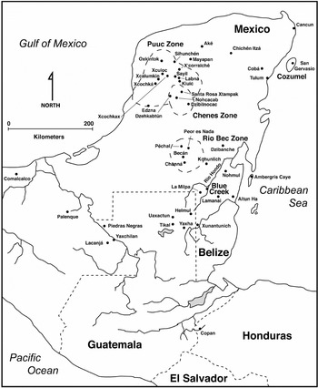
Location of Blue Creek.
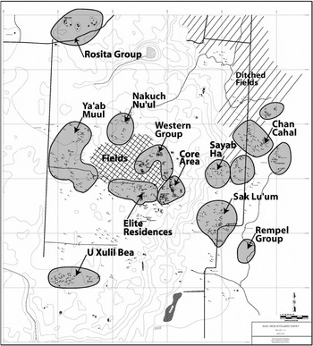
Components of the Blue Creek site.
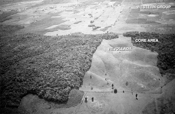
Aerial view of Blue Creek site core from the east.
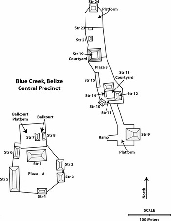
Plan view of Blue Creek core area.
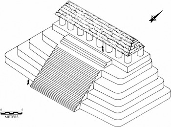
Reconstruction drawing of Structure 1-IV (drawing by David Driver).
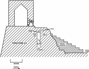
Profile of shaft and caches in Structure 4.
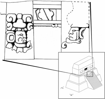
Masks on the front of Structure 9-IV (from drawings by Helen Haines).
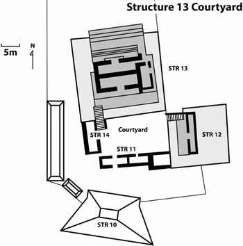
Plan view of Structure 13 Courtyard.
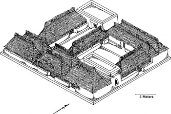
Reconstruction drawing of Structure 19 Courtyard (drawing by Robert Lichtenstein).
 You have
Access
- 18
- Cited by