1. BACKGROUND
The mandatory implementation of the Automatic Identification System (AIS) for shipping in 2002 and the relentless drive within the shipping community to introduce electronic navigation aids to merchant ships had the principal stated objective of improving safety by enhancing situational awareness. However, some of the doubts expressed at the inception of these initiatives regarding their likely success have been realised in that there is now a commonly held view that the general standard of bridge watch-keeping has been eroded leading to several serious collisions and groundings.
This paper reviews the various types and quality of electronic equipment fitted to the vessels during the past five years in order to assist the watch-keeper in the problem-solving process of collision avoidance and safe navigation. It argues that the perceived reduction in the core competencies of bridge watch-keeping have arisen due to the unforeseen effect of a human trait where the equipment has engendered over-confidence in situational awareness, encouraging individuals to take far greater risks than was previously the case where a good look out and safe speed were an intrinsic part of watch-keeping. Although training is important to ensure the correct use of electronic navigational aids it is has become clear that to address the human predilection to take risks it is essential to adopt a “back-to-basics” approach with an emphasis on the fundamental skills of watch-keeping such as a sound working knowledge of the Anti-Collision Regulations and basic navigation skills.
2. HUMAN ERROR AND LACK OF TRAINING
There is arguably a human trait which prejudices safety by taking shortcuts to achieve the desired outcome. Indeed there is a body of opinion which is concerned about the endorsement of checklists as the foundation of the safety management system. Many will cite the habitual ticking of boxes where a piece of paper can deliver confidence in the status of an operation which does not actually exist. The audit has similar constraints in that the individual can satisfy the criteria without meeting the required standards. A recent letter published in the Nautilus Telegraph from a seafarer reflects the commonly held view that “Standards are too variable. We have all been on ships passing such scrutiny when we know that they should not have”.1 In order to counter this condition it is necessary to engender a behavioural norm within the individual which recognises bad practise as a critical factor in compromising standards of safety within the industry.
The bulk owners' organisation Intercargo says its analysis of accidents and port state control results shows that human error and training issues are impacting as much on good owners as bad owners. It is concerned about the rise in the serious deficiencies uncovered by PSC inspections and a rise in the rate of ISM and training related deficiencies.2
This situation can only be rectified by a strategy to guarantee the training and experience necessary to deliver the core competencies which used to be the basis of mitigating risk in the shipping industry. This is contrary to current practise where, motivated by the drive to reduce crew costs, shipowners have readily substituted the fundamental skills of watch-keeping to a third party. In the shipping industry one such third party is electronic navigation aids that, unfortunately for the underwriters, can not be held to account.
3. MITIGATING RISK
The International Regulations for Preventing Collisions at Sea 3 ratified in 1972 provided a code by which the risk of collision is mitigated by a simple set of rules which dictate how ships manoeuvre clear of each other at sea. Simplicity is the key since these rules need to be clearly understood to allow proper and effective action to be taken to avoid a collision. Interpretation is also important since in more complex situations it is necessary to make an informed judgement of the correct action to be taken and to this end earlier generations of Master Mariners were expected to know the Rules verbatim. Rule 19 has been cited as one of the most poorly understood rules and there is a move to rewrite the Rules to address this shortcoming. However, there is a strong argument that insufficient emphasis is placed on this important Rule during training. When this is considered in conjunction with the confidence engendered in situational awareness by the high quality of modern radar and navigation equipments a situation can quickly develop in restricted visibility where the watch-keeper acts in a manner which is extremely dangerous.
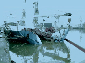
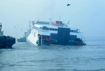
Two recent examples of this predilection to take risks are the collisions in poor visibility between ships on the Rivers Humber5 (see Figure 1) and Mersey6 (see Figure 2). Both are similar in that the respective ships were proceeding at speeds inappropriate to the prevailing conditions. As a consequence, by the time the officers with the con appreciated the seriousness of the situation and the risk of collision it was too late to take avoiding action.
Skagern alongside King George Dock, Hull (Courtesy of MAIB).

The Sea Express 1 is towed to safety after the collision on the River Mersey. Poor bridge team management was cited as a reason for the collision, however, it was arguably the fact that the Sea Express 1 continued her intended track irrespective of the thick fog, thereby getting so close to the Alaskan Rainbow that avoiding action could not be taken (Courtesy of MAIB).

The MAIB reports into these 2 accidents draw attention to the importance of effective dialogue with pilots and to challenge the decisions taken by pilots 4. However, this fails to acknowledge the undisputed fact that although authorities cite lack of cooperation and support as a critical factor in these accidents it remains the case that most crews relax and switch off once the pilot takes conduct of the ship. This is as much a reflection on the mix of nationalities which have no common training as to the poor standard of spoken English. Nevertheless, the fundamental cause of both of these accidents was due to excessive speed in that the person with conduct was manoeuvring the ship in thick fog as if the degree of situational awareness was similar to that in good visibility. Indeed it is not uncommon to hear watch-keepers agreeing green to green as noted in the incident on the River Mersey6 even though the vessels are not in sight of one another. VHF has been criticised for increasing the risk of collision by encouraging watch-keepers to agree actions that contravene the Rules.
It was assumed that AIS would mitigate this risk since one of the major causes of collisions had simply been that watch-keepers did not confirm by positional information that the vessel being talked to was the actual radar target.
4. LACK OF SKILLS
Prior to the introduction of modern electronic navigation aids the method of assessing a risk of collision was as stated in Rule 7 Risk of Collision 3. However, current practise would suggest that all available means amounts simply to using the radar and AIS to identify whether a close-quarters situation is developing. ARPA has become the primary tool by which all navigation and collision avoidance is undertaken. The human trait akin to the line of least resistance has meant that bad practises have become commonplace such as loading navigational tracks without checking that the track is actually safe or indeed the correct one. It is also possible to use the functionality of ECDIS to generate a reciprocal navigation track with the result that ships invariably meet head-on, not only in narrow channels, but also in open sea despite the customary practise that routes west should be displaced to the north. This is exacerbated by the fact that many watch-keepers have no understanding of great circle routes other than the calculations provided by GPS equipment. Another consequence of ECDIS is the tendency of ships to share navigational information and follow identical tracks with the result that ships remain in close proximity particularly in traffic separation schemes, colloquially referred to as waypoint-itis. The foundation of core competencies is a comprehensive training package that ensures a degree of practical experience for the individual so as to recognise bad practise and appreciate its critical importance to prejudicing safety. The introduction of electronic equipment has unwittingly compromised safety in allowing a commensurate reduction in watch-keeping standards due to a reliance on navigation aids as the principal means of safely conning a ship.
5. GPS
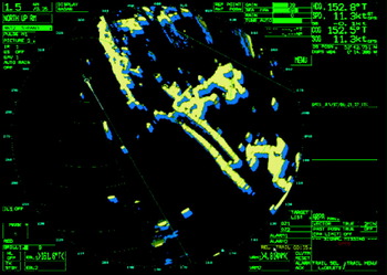
The modern bridge is driven by GPS. It provides the time constant and positional data for all equipment acting as the ground stabilisation for ARPA, navigational reference for ECDIS and the architecture for AIS. In bridge simulators the true vector derived from GPS information is used as the primary instrument for assessing the relative movement of a ship experiencing the effect of wind and tide. (See Figure 3). Indeed some would consider such modern training to be little more than a Playstation where the aim is to align the vector with the berth. However, the achilles heel of GPS is that its prediction algorithm is derived from historical positional data. Although this error is acceptable in open sea, extreme variation in currents and wind whilst in the confines of a harbour require the capacity of any system to anticipate and predict the set of a vessel and to date this can only be achieved by the human factor reflected in the experience and competence of a pilot. The marine environment is an intrinsic set of variables that are part of an equation that can not be solved by the linearity of a traditional mechanical model. Indeed it is this drive to replicate many of the processes on the bridge with the objective to improve situational awareness and assist the watch-keeper in problem-solving that has generated the complexity and diversity of equipments that has undoubtedly contributed to many marine accidents.
The Atlas Radar Pilot of the Samskip Courier with a typical PPI set-up of Relative Motion display with true vectors and relative trails. The situational awareness engendered by modern displays encourages speeds that are totally inappropriate given the condition of visibility.

6. THE INTEGRATED BRIDGE
The concept of integrating the navigation, propulsion and steering systems had the objective of greatly improving the working environment of the watch-keeper by eliminating the demands caused by a range of diverse, separate equipments. One multi-functional system would provide all of the information and functionality necessary to safely navigate a ship. However, the complexity of the bridge watch-keeping problem does not permit a simple task orientated analysis of a process which the design of software in support of a simple mechanical operation requires. As a consequence, in order to satisfy the multitude of variables which are an intrinsic part of the equation, the equipment has become too complex with many simple functions such as displaying relative vectors or off-centring the display requiring several drill-down menus.
Furthermore, gaining agreement from customers as to the exact user-requirement has created a staggering diversity in the functionality of equipment which when combined with the misplaced but understandable enthusiasm of software engineers to convert everything to the digital era has led to such extremes as using a PC based system to simply close a watertight door. In order to address the variables of the navigation process the systems have now achieved such a degree of complexity that only a very well-trained and experienced operator can safely use such equipment.
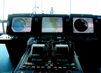
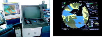
With regard to the Atlas NACOS product for the integrated bridge (See Figure 4) it is interesting to note that although several serious incidents have occurred during the past 5 years where vessels have suddenly applied excessive degrees of rudder angle that none appear to have been due to system malfunction, but operator error in that the equipment settings were not appropriate for the intended alteration of course or speed of the vessel at that time. A variation on the theme of the integrated bridge is shown in Figure 5.
The ATLAS NACOS integrated bridge system.

A variation on a theme. The ECDIS PPI on the right is correctly set-up to identify any datum discrepancies between the chart and the ground stabilisation of the radar display. A low-cost, but effective alternative is the chart display situated adjacent to the ARPA as fitted on the 30 year old passenger ferry Stena Europe. Separate equipments facilitate the comparison of information which is critical to safe navigation.

7. ECDIS
The drive towards a paperless bridge has stalled due to the lack of a commitment by the international community to produce and maintain an accurate electronic chart outfit to the S57 standard. This was hardly surprising since this situation is simply a reflection of that which existed with paper charts and publications. However, whereas many companies previously used UK Admiralty Charts as the industry standard this is no longer the case and a plethora of systems now exist many of which are of questionable quality. Indeed it is interesting to note that some national authorities appear to have relaxed the rules in endorsing Transas Charts as a legal substitute for paper charts even though it is not accredited by a recognised hydrographic office. Furthermore, it is clear that many crews are untrained in the use of electronic charts, particularly with regard to the importance of datums and accuracy. Many fail to recognise the importance of matching a GPS stabilised chart to navigational targets on the ARPA display, but simply navigate using the picture display on a PC.
Furthermore, AIS was introduced with the objective of enhancing situational awareness and, therefore, assisting a watch-keeper to take the correct action in order to avoid a close-quarters situation. However, in common with other initiatives it has exceeded its remit by facilitating a degradation in watch-keeping standards where some watch-keepers use AIS information for collision avoidance as a substitute for ARPA. It is also not uncommon to see navigational tracks on the display that pass the wrong side of buoys or across shoal water. The likely cause of this situation is a combination of a shift from training in traditional navigational skills such as visual bearings using a compass repeater and radar ranging with an emphasis on computer skills as an acceptable and far less arduous means of watch-keeping practice. This has severely degraded the standards by facilitating a significant shift away from the professional skills of watch-keeping that were the hallmark of previous generations.
8. A STRATEGY FOR TRAINING
It is clear that something must be done to address the increase in the number of navigational incidents which have undoubtedly been the direct result of a reduction in the standards of training and commensurate experience of the seafaring community. The drive to improve safety at sea by the introduction of electronic navigational equipment to enhance situational awareness and assist the watch-keeper has unwittingly compromised safety standards by reducing the core competencies that were demanded of previous generations and engendering the undesirable human trait to select the easiest option. To ensure the safety of navigation it is imperative that the shipping community acknowledge that the training and experience of watch-keepers are critical factors in mitigating the risk of collision and groundings. It is only through establishing a benchmark of underpinning professional competence throughout the international community that a watch-keeper can recognise the critical importance of maintaining the highest standards commensurate with having conduct of a ship and this can only be achieved by establishing the fundamental key skills of keeping a bridge watch during training.