Idea of exploration
The idea of a Polish national expedition to Greenland was first suggested by Aleksander Kosiba, an experienced polar explorer and member of the Danish geodesic expedition to Greenland in 1934. The proposal, which conformed to the philosophy of international activity in polar research, was greatly appreciated by the Geographical Institute at the University of Lwów (until 1945 the city was historically Polish, later it became Lviv in Ukrainian).
The main goal of the expedition was to undertake a comprehensive study of a fragment of the Greenland ice sheet edge and its foreland, focusing on a cartographic survey. The interdisciplinary research programme was undertaken in accordance with the principle of uniformitarianism and the results were used to explain the processes shaping the landscape in Poland during the Quaternary era. The expedition contributed to the growth in Polish economic interest in biological resources in Arctic waters.
The expedition fieldwork was carried out in western Greenland at the eastern edge of Arfersiorfik Fjord between Disko Bay in the north and Nordre Strömfjord in the south. The choice of the study area was dictated by the fact that the area had never been surveyed and by the continental climatic conditions prevailing over the fjord, which extends 200 km inland. The close vicinity of the ice sheet to the fjord created favourable conditions to implement the survey and take measurements. The ability to reach the area by boat was an additional important factor in selecting the site.
Organisation of the expedition
Scientific and organisational support for the expedition was provided by well-known Polish explorers and professors, Henryk Arctowski, Eugeniusz Romer and August Zierhoffer, numerous state institutions and private companies. The expedition aroused curiosity and concern among famous Danish explorers and scientists, including Lauge Koch, Olgards Storgaard and Harald Moltke. Significant support was provided by the Greenland government (Grönlands Styrelse), who issued a research permit and guaranteed places on a ship.
Grants and funds donated from companies helped to secure the participation of seven people on the expedition from May to September 1937 (Fig. 1). Four members of the expedition already had considerable experience in polar expeditions (Bear Island 1932/33, Greenland 1934, and Spitsbergen 1934 and 1936).
Commemorative photo of members of the 1st Polish Greenland Expedition with Inuit helpers in the main expedition base in Arfersiorfikfjord: from left to right, Stanisław Siedlecki with two Inuit, Rudolf Wilczek, Antoni Gaweł, Aleksander Kosiba, Antoni Rogala-Zawadzki, Otto Sandrön with unidentified Inuit, Alfred Jahn, two unidentified Inuit and Stefan Bernadzikiewicz (taken from original b&w photogrametric negative glass plate, archive of A. Kosiba, Institute of Geography and Regional Development, University of Wrocław).

The head of the expedition was its originator and main organiser Aleksander Kosiba, who was also responsible for glaciological research. Antoni Gaweł, a geologist from the Jagiellonian University in Kraków, conducted research on tectonics, petrography and mineralogy, and sedimentology of the ice sheet forefield and nutataks.
Alfred Jahn was responsible for geomorphological research and observations (thermal regime of patterned grounds, deglaciation and physiographic studies). Meteorological measurements and observations were conducted by Stanislaw Siedlecki together with Alfred Jahn. Botanical observations were carried out by Rudolf Wilczek from the Silesian Museum. The cartographic survey, using photogrametry methods, was undertaken by Antoni Zawadzki-Rogala, an experienced polar explorer and officer of the Geographic Military Institute (Wojskowy Instytut Geograficzny). Technical support and film documentary was the responsibility of alpinist Stefan Bernadzikiewicz.
The campaign and results
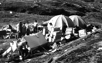
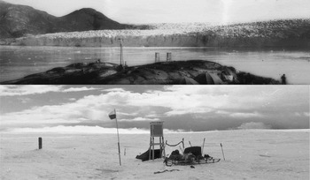
The first stage of the expedition began on 19 May 1937, in Gdynia, where the ship m/s Piłsudski transported six tons of equipment to Copenhagen. From there, the expedition sailed on-board the Danish ship m/v Disko to Greenland, reaching Egedesminde (present: Aasiaat) on Disko Bay two weeks later (10 June 1937). Here, the crew spent a few days renting a boat and recruiting local Inuit people to help with the expedition. The six hired people were led by Otto Sandrön, local Inuit teacher; the other participants were fishermen. The expedition reached the edge of the ice sheet on 16 June, after a boat trip of 170 km along the Arfersiorfik Fjord. The base camp was arranged at ‘Basis Point’ (latitude 67°50′ N, longitude 50°10′ W) after disembarkation with four tons of equipment, seven personal and two big military tents (Fig. 2). Two days later a meteorological station was put into operation. In a newspaper interview Aleksander Kosiba mentions a second station, of which there is no further detailed information (Figs 3 and 4). He probably had in mind the weather station established on 25 June at an altitude of 600 m above sea level on the ice sheet 25 km away and.
Main camp of the expedition in Arfersiorfikfjord (archive of A. Kosiba, Institute of Geography and Regional Development, University of Wroclaw).

Upper photo - front of Polonia Glacier in the Arfersiorfikfjord and the base camp of the expedition, with two meteorological screens and wind mast; bottom photo — weather station on the ice sheet (taken from original b&w 35 mm negatives; archive of A. Kosiba, Institute of Geography and Regional Development, University of Wroclaw).

Stanislaw Siedlecki and Stefan Bernadzikiewicz at the weather station on the ice sheet (taken from original b&w 35 mm negative; archive of A. Kosiba, Institute of Geography and Regional Development, University of Wroclaw).

Intensive research continued throughout the stay. The photogrammetric survey included 200 km2 of the inland ice margin zone and neighbouring areas. Antoni Zawadzki-Rogala fixed ten stabilised triangulation points, 32 control points and 29 stereophotogrammetric points, where he made 174 images in total (Fig. 5). He compiled seven maps based on the photogrammetric images (Kosiba, Reference Kosiba1938a). The first of these, entitled West Greenland marginal zone of the inland-ice near Arfersiorfikfjord (scale 1:50,000), covered an area of 370,000 km2 and was edited by the Geographic Military Institute in Warsaw in 1938. It was the first detailed map of this region (Fig. 6). The other maps were not published. Three of them covered the area of Glacier Polonia, two maps covered Nordenskiöld Glacier, one map included JP Koch Glacier. A methodological comment on the Polish geodetic survey carried out in 1937 in Greenland was published and printed by the Publication Section of the Polish Army in the East in Palestine during the Second World War (Zawadzki-Rogala, Reference Zawadzki-Rogala1944).
Aleksander Kosiba, Antoni Zawadzki-Rogala and two Inuit during geodetic survey.

Topographic map of the marginal zone of ice sheet in the Arfersiorfik Fiord area (left) and front cover of the methodological comment (copies from the original works, archive of A. Kosiba, Institute of Geography and Regional Development, University of Wroclaw).

In the first ever map of this region entitled The Polish expedition to give new names, 23 new names were approved by the Danish Government (that is, Polonia Glacier, Romer Mts, Mościcki Mts, Dybowski Lake, Geographical Union Glacier, Knud Rasmussen Range, Nordenskiöld Valley, Tycho de Brahe Lake, J.P. Koch Glacier). Unfortunately, these names no longer appear on maps of Greenland.
The planned stay in the fjord had to be shortened due to the early return of the ship m/v Disko to Copenhagen. The expedition returned to Egedesminde on 28 August and the crew reached Gdynia on 24 September.
Considering the shortened period of activity, the achievements of other members of the expedition were impressive. Rudolf Wilczek obtained a rich and valuable collection of herbarium, and collected pollen rain samples along the Greenland coast both during the sea trip and on land (Dubiel, Reference Dubiel1994; Dyakowska, Reference Dyakowska1948). The geology and physiography of the area was studied and information was collected about the morphogenetic processes that shape the landscape. The expedition collected unique meteorological data, which was useful to study the specific climate of the fjord and the impact of the ice sheet. Stefan Bernadzikiewicz made a 1,000 m tape of a documentary film. The expedition collected a rich collection of Inuit belongings, which were already becoming rare in daily life. They also established many cordial friendship with indigenous peoples, which allowed the scientists to understand local culture and customs, as described later in publications and memoirs of the expedition participants.
Brief information about the organised expedition and a short report were published in Polar Record (Kosiba, Reference Kosiba1937, Reference Kosiba1938a). After returning home, the members of the expedition published a number of reports in national newspapers and popular science magazines. Scientific publications include the abovementioned map by Zawadzki-Rogala (Reference Zawadzki-Rogala1938a, Reference Kosiba1938b, Reference Zawadzki-Rogala1944) and a paper by Jahn on the postglacial rebound of west Greenland coast (Jahn, Reference Jahn1938). Based on elevated abrasion terraces, Jahn reconstructed the postglacial development of the coast and determined the stages of glacial isostatic movement. Kosiba delivered a lecture on terminal moraines in Greenland at the 16th International Geographical Congress in Amsterdam (Kosiba, Reference Kosiba1938b).
Unfortunately, only part of the material and research results collected during the expedition were analysed before the Second World War, and most were lost during the war. A collection of photogrammetric plates, photographic films and some of the meteorological records held by Aleksander Kosiba in Lwów were the only research materials which were rescued. The map of the west Greenland marginal zone of the inland ice near Arfersiorfik Fjord has survived (Józefczyk et al., Reference Józefczyk, Korzystka, Migała and Piasecki2010). As have the botanical collection and pollen samples, which went to the Botanical Institute of the Jagiellonian University. The pollen samples were analysed by Dyakowska (Reference Dyakowska1948), who calculated the effective distance of pollen transportation to the ocean floor. This finding was important for future palynological and sedimentological studies (Groot & Groot, Reference Groot and Groot1966).
After 1945 several scientific briefs and extended papers were published. Aleksander Kosiba shared his reflections on the oscillations of the Nordenskiöld Glacier and pattern grounds (Kosiba, Reference Jahn1947a, 1947b). Alfred Jahn engaged in the study of glacial geomorphology and described rock fracturing, glacial microrelief of the ice-sheet forefield and talus deposits (Jahn, Reference Jahn1947a, Reference Jahn1947b). In 1948, Jahn published the results of his research on the physical properties of patterned grounds, including a review of contemporary views presented in world literature about their thawing and origin (Jahn, Reference Jahn1948). He also wrote two books promoting the nature of Greenland (Jahn, Reference Jahn1947c, Reference Jahn1969). A list of all the publications concerning the expedition was published by Kohler (Reference Kohler2014).
Epilogue
The fate of the expedition members was quite dramatic. Stefan Bernadzikiewicz, an excellent alpinist, then President of the Polish Mountaineering Club died in 1939 during the first Polish expedition to the Himalayas, the aim of which was the summit of Nanda Devi East. Antoni Zawadzki-Rogala fought in the Middle East (Iraq, Palestine) as a member of Polish Armed Forces during the Second World War. After the war he returned to Poland and worked in his profession. Rudolf Wilczek settled in Belgium after the war and worked for the Botanical Garden of Brussels. He studied flora of Central Africa and other regions. A total of 320 floral taxa from Africa were named after him (Kornaś, Reference Kornaś1986).
Antoni Gaweł, who later became a professor of geological sciences, continued to work at the Department of Mineralogy Jagiellonian University, where he had worked intermittently since 1927.
Post-war, the expedition members exerted great influence on the development of Polish polar research. Stanislaw Siedlecki led a Polish expedition to Spitsbergen during the 3rd International Geophysical Year 1957/58 and built a permanent year-round station, which still operates and is named in his honour (http://hornsund.igf.edu.pl/). He emigrated to Norway in 1966 and worked at the Norwegian Geological Institute in Trondheim until 1980. He returned to Poland in 1991. Alfred Jahn and Aleksander Kosiba, later professors of the University of Wrocław, created foundations for Polish polar research and educated dozens of their scientific successors, who built the teams involved in polar research (Stanisław Baranowski at the University of Wrocław, Gabriel Wójcik at the Nicolaus Copernicus University, Marian Pulina and Jacek Jania at the University of Silesia). A herbarium of 110 species of vascular plants from Greenland is still a part of collection of the Botanical Institute of the Jagiellonian University in Kraków (Dubiel, Reference Dubiel1994). This university has become not only an important centre for palaeobotanical research but also a leader in the study of contemporary flora of polar regions (Maria Olech). Thanks to Stanislaw Siedlecki and Antoni Gaweł, geology and geomorphology of the polar regions has also become a specialty of the scientific institutions in Kraków (Krzysztof Birkenmajer at the Polish Academy of Sciences, Zdzisław Czeppe at the Jagiellonian University, Andrzej Manecki at the AGH University of Science and Technology).
Acknowledgements
We would like to thank the family of Professor Aleksander Kosiba and Dr Maria Jahn, wife of professor Alfred Jahn, for the materials documenting the scientific effort of their close relatives during the expedition to Greenland in 1937. We also wish to thank our friend Dr Anthony J. Dore from the Centre of Ecology & Hydrology in Edinburgh who helped us with the English translation of the text.