Introduction
Inaugurating a new model of global power, the European colonization of the Americas began with the industrial-scale extraction of mineral resources. These processes have left long-lasting environmental and social scars across the American continent. They also leave spatial and material traces in the urban landscape: for example, they remain embedded in the morphology of Santo Domingo. While indigenous urban settlements existed in the region before the arrival of Europeans, Santo Domingo was the first city founded by the colonizers. Established in 1498, it became the political and economic seat of the Spanish colony of Hispaniola.Footnote 1 For two hundred years, it was a significant base of Spanish colonial power, the earliest urban site associated with the Atlantic slave trade. As Aníbal Quijano has written, colonial power had two fundamental axes: one was the ‘constitution of a new structure of control of labour and its resources and products’; the other was the ‘social classification of the world's population around the idea of race, a mental construction that expresses the basic experience of colonial domination’.Footnote 2 These systems legitimized the oppression of racial others to advance the colonial project. This article explores how the spatial and material construction of colonial Santo Domingo constituted and maintained social and racial structures of oppression. From this urban centre in the Caribbean, new systems of labour control and classification of racial difference supported processes of ecological extraction across the Americas. This process began with mineralogical extraction, with the mining of limestone to build the city itself.
Santo Domingo has been called the ‘cradle of blackness in the Americas’.Footnote 3 But discussion of racial exclusion and marginalization is mostly absent in histories of the city's architecture and planning. The use of decolonial theory in urban history provides a useful framework in the broader disciplinary sense to investigate these issues – for instance, scholarship on historical black urban spaces is abundant in the context of colonial North America and Africa.Footnote 4 Yet, although the social and economic aspects of labour and race have been explored in histories of Santo Domingo, little has been written about how these aspects intersect with urban space. Santo Domingo was laid out under the direction of Nicolás de Ovando, according to a strict geometry based on European precedent. This article argues that the intertwined categories of race and labour are manifested most obviously in the Santa Bárbara neighbourhood on the north side of the city. This neighbourhood is the first ‘informal settlement’ created by the new structure of labour brought by Europeans.Footnote 5 Santa Bárbara has been called ‘the first urban poor neighbourhood on the continent…where surviving Indians (Indio), mestizos and remnants of the first whites who arrived on the island lived’.Footnote 6 In this way, it was identified in economic and racial terms: here a new classification of racial otherness was developed and implemented.
Contained within, and controlled by, the walls of the original city, Santa Bárbara was where labourers mined the limestone from a nearby quarry that masons used to build the urban core. The settlement was also a significant site in the Atlantic slave trade. In Santo Domingo, the enslaved were distributed from the central market in Santa Bárbara. Their labour created enormous wealth in mines and plantations across the Americas, at the same time as the practice created immense human deprivation. When the church of Santa Bárbara was built in the mid-sixteenth century, the identification of this area as a separate district was complete. By the eighteenth century, it was recognized as an arrabal, a marginalized quarter associated with a racially distinct labouring class. While regulations were important in reinforcing racial exclusion, the built environment features there were also concrete representations of oppression.
Drawing on historical maps and archival documents, this article analyses the racial geography of colonial Santa Bárbara. This geography includes the close spatial and social relationships between colonial artisans, native Taíno, enslaved and free blacks and mestizos; an association that contributed to the emergence of Dominican culture as it exists today. Consideration of this urban site elucidates the constitutive connection between ‘race’ and ‘labour’ that Quijano has theorized. For Quijano, racial otherness, blackness, was created as part of the founding of ‘America’ (the Latin American colonies) and its economy, as a way to describe those who perform unwaged labour, or whose work is strictly controlled. This category of ‘blackness’ encompasses diverse geographic and cultural identities, including members of indigenous groups, enslaved peoples from different parts of Africa and migrants from other places engaged in manual labour. In Santa Bárbara, a diverse social group participated in the work necessary to build and maintain the city. This neighbourhood is identified with slavery through a particular building now lost, known as La Negreta. But in subsequent histories, Santa Bárbara is more often associated with poverty and social exclusion rather than being identified as solely ‘black’. The article concludes by examining how Santa Bárbara's racial history is remembered and memorialized today.
Urban ecologies of extraction and exclusion
The origins of Santo Domingo can be traced to the late fifteenth century. From the start, the city was envisioned as the centre of trade between Europe and the Americas. Six years after Christopher Columbus claimed the island that he called La Española (Hispaniola) for Spain, a new city began to appear on the south coast, adjacent to existing Taíno villages. Founded by Columbus’ brother Bartholomew, Santo Domingo is the oldest seat of European power in the Americas. The primary historical sources on the foundation of the city are Bartolomé de las Casas and Gonzalo Fernández de Oviedo, two historians who lived in Santo Domingo during its early years.Footnote 7 From their writing, we know that the site was chosen because the Ozama River was deep enough for ships to navigate, providing a good port. The site was also close to the all-important gold mines and therefore a suitable location for offices associated with the colonial administration. Bartholomew Columbus founded the first settlement on the east bank of the river in 1498, but it was soon destroyed by a hurricane. This unfortunate event inspired the new governor, Nicolás de Ovando, who arrived from Spain in 1502 accompanied by 2,500 settlers, to choose a new site on the west bank of the river, where the city stands today. Outside the city, Ovando established the legal system of encomiendas, through which the Spanish crown expropriated and distributed land among the colonizers. It also granted them ownership of a number of indigenous people to work the land through forced labour. This system created inequality among the colonizers themselves, with high-ranking Spaniards given the best properties, and those with less social standing, smaller plots in more inferior locations.Footnote 8 The repartition of these lands produced spatial segregation along social – and by default, racial – lines. The city of Santo Domingo reflected this spatial inequality in its urban structure.
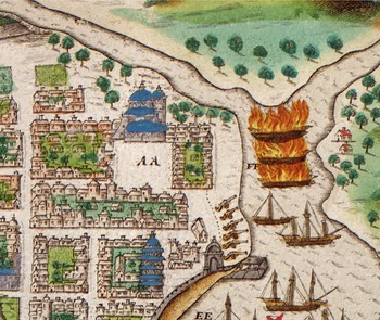
The idealized form of the first colonial city may be seen in maps dating to the end of the sixteenth century. These include Giovanni Battista Boazio's map made in the 1580s. Depicting Sir Francis Drake's English armada capturing Santo Domingo in 1586, this is one of the oldest full representations of the city, made 80 years after its founding (Figures 1 and 2). Projecting an image of power and domination, this map shows a fortified city bounded by defensive walls, by cliffs facing the Caribbean Sea and by the Ozama River. Depicted as a geometrical whole, the city is ordered and complete in itself, in strong contrast with the surrounding landscape of hills, plains and scattered villages of the Taíno, the aboriginal peoples of the main Caribbean islands. In his history, de Oviedo commented on the differing spatial geographies of the island, comparing the ‘Ciudad de Santo Domingo’ (city of Santo Domingo) with the ‘pueblo de Indios’ (native towns) made up of different chiefdoms; and villages such as ‘Villa Buenaventura’, ‘Villa de San Juan de la Maguana’ and ‘Villa de Puerto Plata’.Footnote 9 The city's defensive walls were designed to maintain this separation, and to safeguard it from attack by pirates and by other colonial powers. Within these boundaries, the city is shown as a grid of regular blocks, anchored by a cathedral sitting in the centre of a plaza. To the east, battlements line and protect the port. To the north-east, the presence of a smaller square suggests a peripheral neighbourhood.
Map of Santo Domingo in the 1580s. G. Battista Boazio, ‘Boazio – Sir Francis Drake in Santo Domingo 1585’, Library of Congress, Jay I. Kislak Collection, 1589.

Partial view of Figure 1, showing Santa Bárbara within Santo Domingo. Zooming into Boazio's representation, the settlement of Santa Bárbara is portrayed with its own church and plaza (AA), most likely where slaves were sold.

In his urban planning, Ovando, a former soldier, was influenced by a telling precedent, the Spanish city of Santa Fe de Granada, the military town from whence the Spanish organized the culmination of the ‘Reconquista’, the expulsion of Muslims from the Iberian Peninsula. Modelled on classical Greek and Roman cities, both Santa Fe and Santo Domingo are structured following a grid pattern with streets intersecting at ninety degree angles. As with many cities based on idealized geometric plans, the grid of Santo Domingo is not entirely regular as it adapts to the topography of the site.Footnote 10 This urban form served as the model for later urban developments across the continent.Footnote 11 As Paul Barrett Neill has noted, these cities ‘contributed to the construction of early modern American identities, early colonial labour systems, and relationships between town and countryside’.Footnote 12 These towns were political centres, places where the colonial administration instituted legal and other regulatory regimes of control. With their construction, the Spanish legitimized their dominance of the territory, using urban spaces and buildings as symbolic and institutional elements of power and superiority.
Neill describes ‘Ovando's stone city’ as a self-conscious representation of elite identity.Footnote 13 Arranged around the central plaza, most public buildings were built of stone and followed the late gothic, renaissance and baroque styles popular in Europe.Footnote 14 Supporting the narrative of the city as the urban symbol of colonial power, cartographic representations depict the ideal more than the real. Boazio's map shows a Santo Domingo far more coherent and consistent than the city on the ground. As Frank Moya Pons has described, early maps show a vibrant city occupying the whole intramural space; however, there is evidence that not all the blocks were developed.Footnote 15 It was not until the end of the eighteenth century that the north-western section of the city's defensive wall was completed. In fact, Luis Josep Peguero's map from 1762, constructed from direct observation of the city, highlights several empty lots (Figure 3).Footnote 16 This map also shows the imperfect geometrical order of the city, in contrast with idealized representations such as Boazio's. Likewise, early maps omit information about ownership and material construction, erasing significant differences between the various parts of the city. For example, the centre of the city around the cathedral of Santa María la Menor, constructed between 1521 and 1541, was where many of the colonial elite resided. The stone used to construct these buildings was extracted from a quarry to the north of the urban core where an informal settlement for quarry-workers emerged. The formal city owed its existence to an informal settlement on its northern perimeter, a settlement with quite a different character.
Plan of the city of Santo Domingo with an enumeration of its streets. Significant here are the several empty lots, contrasting the idealized version of previous maps. L.J. Peguero, Historia de la conquista de la Isla Española de Santo Domingo trasumptada el Año de 1762, vol. II (Santo Domingo, 1762), 15.

While Boazio's map showed no topological variation, the north-western defensive wall crossed a significant rise. This variation may be seen in an 1805 map, which shows the topography of the city, and the northern edge of Santa Bárbara hard up against a hillside (Figures 4 and 5). At this point, where the notional wall met the river, miners and masons extracted the limestone used to construct the city walls and the earliest buildings, including the cathedral, the first hospital and the first monastery in the Americas, the convent of San Francisco built on the hill overlooking the town.Footnote 17 Nearby, these workers formed a residential settlement. Though part of the intramural city, this is the only section depicted in Boazio's map with its own church and identified with its own name. This community of about seven blocks, known originally as barrio de los canteros (the stonemasons’ neighbourhood) was by the end of the sixteenth century called barrio Santa Bárbara after the church constructed there.Footnote 18 Fr. Cipriano Utrera, a Catholic priest who did extensive research analysing archival material from the Archivo General de Indias (General Archive of the Indies, or AGI) in the early twentieth century, wrote that the neighbourhood was formed spontaneously because of its proximity to the quarry.Footnote 19 A recent article suggests that by 1509 the settlement had expanded to house the soldiers who safeguarded the nearby Alcázar (fortified palace) of Christopher Columbus’ son Diego, who replaced Nicolás de Ovando as the island governor around that time.Footnote 20 In this way, although contained within the city walls, Santa Bárbara was not part of the elite centre with its stone buildings and houses. Much later described as a marginalized district, or arrabal, in this period it was a vital contributor to the enterprise of the colonial city, the engine of the urban machine.
Plan of the siege of Santo Domingo, by Dessalines, leader of the revolt. J. Dessalines, ‘Plan du siège de Santo Domingo par Dessalines, chef des révoltes de St. Domingue, forme le 15 ventôse et levé le 8 germinal an 13’, Library of Congress, Geography and Map Division (1805), available online, www.loc.gov/item/00561857/.

Enlargement of Figure 4, showing hilly topography north of Santa Bárbara.

While histories of Santo Domingo and its architecture do not focus extensively on Santa Bárbara, scholars from various disciplines have noted the importance of mining for the formation of the barrio; their studies highlight the material and social dichotomy between the settlement and the rest of the city.Footnote 21 From its origins, Santa Bárbara was a site of inequality and marginalization. The lowest members of the colonial class, the wage-earning miners, masons, carpenters, soldiers and artisans who lived in Santa Bárbara, were not gifted plots of land as members of the colonial elite were.Footnote 22 Because of its location near the port, the neighbourhood also housed sailors and dockworkers, along with a number of inns and brothels built precariously along narrow streets, with little formal planning or solidity.Footnote 23 Residents lived in small houses called bohíos, with walls made out of adobe or wood, dirt floors and ceilings made out of palm thatch. Though modified, these bohíos were similar to the homes of the native Taíno, from whose language the name was taken (Figure 6).
Original bohío typology (left) and evolution into urban space (right). De Oviedo's drawings introduce the Caney (rounded structure) where common Taínos lived and the bohío (rectangular structure) where the Caciques (Taíno chiefs) lived. The bohíos in Santa Bárbara in the 1930s resemble the original built with palm wood and with a thatched palm roof. G.F. de Oviedo, Historia general y natural de Las Indias, vol. III (Madrid, 1853), 634; AGN, documented in E. Prieto Vicioso and V. Flores Sasso, ‘Barrio de Santa Bárbara: primer asentamiento informal del nuevo mundo’, Intus-Legere Historia, 14 (2020), 151–68.

Contrasting with the formal city, Santa Bárbara was an urban and cultural ‘in-between’, utilizing the architecture of the indigenous people to house the lowest ranks of urban colonizers. It should be noted that the bohío remained a typical house structure for many rural and urban poor Dominicans into the early twentieth century.Footnote 24 In colonial times, this housing typology differed significantly from the stone houses in the formal city such as those built on the prominent Calle de las Damas, the first European street in the continent, where many of the city's elite resided. As Ponce Vázquez has written, these houses were ‘built with enslaved native and African enslaved labour and [had] beautiful stone carvings and coats of arms decorating their facades’.Footnote 25 In a way, an extreme architectural contrast contributed to a sense of domination over the marginal, informal site where stonemasons, labourers and soldiers lived.
The process of ecological extraction that began with mining the stone to build the fortifications and buildings of the city continued with the industrial-scale importation of enslaved peoples from across the Atlantic. Distributed across the continent, they built new cities, worked in gold, silver, copper and other mines, and on sugar, coffee, ginger, cotton and tobacco plantations.Footnote 26 From the earliest period, Santa Bárbara was closely associated with slavery and the slave trade, beginning with the Taíno population. After the Spanish crown prohibited this practice under the encomienda, replacing it with a serf-like system, colonialists turned to a much larger scale enterprise to meet the growing need for forced labour. Slaves were transported first from Spain and then from Africa, the former called ‘Ladinos’ as they spoke Spanish and knew the Iberian culture and the latter called ‘Bozales’. Santa Bárbara was a major slave distribution centre for the rest of the Americas. But some stayed in the city. Archival documents from 1538 indicate that colonial authorities used enslaved peoples to work on the construction of the city's defensive walls and significant buildings, including the main cathedral.Footnote 27
Describing the design and construction of Washington DC, Mabel O. Wilson has written, ‘the law, violence, urban geography and architecture worked together to forge a set of structures and a landscape of inequalities’.Footnote 28 The same was true of colonial Santo Domingo, three hundred years earlier. However, the effects of slavery on the city's urban identity and physical make-up have yet to be fully explored by urban historians. It is important to note that the long-lasting impacts of slavery in Hispaniola extend far beyond Santo Domingo. However, our focus here is on Santa Bárbara, to show that the geography of slavery includes not only plantations and mines but also the city itself. Racial and spatial marginalization and exclusion were mutually reinforcing in colonial Santo Domingo. On the one hand, legal regulations controlled the behaviour and movement of slaves and free blacks.Footnote 29 On the other hand, specific buildings and physical spaces were constructed for the exclusive practice of slavery. In Santo Domingo, as in other urban centres, some of these spaces were all but invisible, embedded within, or annexes adjacent to, the homes of the ruling class. Others, the most public, were located in Santa Bárbara, again reinforcing the neighbourhood's separation from the activities and identity of the formal city.
La Negreta and the church of Santa Bárbara
Historians are divided about the first time that slaves were introduced to the island of Hispaniola.Footnote 30 Official documents describe the presence of African slaves in the city as early as 1503.Footnote 31 From original manuscripts of communications between the elites of Hispaniola and the Spanish crown, kept in the AGI, we know that in 1505 Ovando was successful in petitioning for more slaves to work in the island's gold mines.Footnote 32 The first official licence to import slaves from Africa was granted by Charles I in 1518.Footnote 33 The king granted 5,000 licences initially, and the trade brought thousands of men, women and children to Santo Domingo. The first slave ships that arrived directly from Africa came from what is now São Tomé and Príncipe and the Cape Verde islands. Later, they would come from other parts of West Africa including Congo, Senegal, Angola, Gambia and Sierra Leone.Footnote 34 Santo Domingo was soon a central hub in the international slave trade. During the first decades of colonization, it became a supply centre for slaves for Central America and Tierra Firme (South America and Mexico) and a processing and trading centre for the commodities extracted there. Nowhere in Santo Domingo was the dependency of colonization on slave labour more evident than in Santa Bárbara. Historical accounts show that enslaved peoples and free blacks would live in Santa Bárbara for at least three hundred years, and social structures based on race and labour continued to play an essential role in defining the neighbourhood long afterwards.Footnote 35
For centuries, one of the primary structures in Santa Bárbara was a warehouse-type building designed to guard or ‘store’ slaves. The use of such facilities became a common practice in the Spanish and Portuguese colonies in the Americas.Footnote 36 They were known in Spanish as galpones, barracones, chozas or rancherias; and in Portuguese as senzalas.Footnote 37 After being transported across the Atlantic in horrifying conditions, slaves arriving in Santo Domingo's port were received as merchandise by the local authorities. The historian Larrazábal Blanco offers one of the best descriptions of the route they took once in the city:
Already on land, they were destined for the galpones or warehouses prepared intentionally for them. This was followed by the palmeo or taking the necessary measurements such as height, and assessment of general complexion. Then the carimbado, which consisted of marking some part of their bodies with a red-hot metal stamp called a carimba, as is still done to cattle…In the city of Santo Domingo the first galpones for slaves, that was also the market site, was probably located by the Ozama River close to the Aterranazas or a little further up-shore. Later this site was transferred to the parish of Santa Bárbara, to a place that was later known by the name of La Negreta.Footnote 38
From these warehouses, slaves were usually sold individually in credit-based auctions. A document from 1575, for example, describes the sale of several slaves of different ages which took place on Tuesday, 16 December.Footnote 39 The early galpones Larrazábal Blanco refers to have also been described as ‘Royal warehouses’, indicating that the barracks used to house slaves before they were sold, and the process of the sale itself, were under the direct control of colonial authorities.Footnote 40 It is likely that the enslaved were already familiar with these architectural typologies of oppression, having been incarcerated before transportation across the Atlantic. It is possible that La Negreta had similarities to the factorías and barracones built on the African continent in places such as Sierra Leone and Senegal, which are wooden-framed structures with thatched rooves (Figure 7).Footnote 41 Like these examples, the building in Santa Bárbara was no doubt of significant size as it housed dozens and perhaps hundreds of slaves at the same time. The scale of this enterprise was astonishing: archival colonial documents suggest that ‘blacks have been shipped and are shipped every day to the Española island’.Footnote 42 Recent estimates of the number of people forcibly transported from Africa (and their descendants) living on the island in the 1540s range between 12,000 and 30,000.Footnote 43 Many thousands more were transported to other places.
Spanish slave barracoon in Sierra Leone, 1849 (left) and Portuguese Feitoria (factory) in the early eighteenth century in Angola (right). Illustrated London News (1849), 237; IFAN historical museum, Gorée Island, Senegal, in J.D. Edwards ‘Unheralded contributions across the Atlantic world’, Atlantic Studies, 5 (2008), 161–201.

While its size, form and exact location remains unknown, archival documents place La Negreta in Santa Bárbara, close to the Ozama River port.Footnote 44 The market and the building have not survived, but their memory persists in oral tradition and documentary fragments.Footnote 45 Documents in the Archivo General de la Nación (Dominican National Archives, or AGN) confirm the existence of a place called La Negreta as there are records of a land dispute in the 1800s near a place with that name.Footnote 46 An early reference to La Negreta comes from Libro Becerro de Santo Domingo, a book used in the eighteenth and nineteenth centuries to record rental details of houses across the city. In a thorough analysis of this book, which is kept in private archives by historian Raymundo Manuel González de Peña, Moreta Castillo has observed that the book permits the reconstruction of the streets in colonial and post-colonial Santo Domingo. Eighteenth-century notes in this book mention the existence of the Calle Principal de Santa Bárbara (Santa Bárbara Main Street) as well as Calle de Las Negreta (Las Negreta Street).Footnote 47 This book is the oldest written document that mentions the name of this street. A map from 1882 also includes a street of this name in front of the church of Santa Bárbara (Figure 8). The fact that a street was named after this building suggests that it was an important urban feature in the quarter.
Map of the City of Santo Domingo in 1882. In the top right corner – in front of the Santa Bárbara church – there is a street called ‘La Negreta’. This suggests that the building was located near there. It is also interesting to note how the intramural colonial city remained the main urban footprint over three centuries after its foundation. H. Tomasset, ‘Plano de la Ciudad de Santo Domingo’, Sociedad Dominicana de Bibliófilos (1882).

The colonial model of power solidified by slavery did not go uncontested. Both indigenous people and people transported across the Atlantic resisted structures of enforced labour in various ways. Famous among the ‘rebellious’ Taínos was Enriquillo, son of a powerful Cacique (chief), who fought the colonizers for 12 years.Footnote 48 But while the indigenous population was small, the number of imported labourers was growing. Already in 1527, King Charles V worried about the large population of slave labourers compared to colonizers, which ‘could be the cause for some unrest or uprising of the said blacks seeing themselves powerful’.Footnote 49 In response, he mandated the transportation of enslaved women to Hispaniola: the logic was that forming a family would make slaves more compliant. Also, legal ordinances were set in place to direct slave-owners’ responsibilities and to ‘regulate’ the behaviour of both enslaved and so-called free blacks.Footnote 50 Colonial authorities dealt with any uprising or violation of these ordinances brutally and in public: La Picota, a tall column-like element was erected in the centre of the city's Plaza Mayor, next to the cathedral (Figure 9). Standing until 1864, this was the site where slaves who had violated the law were lashed, and in some cases executed.Footnote 51 While La Picota was not located in Santa Bárbara, it has remained vivid in the city's collective memory. Alongside La Negreta and the slave market plaza, it was an urban expression of the city's early dependence on slave labour, and the violence used to maintain it.
La Picota in Columbus Park (originally Plaza Mayor) in Santo Domingo. The column-like element can be seen in the top right corner of the drawing (left) and on the right corner of the photograph (right). Left: C.B. de Quirós, ‘La Picota de Santo Domingo’, Boletín del Archivo General de la Nación, 111 (2005), 25–7. Right: photograph from 1860 gifted to C.B. de Quirós in 1943, published in a new version of ‘La Picota de Santo Domingo’, compiled in B.C.B. de Quirós, Una pluma en el exilio. Los articulos publicados por Constancio Bernaldo de Quirós en República Dominicana (Santo Domingo, 2009), 99.

La Negreta, La Picota and the Santa Bárbara slave market are sites of significant value to the city's urban and architectural history, even if in the case of La Negreta the exact form, dimensions and location are unknown. As in other cities across North and South America, these are ‘sites that are hidden in plain sight to those without knowledge of their history’.Footnote 52 But if La Negreta, La Picota and the slave market are now invisible, another monument built in the early colonial period survives as a testament to Santa Bárbara's urban alterity. Nothing has contributed more to the identity of the neighbourhood than the church built there soon after the city was established. Indeed, one of the main arguments for considering this district as a distinct settlement within the colonial city is that it was the only intramural neighbourhood with its own church.
The church of Santa Bárbara has been almost continuously rebuilt over five centuries. While the exact date of its foundation is unknown, it may have existed in some form as early as the 1520s. According to Utrera's account, this original church must have been ‘impoverished’ and was probably destroyed in one of the many earthquakes that affected the city.Footnote 53 A recent paper argues that it may have been built between 1528 and 1534 under the direction of Sebastián Ramírez de Fuenleal, fourth bishop of Santo Domingo (1527–38).Footnote 54 The paper also claims that the current church, made of stone, brick and rammed earth, was begun in 1573 (Figure 10). Utrera wrote that the new church was needed because of an increase in the local population.Footnote 55 However, we must treat his words with caution because, as a Catholic priest who needed the permission of the Santo Domingo bishop to publish his work, his writing may have been biased.Footnote 56 The sociologist Dagoberto Tejeda – a prominent member of the Dominican Academy of History – has argued that the construction of the church of Santa Bárbara meant that the city's elite did not have to share mass with slaves at the city's main cathedral.Footnote 57 If correct, this fact suggests that the Catholic church participated in the direct policing of behaviour and the indirect segregation of the community. As the second church built in Santo Domingo, Santa Bárbara upheld and reinforced labour and racial disparities within the city.
The church of Santa Bárbara c. 1930s. ‘Iglesia de Santa Bárbara Ciudad Trujillo Sto. Dgo. RD’, Archivo General de la Nación.

The arrabal
As the Spanish developed new colonial territories, Santo Domingo lost its importance as the leading city in the Americas. Its role as a significant trading centre lasted less than three hundred years. By the early seventeenth century, both Hispaniola's sugar cane plantations and its part in the Atlantic slave trade were in decline as other Caribbean ports such as Havana gained in prominence. Over time, the collapse of the plantation system in Hispaniola meant that slavery became a mainly urban institution.Footnote 58 These new socio-economic conditions created much closer interactions between different races and classes across the island, leading eventually to a well-established narrative of national exceptionalism in what is now the Dominican Republic. According to this narrative, present-day Dominicans define themselves not in racial terms, but in terms of dominicanidad (‘Dominicanness’), where a common identity is conferred through language, religion and customs.Footnote 59
However, although the polarized racial categories that are present in other North American, Latin American and Caribbean cultures are less apparent in the Dominican Republic, the divide between the formal and the informal city, the city of power and the city of labour, has been preserved. Economic decline after the sixteenth century meant the physical growth of Santo Domingo was retarded: the city did not experience significant urban development in centuries. The intramural city created in the 1500s continued to define and contain the population until the mid-1800s (Figure 11). With its early colonial form mostly unchanged, the urban structure of the port district of Santa Bárbara was preserved, even as its importance in the city's economy lessened significantly. Domingo Pantaleon Alvarez de Abreu, bishop of Santo Domingo from 1738 to 1743, described the church and settlement in the following way:
There is also in the city a parish named Santa Bárbara, with separate jurisdiction from the cathedral; it has its main priest, and major sacristan and 7 other priests, 300 neighbours, 1,184 people, and 140 of these are slaves. The church is poor with six altars and two chapels; with a significant lack of ornaments, but one of the priests has dedicated himself to that of the ‘Amparo’, so that one is more decent than the rest.Footnote 60
Evolution of cartographic representations of Santa Bárbara within the intramural city showing the church, the plaza and the connection to the port. From left to right (top): J.T. Bry, ‘View of Santo Domingo under siege, 1585–1586’, Prints, Drawings and Watercolors from the Anne S.K. Brown Military Collection (Brown Digital Repository, 1599); ‘Plan de la Ville Espagnole de S. Domingue dans l'Isle de ce Nom’, in J. Chez Checo (ed.), Imágenes insulares: cartografía histórica Dominicana (Santo Domingo, 2008), 142; T. López de Vargas, ‘Plano de la plaza y ciudad de Santo Domingo, capital de la ISLA Española’, ibid., 225; A. Montanus, ‘Urbs Domingo in Hispaniola’, De Nieuwe en Onbekende Weereld: of Beschryving van America en 't Zuid-Land (Amsterdam, 1671); D.F. Gerónimo de Pineda, ‘Plano de plaza de Sto. Domingo, capital de la Ysla Española situada en la desembocadura del Río Ozama’, in Checo (ed.), Imágenes insulares, 159; H. Tomasset, ‘Plano de la Ciudad de Santo Domingo’, Sociedad Dominicana de Bibliófilos (1882).

This passage suggests that the church and the settlement – as a separate jurisdiction from the rest of the city – continued to be impoverished. Although archival records show that Santa Bárbara became home to many free blacks, the bishop's account of 140 slaves amongst the parishioners suggests the continuity of slavery in the settlement up until the eighteenth century.Footnote 61 In this way, the neighbourhood continued to house the lowest socio-economic groups of the city, perpetuating its precarious urban condition.
In 1786, Antonio de Alcedo was the first to explicitly describe Santa Bárbara as an arrabal. In his Geographical-Historical Dictionary of the West Indies or America, he pronounced the core of Santo Domingo as having ‘very good buildings’, a ‘benign temperament’ and ‘a lot of commerce’, contrasting with a poor arrabal, the site of a secondary church.Footnote 62 Similar to the word ‘suburb’, the Spanish term arrabal originally described peripheral urban populations. At the beginning of the fifteenth century, dictionaries defined arrabal as a site occupied by people without plots in the city centre.Footnote 63 However, the term evolved into a derogatory spatial category. By the sixteenth century, it described settlements that were to some extent marginalized. The term was often used in the colonial period for sites of indigenous or slave populations.Footnote 64 Historically it describes areas not compliant with city regulations and plans: places of lawlessness and lax morals.Footnote 65 It is currently associated with ‘ill-fated’ or impoverished neighbourhoods.Footnote 66 The word arrabal was used several times in colonial documents to describe the settlement of Santa Bárbara, emphasizing its spatial exclusion from the administrative centre. Sited between the quarry and the port, Santa Bárbara began as a vital source of the materials and labour that built the city. Less than three hundred years later, it was considered inferior and unimportant.
The slave market, La Negreta and the church of Santa Bárbara were significant features of the built environment that contributed to the stigmatization of the settlement of Santa Bárbara, material markers reinforcing the distinct structures of labour and race in colonial Santo Domingo. While the church remains, buildings and spaces associated with slavery exist only in fragmented archival documents, and in the city's collective memory. But in this regard, these spaces have acquired agency: although no longer materially present, they exist through stories and in oral tradition. In this way, they are constant reminders of the inequality experienced by oppressed social groups, and they continue to motivate the fight to end racial discrimination and socio-economic injustice.
Remembering colonial Santa Bárbara in the twentieth century
There was a period when Santa Bárbara was not considered an arrabal, a barrio, a marginal district. After the independent Dominican Republic was formed in 1844, a gradual transformation of the settlement began, peaking in the first two decades of the twentieth century. The first change was a demographic one: attracted by its convenient location close to the port, and the charm of the ‘old stonemasons’ neighbourhood’, prominent members of the Dominican society began to move there, including doctors, merchants and politicians.Footnote 67 The appearance of the commercial bourgeoisie brought a series of changes to the traditional appearance of the neighbourhood, resulting in the alteration of an urban fabric that had remained largely intact for more than three centuries. New buildings were constructed, and the historic sixteenth-century fabric of wooden bohíos with thatched gabled roofs was interspersed with reinforced concrete republican-style buildings.Footnote 68 Modern elements of the formal city were incorporated into the urban fabric for the first time, including sidewalks and drainage systems. The neighbourhood became a vibrant district. No longer perceived as undesirable, it became an intrinsic part of Santo Domingo's expansion into a modern city.
However, this period did not last long. Under the Trujillo dictatorship, the city's trading sector gradually lost its importance. This economic decline resulted in the abandonment and progressive deterioration of Santa Bárbara, and its re-marginalization. Poor families started reclaiming the abandoned buildings to be closer to the opportunities offered by the city. Though Cyclone San Zenón destroyed much of the community in 1930, it was largely rebuilt with modest wooden-framed dwellings.Footnote 69 Photographs of the neighbourhood taken in the 1930s illustrate the poor state of these buildings: many built precariously on the remains of the old quarry (Figure 12). While most of the colonial zone has undergone significant improvements in the last few years, Santa Bárbara remains marginalized. A barrio marginado, it sits in stark contrast with the rest of the UNESCO-recognized Ciudad Colonial that is a desirable tourist destination complete with luxury hotels, restaurants and shops housed in historic sixteenth-century buildings.
This photograph shows the steep topography of the district, derived from its origins as a quarry. M.A. Martínez Paulino, ‘Ruinas del fuerte de Santa Bárbara’, Archivo General de la Nación, n.d., DO AGN 036.

Though short-lived, the early twentieth-century transformation of Santa Bárbara had significant symbolic repercussions. When the Ozama Bridge and a new avenue, Av. España, was built in 1917 to connect the east and west parts of the city, the remains of the infamous outdoor slave market and warehouse, La Negreta, were destroyed (Figure 13).Footnote 70 The construction of the Ozama Bridge and the Av. España resulted in the demolition of the remains of the infamous outdoor slave market and warehouse, La Negreta. The street commemorating La Negreta was renamed in honour of General Gabino Puello who, alongside his brothers José Joaquin and Eusebio, were the only prominent black members of the Dominican war of independence.Footnote 71 However, though erased, these sites live on in cultural memory. In the 1930s and 1940s, literary descriptions of Santo Domingo recorded stories about a building known as La Casa del Diablo (the house of the devil). According to historian Luis Alemar's 1943 account, some ruins of this ancient building had existed in recent memory:
[T]he first street, of little extension, to the Northwest of the city, is quite old and is now named General Gabino Puello. Its primitive name was ‘La Negreta’, being the origin of that name, according to tradition, the existence of a building there for the guard of black slaves, still showing some ruins at the end of the street…and that the community designates with the name of the ‘house of the devil’.Footnote 72
Photograph showing the Santa Bárbara church in the 1930s and the new Avenue in front of it, probably destroying the site of the slave market plaza. L. Mañón, ‘Iglesia de Santa Bárbara’ (1930–35), Archivo General de la Nación, DO AGN 036.

According to tradition, Alemar wrote, in the street where this building was formerly located, neighbours would hear the lamenting of ghosts in chains.
It is not unusual for places associated with slavery to produce legends and myths involving ghosts. These imaginaries of colonial oppression are often embedded in urban space and recounted in popular narratives.Footnote 73 Regarding La Negreta, while the building is gone, it is preserved in oral histories and folk stories. Passed down through generations, these stories are the only way that descendants of African slaves can ‘communicate’ with their ancestors in Santa Bárbara. In this way, places such as La Negreta are extremely important as cultural landscapes of memory where ‘ancestral forces might be mobilized to enhance one's own or collective wellbeing’.Footnote 74 Memories of these buildings highlight the importance of Santa Bárbara to the contemporary identity of descendants of historically marginalized groups.
UNESCO has held several events in Santa Bárbara to commemorate the histories of slaves in Santo Domingo. Held in 2008, one of these events was the first Encuentro de Musica Ancestral La Negreta (La Negreta's Ancestral Music Encounter) (Figure 14). It included talks, workshops and conferences to safeguard and disseminate traditional African music brought to Hispaniola by enslaved people, and also to introduce the history of La Negreta to a broader audience. This event took place in a space attached to an old wall that was allegedly part of the ruins of La Negreta. At least four versions of the festival have been staged, the last one in 2011. Documents from the 2008 event emphasize the significance of La Negreta to Dominican history and identity:
It is categorically there, where La Negreta is constituted as the first territorial space in the first colonizing conclave in the Americas, that marks the genocide of our ancestors: a disastrous genocide of educational absences, where our caudillos [political leaders] have silenced us as if they were the blank page of our ancestral hybridizations and of the multicultural roots of the Indo-European tripartite legacy of this American continent, conclusive in the Greater Antilles and/or the today's exalted Dominican Republic, where the unspeakable loss of who we are, how we are and where we are going, continues to alter the vision of our authenticity as a people.Footnote 75
Poster for the 4th International Encounter of Ancestral Music and Dance. The poster is an example of the agency of Santa Bárbara as the inspiration for events that aim to be safe keepers of the history of the settlement, where La Negreta – even if lost – is seen as the material and symbolic representation of this history. The event, held next to a wall that allegedly was part of La Negreta, was sponsored by UNESCO. Asociación Cultural La Negreta, 2011.

These words are evidence of the symbolic importance of this space in a city of stones and slaves for reflection and remembrances. The example of La Negreta demonstrates how the memory of a single building has tremendous ramifications for the telling of Dominican history and the construction of Dominican identity. It is possible that underneath subsequent anthropogenic interventions, archaeological remains may be discovered. Many have lobbied the central government, without success, to restore this building as an important part of the Dominican cultural and historical heritage.Footnote 76 In this way, recent contestations of hegemonic narratives and their legacies of socio-spatial injustice are intrinsically linked to and ignited by the call to remember and protect historic spaces associated with the most marginal members of Dominican society, those whose labour built the city of Santo Domingo.Footnote 77
Conclusion
Within the framework of decolonial theory, recent scholarship has investigated the historical relationship between urban spaces and race, mostly in North America and in Africa, emphasizing the design and physical construction of global structures of colonization. However, these aspects of urban history remain largely excluded from the historical narratives of Caribbean cities. The history of colonial Santo Domingo, the first European city of the Americas, cannot be fully grasped without considering how it incorporated colonial structures of race and labour. The city acted as a new model of power, reinforced by urban design. In the history and historiography of the city, the barrio or arrabal of Santa Bárbara was the primary neighbourhood underpinning racialized structures of labour. Sited between the quarry and the port, this settlement is an important locale because it is one of the earliest urban spaces in the Americas associated with the slave trade. An informal but essential adjunct to the city, it was absorbed by a formal city that was designed according to totalizing Spanish models. In the political ecology of the extraction of raw materials necessary to build the city, it emerged as the place where stonemasons and other workers lived, the lowest rung of the colonizing class. Here they settled in informal dwellings derived from native Caribbean construction. The introduction of slavery into the settlement exacerbated its spatial exclusion. In this environ, the main spaces for the control of racialized subjects were built. First, La Negreta, an early experiment with a warehouse-like typology where slaves were kept before being sold. This building and its associated market remain present in the cultural imagination as a space of trauma inhabited by ghosts. As a physical memorial to the city's early reliance on enslaved labour, the church of Santa Bárbara attests to the complexity of Dominican identity: built by slaves and also used by them for worship, it reflects the unequal incorporation of enslaved African peoples into Dominican society. The urban historiography of Santo Domingo has largely overlooked these urban and architectural memorials to race and labour. Nevertheless, these places – as sites where race relations are engraved in material and spatial objects – have become vital cultural landscapes, supporting and encouraging new narratives about national identity.