Recently, archaeologists have begun to bring religion back into the analytical fold as a means of exploring social complexity and historical change (Fowles Reference Fowles2013; Murphy Reference Murphy2016; Pauketat Reference Pauketat2013a; Rowan Reference Rowan2012). For some, the focus has been on the function of ritual in politics (Murphy Reference Murphy2016). Others consider the political and religious world through alternate ontologies to consider the full realm of social beings with whom past peoples may have engaged (Fowles Reference Fowles2013; Pauketat Reference Pauketat2013a; see Alberti and Marshall Reference Alberti and Marshall2009). This perspective allows for the participation of other-than-humans (see Hallowell Reference Hallowell, Tedlock and Tedlock1975) in political realms; in fact, many argue that a false dichotomy has been drawn between politics and religion and that non-Western and even pre-Enlightenment Western peoples would not have maintained such a distinction (Bailey Reference Bailey1995; Fowles Reference Fowles2013; Harvey Reference Harvey2006; Latour Reference Latour1993). We center our discussion on both these perspectives, drawing on an understanding of the world as relational, in which political and religious actions are inextricably entangled. This entanglement, in our view, is productive because it provides a clearer understanding of how religious practices can bring about political change.
We focus on religion as performative; Native American religions in particular are performed through ritual practices that include dancing, praying, making offerings of smoke or material objects, and cleansing spaces and bodies with the elements of water, earth, and—importantly—fire (Bailey Reference Bailey1995; Fletcher and La Flesche Reference Fletcher and La Flesche1992; Fowles Reference Fowles2013; Tedlock and Tedlock Reference Tedlock, Tedlock, Tedlock and Tedlock1992 [1975]). Following Severin Fowles (Reference Fowles2013), we emphasize the “doings” of Native American religion as opposed to “belief” separated from action commonly used to define religion from a Western perspective (see also Insoll Reference Insoll2004; Pauketat Reference Pauketat2013a). The performative processes of religion provide the means by which ideologies and cosmologies are lived, experienced, transmitted, and transformed. These practices are material—engaging things and places that are powerful or vibrant (à la Bennett Reference Bennett2010)—as well as multiscalar, occurring on a personal, daily level as well as part of larger communal events.
As part of everyday life, religious practices are already always political with sometimes increased clericalism (Fowles Reference Fowles2013). Clericalism might best be understood as the emergence or formalization of religious leadership that had increased influence on political practices and social organization, perhaps to the extent of hegemonic control (see Fowles Reference Fowles2013 for a discussion of this process in relation to Chaco Canyon). We expect evidence for increased clericalism to include the formalization and centralization of previously dispersed, widespread, or communal ceremonial or ritual practices. Archaeologically, this may be evidenced by the circumscription of ceremonial participants (e.g., powerful elements or materials, hallucinogenic plants, smoking implements, pieces of regalia) or ceremonial practices (e.g., making offerings, singing, dancing, praying) into specific spatial locations rather than widely dispersed among households.
Changing participants of religious “doings” in either qualities (i.e., specific types of agents) or quantities (i.e., number of participants) changes the political-spiritual relations. Differential control over or stewardship of practical religious knowledge, especially ritual practice, may contribute to social inequalities that include limited access to certain powerful materials and decision making (Fowler Reference Fowles2013; Murphy Reference Murphy2016). This political efficacy is rooted in deeply emotional and embodied ritualism with often implicit understandings of how the cosmos and society are interdependently organized. The resulting ambiguity of meaning and memory presents opportunities for co-optation, redirection, or transformation of cosmologies (and social relations).
Older theoretical perspectives regarding religion and politics posit that the manipulation of traditional ritual practices served to legitimize or obfuscate political change by framing the new within the symbolic trappings of the old (e.g., Kertzer Reference Kertzer1988). This interpretation included the co-optation of religious rituals and spaces as a means of achieving or buttressing legitimacy, often emphasizing intentionality of those who became leaders (see for example Knight Reference Knight, Wood, Waselkov and Hatley1989; Steponaitis Reference Steponaitis1986; Walker and Lucero Reference Walker, Lucero, Dobres and Robb2000). Alternatively, new theories regarding religious practice suggest that cosmological knowledge can be formalized in its structuring principles through new (or revitalized) religious practices that require relational changes in sociopolitical organization (Fowles Reference Fowles2013). Indeed, selective meanings of cosmological-political order may be emphasized within centrally sponsored versions of what were formerly widely practiced yet implicitly understood ritual performances. Thus, ritual practices serve as multivocal and malleable pivot points that can achieve new ends.
Informed by new relational perspectives on religion that emphasize gathering together (sensu Heidegger), assembling (Deleuze and Guattari Reference Deleuze and Guattari1987), or “bundling” (see Pauketat Reference Pauketat2013a; Zedeño Reference Zedeño2008) materials, elements, persons, and practices, we suggest that the practice of structural termination via fire was bundled into a series of increasingly restricted practices to create a new Cahokian political-religious order. Rather than considering it as an overt power grab of a knowledgeable, agentive elite that co-opted practices from the powerless, ignorant commoners, we view this process as broadly participatory in which the elemental power of fire was reconceptualized as cosmologically powerful within a larger religious movement. Its powers were perhaps promoted as a means of transforming powerful objects and places (see Baltus and Baires Reference Baltus and Baires2012) and required specialized knowledge to do so. Ritualized structure burning is therefore not a reflection of power dynamics but rather a mechanism for change as part of a suite of practices through which changing meanings led to the empowerment of certain persons or groups of people.
Among many Native American groups, fire was considered a powerful element that embodied the dualities of life and death, production and destruction, and along with the elements of smoke, water, and earth, it had cleansing properties (Bailey Reference Bailey1995; Fletcher and La Flesche Reference Fletcher and La Flesche1992; Grantham Reference Grantham2002; Hudson Reference Hudson1976). Baltus and Baires (Reference Baltus and Baires2012) have argued that among the Cahokian Mississippians, fire appears to have been employed to empower specific objects, spaces, and people—especially those people who could control such a powerful element. Along with the ability to transform raw materials into finished or workable products (e.g., clay into pottery), fire had the power to transubstantiate people into ancestors through cremation and to deconsecrate powerful objects and spaces through burning (Baltus and Baires Reference Baltus and Baires2012).
While the practice of termination through burning was employed prior to the rise of Cahokia, we argue that this practice was bundled with other specialized practices and materials in the mid-eleventh century, an era of increasing clericalism that promoted the status of burgeoning elites. To support our argument, we point to well-demarcated changes in the frequency, location, and elaboration of structure burning rituals that correspond with the development and dissolution of Cahokia. We argue that the concentration of the power of fire into specific contexts changed the meaning of burning practices while simultaneously constructing certain individuals as powerful elite through the consolidation of control over this practice. These changes demonstrate a long-term process of meaning-making rather than a sudden usurpation of practice.
The American Bottom
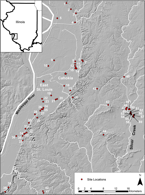
The American Bottom, a wide floodplain of the Mississippi River near modern East St. Louis, Illinois, was the locus of the precolumbian city of Cahokia. The political-ceremonial core of this regional polity consisted of a sprawling linear conglomeration of about 200 mounds and habitation areas that encompass the Cahokia, East St. Louis, and St. Louis precincts, surrounded by numerous related hamlets and villages in the nearby floodplain and uplands (Figure 1; Emerson Reference Emerson2002; Fowler Reference Fowler1997; Pauketat Reference Pauketat1994). The site of Cahokia proper is the largest of these precincts with an estimated peak population of 8,000 to 15,000 people (Pauketat Reference Pauketat2003; Pauketat and Lopinot Reference Pauketat, Lopinot, Pauketat and Emerson1997).
Sites mentioned in text: 1) Vaughn Branch, 2) Old Edwardsville Road, 3) Russell, 4) Lawrence Primas, 5) Auburn Sky, 6) Loyd, 7) Karol Rekas, 8) Esterlein, 9) Horseshoe Lake, 10) Auburn Sky, 11) Sponemann, 12) Radic, 13) Robert Schneider, 14) BBB Motor, 15) Robinson's Lake, 16) Olszewski, 17) Tucker Drive, 18) Holdener, 19) Lohmann, 20) DeMange, 21) Turner, 22) Fingers, 23) Curtiss Steinberg, 24) Florence Street, 25) Julien, 26) Sandy Ridge Farm, 27) Marcus, 28) Labras Lake, 29) McLean, 30) Range, 31) Mund, 32) George Reeves, 33) Dohack, 34) Leingang, 35) Carbon Dioxide, 36) Fish Lake, 37) Marge, 38) Hawkins Hollow, 39) Woodland Ridge, 40) Sprague, 41) Dugan Airfield, 42) Christy Schwaegel, 43) Grossmann, 44) Miller Farm, 45) Copper, 46) Knoebel, 47) G. Pinch, 48) Appel, 49) Adam and Eve Schoebert, 50) Technique, 51) E.J. Pfeifer #1, 52) James Faust, 53) John Faust #2, 54) John Faust #1, 55) J. Sprague, 56) Vesta Lembke, 57) Wm. Lembke Jr. #2, 58) Lembke #2, and 59) Lembke #3.

The initial consolidation of the central political administrative complex (“downtown” Cahokia, East St. Louis, and St. Louis precincts [Pauketat Reference Pauketat2004]) began around AD 1050 with the initiation of monumental constructions at and around Cahokia (Dalan et al. Reference Dalan, Holley, Woods, Watters and Koepke2003; Schilling Reference Schilling2014), waves of immigration from elsewhere in the Midwest (Alt Reference Alt, Butler and Welch2006a), and the reconfiguration of rural and urban spaces (Emerson Reference Emerson1997). The layout of the urban landscape was reconfigured and entangled with meaning, oriented to a site-wide grid that referenced the movement of cosmological bodies (Baires Reference Baires2017; Pauketat Reference Pauketat2013a; Romain Reference Romain, Pauketat and Alt2015). Wooden posts that initially identified residential groups became associated with earthen monuments and specialized political-religious architecture with a concomitant increase in size to create “monumental” marker posts. Moreover, new and elaborate vessel forms (beakers, bottles, effigies) were incorporated into foodways. These transformations took place within an already occupied and meaning-laden landscape, entangling novel practices (e.g., platform mound building) with traditional practices of chunky playing (a meaning-laden game utilizing a stone disc and spear or arrow; see Pauketat Reference Pauketat2004) and burning for cleansing and termination.
The history of Cahokia is divided archaeologically into four phases corresponding to radiocarbon dates in combination with artifact and building seriations. Preceded by the Late Woodland and Terminal Late Woodland, the Mississippian period includes the Lohmann (AD 1050–1100), Stirling (AD 1100–1200), Moorehead (AD 1200–1275), and Sand Prairie (AD 1275–1350) phases (Fortier et al. Reference Fortier, Emerson and McElrath2006; Hall Reference Hall, Emerson and Lewis1991). These are often further divided into early and late subphases based on qualitative differences in ceramics, structure morphology, and site configurations.
The Dataset
To generate a regional history of the use of fire in building termination practices, we gathered abandonment information from published and unpublished site reports, academic journal articles, and book chapters on 2,721 structures from the late precontact American Bottom region (Table 1). Given the variability in availability and breadth of reported data, as well as variation regarding in-the-field identification of burned structures, this sample is likely not exhaustive. To identify temporal patterns, structures that could not be assigned to temporal affiliation were excluded. Additionally, only structures that the original excavators had identified as burned were utilized; the possibility remains that some structures were misclassified as burned due to redisposition of charcoal and burned elements in basin fill without evidence for in situ burning (see below for discussion of equivocal evidence for burning at Turner and DeMange). Individual structures were coded for evidence of burning (based on identification in the reports that noted burned structural elements and/or floors), floor artifact associations, size, shape, temporal affiliation, regional, and intrasite location.
Phase-Based Data on Burned Structures from the American Bottom.

*Evidence for burning is equivocal. Burned posts or logs are present, but no evidence for substantial or widespread burning across the floor of the structures.
**Building counts include only those structures confidently identified to a single phase.
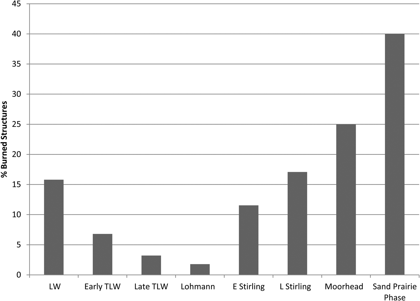
The frequency of burned structures was calculated on a regional level for seven periods spanning the Late Woodland (AD 350–900), Terminal Late Woodland (AD 900–1050), and Mississippian (AD 1050–1350) periods (Table 1). These frequencies were calculated based on the percentage of all excavated structures that were reported as having been burned in the American Bottom and adjacent eastern uplands. This era encompasses the development and decline of political complexity related to population centralization and urbanization in the region. Analysis of these data reveals well-demarcated diachronic changes in the frequency and context of burned structures in the American Bottom in conjunction with politico-religious changes in the region (Figure 2).
Percentage of burned structures by temporal phase in the American Bottom region. LW = Late Woodland, Early TLW = Early Terminal Late Woodland, Late TLW = Late Terminal Late Woodland, E Stirling = Early Stirling, L Stirling = Late Stirling. Only burned structures identifiable to a single phase are used.

Late Woodland
The Late Woodland period occupation of the American Bottom consisted of small-scale, seemingly egalitarian groups engaged in a swidden system of shifting cultivation (Koldehoff and Galloy Reference Koldehoff and Galloy2006). This period is further subdivided into early and late Late Woodland, consisting of the early Late Woodland Rosewood (ca. AD 350–500) and Mund (ca. AD 500–650) phases and the later Late Woodland Patrick (ca. AD 650–900) and Sponemann (ca. AD 800–900) phases (Fortier et al. Reference Fortier, Emerson and McElrath2006).
Patrick phase settlements varied from single households to small villages (Kelly Reference Kelly and Smith1990a). The latter were sometimes divided into small, kin-based groupings of lightly constructed single-post houses, storage pits, and earth ovens arranged around small courtyards (Figure 3; Kelly Reference Kelly and Smith1990b). Domestic architecture consisted of both rectangular and keyhole-shaped, bent-pole structures (Fortier Reference Fortier1985; Kelly et al. Reference Kelly, Fortier, Ozuk and Williams1987, Reference Kelly and Smith1990a; Koldehoff and Galloy Reference Koldehoff and Galloy2006). Large, rectilinear buildings, presumed to be council houses, are found at certain Late Woodland sites (Range and Fish Lake). The Sponemann phase temporally overlaps with the Patrick phase but marks the appearance of potentially nonlocal people to the region who were identified based on differing pottery production practices in conjunction with a greater “frequency and ubiquity” in the use of maize than other Late Woodland sites (Simon and Parker Reference Simon and Parker2006:230; see also Simon Reference Simon2017). Small amounts of Sponemann phase material are intermixed with Patrick phase material at sites located in the eastern uplands (Simon and Parker Reference Simon and Parker2006).
Distribution of burned structures at the Patrick phase occupation of the Range site. Adapted from Kelly Reference Kelly and Smith1990b:Figure 25.

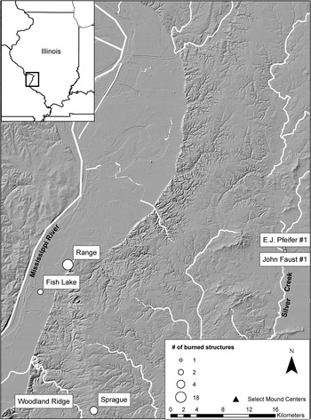
To evaluate Patrick phase and Sponemann phase structure burning practices, we gathered abandonment data on 171 structures from 14 sites in the region (see Table 1). Twenty-seven (15.79%) of these structures were reported as burned. Late Woodland sites with burned structures are roughly clustered in three locations: the southern American Bottom near the Pulcher locality; the southern uplands near Valmeyer, Illinois; and the eastern Richland Complex near the Silver Creek drainage (Figure 4). The highest number of burned structures occurs at the Range site (n = 18, two-thirds of the burned Late Woodland structures). Building burning appears to have been a practice more common at sites with Patrick phase occupations; only two burned buildings, both located at intermixed sites in the eastern Richland Complex, were identified as Sponemann phase. This suggests that the practice of termination via fire was autochthonous to the American Bottom rather than introduced by Sponemann phase peoples.
Spatial distribution of burned structures in the Late Woodland period.

A close examination of burned Late Woodland buildings reveals there is little besides burning that marks them as unusual. There is little pattern to the spatial distribution of burned buildings at the sites where they were found. All Late Woodland burned buildings appear to be typical domestic structures of a size, shape, and construction method comparable to the unburned structures in the study sample. Further, they lacked whole pots and other complete artifacts, indicating they were cleaned out prior to burning.
Two buildings at the Range site and two at the nearby Fish Lake site are the only structures with any indication of material added to or left in the structures prior to termination. These buildings (all keyhole structures, incidentally) contained large amounts of burned nutshell (Fortier et al. Reference Bennett1984; Kelly et al. Reference Kelly, Fortier, Ozuk and Williams1987; Supplemental Table 1). Additionally, the two keyholes at Range also yielded small numbers of tobacco seeds and nightshade seeds (Fortier Reference Fortier1985). Despite their mundane nature, the inclusion of nutshell in these buildings may be considered as an offering, though one that is relatively unelaborated compared to subsequent Mississippian period incinerations that often targeted special-purpose structures and related politico-religious paraphernalia (see Baltus and Baires Reference Baltus and Baires2012).
There is little evidence to suggest these burning rituals were controlled by specialists or were otherwise restricted in terms of performance. To the contrary, the presence of burned structures at small sites and their wide distribution at villages indicates incineration was a common means of ritually abandoning domestic structures.
Terminal Late Woodland
The Terminal Late Woodland (TLW) was an era (ca. AD 900–1050) when maize cultivation became significantly more ubiquitous (Simon Reference Simon2017) and the first large villages in the region appeared at different times and locations throughout the period (Fortier and McElrath Reference Fortier and McElrath2002; Kelly Reference Kelly and Smith1990a:144–145). Early mound construction has been identified at the Morrison site north of Cahokia, at the southern American Bottom Washausen site, and potentially at the Pulcher site (Barrier Reference Barrier2014; Betzenhauser Reference Betzenhauser2011; Betzenhauser et al. Reference Betzenhauser, Pauketat, Malouchos, Lopinot and Marovitch2017; Kelly Reference Kelly1993). Diversity is apparent in pottery production, with the emergence of differing traditions between the northern and southern American Bottom (Fortier et al. Reference Fortier, Emerson and McElrath2006). Ritually important items such as community structures, pipes, and chunky stones are widely distributed at TLW sites rather than restricted to a particular subgroup (Fortier and McElrath Reference Fortier and McElrath2002).
Our assessment of TLW period burning entails the analysis of data from 967 structures at 17 sites, temporally divided into early (AD 900–1000) and late (AD 1000–1050) subperiods (see Table 1). Examination of these data reveals a notable drop in the frequency of burned structures from more than 15% in the Patrick and Sponemann phases of the Late Woodland to 6.80% in the early TLW period and 3.21% in the late TLW period.
Sites with burned buildings continue to be concentrated in the Pulcher locality, with an enduring presence in small numbers in the eastern Richland Complex during the early TLW (Figure 5). A notable shift in spatial location of burned buildings occurred during the late TLW, with burned buildings occurring only around the Pulcher locality at the Marge, George Reeves, and Range sites. The Range site continued to be intensively occupied with the greatest number of burned buildings (n = 33) among the TLW sites. Additional evidence, including nonlocal pottery and unusual artifacts, suggests that Range (as part of the Pulcher locality) may have been a gathering place uniting people regionally and extra-regionally (Hanenberger et al. Reference Hanenberger, Milner, Pullins, Paine, Kelly and Parker2003; Kelly Reference Kelly and Smith1990b; Kelly et al. Reference Kelly, Ozuk and Williams2007).
Spatial distribution of burned structures in the Terminal Late Woodland period.

Burned TLW structures contain more artifacts—including pottery, chert, sandstone, and limestone—than those of the Late Woodland. Complete objects, such as a drill and celt from the northwest and southeast corners of one building from the George Reeves site, suggest intentional deposition, while the incorporation of a discoidal and pipe into the burned fill of two buildings at the Range site indicate that practices of burning began to include material objects. The inclusion of objects in burned buildings seems to be more prevalent during the latter part of the TLW.
The TLW population concentration at the Range site, in conjunction with early mound construction at the nearby Pulcher site, raises the possibility this coalescence included other acts of ceremonialism or purification that were increasingly concentrated in certain places and relegated to certain people. Early mound construction likely entailed coordinating efforts of religious specialists or community leaders, providing the possibility that those leaders or specialists organized other community practices such as building termination via fire. If such ritual performances allowed individuals to distinguish themselves on a local kinship or community level, their resulting authority does not appear to have crossed significantly into other political-economic domains at that time. Further, it does not appear to have entailed the elaboration of the ritual process itself as burned structures were still widely distributed within sites and typically lacked intentional deposits of whole pots, tools, or religiously charged materials.
Early Mississippian
Lohmann Phase (AD 1050–1100)
The Lohmann phase initiation of the Mississippian period in the American Bottom was marked by the sociopolitical coalescence at Cahokia. There was a dramatic population increase at Cahokia structured by the nucleation of existing regional populations and an influx of immigrants from surrounding regions (Alt Reference Alt, Butler and Welch2006a; Pauketat and Lopinot Reference Pauketat, Lopinot, Pauketat and Emerson1997; Slater et al. Reference Slater, Hedman and Emerson2014). Single-post constructed buildings were replaced by wall trench structures as part of the process of Cahokian community identity formation (Pauketat Reference Pauketat2004). Construction of Monks Mound, the Grand Plaza, and other structures began (Dalan et al. Reference Dalan, Holley, Woods, Watters and Koepke2003; Schilling Reference Schilling2014), and Cahokia was reorganized according to an internal grid (Fowler Reference Fowler1997). The rapid initiation of large-scale construction efforts indicates centralized planning, organizing, and cosmological place-making (see Baires Reference Baires2017). Contemporaneously, the adjacent floodplain was reorganized to consist of dispersed farmsteads united by political and religious nodal sites (Emerson Reference Emerson1997). The wide-scale spatial and social reorganization that took place during the Lohmann phase suggests that what may have begun as a communal religious movement associated with ancestor deities, mound construction, and cosmological interventions (Emerson Reference Emerson1997; Pauketat Reference Pauketat2004, Reference Pauketat2013a) simultaneously coalesced leadership roles into powerful elite identities.
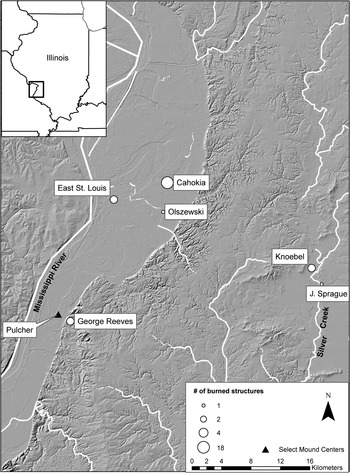
During the Lohmann phase, we see a continued decline in burned structures in the American Bottom (see Figure 2). Among 613 excavated buildings dating to this period, only 11 (1.79%) demonstrate evidence for burning (see Table 1).Footnote 1 We see the first burned structures at Cahokia; burned buildings are also present in low numbers in the eastern uplands and in the Pulcher locality (Figure 6).
Spatial distribution of burned structures in the Lohmann phase.

The decreased frequency of burned structures during the Lohmann phase suggests changing relationships associated with this practice, a supposition supported by novel contexts of burned structures. At Cahokia, burned buildings were incorporated into and restricted to mound construction seemingly as acts of termination and renewal that built upon a traditional use of fire to clear abandoned buildings from the landscape. Excavations into Monks Mound and Murdock Mound, located in the politico-religious heart of the site, have revealed a series of special-use structures below and on mound surfaces that were burned and subsequently renewed with layers of earth (Benchley Reference Benchley and Fowler1975). For example, a cruciform structure that was burned and immediately covered with soil initiated the Lohmann phase construction of the Murdock Mound located along the eastern edge of the Grand Plaza (Smith Reference Smith1969).
Only six Lohmann phase burned buildings have been identified outside of Cahokia; most appear to have been typical domestic structures that were cleaned out prior to burning (see Table 1). Two of these buildings are located at the George Reeves site in the southern American Bottom and were built directly over previous TLW buildings, indicating they were constructed early in the Lohmann phase (McElrath and Finney Reference McElrath and Finney1987). Additionally, these are also the only two Lohmann phase burned buildings that included artifacts—charred nuts, chert, pottery, limestone, and sandstone (see Supplemental Table 1). These materials were similar to those found in TLW structures at the same site, suggesting persistence of practice. Three additional Lohmann phase burned buildings have been excavated in the eastern uplands (Holley, Parker, Watters, Harper et al. Reference Holley, Parker, Watters, Harper, Skele and Ringberg2001; Holley, Parker, Scott, Watters, Skele, and Williams Reference Holley, Parker, Scott, Watters, Skele and Williams2001). It is important to note that most of these burnings took place on the fringes of early Cahokia, exhibiting a temporal lag in the adoption of certain Cahokian architectural and ceramic traditions during the Lohmann phase (Alt Reference Alt and Pauketat2001; Kelly Reference Kelly2002; Wilson Reference Wilson1998).
The use of fire to terminate domestic structures appears to have been a persistent tradition that was still performed, albeit infrequently, on the boundaries of early Cahokia. At Cahokia itself, however, the use of fire in building termination had shifted to nondomestic contexts associated with mound construction. The shift in context indicates a bundling of mound construction and the element of fire as part of the larger assembling process of Cahokian religion. Presumably, the relations formed through this process included those between powerful materials and elements and people with the ability to access their power and bring them together.
Stirling Phase (AD 1100–1200)
The subsequent Stirling phase marked the beginning of what is considered the “Classic” Cahokia period. During this era, we see connections between Cahokia and sites scattered throughout the northern and southern hinterlands indicated by imported raw materials, finished products, and practices of mound and building construction (Emerson and Lewis Reference Emerson and Barry Lewis1991; Welch Reference Welch2006). Formalized political-religious buildings introduced during the Lohmann phase continued to be built and used during the Stirling phase. Strict adherence to the Cahokian grid diminished as buildings were reoriented to local mounds and plazas (Collins Reference Collins1990) and some formerly residential areas of Cahokia were converted to public space (Pauketat Reference Pauketat1998).
The Stirling phase can be subdivided into Early Stirling and Late Stirling. The Late Stirling phase signals early warnings of a shift in the political winds in the Cahokian world. Interregional connections began to wane. In the northern hinterlands, sites in regions previously connected to Cahokia (e.g., Aztalan, Central Illinois River Valley) were fortified, and region-wide warfare started to become prevalent (Conrad Reference Conrad, Emerson and Lewis1991; Goldstein and Richards Reference Goldstein, Richards, Emerson and Lewis1991; Krus Reference Krus2016; Wilson Reference Wilson and Pauketat2012). Near the end of this period, palisades were constructed around the center of the Cahokia precinct (Iseminger et al. Reference Iseminger, Pauketat, Koldehoff, Kelly, Blake, George, Lopinot, Dalan and Woods1990), and a compound was built around a large group of storage structures in the East St. Louis precinct (Fortier Reference Fortier2007; Pauketat Reference Pauketat2004, Reference Pauketat2005). This compound and a number of storage structures were burned, which Pauketat and colleagues (Reference Pauketat, Fortier, Alt and Emerson2013) suggest was part of a political act that culminated with the depopulation of that precinct and much of downtown Cahokia, a shift in political structure, and the decentralization of Cahokian politics.
Significantly more Stirling phase structures have been excavated than earlier phases—880 of which are considered here—and more buildings were burned. Throughout the entire span of the Stirling phase, 8.07% buildings were burned, more than four times the occurrence than in the preceding Lohmann phase. The overall number of burned buildings at each site continued to be fairly low during the Early Stirling phase, with only one to two burned structures per site (Figure 7). Many of the burned structures were specialized buildings associated with Cahokian religious-administrative outposts or nodal sites, discussed in more detail below. Much like the mound-top structures during the Lohmann phase, these specialized structures were cleaned out and burned.
Spatial distribution of burned structures in the Early Stirling phase.

The relationship between powerful places and burning continued in mound contexts. For example, at Cahokia's Murdock Mound, a set of paired buildings, one rectangular and one circular and each with atypical clay-lined floors and clay hearths, was burned and covered over with a layer of mound fill (Smith Reference Smith1969). As part of a new trend, a large Ramey Incised pot was left on the floor of the rectangular building (see Supplemental Table 1).
A similar sequence of events is presumed at the Kunnemann Mound located north of Monks Mound. At least one of the two Kunnemann Mound structures that were completely excavated and identified as dating to the early Stirling phase demonstrated evidence of burning (Pauketat Reference Pauketat1993). This L-shaped building had a formal hearth and woven mat wall coverings and contained an array of offertory inclusions consisting of complete ceramic vessels, shell hoes, bone, chert, grinding stones, corn, and tools for shell-bead production (Baltus and Baires Reference Baltus and Baires2012; Pauketat Reference Pauketat1993; see Supplemental Table 1). Seemingly, terminating these mound-top buildings with fire was one step in the periodic renewal of the mound surface.
During the Early Stirling phase, burned nonmound buildings included those that were clearly extra-domestic, identified as such through unusual shape (L, T, or circular), size, or associated materials. Included among these was a large rectangular building at the Range site (the largest Stirling phase structure there), which was centrally located near a series of special-purpose circular structures (Hanenberger et al. Reference Hanenberger, Milner, Pullins, Paine, Kelly and Parker2003). Rather than the nutshell that was incorporated in earlier burned buildings at Range, maize was found on the floor of this Early Stirling building.
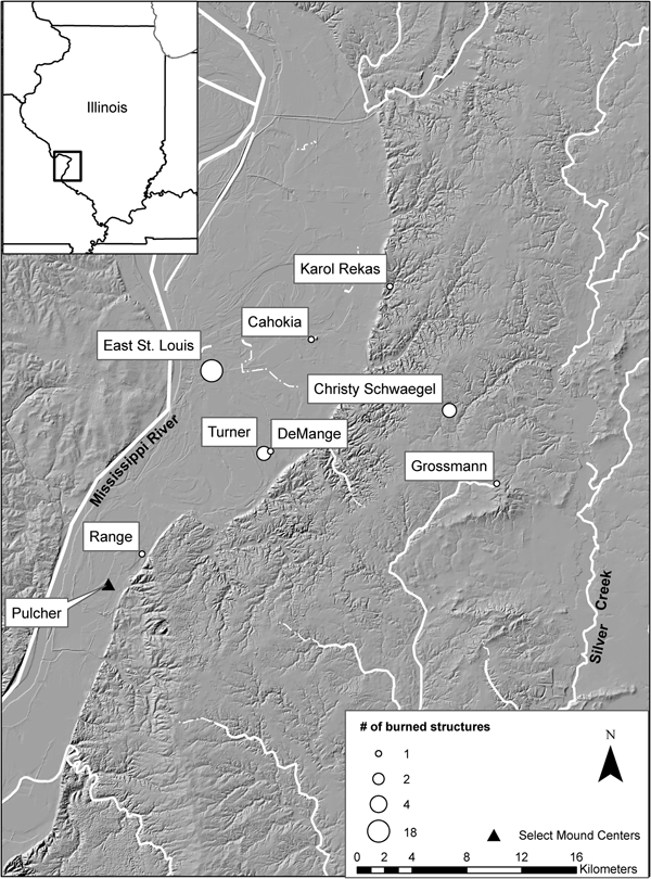
Additional special-use structures—a unique T-shaped building and an associated rectangular structure—were cleaned out and burned at the Christy Schwaegel site in the uplands southeast of Cahokia (see Figure 7). These paired buildings have been interpreted as a temple (or medicine lodge) and priestly residential complex (Pauketat et al. Reference Pauketat, Kruchten, Baltus, Parker and Kassly2012). A similar T-shaped structure with an internal bench was also burned at the Grossmann site, an upland Cahokian administrative center located southeast of Christy Schwaegel (Alt Reference Alt2006b).
A few Early Stirling phase structures offer somewhat inconclusive information regarding their termination. A nondescript building at the Karol Rekas site was burned, and a triangular projectile point and Powell Plain-like jar were recovered from it (Jackson and Hanenberger Reference Jackson and Hanenberger1990; see Figure 7). This was the only building excavated at the site, though it does not appear to have been remarkable in any way aside from burning. The addition of a small number of objects prior to burning is reminiscent of offerings made in some buildings during the latter part of the TLW and Lohmann phase. Additionally, two rectangular structures at the Turner site and a rectangular structure at the nearby DeMange site were reported as abandoned and partially filled prior to burning (Milner Reference Milner1983). Evidence for structural burning is ambiguous given the lack of structural elements (i.e., no burned posts, timbers, or thatch in situ), suggesting these structures may have been commemorated through later revisiting and burning events (see Alt and Pauketat Reference Alt, Pauketat, Barber and Joyce2018 for examples of commemorative burning at Cahokian shrine sites).
Burned structures were bundled with earthen platform mounds during the Lohmann phase. During the Early Stirling phase, this assemblage included clearly politico-religious buildings (L- and T-shaped structures and associated buildings), indicating transformations in the meaning and practice of burning structures. No longer was burning used to terminate typical domestic dwellings; rather, it seems to have become primarily restricted to special-use structures (temples, charnel houses) or those associated with special people. The only burned buildings outside of Cahokia—except for the inconclusive evidence from Turner and DeMange—are nondomestic or extradomestic structures at sites that could be considered administrative or nodal (Emerson Reference Emerson1997). The centralization and restriction of termination via fire seems to have become part of the larger bundle (after Pauketat Reference Pauketat2013a; see also Zedeño Reference Zedeño2008) of relations, elements, and materials assembled into Cahokian political-religious practices, which simultaneously empowered a restricted group of people who maintained or controlled those powerful elements, practices, and materials.
Structural burning changed qualitatively during the Late Stirling phase, and was potentially connected to the broader political and religious changes occurring in the region (Figure 8). While the burning of the storage compound at East St. Louis inflates the number of burned structures, the large number of Late Stirling phase buildings excavated at that site contributed to an overall frequency of burning that was nearly identical to the Early Stirling phase.
Spatial distribution of burned structures in the Late Stirling phase.

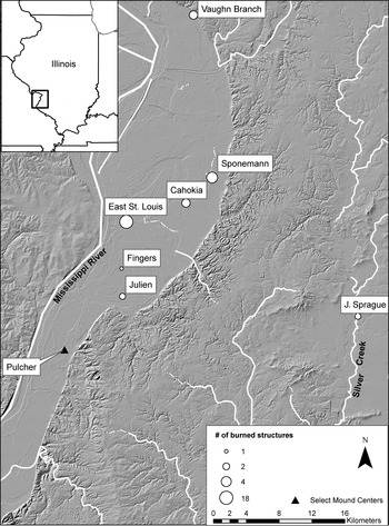
A greater number of burned buildings outside of Cahokia and East St. Louis may also be linked in some way to these decentralizing trends. Burned buildings are found in the northern American Bottom floodplain in addition to around Cahokia and in the eastern uplands. Fewer of the burned buildings were obviously politico-religious structures with the exception of a circular structure at the Vaughn Branch site described below. A few individual structures demonstrate continuity with the earlier Stirling phase tradition of cleaning prior to termination (Holley, Parker, Watters, Harper et al. Reference Holley, Parker, Watters, Harper, Skele and Ringberg2001; Kelly Reference Kelly1995; Milner Reference Milner1984). The majority of burned buildings dating to the Late Stirling phase, however, contained domestic and extra-domestic objects on their floors or cached in interior pits (see Supplemental Table 1).
Among those buildings that demonstrate overall continuity with the practice of thorough cleaning prior to termination are two Late Stirling phase structures at the J. Sprague site in the uplands southeast of Cahokia. While these buildings are on the higher end of building size for the Late Stirling, they are by no means oversized in a way that suggests special use. These buildings were arranged together in a string of three similarly oriented and seemingly contemporaneous buildings (Holley, Parker, Watters, Harper et al. Reference Holley, Parker, Watters, Harper, Skele and Ringberg2001). The center building was constructed over the previous location of the largest structure on the site and had an unusual interior storage facility, suggesting use beyond domestic functions. This building was mostly cleaned out, with the exception of a Cahokia Tri-notched point and stone hoe cached in an interior pit and subsequently burned (Holley, Parker, Watters, Harper et al. Reference Holley, Parker, Watters, Harper, Skele and Ringberg2001). Concentrations of nuts were also found along the interior edges of the wall trenches, referencing earlier practices in which foodstuffs were offerings. The second burned structure, located on the eastern edge of the string of buildings, was cleaned out completely prior to burning (Holley, Parker, Watters, Harper et al. Reference Holley, Parker, Watters, Harper, Skele and Ringberg2001).
Much like the artifacts burned on the floor of the Early Stirling Kunnemann Mound structure, the materials incorporated within the majority of burned Late Stirling structures range from seemingly domestic debris to artifacts that have powerful relational or affective qualities (e.g., flintclay figurines, specialized bifaces, quartz crystals, pigments). For example, three of the six structures at the nodal Vaughn Branch site in the northern American Bottom were burned (Jackson and Millhouse Reference Jackson and Millhouse2003). Two of these were rectangular buildings with central hearths, whereas the third was a circular sweatlodge (Jackson and Millhouse Reference Jackson and Millhouse2003). The sweatlodge was completely cleaned out prior to burning; the two rectangular buildings, on the other hand, contained a number of artifacts (vessel fragments, chert tools, debitage, cores, an anvil, galena, and corn). Nightshade seeds were found in association with both buildings, suggesting extra-domestic activities.
Six structures were burned at the ceremonial site of Sponemann, located at the margins of Cahokia (Fortier et al. Reference Fortier, Maher and Williams1991). Two buildings located in the “residential complex” contained a small amount of material: a wooden mortar or bowl left in one rectangular building and vessel fragments, a hammerstone, projectile point, and abraders recovered from the second, a small, square, possible storage structure. The other four buildings were rectangular structures located within the “ceremonial complex,” which had numerous nondomestic and domestic-like artifacts on the floors, including caches of stone tools, numerous vessels and vessel fragments, and plants used in medicinal or ritual practices (Jackson et al. Reference Jackson, Fortier and Williams1992). One structure had at least three female flint-clay figurines that had been fragmented and placed on the floor prior to burning (Jackson et al. Reference Jackson, Fortier and Williams1992). It appears that these were considered powerful objects intentionally included within the structures to be burned.
In downtown Cahokia, there are two well-known examples of burned Late Stirling phase structures that included similar assemblages of domestic and extra-domestic artifacts. House 4, located east of Monks Mound and superimposed by the second construction episode of the palisade wall, had an interior platform, suggesting this may not have been a normal domestic structure (Pauketat Reference Pauketat1987). This structure contained turtle carapace bowls or rattles, hammerstones, conch shells, shell hoes, celts, bone pins, galena cubes, and abraders, along with a full complement of ceramic vessels. The second building, Structure 178, southeast of the Grand Plaza, was oriented to Mound 107 and also had interior benches and an interior partition. Along with whole pots, chert woodworking tools and production tools were deposited on the floor (Collins Reference Collins1990). Collins (Reference Collins1990:150) suggests that because the assemblages of House 4 and Structure 178 were nearly identical and were located proximal to mounds, they may have been utilized by important community leaders. Given their locations and internal features, it is likely that extra-domestic practices utilizing powerful paraphernalia occurred within these buildings, making them notable locations on the Cahokian landscape.
The largest number of burned structures dating to the Late Stirling phase has been excavated at East St. Louis, as noted earlier. Approximately 24 small, square-to-rectangular buildings, with an estimated additional 70 similar buildings, were enclosed within a palisade. These small buildings, interpreted as storage structures, contained stores of shelled maize, iconographic Ramey Incised jars, pigments, crystals, specialized bifaces, and other seemingly nondomestic objects (Fortier Reference Fortier2007). All these structures appear to have burned in a conflagration event during the Late Stirling phase (Fortier Reference Fortier2007; Pauketat et al. Reference Pauketat, Fortier, Alt and Emerson2013). Possibly as part of this event, at least one additional Late Stirling structure was burned at the northern end of the East St. Louis precinct (Brennan Reference Brennan2018a).
There were clearly important changes in the ritual use of fire over the course of the eleventh and twelfth centuries in the American Bottom. During the Lohmann and Early Stirling phases, fire appears to have been used as a cleansing element, physically and potentially spiritually transforming powerful spaces, sometimes with an addition of soil for purification resulting in mounded stratigraphy. The seemingly intentional inclusion of domestic and extra-domestic artifacts suggests that many Late Stirling phase structures were burned with transformed significance. It becomes clear that in the Late Stirling phase, burning structures was a practice retained for specific building types with certain materials bundled into the burning assemblage. Many of the burned buildings appear to have been used for extra-domestic purposes or paired with extra-domestic buildings as signified by location, interior platforms or benches, and medicinal plants.
The bundling of certain buildings with particular materials cached or left on floors of these buildings is documented in numerous unburned structures across the American Bottom (Baltus Reference Baltus, Koldehoff and Pauketat2018); however, additional meaning is created when assembled together with or through fire. While some buildings prior to the Late Stirling phase contained some objects, like burned corn or nutshell and single tools or vessels, the Late Stirling burning events increased the scale and complexity of this practice. Baltus and Baires (Reference Baltus and Baires2012) suggest that these structures may have been burned as a means of transfiguring particular formalized Cahokia politico-religious practices through the transubstantiation of the material aspects of these practices. Indeed, these Late Stirling conflagration events must be understood in the context of the political and demographic changes that defined the end of the Stirling phase and the beginning of the Moorehead phase.
Late Mississippian
Moorehead Phase (AD 1200–1275)
The Moorehead phase signifies in some ways a historical break with the practices and politics of the Stirling phase as demonstrated by changes in pottery, politico-religious buildings, mound building practices, and population distribution in the American Bottom. A number of these structural and material changes are citational of pre-Cahokian traditions or demonstrate a persistence of practice through the Cahokian sequence (Baltus Reference Baltus2014). For example, the specialized (i.e., circular, T-, and L-shaped) buildings associated with Lohmann and Stirling phase Cahokian religious politics were no longer constructed; simultaneously, the more inclusive council house buildings, similar in size and shape to the large communal structures built during the Late Woodland, were maintained throughout the Mississippian period. Pottery was once again cordmarked rather than smoothed, again reminiscent of the Late Woodland, and tree nuts saw resurgence in subsistence significance (Simon and Parker Reference Simon and Parker2006).
The population levels at Cahokia proper decreased during the Moorehead phase, and the occupation of the site appears to have constricted to the central precinct area (Dalan et al. Reference Dalan, Holley, Woods, Watters and Koepke2003; Pauketat Reference Pauketat2004; though see Baires et al. Reference Baires, Baltus and Malouchos2017). At the same time, a number of sites were founded or continued to be occupied in the floodplain and uplands. Mound building consisted largely of additions of large clay caps as opposed to the incremental layers previously added (Dalan et al. Reference Dalan, Holley, Woods, Watters and Koepke2003; Pauketat Reference Pauketat1993; Trubitt Reference Trubitt2000). During this period, however, we see evidence for new or continued interregional connections, including nonlocal pottery and mortuary practices (e.g., stone-box graves, incorporation of vessels, and use of fire in burials) that suggest relationships with groups in northern and central Illinois as well as in the mid-South (Baltus Reference Baltus2014; Emerson and Hargrave Reference Emerson and Hargrave2000).
The frequency of burned Moorehead phase structures in the American Bottom (25%) is slightly higher than the preceding Late Stirling phase (17.07%; see Figure 2). Burned buildings are again found in small numbers (typically one or two) at sites in the Moorehead phase but are present at a greater number of sites (Figure 9). These sites follow a pattern that cites pre-Mississippian burning practices concentrated at locations in the southern American Bottom and the eastern uplands; however, we also see a greater concentration of burned buildings in the northern American Bottom.
Spatial distribution of burned structures in the Moorehead phase.

The burning of certain mound-summit temples continued into the Moorehead phase at the Murdock Mound and on Mound 11 at East St. Louis. The building on Murdock Mound was completely cleaned out prior to burning (Smith Reference Smith1969), while materials were on the floor of the structure on Mound 11, including a Mill Creek biface, a pipe, two bottles, and a jar (Pauketat Reference Pauketat2005). The burning of these structures marked the final use of both of these mounds (Pauketat Reference Pauketat2005; Smith Reference Smith1969).
We see a return to other TLW/early Mississippian practices associated with the burning of buildings, namely the removal of objects from the structures prior to termination. Two-thirds of the Moorehead phase burned buildings were cleaned out before burning or contained only a small number of inclusions: a bowl fragment in a wall trench at Faust #1, two sherds from a circular sweatlodge at Old Edwardsville Road, and charred nuts in a building at Loyd (see Supplementary Table 1).
Only four buildings contained artifacts placed, prior to termination, on the floors, in interior pits, or in the wall trenches of the structures. One burned building west of Monks Mound at Cahokia (Tract 15A) had an internal platform or partition and whole tools cached on the floor (Pauketat Reference Pauketat1998). Similarly, two structures at the Julien site had been cleaned prior to burning, with the exception of 12 projectile points in one structure and one point in the other (Milner Reference Milner1984). The addition of artifacts in these structures differs in quantity and type from that of the mound summit building at East St. Louis. These buildings contain only stone tools, which were gathered and placed inside the structures prior to burning rather than what appears to have been the entire politico-religious assemblage of the Mound 11 building.
Only one burned structure does not fit the Moorehead phase trend and is similar to the Mound 11 structure. A rectangular building at the Lawrence Primas site, associated with what appears to have been the latest known sweatlodge in the American Bottom region, had a central post that was burned in place with a mini-vessel offering placed under the post. Mill Creek hoes, projectile points, a biface, a chert pick, cores, manos, an anvil, abraders, a spindle whorl, a bone awl, corn and nutshell, complete and fragmented specialized bifaces, an elbow pipe, and galena cubes were located on the floor (Pauketat and Woods Reference Pauketat and Woods1986). This inclusion of domestic and extra-domestic artifacts prior to conflagration is reminiscent of the Late Stirling phase and suggests the building's significance may have been on par with that of the Mound 11 summit structure.
The fewer number of burned buildings—many of large size, unusual shape, or containing interior partitions and benches—suggest that this practice centered on public-use or specialized structures during the Moorehead phase. We see three means (and multiple meanings) of termination via fire during the Moorehead phase: 1) complete cleaning (though sometimes with a small number of fragmented artifacts or nutshell), reminiscent of the pre-Cahokian and early Cahokian TLW/Lohmann phase; 2) the addition of intentionally placed stone tools, ordered (often with tools nested together) and carefully interred within a cleaned structure, reminiscent of the early Stirling phase; and 3) conflagration with a full complement (and perhaps more) of objects left in place, similar to many buildings burned during the late Stirling phase. Perhaps this complex Moorehead phase pattern is the product of the termination of public meeting spaces and other special-use religious structures along with the revival of fire to terminate domestic structures, some of which entailed the inclusion of commemorative artifact caches. The importance of burning certain buildings and their objects seems to have persisted into the Moorehead phase though the practice of burning buildings may no longer have been restricted to particular individuals or groups.
Sand Prairie Phase (AD 1275–1350)
The Sand Prairie phase is less well-known than the preceding Mississippian phases. Few sites dating to this period have been systematically excavated and reported (Baltus Reference Baltus2014; Holley, Parker, Watters, Harper et al. Reference Holley, Parker, Watters, Harper, Skele and Ringberg2001; Holley, Parker, Watters, Harper, Skele, and Ringberg Reference Holley, Parker, Watters, Harper, Skele, Ringberg, Brown and Booth2001; Holley, Parker, Scott, Watters, Skele, and Williams Reference Holley, Parker, Watters, Harper, Skele, Ringberg, Brown and Booth2001; Jackson Reference Jackson2015; Jackson et al. Reference Jackson, Fortier and Williams1992; Milner Reference Milner1984; Pauketat Reference Pauketat2013b), perhaps reflecting a decreased population during this period. The floodplain population fell, whereas the uplands population may have resurged; occupation and Mississippian ceremonialism continued in various forms in the Silver Creek uplands east of the American Bottom (Baltus Reference Baltus2014; Holley, Parker, Watters, Harper et al. Reference Holley, Parker, Watters, Harper, Skele and Ringberg2001; Holley, Parker, Watters, Harper, Skele, and Ringberg Reference Holley, Parker, Watters, Harper, Skele, Ringberg, Brown and Booth2001; Holley, Parker, Scott, Watters, Skele, and Williams Reference Holley, Parker, Watters, Harper, Skele, Ringberg, Brown and Booth2001). The Sand Prairie occupation at Cahokia suggests a strong residential connection between people and place: structures are rebuilt in place, and burials are placed in or adjacent to residential buildings at abandonment (Pauketat Reference Pauketat2013b). Overall, this period is one of decentralization and eventual abandonment of Cahokia and the American Bottom.
The frequency of burned structures reached its highest point during this phase at 40% (see Figure 2). Of the nine sites for which we have structure data, five have burned structures, and two of those, Julien and Lembke #2, have multiple burned buildings. All these burned buildings are located outside Cahokia and are concentrated in the southern floodplain and eastern uplands (Figure 10).
Spatial distribution of burned structures in the Sand Prairie phase.

These burned structures demonstrate a similar, though perhaps intensified, pattern as that of the Moorehead phase. No burned Sand Prairie phase buildings were completely devoid of material (see Table 2). Half the buildings were cleaned out with the exception of a few artifacts left, or placed, on the floors. These buildings may represent domiciles that required transformation through fire as well as a small offering. For example, a building at the Florence Street site was cleaned out, and a chert core was placed on the floor along with corn and nuts (Emerson et al. Reference Emerson, Milner and Jackson1983). The sole Sand Prairie building at the Sponemann site contained two projectile points and a point base, an abrader, and three antlers in addition to a jar fragment and a corn cob (Jackson et al. Reference Jackson, Fortier and Williams1992). One of two Sand Prairie phase structures burned at the Lembke #2 site in the Silver Creek uplands was built directly over a previously burned Moorehead phase structure and contained only corn and nutshell on its floor. The second had a complete hoe and a projectile point placed on the floor prior to burning (Holley, Parker, Watters, Harper, Skele, and Ringberg Reference Holley, Parker, Watters, Harper, Skele, Ringberg, Brown and Booth2001).
One of the three burned Sand Prairie buildings at the Julien site had a similar pattern, containing only two projectile points in the otherwise cleaned out building. The other two, however, contained numerous artifacts. One had multiple Mill Creek hoes, four Ramey knives, one adze, and seven projectile points intentionally cached in two of its internal pits (Milner Reference Milner1984). Galena, hematite, and quartz—minerals used as pigment or paraphernalia in ritual contexts—were also recovered, suggesting this building had been used for extra-domestic purposes. The third structure contained a sandstone metate, turtle carapace, mussel shells, a celt, a grinding stone, a pottery trowel, an abrader, limestone, and ceramic vessels in situ (Milner Reference Milner1984). The incorporation of these materials bears similarities to buildings burned during the preceding Stirling and Moorehead phases.
Located in the far southern American Bottom, the only Sand Prairie building at the Hawkins Hollow site also contained numerous ceramic vessels, suggesting an assemblage that burned accidentally. However, the high number of stone tools—including four hoes, three adzes, four celts, and a spud—suggests intentional offerings as part of the fire termination (Jackson Reference Jackson2015). The center post of this building was red cedar, and a nightshade seed was also recovered, supporting the interpretation that the building was also used for extra-domestic purposes.
Structural burning during the Sand Prairie phase, though seemingly more prevalent than in previous phases, appears to follow a similar trend as the Moorehead phase. The majority of structures were cleaned prior to termination, many with stone tools placed on the floors or in interior pits. At least three structures were terminated with in situ debris, perhaps suggesting such offerings were isolated to special circumstances, buildings, or events. Termination via fire appears no longer to have been restricted to specialized structures or practitioners but once again was used to terminate domestic structures as well as religious/public buildings. It would appear that domestic termination rituals now included both cleaning out of structures and caching a small number of specific artifacts within the structures prior to burning. Perhaps including in situ assemblages and large caches, such as that at Hawkins Hollow, was reserved for specialized religious structures during both the Moorehead and Sand Prairie phases, continuing the practice of physically and spiritually cleansing a space while mitigating powerful objects after use.
Summary
The burning of buildings in the American Bottom began as a localized way of terminating and cleansing structures following their abandonment. Burned structures from the Late Woodland are found at a number of different sites, with nothing to suggest these buildings were unique. Potential offerings placed on the floors prior to burning typically consisted of important crops—nuts and maize—but little else. This ritual became increasingly restricted in performance over the course of the tenth and early eleventh centuries in conjunction with Cahokia's political consolidation around AD 1050. Specifically, the shift in context of burning (from seemingly ordinary buildings to mound-associated structures and specialized architecture) indicates a constriction in which buildings necessitated burning and, likely, the personnel performing those practices. We view this evidence as embedded within the political and relational processes that produced elite identities and powerful places and objects in the early Mississippian American Bottom.
Structure burning intensified during the Stirling phase, perhaps along with an increased clericalism associated with Cahokian religious politics. Other evidence for such clericalism includes the restricted use of certain paraphernalia (e.g., flint-clay figurine/pipes) which are found in the context of specialized structures (Emerson and Jackson Reference Emerson and Jackson1984; Jackson et al. Reference Jackson, Fortier and Williams1992), and certainly the circumscription of specific practices (e.g., violence in the form of human sacrifice; see Pauketat Reference Pauketat2004). The notable changes over time in the practice of structure burning suggest a continued process of meaning-making surrounding the use of fire for termination, from the addition of botanicals during the Late Woodland to the addition of artifacts in the TLW, association with mounds and increasingly nondomestic structures in the Lohmann through Stirling phases, and the intensified association with intentionally deposited offerings in Moorehead through Sand Prairie phases.
Those who initially drew the use of fire into the politico-religious assemblage of Cahokia, along with mound construction, may have done so as part of a broader entangled religious movement that entailed new meanings and repositioned practices. But over the long term, these small-scale politico-religious strategies may have had transformative impacts. Thus, what began as a widely practiced folk ritual became increasingly tied to particular places, practices, and people until it was restricted to specialists and community leaders, recursively constructing and reinforcing their increasingly elite identities. Early Mississippian assembling of Cahokian political and religious practices reinterpreted the ritual use of fire and restricted its performance to the spiritual cleansing and purification of mound-top temples, elite domiciles, and other important buildings. In turn, a burgeoning elite may have become imbued with the power associated with these locations and things and perhaps the element of fire itself (Baltus and Baires Reference Baltus and Baires2012).
During the twelfth century, the meaning of structural burning in the American Bottom transformed with specific specialized structures targeted for eradication or transfiguration with religiously charged paraphernalia left in situ. In addition to physical and spiritual cleansing offered by the burning of structures, fire was perhaps used in the late twelfth century as social or political cleansing as well, mitigating the power encapsulated within these buildings and objects, as well as the political identities associated with them.
In the years following these events, the burning of structures in the American Bottom was once again available as a domestic termination ritual—perhaps with an added element of spiritual as well as physical renewal, as offerings of stone tools are often found within the cleaned-out structures. Very particular buildings (exemplified by only five structures over 150 years) appear to be burned with a full complement of in situ objects, continuing the Late Stirling phase concern with mitigating the power contained within such special-use structures and their affiliated paraphernalia (Baltus and Baires Reference Baltus and Baires2012).
Conclusion
The practice of structural burning varied regarding political complexity and changing religious practices associated with the Native American city of Cahokia. Comparing the ritualized practice of structural burning diachronically and regionally demonstrates the elasticity of religious practices and mutability of meaning, as well as persistence of certain bundled practices through cultural transformation. The shifting practices of structural burning from a broadly utilized means of cleansing some buildings from the landscape to terminating specific politico-religious buildings highlight the indivisible nature of politics and religion regarding the complexities of urbanization. At identifiable points in time, increased religious expression and investment allowed power to become socially divisive, creating elite identities through centralization of powerful practices, here the use of fire in termination rituals. The bundling of fire with specific buildings beginning during the early years of coalescence at Cahokia intensified over time with the increased addition of specific objects and, in limited instances, entire assemblages in the fire. In the same scope, as the political-religious power of Cahokia waned, these practices once again were dispersed rather than centrally controlled, though with a new means (and meanings) of terminating buildings with extra-domestic associations. Fire, itself a transformational element, is likewise transformed through its associations with particular buildings, performances, persons, and materials over the course of history in the American Bottom.
Acknowledgments
We would like to thank Tom Emerson, Tim Pauketat, and the Illinois State Archaeological Survey for access to and permission to use unpublished data. We appreciate the thoughtful comments and suggestions of our anonymous reviewers, as well as comments on earlier drafts by Sarah Baires and Tim Pauketat.
Data Availability Statement
No original data were presented in this paper.
Supplemental Materials
For supplementary material accompanying this paper, visit https://doi.org/10.1017/aaq.2019.34
Supplemental Table 1. Burned structure details by phase and site.