

Luminescence dating can play an important role in better understanding preceramic settlements in South America, not only for chronological purposes but also for identifying mixed assemblages. The latter is particularly important for documenting early human colonization. We demonstrate this potential with the results of luminescence analysis on sediment samples from two sites in Uruguay, along the Rio Negro.
Uruguay is a small country, but it has an important archaeological record, both for the Paleoindian period spanning the Pleistocene/Holocene transition, and also for the poorly known early-to-mid Holocene. Comprehensive dating remains a problem because the radiocarbon record is spotty (López Mazz Reference López Mazz2013), partly due to lack of charcoal or bone in riverine settings, where most of the record is contained. Luminescence dating of sediments is a good alternative for stratified sites because the method dates depositional events directly. Eastern South America is particularly good for luminescence dating because of the presence of highly sensitive quartz with excellent luminescence properties (Sawakuchi et al. Reference Sawakuchi, Mendes, Pupim, Mineli, Ribeiro, Zular, Gudes, Giannini, Noguerira, Filho and Assine2016). It has seen widespread use in Brazil (Araujo et al. Reference Araujo, Feathers, Arroyo-Kalin and Tizuka2008, Reference Araujo, Strauss, Feathers, Paisani and Schrage2013, Reference Araujo, Paisania, Schrage, Feathers, Harmann and Ricci2017; Böeda et al. Reference Boëda, Clemente-Conte, Fontugne, Lahaye, Pino, Felice, Guidon, Hoeltz, Lourdeau, Pagli, Pessis, Viana, Costa and Douville2014; Bueno et al. Reference Bueno, Feathers and Blasis2013; Feathers et al. Reference Feathers, Piló, Arroyo-Kalin, Renato Kipnes and Coblenz2010; Lahaye et al. Reference Lahaye, Hernandez, Boëda, Felice, Guidon, Hoeltz, Lourdeau, Pagli, Pessis, Rasse and Viana2013).
Archaeological Importance of Uruguay
Uruguay has considerable potential to contribute to the academic debate on human colonization of the Americas. Although most scholars agree that the route was from Asia through North America, evidence from South America has confounded the issue of when this happened (Dillehay Reference Dillehay2000; Kelly Reference Kelly2003; Salemme and Miotti Reference Salemme and Miotti2008). Most noticeable has been the wide acceptance of the late Pleistocene dating of Monte Verde (Meltzer et al. Reference Meltzer, Grayson, Ardila, Barker, Dincauze, Haynes, Mena, Núñez and Stanford1997) in southern Chile, which undermined the traditional North American view of the primacy of the Clovis lithic tradition. Monte Verde is not alone; sites as early or possibly earlier than Clovis have been reported from throughout South America (e.g., Böeda et al. Reference Boëda, Clemente-Conte, Fontugne, Lahaye, Pino, Felice, Guidon, Hoeltz, Lourdeau, Pagli, Pessis, Viana, Costa and Douville2014; Bryan et al. Reference Bryan, Casamiquela, Cruxent, Gruhn and Ochsenius1978; Lahaye et al. Reference Lahaye, Hernandez, Boëda, Felice, Guidon, Hoeltz, Lourdeau, Pagli, Pessis, Rasse and Viana2013; Ochsenius and Gruhn Reference Ochsenius and Gruhn1979; Politis et al. Reference Politis, Prates and Ivan2008; Vialou et al. Reference Vialou, Benabdelhadi, Feathers, Fontugne and Vialou2017) although some of the older claims (>20 ka) have raised questions about the human origin of artifacts (Fiedel Reference Fiedel2017; Meltzer Reference Meltzer2009; Meltzer et al. Reference Meltzer, Grayson, Ardila, Barker, Dincauze, Haynes, Mena, Núñez and Stanford1997). Pre-Clovis sites have been claimed in the southern cone including Uruguay (Suárez Reference Suárez, Stanford and Stenger2014), but convincing evidence has been elusive (Steele and Politis Reference Steele and Politis2009). Other arguments, however, have been made for a pre-Clovis presence. Early South American sites reveal marked diversity in lithic technology and subsistence pursuits, which are difficult to reconcile with descent from Clovis (Dillehay 2008; Miotti Reference Miotti2003). Some genetic evidence also suggests an early migration to South America (de Saint Pierre Reference de Saint Pierre2017).
A convergence in South America of independently derived lithic traditions with distinctive unifacial and bifacial technologies, all potentially as old as Clovis, has been observed (Araujo Reference Araujo2015; Dillehay Reference Dillehay2000). One early manifestation is the fishtail point, also called the Fell point, after Fell's Cave excavated by Junius Bird in the 1930s in the Magellan Basin of southern Patagonia (Bird 1938). Fishtail points have been reported from south-central Mexico/Central America to southernmost South America (e.g., Bell Reference Bell1960; Bird and Cooke Reference Bird, Cooke and Bryan1978; Cassiano and Alvarez Palma Reference Cassiano and Alvarez Palma2007:Figure 10; Flegenheimer et al. Reference Flegenheimer, Miotti, Mazzia, Graf, Ketron and Waters2014; Loponte et al. Reference Loponte, Carbonera and Silvestre2015; Mayer-Oakes Reference Mayer-Oakes1986; Nami Reference Nami, Farias and Lourdeau2014a, Reference Nami2016, Reference Nami2017a; Ranere and Cooke Reference Ranere and Cook1995) but are most common in the southern cone. The densest concentrations have been found in Uruguay, in the Buenos Aires province of east-central Argentina (Flegenheimer et al. Reference Flegenheimer, Miotti, Mazzia, Graf, Ketron and Waters2014:Figure 21.1), and in southern Brazil (Loponte and Carbonera Reference Loponte and Carbonera2017; Loponte et al. Reference Loponte, Carbonera and Silvestre2015, Reference Loponte, Okumura and Carbonera2016).
Dated stratigraphic records indicate that fishtail points are roughly coeval with Clovis (Gruhn and Bryan Reference Gruhn and Bryan1977; Maggard and Dillehay Reference Maggard, Dillehay and Dillehay2011; Nami Reference Nami2007; Nami and Stanford Reference Nami and Stanford2016; Yataco Capcha and Nami Reference Yataco Capcha and Nami2016). Because of fluting, some have seen them as derivative of Clovis (Morrow and Morrow Reference Morrow and Morrow1999), but most South America researchers conclude that they are technologically distinct in both morphology and reduction sequence (Borrero Reference Borrero, Morrow and Gnecco2006; Nami Reference Nami1997; Politis Reference Politis, Bonnichsen and Turnmire1991). Despite these differences, both Clovis and Fell technology share some common features with Upper Paleolithic technology (Nami Reference Nami, Legrand-Pineau, Sidéra, Buc, David and Scheinsohn2010a, Reference Nami and Nami2010b, Reference Nami2013, Reference Nami, Farias and Lourdeau2014b). Fishtail points even have similarities with early points from southeastern United States (Faught Reference Faught, Morrow and Gnecco2006; Nami Reference Nami2016). Fishtail points also appear to have been used in contexts different than Clovis (Miotti Reference Miotti2003). They are associated with a wide variety of lithic assemblages produced by bifacial, unifacial, bipolar, and prepared-core techniques, and also appear in a wide variety of forms (Flegenheimer et al. Reference Flegenheimer, Miotti, Mazzia, Graf, Ketron and Waters2014; Nami Reference Nami1997, Reference Nami2007, Reference Nami, Farias and Lourdeau2014b).
In terms of subsistence, the Paleoindian period in South America is characterized by wide diversity and a broad-spectrum diet (Borrero Reference Borrero, Morrow and Gnecco2006; Dillehay 2009; Flegenheimer et al. Reference Flegenheimer, Miotti, Mazzia, Graf, Ketron and Waters2014; Kipnis Reference Kipnis1998; Nami Reference Nami, Farias and Lourdeau2014b; Miotti Reference Miotti2003). Fishtail points, however, are often associated with extinct, as well as extant, fauna, particularly small horses (Hippidion saldiasi) in Patagonia (Alberdi et al. Reference Alberdi, Miotti and Prado2001; Massone and Prieto Reference Massone and Prieto2004; Nami Reference Nami1987, Reference Nami, Akazawa and Szathmáry1996) and other extinct species in Central Chile and the Pampas (Chichkoyana et al. Reference Chichkoyana, Martínez-Navarroa, Moigne, Belinchón and Lanata2016; Nuñez et al. Reference Nuñez, Casamiquela, Schiappacasse, Niemeyer and Villagrán1994; Politis et al. Reference Politis, Prates and Ivan2008). Clearly, an improved understanding of the South American record is vital to the colonization debate.
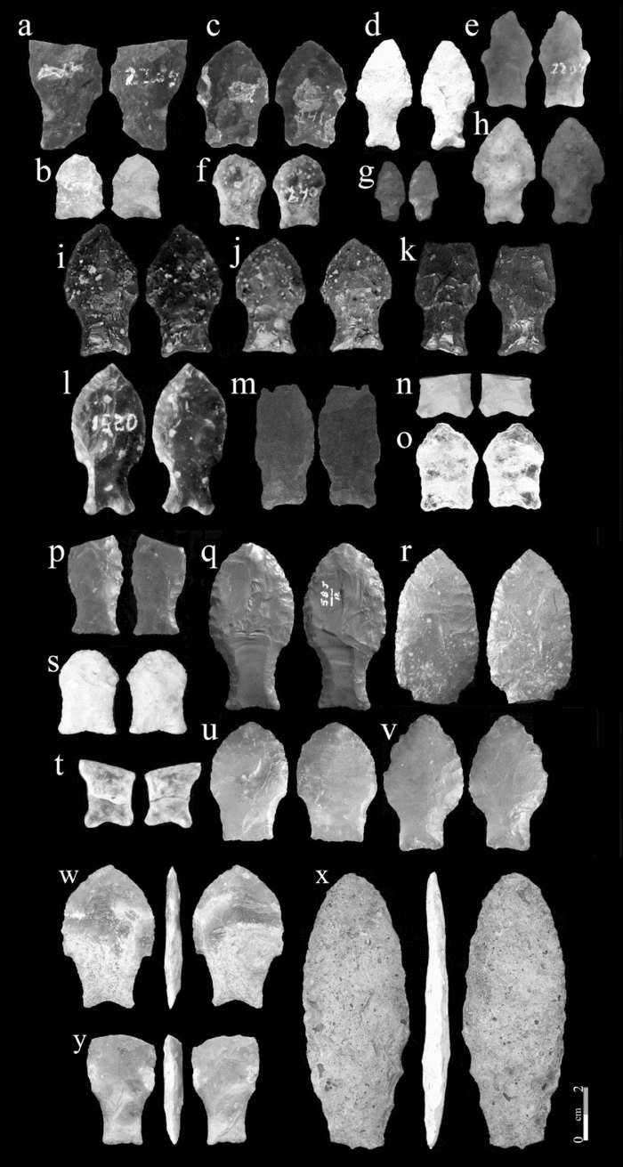
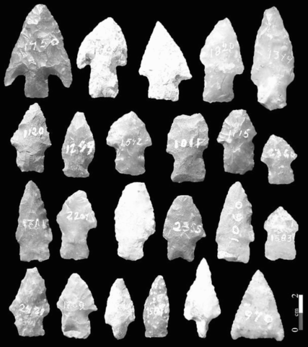
The early-to-mid Holocene period in Uruguay is also poorly understood chronologically. Besides fishtail points (Figure 1), other kinds of preceramic projectile points include lesser-known lanceolate points (Nami Reference Nami2001), stemless triangular points (Hilbert Reference Hilbert1991:Figure 23:10–11; Nami Reference Nami, Farias and Lourdeau2014b:Figure 28 g–h), and stemmed projectile points (Figure 2, First row, left; see also Suárez Reference Suárez2017). Bifacial stemmed points, markers of the Umbu Tradition, are found in southern Brazil and parts of Uruguay and Argentina (Okumura and Araujo Reference Okumura and Araujo2014), although their variation in form has produced typological confusion. Sites where they are found date throughout most of the Holocene (Bueno et al. Reference Bueno, Feathers and Blasis2013; Miller Reference Miller1969; Rodríguez Reference Rodriguez and Meggers1992; Schmidt Dias Reference Schmidt Dias, Bueno and Isnardis2007; Schmitz Reference Schmitz1987). In the high-energy Uruguay River basin, the Laranjito and El Tigre sites yielded Umbu projectile points of diverse shapes (Hilbert Reference Hilbert1985; Miller Reference Miller1987; Suárez Reference Suárez2017). They are coeval with or later than fishtail points, which are also common finds in the area (Capeletti Reference Capeletti2011; Castro and Terranova Reference Castro and Enrique2015; Hilbert Reference Hilbert1991; Loponte and Carbonera Reference Loponte and Carbonera2017; Loponte et al. Reference Loponte, Carbonera and Silvestre2015, Reference Loponte, Okumura and Carbonera2016; Mujica Reference Mujica1995; Nami Reference Nami2007, Reference Nami2017a; Suárez Reference Suárez2015, Reference Suárez2017). Complex alluvial stratigraphy, not to mention vagaries in typology, make interpretations difficult (Butzer Reference Butzer2008; Ferring Reference Ferring, Goldberg, Holliday and Ferring2000; Nami Reference Nami2013:16). Both the Laranjito and El Tigre sites are on river banks, with the latter site affected by high water from dam construction. At Laranjito, older dates come from the lower layer of the riverbank on the alluvial plain, in a test pit dug into the underlying strata. The only excavated portion of the possible terminal Pleistocene layer has dates of ~10.4 and ~9.6 radiocarbon years BP (Miller Reference Miller1987:Figure 16), a problematic age according to Moreno de Sousa (Reference Moreno de Sousa2017:Figure 3). Interestingly, these strata yielded an unrecognized fishtail point illustrated by Miller (Reference Miller1987:Figures 13a, e; see also Moreno de Souza Reference Moreno de Sousa2017:Figure 4A; Nami Reference Nami, Farias and Lourdeau2014b:Figure 26a;). Other bifacial artifacts during this period have been defined but are poorly dated (Nami Reference Nami2017a). Improved typology (Nami Reference Nami2017b, Reference Nami2017c; Okumura and Araujo Reference Okumura and Araujo2014), site formation process studies, and more dating are needed to sort out the technological changes in this period.
Examples of “fisthail” points recovered in the middle Negro River basin. a-b) Los Molles, c-f) Minas de Callorda, g-o) Arroyo Cacique, p) El Puente, q-r) Rincón del Bonete Lake, s) Los Espinillos, t-v) Collares, w-y) Jorge O. Femenías.

Diverse stemmed projectile points with diverse degrees of resharpening found at Los Molles.

Study Area
Uruguay is located within the Pampa biome and is largely characterized by fluvial sediments of the Rio de la Plata basin and of tributaries to the Atlantic. The Rio Uruguay and its principal tributary, the Rio Negro, are the principal drainages. It is a subtropical temperate country with grassy plains, hills, rivers, lagoons, and lowlands (López Mazz Reference López Mazz2013). A large portion of the late Pleistocene/early Holocene landscape is now submerged by the sea level rise that occurred during the Holocene. Although this has, no doubt, drowned many Paleoindian sites, the river valleys provide easy access from the shoreline to the interior and thus contain a substantial Paleoindian and later Holocene record (Figures 1 and 2). As mentioned, a large number of fishtail projectile points have been found (Figure 1), mostly as surface finds or as eroded from river embankments (Bosch et al. Reference Bosch, Femenías and Oliva1980; Nami Reference Nami2017a; Suárez and López Mazz Reference Suárez and López Mazz2003). Few fishtail points are found in stratigraphic context, with an exception being the Urupez II site in southern Uruguay (Meneghin Reference Meneghin2015). Within Uruguay, the largest concentration is in the middle portion of the Rio Negro Basin (Nami Reference Nami2017a), where this study takes place. Many Paleoindian sites are known (e.g., Nami Reference Nami2007, Reference Nami2013, Reference Nami, Farias and Lourdeau2014b, Reference Nami2017a; Nami and Castro Reference Nami and Castro2010, Reference Nami and Castro2014), but few have seen systematic research. Detailed excavations that show stratigraphic relationships of finds are necessary, all the more so because water level fluctuations due to dam construction are causing riverbank sites to erode.
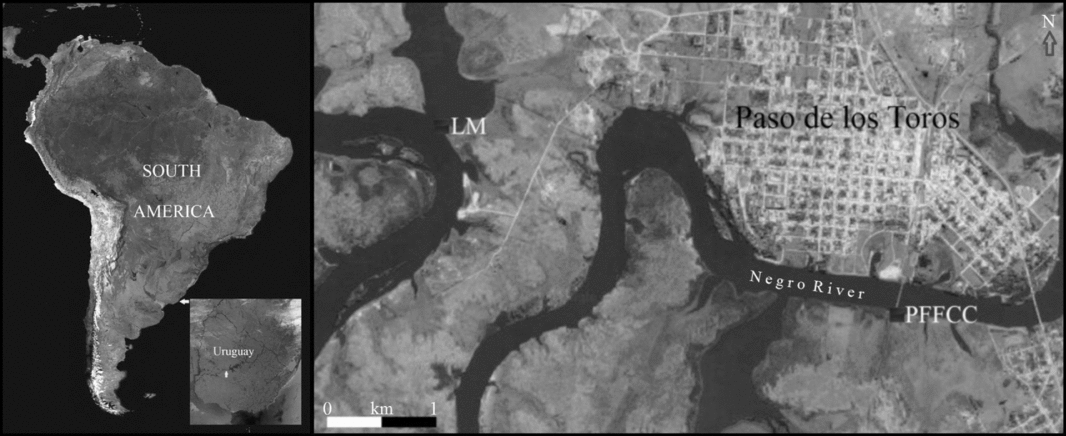
The two sites reported here, Los Molles and Puente del Ferrocarril, are on the banks of the Rio Negro on the outskirts of the city of Paso de los Toros (lat. −32.81, long. −56.50, elev. 64 m; Figure 3). Recent stratigraphic investigations allowed the collection of six OSL samples, three from each site. Archaeological remains include mostly Holocene-aged Umbu-like projectile points, scrapers, and cores, but fishtail points are also abundant (e.g., Nami Reference Nami2013, Reference Nami2017a).
Location of Los Molles (LM) and Puente del Ferrocarril (PFFCC) sites in central Uruguay.

Geological Context
The middle Negro River basin is characterized by undulating low hills of Mesozoic basalts of the Arapey formation (Bossi Reference Bossi1966; Bossi and Navarro Reference Bossi and Navarrro1998). Overlying the basalt bedrock is alluvium of variable thickness, deposited by the meandering river. The Late Pleistocene alluvium is an extensive brown to green sedimentary silt, identified throughout Uruguay. It is generically called the Sopas (Castiñeira et al. Reference Castiñeira, Zárate, Blasi, Fernicola, Puerto, Inda, Bracco, García-Rodríguez, Cocco and Feuillet Terzaghi2010), Sopas-Dolores (Panario and Gutiérrez Reference Panario and Gutiérrez1999), or Dolores Formation (Martínez and Ubilla Reference Martínez, Ubilla, Veroslavsky, Ubilla and Martínez2004), but because such formations show differences in sedimentological composition and tonalities (e.g., Antón Reference Antón1975; Bossi Reference Bossi1966; Martínez and Ubilla Reference Martínez, Ubilla, Veroslavsky, Ubilla and Martínez2004; Ubilla Reference Ubilla1999; Ubilla and Martínez Reference Ubilla and Martínez2016; Ubilla et al. Reference Ubilla, Perea, Lorenzo, Gutiérrez, Rinderknecht and Perea2011, Reference Ubilla, Rinderknecht, Corona and Perea2017), there is no agreement concerning its characterization. Similar deposits in southern Brazil were dated ~12.8–15.0 radiocarbon years BP by Antón (Reference Antón1975). In southern and midwestern Uruguay, radiocarbon dates from bone and wood samples extracted from Sopas-Dolores deposits yielded dates of ~11,600–10,000 radiocarbon years BP (Martínez and Ubilla Reference Martínez, Ubilla, Veroslavsky, Ubilla and Martínez2004; Ubilla Reference Ubilla1999; Ubilla and Martínez Reference Ubilla and Martínez2016; Ubilla et al. Reference Ubilla, Perea, Lorenzo, Gutiérrez, Rinderknecht and Perea2011, Reference Vialou, Benabdelhadi, Feathers, Fontugne and Vialou2017). The Sopas-Dolores deposits show similarities to the Lujanense deposits, which is considered a useful horizon marker for the Late Pleistocene and Early Holocene of the Buenos Aires province, Argentina (Toledo Reference Toledo2011; Tonni et al. Reference Tonni, Huarte, Carbonari and Figini2003). In all three areas, these deposits are similar in fauna composition, including extinct megafauna, and contain the Paleoindian record. All are characterized by biomes of open vegetation (Bombín Reference Bombín1975; Martínez and Ubilla Reference Martínez, Ubilla, Veroslavsky, Ubilla and Martínez2004; Ubilla and Martínez Reference Ubilla and Martínez2016). Overlying the Sopas-Dolores are Holocene deposits of recent alluvium (Antón Reference Antón1975; Bossi Reference Bossi1966; Bossi and Navarro Reference Bossi and Navarrro1998). In some localities overlying the Sopas-Dolores or directly on bedrock is a black clay stratum, probably remnant peats from wetlands that covered much of eastern Uruguay between 10–6.6 radiocarbon years BP (Iriarte Reference Iriarte2006). Such black layers are also noted in Argentina in the Lujanense-Platense transition dated at ~12,000–10,000 radiocarbon years BP (Toledo Reference Toledo2005, Reference Toledo2011; Tonni et al. Reference Tonni, Huarte, Carbonari and Figini2003). The black levels with high organic content suggest a climatic change to humid conditions (Iriarte Reference Iriarte2006; Toledo Reference Toledo2011), a conclusion supported by pollen (Behling et al. Reference Behling, Arz, Patzold and Wefer2002; Iriarte Reference Iriarte2006), diatoms (Moro et al. Reference Moro, de Mattos Bicudo, de Melo and Jair2004), and phytoliths (Iriarte Reference Iriarte2006). Also in the black earth appears anomalous geomagnetic directions, observed in other sites in the southern cone and in other places in the world (Nami Reference Nami2012, Reference Nami2015).
Archaeological Context and Samples
A long-term archaeological project was started in the Rio Negro basin at the end of the 1990s (e.g., Nami Reference Nami2007; Nami and Castro Reference Nami and Castro2010, Reference Nami and Castro2014). This followed some earlier archaeological work (Baeza et al. Reference Baeza, Femenías, Suárez and Florines2001; Taddei Reference Taddei1969), but because of little systematic research in the area, a detailed excavation that clearly showed the stratigraphy of the buried remains was necessary. Several localities and places yielded diverse Paleoindian finds (e.g., Nami Reference Nami2007, Reference Nami2013, Reference Nami2017a; Nami and Castro Reference Nami and Castro2010, Reference Nami and Castro2014). In addition to archaeological research, paleomagnetic investigations are being performed to construct regional curves of paleosecular variations with chronostratigraphic purposes (e.g., Nami Reference Nami2006, Reference Nami2011).
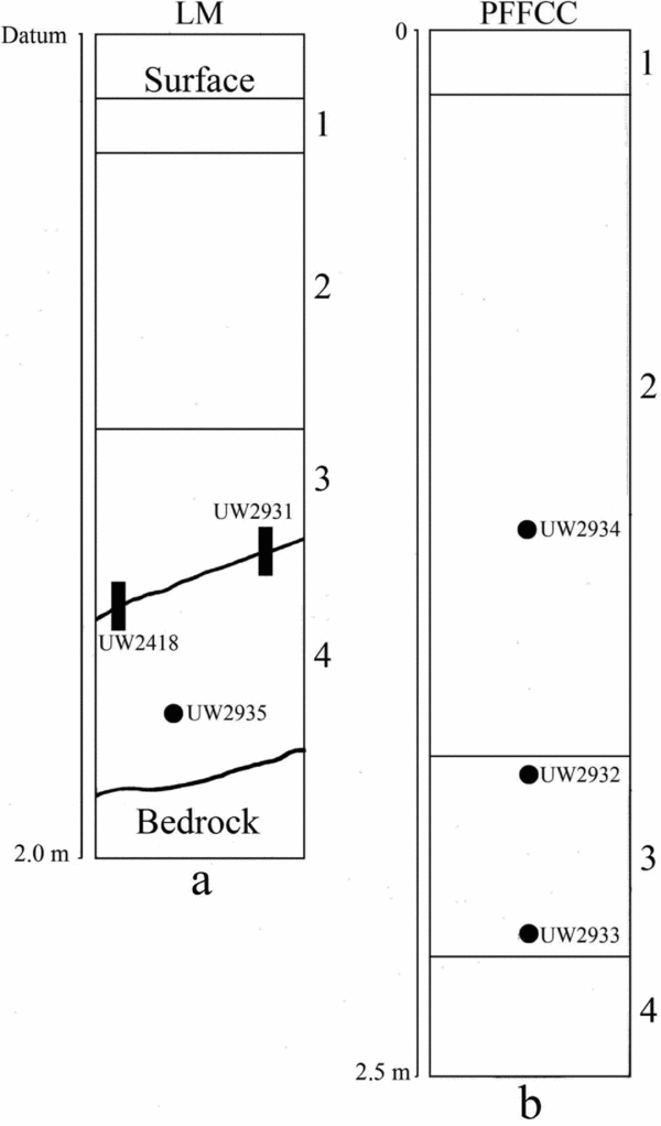
The sites are on the banks of the Rio Negro, and the sediments are mostly fluvial. Los Molles (LM, 32° 48′23.47 S. Lat. 56° 33′ 27.41 W. Long.) is on the current shoreline of the river at the mouth of a creek by the same name on the outskirts of Paso de los Toros city, Tacuarembó Department (Figure 3). Despite alluvial erosion, it still contains intact deposits. Erosion has exposed hundreds of stone artifacts on the shore and underwater (Nami Reference Nami2013, Reference Nami2017b:Figure 2), and among them more than 100 projectile points, two of which can be classified as Fell points (Figures 1a-b and 2). No ceramic remains have been found, indicating a preceramic occupation. Archaeological excavations in progress show four levels of alluvium: 1) the present vegetal humus surface; 2) a gray sandy layer; 3) a sandy-loamy to loamy gray mottled deposit; and 4) a hard brown clay overlying basalt bedrock (Figure 4a). In the excavated portion, thickness of the deposit varies between ~0.40 m and ~1.50 m. Levels 2–3 represent Holocene alluvium and 4 the Sopas-Dolores (Martínez and Ubilla Reference Martínez, Ubilla, Veroslavsky, Ubilla and Martínez2004; Panario and Gutiérrez Reference Panario and Gutiérrez1999; Ubilla and Martínez Reference Ubilla and Martínez2016). At the top of Level 4 appears the relict of a fully developed soil indicating a period of landscape stability (Holliday Reference Holliday1985).
Schematic sections and location of the OSL samples. a) Los Molles, b) Puente del FFCC. The numbers on the right indicate the stratigraphic levels.

Although some artifacts are found in Level 2, the most abundant lithic finds start at ~0.90– 1.00 m. Most prominent are artifact concentrations at ~1.15/1.20 m at the base of level 3 and at ~1.25/1.30 m in the upper part of Level 4. No diagnostic artifacts have been found in the excavations, but the stratigraphy shows technological changes in lithics. In the archaeological upper level from Layer 3, rough unifacial tools locally known as patas de perro (dog's foot), which might be scrapers, and other lithic debitage that suggests a more expedient lithic technology. The lower level yielded fragments of more elaborate unifacial tools, as well as diverse flaking debris, including bifacial thinning flakes that are probably waste from manufacture of bifacial tools (Nami Reference Nami2017b). The lower archaeological level may be attributed to the early Holocene hunter-gatherers who used Umbu-like stemmed projectile points (Figure 2), but earlier Paleoindian material appears to be mixed in (Figure 1a-b). The archaeological remains from Level 3 are attributed to middle Holocene hunter-gatherers. Radiocarbon dates obtained from charcoal samples from Level 2 indicate modern deposition (Nami Reference Nami2013). The archaeological levels contain neither old bone nor charcoal for radiocarbon dating. Instead, a sample of sediment from the upper part of Level 4 at 1.10/1.11 m depth was submitted for AMS dating. A date of 4650 ± 30 radiocarbon BP (KI-5081) was obtained. Employing the OxCal 4.2.4 calibration program (Bronk Ramsey and Lee Reference Bronk Ramsey and Lee2013) and the ShCal13 curve for the Southern Hemisphere (Hogg et al. Reference Hogg, Quan, Blackwell, Mu, Buck, Guilderson, Heaton, Palmer, Reimer, Reimer, Turney and Zimmerman2013), the following ranges of calibrated ages BP were obtained: 5467–5347 (53.9%), 5336–5282 (34.0%), 5164–5136 (4.0%), and 5106–5077 (3.4%) years. These dates can only be considered minimum ages because they represent the apparent mean residence time of the soil (Scharpenseel and Schiffmann Reference Scharpenseel and Schiffmann1977) and include mixing of young and organic carbon (Stein Reference Stein Julie and Holliday1992).
Puente del Ferrocarril (PFFCC, 32° 49′ 20.03 S. Lat. 56° 30′ 48.01 W. Long.) is situated across a railway bridge south of Paso de los Toros in Durazno Department (Figure 3). Nondiagnostic scattered archaeological artifacts are found along the riverbanks eroded by the new course of the river after the dam construction. A sedimentary section about 2–2.5 m thick shows the following layers (Figure 4b): 1) the present vegetal humus surface; 2) a clear brown sandy layer; 3), a dark gray/black clayed stratum, and 4) hard brown clay overlying the basalt bedrock. The latter was tentatively identified as the Sopas-Dolores deposit.
Luminescence Analysis
Procedures
Sample Provenance and Preparation
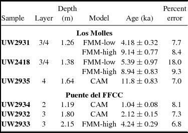
The samples (Table 1) were taken by driving PVC plastic tubes into sediments. At LM, two tubes were vertically inserted into a horizontal section of the archaeological excavation across the Level 3/4 transition in Square I7 at 1.21–1.31 m and 1.34–1.44 m depth from datum. These both ensured mixed samples. In the same grid, a third sample was horizontally taken at ~20 cm below the lower archaeological level at -1.65 m depth. At PFCC, three samples were taken in Layer 2, top of Level 3 in its transition with the overlying strata, and bottom of the dark gray/black strata (3) just above the brown level (4).
Samples and OSL Ages (ka).

Material was removed from the collection container in subdued red/orange light, leaving aside the ends that may have been exposed to light. The latter was used for dose rate measurements. From the unexposed portions, about one-fourth was set aside as an archive, which was also used to measure percent moisture by weight.
Remaining unexposed sediment was first wet sieved through a 90µm screen. The greater-than-90µm fraction was treated with HCl (hydrochloric acid) and H2O2 (hydrogen peroxide), rinsed three times with water and dried. It was then dry sieved to retrieve the 180–212µm fraction. This fraction was etched for 40 minutes in HF (hydrofluoric acid), then rinsed with water, HCl, and water again. After drying, it was passed through the 180µm screen to remove any degraded feldspar. The material caught in the screen was density separated using a lithium metatungstate solution of 2.67 specific gravity. These procedures isolated mainly quartz.
Dose Rate Measurements
Radioactivity was measured by alpha counting in conjunction with atomic emission for potassium (K). Samples for alpha counting were crushed in a mill to flour consistency, packed into acrylic glass containers with ZnS:Ag (zinc sulfide: silver) screens, and sealed for one month before counting. The pairs technique was used to separate the uranium (U) and thorium (Th) decay series. For atomic emission measurements, samples were dissolved in HF and other acids and analyzed by a Jenway flame photometer. K concentrations for each sample were determined by bracketing between standards of known concentration. Conversion to 40K was by natural atomic abundance. Radioactivity was also measured by beta counting, using a Risø low-level beta GM multi-counter system. About 0.5 g of crushed sample was placed on each of four plastic sample holders and counted for 24 hours. The average was converted to dose rate following Bøtter-Jensen and Mejdahl (Reference Bøtter-Jensen and Mejdahl1988) and compared with the beta dose rate calculated from the alpha counting and flame photometer results. Cosmic radiation was determined after Prescott and Hutton (Reference Prescott and Hutton1994). Radioactivity concentrations were translated into dose rates following Guérin and others (Reference Guérin, Mercier and Adamiec2011).
Equivalent Dose Measurements
Grains were placed in special disks for single-grain measurement. Luminescence was measured on a Risø TL-DA-15 reader. Stimulation was by a 532 nm laser delivering 45 W/cm2. Detection was through 7.5 mm U340 (ultraviolet) filters. Exposure was for 0.8s on each grain at 125°C. The first 0.06s were used for analysis and the last 0.15s for background. A preheat of 240°C for 10 seconds followed each dose, except for the calibrating test doses, after which a 200°C cut preheat was employed. The test dose was about 4 Gy. Doses were delivered by a 90Sr (strontium) beta source which provided about 0.08 Gy per second to coarse-grained quartz.
Equivalent dose (De), which is an estimate of the accumulated absorbed dose through time, was determined on single grains using the single-aliquot regenerative dose (SAR) protocol (Wintle and Murray Reference Wintle and Murray2006). The SAR method measures the natural signal and the signal from a series of regeneration doses on a single aliquot. The method uses a small test dose to monitor and correct for sensitivity changes brought about by preheating, irradiation, or light stimulation.
One advantage of single-grain dating is the opportunity to remove grains with unsuitable characteristics from analysis by establishing a set of criteria that grains must meet. Grains were eliminated from analysis if they: (1) had poor signals (as judged from errors on the test dose greater than 40% or from net natural signals less than at least three times above the background standard deviation); (2) did not produce, within 20%, the same signal ratio (often called recycle ratio) from identical regeneration doses given at the beginning and end of the SAR sequence, suggesting inaccurate sensitivity correction; (3) yielded natural signals that did not intersect saturating growth curves; (4) had a signal larger than 10% of the natural signal after a zero dose and visually displayed a declining decay curve, (5) produced a negative De; or (6) contained feldspar contaminates judged visually on growth curves by a reduced signal from infrared stimulation before the OSL measurement, and done after two doses to lend confidence that the reduction in signal is due to feldspar contamination.
A dose recovery test was done on 100 grains from UW2418. In this test, grains are first set to zero by exposure to the laser for 1 second each at 125°C and then given a known dose. The SAR procedure is then applied to see if this known dose can be obtained. Successful recovery is an indication that the procedures are appropriate.
Age was calculated using a laboratory-constructed spreadsheet based on Aitken (Reference Aitken1985). All given error terms are computed at 1-sigma. Calendar dates are based on years before 2015.
Results
Dose Rate
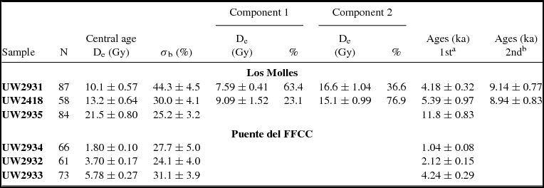
Table 2 gives the concentration of the major radionuclides, and the beta dose rate calculated in the two ways mentioned. The two measures are in statistical agreement for all samples. Total dose rates are also given. Moisture content was estimated at 12 ± 5%, based on measured amounts.
Radioactivity Information.

Note: (a) Beta dose rate differs from Column 5 because of moisture correction.
Equivalent Dose
Measured grains totaled 5136, from which 429, or 8.4%, had acceptable signals, a moderate sensitivity. The vast majority of grains rejected had poor signals.
For dose recovery, of the 100 grains measured, 16 gave an acceptable signal. The ratio of obtained/administered dose was 1.00 ± 0.07, with 94% of the grains yielding values within 2-sigma of the given dose. Over-dispersion was 17.5%. Twenty percent over-dispersion was assumed to be typical of a single-aged sample for the different age models discussed next.
A De value was obtained for each suitable grain. For various reasons, the same value is not obtained for each grain, even if all are the same age. Instead, a distribution is produced. The central age statistical model of Galbraith (Galbraith and Roberts Reference Galbraith and Roberts2012) was used in evaluation of De distributions. The model is used in reference to De and not “age” per se, although dividing the De values by the bulk dose rate provides an “age” for each grain (not accounting for differential dose rates for individual grains). The central age model controls for differential precision by computing a weighted average using log De values. Rather than assuming a single true value, however, it assumes a natural distribution of De values because of nonstatistical sources of variation. It computes an over-dispersion parameter (σb) interpreted as the relative standard deviation of the true De values, or that deviation beyond what can be accounted for by measurement error. For samples of mixed ages, a finite mixture model (Galbraith and Roberts Reference Galbraith and Roberts2012) was employed. This uses maximum likelihood to separate the grains into single-aged components based on the input of a given σb value (20% in this case) and the assumption of a log normal distribution of each component. The model estimates the number of components, the weighted average of each component, and the proportion of grains assigned to each component. The model provides two statistics for estimating the most likely number of components, maximum log likelihood (llik) and Bayes information criterion (BIC).
The natural De distributions are summarized in Table 3. This gives the number of grains for which a De could be derived, the central tendency expressed as the central age model, and the over-dispersion. The samples in Table 3 are arranged in stratigraphic order, top to bottom, for each site. Over-dispersion ranges from 24--44%, somewhat higher than the 20% assumed from dose recovery for a single-aged sample.
De (Gy) Distributions and Components from Finite Mixture Model, and Estimated Ages.

Note: (a) 1st refers either to the first component of the finite mixture model or to the central age model. (b) 2nd refers to the second component of the finite mixture model.
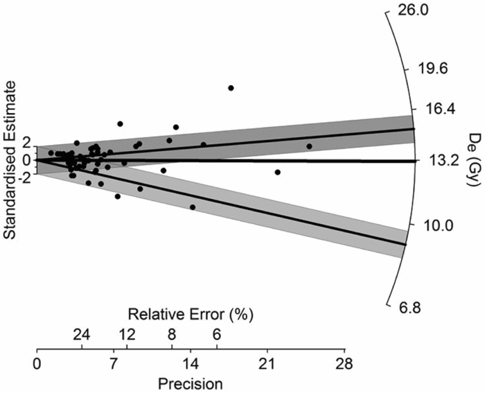
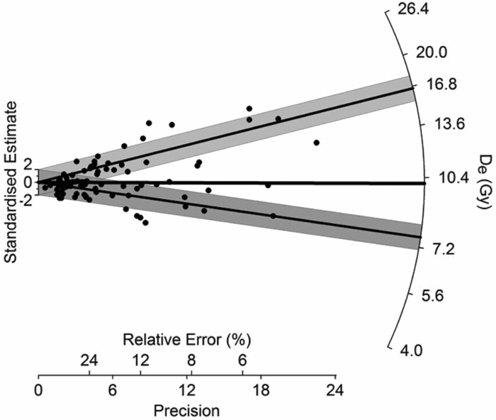
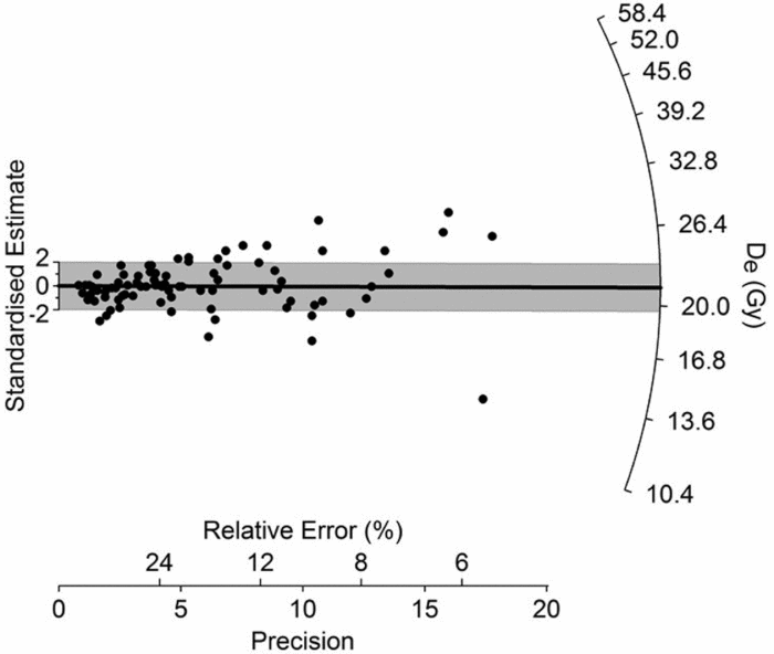
The finite mixture model (FMM) was applied to assess the structure of the data. The results show three of the samples had distributions consistent with a single age. One, UW2933, had 96% of the grains consistent with a single age. The other two, UW2418 and UW2931, appeared more mixed, dividing into two components (Table 3). Both of these samples either straddle the interface between Stratum 3 and Stratum 4 at Los Molles or are close to it. Figures 5 and 6 show radial graphs of the two samples. Radial graphs plot precision (x-axis) against a normalized value of De (y-axis). The normalized values are expressed as the number of standard errors away from some reference value. For example, if the reference is 10 and the value is 14 ± 2, then the normalized value would be 2. Lines drawn from the origin through any point intersect the right-hand scale at the estimated De. Three references were used. One is the solid line representing the central age value. The second is the line within the dark grey shading and represents the component with the highest percentage of grains. The line within the light grey shading represents the smaller component. Shaded areas encompass all points consistent at two standard errors with the value represented by the lines bisecting them. Note that the plot for UW2418 is bimodal with only two points between the two components. This would be expected for a sample straddling two strata, with the younger representing Stratum 3 and the older Stratum 4. The plot for UW2931 is somewhat more scattered, with a smaller percentage of points consistent with the lower stratum, but again consistent with a sample right at the base of Stratum 3. Note that between the two samples, both components are statistically equivalent in value. The clear division between grains for these two samples suggests that the boundary is an unconformity. For comparison, a single-aged sample, UW2935, is graphed in Figure 7.
Radial graphs of UW2418 showing a mixed sample. See the main text for a description of the construction of radial graphs.

Radial graph of UW2931 showing a mixed sample. See the main text for a description of the construction of radial graphs.

Radial graph of UW2935 showing an unmixed sample. See the main text for a description of the construction of radial graphs.

Ages
Table 3 also provides the estimated ages. The ages are derived from the central age model for UW2932, UW2934, and UW2935, and the largest component (96%) for UW2933. Two ages are given for UW2418 and UW2931 because both samples cross a stratigraphic boundary, the first age representing the upper stratum and the second age, the lower.
Discussion
The ages at Los Molles match the expectations of mid-Holocene for Stratum 3 and terminal Pleistocene/early Holocene for Stratum 4. Stratum 4 appears to correspond with the Sopas-Dolores formation, and the dating of UW2935 agrees with radiocarbon ages for this formation in other parts of Uruguay and with ages obtained from archaeological sites with early human occupations (e.g., Austral Reference Austral1982, Reference Austral, Consens, López and Curbelo1995; Hilbert Reference Hilbert1985; López Mazz Reference López Mazz2013; Meneghin Reference Meneghin2004, Reference Meneghin2015; Nami Reference Nami2013; Nami et al. Reference Nami, Florines and Toscano2018; Suárez Reference Suárez2017; among others). These include caves, such as Cueva Amarilla with an uncalibrated radiocarbon date of 10.0 kya (Nami et al. Reference Nami, Florines and Toscano2018), and open-air sites mostly located on riverbanks of important fluvial courses, primarily the Uruguay River to the west. In the open-air sites, such as El Tigre, Pay Paso, and Laguna Canosa, the archaeological finds come from brown silty-sandy-clayed strata compatible with the Sopas-Dolores formations, and radiocarbon dates ranging from the last millennium of the Pleistocene to the transition with the Holocene have been obtained (Suárez Reference Suárez2017:Table 1). At these sites, unifacial tools have been recovered similar to those associated with Fell points (cf. Nami Reference Nami2013:Figure 6; Suárez Reference Suárez2017:Figure 4B-C) and with stemmed projectile points belonging to the Uruguay tradition (Miller Reference Miller1987), or El Tigre and Pay Paso technocomplexes (Suárez Reference Suárez2015, Reference Suárez2017), although this may be typological splitting.
Regarding Fell points, the oldest OSL age at Los Molles is concordant with the dates obtained in other South American localities (11,000–10,000 radiocarbon BP; Maggard and Dillehay Reference Maggard, Dillehay and Dillehay2011; Nami Reference Nami2007, Reference Nami2017a; Nami and Stanford Reference Nami and Stanford2016; Waters et al. Reference Waters, Amorosi and Stafford2015; Yataco Capcha and Nami Reference Yataco Capcha and Nami2016). At Urupez II, in southern Uruguay, artifacts including Fell points were recovered from a reddish pale brown paleosoil formed on the Dolores Formation (Meneghin Reference Meneghin2004), and yielded radiocarbon dates ranging between ~10,700 and 12,000 radiocarbon years BP (Meneghin Reference Meneghin2015). The older dates at this site are older than most radiocarbon dates for Fell points. Close to Los Molles, and also on the shore of the Negro River, Minas de Callorda yielded a similar stratigraphy and archaeological sequence with Umbu-like projectile points from the upper level and a fluted preform found in the lower archaeological level at the top of the brown clay Sopas-Dolores stratum (Nami Reference Nami2007:Figure 3c). In sum, the OSL ages from Los Molles are comparable with ages of early archaeological sites in Uruguay, as well as with well-dated paleontological and paleoecological localities recorded in the Dolores formation in south Uruguay (López Romanelli Reference López Romanelli2012; Lopez et al. Reference López, Femenías and Nami2001; Meneghin Reference Meneghin2016; Ubilla and Martínez Reference Ubilla and Martínez2016).
The two older ages calculated from samples UW2418 and UW2931 agree with early-to-mid Holocene dates for some stemmed Umbu projectile points and similar assemblages recorded in southern Brazil, east of Misiones, Corrientes, and Entre Ríos provinces in northeastern Argentina, and Uruguay (Bueno et al. Reference Bueno, Feathers and Blasis2013; Rodríguez Reference Rodriguez and Meggers1992; Schmitz Reference Schmitz1987; Suárez and López Mazz Reference Suárez and López Mazz2003). The Umbu tradition was initially grouped into several phases, according to supposed differences in the stemmed projectile points (Schmitz Reference Schmitz1987), but this probably just reflects, besides temporal differences, the broad variety of stemmed points in southern Brazil and Uruguay. An important shared technological feature of points from these sites is the wide variety of beveled edges, which are rare in South American archaeology (Nami Reference Nami2017c). In several published images, it is possible to observe this feature both in El Tigre (Suárez and López Mazz Reference Suárez and López Mazz2003; Suárez Reference Suárez2015, Reference Suárez, Piñeiro and Barceló2017:Figure 6C) and Pay Paso points (Suárez Reference Suárez2017:Figure 5E). For example, specimens similar to El Tigre points exist in the Vinitu and Rio Pardinho phases of the Umbu Tradition (Schmitz Reference Schmitz1987:Figures 16k–l, 18 and 19b), a fact also observable with the Pay Paso points, mainly in stem shape (Schmitz Reference Schmitz1987:Figures 18–19). Another significant technological feature shared by the El Tigre technocomplex and the Umbu assemblage in general, is refined bifacial reduction for manufacturing delicate stemmed and unstemmed bifaces. Observed also in fishtail point bifacial thinning (Nami Reference Nami2013, Reference Nami, Farias and Lourdeau2014a), an unusual (for South America) thinning strategy employed in both archaeological constructs, is the use of edge-to-edge and overshot method sometimes used for making beveled edges (Miller Reference Miller1969:Figure 6g; Nami Reference Nami2017c:Figure 3c, 19; Schmitz Reference Schmitz1987:Figure 16c). Waste products from this process are found at El Tigre (Suárez et al. Reference Suárez, Piñeiro and Barceló2017:Figure 8a) and other places in Brazil and Uruguay (Miller Reference Miller1969:Figure 8j, m; Nami Reference Nami2017c:Figure 20).
For samples UW2918 and UW2931 the two ages, separated by 3.55 to 4.96 ka, respectively, reflect a geological unconformity as suggested by the relict of the fully developed soil on the upper portion of Level 4. The few regional archaeological buried records obtained from sedimentary sequences also show episodic sedimentation and contain unconformities (Baeza et al. Reference Baeza, Femenías, Suárez and Florines2001; Nami Reference Nami2007). The youngest OSL dates from both samples are consistent with the minimum age obtained from the soil with AMS dating at the top of Level 4. As an additional component of the local chronostratigraphical framework, the earliest date at Puente del FFCC agrees with the ages for Stratum 3 at Los Molles. This sample lies just above the suspected Sopas-Dolores formation. If our suspicion is correct, then there is an unconformity reflecting no sedimentation for several thousand years. The later dates reflect a younger record that is missing at Los Molles and poorly known in the Middle Negro in general. They may also provide a local age for wetland deposits observed in other areas in Uruguay during the middle Holocene.
Conclusion
Luminescence dating provides reasonable Late Pleistocene and Holocene ages for sedimentary sequences at two sites in Uruguay. The chronology of the preceramic record in Uruguay is poorly known, despite its importance for human colonization studies. Our results, for a start, show that luminescence dating can play an important role in resolving this chronology. The analytical procedures also correctly distinguished mixed samples collected across an unconformity. This should prove useful in assessing stratigraphic integrity, which is so important for early sites, especially in Uruguay, a territory crossed by a myriad of diverse fluvial courses (Praderi et al. Reference Praderi, Vivo and Praderi2006).
Acknowledgements
We are indebted to CONICET and UBA for supporting our investigations; Museo Nacional de Antropología de Uruguay for having sponsored the archaeological research in this country; A. Florines and A.Toscano, for their constant support and help during the investigations at the Negro River; W. Aizpún for permitting documentation of his projectile point collection from Los Molles site; and S. Bálsamo for his logistic support and help during the sampling at PFFCC.
Data Availability Statement
The luminescence raw data and analyses are stored at http://dagorlad.anthropology.washington.edu/~ftpuser. Click on “Rock Alignment Dating,” and find a document called “Uruguaydata.docx”. This will guide you to the other files that are also found under “Rock Alignment Dating.”