INTRODUCTION
Megadroughts, or extreme droughts that persist for years to decades, can have a severe impact on water resources, ecosystems, agriculture, and human populations (Cullen et al., Reference Cullen, deMenocal, Hemming, Hemming, Brown, Guilderson and Sirocko2000; deMenocal, Reference deMenocal2001; Stahle et al., Reference Stahle, Falko, Cook and Griffin2007; Dai, Reference Dai2011; Stambaugh et al., Reference Stambaugh, Guyette, McMurry, Cook, Meko and Lupo2011). Arid regions are especially vulnerable to megadroughts, both because of the limitation of water resources and the large role climate has on geomorphic processes and ecosystem services. There has been much work on the cause and frequency of megadroughts over the last decade, initiated in part by the severe droughts that have affected many parts of the world and simulations of future climate that suggest warming and drying in many of these regions will continue and amplify (Cook et al., Reference Cook, Seager, Cane and Stahle2007; Cook et al., Reference Cook, Anchukaitis, Buckley, D’Arrigo, Jacoby and Wright2010; Woodhouse et al., Reference Woodhouse, Meko, MacDonald, Stahle and Cook2010; Fawcett et al., Reference Fawcett, Werne, Anderson, Heikoop, Brown, Berke, Smith, Goff, Donohoo-Hurley, Cisneros-Dozal, Schouten, Damasté, Huang, Toney, Fessenden, WoldeGabriel, Atudorei, Geissman and Allen2011). In some areas, such as the Fertile Crescent region of the Middle East, there is evidence that recent long-term drought has already had a profound impact on water resources and political stability (Hsiang et al., Reference Hsiang, Burke and Miguel2013; Gleick, Reference Gleick2014; Kelley et al., Reference Kelley, Mohtadi, Cane, Seager and Kushnir2015; Schleussner et al., Reference Schleussner, Donges, Donner and Schellnhuber2016).
In many arid and semiarid environments, the frequency and magnitude of past droughts have been reconstructed with tree-ring chronologies (e.g., Cook et al., Reference Cook, Seager, Cane and Stahle2007; Stahle et al., Reference Slota, Jull, Linick and Toolin2007; Cook et al., Reference Cook, Anchukaitis, Buckley, D’Arrigo, Jacoby and Wright2010; Woodhouse et al., Reference Waters and Haynes2010), lacustrine records (Metcalfe et al., Reference McRostie, Gayo, Santoro, Pol-Holz and Latorre2010; Fawcett et al., Reference Euler, Gumerman, Karlstrom, Dean and Hevly2011; Morgan and Pomerleau, Reference Minvielle and Garreaud2012), and analysis of dune field activity (Forman et al., Reference Forman, Marin, Gomez and Pierson2001; Tripaldi and Forman, Reference Standen, Santoro, Arriaza and Coleman2007; Forman et al., Reference Fawcett, Werne, Anderson, Heikoop, Brown, Berke, Smith, Goff, Donohoo-Hurley, Cisneros-Dozal, Schouten, Damasté, Huang, Toney, Fessenden, WoldeGabriel, Atudorei, Geissman and Allen2008). These histories of megadroughts can then be used to assess the synoptic climatic controls leading to extreme droughts and to try to predict future drought frequency and intensity (e.g., Seager et al., Reference Schumm and Hadley2008; Seager et al., Reference Seager, Burgman, Kushnir, Clement, Cook, Naik and Miller2009; Woodhouse et al., Reference Waters and Haynes2010; Nelson et al., Reference Mujica, Latorre, Maldonado, González-Silvestre, Pinto, De Pol-Holz and Santoro2011). In most arid lands, however, where societies are at great risk to sustained droughts, it is generally not possible to use many of these proxies to infer past droughts because of the lack of available trees and lakes. Large dune fields do occur in many arid and hyperarid regions, but there are also vast expanses of arid and semiarid lands that lack dune fields.
In-stream wetland deposits, which are found in many deserts around the world, are key archives of past environmental change (Rech et al., Reference Rech2017). As these systems are susceptible to hydrologic droughts that lower the regional water table, in-stream wetland deposits might constitute another archive of past megadroughts. In-stream wetlands occur in streams with an emergent water table that experience few large discharge events per year (Zierholz et al., Reference Zhou and Lau2001). Streambeds contain dense stands of riparian vegetation that armor the streambed, making it highly resistant to erosion (Prosser and Slade, Reference Placzek, Quade and Patchett1994a; Houston, Reference Hogg, Hua, Blackwell, Niu, Buck, Guilderson, Heaton, Palmer, Reimer, Reimer, Turney and Zimmerman2005). Removal of this vegetation by either natural or anthropogenic environmental changes, however, may initiate channel incision (Prosser and Winchester, Reference Prosser and Slade1996).
In this study, we investigated the potential of using well-preserved in-stream wetland sequences to reconstruct a history of Holocene megadroughts in the northern Atacama Desert. Parts of Chile have been influenced by a sustained drought since 2010 (CR2, 2015; Garreaud et al., Reference Garreaud, Alvarez-Garreton, Barichivich, Boisier, Christie, Galleguillos and LeQuesne2017), and models of future climate have predicted increased temperatures and reduced precipitation for many sectors of the Andes (Urrutia and Vuille, Reference Urrutia and Vuille2009; Minvielle and Garreaud, Reference Minvielle and Garreaud2011). Therefore, proxies to reconstruct the frequency, magnitude, and cause of past droughts are critical. To test the use of in-stream wetlands as a proxy for megadroughts, we examined in-stream wetland deposits preserved as terraces along a 4.3 km reach of the Río San Salvador in the Atacama Desert of northern Chile. Radiocarbon dating of extremely well-preserved carbonized plant fragments and amino-acid racemization of aquatic gastropod shells were used to constrain the age of deposits. Reconstructed periods of aggradation and incision of the in-stream wetlands along Río San Salvador are then compared with other in-stream wetland deposits and paleoclimatic proxies in the Atacama Desert between 19°S and 25°S. These comparisons were then used to determine if in-stream wetland deposits can be used to reconstruct the history of megadroughts in this region and to infer potential climatic controls on sustained drought. This history of extreme droughts is then compared with the archaeological record and paleodemographics to ascertain the relations between climate change and societal instability. As ongoing global climate change is becoming an increasingly important concern regarding the availability of water resources in arid lands, it is important to understand the past variability of these systems to better manage future water resources (Milly et al., Reference Milly, Betancourt, Falkenmark, Hirsch, Kundzewicz, Lettenmaier and Stouffer2008).
STUDY AREA
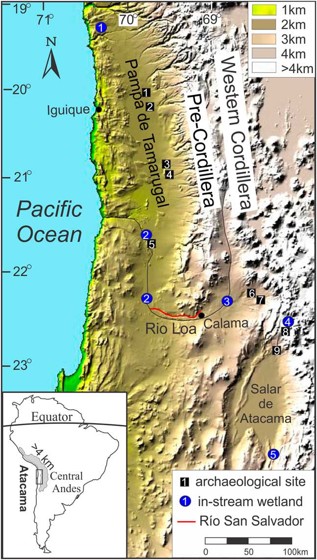
The Atacama Desert, situated in northern Chile between the Pacific Ocean and the Andes, is one of the driest regions on Earth (Fig. 1). Hyperaridity in the Atacama Desert results from the interaction between the strong temperature inversion along the Pacific Coast to the west and the high Central Andes to the east. The temperature inversion results from the cool ocean waters of the Humboldt Current in conjunction with the dry, subsiding air of the Southeastern Pacific Anticyclone (Houston, Reference Houston2005). As the cool, moist air at the surface cannot rise because of the warmer and drier air above, moisture entrained in air masses over the Pacific rarely penetrates inland into the desert. The high Central Andes limits easterly moisture from the South American monsoon system (SAMS) sourced in the Amazon and Gran Chaco from entering the Atacama in the summer months (Zhou and Lau, Reference Zhou and Lau1998; Houston and Hartley, Reference Houston and Hartley2003; Vuille and Keimig, Reference Vuille and Keimig2004).
(color online) Location of the Río San Salvador in the Atacama Desert, Chile, along with in-stream wetland deposits and archaeological sites used to reconstruct a history of extreme droughts and the response of societies. In-stream wetland sites include Quebrada Tana (1), Río Loa (2), Río Salado (3), Quebrada Puripica (4), and Río Tulán (5). Archaeological sites include Pircas and Caserones (1), Tarapaca (2), Guatacondo and Ramaditas (3), Maní (4), La Capilla (5), Topain and Paniri (6), Turi (7), Puripica (8), and Tulor (9).

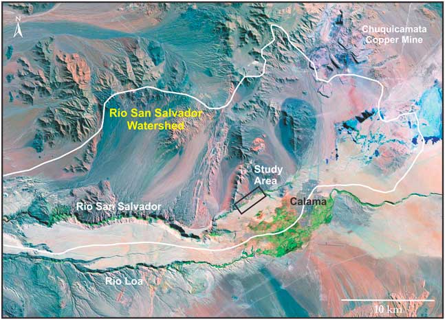
The Río San Salvador begins north of the city of Calama and just to the south of the vast copper mine Chuquicamata, and it flows west until it joins the Río Loa approximately 75 km downstream (Figs. 1 and 2). The stream has a catchment area of ~600 km2 that includes the southwestern portion of the Cordillera Domeyko, or pre-Cordillera, and the northern portion of the Calama basin. The elevation of the catchment ranges from ~3500 m in the Cordillera Domeyko to ~1200 m where the Río San Salvador intersects the Río Loa. The elevation of the stream channel in the study area is ~2175 m. The upper portion of the stream, where the study area is located, is situated just above a large groundwater sapping head-cut separating the upper reach from the deeply incised (~400 m) lower reach just west of the study area (Fig. 2).
(color online) The Río San Salvador catchment along the western margin of the Calama basin and the location of the study area.

The Calama basin, located between 22 and 23°S in the east-central Atacama, is extremely arid, receiving on average 3.3 mm/yr based on precipitation records from 1965 to 2010 (DGA, 2012). The limited rainfall in this region of the Atacama Desert derives from three main sources. Summer convective precipitation originates either in the Amazon basin to the northeast or at the La Plata basin’s Gran Chaco to the southeast (Garreaud, Reference Garreaud1999; Garreaud et al., Reference Garreaud, Vuille and Clement2003; Vuille and Keimig, Reference Vuille and Keimig2004; Vuille et al., Reference Vuille, Burns, Taylor, Cruz, Bird, Abbott, Kanner, Cheng and Novello2012). Precipitation caused by frontal systems associated with extratropical cyclones can also occur during the austral winter (Vuille, Reference Vuille1999). The Calama basin is sensitive to El Niño/Southern Oscillation (ENSO) variability (Houston, Reference Houston2006). During El Niño events, warmer sea surface temperatures in the eastern Pacific Ocean limit the upwelling of cold, nutrient-rich bottom waters and the creation of cool, moist air near the coast. The reduction of the coastal temperature inversion allows some moisture into the western margin of the Atacama, but this moisture generally does not penetrate into the east-central desert (McKay et al., Reference McKay, Friedman, Gomez-Silva, Caceres-Villanueva and Andersen2003). Strong upper-air (200 hPa) westerly winds during El Niño events also deprive the eastern Atacama and Altiplano of moisture from the east, causing drought conditions in these regions (Houston, Reference Houston2005). In contrast, during La Niña conditions, precipitation is enhanced along the Andean Altiplano and the eastern edge of the Atacama, as stronger easterly winds advect moist air masses from the Amazon (or Gran Chaco) across the Andes and into the eastern Atacama (McKay et al., Reference McKay, Friedman, Gomez-Silva, Caceres-Villanueva and Andersen2003; Vuille and Keimig, Reference Vuille and Keimig2004). The increased magnitude and frequency of ENSO variability throughout the Holocene may have caused more severe droughts and increased aridity (Moy et al., Reference Moy, Seltzer, Rodbell and Anderson2002; Rein et al., Reference Rein, Luckge, Reinhardt, Sirocko, Wolf and Dullo2005).
METHODS AND MATERIALS
Stratigraphy and mapping
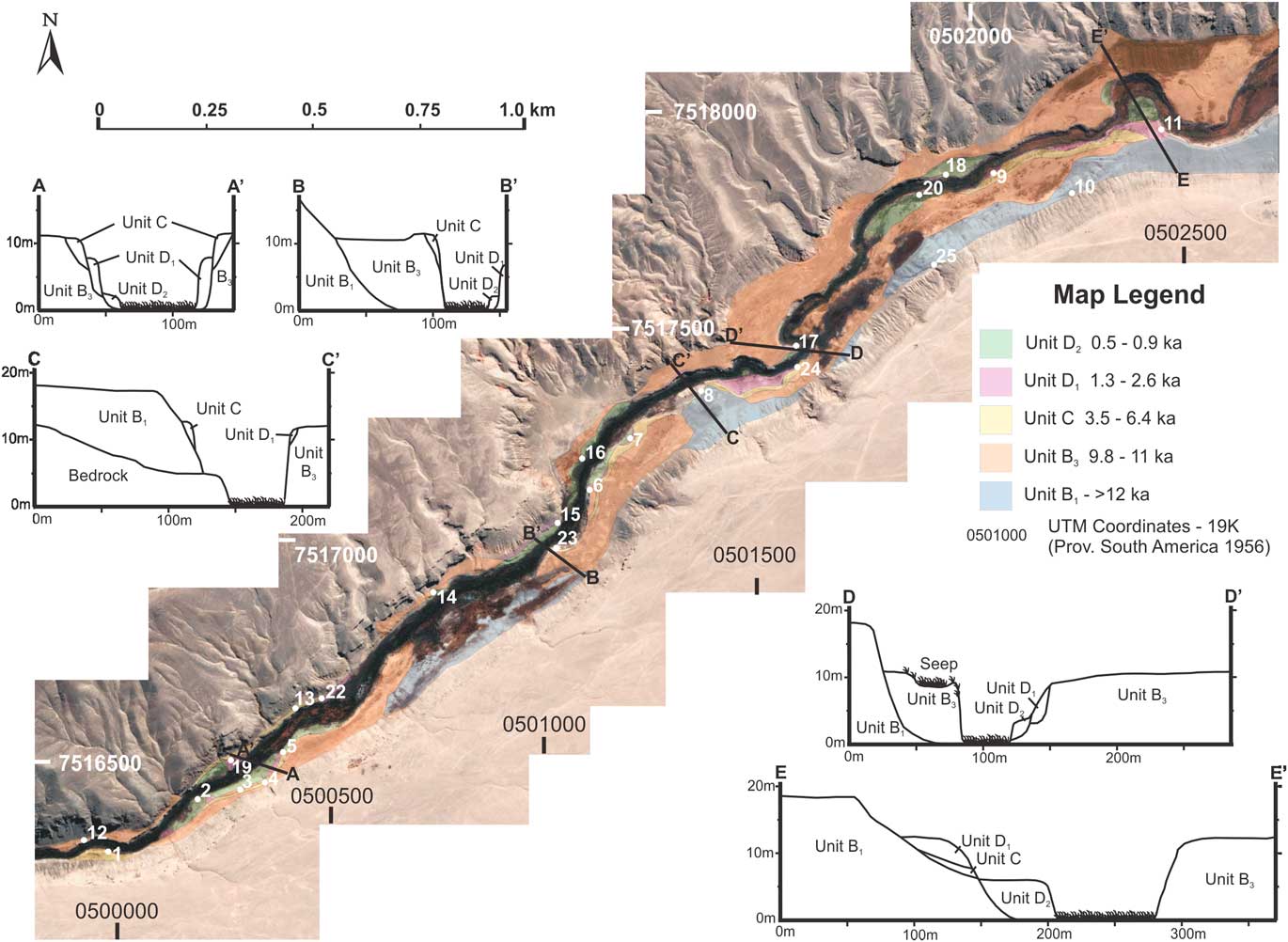
A 4.3-km stretch of the Río San Salvador with well-preserved in-stream wetlands was selected immediately downstream of the city of Calama, Chile (Fig. 3). A surficial geologic map of this section of the stream was produced from sedimentologic descriptions and geochronology of 17 stratigraphic sections and five valley cross sections. The ages of stratigraphic units were constrained by mapping crosscutting stratigraphic relationships and by 37 radiocarbon ages on samples of carbonized plant fragments and organic-rich sediments (Fig. 3). Wherever possible, samples were collected from the top and bottom of each stratigraphic unit to constrain the ages of the deposits. Samples of aquatic Hydrobiidae gastropod shells were also collected and analyzed for amino-acid racemization (AAR) to constrain the age of the oldest stratigraphic unit that lacked organic material.
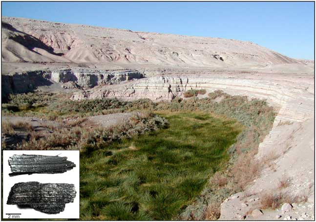
(color online) In-stream wetlands along Río San Salvador and terraces of in-stream wetland deposits. Inset shows carbonized plant fragments, isolated from an organic mat, used for radiocarbon dating.

Geochronology
Carbonized plant fragments and organic-rich sediments were converted into accelerator mass spectrometry (AMS) graphite targets for 14C dating and aliquots of carbon dioxide for δ13C analysis at Miami University. Samples were pretreated using the acid-base-acid method using 2N HCl and 2% NaOH. Each treatment lasted ~24 hours. Samples were then placed in break seal tubes with cupric oxide and silver, evacuated on a vacuum extraction line, and combusted at 900°C. The combusted gas was purified cryogenically, and the resulting CO2 was split into two aliquots. One aliquot was converted to graphite by catalytic reduction of CO (modified after Slota et al., Reference Slota, Jull, Linick and Toolin1987) and submitted to the University of Arizona–National Science Foundation AMS facility for 14C analysis. The second aliquot was submitted for δ13C analysis in order to correct the measured 14C activity for isotopic fractionation. The resulting 14C ages were calibrated using the Southern Hemisphere calibration curve (SHCal13) and OxCal 4.3 (Hogg et al., Reference Hogg, Hua, Blackwell, Niu, Buck, Guilderson, Heaton, Palmer, Reimer, Reimer, Turney and Zimmerman2013; Ramsey and Lee, Reference Ramsey and Lee2013). Ages are presented in calibrated years BP (before present; 0 yr BP=AD 1950) or thousands of calibrated years BP (ka), and uncertainties represent 1σ. When discussing the archaeological literature, calibrated ages are also reported in BC/AD. Calibrated ages are present with 1σ errors for correlation with regional archaeological records.
AAR was used to constrain the age of the oldest stratigraphic unit mapped that lacked organic material and therefore could not be dated with radiocarbon. Thirty fossil shells—six samples of five individual shells of Hydrobiidae aquatic gastropods—were analyzed at the Amino Acid Geochronology Laboratory at Northern Arizona University following standard procedures (Kaufman and Manley, Reference Kaufman and Manley1998). Four of the samples were from units of known age and were used to construct an age model, whereas two samples were from the oldest unit of unknown age. Shells were cleaned by acid leaching, demineralized, and then analyzed using reverse phase liquid chromatography. For this study, only aspartic and glutamic acid data were used because they span the range of racemization rates, are the most abundant in shell protein, and are most precisely resolved by reverse phase liquid chromatography (Kaufman and Manley, Reference Kaufman and Manley1998; Kosnik et al., Reference Kosnik, Kaufman and Hua2008).
RESULTS AND DISCUSSION
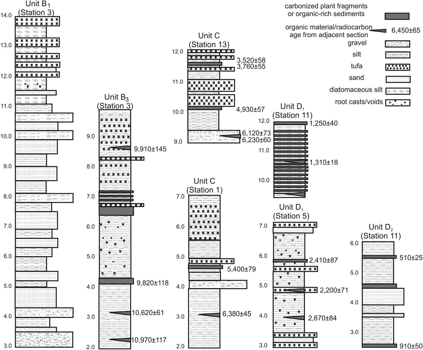
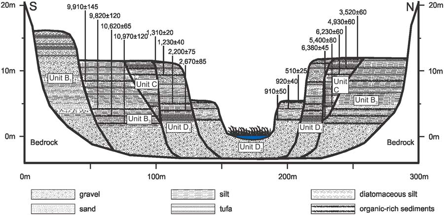
The surficial mapping, measurement, and description of exposed sections at Río San Salvador identified multiple inset units of in-stream wetland deposits (Figs. 4 and 5). Units generally contain fine sands and silts, white diatomaceous silts, organic mats, and tufa deposits, which represent in-stream wetland conditions similar to the modern environment (Fig. 3). A few units contain imbricated gravels and cross-bedded sands, especially at the base of sections, indicative of alluvial channel deposits at the onset of unit filling episodes. Valley-fill deposits gradually thicken upstream within the study area and end abruptly at the downstream terminus of the study area where the canyon becomes deeply incised into bedrock.
Representative stratigraphic sections from the study area (ages are in cal yr BP).

(color online) Map of the stratigraphic units for in-stream wetland deposits along with cross sections from the Río San Salvador study area.

Geochronology
Radiocarbon dating
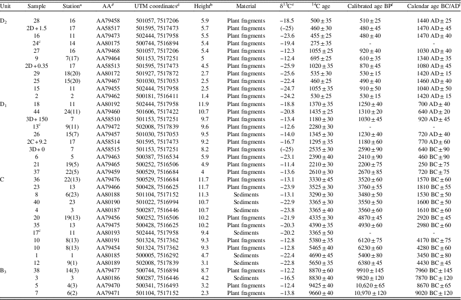
A total of 37 radiocarbon ages processed from collected organic samples constrain the age of in-stream wetland units (Table 1). Thirty of the radiocarbon ages are derived from carbonized plant fragments collected from organic-rich lenses referred to as black mats (Fig. 3). Seven samples of bulk organic material were dated from organic-rich sediments as no plant fragments were identified in these samples. Radiocarbon ages of all samples range from ~11,000 to ~500 yr BP, providing an excellent record of distinct depositional units and subsequent periods of incision throughout the Holocene.
Radiocarbon ages.

a Parentheses indicate corresponding stratigraphic column.
b Above modern stream level.
c Problematic dates given known stratigraphy.
d UTM coordinates based on Provisario S.A. 1956.
e Parentheses on δ13C values denote assumed values.
f OxCal 4.3 (Bronk Ramsey and Lee, Reference Ramsey and Lee2013), SHCal13 Southern Hemisphere (Hogg et al., Reference Hogg, Hua, Blackwell, Niu, Buck, Guilderson, Heaton, Palmer, Reimer, Reimer, Turney and Zimmerman2013). Calibrated ages are reported as the mean of the calibrated range±1 standard deviation.
Three radiocarbon ages (samples 13, 17, and 24) do not fit within the sequence of aggradation relative to their respective time-stratigraphic unit (Table 1). Sample 13, a carbonized plant fragment, yielded a 14C age of 2280±30, which is ~1000 yr older than other ages of approximately the same height above stream level in unit D1. This erroneous age may be the result of reworking of organic material from older stratigraphic units. Sample 17, an organic-rich sediment, returned a 14C age of 3365±50 yr BP, which is ~2000 yr younger than other samples of the same height in unit C. This erroneous younger age may be attributable to contamination by younger sediments or more likely by the growth of secondary vegetation and roots. Sample 24 from unit D2 yielded a 14C age of 275±35 yr BP, which is ~200 yr younger than the other three 14C ages from the top of unit D2. This age is thought to be influenced by secondary vegetation.
AAR
Average aspartic acid racemization ratios (DL Asp) increased with age progressively for the fossil shells of known age, ranging from 0.228±0.014 for shells that were ~500 yr old to 0.416±0.016 for shells that were ~5400 yr old (Supplementary Table 1, Supplementary Fig. 1). The two samples of unknown age yielded average DL Asp values of 0.578±0.041 and 0.620±0.025. Average glutamic acid racemization ratios (DL Glu) also increased with age for the fossil shells of known age, yet there was overlap in average ratios for samples of different age (Supplementary Table 1, Supplementary Fig. 1). For example, shells that were ~500 yr old and those that were ~935 yr old had similar values of 0.098±0.012 and 0.097±0.006, and shells that were ~2400 and ~5400 yr old had similar values of 0.133±0.011 and 0.129±0.021 (Supplementary Table 1). The two samples of unknown age had higher values of 0.394±0.088 and 0.444±0.071. Interpretation of the relative age of the two unknown samples is discussed subsequently in the context of stratigraphic age constraints.
Stratigraphic units
The identification of stratigraphic disconformities, the differences in relative heights above stream level, and differences in hardness and sedimentary facies allowed for the identification of several time-stratigraphic units in the field during initial mapping. Subsequent radiocarbon dating of these deposits indicated that there were a total of five inset stratigraphic units (units B1, B3, C, D1, and D2) within the study area (Figs. 4 and 5). The valley cross sections constructed in the field highlight the complex relationships of these inset units, especially as units B3, C, and D1 are all approximately the same height above the modern stream level (~12 m). Naming of these units adheres to the stratigraphic nomenclature used by other studies (Rech et al., Reference Rech, Quade and Betancourt2002; Rech et al., Reference Rech, Pigati, Quade and Betancourt2003; Quade et al., Reference Quade, Rech, Betancourt, Latorre, Quade, Rylander and Fisher2008) to describe in-stream wetland and groundwater discharge deposits in the Atacama.
Unit B 1
This unit outcrops along the southern bank of the study area and is preserved as a thick, high (~18 m above modern stream level), and nearly continuous terrace that unconformably underlies all younger deposits (Figs. 4, 5, and 6). There are no 14C ages from this unit as no organics were identified. A minimum age for these deposits is provided by the basal age of unit B3 that is inset within unit B1, which has an age of 10,970±117 yr BP. Average aspartic and glutamic amino acid ratios for gastropod shells from this unit are much higher than samples of known age between 500 and 5400 yr (Supplementary Table 1, Supplementary Fig. 1). A linear age model for DL Asp3 was constructed as aspartic acid showed a progressive increase with sample age. Estimated ages for the two samples of aquatic gastropods were ~15 and ~12 ka (Supplementary Fig. 1). We tentatively assign these deposits to the time-stratigraphic unit of B1 (Quade et al., Reference Quade, Rech, Betancourt, Latorre, Quade, Rylander and Fisher2008), which dates from ~17 to 14 ka. Unit B1 is composed of alternating beds of poorly sorted imbricated gravels and well-sorted sands and silts that are ~20–50 cm thick in the lower portion of the section, indicative of sustained stream discharge. Thinly bedded silts, sands, tufa, and diatomaceous silts representing in-stream wetlands characterize the upper 3 m of the unit.
(color online) Generalized stratigraphic sequence from Río San Salvador (ages are in cal yr BP).

Unit B3
Unit B3 is the second oldest unit, with four radiocarbon ages derived from plant macrofossils and organic-rich sediments yielding ages ranging from 10,970 to 9820 yr BP. Unit B3 is the most prevalent unit in the study area (Fig. 5), but good vertical exposures are limited because of infilling by younger units. Unit B3 unconformably overlies unit B1, but the top of the unit is approximately 12 m above the active stream channel in most areas, approximately 6 m lower than unit B1. Unit B3 is composed primarily of pink and tan silts and organic-rich sediments but lacks imbricated gravels and well-sorted sands that are prevalent in unit B1. Cemented tufa is found toward the top of the unit in many sections, yet it is more discontinuous than the tufa beds in unit B1. Numerous root voids and carbonate rhizoconcretions are present. The pink and tan silts represent flood/sheetwash deposits, whereas the organic units and tufas represent low-energy in-stream wetlands.
Unit C
Unit C is inset within unit B3. Twelve radiocarbon ages of plant fragments and organic-rich sediments yield ages ranging from 6380 to 3480 yr BP (Table 1). Unit C is found throughout the study area on both banks of Río San Salvador, and it is the stratigraphic unit most commonly exposed in vertical cuts in the southern portion of the study area. However, on the northern bank of Río San Salvador, unit C is only exposed in the western portion of the study area. Many outcrops of unit C reach approximately 12 m above the active stream surface. Well-sorted silts and imbricated poorly sorted gravels form the lower portion of unit C, whereas silty sediments, organic units, and numerous tufa layers representing in-stream wetlands occupy the upper portion of the unit.
Unit D 1
Unit D1 is constrained by 10 radiocarbon ages of plant macrofossils ranging from 2610 to 1180 yr BP, with most plant macrofossils at the top of the unit dating between 1310 and 1230 yr BP (Table 1). Unit D1 is preserved as isolated patches throughout the study area on both sides of the Río San Salvador. The top of unit D1 varies in elevation but in some areas reaches ~12 m above the modern stream channel. Unit D1 is inset within both units B3 and C (Fig. 5). Unit D1 is easily identifiable from the other units at Río San Salvador because of the chocolate brown color of organic-rich silts that comprise most of the unit. The unit also contains pink tufa layers, sandy lenses, and root voids with rhizoconcretions. In general, the deposits are characteristic of low-energy in-stream wetlands.
Unit D 2
Unit D2 unconformably overlies unit D1, making it the youngest stratigraphic unit. Eleven radiocarbon ages derived from plant macrofossils yield ages ranging from 920 to 480 yr BP (Table 1). Unit D2 is a well-preserved low terrace about 2–6 m above the active stream channel, proximal to the present channel. The unit noticeably thickens upstream, reaching up to 6 m at the east end of the study area. Unit D2 is composed of poorly sorted and bioturbated silts and sands, with abundant organic material found throughout the unit. These deposits are characteristic of low-energy in-stream wetlands.
Synthesis of the Río San Salvador stratigraphy
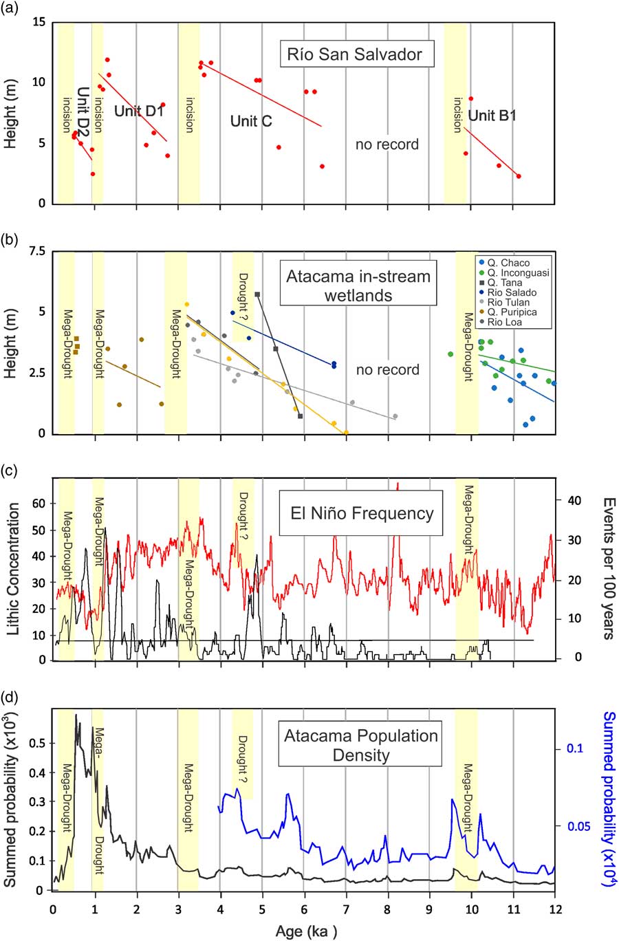
The presence of multiple stratigraphic units, bounded by stratigraphic disconformities and with a robust 14C age control on carbonized plant fragments, allows for the reconstruction of the age of in-stream wetlands and the timing of major incision events (Fig. 6). The oldest in-stream wetland unit, unit B1, is interpreted to represent the wettest conditions in the sequence as suggested by the height of the deposits above stream level (~18 m), the continuous tufa horizons that cap the unit, and the greater degree of fluvial sorting of sands and gravels. The age of this unit, however, is only loosely constrained to ~14–17 ka. A series of in-stream wetland units (unit B3, unit C, and unit D1) ~12 m above modern stream level, and one ~6 m above modern stream level (unit D2), indicate that in-stream wetlands were present in Río San Salvador during the majority of the Holocene. The age of carbonized plant fragments or organic matter near the top of these units provides constraints for the end of aggradation and a minimum age for incision. As in-stream wetland systems respond rapidly to long-term droughts, these minimum ages are thought to be very close, within a few hundred years, to the actual age of incision. Therefore, Río San Salvador is inferred to have incised, and wetland systems collapsed, at ~9.8 ka, ~3.5 ka, ~1.3 ka, and ~0.5 ka.
REGIONAL SYNTHESIS
The collapse of in-stream wetlands within Río San Salvador could be the result of a drop in the water table because of sustained drought conditions along the Pacific slope of the Andes (e.g., Rech et al., Reference Rech, Pigati, Quade and Betancourt2003), or stream incision could be linked to nonclimatic factors. Three conceptual frameworks have been used to interpret the erosional and depositional controls of arid stream channels (Hereford, Reference Hereford2002). These frameworks are not mutually exclusive, but each can apply to various types of streams in similar environments. A first framework, the complex response model, suggests that temporally random processes within the catchment cause a stream to cross intrinsic thresholds and promote aggradation or incision (Schumm and Hadley, Reference Schumm and Hadley1957; Patton and Schumm, Reference Patton and Schumm1985; Waters, Reference Waters1985; Patton and Boison, Reference Patton and Boison1986; Elliott et al., Reference Elliott, Gellis and Aby1999; Waters and Haynes, Reference Waters and Haynes2001). Therefore, changes in stream aggradation or incision are not linked to external controls such as climate. Two other frameworks suggest that climatic changes within the catchment area directly control stream processes. The stream power model suggests that periods of high discharge control aggradation and incision, with downcutting occurring during wetter periods when high discharge events with greater stream power incise the channel (Martin, Reference Martin1963; Hall, Reference Hall1977). A third framework, the alluvial base-level model, suggests that changes in the regional water table control local base level and is the key factor influencing channel aggradation and incision. The lowering of the water table during dry periods promotes downcutting, and the rising of base level during wetter periods promotes aggradation (Bryan, Reference Bryan1941; Antevs, Reference Antevs1952; Cooley, Reference Cooley1962; Haynes, Reference Haynes1968; Euler et al., Reference Euler, Gumerman, Karlstrom, Dean and Hevly1979; Karlstrom, Reference Karlstrom1988).
A key test for interpreting the in-stream wetland record from Río San Salvador is to examine the history of other in-stream wetlands in the Atacama Desert over the Holocene. If the Río San Salvador is responding similarly to other streams with in-stream wetland systems, then external factors (e.g., climate, tectonics, humans) must be the driving factor. A key difference of streams with in-stream wetlands relative to other streams in arid lands is that their streambeds are completely covered with dense vegetation (e.g., Fig. 3). Flume experiments on in-stream wetlands in Australia have shown that this vegetation is extremely resistant to fluvial erosion and that incision of streambeds is unlikely during high-discharge events (Prosser and Slade, Reference Prosser and Slade1994b). Incision can occur, however, if the streambed vegetation dies off because of lowering of the water table or if the vegetation is disturbed by intense grazing (Prosser and Slade, Reference Prosser and Slade1994b). The resilience of these in-stream wetland systems to high-discharge events was observed in the Atacama Desert in 2001 when these systems were largely preserved when heavy rains associated with La Niña conditions caused the Río Salado to go from a discharge of ~1 m3/s to a discharge of more than 300 m3/s (Houston, Reference Houston2005).
Comparisons with other regional in-stream wetland records
Extensive research has been conducted on wetlands and in-stream wetland systems in the Atacama Desert (Grosjean et al., Reference Grosjean, Nunez, Cartajena and Messerli1997; Betancourt et al., Reference Betancourt, Latorre, Rech, Quade and Rylander2000; Rech, Reference Rech2001; Rech et al., Reference Rech, Quade and Betancourt2002; Rech et al., Reference Rech, Pigati, Quade and Betancourt2003; Nester et al., Reference Nester, Gayo, Latorre, Jordan and Blanco2007; Quade et al., Reference Quade, Rech, Betancourt, Latorre, Quade, Rylander and Fisher2008; Gayo et al., Reference Gayo, Latorre, Jordan, Nester, Estay, Ojeda and Santoro2012a; Gayo et al., Reference Gayo, Latorre, Santoro, Maldonado and De Pol-Holz2012b; Saez et al., Reference Saez, Godfrey, Herrera, Chong and Pueyo2016). Here we compare the timing of incision events determined for Río San Salvador with other channelized stream systems with in-stream wetland deposits in the Atacama Desert between ~19°S and 25°S (Figs. 1 and 7). These include Quebrada Inconguasi (19°S; 3500 m asl; Rech, Reference Rech2001), Quebrada Tana (19.5°S, 1200 m asl; Rech, Reference Rech2001), Río Loa (22°S; 2500 masl; Rech et al., Reference Rech, Quade and Betancourt2002), Río Salado (22°S; 2500 m asl; Rech et al., Reference Rech, Quade and Betancourt2002), Quebrada Puripica (23°S; 3400 m asl; Grosjean et al., Reference Grosjean, Nunez, Cartajena and Messerli1997; Rech et al., Reference Rech, Pigati, Quade and Betancourt2003), Río Tulán (24°S, 2500 m asl; Betancourt et al., Reference Betancourt, Latorre, Rech, Quade and Rylander2000; Rech et al., Reference Rech, Quade and Betancourt2002), and Quebrada Chaco (25.5°S; 3000 m asl; Rech, Reference Rech2001).
In-stream wetland sequences from Río San Salvador (a) and other in-stream wetlands in the Atacama Desert (b). (c) Holocene El Niño/Southern Oscillation records from Lake Pallcacocha (black) from the Andes in Ecuador (Moy et al., Reference Moy, Seltzer, Rodbell and Anderson2002) and ocean sediment core 106KL (red) from near Lima, Peru (Rein et al., Reference Rein, Luckge, Reinhardt, Sirocko, Wolf and Dullo2005), with events per year and lithic concentrations both representing a greater frequency of El Niño events. (d) Summed probability densities for 940 calibrated radiocarbon dates from archaeological sites from the inland Atacama Desert during the last 12 ka (Gayo et al., Reference Gayo, Latorre and Santoro2015). (For interpretation of the references to color in this figure legend, the reader is referred to the web version of this article.)

In-stream wetland deposits that date to the Early Holocene (unit B3) occur in Quebrada Inconguasi (19°S) to the north and in Quebrada Chaco to the south (25.5°S). Both of these stream systems are deeply incised, similar to Río San Salvador, yet neither supports in-stream wetlands today (Fig. 7b). At Quebrada Inconguasi, the deposits date from ~11.8 until ~9.5 ka, with most of the ages dating prior to 10.2 ka. At Quebrada Chaco, unit B3 deposits range from ~11.9 until ~10.2 ka. The ages for these in-stream wetland systems are similar to those at Río San Salvador (11.0–9.8 ka) with all three of the wetland systems incising between ~10.2 and 9.5 ka.
Deposits of in-stream wetland sediments identified as unit C were identified at Río Tulán (8.2–3.2 ka), Quebrada Puripica (7.1–3.3 ka), Río Salado (6.2–4.0 ka), Quebrada Tana (~5.9–4.8 ka), and Río Loa (~4.8–3.2 ka) (Fig. 7b). These ages compare well with the ages obtained from unit C at Río San Salvador (6.4–3.5 ka); however, there are some distinct differences in the timing of collapse for the wetland systems at these different localities. At Río Tulan, Quebrada Puripica, and Río Loa, the wetland systems collapse at ~3.2 ka, whereas at Quebrada Tana and Río Salado, the wetlands incised at 4.8 and 4.3 ka, respectively.
Latest Holocene in-stream wetland deposits were identified at Quebrada Puripica and in the Río Loa. At Puripica, unit D1 dates from ~2.6 to 1.3 ka (Rech et al., Reference Rech, Pigati, Quade and Betancourt2003), and in Río Loa, the top of this section also dates to about 1.3 ka (Rech et al., Reference Rech, Quade and Betancourt2002), comparing well to the age of the deposits at Río San Salvador (2.7–1.3 ka; Fig. 7). There is therefore excellent agreement among these records for the incision of these wetland systems around 1.3 ka. Finally, unit D2 deposits dating to ~500 yr old are also found in Quebrada Puripica, concordant with the top of unit D2 at Río San Salvador.
The broad similarity in the timing of collapse of in-stream wetland systems over a ~600 km region of the Atacama, and extending from the high Pacific slope of the Andes (~3500 m) down to the coastal escarpment (~1200 m), indicates that in general these systems are responding to a similar external forcing that can only be climate. We think that the most parsimonious explanation is that these in-stream wetland systems collapse during extended droughts of decades to centuries capable of dropping the local water table. Once the water table drops and streambed vegetation dies, a series of positive feedbacks allows the channels to incise, increasing stream power because of the deeper and narrower channel with lower resistance. The difference in timing between various deposits at some intervals could be the result of different sensitivities of various hydrologic systems, errors in dating associated mainly with secondary phreatophytic vegetation that colonizes the wetland deposits after they have been incised or reworking of older plant macrofossils, and possibly intense grazing and/or burning of wetland vegetation by indigenous communities. More work is needed to test these possibilities and refine the chronology of in-stream wetland deposits in the Atacama Desert.
Paleoclimatic mechanisms for sustained drought
There are several mechanisms that can influence rainfall variability over the Pacific slope of the Central Andes (~15°–30°S)—the main recharge zone for groundwater in the Atacama Desert—as shown by paleoclimatic proxy records and through analysis of historic rainfall events. These include, but are not limited to, sea surface temperatures in the North Atlantic and the corresponding latitudinal displacement of the Intertropical Convergence Zone (ITCZ) (Placzek et al., Reference Placzek, Quade and Patchett2013; Baker and Fritz, Reference Baker and Fritz2015), sea surface temperatures in the tropical Pacific and the strength of the Walker Circulation (Houston, Reference Houston2006), the location of the Bolivian High and the relative contribution of moist air masses from the Amazon basin to the northeast and the Gran Chaco to the southeast associated with the SAMS (Lenters and Cook, Reference Lenters and Cook1997, Reference Lenters and Cook1999; Vuille and Keimig, Reference Vuille and Keimig2004), and a possible contribution of air masses from cutoff low events from the westerlies (Vuille and Ammann, Reference Vuille and Ammann1997; Vuille and Baumgartner, Reference Vuille and Baumgartner1998; Garreaud et al., Reference Garreaud, Vuille and Clement2003; Garreaud et al., Reference Garreaud, Molina and Farias2010). Although any of these factors may have enabled decadal- to centennial-scale droughts in the Atacama Desert capable of collapsing in-stream wetland systems, the magnitude and frequency of tropical Pacific sea surface temperatures and ENSO variability are perhaps the most likely candidates to influence Holocene precipitation and recharge through their effects on upper-air circulation that can block the westward advection of moist air masses during El Niño events and sustained El Niño conditions (Vuille, Reference Vuille1999; Houston, Reference Houston2006).
The first megadrought recorded by the Río San Salvador and other in-stream wetlands in the Atacama Desert—Quebrada Inconguasi (19°S) and Quebrada Chaco (25°S)—occurred at ~9.8 ka. The timing of this megadrought matches well with the end of the second Central Andean Pluvial Event (CAPE 2), from ~12.8 to 9.8 ka. The CAPE 2 event is recorded by a variety of paleoclimatic proxy records in the Atacama Desert (Geyh et al., Reference Geyh, Grosjean, Nunez and Schotterer1999; Betancourt et al., Reference Betancourt, Latorre, Rech, Quade and Rylander2000; Grosjean et al., Reference Grosjean, van Leeuwen, van der Knaap, Geyh, Ammann, Tanner, Messerli, Nunez, Valero-Garces and Veit2001; Latorre et al., Reference Latorre, Betancourt, Rylander and Quade2002; Latorre et al., Reference Latorre, Betancourt and Arroyo2006; Gayo et al., Reference Gayo, Latorre, Jordan, Nester, Estay, Ojeda and Santoro2012a; Saez et al., Reference Saez, Godfrey, Herrera, Chong and Pueyo2016; de Porras et al., Reference de Porras, Maldonado, De Pol-Holz, Latorre and Betancourt2017) and largely correlates in timing with the Younger Dryas (YD) event (~12.9–11.7 ka), yet continues for approximately 2000 yr beyond the extent of the YD event. The end of CAPE 2 is likely associated with a major reorganization of the climate system resulting from the northward migration of the ITCZ—attributable to the warming of the North Atlantic—as well as more regional controls related to the extended pluvial conditions in the Atacama Desert from ~11,800 to 9800 yr. Although the cause for the extended pluvial period of CAPE 2 is not known, it is likely associated with enhanced zonal circulation in the tropical Pacific allowing moist air masses to spill over the Andes or enhanced moisture on the eastern side of the Andes driven by a persistent South American summer monsoon. It is interesting to note the lack of in-stream wetland deposits in the Atacama from ~9800 to ~7000 yr ago (Fig. 7). This period correlates fairly well with the lack of sedimentation and erosion in shallow sediment cores off the coast of Peru (9-5 ka; Rein et al., Reference Rein, Luckge, Reinhardt, Sirocko, Wolf and Dullo2005) and is likely associated with a transition in the mean state of climate in this region from the late Pleistocene/Early Holocene pluvial period of CAPE 2 to the drier climatic conditions of the Mid- to Late Holocene.
The other three megadroughts recorded by in-stream wetland deposits occurred during the Late Holocene at ~3550, 1300, and 500 yr ago (Fig. 7). As there are no paleoclimatic proxy records in the Atacama Desert with decadal- to centennial-scale resolution with which to compare these events, and ENSO variability is a likely cause for these megadroughts, we compare the timing of these megadroughts with the long-term records of ENSO variability from Lake Pallcacocha (Rodbell et al., Reference Rodbell, Seltzer, Anderson, Abbott, Enfield and Newman1999; Moy et al., Reference Moy, Seltzer, Rodbell and Anderson2002) in the Ecuadorian Andes (2°S) and the shallow (200 m) ocean sediment core 106KL off the coast of Lima (12°S), Peru (Rein et al., Reference Rein, Luckge, Reinhardt, Sirocko, Wolf and Dullo2005) (Fig. 7c). Although we note that both of these records are located north of the Atacama Desert and responses to ENSO variability are spatially heterogeneous, both of these records use the presence of detrital sediments to infer El Niño events. The Lake Pallcacocha records (Rodbell et al., Reference Rodbell, Seltzer, Anderson, Abbott, Enfield and Newman1999; Moy et al., Reference Moy, Seltzer, Rodbell and Anderson2002) rely on light-colored laminae in lake sediments to infer debris flow events associated with El Niño precipitation, whereas Rein et al. (Reference Rein, Luckge, Reinhardt, Sirocko, Wolf and Dullo2005) used the abundance of lithic fragments in ocean sediment core 106KL to infer large coastal rainfall events thought to be associated with occurrences of El Niño (Fig. 7c). It is important to note that these records, although similar in showing an increasing number of El Niño events in the Late Holocene, also show some significant differences. The discordance between these records could be the result of variations in the regional manifestation of El Niño events, or the potential contribution of rainfall events not associated with El Niño.
The megadrought at 3550 yr ago correlates fairly well with an increase in El Niño events above the mean state of today as recorded by the Pallcacocha record (Moy et al., Reference Moy, Seltzer, Rodbell and Anderson2002) as well as in ocean sediment core 106KL (Rein et al., Reference Rein, Luckge, Reinhardt, Sirocko, Wolf and Dullo2005), although this core also shows enhanced El Niño episodes starting slightly earlier at ~3750 yr ago (Fig. 7c). The initiation of the megadrought at ~1300 yr ago correlates extremely well with enhanced El Niño activity around 1300 yr ago (Fig. 7c). The correlation of the megadrought at ~500 yr ago is uncertain as the two records of ENSO variability show little concordance during the last 1000 yr. Other features to note regarding the correlation of the timing of Atacama megadroughts with ENSO variability are the megadrought at 9800 yr ago that correlates with an increase in the frequency of El Niño events, and the highly variable El Niño frequency between 8.5 and 6.5 ka in the ocean sediment core, a time when there were few in-stream wetlands (Fig. 7b).
The impact of megadroughts on cultural development
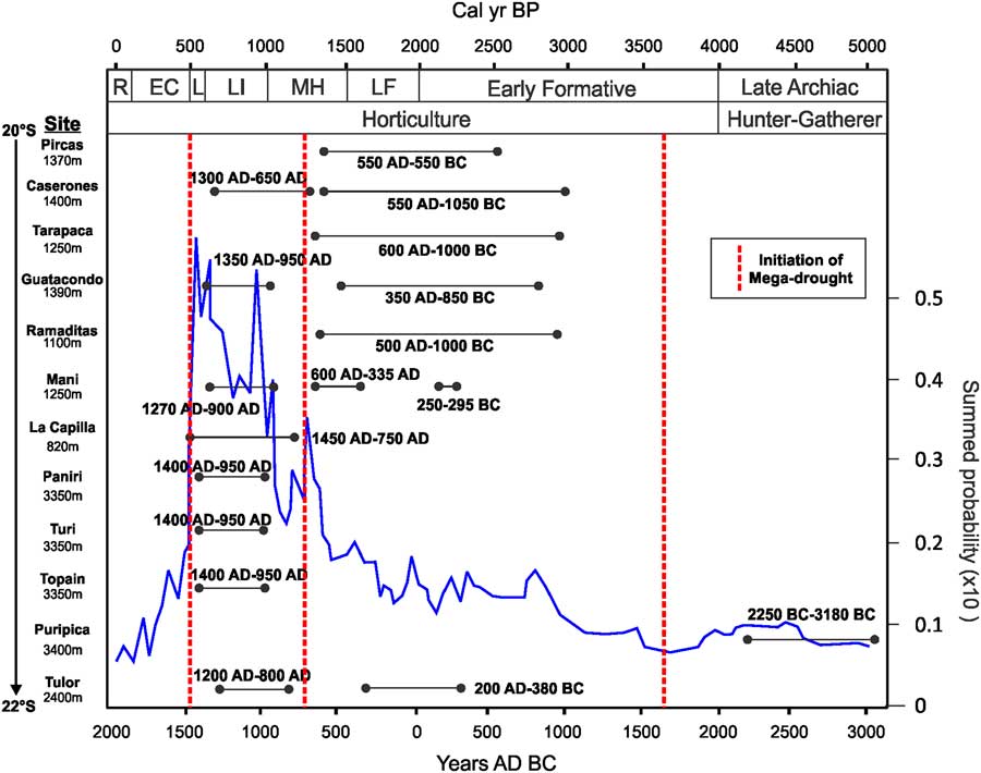
To assess the potential impact of megadroughts on societies that occupied the Atacama Desert, we explored the relationship between megadrought episodes and the intensity of human activities during the last 12,000 yr. In particular, we considered long-term paleodemographic trends for inland human populations based on the summed probability density obtained from 940 archeological 14C dates contained in the South Central Andes Radiocarbon database (Gayo et al., Reference Gayo, Latorre and Santoro2015). We complemented this perspective by considering other archaeological evidence for occupational dynamics derived from several Late Holocene archaeological sites (Formative, Late Intermediate, and Late periods) located in the Pampa del Tamarugal basin and the northern Atacama Desert and from the Calama and Salar de Atacama basins in the central Atacama Desert (Figs. 7d and 8). To determine how inland populations from the Atacama responded to regional-scale climatic events, we rely on the timing of Holocene megadroughts inferred from the in-stream wetlands.
(color online) Occupation of select archaeological sites in the northern Atacama Desert along with the summed probability densities for Late Holocene archaeological radiocarbon dates from the inland Atacama Desert (Gayo et al., Reference Gayo, Latorre and Santoro2015). Initiation of megadroughts inferred from in-stream wetlands. Abbreviations for cultural time periods: EC, Early Colonization; L, Late; LF, Late Formative; LI, Late Intermediate; MH, Middle Horizon; R, Republic Formation.

During the Early Holocene, the timing for incision of in-stream wetlands and sustained drought conditions is not very precise (Fig. 7a and b). This could be the result of slight differences in the initiation of severe droughts in the region, multiple droughts that occurred within several hundred years, different sensitivities of in-stream wetlands to drought conditions, or possible errors in age control. Although the first megadrought event (~9.8 ka) observed in the in-stream wetland deposits of Río San Salvador does not fit perfectly with the other in-stream wetland records (~10.3 ka), in general the megadroughts coincide with a sharp regional-scale population crash between ~10.2 and 9.5 ka that followed a phase of sustained population growth after the initial colonization of the Atacama Desert (Gayo et al., Reference Gayo, Latorre and Santoro2015; Figure 7d). Between 12.8 and 9.8 ka, humans in the Atacama Desert intensively exploited extensive wetlands and riparian forests leaving a remarkable archaeological record that includes evidence of residential bases and hunting locations, as seen in Pampa del Tamarugal and the Calama basin (Latorre et al., Reference Latorre, Santoro, Ugalde, Gayo, Osorio, Salas-Egana, De Pol-Holz, Joly and Rech2013; Nunez et al., Reference Nunez, Cartajena and Grosjean2013; Núñez et al., Reference Núñez, Jackson, Santoro and Méndez2016; Santoro et al., Reference Santoro, Gayo, Capriles, de Porras, Maldonado, Standen, Latorre, Castro, Angelo, McRostie, Uribe, Valenzuela, Ugalde and Marquet2017). Shortly after 9.8 ka and up to ~6 ka (Fig. 7d), inland population levels decreased significantly during the so-called archaeological silence, a cultural period marked by a considerable decline in human occupations along the western Andean slope between 20°S and 25°S (Nuñez and Santoro, Reference Nuñez and Santoro1988; Nunez et al., Reference Nunez, Cartajena and Grosjean2013). In the hyperarid core of the Atacama (Pampa del Tamarugal basin), this event is expressed by the abandonment of late Pleistocene hunter-gatherers’ open camps (Latorre et al., Reference Latorre, Santoro, Ugalde, Gayo, Osorio, Salas-Egana, De Pol-Holz, Joly and Rech2013). The abandonment of these initial hunter-gatherer sites largely coincides with the end of CAPE 2. The ensuing megadrought likely led to the movement of hunter-gatherer societies from the central Atacama Desert to coastal and highland environments (Rademaker et al., Reference Rademaker, Hodgins, Moore, Zarrillo, Miller, Bromley, Leach, Reid, Yépez Álvarez and Sandweiss2014; Salazar et al., Reference Salazar, Figueroa, Andrade, Salinas, Olguín, Power, Rebolledo, Parra, Orellana and Urrea2015; Capriles et al., Reference Capriles, Lombardo, Daniela Osorio, Herrera, Maley, Goldstein, Domic, Glascock, Veit and Santoro2016; Castillo and Sepúlveda, Reference Castillo and Sepúlveda2017; Osorio et al., Reference Osorio, Capriles, Ugalde, Herrera, Sepúlveda, Gayó, Latorre, Jackson, De Pol Holz and Santoro2017; Standen et al., Reference Standen, Santoro, Arriaza and Coleman2017). For instance, while the inland of the Atacama Desert remained unoccupied, the Chinchorro complex and associated mummification practices thrived along the Pacific seashore in northern Chile (Marquet et al., Reference Marquet, Santoro, Latorre, Standen, Abades, Rivadeneira, Arriaza and Hochberg2012). Similarly, a paleodemographic reconstruction for coastal populations shows high demographic levels throughout much of the duration of the archaeological silence (Gayo et al., Reference Gayo, Latorre and Santoro2015; Santoro et al., Reference Santoro, Gayo, Capriles, de Porras, Maldonado, Standen, Latorre, Castro, Angelo, McRostie, Uribe, Valenzuela, Ugalde and Marquet2017).
With the onset of the Late Holocene, sedentary agricultural communities adopted complex hydrologic management strategies to farm the floodplains of perennial streams. After the adoption of agriculture, the population of inland communities increased rapidly, beginning ~4 ka and peaking between 1.0 and 0.6 ka (Figs. 7d and 8; Gayo et al., Reference Gayo, Latorre and Santoro2015). During the Formative period (3.5–1.5 ka), communities developed extensive farming systems by managing water from perennial streams to cultivate maize (Zea mays), potatoes (Solanum sp.), manioc (Manihot esculenta), sweet potatoes (Ipomoea batatas), and chili peppers (Capsicum sp.), as well as fruit trees like Algarrobo (Prosopis sp.), and managed herds of domesticated camelids and guinea pigs (Cavia porcellus) (Núñez, Reference Núñez1979; Castro, Reference Castro2004; Agüero, Reference Agüero2005; Núñez et al., Reference Núñez, Cartajena, Carrasco, de Souza and Grosjean2006; Uribe, Reference Uribe2009; Núñez and Santoro, Reference Núñez and Santoro2011; Maldonado and Uribe, Reference Maldonado and Uribe2015; Uribe et al., Reference Uribe, Agüero, Catalán, Herrera and Santana-Sagredo2015; McRostie et al., Reference McRostie, Gayo, Santoro, Pol-Holz and Latorre2017). All cultivated plants, including the Algarrobos, were introduced during the Formative period from other American ecosystems, which implies that inhabitants from the Atacama Desert were continuously experimenting to create productive and fertile oases in the floodplains (Núñez and Santoro, Reference Núñez and Santoro2011; González-Silvestre et al., Reference González-Silvestre, Maldonado, Núñez, Cartajena, Carrasco and de Souza2013; McRostie, Reference McRostie2014; Vidal et al., Reference Vidal, García and Méndez-Quirós2015). As a consequence, these communities developed sophisticated technologies for managing surface water including the construction of water dams and reservoirs, irrigation canals, and well-drained agricultural plots (Rivera, Reference Rivera2005; Gayo et al., Reference Gayo, Latorre, Santoro, Maldonado and De Pol-Holz2012b; Urbina et al., Reference Urbina, Adán and Pellegrino2012; Rozas, Reference Rozas2014). This economic system was successful for several hundred years because diet was complemented by shellfish and fish brought from the Pacific coast, which implied that these goods were transported ~70 to 80 km inland (Uribe et al., Reference Uribe, Agüero, Catalán, Herrera and Santana-Sagredo2015). Reliance on llama (Lama glama) caravans for facilitating interregional exchange between coastal, interior, and highland communities became increasingly important, and temporary camps are often found in association with in-stream wetlands and springs distributed along the desert (Gallardo et al., Reference Gallardo, Correa, Pimentel and Blanco2017). This suggests the ancient communities of the Atacama Desert were optimizing the use of all available hydrologic resources. In the Pampa del Tamarugal basin, complex and diverse communities developed in sites such as Pircas, Caserones, Tarapacá, Guatacondo, Ramaditas, Quebrada Mani, and La Capilla (Uribe, Reference Uribe2006a, Reference Uribeb, Reference Uribe2009; Urbina et al., Reference Urbina, Adán and Pellegrino2012; Uribe and Vidal, Reference Uribe and Vidal2012; Adán et al., Reference Adán, Urbina, Pellegrino and Agüero2013; Cabello and Gallardo, Reference Cabello and Gallardo2014). The sustainability of the agricultural system would have been affected by reduced stream discharge as sustained drought conditions ensued. Moreover, the incision of these rivers would have required significant investment by communities to reengineer irrigation networks. The megadroughts at 1.3 and 0.5 ka correlate with sharp declines in inland populations (Fig. 7d) and the abandonment of numerous archaeological sites (Fig. 8). The megadrought at ~3.5 ka does not correlate to a sharp decline in population, but initial site occupation of several archaeological sites occurred shortly after this megadrought at around 3.0 ka.
In cases where streams switched from perennial to ephemeral or intermittent, socioeconomic reliance on permanent and predictable sources of water within these floodplains became unsustainable. Megadroughts could have provoked populations in the floodplains of the Atacama Desert, such as in the villages of Ramaditas and Guatacondo, which were dependent on agricultural, silvicultural, and hunting and gathering resources, to migrate. For instance, the archaeological hiatus between ~1.3 and ~1.1 ka in Quebrada Maní suggests that negative hydrologic budgets resulted in reduced local bioproductivity and temporary abandonment (Fig. 8 Gayo et al., Reference Gayo, Latorre, Santoro, Maldonado and De Pol-Holz2012b). These extreme climatic events seem to be linked to population migrations to upstream areas, particularly to elevations between 3000 and 4000 m of the western Andean slope, where water resources were more abundant and predictable (Pimentel and Montt, Reference Pimentel and Montt2008; Santoro et al., Reference Santoro, Gayo, Capriles, de Porras, Maldonado, Standen, Latorre, Castro, Angelo, McRostie, Uribe, Valenzuela, Ugalde and Marquet2017).
The shift in archaeological occupation from the Pampa del Tamarugal toward the highlands during the Late Intermediate period was possibly triggered either by the depletion in water and faunal/vegetation resources during the Little Ice Age (Latorre et al., Reference Latorre, Betancourt, Rylander and Quade2002; Latorre et al., Reference Latorre, Betancourt and Arroyo2006; Gayo et al., Reference Gayo, Latorre, Santoro, Maldonado and De Pol-Holz2012b; Maldonado and Uribe, Reference Maldonado and Uribe2015; Mujica et al., Reference Mujica, Latorre, Maldonado, González-Silvestre, Pinto, De Pol-Holz and Santoro2015) or sociopolitical turmoil (Uribe, Reference Uribe2006a; Uribe et al., Reference Uribe, Sanhueza and Bahamondes2007; Zori and Brant, Reference Zori and Brant2012). As water availability fluctuated throughout the subsequent centuries, human communities responded by decreasing the intensity of their presence in the Pampa del Tamarugal, often moving upstream into the canyons that occasionally discharged into the western basin (Santoro et al., Reference Santoro, Gayo, Capriles, de Porras, Maldonado, Standen, Latorre, Castro, Angelo, McRostie, Uribe, Valenzuela, Ugalde and Marquet2017). In the highlands, larger and more costly hydrologic and farming intensification infrastructure and village fortifications transformed the landscape of the western slope of the Andes. Most of this infrastructure is still visible today as it has continued to be used and managed by local indigenous Aymara communities that have persisted over time (Hidalgo Lehuedé, Reference Hidalgo Lehuedé2014). Correspondingly, the mostly abandoned Pampa del Tamarugal became an internodal territory occasionally occupied by opportunistic farmers following episodic flood events that inundated agricultural plots making them temporarily productive (Briones et al., Reference Briones, Núñez and Standen2005; Castro et al., Reference Castro, Berenguer, Gallardo, Llagostera and Salazar2016). This strategy was still practiced until a few decades ago in correspondence with a reduction in the frequency of stream events that flood the Pampa del Tamarugal (Núñez, Reference Núñez1979).
CONCLUSIONS
The term “climate change” is often used as a catch all phrase that includes not just the timing of wet and dry phases (i.e., the typical “pluvials”), but also the magnitude of change, the variation or departure from the mean, and the direction of change. Climate variability is especially important when making explicit hypotheses regarding the corresponding cultural response, such as adaptation, resilience, or collapse. Increased variance or deviation from mean conditions can have a greater impact on large agricultural societies that rely on precipitation availability and predictability than on smaller groups of mobile hunter-gatherers who can potentially move to more suitable environs.
Sustained and severe droughts have been shown to have had a large impact on human societies in the past and are a key concern regarding current and future climate change. Although several paleoclimatic proxies are robust recorders of long-term drought (e.g., tree rings, speleothems, and lacustrine records), these proxies are not common in either arid or hyperarid environments. As the sustainability of complex human societies in arid lands is often precarious because of the limited availability of water, these locations have the greatest need for the construction of long-term records of megadroughts and an understanding of the climatic conditions conducive to their occurrence. As exemplified by our case study, we show that streams with in-stream wetlands, common in many arid and hyperarid environments, may be important for documenting past megadroughts and potentially for forecasting future climate variability and the likelihood of severe and sustained droughts. Moreover, incision of perennial stream systems during droughts will have severe consequences to societies that have significant infrastructure (e.g., irrigation, sewage, municipal water, etc.) along these stream systems.
The in-stream wetland record developed here indicates that the Río San Salvador supported dense wetlands during several intervals in the Holocene, which were then incised by dry periods at ~9.8, ~3.5, ~1.3, and ~0.5 ka. Comparison with other in-stream wetland sequences across the region indicates a similar response with incision at times of megadroughts. A comparison with the record of Holocene ENSO variability in the tropical east Pacific indicates that these megadroughts could have been triggered by increased ENSO variability, especially during the Late Holocene at ~3.5 and ~1.3 ka.
A comparison between the timing of megadroughts in the Atacama Desert and changes in prehistoric societies (i.e., paleodemographic trends, dynamics and patterns in site occupation, and changes in cultural patterns) suggests that the periods of severe drought documented here were not harmless. On the contrary, they seem to have had profound impacts on past cultures. This is especially true for the Late Holocene, when population densities were higher and sedentary agricultural societies were more dependent on available and predictable freshwater for farming subsistence. Moreover, the abandonment of agricultural fields, irrigation canals, and other technological investments occurred as these systems either could not function or if the investment in labor required to reengineer these systems was too great once rivers incised the lowlands. These results imply a greater sensitivity of modern societies to drought than past societies, although this can be offset to some degree by greater infrastructure investment and technological development in climate change adaptation and mitigation strategies.
Future work on in-stream wetlands in the Atacama Desert should be able to refine the timing of megadroughts through targeted 14C dating of plant macrofossils from hydrophytic vegetation, as bulk organic matter and plant macrofossils derived from secondary phreatophytic vegetation will decrease the resolution of these records. Future archaeological work is also needed to target localities where occupation persisted during extreme droughts to understand how past societies adapted to extreme climatic conditions.
ACKNOWLEDGMENTS
The well-preserved outcrops of in-stream wetland deposits analyzed here were first identified by Andy Tomlinson during geologic mapping of the Calama basin and were then shown to JAR in 2003. We thank Karen Gotter and Jared Gooley for assistance in the field. This research was funded in part by a graduate student research grant from the Geologic Society of America to CDT and CONICYT PCI project PII20150081 (JAR, CL, JMC, CMS), CONICYT project PIA Anillo SOC1405 (EMG, CL, JMC, CMS), BASAL PF-23 (CL), FONDAP 15110009 (to CR2), CAPES FB-0002-2014, FONDECYT projects #1160744 (CMS, EMG, CL) and #11150210 (EMG). We thank Kathleen Springer and an anonymous reviewer for edits and comments that improved this manuscript.
SUPPLEMENTARY MATERIAL
To view supplementary material for this article, please visit https://doi.org/10.1017/qua.2018.122