

A previously overlooked association between Fernão vaz Dourado's historic navigational chart from 1571 and the presence of small, Yoruba-speaking colonies near the Niger River in Delta State of modern Nigeria provide the inspiration for this article.Footnote 1 Was there a connection between the ‘R∴ de iacomi (Lucumí River)’ on Dourado's sixteenth-century map and the modern ‘Olukumi’ villages? Could it be that these apparently unrelated designations indicated some common background that helps to unravel the conceptualization of a shared identity with enslaved people called ‘Lucumí’ taken to the Americas in the sixteenth century? The origins and meaning of ‘Lucumí’, which is fundamental to understanding the evolution of Yoruba identity, has been clouded in mystery and confusion. In consideration of the etymology of past terms used to identify people known as Yoruba today, this article reinterprets the discussion of the development of what some have referred to as the ‘Yoruba nation’.Footnote 2
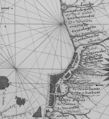
Close-up of ‘Costa da África e da Guiné até à ilha de São Tomé’ (1571). Map rotated 90° to face west and cropped from original size. Top to bottom: R∴ da volta (Volta River); a monta do gato (Cat Mountain); C∴ de s. palos (Cape St Paul); quatro montas (Four Mountains); C∴ do möte (Mote Coast); arvoredo (Grove); tera alagada (Swamp, or possibly Allada); as pomtuais (The Points); costa da rida (Coast of Allada); ollicere (?); jabu (Ijebu); dos canalos (Two channels, Lagos lagoon); aldeados (villages, i.e. Mahin); R∴ do doudo (dodo in Edo is ‘red scarlet cloth’); amatozado (?); benim (Benin); niare (Warri?); R∴ dos esprang (?); ffermozo (Formosa); R∴ de iacomi (Lucumí River); R∴ de säo bemto (São Bento River); R∴ de. s. barboza (St Barbara River); R∴ real (Real River); R∴ de. s. Dös (?); R∴ da cruz (Cross River); R∴ do comde (?); R∴ del rei (Rio del Rey); and R∴ ambos (Both). See Dourado, ‘Costa’, plate 266.

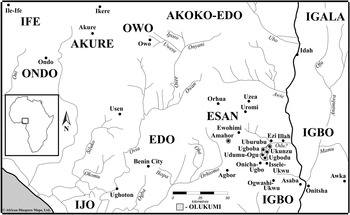
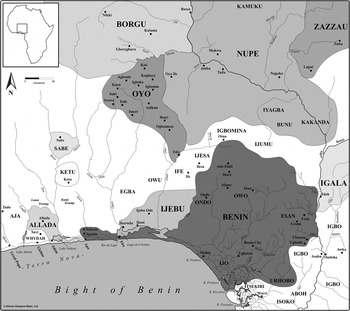
Olukumi Towns and their neighbours (2015). Source: H. B. Lovejoy, African Diaspora Maps (2014), available at: (http://www.africandiasporamaps.com).

This historical reassessment of the ethnonyms for Yoruba speakers, which includes ‘Lucumí’, ‘Terranova’, ‘Nagô’, ‘Aku’, and indeed ‘Yoruba’ itself, can help reveal patterns of identity formation. In the case of the various terms that referred to ‘Yoruba’, it is clear that ‘non-Yoruba’ peoples assigned these terms mostly as a label to describe ‘the other’, which ‘Yoruba’ did not necessarily use to describe themselves. In languages to the north of ‘Yorubaland’, such as Hausa, Songhay, and by extension Arabic, the term يرب (Yoruba) referred to a people Muslim traders could legitimately buy and sell since the sixteenth century, if not earlier.Footnote 3 The term ‘Nagô’, which was common in Brazil, as well as French and British colonies, first appears in des Marchais's account of Africa in 1725, among ‘nationalities’ of slaves sold at Ouidah. This term likely originated ‘as a self-appellation’ by a southwestern ‘Yoruba subgroup’ known as ‘Anago’, and adapted by Fon-speakers in Dahomey, anagonu, to refer to the ‘Yoruba’ in general.Footnote 4 The term ‘Aku’ relates to a ‘Yoruba’ salutation, eku, used among ‘Yoruba’ in Sierra Leone who had been liberated by British anti-slaving efforts after 1808.Footnote 5 ‘Lucumí’ and ‘Terranova’, however, have a more uncertain etymology, which requires further analysis, especially since these terms surface in sixteenth-century sources.
The ongoing usages of ‘Yoruba’ in West Africa, ‘Lucumí’ in Cuba, ‘Nagô’ in Brazil, and ‘Aku’ in Sierra Leone are evidence of self-ascription as ethnicity. These designations present major issues because ‘Yoruba’ and their descendants in diaspora consciously choose to refer to themselves using terms often appointed during enslavement. Moreover, ‘Yoruba’ is often applied retroactively in the historiography, even though European slave traders, slave owners in the Americas, and ‘Yoruba’ themselves didn't use the term before the nineteenth century. It was only until former slaves, Liberated Africans, missionaries, and their descendants returned to ‘Yorubaland’ and eventually adopted ‘Yoruba’ to identify themselves collectively. Beforehand, people in the Bight of Benin hinterland more often identified with their hometowns or political entities, such as Oyo, Owu, Ijebu, Ife, etc. Usages of towns and ‘Yoruba subgroups’ continue today as a means to differentiate within the broader ‘Yoruba’ identity, even though ‘Yoruba’ is generally and widely accepted in Africa and the Americas.
To understand the ethnogenesis of ‘Yoruba’ as a nation, this article focuses on the etymology of ‘Lucumí’ and ‘Terranova’ in West Africa and the early Atlantic World. We contend that the popularization of ‘Lucumí’ in the Americas has a close association with the inhabitants of a cluster of towns in modern-day Nigeria, who still identify themselves as ‘Olukumi’. Yoruba-speakers likely settled in the eastern part of the kingdom of Benin not later than the fifteenth century to specialize in chalk production. ‘Olukumi’ likely originated as an Edo-term at the height of Benin's imperial rule and referred to Benin's neighbours who spoke a foreign language, most likely ‘Yoruba’. Usages of ‘Olukumi’ within Benin are supported by the mythic and historic links between Benin and Ile-Ife, the cradle of Yoruba people. Variations of ‘Lucumí’ spread to the Americas via the Benin/Portuguese slave trade, which had deteriorated by c. 1550. At this time, ‘Terranova’ emerged to describe people taken from a ‘new’ region of commercial activity to the west of Benin control, which would later be known as the ‘Slave Coast’ or indeed the broadest usages of the eastern ‘Costa da Mina’. Our position is supported by the ubiquity of documented references of ‘Lucumí’ and ‘Terranova’ in the Spanish Americas between 1540 and 1640 (see Appendix).
PREVIOUS ETYMOLOGIES OF ‘OLUKUMI’ (OR ‘LUCUMÍ’) AND ‘TERRANOVA’
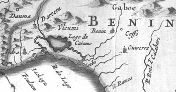
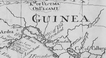
The relationship between ‘Olukumi’ settlements east of Benin and extant ‘Lucumí’ references has not been fully recognized. In 1914, Northcote Thomas observed that the Olukumi villages were ‘remarkable as being Yoruba islands’, but he did not equate this identity with usages of ‘Lucumí’ across the Atlantic.Footnote 6 By contrast, Fernando Ortiz suggested in 1916 that the kingdom of Oyo was ‘the origin of lucumí’ on the basis of the maps in Olfert Dapper (1668) and William Snelgrave (1734) to which he had access. These maps seem to indicate that the location of ‘Vlcumi’, or the kingdom of ‘ULCUMA OR ULCAMI’, could refer to Oyo, and by extension, ‘Yoruba’.Footnote 7
Close-up of Dapper's ‘Nigritarum regio’ (1668). Source: Map from J. Blaeu, ‘Nigritarum regio’ (1644), see O. Dapper, Naukeurige Beschrijvinge der Afrikaensche Gewesten… (Amsterdam, 1668), 322–3.

Close-up of Snelgrave's ‘A New Map of … the Coast of Guinea’ (1734). Source: Map from I. S. Mathen, ‘A new map of that part of Africa called the Coast of Guinea’ (1734), see W. Snelgrave, A New Account of some Parts of Guinea, and the Slave-Trade… (London, 1734), facing title page.

As British officials continued to file reports on Olukumi in the Asaba division of colonial Nigeria through the 1930s, no connection was made with Lucumí communities in Cuba.Footnote 8 William Bascom, who conducted fieldwork in West Africa and Cuba, observed that, ‘Lucumi [are what] the Yoruba of Nigeria are called in Cuba’, but he could not ‘find any place or people in Nigeria who are today known by a name like Lukumi.’ He concluded that the origin of the term ‘is still open to speculation’.Footnote 9 A breakthrough in identification occurred in 1953, when Ulli Beier observed that Olukumi communities were ‘conscious of their Yoruba origins and regard their language as a Yoruba dialect’. He argued that the term derives from a Yoruba greeting, olùkù mi, meaning ‘my friend’, and he made the link between Nigeria and Cuba.Footnote 10
By 1960, ‘Olukumi’ were reported in Esan towns, which had also been formerly part of Benin.Footnote 11 Nonetheless, the trans-Atlantic connections were virtually ignored. Peter Morton-Williams, for example, referred to the map in Dapper to argue that ‘Ulkami is beyond doubt Oyo’, while adding that it may be ‘a word of Gun [Badagry] origin … [and] may be derived from an Ijesha salutation.’Footnote 12 Later, and without reference to the ‘Olukumi’ villages, Bascom reached the same conclusion that ‘Lucumí’ referred to Oyo.Footnote 13 The misrepresentation concerning the origin of ‘Lucumí’ has since disseminated throughout the historiography.Footnote 14
Robin Law has since demonstrated that ‘Lucumí’ referred to a language, as well as a kingdom, country, or nation; and as such, a source of slaves, cloth, salt, corn, and gum. He has also questioned Beier's inference that the Olukumi towns east of Benin were related to the origin of ‘Lucumí’ in the Americas because this group ‘was not only small but remote from the main routes of supply for the Atlantic slave trade’. Like Beier, Law recognized that the continued use of ‘Olukumi’ in West Africa could indicate legacies of an identity formerly more widespread, and conceded that ‘Lucumí’ referred ‘[v]ery possibly … to a state or group of states inland from Ijebu, but specifically not Oyo as previously believed.’Footnote 15 The evidence is stronger than Law has previously accepted, particularly because of the overlooked ‘R∴ de iacomi’ on Dourado's 1571 map, which at the very least suggests the presence of ‘Lucumí’ on the coast to the east of Benin.
Europeans were major players in the making of African identities in the Atlantic World.Footnote 16 The Portuguese term, ‘Terranova’, emerged at the same time as ‘Lucumí’ and appears with more frequency in sixteenth- and early seventeenth-century documentation (see Appendix). Scholars have attempted to explain ‘Terranova’ in the West African context. However, there does not seem to be any consensus as to what was meant by ‘new land’, which references the ‘eastern guinea coast generally’.Footnote 17 Some have considered it was Porto Novo, which was founded after 1724.Footnote 18 Others thought it might indicate the southeastern coast of modern-day Nigeria.Footnote 19
Unlike ‘Lucumí’, which is still prevalent in Cuba today, ‘Terranova’ gradually stopped being used from the mid-to-late seventeenth century onward as the ‘Slave Coast’ and ‘Costa da Mina’ became more widespread geographic points of reference. This term generally referred to the ‘Gold Coast’ where the Portuguese purchased gold since 1471 and later built the fort São Jorge da Mina in 1482, and later renamed El Mina after the Dutch seized it in 1637. According to a document from 1699, however, the ‘Costa da Mina’ had a broad regional implication, which included ‘the Coast leeward [east] of Mina’, that is as far as the Volta River.Footnote 20 Likewise, the ‘Slave Coast’, which came to refer to the region between the Volta River and Lagos, was documented by 1688, but it was ‘clearly not a new coinage’ having been borrowed by the Dutch Slave-Kust and ‘ultimately from an earlier Portuguese original.’Footnote 21
CHALK IN THE KINGDOM OF BENIN
In order to explain the simultaneous emergence of ‘Lucumí’ and ‘Terranova’ as Atlantic designations, the economic basis for ‘Yoruba’ settlements in Benin requires analysis. Today, ‘Olukumi’ are collectively known as the Odiani clan in Aniocha Local Government Area of Delta State. According to tradition, the two oldest towns are Ukunzu (Ukwu-Nzu), and Ugbodu, with later offshoots Ubulubu (Uburubu), Udumu-Ogu (Idumuogo), and Ugboba.Footnote 22 There is an Olukumi quarter in the Esan town of Amahor. They are located on the west bank of the Niger, 75 kilometers east of Benin City and 50 kilometers from Idah to the south of the Niger/Benue confluence. These places are nestled among the western Igbo towns of Illah, Ezi, Issele-Ukwu, Onicha-Ugbo, Ogwashi-Ukwu and Esan towns of Ewohimi, Orhua, Uromi, and Uzea (see Fig. 2).Footnote 23
The Olukumi towns, small by today's standards, had economic, political, and ritual importance in the past due to chalk production and its widespread distribution. As food, chalk was a replacement for salt, and/or eaten like biscuits. As a medicine and soap, it was believed to alleviate morning sickness, stomach ailments, and bacterial infections. Cosmetically, it was used in body art, and house decorations. It was also used in chieftaincy installations, funerals, marriage ceremonies, birth and naming rites, hunting, initiations, and to invoke spirits and gods. As a major trade item and tributary payment, chalk was mined in different places, many of which are no longer remembered. However, chalk is plentiful in and around the Olukumi towns.Footnote 24
Very little research has been done to explain locations of chalk deposits or how far the chalk trade extended.Footnote 25 Initially, people as far back as Nok culture and/or Igbo from the Nri-Awka district likely settled in the region because of fertile farmlands, riverine trade and chalk, which is ‘plentiful in the area’.Footnote 26 According to land laws of the early twentieth century, anyone in the town at Ukunzu was at ‘liberty to procure the chalk’.Footnote 27 In fact, the Igbo etymology for ‘Ukunzu’ is ‘royal’ (ukwu) and ‘chalk’ (nzu). In Benin, chalk was significant because every Oba (king) sent pieces to provincial rulers and the refusal to accept this gift was considered an act of war.Footnote 28 The chalk trade was extensive. Orhua, which is an Esan village, means ‘chalk found on the riverside’, and may derive from orhue, which is an Edo word for chalk.Footnote 29
‘OLUKUMI’ OR YORUBA-SPEAKING SETTLEMENTS IN BENIN
The initial point in the development of ‘Olukumi’ identity has been dated to the rise of the Benin kingdom and specifically to the emergence of its monarchy. Thomas and Beier were told the ‘Yoruba’ ancestors of the Olukumi towns arrived with the first Benin king. Some traditions identify this king as Oranmiyan, a son or grandson of Oduduwa the mythical founder of Ile-Ife, who travelled to Benin to restore order and establish a new dynasty.Footnote 30 One of Oranmiyan's sons, Eweka I, became the first Oba and his ‘Yoruba’ associates, or ‘Olukumi’, probably helped to consolidate his power. Benin and Yoruba myths of origin are problematic. It is now popular in Benin to deny Oranmiyan's foreign identity and to describe him not as an Ife prince sent to Benin, but an exiled Benin prince who reclaimed his ancestors' throne.Footnote 31 What is not denied is that ‘Olukumi’ were Yoruba-speakers and they had an association with Benin's monarchy. If so, this might date Edo-Yoruba contact and the establishment of ‘Olukumi’ back to the Ogiso dynasty or pre-Oranmiyan period.
The inhabitants of the ‘Olukumi’ towns, especially at Ukunzu and Ugbodu, emphasize their ‘Yoruba’ heritage. This identity raises the questions: which ‘Yoruba subgroups’ settled at these towns and when did they arrive to the area near the Niger River? Traditions collected at different periods over the last one hundred years traced the homeland of the ‘Olukumi’ at Ukunzu and Ugbodu to the most eastern ‘Yorubaland’ and their arrival to their current sites in the early days of the Benin kingdom. The current Olihen (chief) of Ugbodu, Humphrey Ojeabu Ochei, claims people migrated to Ukunzu from Owo and Akure during indigenous Ogiso reign, which accords with Olukumi myths of origin that Thomas recorded indicating c. 1200 CE.Footnote 32
Irrespective of these traditions, ‘Olukumi’ identity emerged with the consolidation of early Benin monarchical authority, which relied on foreign support, including slaves who sometimes became bodyguards, soldiers, advisers, and even local chiefs. Similarly, the rise of ‘Yoruba’ monarchs and palace administrations depended upon the recruitment and support from foreigners, including people from Benin, to neutralize local enemies and consolidate power.Footnote 33 ‘Olukumi’, therefore, centred on the immigration of Yoruba-speakers into Benin territory and involved the ‘transculturation’ of sociocultural, political, and linguistic interactions in the Bight of Benin hinterland, including Edo, Igbo, Yoruba, Esan, Igala, among other groups.Footnote 34
The continued use of ‘Olukumi’ as an ethnic designation, which is not used elsewhere in ‘Yorubaland’, suggests a long history rooted in Benin expansion. According to tradition, Oba Ewuare attacked eastern ‘Yorubaland’ and western ‘Igboland’, in the third quarter of the fifteenth century. One of his successors, Ozolua, is said to have conquered Ikale and parts of Ijebu both in southern ‘Yorubaland’, but also pushed inland as far as the Niger River.Footnote 35 The relocation of eastern ‘Yoruba’ populations toward ‘Igboland’ likely intensified during the mid-to-late fifteenth century, suggesting ‘Olukumi’ was in use in West Africa before the Portuguese arrived at the coast.
Routes of migration varied, while enslavement was possibly a major factor. The Akure quarter in Ugbodu claimed their ancestors arrived ‘before the Owo section, but later than the Ukunzu’. They also mentioned ‘the Ajalama war as having been the ultimate cause of their transplantation’.Footnote 36 ‘Ajalama’ could either refer to ‘Agamo’, a forest in southern Ekiti known as a rendezvous for a Benin warrior, or the ancient occupants of the district called ‘Ijamo’.Footnote 37 The Owo section of Ugbodu claimed their ancestors arrived via Benin City as escorts of an Owo woman who married an Oba and gave birth to his first son. During the child's infancy, Benin nobles demanded the prince be executed, but the mother escaped with her supporters into Esan territory. According to traditions from Amahor, the Olukumi community claim their descendants were ‘refugees who [arrived from] Benin … about 1460’.Footnote 38 From Esan, the refugees likely went to Ugbodu, which means ‘Ugbo- (forest) and Odu (a river in [Esan])’, or possibly, ‘Ugbodumila’, literally ‘saved by the forest’.Footnote 39
Beier speculated that Ukunzu was ‘a military camp’ after a Benin Oba began subjugating Igbo villages. Ukunzu's alternative town name is Eko (Edo: military camp or farm) suggesting it was used as a garrison on Benin's eastern periphery. Yoruba and Benin traditions assert that Owo rulers travelled to Benin to receive chalk and pay tribute with slaves. Osogboye, an Owo prince from the sixteenth century, went to Benin to learn military techniques, and in return, people from Owo possibly became soldiers for Benin.Footnote 40 Due to warfare, Benin slaves might have also been sent to Ukunzu and Ugbodu to guard chalk deposits on the kingdom's eastern frontiers.
Olukumi from Ukunzu and Ugbodu were likely involved in the Uromi and Idah Wars in the early sixteenth century. To the northeast, Oba Ozolua attacked Uromi from his war camp in Esan territory at Uzea, where he died c. 1517. During the reign of his successor, Esigie, war spread toward Igala, which ‘can be taken provisionally as indicating the period in which Idah became politically independent of Benin’.Footnote 41 Both Benin and Igala traditions confirm Igala, allied with Idoma, almost reached Benin City, but were driven back across the Niger. According to Beier, ‘the Bini call the Atta of Idah the Otta and often refer to the town as Otta too’. It is therefore significant that the people of Owo quarter in Ugbodu claimed ‘they assisted [an unnamed] Oba of Benin to drive “Otta” to the River Niger’.Footnote 42
By c. 1550, Benin was one of the more powerful states in the Bight of Benin interior. Esigie's successor, Orhogbua, focused his efforts westward along the coast and established a military camp, also called Eko, on what later became Lagos Island. His actions ‘may have represented an effort to retain control of European trade, which was beginning to shift west with the rise of a powerful Aja state at Allada’.Footnote 43 At this time, Benin and Allada boundaries likely intersected. The towns of Ipokia, Itakete, and Eko (Lagos) all in southwestern Yorubaland claim ties with Benin, while Allada held control over Jakin and Apa.Footnote 44
States of the Bight of Benin Interior, c. 1580. Source: H. B. Lovejoy, African Diaspora Maps (2014), available at: (http://www.africandiasporamaps.com).

During Benin's period of westward expansion, Orhogbua may have neglected the kingdom's eastern periphery. In c. 1578, Orhogbua found the ‘towns on the western side of the River Niger in a state of rebellion [and] had neglected to pay their usual tributes’.Footnote 45 It is said Orhogbua sent the warrior, Agban, to reassert Benin authority and collect tributes, such as chalk. According to Olukumi tradition, an unnamed Oba ‘lived for some time in Ukunzu and he waged war from there’.Footnote 46 By c. 1580, Benin had reached its greatest territorial extent and controlled the region west of Eko to the Niger. Orhogbua's successor, Ehengbuda, continued campaigns, which ‘set the Benin and Oyo boundary at Otun’. Some traditions credited him with founding Ijebu and Akure dynasties.Footnote 47
Olukumi identity emerged during Benin's imperial period, which accords with Beier and Law's interpretations that Olukumi had a regional application. The coronation of the Obi of Ukunzu occurs at a shrine, called ‘Orogbuda (in Ukunzu) or Ohungbuda (in Ugbodu)’, which likely are a corruption of either kings' names, Orogbua or Ehengbuda. Into the twentieth century, the Oba of Benin sent messengers annually to make offerings at the shrine in Ukunzu. In a picture from 1953, there are rectangular bronze bells and chalk ‘exactly like those used in Benin [royal] shrines'.Footnote 48
While we do not contest that ‘Olukumi’ could have originated as a Yoruba phrase meaning ‘my friend’, we consider alternative etymologies from areas where the term first emerged. In Owo dialect, for example, ‘Olukumi’ means a ‘female lover’ or ‘concubine’. We also propose that ‘Olukumi’ was a pejorative Edo expression used to describe ‘the other’, that is foreigners, and likely slaves, who spoke an unintelligible language, most notably, but not limited to ‘Yoruba’. In Edo, oluku translates as ‘young one (of animals)’, as in oluku esi (young pigs), while mi is the demonstrative pronoun ‘that’, and/or mie is the verb ‘to have’.Footnote 49 Being a play on words, the dual meanings in different languages – ‘young animal’ or ‘foreigner’ in Edo and ‘my friend’ or ‘concubine’ in ‘Yoruba’ dialects – imply overtly ironic foundations upon which this Atlantic identity formed.
THE ROOTS OF ‘LUCUMÍ’ AND ‘TERRANOVA’ IN THE EARLY ATLANTIC WORLD
Shortly after the Portuguese began arriving to the Bight of Benin in the late fifteenth century, the slave trade with Benin began to develop. Ruy de Sequeira is credited with establishing contact with the kingdom of Benin in c. 1472 and with entering the ‘Lago de Curamo’, now known as the Lagos channel.Footnote 50 By 1486, Benin had become a source of slaves for the Portuguese. Between 1480 and 1525, estimates of the slave trade leaving the Bight of Benin suggest that not much more than 1,000 people were trafficked per year.Footnote 51 People were mostly taken to the Portuguese fort of São Jorge da Mina (Gold Coast), as well as the island of São Tomé, Portugal, and eventually the Americas.
Unfortunately, there is very little ethnographic data available from the earliest phases of the Portuguese/Benin slave trade. Before sailing up the ‘Rio de laguo’ (Lagos River) around the turn of the sixteenth century, Duarte Pacheco Pereira described the area as ‘composed entirely of beach’. From the lagoon, Pacheco Pereira reported on one officer, called ‘agusale’, and an inland city, ‘hoogeebuu’, which likely refer to the Awujale (king) of Ijebu-Ode, a Yoruba state located north of the Lagos lagoon.Footnote 52 It is important that Ijebu was never identified in conjunction with ‘Lucumí’.Footnote 53 This factor suggests that usages of ‘Olukumi’ not only occurred beyond Ijebu, as Law tentatively concluded, but also among non-Yoruba languages and ethnic groups.
After contact with Ijebu, Pacheco Pereira sailed up the Rio Formoso where he described ‘Huguatoo [Ughoton]’ and ‘Beny [Benin]’. Inland to the east of Benin City, he also referred to ‘a king called licósaguou … another big master that has the name hooguanee [and] a land of blacks called opuu [which was a source of] pepper & ivory & slaves’. Since Pereira likely received his information from Edo-speakers, it is reasonable to assume these terms were used in and around the Benin kingdom. Thus, the title ‘licósaguou’ might be a corruption of Ovbiosakon or Ivbiosakon, which refers to the practice of teeth filing among the people of Owan, Akoko-Edo, and Esan. It also relates to the name of a ward in Ukunzu, called ‘Idumokako’, which Beier described as ‘almost equivalent to a Benin military title’.Footnote 54 Similarly, the term ‘hooguanee’ could refer to an Edo/Edoid term for priest, deity, spirit, king, ancestor, or god (ohene, ohane, ohanese, onogie, or oghene). The term ‘opuu’ could be Nupe or the Edo term ‘Ebu’, which refers to the Igbo region near the ‘Olukumi’ towns.Footnote 55 At the height of its power, Benin commanded far-reaching networks in the region. It is highly possible that ‘Olukumi’ slaves went inland towards Ukunzu and Ugbodu, while others were sold to Portuguese merchants at the coast.
In the first third of the sixteenth century, the region between the Volta River and Lagos channel was ‘relatively neglected’ due to the lack of natural harbours, heavy surf, and a shallow sand bar running parallel to the beach.Footnote 56 By c. 1530, São Tomé merchants began to explore commercial opportunities at the Volta River, or the eastern periphery of the ‘Costa da Mina’. In this decade, there had still been no attempt to trade in the ‘new’ region between the Volta and Lagos. Trade between the Bight of Benin and the Americas was indirect and people boarding ships through Benin/Portuguese networks generally went to São Tomé first, along with people from West Central Africa, before crossing the ocean. Between 1525 and 1535, ten slave ships, with nearly two thousand individuals, arrived from São Tomé to Hispaniola.Footnote 57
In the early Atlantic World, the slave trade from the Bight of Benin was minor when compared to the rest of West Africa. Between 1540 and 1640, over 600,000 enslaved Africans reached the Americas and the majority of people boarded ships in West Central Africa (80.5 per cent), followed by the Upper Guinea Coast (17.2 per cent). The remainder arrived from the Lower Guinea Coast (2.3 per cent), which included the Gold Coast, the Bight of Benin, Bight of Biafra, and Gulf of Guinea islands. A majority of that total landed in the Spanish Americas (51.6 per cent), mostly at Cartagena de las Indias in New Granada, Vera Cruz in New Spain, and to a lesser extent, the Spanish Caribbean. Another contingent went to Brazil (48.3 per cent), primarily at Pernambuco and then Bahia. Otherwise, small groups landed in the British Caribbean, Europe, and mainland North America.Footnote 58
From 1540 until 1640, references to ‘Lucumí’ and ‘Terranova’ are ubiquitous and scattered in written sources from the Spanish Caribbean, New Granada, and New Spain, but for unknown reasons not Brazil (see Appendix). These terms likely referred to the same linguistic cluster, which mostly involved Yoruba speakers. By 1550, the Portuguese had imposed a temporary embargo on Benin probably over the rising cost of slaves. As a result, the slave trade began to shift west beyond Benin's influence. The earliest recorded instance of Portuguese trade with Allada and ‘the River of Popos’, that is, Great Popo to the west, was in the 1550s.Footnote 59 From the 1560s onward, ‘Ardra’ (among other variations for Allada) surface in the documentation, suggesting these people were ‘probably obtained directly from Allada rather than through intermediaries elsewhere on the coast’.Footnote 60
‘Lucumí’ was probably the term associated with slaves brought to the coast by Edo merchants and ‘Terranova’ with the lands of ‘new’ commercial activity not generally associated with Benin, likely between the Volta River and Lagos channel. ‘Terranova’, therefore, was different from ‘Lucumí’, ‘Ardra’, and even ‘Mina’, although there was probably much overlap, borrowing, and confusion of usages among European traders. If ‘Olukumi’ slaves came via Benin traders, they likely came from eastern ‘Yorubaland’, Esan, among others, while ‘Terranova’ could indicate people from western ‘Yoruba subgroups’, such as Anago, and perhaps Oyo, as well as other non-Yoruba groups, such as Popo, Whydah, Allada, and beyond.
The earliest known references to ‘Lucumí’ and ‘Terranova’ surface in Hernando Gorjón's plantation report from Hispaniola in 1547. Gorjón arrived to the Caribbean with Nicolás de Ovando y Cacéres in 1502, and by 1514, had a sugar plantation in Azua using Taíno slave labour.Footnote 61 Four years later, Charles V officially opened the trans-Atlantic slave trade ‘to take to the Indies … four thousand negro slaves’, and in 1528, the crown granted a license to bring four thousand more.Footnote 62 In 1537, Gorjón informed the crown that he housed ‘one hundred Negros and Negras’.Footnote 63 By 1540, Charles V issued Gorjón a personal license to buy 150 slaves to build ‘a university building and hospital’.Footnote 64 When Gorjón died in 1547, the crown seized his estate for auction and made an inventory. Among a list of 96 slaves, there were three ‘Lucumí’ and one ‘Terranova’, yet no reference to ‘Mina’ or ‘Allada’.Footnote 65
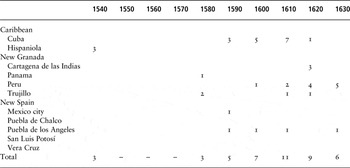
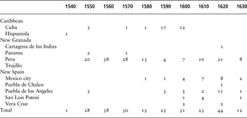
The two tables of selected references of ‘Lucumí’ and ‘Terranova’ are indicative of trading patterns at the Bight of Benin between 1540 and 1580 (see Appendix). There is more documentation related to ‘Terranova’ from a broad range of places, suggesting the trade from the region between the Volta River and Lagos channel became more prominent. There are also no known references to ‘Lucumí’ between 1550 and 1580, which possibly reflects the Portuguese embargo on Benin and supports our position that ‘Lucumí’ was an Edo term. The dramatic increase in ‘Terranova’ references after 1550 likely represents the ‘new’ commercial activities west of Benin control. After 1580, ‘Lucumí’ references resurface, perhaps indicating the Benin/Portuguese trade had resumed to some degree.
The references to Lucumí on Dourado's navigational chart from 1571 located the ‘R∴ de iacomi (Lucumí River)’, to the east of ‘benim [Benin]’ and ‘ffermozo (Cape Formosa)’ in the Niger Delta (see Fig. 1). This position suggests the ‘Lucumí River’ was one branch of the Niger River, and possibly a point of embarkation for Olukumi slaves. It is therefore significant that Ukunzu and Ugbodu are located just over 10 kilometers from the Niger River. While ‘iacomi’ is not spelled exactly like ‘Lucumí’, Law has identified at least 17 spelling variations from elsewhere at different periods.Footnote 66 If this interpretation is correct, this 1571 reference strengthens our argument that usages of Olukumi existed east of Benin by the late sixteenth century and that Portuguese merchants adopted the term at the coast. Navigational charts are full of historical inaccuracies, and an intensive survey of other old has not revealed a ‘Lucumí River’ elsewhere.
‘Lucumí’ and ‘Terranova’ do not appear in English, French, or Dutch sources in the early Atlantic World. The British had been involved in trade at the Bight of Benin since the mid-sixteenth century. However, they did not begin to take slaves across the Atlantic until later in the century, and when they did, they mostly supplied slaves to Spanish colonies. The French were engaged moderately in the region and mostly as interlopers. Their interest in bringing slaves to the Caribbean took off after their interest in St Domingue, Guadeloupe, and Martinique after the mid-seventeenth century. Likewise, the Dutch were not heavily engaged in the trans-Atlantic slave trade until after they seized the fort at El Mina in 1637. Otherwise, there does not seem to be any surviving documentation related to ‘Lucumí’ or ‘Terranova’ from Brazilian sources, which is very puzzling and certainly requires further investigation.Footnote 67
In his treatise on slavery from 1627, Alonso de Sandoval detailed African castas (castes), reynos (kingdoms), and naciones (nations), which he had observed in Lima (Peru) and Cartagena (Colombia), which he found ‘are so many, and so varied’. He included much ethnographic data on slaves arriving at Cartagena from São Tomé, and ultimately from ‘the mainland, kingdoms and ports’, including Benin and Allada.Footnote 68 Sandoval was among the first to describe subgroups of Lucumí, which increased in number over time.Footnote 69 He identified three different ‘castas’ of Lucumí – one without a subclassification, and two others labelled ‘Barbas’, likely Bariba of Borgu; and ‘Chabas’, possibly Sabe of Benin, or Chamba (now northern Ghana and Togo).Footnote 70 The ‘Lucumí’ Sandoval described arrived to Cartagena after Benin went into decline, and the trade at ‘Terranova’ had already begun.
According to Sandoval, ‘Lucumí’, among many other ethnonyms, had a geographic association with the Bight of Benin. He made reference to, ‘Popoos [Popo], Fulaos [Glehue], Ardas [Allada], or Ararers [Allada], that are all the same, Offoons [Offra], also casta Arda [Allada]; Lucumies [Lucumí] or Terranovos [New Land]; Barba [Bariba/Borgu], Temnes [Temne?], Binis [Benin], Mosiacos [Etsako?, Mokko?], Agares [Igala/Igara?], Gueres [Warri], Zarabas [Chamba?, Calabar?], [and] Iabus [Ijebu].’ What is particularly striking about this list is that Sandoval equated Lucumí with Terranova, having written ‘Lucumies or Terranovos’. More importantly, Sandoval described the palace servants in Benin as ‘lucumies estrangeiros’ (foreign Lucumí).Footnote 71
Sandoval also differentiated among ‘Lucumí’ slaves based on facial scarification and body decoration. Among the Lucumí who were not associated with a subgroup scarification included:
Three long and deep lines, one that clings to the entire length of the forehead just until the nose, and the two [other lines] on the temples, and on each side of the face another five [lines], the [first] three come to close off the mouth, and the other two in an arc from the temples down to the whole nose.Footnote 72
These markings did not necessarily refer to Yoruba speakers, and until a catalogue of scarification at different periods is undertaken, the relationship to ethnicity remains unclear. Sandoval identified ‘Lucumies Barbas’ because they pierced ‘the left nostril’ ‘without any other marking’.Footnote 73 Some Bariba groups scar the face, although this practice could have been introduced after 1627.Footnote 74
In comparison, the ‘Lucumies Chabas’
have [their] whole body painted, and in the middle of the forehead, they tend to have an Oval accompanied with two squares on the sides; and, on the edges of the mouth two lines go off to the ears, and on each side [there are] another six lines, three of which cross the neck, and close off behind the ears; and the other three [lines] cross the cheeks, and close off at the temples.Footnote 75
John Adams, the late eighteenth-century British slave trader, provided some corroboration of Sandoval's description. He described the ‘Chamba’ with marks consisting ‘of three strong lines drawn from the temple over each cheek to the chin, and taking the form of the longitudinal lines upon a globe’.Footnote 76 Sandoval's descriptions do not correspond to any facial marks in the nineteenth century, suggesting patterns and designs of scarification changed over time.Footnote 77
At the turn of the seventeenth century, Oyo began its expansion in the interior, while Allada dominated the coastal region of lagoons to the west of Lagos.Footnote 78 As Oyo and Dahomey became the two dominant states in the eighteenth century, they were the major suppliers of slaves in the region to the east of the ‘Costa da Mina’, that is ‘Slave Coast’, formerly known as ‘Terranova’. With the rise of Dahomey and Oyo in the early sixteenth century, the designations of ‘Lucumí’ and ‘Terranova’ gradually disappeared, being replaced with ‘Nagô’, except for Lucumí in Cuba.
CONCLUSION
An assessment of ethnonyms related to the early trans-Atlantic slave trade requires special methodological considerations because of the paucity of primary documentation. Some designations originated in West Africa, including ‘Lucumí’, ‘Nagô’, and ‘Yoruba’, while Europeans clearly invented others, such as ‘Terranova’, ‘Slave Coast’, and ‘Costa de Mina’. Failure to recognize how the meaning of ethnonyms and geographic reference points has changed over time has resulted in the telescoping of history and the misidentification of ethnolinguistic groups in relation to specific contexts. In 1547 on Hispaniola, for example, ‘Lucumí’ likely meant a slave from Benin, but more specifically from eastern ‘Yorubaland’, likely Owo or Ekiti. By 1627, Sandoval described different types of Lucumí, two of which likely had very little to do with ‘Yoruba’, but came from the deep interior beyond ‘Yorubaland’, such as ‘Barba’ and ‘Chamba’. Otherwise, Ortiz based his understanding of ‘Lucumí’ on Dapper's seventeenth-century map, which has led many to think that Lucumí referred to Oyo, whereas earlier it did not.
The terminologies used to identify Yoruba-speaking people have changed, sometimes surviving, as ‘Lucumí’ in Cuba and ‘Nagô’ in Brazil have done, and other times falling out of use, as in the case of ‘Terranova’. The use of ‘Olukumi’ lingers on between Benin and the Niger River as proof of how ‘non-Yoruba’ groups, specifically Edo, once described their immediate neighbours. As the European slave trade shifted west of Benin, Portuguese and Spanish merchants initially shifted ‘Lucumí’, or those people being purchased from Benin traders, to ‘Terranova’. In Portuguese, English, and French colonies, ‘Nagô’ came to replace ‘Lucumí’ and ‘Terranova’, except for Cuba where ‘Lucumí’ refers to an African-derived Cuban culture and language, as well as two distinct, yet intertwined religions known as Regla de Ocha and Regla de Ifá. ‘Lucumí’ religion and culture has since evolved into its own entity and has spread elsewhere in the Americas, especially after the Cuban Revolution of 1959.
This analysis of the origins of ‘Lucumí’ and ‘Terranova’ in the Atlantic context demonstrates that there does not appear to have been any ‘ancient name’ used by people now recognized as the cohesive group called ‘Yoruba’. The tendency is to think that people have always had a name for themselves stretching back hundreds of generations, but ethnolinguistic identities have many different layers, which change regionally and over time. The ethnonyms attributed to the diverse groups of peoples now known as ‘Yoruba’, with distinct dialects, and complex social organizations, took place in two ways: First from outsiders looking in, but also from an emergent understanding from within. Much like ‘Lucumí’ in Cuba, ‘Nagô’ in Brazil, and ‘Aku’ in Sierra Leone, ‘Yoruba’ in the Bight of Benin hinterland seem to have settled on a common identity, which has come to reflect a nation of transcontinental proportions.
APPENDIX
Appendix references by region
For Cuba, see P. Boyd-Bowman, ‘Negro slaves in early colonial Mexico’, The Americas, 26 (1969), 141n9. In the 1570s, there were many ‘Terranova’ because the single reference cited above describes ‘the tomb of the Negroes of Terranova’ located in Havana's cathedral; A. de la Fuente, C. G. del Pino, and B. Iglesias Delgado, Havana and the Atlantic in the Sixteenth Century (Chapel Hill, 2008), 122–4; A. de la Fuente, ‘Esclavos africanos en La Habana: zonas de procedencia y denominaciones étnicas, 1570–1699’, Revista Española de Antropología Americana, 20 (1990), 135–60; emails with A. de la Fuente, 7–10 Nov. 2014; and D. Wheat, ‘Sagrada Catedral de San Cristóbal de La Habana, libro de barajas: bautismos, 1590–1600’ (East Lansing, 2012), 1–56.
For Hispaniola, see AGI Patronato Real 173/1/8, 6r, 7r, and 7v, ‘Fundación de colegio general y hospital: Santo Domingo, 1540–1547’.
For Cartagena de las Indias, see A. Sandoval, Naturaleza, policia sagrada i profana, costumbres i ritos, disciplina i catechismo evangelico de todos Etiopes (Sevilla, 1627), 59 and 65v-66.
For Panama, see C. F. Jopling, Indios y negros en Panamá en los siglos XVI y XVII (Guatamala, 1994), 247, 364, and 373.
For Peru, see F. P. Bowser, The African Slave Trade in Colonial Peru, 1524–1650 (Stanford, 1974), 40–4; and J. Lockhart, Spanish Peru, 1532–1560: A Social History (Madison, OH, 1994 [orig. pub. 1968]), 196.
For Trujillo, see R. S. O'Toole, ‘Inventing difference: Africans, Indians, and the antecedents of ‘race’ in colonial Peru (1580s–1720s)’ (unpublished PhD thesis, University of North Carolina Chapel Hill, 2001), 368–9.
For Mexico City, see G. Aguirre Beltrán, La población negra de México, 1519–1810: estudio etno-histórico (Mexico, 1946), 133 and 301, fn. 34; research notes from M. C. Díaz Casas, Escuela Nacional de Antroplogía e Historia (2014), Archivo General de la Nación, México (AGNM), Indiferente Virreinal, Matrimonios, 4912/72 1588; 1966/1 1607; 1966/1 1607; 5727/95 1613; 4483/49 1625; 4838/2 1622; AGNM, Regio Patronato Indiano, Matrimonios 69, Vol. 85, Exp. 115, 1629; Vol. 136, Exp. 35, 1631; C. V. Masferrer León, ‘Familia, niñez e identidad social entre los esclavos de origine africano de la ciudad de México, en la primera mitad del siglo XVII’ (unpublished thesis, Escuela Nacional de Antropología e Historia, 2009), 364, 369, 374, and 404; C. A. Palmer, ‘From Africa to the Americas: ethnicity in the early black communities of the Americas’, Journal of World History, 6:2 (1995), 223–36; and E. M. E. Silva Hernandez, ‘La esclavitud negra en la Ciudad de Mexico durante el periodo 1555 a 1655 a través de los documentos notariales’ (unpublished thesis, Universidad Nacional Autónoma de México, 1998), 310 and 364.
For Puebla de Chalco, see research notes from M. C. Díaz Casas, AGNM, Instituciones Coloniales, Regio Patronato Indiano, Matrimonios 69, Vol. 85, Exp. 25, 1621.
For Puebla de los Angeles, see Boyd-Bowman, ‘Negro’, 141; P. M. Sierra, ‘María de Terranova’, 49–50, and 60, fn. 17; and email with P. M. Sierra, 4 Nov. 2014.
For San Luis Potosí, see R. A. Montoya, El Tráfico de Esclavos en San Luis Potosí en los siglos XVII y XVIII (San Luis Potosí, forthcoming); and email with R. A. Montoya, 20 Aug. 2014.
For Vera Cruz, see research notes from M. C. Díaz Casas, AGNM Instituciones Coloniales, Indiferente Virreinal 1966/1, 1607; Regio Patronato Indiano, Matrimonios 69, Vol. 88, Exp. 16, 1621; and GNM Instituciones Coloniales, Indiferente Virreinal, Exp. 114, 1629.
No known references currently identified in Spanish Florida, other Spanish Caribbean islands, Brazil, as well as British, French, and Dutch colonies. Sometimes cited references were grouped into larger periods that overlapped with decades or were left undated. If we could not contact the author, we sometimes made assumptions.
Select references of ‘Lucumí’ in the Spanish Americas by decade, c. 1540–1640.

Select references of ‘Terranova’ in the Spanish Americas by decade, c. 1540–1640.