


Contexts
In the summer of 1966, Granada Television broadcast a documentary exploring the social tensions of Moss Side as an immigrant enclave being transformed by slum clearance in Manchester. Titled Living on the Edge, the program emphasized the crime and deprivation of the area, including a police reenactment of a raid on one of the basement music clubs (shebeens) that were a focus for Caribbean migrant sociability. Yet while Living on the Edge constructed Moss Side as a marginalized ghetto to parallel those of Watts or Harlem, which had so recently erupted in race riots, what was most striking for the residents of Moss Side was that the majority of images used in the documentary were not of their own neighborhood (Guardian 1966; Observer 1967). The physical landscape that was depicted in Living on the Edge ranged across the wards of South Manchester from Trafford, Whalley Range, Longsight, and Hulme, revealing that as a marker for racial deprivation the borders of Moss Side stretched far beyond its administrative or physical boundaries.
British debates over ethnic segregation have been marked by a profound divergence between academic research and public/policy discourse. In the public arena, perceptions of increasing residential segregation since 2000 have developed alongside increasing Islamophobia (Garner Reference Garner2010: 159–74), which fuses terrorism and foreign politics with broader concerns around domestic social and cultural change. In contrast, debates over spatial segregation in the social sciences have played out in progressively more arcane contests over the most appropriate statistical means of measuring ethnic polarization. In this article we adopt a different approach, taking up Jane Bennett's challenge to address the intersection between the animate and inanimate in everyday life (Bennett Reference Bennett2010), by more closely enmeshing the material and human dynamics that are both clearly imperative to an understanding of the historical dynamics of ethnic settlement. This article uses areal interpolation to explore the shifting connections between migrant demography, housing tenure, and the built environment within an immigrant gateway area in Manchester. Current scholarship on ethnic geography in Britain has been based on quantitative and qualitative analysis of administrative units that are often assumed to be internally homogenous. However, geographic information systems (GIS) allow us to go beyond administrative geographies to identify the “meaningful social boundaries” (Reardon and O’Sullivan Reference Reardon and O’Sullivan2004: 123–24) that shaped the dynamics of residential segregation and mobility within these areas.
During the mid-twentieth century, scholarship on Britain's ethnic geography focused on the gateway areas of early immigrant settlement in cities such as Cardiff, Liverpool, East London, and Birmingham. Drawing on the Chicago School's conceptualization of a “zone of transition,” John Rex and Robert Moore analyzed how in Sparkbrook, Birmingham, immigrant residential strategies were powerfully shaped by localized housing markets, state policies, and social relationships (1967: 272–85). From the mid-1960s, extensive slum clearance programs in Britain's largest conurbations produced a wave of research exploring how many migrants sought to resist displacement from gateway areas (Ward Reference Ward1975) and the impact of state policies and racism in restricting their housing options (Karn and Phillips Reference Karn, Phillips, Blackstone, Parekh and Sanders1998). Urban clearances not only radically transformed the physical landscape of migrant gateway areas, but also they produced a tenure revolution in opening up immigrant access to public housing. While studies at the time focused on this triangular relationship between ethnic demography, housing tenure, and the built environment (Ward Reference Ward1971), there has been little subsequent research on the long-term impact of urban renewal on ethnic settlement in Britain.
The statistical construction and deconstruction of the British “ghetto” has been the subject of intensifying academic and policy examination over the past two decades, which has yielded a substantial body of quantitative (Finney and Simpson Reference Finney and Simpson2009a, Reference Finney and Simpson2009b; Johnson et al. Reference Johnson, Poulsen and Forrest2005; Mateos et al. Reference Mateos, Singleton and Longley2009; Peach Reference Peach2009; Simpson Reference Simpson2007) and qualitative (Phillips Reference Phillips2007; Phillips et al. Reference Phillips, Davis and Ratcliffe2007; Slater and Anderson Reference Slater and Anderson2012) research, however, approaches to the study of segregation that seek to marry these perspectives remain elusive. For many cultural geographers, statistical analysis of migrant residence are too blunt an instrument to understand the vagaries of the housing market (Bolt et al. Reference Bolt, Özüekren and Phillips2010: 170; Phillips et al. Reference Phillips, Davis and Ratcliffe2007: 218) and thus scholarship has largely followed parallel modus operandi.Footnote 1 The focus of contemporary debate in Britain on ethnic self-segregation has tended to narrow the range of factors that are considered as shaping residential choice, often excluding the constraints of housing markets and intervention by the local state that were seen as so significant in earlier research (Peach and Byron Reference Peach and Byron1993, Reference Peach and Byron1994; Peach and Shah Reference Peach and Shah1980).
At the qualitative level, the work of the urban sociologist Loïc Wacquant (Reference Wacquant2008) has been a powerful influence for a new wave of scholarship in Britain focusing on the racialization of inner city areas and the impact of “territorial stigmatization” by the state and media (Slater and Anderson Reference Slater and Anderson2012). Wacquant has drawn parallels between Manchester's Moss Side and various other urban “neighbourhoods of relegation” in which the “spatial stigma” experienced by the residents of such areas transcends ethnic boundaries to encompass broader socioeconomic spatial divisions (2007: 116; 2008: 241). The racialized stigma attached to Moss Side has been an enduring focus for research (Fraser Reference Fraser1996), as it has persisted despite the complete physical transformation of inner-city Manchester through successive iterations of comprehensive redevelopment in the postwar era. Yet the impact of these radical changes through both space and time have been largely overlooked in discussions on ethnic and socioeconomic polarization that have presented such areas in monochrome and static terms.
Methods and Challenges in the Creation of “Meaningful Boundaries”
What so clearly links the divergent qualitative and quantitative studies of segregation in the British context is the materiality of our towns and cities. GIS offers a new way of engaging with both sides of this scholarship through the spatial analysis of microscale survey data, archival evidence and oral testimony. The urban clearances in Moss Side during the 1960s and 1970s produced a dense body of housing surveys by planners, academics, and community groups that emphasized the internal heterogeneity of the area's housing stock and the diversity of population movements in the area. Connecting these surveys together is not only of empirical value but also methodologically instrumental, for, as Savage (Reference Savage2007) has argued, the reuse of existing academic data sets can shed new light on the contemporary fears and priorities that shaped the original investigative methodologies. Using areal interpolation to disaggregate a migrant gateway area such as Moss Side enables us to explore how tenure and housing type impacted on immigrant settlement and how this was changing over time due to migrant life courses and urban policies.
Areal interpolation has been one of key techniques in historical GIS to establish a consistent spatial framework through which to analyze demographic change over time (Gregory Reference Gregory2000; Gregory and Ell Reference Gregory and Ell2006). It has been far less commonly used by historians to construct microhistories of how populations are positioned within the built environment. This article uses areal interpolation both to analyze change over time and to explore the relationship between census geographies and the physical areas affected by the urban clearances. Reallocating census data at enumeration district (ED) level to specific clearance areas in Moss Side emphasizes the diversity of population profiles and housing dynamics that existed within the ward. Disaggregating from administrative boundaries to the material landscape through areal interpolation reveals how geographies of ethnic settlement were powerfully impacted by the built environment and particularly how these were remade through successive waves of urban reconfiguration in inner-city South Manchester since the 1960s. Areal interpolation therefore enables us to move beyond the constraints of census units (such as the assumption of ward homogeneity) to assess the microgeographies and other forms of boundaries that imposed themselves on the everyday lives of its residents.
Quantitative studies of ethnic geography in Britain have overwhelmingly focused on census administrative boundaries, and these remain central in efforts to recast the debate over ethnic segregation in terms of area typologies based on population composition (Poulsen and Johnston Reference Poulsen, Johnston, Dwyer and Bressey2008). While such approaches provide valuable comparative analysis of differences between ethnic groups, they have been much less robust in measuring change across time due to shifts in ethnic classifications and in the recording of base populations in the UK census (Peach Reference Peach1996; Sabater and Simpson Reference Sabater and Simpson2009; Simpson Reference Simpson2007). Furthermore, the lack of consistent census boundaries has posed the question as to whether measured change is actually substantive or whether it is simply the product of alterations to the spatial units under inspection (Anderson and Shuttleworth Reference Anderson and Shuttleworth1998: 191). This raises the spectre of the modifiable areal unit problem, in which phenomenon can appear more or less pronounced at the same spatial scale depending on how that space is carved up (Openshaw Reference Openshaw1984). At a philosophical level, even where methods exist to reconcile spatial unit changes, we need to reflect on the meaning and implications of the areal definitions of “self” and “other” that the data divisions impose upon us (Mol and Law Reference Mol and Law2005: 637).
In Manchester, the area identified as Moss Side has been the subject of radical change over successive censuses in the postwar period. Administrative boundaries must be temporally flexible if they are to retain meaning and reflect shifting populations so that the instability in the formal spatial frameworks for inner-city South Manchester were indicative of the seismic material and demographic changes to which the area was subjected in the postwar period. At the heart of this was a series of major programs of slum clearance and comprehensive redevelopment that transformed this part of the city in physical and social terms. Figure 1 highlights the difficulties in trying to trace the demographic impacts of these changes by overlaying the major clearance areas onto the underlying administrative geographies for three successive censuses between 1971 and 1991. This triptych shows how profoundly the ward and ED boundaries altered across the course of those three censuses. So dramatic were the changes that only 57 percent of the area covered by the Moss Side east and west wards in 1971 was included within the 1991 Moss Side ward.
Development areas of Moss Side and Hulme with ED and ward boundaries in (a) 1971, (b) 1981, and (c) 1991.

Areal interpolation enables us to reconcile these transformations of administrative units in order to facilitate time-series analysis of population change. To standardize divergent boundary data sets over time we calculated the difference between two areal units and then reallocated the data relative to the areal proportions of each unit (Gregory Reference Gregory2000; Gregory and Ell Reference Gregory and Ell2006). This technique within GIS is a simple and effective means of redistricting data onto consistent spatial units by calculating the degree of overlap between “source” and “target” geographies. The data for the source layer are then redistributed according to the spatial proportion of the target geography (Gregory Reference Gregory2008: 775).Footnote 2 The formula for basic areal interpolation can be expressed thus,
 $$\begin{equation*}
\hat y^t = \sum\limits_s {\left( {\frac{{A_{st} }}{{A_s }}\times y_s } \right)}
\end{equation*}$$
where ŷ is the new estimated population of the target zone and ys is the population of the source unit, while As is the area of the source unit and Ast is the area of the zone of intersection between the target and source units (Gregory and Ell Reference Gregory and Ell2007: 138–39). The data for each census was interpolated onto the 1981 ward boundaries by calculating the zones of intersection between the target (1981) wards and constituent EDs for each year.Footnote 3
Areal interpolation is effective in this study because the source units (EDs) are small relative to the target units (1981 wards). Simpson (Reference Simpson2002: 69–82) has provided a useful measure of the effectiveness of any attempt at spatial interpolation that he terms the “degree of fit.” The formula for this technique is,
 $$\begin{equation*}
100\;*\frac{{\sum {_s (\max \;[(w_{st} )} )]}}{{\sum {_s (1)} }}
\end{equation*}$$
where s is a source spatial unit, in our case EDs; t is a target geography, which in this case is the 1981 wards; and w is a weight taking a value between 0 and 1. In this instance the weight is the proportion of overlap between the source and target geographies. Using this technique returns a degree of fit between the 1971 ED boundaries and the 1981 wards of 88.8 percent.Footnote 4 The same analysis on the 1991 ED boundaries returns a degree of fit of 98.2, meaning that we can be confident of a very high degree of accuracy in the interpolating of data from the source to target geographies.
Areal interpolation is a useful technique, but as the references already cited indicate, it is one that has already been extensively used to correct for boundary inconsistencies in the analysis of localized population change. However, in this article we take the methodology a step further by using it to deconstruct statistically, spaces that tended to be racialized as homogenous in the public imagination. British discourses on inequality have tended to focus solely on problematizing the working classes and the spaces they inhabit while neglecting those at the top of the social structure (Burrows Reference Burrows2013a, Reference Burrows2013b; Cunningham with Savage Reference Cunningham and Savage2015). Writing about northern Britain, Owen Jones (Reference Jones2011) has emphasized the broadly negative public perceptions of large-scale social housing projects in the United Kingdom. There is therefore a strong rationale for the approach we adopt here in applying areal interpolation in not simply trying to rectify arbitrary administrative boundaries but also in using the technology to make sense of the implications of radical change in the built environment, and in so doing, staying true to our core objective of addressing the relationship between material, cultural, and social geographies through a twin qualitative-quantitative methodology. Reallocating census data at ED level to specific clearance areas in Moss Side reveals the different population and housing dynamics that existed within the ward. Disaggregating from administrative boundaries to the material landscape through areal interpolation reveals how geographies of ethnic settlement were powerfully shaped by the built environment and particularly how these were remade through successive waves of urban reconfiguration in inner-city South Manchester since the 1960s. We argue that areal interpolation therefore enables us to move beyond the constraints of census units to assess the microgeographies and other forms of boundaries that imposed themselves on the everyday lives of its residents.
Urban Planning and the Microgeographies of Immigrant Settlement in Postwar Manchester
In 1945, Manchester's planners argued that 60 percent of the city's housing stock was in need of redevelopment, of which more than 60,000 homes “were unfit for human habitation” (Nicholas Reference Nicholas1945: 3). Particularly problematic was the working-class housing built in the mid-nineteenth century that flowed south of the city center from Hulme and Chorlton-upon-Medlock into the neighboring wards of east and west Moss Side. The majority of residential accommodation in Moss Side had been built in the 1870s and 1880s, which planners noted “although showing a marked improvement on the standards of the earlier period, are still laid out to a cramped and dreary grid-iron pattern in monotonous streets of tunnel-back dwellings” (ibid.: 27). Manchester's falling fertility rates and high outflows due to internal migration led local officials to expect that the city's population would fall from more than 702,000 in 1951 to 546,650 by 1981. Reimaging Moss Side as low-density suburbia with only a third of its prewar population, planners also envisioned converting Princess Road into a six-lane-wide highway that would act as the main southern traffic artery from the city (ibid.: 8–15). The ambition of the 1945 plan to totally transform the inner city was immediately constrained by postwar austerity that severely limited the resources of local authorities for rehousing programs (Mason Reference Mason1977: 15–16; Parkinson-Bailey Reference Parkinson-Bailey2000: 161–80). This tension between the aspiration for extensive urban clearances and the restricted options for rehousing inner-city populations would intensify in the following decades as Moss Side became the gateway for new immigrants arriving in postwar Manchester.
During the 1950s, the “colored population” of Manchester rose from an estimated several thousand to more than 10,000 fueled by immigration from the British Caribbean, South Asia, and West Africa. Within Manchester, the decade after 1951 was marked by the tenfold increase in the city's Caribbean population as it became its leading nonwhite ethnic group (table 1). By 1966, Manchester had 14,000 immigrants from what had become defined as the “New Commonwealth,” giving it the largest black population outside London and Birmingham. Manchester was also the focus for a significant internal migration by immigrants after they had arrived in Britain as more than a thousand black workers moved to the city from their initial settlement points in Liverpool and the Midlands due to both employment opportunities and access to housing (Ward Reference Ward1975: 309–10). Discrimination in Manchester's private housing market and shortages of public accommodation meant that most of these newcomers were concentrated in private rental housing because of the two-year residence requirements for council housing.
Population of Manchester by place of birth, 1951–2011

Source: 1951–2011 Census of Population.
At the junction between the dense back-to-back housing of the inner city and the large semidetached residences of the suburbs, Moss Side contained a variegated landscape marked by differences in housing stock and tenure (figure 2). Figure 2, which is based on an immediate postwar appraisal of housing quality conducted by Manchester City Council (MCC), also shows the remarkably dense commercial infrastructure of local shops and pubs that existed in these neighborhoods prior to clearance. Initial settlement by black immigrants began in the 1930s and focused on the Denmark Road area of eastern Moss Side where large three-story Victorian terrace houses had been subdivided into rooms for private rental (Kinder Reference Kinder1969: 7). In the mid-1950s, these apartments mixed Caribbean, African, Indian, Chinese, and Irish immigrants leading the Manchester Guardian to describe Denmark Road as “the heart of Moss Side,” which was “an area which is an inter-racial as any in the world” (1957: 14). In a rather less positive depiction of the area in the same year, the Manchester Evening News described it as an “unsavoury quarter” with a “floating population. They have no roots with nothing to give them standing in the community” (1957: 4). By contrast, the south of Moss Side was seen in the same article as more respectable, with a more stable population. This gateway area of initial immigrant settlement ran north from Moss Lane East and was bounded by the University of Manchester and Whitworth Park to the north and west. Many migrants circulated through a series of rented rooms in eastern Moss Side before seeking more stable accommodation in the two-storied and three-storied terrace houses in western Moss Side (Roots Oral History Project 1983).
Age of residential property in Hulme and Moss Side, 1945.

By the late 1950s, as immigrant families from the Caribbean were reunited or formed, the focus of their settlement shifted significantly to western Moss Side. Princess Road was seen as marking a boundary between the temporary rooms of the gateway area around Denmark Road and the higher status accommodation available in western Moss Side (Kinder Reference Kinder1969). This shift in settlement meant that “by the mid-1960s single family occupation was again becoming the norm in many parts of Moss Side” (Ward Reference Ward, Miles and Phizacklea1979: 206). The concentrated pursuit of property ownership or rentals by Caribbean immigrants in this secondary area of settlement was also powerfully shaped by the extensive discrimination they faced in seeking homeownership elsewhere in Manchester (Ward Reference Ward1975: 318–19). By 1961, the greatest concentration of Caribbean immigrants in Moss Side was to be found between Moss Lane West and Raby Street where they were 32.5 percent of the ED population whereas in the initial gateway area on Moss Lane East they represented only 21.5 percent of the ED population (Kinder Reference Kinder1969: 13). It was the availability of housing that acted as a “pull” factor in fueling secondary movement of Caribbean migrants to Manchester up from the midlands cities of Nottingham and Birmingham, where access to home ownership or larger rental properties was much more difficult elsewhere (Lawrence Reference Lawrence1974: 87; Rex and Moore Reference Rex and Moore1967).
The 1961 census recorded 2,340 Caribbean-born residents in Moss Side, representing more than 60 percent of the total Caribbean population for Manchester (Kinder Reference Kinder1969: 12). Strikingly, the southeast of Moss Side was largely unaffected either by the initial growth of Caribbean immigrant settlement in eastern Moss Side or their westward expansion. This was partly due to differences in housing stock as the southeast of the district was dominated by smaller “terra-cotta” style terrace houses that were unsuitable for being broken up into private rental accommodation and was also due to its concentration of council housing that excluded immigrants based on residence requirements. In 1961 across the 13 EDs in eastern Moss Side south of Great Western Street, the Caribbean-born population was below 5 percent in all but one, and below 2 percent in eight of these EDs (ibid.: 13). This relationship between the geography of immigrant settlement and housing stock in Moss Side was visualized through a series of maps produced by the MCC in 1968 (figure 3). Our data for 1968 combines the MCC survey material with that undertaken in the same year as part of a doctoral thesis by a Manchester University researcher (Ward Reference Ward1975). The data for 1971 and 1981 have been derived from the census in those years.
Immigrant population and housing tenure in Moss Side and Rusholme, 1968, 1971, and 1981.

The gateway area of eastern Moss Side around Denmark Road was marked by the predominance of rental properties and higher immigrant populations; in the area of secondary settlement in western Moss Side there was a more mixed range of accommodation available but with clearly higher levels of owner occupation; and in southeastern Moss Side there was a relatively small immigrant population, again characterized by higher levels of private home ownership. To the north of Moss Side, Hulme was one of the areas most affected by the physical destruction of the clearances during the 1960s resulting in commentators describing it in terms of a depopulated wasteland, as the “community had been demolished with the housing” (Gaskell and Benewick Reference Gaskell and Benewick1987: 225).
Just three years later however, the situation had changed remarkably. Hulme was now completely dominated by social housing as tenants began to take up occupancy on the massive new council estate. In Moss Side though, little had changed although the role of the eastern areas as a migrant gateway had intensified, with newcomers making up a majority of the population in a number of EDs around Denmark and Oxford roads. These areas continued to be defined by various forms of private rental accommodation, while the highest levels of owner occupation could still be found in the terraces south of Great Western Street. In addition, the University of Manchester was also playing a part in the redefinition of these geographies of ethnic settlement. The lone ED to the north of the map for 1971 locates the university's new Moberly Tower, a high-rise accommodation block that was home to a high number of overseas students, who made up 10 percent of the student body around this time (Pullan with Aberndstern Reference Pullan and Abendstern2004: 113–14).
Urban Clearances and the Remaking of Moss Side
The different population dynamics of east, west, and south Moss Side were intensified during a series of urban redevelopment projects that targeted the nineteenth-century housing stock that immigrants had been able to access. A total of 11,583 houses were selected for clearance in South Manchester between 1965 and 1972, of which 4,613 were located in the two wards of Moss Side (Flett and Peaford Reference Flett and Peaford1977: 18–19). A quarter of these houses were occupied by black families, and for many it was deeply traumatic to lose their homes through compulsory purchase orders or if they had been renting for less than two years, to be displaced without the provision of alternative accommodation (ibid.: 24; Ward Reference Ward1971: 3). Popular protests against the clearances led by the Housing Action Group were strikingly multiracial, yet surveys revealed a much greater commitment to remaining in Moss Side by its black residents than the local white population (Ward Reference Ward, Miles and Phizacklea1979: 209; Wheale Reference Wheale1979; Wood Reference Wood1978). For most Caribbean immigrants their preference for remaining in Moss Side was determined by its proximity to employment, such as the Trafford Park industrial estate, by its social networks, and because the council housing that was being built was seen as offering secure tenure and modern accommodation (Ward Reference Ward1971: 5; Ward et al. Reference Ward, Bower and Kumal1969: 3).
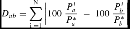
Occurring in the middle of the clearances, the 1971 census recorded that more than one-quarter of the Caribbean-born population of Manchester and Trafford lived in the two wards of Moss Side. Within Moss Side, that population was particularly concentrated in the western part of the ward, in the area to be subsequently developed after the second major wave of clearances from the mid-1970s as the Alexandra Park Estate. The year 1971 represented the apogee for the Caribbean-born population of Manchester in demographic terms as it had increased by 70 percent over the previous decade. Despite this robust growth, standardization of areal units reveals that West Indians and New Commonwealth immigrants still constituted only a small minority of this “ghetto” with only 16 percent of the population. Even in the west of the ward, New Commonwealth immigrants still only made up 18 percent of the total. While low, these figures contrasted sharply with neighboring wards such as Hulme, where West Indians made up less than 5 percent of the ward's total population. For Moss Side, the issues were those of scale and perception. Despite the statistics, Moss Side was perceived as being a ghettoized area in comparison to its surrounding wards and the more distant suburbs; it was a disproportionate center of black settlement in the city. This is reflected in the ward's contribution to a dissimilarity index for the Caribbean population calculated for all 54 wards across the districts of Manchester and Trafford (i.e., the proportion of overall dissimilarity for the year for which Moss Side alone was responsible). The dissimilarity index is a key measure of segregation in the social sciences and Peach (Reference Peach2009: 1382–83) contends that it remains one of the most authoritative. The index provides a measure of evenness; it identifies how well distributed a subject group is within the universe, where groups a and b constitute nonoverlapping populations (Dorling and Rees Reference Dorling and Rees2003: 1289–90; Massey and Denton Reference Massey and Denton1988: 284).Footnote 5 It can be operationalized using this formula,
 $$\begin{equation*}
D_{ab} = \sum\limits_{{\rm i}\;{\rm = 1}}^{\rm N} {\left| {100\;\frac{{P_a ^i }}{{P_a ^* }}\; - \;100\;\frac{{P_b ^i }}{{P_b ^* }}} \right|}
\end{equation*}$$
where Dab is the dissimilarity index for the Caribbean-born population; Pi a is the Caribbean-born population, a, in ward i; b is the rest of the population; and * indicates the study area of Manchester and Trafford.Footnote 6 Applying the dissimilarity index to census data shows that in 1971 the Caribbean-born population was highly concentrated, registering an index of 61 percent, while Moss Side with an index contribution of 12.4 percent alone accounted for a quarter of the entire unevenness in the Caribbean-born population across the entire 54 wards of Manchester and Trafford as a whole.Footnote 7
In the mid-1960s, it was anticipated that the redevelopment of Moss Side would play a key role in addressing what was already being perceived as a segregated area by dispersing its ethnic population more widely across the city (Observer 1967; Ward Reference Ward1971: 16). The prolonged process of slum clearance with houses listed for demolition for several years both added to and complicated this vision of population dispersal. While immigrants faced greater levels of discrimination in attempting to access housing in more desirable areas beyond the condemned zones, within them the situation worked to their advantage. It was easier to access properties that were already within clearance zones and that would be demolished in less than a year anyway (Barnett et al. Reference Barnett, Pickvance and Ward1970: 5).
Further north in Hulme, as the 1971 map in figure 3 shows, redevelopment projects were much further advanced. Manchester, unlike many city councils across Britain in this period, deliberately steered away from the high-rise model of comprehensive redevelopment and with the Hulme Crescents sought to emulate the Georgian elegance of Bath and London's Bloomsbury with sweeping curves and wide-open spaces. There was an earnest belief among planners that the deck-access design would replicate the old terraced streets and foster the same sense of community within a better standard of accommodation (Beckham Reference Beckham1978). Yet within just four years of topping out, the residents of the “New Bloomsbury” were already demanding to be rehoused as the Georgian dream fell victim to poor design, shoddy maintenance, and social problems (Ravetz Reference Ravetz2001: 229–30; Shapely et al. Reference Shapely, Tanner and Walling2004: 424–29). For the displaced residents of Moss Side in search of a better quality of life beyond the Victorian slums, the housing that awaited them in Hulme was identified by one council official as “virtually all Council, all modern, mostly in the air and universally infamous, throughout the city; to describe it as ‘modern, purpose-built flats’ is somewhat of a euphemism” (Race Relations and Immigration Sub-Committee 1979/80: 770).
Using areal interpolation to compare the 1971 and 1981 censuses (table 2) based on the administrative boundaries of the latter, the entire population loss across all the inner city wards of southern Manchester, excluding Hulme, is particularly striking with a 27 percent decline over the decade. Beyond Moss Side and Hulme, the proportion of Caribbean-born residents in the total population of these inner-city wards remained relatively consistent. There were, however, significant changes in the position of West Indians within the wider immigrant population, as in the eastern wards of Ardwick, Longsight, and Rusholme, their share of the New Commonwealth born population increased by 15 to 25 percent. Despite these movements to neighboring wards, the greatest demographic impact of the 1968–73 clearances appears to have been concentrated on the internal redistribution of ethnic minority populations within Moss Side and Hulme.
Results of areal interpolation of population, tenure, and family structure between 1971 and 1991 based on 1981 ward boundaries

Source: 1971–91 Census of Population.
Between October 1970 and April 1973, 3,754 households were directly affected by the clearances in Moss Side of which 30 percent were identified as colored; however, nonwhite households represented 43 percent of those that were rehoused in Moss Side and Hulme during the same period (Ward Reference Ward1975: 379). Based on the 1981 ward boundaries of Moss Side, the ward's population decreased by 15.7 percent over the decade that followed 1971, while its Caribbean-born population fell by 36.9 percent to 1,436 by 1981. In the wake of the clearances not only did Moss Side's Caribbean-born population appear to be disproportionately affected by the program (due to the physical conditions and tenure of their pre-1971 housing), but their share of the ward's total population declined to under 10 percent. In contrast to the population loss of its neighboring wards, Hulme experienced 8.5 percent growth in its total population, within which there was a doubling of its Caribbean-born residents to 1,115 by 1981. Across the same decade, the number of Hulme's residents that were born in the New Commonwealth tripled, resulting in the Caribbean-born becoming a minority within its nonwhite population.
The impact of the clearances of the early 1970s is reflected in the decline in the 1981 dissimilarity index for the Caribbean-born population for Manchester and Trafford, which fell to 47.7 percent while the proportion for Moss Side fell by 5 percent points over the course of the previous decade to 7 percent. But despite these transformations and population shifts, broader demographic trends were off-setting the impacts of this dispersal. Across the nine inner-city wards of South Manchester, the Caribbean-born population fell by 11.5 percent between 1971 and 1981, while the overall population fell by 25 percent. Lowering population densities had been seen as one of the key objectives of the clearance scheme, but the problem for planners was that those densities were not being lowered evenly across racial lines. In Hulme, the only one of the nine wards to see its population rise during the 1970s, interpolation reveals that the Caribbean-born residents explained 57 percent of the population growth that was experienced in the ward during that time. Furthermore, the clearances provided the opportunity for many white residents to “escape” from an area that was already well established in the public imagination as a “ghetto.” According to the memoirs of community activists at the Moss Side Family Advice Centre,
many white people demonstrated their racist nature when the crunch finally came by getting out of the area as quickly as possible instead of staying to help the fight against council redevelopment plans, which would effectively scatter the multi-racial population of Moss Side to the four winds. (Family Advice Centre 1981: 6)
In terms of housing tenure however, the changes were even more dramatic. Moss Side witnessed a sevenfold increase in the share of its population in social housing over the 20-year period. Hulme was already completely dominated by council estates in 1971 and remained so in 1991, with 96 percent of its population in social housing. Ardwick, the site of another major housing development (Shapely Reference Shapely2007: 176–79), also saw the vast bulk of its populace transferred from the private to public housing sectors, but beyond these wards, the same trends were evident but were modest in comparison.
At ward level, family structures appeared much more consistent than the previous two indicators. All wards witnessed a steady decline in the number of households consisting of families with two or more children. However in Hulme the collapse was much more severe than elsewhere. To provide some context, the average for such households across Manchester and Trafford districts as a whole in 1981 was 18.3 percent, so most of these inner-city wards displayed relatively high numbers of larger families at that time. In 1991, the figure for Manchester and Trafford was 16.1 percent, with Moss Side, Clifford, and Longsight registering substantially higher proportions of larger families.
New Designs and Divisions: Princess Road and the Alexandra Park Estate
In addition to the housing programs of the city authorities, new infrastructural developments also had a profound effect in adding to the dispersing and socially divisive effects of slum clearance. Running along the northern edge of the Hulme clearance area was the Mancunian Way, the new urban motorway that skirted the northern edge of the district and divided the residential areas south of it from Manchester's Central Business District. As Brook and Dodge (Reference Brook and Dodge2012: 80) have argued, the elevated nature of much of the motorway has meant that it has historically acted as both a visual blockade and a physical boundary. Running perpendicular to the Mancunian Way and performing a similarly divisive role was Princess Road, which was widened in the 1960s and physically divided Moss Side in two. The upgrading of Princess Road had a transformative and entirely negative environmental and social impact on neighborhoods that had already been completely razed and rebuilt, and was the focus for a series of protest campaigns at the end of the 1970s (Fraser Reference Fraser1996: 52–53; Haslam Reference Haslam2000: 225; Parkinson-Bailey Reference Parkinson-Bailey2000: 158; Walsh Reference Walsh1993: 54).
Manchester University also contributed to the spatio-demographic upheavals of the period as the institution embarked on a rapid extension of its estate in developments that reflected the expansion of higher education more generally during the 1960s. It was also emblematic of a cultural shift in the tertiary education sector as accommodating students became increasingly an institutional function rather than a private-sector enterprise (Pullan with Abendstern Reference Pullan and Abendstern2004: 26–27). Where students had previously been more embedded within the neighboring districts of Greenheys, Moss Side, and Rusholme through the private-sector housing market, the retreat to within the confines of the university campus was symbolic of an increasing socioeconomic divide between students and local youths, a divide thrown in to starker relief by the economic collapse of the late 1970s. New student residences were damaged by vandals “thought to have come from Moss Side” (ibid.: 8). Meanwhile, at the northern end of the university precinct, two streets of Georgian terraces fell to the bulldozer to make way for social science buildings (ibid.: 20). Inner-city south Manchester in the 1970s was at the nexus of emergent trends in the areas of housing, transport, and education policy and both high-level and local political vicissitudes had profound implications for the area's social and physical development.
By the mid-1970s the failures of multistory and deck-access designs such as those in Hulme were already clearly apparent to city planners (Haslam Reference Haslam2000: 226–27; Shapely et al. Reference Shapely, Tanner and Walling2004: 427–29). MCC decided to take a different approach with the Moss Side clearance from 1978, opting to follow the Radburn principles for the redevelopment of the area of Moss Side to the west of Princess Road with lower density housing units in a configuration inverse to that normally applied with backyards facing each other and road access being placed behind the properties. The objective was to emulate the “garden city” model and to encourage greater social interaction, but the approach is generally considered to have failed in almost all its manifestations around the globe (Ferrari and Lee Reference Ferarri, Lee and Beider2007: 45; Woodward Reference Woodward1997). Nevin and Leather (Reference Nevin, Leather, Malpass and Cairncross2006: 107) note that even at the time of Alexandra Park's construction, the Radburn plan was already considered “the most unpopular in the national local authority portfolio.” Although it was intended to foster a sense of community, the design fed residents’ insecurities by militating against the informal surveillance of public space and the networks of laneways were seen as creating opportunities for crime (Cox and McLaughlin Reference Cox and McLaughlin1994; Weatherburn et al. Reference Weatherburn, Lind and Ku1999: 256). Notwithstanding these reservations Manchester and Salford City Councils pushed ahead with Radburn projects in Longsight, Beswick, Harpurhey, and Ordsall, in addition to the Moss Side development (Nevin and Leather Reference Nevin, Leather, Malpass and Cairncross2006: 106–7). As figure 2 earlier identified, there was a substantial amount of commercial property across the Hulme and Moss Side districts, with neighborhood shops making an important social as well as economic contribution to the locality. Much of this was swept away with the second-wave clearance of Moss Side, as planners replicated the same mistakes they had made previously during the Hulme clearances.
Returning to figure 3 the bottom map shows the situation in 1981 and the impacts of this next phase of comprehensive redevelopment upon the social landscape. Inner-city south Manchester was by now overwhelmingly dominated by social housing while parts of Hulme had been given over to owner occupation in those parts of the estate where there was sufficient demand amongst tenants to take advantage of the 1980 Housing Act, which gave them the “right to buy” their properties from the local authority. In the first year of the scheme alone, some 86,200 tenants across the country exercised their legal right to buy their homes from their local councils (Balchin et al. Reference Balchin, Roden, Isaac, Balchin and Roden1998: 67–69), although it is highly unlikely that such enthusiasm extended to the residents of the Hulme crescents. This marked a watershed moment in the history of postwar housing in the United Kingdom with the residualization of social housing as state provision gave way to private-sector development in the building of new homes (Hanley Reference Hanley2008: 100). However, in 1981 the housing landscape was one in which the residents of Moss Side and neighboring districts was now heavily dependent on the state, a complete transformation from the situation just 15 years before.
Initially the new housing on the Alexandra Park Estate was seen as offering some of the most attractive accommodation in Moss Side and Hulme. However, the new developments were also perceived by some residents as lacking the dense social networks of family and neighbors of the remaining Victorian terraces in east Moss Side (Greater Manchester County Record Office 1987a, 1987b). By the mid-1990s, the Alexandra Park Estate was increasingly stigmatized by outsiders as an enclave of drug crime and described by some who lived on the estate as a “muggers paradise” (Cox and McLaughlin Reference Cox and McLaughlin1994: 30). The fusing of perceptions of criminality with the built environment is reflected in Haslam's description of the area:
The estate itself became a network of streets, crescents and closes, with squat, sandy-coloured brick houses each with a patch of uncultivated back garden. The outer ring of houses backing onto Princess Road and Quinney Crescent were given tiny slit windows; the Estate today still gives the impression that it's some kind of stockade, adrift and hostile. (2000: 227)
This stigmatization of Alexandra Park Estate was reinforced as several of Manchester's leading drug gangs in the 1990s took their names from the landscape of the estate—Gooch Close, Doddington Close, and the Pepperhill pub (Bullock and Tilley Reference Bullock and Tilley2002). But according to the work of a local photographer who charted the changing identities within Moss Side, the failures of Radburn could be most clearly discerned and contrasted in how it affected social life in the area. Here the photographer reflects on a typical street scene and the stark differences between the Alexandra Park Estate and the neighboring Victorian terraces just across Princess Road,
All these people are related to each other in one way or another. Some are family, some friends, some neighbours. A scene like this can be seen daily around the older streets of Moss Side in summer. It's very rare to see the same thing only four hundred yards away on the Alexandra estate. (Greater Manchester Country Record Office 1987a)
Comparing the 1981 and 1991 census reveals the population dynamics in southern Manchester after the construction of the Alexandra Park Estate and before the demolition of the Hulme crescents (table 2). The Caribbean-born population of Moss Side based on its 1981 census boundaries decreased by more than a third to 933 people, while the equivalent population in Hulme fell by 70 percent to 334. As in the previous decade, redevelopment was one of the forces fueling internal migration; however, from the 1980s return migration to the Caribbean and increasing mortality amongst the first generation of migrants who arrived in the 1950s also had a significant impact (Byron and Condon Reference Byron and Condon2008: 217–26). Yet despite the stark overall population decline in Moss Side, its proportion of Caribbean-born residents almost doubled to 16.9 percent and its proportion of the Caribbean dissimilarity index for Manchester and Trafford remained almost unchanged from 1981 at 6.86 percent, underlining the longer-term demographic impact of differential patterns of commitment to the area among white and black residents, which had been observed by Ward back in 1979 (209).Footnote 8
Disaggregating these census statistics through interpolation onto western, eastern, and southern Moss Side reveals that the clearance areas that reshaped the ward before 1981 maintained their own distinctive demographic dynamics (table 3). In west Moss Side, as the Alexandra Park Estate was affected by drug crime and the declining condition of estate housing and communal spaces, so it lost 40 percent of its total population in the decade before 1991. During this time the Caribbean-born residents became more than a fifth of the area's total population, living almost exclusively in social housing. In east Moss Side the total population fell by more than half while in the south of the ward, it was stable. Whereas the Caribbean-born population had declined by 7.8 percent in west Moss Side between 1981 and 1991, in east Moss Side it fell by almost half, while in south Moss Side, which had been largely unaffected by such large projects of urban redevelopment, its Caribbean-born residents increased by 20 percent. Within the wider New Commonwealth migrant population, the Caribbean-born population held up most in the clearance areas of Moss Side east and west, which had respectively marked the initial gateway zone and areas of aspiration and establishment for the community. The microgeographies of immigrant settlement that had emerged in the 1950s and 1960s therefore retained their own divergent character as they were reshaped differently by the clearance projects of the 1970s and 1980s.
Results of areal interpolation of population, tenure, and family structure within Moss Side and Hulme based on clearance areas

Source: 1971–91 Census of Population.
In terms of housing tenure, the redevelopment resulted in high proportions of the population living in social housing, which appear to have been much less affected by the “right to buy” reforms of the early 1980s. Also worthy of note is the singular collapse of the Hulme estate's family structure, with only 7.1 percent of households being home to two or more children, a figure less than half that of Manchester and Trafford as a whole. In this depressing statistic we can directly trace the hand of the MCC, who had long since made a commitment to remove all those with youngsters from the estate, such was their acknowledgment that it had become no place to raise a child (Ravetz Reference Ravetz2001: 230).
Legacies
One of the most striking legacies of the three decades of redevelopment that remade Moss Side from the late 1960s was the rapid movement of the Caribbean population into public housing. While these trends were paralleled elsewhere in Britain (Peach and Byron Reference Peach and Byron1993, Reference Peach and Byron1994; Peach and Shah Reference Peach and Shah1980), the scale of the clearances in south Manchester gave them a particular inflection. Despite limited access to public housing before 1968, within a decade it was estimated that 59 percent of the Caribbean population of Manchester were in council housing compared to a national average of 45 percent for this ethnic group across the country as a whole (Race Relations and Immigration Sub-Committee 1979/80: 784). Mapping housing tenure in 2001 for the ethnic Caribbean population emphasizes the continuing importance of social housing in Moss Side and inner-city Manchester for this group (see figure 4). However, in wards where the housing stock was not transformed by major clearances, higher levels of Caribbean owner-occupation are today evident. This is the case in Whalley Range, Levenshulme, and the eastern wards of the neighboring borough of Trafford, such as Talbot and Clifford.
Housing tenure of ethnic Caribbean population, 2001.

Fifty years after the mass migration of the 1950s, the community institutions of Moss Side remain as key structures in the lives of first generation migrations, although their children are much more likely to reside elsewhere in the city. By 2001 14.1 percent of Greater Manchester's Caribbean-born residents lived in Moss Side compared to only 7.7 percent of those who identified themselves as ethnically Caribbean or mixed. Half of the ethnic Caribbean population of Moss Side were Caribbean born whereas immigrants represented a quarter of the ethnic Caribbean population for Manchester's other city wards. To the aging Caribbean immigrants living in Moss Side, what had once been a gateway area of mobility has remained a hub for social networks, organization, and interactions, particularly centered on the church (Scharf et al. Reference Scharf, Phillipson and Kingston2003).
The demographics of Manchester's black population have been significantly reconfigured over the past two decades as the number of city residents who identify as black African have increased by more than 250 percent to 25,718 and the mixed white-black Caribbean increased by 57 percent to 8,887 between 1991 and 2011, while the black Caribbean ethnic group has remained stable at just under 10,000 during the same period. In the 2011 census, two-thirds of Moss Side's residents identified as nonwhite, although only 10 percent of these were black Caribbean and 17 percent were black African. That Moss Side has continued to be imagined in public discourse as a “black space” is due as much to its continuing function as a gateway for new forms of African migration as to the historical legacy of its Caribbean community. The microgeographies of migrant settlement that emerged in the 1950s and were reshaped by slum clearance in the late 1960s have been reinforced over time so that in 2011 there was a substantial concentration of Somali settlement in East Moss Side partly due to public housing allocation, with Jamaican residents clustered north of Alexandra Park in West Moss Side.
Conclusions
We have argued in this article that debates on current and historical patterns of urban ethnic segregation in the United Kingdom have tended to approach the issue with little reference to the dramatic remaking of British cities in the postwar period through successive experiments in comprehensive redevelopment. This article has attempted to draw across these diverse and largely discrete literatures in the fields of geography, history, and urban sociology to demonstrate that those processes are in fact integral to an understanding of the contemporary urban ethnic landscape of the United Kingdom and the residualization of particular groups within social housing (Burrows Reference Burrows1999). We have shown that these processes have both clear, and spatially nuanced qualitative and quantitative dimensions and that any analysis that takes just one of these approaches will reveal only part of the true and rich picture.
By standardizing census boundaries and allowing for disaggregation of demographic data onto changes in the built environment, areal interpolation provides a powerful tool for analyzing the internal dynamics of ethnic residential settlement within Moss Side and surrounding neighborhoods; areas that this article identifies have undergone radical physical and social transformation in the postwar period. The experimental housing agendas for which areas like Moss Side formed the policy laboratory had considerable impacts in driving patterns of ethnic settlement over the ensuing 50 years and bear considerable responsibility for much of the “reputational stigma” (Slater and Anderson Reference Slater and Anderson2012: 530–46) that the area has witnessed, particularly in the last two decades of the twentieth century. However, in this respect, the experience of inner-city South Manchester as an area heavily characterized by the development of deprived public housing schemes over the study period fits into wider negative discourses of socioeconomic marginality associated with council estates in the United Kingdom and that transcend ethnic categorizations (Jones Reference Jones2011: 13–38). While contemporary debates have increasingly cast patterns of ethnic settlement as driven by choice and aspiration (Dorling Reference Dorling2013; Easton Reference Easton2013), using GIS to visualize the microgeographical experiences of Caribbean immigrants reveals how residence was also shaped by changes in housing stock, policy interventions, and the life course of migrants. Areal interpolation also provides a spatial and statistical context that enables us to understand in new depth the intense mobility of ethnic populations within and across changing administrative areas such as Moss Side, which have been unfairly stigmatized as marginal and immobile ghettos when the historical and demographic record clearly point to a far more diverse and dynamic experience.


 Open access

