INTRODUCTION
This Special Section of Ancient Mesoamerica has multiple goals pertaining to “Project Altica,” undertaken by Nichols and Stoner in the Teotihuacan Valley, and for understanding early Mesoamerica in general. The first is to reignite interest in problem-oriented research on the Early and Middle Formative periods in the Basin of Mexico. Groups there participated in pan-Mesoamerican style horizons during the Early and Middle Formative periods, which provided a shared cultural foundation across Mesoamerica and established early long-distance trade networks (Grove Reference Grove and Rice1993; Henderson Reference Henderson1979; Pool Reference Pool2007; Rosenswig Reference Rosenswig2010; Willey Reference Willey1991). By the Late Formative, style horizons had broken down, giving way to a more balkanized cultural landscape as Mesoamerica's first cities turned their attention toward intraregional political economic consolidation, ultimately enabling the later expansions of Monte Albán and Teotihuacan.
Cycles of expansion and contraction of interaction are themselves important to understand the evolution of complex societies (Marcus Reference Marcus, Feinman and Marcus1998; Nichols and Stoner Reference Nichols and Stoner2019; Willey Reference Willey1991). The peaks of these cycles tend to attract more archaeological attention, as they feature dynamic interactions and rapid culture change across broad areas, such as the unification of material and iconographic styles across early Mesoamerica. The valleys of the cycles are equally valuable for understanding cultural evolution. A lower intensity or restricted geographic range of interactions over long distances foster regional divergences (i.e., drift) across the Mesoamerican cultural landscape. With regard to the Classic period Basin of Mexico, Teotihuacan did not emerge from nothing, and its foundation lay at a series of transitions beginning over a millennium prior.
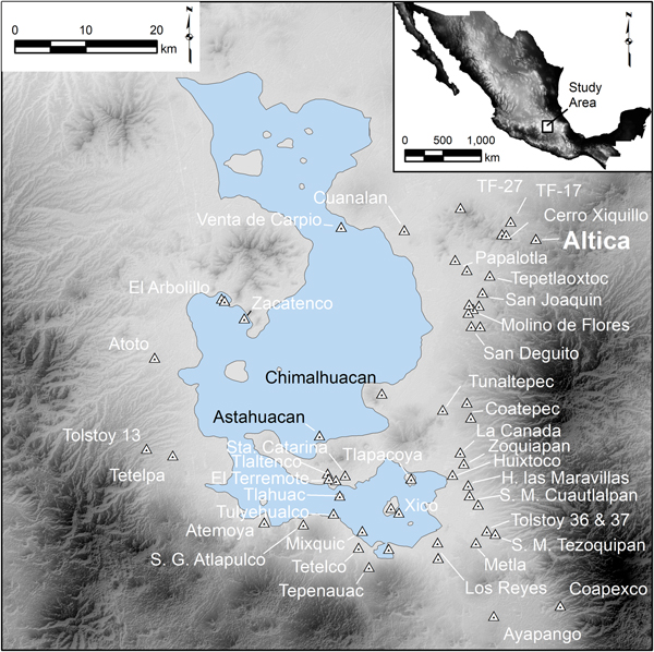
The second goal of this Special Section is to report the findings of our multidisciplinary research at Altica, the timing of settlement relative to broader Mesoamerican patterns, and its role in Formative exchange systems. Altica was initially discovered on survey during the Teotihuacan Valley Project in the 1960s (Figures 1 and 2; Sanders et al. Reference Sanders, West, Fletcher and Marino1975). A pilot study undertaken by Nichols and her former student Bridget Alex (Alex et al. Reference Alex, Nichols and Glascock2012) conducted compositional analysis of a sample of ceramics from Sanders's surface collections at Altica to find a substantial group of white-ware imports (Stoner et al. Reference Stoner, Nichols, Alex and Crider2015). Altica was also previously identified as significant for the distribution of Otumba obsidian during these early periods (Boksenbaum et al. Reference Boksenbaum, Tolstoy, Harbottle, Kimberlin and Neivens1987; cf. Healan Reference Healan2019; Johnson and Hirth Reference Johnson and Hirth2019). Our interest was piqued by the role of this site in early exchange networks, so we set out to establish a program of research at the site.
Early and Middle Formative Sites in the Basin of Mexico. Map by Stoner.

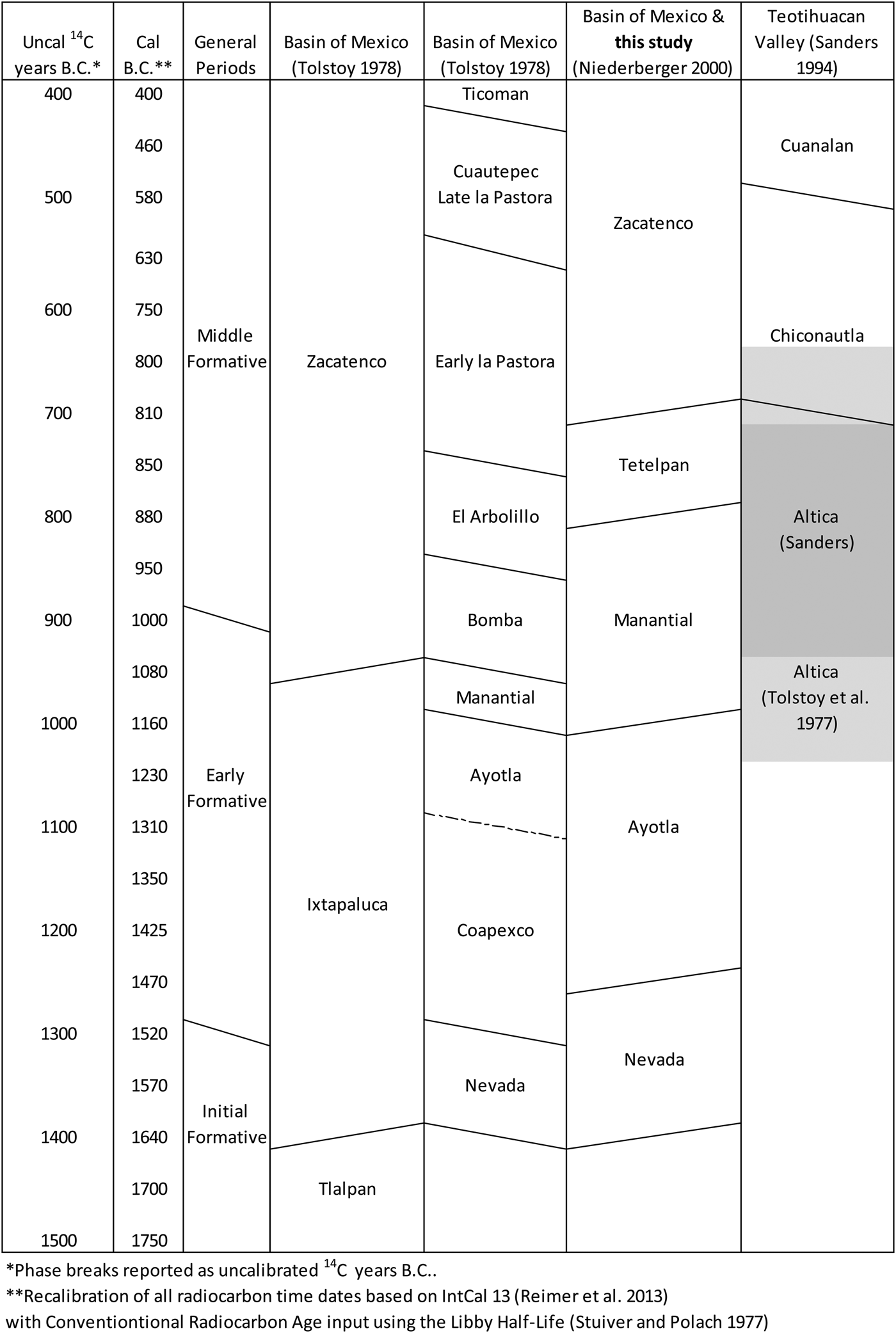
Chart showing the Basin of Mexico chronology. Primary occupation of Altica is shaded in the rightmost column. The darker shading is the “Altica Phase” created by Sanders, though we use the broader Basin of Mexico terminology. The lighter shading above and below the primary occupation represents a less intensive use of the site. Chart by Stoner.

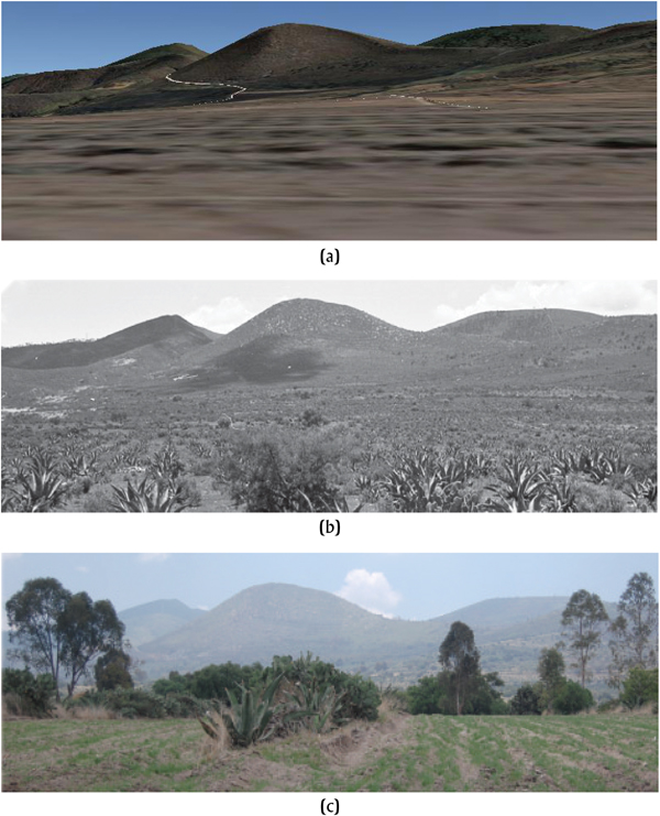
Locating the site again was not simple. In retrospect, the reported location of the site (Sanders and Gorenflo Reference Sanders and Gorenflo2007) sits about 1 km to the west of its actual location. Even the original aerial photos depicted the site location crossed out with the word “Incorrect” beside it. In 2013, we set out to find Altica on the ground. We eventually discovered a flat ridge with white-slipped ceramics on the surface. Confirmation that we indeed had found Altica later came from an unlikely source: comparison of the ridgelines from our 2013 site visit to the original panoramic photos taken during the 1960s survey (Figure 3). We had found the southwest corner of the site during our initial visit. Using Google Earth Streetview, we virtually moved over the landscape until the ridgeline appeared as it had in the 1960s and triangulated its coordinates to identify where the photographer was standing decades ago. We were in the field by summer 2014.
Mountain silhouettes, as seen from Altica. (a) Google Streetview. (b) 1960s survey photo. (c) Our 2013 visit to the site. All images facing north. Note that our 2013 visit encountered only the southern edge of the site. Photographs by Stoner.

As a result of Project Altica, we can demonstrate its primacy as the earliest known settled village in the Teotihuacan Valley, initiating a long history of continuous occupation leading to the founding of Teotihuacan on the valley bottom. Sites like Altica that have escaped urban sprawl represent opportunities to research the foundational processes of cultural evolution. Features undamaged by surface erosion and chisel plowing present a rare opportunity for excavation of intact cultural deposits. Burials recovered in pits excavated into the tepetate were analyzed for diet, health, geographic origin, and biological affinity (Storey et al. Reference Storey, Buckley and Kennett2019). Botanical remains (McClung de Tapia et al. Reference McClung de Tapia, Acosta-Ochoa, Martínez-Yrizar, Adriano-Morán, Cruz-Palma and Chaparro-Rueda2019) revealed a subsistence economy in transition. Ceramic (Jennifer Carballo, personal communication 2019; Oralia Cabrera, personal communication 2019; Stoner and Nichols Reference Stoner and Nichols2019) and lithic (Healan Reference Healan2019; Johnson and Hirth Reference Johnson and Hirth2019) analyses provide insight into how Altica fit within the broader regional cultural and economic systems.
The approximately 450-year occupation of Altica (ca. 1250–800 cal b.c.) reflects broad transitional trends sweeping across Mesoamerica as a whole. Beginning during the Manantial phase about 1150 cal b.c., emulation of Olmec-style symbols signficantly declined from previous levels during the Ayotla phase. A new, more decentralized horizon emerged to take its place. This is the transition from Horizon I to Horizon II in Rosenswig's (Reference Rosenswig2010) terms, or the black-ware to white-ware horizon in Grove's (Reference Grove and Rice1993; see also Henderson Reference Henderson1979; Pool Reference Pool2007; Stoner and Nichols Reference Stoner and Nichols2019; Tolstoy Reference Tolstoy and Diehl1989). Long-distance exchange of both prestige goods and basic materials intensified after that same date. Groups across Mesoamerica developed a more dependent relationship on agriculture, specifically maize. Settlement systems expanded and eventually became vertically ranked around “centers.” Finally, social inequalities began to develop in almost all regions, not just the few islands of complexity of the prior period (Rosenswig Reference Rosenswig and Hodos2016). We introduce this Special Section with an overview of how Altica reflects each of these pan-Mesoamerican trends.
A FRAME OF REFERENCE
Altica straddles the 1000 cal b.c. date identified as a major threshold of Mesoamerican change. Emulation of Olmec material styles on carved black pottery gives way to a more generalized horizon focused on white-ware bowls with double-line-break incision and “grater” motifs (Grove Reference Grove and Rice1993; Henderson Reference Henderson1979; Pool Reference Pool2007; Rosenswig Reference Rosenswig2010). The Basin of Mexico led this transition, as white-slipped pottery appears as early as the Ayotla phase (1450–1150 cal b.c.) on the types Pilli White and Pilli Red-on-White, which often display engraved Olmec motifs (Niederberger Reference Niederberger1976; Ochoa Reference Ochoa Castillo, Carrión and Cook2005). Additionally, line breaks occur on everted lips of the Ayotla-phase types Volcán Pulido and Tortuga Pulido, which may be the earliest line breaks documented in Mesoamerica (Niederberger Reference Niederberger1976:167, 170). White-slipped, flat-based bowls with double-line-break motifs circulating the interior lip dominate the following Manantial phase (1150–900 cal b.c.) as seen on types like Cesto White and Ixta White. There is little doubt that Manantial-phase white wares inherit their style directly from the earlier white wares developed within the Basin of Mexico, though the double-line-break and grater motifs derive from earlier Olmec-related designs, namely the cleft-head and sunburst motifs (Cheetham Reference Cheetham2010:337; Rosenswig Reference Rosenswig2010:219). At the same time, however, continued replication of contemporaneous pottery from the Gulf Coast greatly declines, as represented through a divergence in styles between the two regions. One style quickly replaces the other in the Basin of Mexico, and the transition begins in the Manantial phase (1150–900 cal b.c.) compared to the Guadalupe phase (1000–900 cal b.c.) in the Valley of Oaxaca (Flannery and Marcus Reference Flannery and Marcus1994), Nacaste phase (1000–800 cal b.c.) in San Lorenzo (Coe and Diehl Reference Coe and Diehl1980), Conchas phase (1000–900 cal b.c.) in the Soconusco (Clark and Cheetham Reference Clark, Cheetham, Leonor, de Carrión and Cook2005; Rosenswig Reference Rosenswig2010), Middle Barranca phase (1000–900 cal b.c.) at Chalcatzingo (Grove Reference Grove1987), Santa María phase (1000–700 cal b.c.) in the Tehuacán Valley (MacNeish et al. Reference MacNeish, Peterson and Flannery1970), and Atopula phase (1000–800 cal b.c.) in Guerrero (Henderson Reference Henderson1979; cf. Paradis Reference Paradis, Blomster and Cheetham2017). The timing puts the Basin of Mexico at the epicenter of the double-line-break white-ware horizon (Rosenswig's [2010] “Horizon II”; Grove Reference Grove and Rice1993; Henderson Reference Henderson1979; Tolstoy Reference Tolstoy and Diehl1989).
Niederberger (Reference Niederberger, Clark and Pye2000) argued that the Tetelpan phase (900–800 cal b.c.) featured Olmec deculturation, but this stems from the inclusion of double-line-break white wares with grater bases into the "Olmec" stylistic canon. We believe, to the contrary, that direct cultural interaction with the Gulf Coast recedes during the Manantial phase and the regional white-ware styles derive instead from vertical (generational) transmission from Ayotla-phase pottery styles, as is evident from the timing of the appearance of this pottery across Mesoamerica. Altica's major occupation ranges between about 1100–800 cal b.c., with minor occupations before and after, but it completely lacks any Olmec-style figurines or excised Olmec-style ceramics (with one possible exception), suggesting that at least some (not all) segments of the Basin turned away from the Gulf lowlands for inspiration by the Manantial phase. We entertain below the role of geography as well as time in the absence of Olmec-style excised ceramics at Altica. This rapid transition away from the Gulf Olmec for ceramics style inspiration did not take place simultaneously in all regions of Mesoamerica, or in all areas within regions. The Soconusco on the Pacific Coast, for example, maintained strong cultural ties with the Olmec heartland through the Epi-Olmec phase (Pool Reference Pool2007; Rosenswig Reference Rosenswig2010). Within the Basin of Mexico, the site of El Arbolillo displays excised Olmec motifs much later than other sites in the region (Tolstoy Reference Tolstoy1984).
The transitional period represented by Altica also features more widespread adoption of an agricultural economy after thousands of years dabbling with domesticated crops in a mixed subsistence strategy (Arnold Reference Arnold2009; Blake et al. Reference Blake, Chisholm, Clark, Mudar, Gebauer and Price1992; Clark et al. Reference Clark, Pye, Gosser, Lowe and Pye2007; Killion Reference Killion2013; McClung de Tapia et al. Reference McClung de Tapia, Acosta-Ochoa, Martínez-Yrizar, Adriano-Morán, Cruz-Palma and Chaparro-Rueda2019; Rosenswig et al. Reference Rosenswig, VanDerwarker, Culleton and Kennett2015; Storey et al. Reference Storey, Buckley and Kennett2019; VanDerwarker Reference VanDerwarker2006). Mesoamerica definitively proves that complex civilizations can develop without intensive reliance on agriculture (Niederberger Reference Niederberger, Clark and Pye2000; VanDerwarker Reference VanDerwarker2006), but addition of agricultural crops expanded the realm of opportunities that nascent elites exploited to elevate themselves. Early cultivation may have served to make edible plants more predictable and concentrated at specific geographic locations disturbed by human activity (Nichols Reference Nichols2015). Stored grains added stability to existing subsistence economies, enabling sustained permanent village occupations in relatively marginal environments. Surpluses were used in conjunction with rituals and feasts that allowed the sponsor to accumulate social capital essential for early status distinctions (Clark and Blake Reference Clark, Blake, Brumfiel and Fox1994; Hayden Reference Hayden, Price and Feinman1995). Changing subsistence eventually gave rise to a new worldview and religious programs (e.g., maize fertility cults, deities, and human sacrifice). Stored food also served to finance labor projects, including Mesoamerica's first monumental art and architecture (Benson and de la Fuente Reference Benson and de la Fuente1996; Cyphers Reference Cyphers2004; Flannery and Marcus Reference Flannery and Marcus2000; Joyce Reference Joyce2004; Love Reference Love2002; Niederberger Reference Niederberger1976; Sanders et al. Reference Sanders, Parsons and Santley1979; Serra Puche and Ramírez Sánchez Reference Serra Puche and Ramírez Sánchez2001; Stirling Reference Stirling1943).
Exchange systems during the Early Formative emphasize an externally focused economy in which elites sought exotic goods, materials, and ritual knowledge to set them apart from the general populace. After around 1000 cal b.c., exchange systems became more efficient due to systematization among a network of increasingly specialized and interconnected sites, each focused on different tasks within the commodity chain (Stark et al. Reference Stark, Boxt, Gasco, Lauck, Balkin, Joyce, King, Knight, Kruger, Levine, Lesure, Mendelsohn, Navarro-Castillo, Neff, Ohnersorgen, Pool, Raab, Rosenswig, Venter, Voorhies, Williams and Workinger2016). Improved provisioning mechanisms allowed utilitarian goods to circulate in larger quantities through domestic networks that branch out from earlier prestige trade routes (Hirth et al. Reference Hirth, Cyphers, Cobean, De León and Glascock2013; Pires-Ferreira Reference Pires-Ferreira and Flannery1975). This included more specialized systems of raw material extraction, such as that established in the Teotihuacan Valley for the movement of Otumba obsidian (Healan Reference Healan2019; Johnson and Hirth Reference Johnson and Hirth2019). These developments enabled sites like Chalcatzingo to emerge as gateways linking multiple regions through trade (Burton and Krinsley Reference Burton and Krinsley1987; Charlton Reference Charlton1984; Grove Reference Grove1987; Healan Reference Healan2019; Hirth Reference Hirth1978; Pires-Ferreira Reference Pires-Ferreira and Flannery1975). Despite the emergence of a new domestic provisioning network for utilitarian goods, the quest for exotic prestige goods never disappeared completely from any Mesoamerican group.
Pottery production and exchange mirrors the change seen among the obsidian tool industry. The earliest demonstrated pottery exchanges occurred in low frequencies over long distances during the Early Formative, featuring the trade of mostly fine-paste white and gray ceramics (Blomster et al. Reference Blomster, Neff and Glascock2005; Cheetham Reference Cheetham2010; cf. Grove Reference Grove and Rice1993; Flannery and Marcus Reference Flannery and Marcus2000; Flannery et al. Reference Flannery, Balkansky, Feinman, Grove, Marcus, Redmond, Reynolds, Sharer, Spencer and Yaeger2005; Neff et al. Reference Neff, Blomster, Glascock, Bishop and Blackman2006a, Reference Neff, Blomster, Glascock, Bishop and Blackman2006b; Sharer et al. Reference Sharer, Balkansky, Burton, Feinman, Flannery, Grove, Marcus, Moyle, Price, Redmond, Reynolds, Rice, Spencer, Stoltman and Yaeger2006). In central Mexico, carved pottery with Olmec designs is overwhelmingly of local production and the symbols themselves disappear, or become absorbed into the new stylistic canon, by about 1100 cal b.c., with some exceptions of legacy expression at places like El Arbolillo (Tolstoy Reference Tolstoy1984). In some regions, the trade of Olmec-style symbols continues for centuries on other exotic media (jade, serpentine, and iron ore), but once local symbols become freely replicated by local potters (Stoner and Nichols Reference Stoner and Nichols2019) they lose the exclusivity that previously made them prestigious (Neff Reference Neff and Martinón-Torres2014; Stark Reference Stark, Scarborough and Clark2007). Fine-paste Xochiltepec White and Atoyac Fine Gray are visibly distinguishable from local pottery and could not be imitated using local materials, thus they remained prestigious for some time into the early Middle Formative.
After 1000 cal b.c., we still see quite a lot of pottery exchange, but over much more restricted geographic areas (Stoner and Nichols Reference Stoner and Nichols2019). The white-slipped pottery mentioned above was the focus of this trade. Its exchange through more decentralized networks and over more restricted geographic scales implies that the regional cultural distinctions observed during the Late Formative is the result of a longer process of divergence rooted in the early Middle Formative.
Status differences at settlements across Mesoamerica started to take hold around this time as well. The earliest clear evidence of an emerging elite class in Mesoamerica appears earlier at places like San Lorenzo, San José Mogote, and Paso de la Amada (Clark and Blake Reference Clark, Blake, Brumfiel and Fox1994; Cyphers Reference Cyphers1997; Flannery and Marcus Reference Flannery and Marcus2000). At each of these places, monumental art, architecture, and import of exotic prestige goods benefited an exclusive class of elites or emerging elites. After 1000 cal b.c., monumentalism in Mesoamerica became bigger and more widespread, demonstrating the increased power and labor mobilization skills of the elite class (González Lauck Reference González Lauck1988, Reference González Lauck, Benson and de la Fuente1996; Grove Reference Grove1987; Joyce Reference Joyce2004; Love Reference Love2002; Pool Reference Pool, Arnold and Pool2008). Early evidence for status differentiation in central Mexico is less demarcated and typically presents as individual graves that possess more offerings than others (Niederberger Reference Niederberger, Clark and Pye2000; Tolstoy Reference Tolstoy and Diehl1989). This leads us to suggest that until late in the Middle Formative—when the earliest ballcourt (likely a communal structure) was constructed in the region (Serra Puche and Ramírez Sánchez Reference Serra Puche and Ramírez Sánchez2001)—the primary means of obtaining social status was through exotic trade goods used in visual displays at local feasts or rituals (Clark Reference Clark1997; Helms Reference Helms1993; Stark Reference Stark, Blomster and Cheetham2017). Gradually over time, however, external finance gave way to internally focused activities such as the construction of civic-ceremonial architecture (Grove Reference Grove1987; Serra Puche and Ramírez Sánchez Reference Serra Puche and Ramírez Sánchez2001), irrigation canals (Nichols Reference Nichols1987), and control over developing settlement hierarchies (Sanders et al. Reference Sanders, Parsons and Santley1979).
Finally, settlements systems in each region began to fill out. Prior to the 1000 cal b.c. mark, socially differentiated villages and centers were few and far between across Mesoamerica. Rosenswig (Reference Rosenswig and Hodos2016) refers to this as an archipelago of complexity that was united through a common set of rituals and iconography (see also Stark Reference Stark, Blomster and Cheetham2017). After 1000 cal b.c., most areas within regions filled up with settled villages. Whether sedentary agriculturalists fissioned off from earlier centers and colonized new areas, or Archaic hunter-gatherers who previously utilize those lands underwent an in situ shift to village life is a major question. In the Basin of Mexico, the longest continuous cultural sequence is found at the southern site of Tlapacoya/Zohopilco. People certainly used the northern Basin for millennia, but we have not yet detected any initial ceramic (Nevada phase) occupations there. Regardless of whether colonization or cultural diffusion was mechanism for the transition to sedentism and adoption of a shared set of ceramic material culture, regions become more fully settled after the 1000 cal b.c. date.
In what follows, we present the role of Altica in this transition period from the Early to Middle Formative. Altica is really a sign of the times. We do not propose that the site was a driver of any of these changes, but it does reflect the broader Mesoamerican processes mentioned above. The brief 450-year occupation of Altica at this time of dramatic change permits a larger discussion of broad-scale patterns in Mesoamerica as a whole. The discussion here is brief, but in the process we introduce each of the individual contributions in the Special Section, which should be consulted for greater detail.
ALTICA NATURAL ENVIRONMENT
Altica is situated at the eastern margin of the Teotihuacan Valley about 1.2 km north of the crest line of the Patlachique Range. The pyramids at Teotihuacan are visible from the modern town of San Francisco Tlaltica, from which the site derives its name. The site occupies a relatively flat ridge at a high elevation (2,546 m above mean sea level). A 10-minute walk south from the site would set the pedestrian on a downhill route into the Texcoco region of the Basin, or east into Tlaxcala/Puebla. Though rugged, the potential of the latter route of transportation is demonstrated by the recent construction of Autopista Texcoco-Calpulalpan (HWY 136) that runs along the southern piedmont of the Sierra de Patlachique.
Altica lacked the biodiversity that places like Tlapacoya enjoyed in the lacustrine environments in the southern Basin. Not only did the lake provide dietary diversity based on aquatic species, frequently depicted on ceramic vessels at Tlapacoya (Niederberger Reference Niederberger1976), but a recession of the shoreline during Manantial times left behind fertile sediments. The diversity of wild resources and fertile soils made the southern Basin lake environment in general a prime zone for early agriculturalists transitioning from a foraging lifestyle. Altica is situated about 300 m higher in elevation than most contemporaneous settlements in the southern Basin. Climate in the south is a little warmer and notably wetter than northern portions of the Basin. The northern Basin receives less rainfall and tends to be cooler. Frost is a danger for crops throughout the Basin but it tends to be worse in the valley bottoms, which likely explains the placement of Altica high in the Patlachique Range rather than on the Teotihuacan Valley bottom (Nichols Reference Nichols1987; Sanders Reference Sanders and Wolf1976). These factors coupled with sheet erosion suggest that Altica was probably not established in this location because it was prime land for agriculture.
Soils at Altica are underlain by tepetate, a compacted bedrock composed of compressed volcanic tephra (mostly) deposited as hot mudflows (lahar) and may be weakly welded. Tepetate on hillsides with shallow soils poses serious problems for agriculture, as these tend to be recent, in geological terms, volcanic formations in a semiarid climate where soil formation is slow. Tepetate is relatively impervious to water, which facilitates rapid run-off of rainfall that causes devastating erosion and reduces or destroys agricultural productivity. While the landform may have been suitable for maize agriculture during the early years of Altica's occupation, it quickly lost agricultural productivity due to the soil erosion that came with forest clearance. Terracing could have reclaimed some productive potential, but this technology was not applied to the region until Aztec times. This was not an ideal situation for early agriculturalists who increasingly relied on a maize-based diet (McClung et al. Reference McClung de Tapia, Acosta-Ochoa, Martínez-Yrizar, Adriano-Morán, Cruz-Palma and Chaparro-Rueda2019; Storey et al. Reference Storey, Buckley and Kennett2019). Much of the eroded soil ended up in low-elevation saddles to the east and south of the site, which display rather deep soils by comparison. If we assume that most of those deeper soils in the saddle accumulated from the site of Altica, we can estimate at least 50–75 cm of soil deflation at the site since its Early Formative occupation until today.
SURVEY, EXCAVATION, AND SITE FORMATION PROCESSES
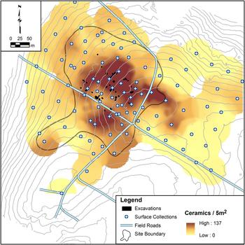
Fieldwork began in the summer of 2014 with a systematic survey including 5 × 5 m surface collections conducted on a 50-m grid (70 grid collections; Figure 4). Survey aimed to delineate the extent of the site and areas of greatest artifact density. We opportunistically placed 31 additional collection squares within the internodal spaces on the grid to augment collections with high material concentrations. All cultural materials were collected. Obsidian and ceramic density peak near the highest elevation point of this broad ridge, but differential soil deflation caused by erosion seems to have augmented this pattern. Excavations in those locations revealed soils no more than 10–15 centimeters deep before encountering tepetate. No clear cultural features were identified on the higher portions of the site, though chisel plowing might have obliterated any that had once been there. Formative ceramics cover about six hectacres, but we concentrated excavations over about one hectare with a high density of surface material, a relatively isolated Formative occupation, and a landowner who granted permission for excavations. Other areas of the site were eroded down to tepetate and no surface features were observed in those locations. We anticipate that there may be intact features elsewhere at the site for future researchers to encounter. The main site area of Altica that we excavated is overwhelmingly dominated by Early and Middle Formative materials, but other portions of the site possess very small Classic and Aztec occupations.
Ceramic concentrations from surface collections. Darker areas represent a higher concentration of sherds in a standard 5 × 5 m surface collection. Guillermo Acosta generated the digital elevation model (DEM) for the site from drone-based photogrammetry. Stoner filtered out vegetation to derive the bare earth DEM and constructed 1-m contours, seen here.

Mejía-Rámon, Barba, Ortiz, and Blancas (Mejía Ramón et al. Reference Mejía Ramón, Barba, Ortiz and Blancas2019) conducted magnetometer survey at Altica to identify potential intact features. We had intended to conduct electrical resistivity as well, but water saturated the ground during our entire field season, rendering any electrical technique of little use. Despite interference from volcanic rocks, which can be expected with magnetometry in volcanic regions, a number of anomalies were identified. Many of these turned out to be false hits caused by a burned tree root or natural andesitic rocks, but investigation of many anomalies identified cultural features dug to varying depths into the tepetate itself.
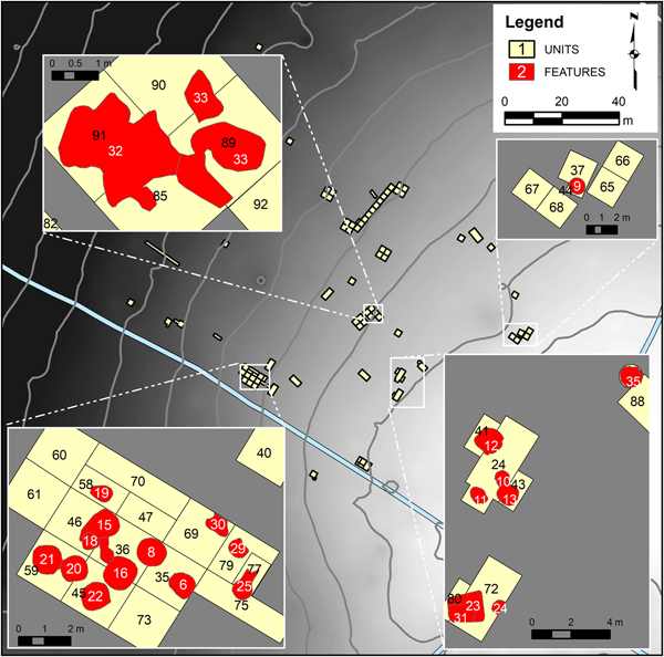
In total, we excavated over 460 m2 at the site (Figure 4). We identified 25 definite features of ancient and human origin (Figure 5). Some other features contained cultural materials but were irregularly shaped, suggesting a natural origin. The only intact soils at the site were either those that filled pits dug into tepetate or limited areas of the site where deeper soils avoided the plow. We emphasize this because, since the features were excavated into bedrock, it was an easy task to differentiate intact cultural features from the surrounding matrix. In almost all cases, once the plow zone was removed, the dark features stood in stark contrast to the hard, light-colored tepetate. Furthermore, despite the temporally mixed fill of the pits (see below discussion), these features are typically better preserved than those excavated into a soil matrix.
Site map, showing areas of excavation and distribution of excavated features. Many parts of the site were water logged during the excavation season and could not be accessed. Map by Stoner.

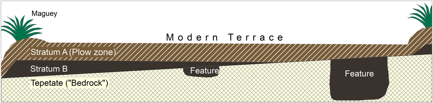
In very few places, excavations revealed an intact soil horizon (Stratum B) beneath the plow zone (Stratum A), which was also very easily recognized during excavation (Figure 6). Modern terracing, erosion, and chisel plowing have completely obliterated any remaining intact soil horizons elsewhere. Stratum B is an almost-black, sticky, silty clay that is likely related to the Noche Buena formation found throughout the central Highlands, which provided clay for production of pre-Hispanic pottery (Hopkins Reference Hopkins1995; Slayton Reference Slayton1985). Stratum B is considered a light-density midden accumulation, but no floors were detected that would indicate ancient living surfaces of differing age. Similar soils fill almost all features excavated on site.
Generalized profile of the site, showing the complete removal of Stratum B and all overlying layers. What remains of Stratum B is typically found on the western side of the modern terraces. Maguey bancals separate the terraces. All features intrude into tepetate bedrock. Image by Stoner.

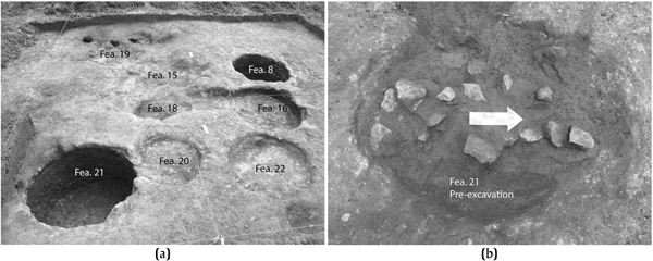
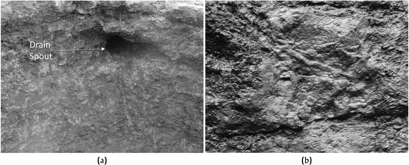
All features identified penetrated into tepetate. We emphasize that the local tepetate is relatively soft for bedrock, but the pits would have likely taken days or longer to excavate using crude chopping tools and wooden digging sticks. They took the form of regular geometric shapes, such as cylinders, basins, and rectangles (Figure 7). The impressions of individual tool strikes are visible on the walls of the pits (Figure 8). Based on the small size of the individual marks, thousands of strikes were required to make each feature. The inhabitants of Altica invested a considerable amount of time and energy excavating these cavities into tepetate. Four of the deepest pits held burials. We believe that the original function of three of these cylindrical pits was not funerary in nature, but they were repurposed when a member of the community died. Excavation of the pits would have created an immense amount of tepetate refuse. If the pit were excavated and then filled immediately, we would expect that the tepetate refuse would appear in the fill. We have only one pit with fill containing a high proportion of tepetate pieces, and that was Burial 3 (see section Diet, Health, and Status Differentiation). The others were relatively devoid of tepetate fragments, suggesting that they had remained open for a period of time. When the pits were finally filled, new dirt of the same color and composition as Stratum B was used. The deceased were not buried with general refuse. Each body was found at the bottom of a pit, so if refuse had partly filled it, it was removed before interment.
(a) Overview photo of a variety of pit features, showing the variability in the depth to which they were excavated. (b) Feature 21 before excavation and the high concentration of andesite rock fragments. Photographs by Stoner.

(a) View of the side of Feature 21, showing the drain that connects to Feature 18. (b) Close up of side of Feature 9 excavated into tepetate, showing tool marks. Photographs by Stoner.

We took multiple wood charcoal and human bone samples from some features for radiocarbon dating. The date range within a single feature spans up to 300 years. All features show evidence that they were filled rapidly in a single episode. While all pits contain materials, artifact density is not typically as high as one would expect if they remained open for garbage disposal, and there were no distinguishable lenses that could be differentiated during excavation. One of the deeper pits, Feature 9, transitioned gradually from near-black sticky soil in the upper portions to a slightly lighter hue of very-dark-gray in the lower portions. We do not believe this represents two episodes of fill, as the soil color transition was a subtle gradient. It is likely that the color change reflects the breakdown and leaching of organics and differential migration clay particles over 3,000 years.
Clearly, the fill in most Altica features mixes materials from several generations of occupation at the site, making any attempt to deduce activity areas from a quantification of artifact types of little value. All pits intruded through Stratum B soils to reach tepetate. Stratum B contains artifacts, but it underlaid, and is thus older than, the living surface at Altica during its major occupation. The living surface for the major occupation has been completely destroyed, much like the situation faced at Cuauhtemoc in the Soconusco (Rosenswig 2010). One radiocarbon date is available from a general context in Stratum B and it is indeed older than average.
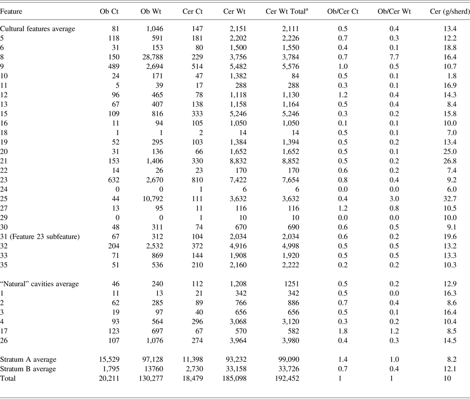
Despite the difficulties posed by mixed feature fill, we compare the size of ceramics and the ratio of obsidian to ceramics to determine the degree of preservation in different contexts (Table 1). The average size of sherds tentatively tells us about preservation in four contexts: cultural features, features that may be natural disturbances, plow zone (Stratum A), and intact sheet midden (Stratum B). Ancient features possess the largest sherds on average (14.3 g/sherd) indicating that they are the best preserved contexts. What we deemed in the field to be “natural features” were irregularly-shaped cavities into tepetate. They possess slightly smaller sherds, but they are roughly equal in size to the intact Stratum B deposits (12.9 and 12.1 g/sherd, respectively), which may reinforce our interpretation that they are natural cavities into tepetate later filled with Stratum B soils. The smallest sherds were identified in the plowzone (8.2 g/sherd), which is clearly the most disturbed context.
Obsidian (Ob) and ceramic (Cer) tabulations by feature, including count (Ct) and weight (Wt). All weights in grams.

a This category includes small pieces too fragmented to analyze. These small bits were weighed but not counted.
The mixed fill also complicates determination of feature function (except in the case of burials), but the ratio of obsidian to ceramics provides some clues (Table 1). Some features possess a very high ratio of obsidian to ceramics (cf. Stark et al. Reference Stark, Boxt, Gasco, Lauck, Balkin, Joyce, King, Knight, Kruger, Levine, Lesure, Mendelsohn, Navarro-Castillo, Neff, Ohnersorgen, Pool, Raab, Rosenswig, Venter, Voorhies, Williams and Workinger2016). Feature 8 and Feature 25 possess obsidian macronodules (compare obsidian-to-ceramic weight), which were stored likely toward the end of the site's occupation and left behind when abandoned. Features 12, 15, 27, and 31 all possess a very high count of obsidian to ceramics, which indicates that their fill may contain lithic debris from informal tool making activities.
DATING ALTICA
Dates for the site of Altica comes from two primary sources: ceramic style and radiocarbon dates. Ceramics at the site were rather poorly preserved, but they provide us with an initial idea about the age of Altica relative to other sites in the Basin of Mexico. We note that a detailed ceramic analysis undertaken by Carballo and Cabrera, with contributions by Robertson, is forthcoming. The suite of ceramic types recovered at Altica includes burnished black or brown ware, white-slipped incised ceramics (commonly with grater and double-line-break motifs), and red-on-natural pottery, mostly executed on open flat-based dishes. The assemblage as a whole fits well within the Manantial phase of the Basin of Mexico sequence, with some Tetelpan and early Zacatenco phase ceramics also present. Post-Manantial ceramics share similar motifs, but they tend to be executed with rounded bases and convex-curved or composite-silhouette walls. Red-painted decoration over a white slip, short-walled composite-silhouette forms, and serving wares with supports grow in proportion relative to incision during the late Zacatenco phase. We have almost none of those late types, emphasizing the earlier date of the site. Figurines are predominantly Type C, with only a few examples of the earlier types, including a Pahuacan head (Niederberger Reference Niederberger1976; Ochoa Reference Ochoa Castillo, Carrión and Cook2005), though we point out that we have only a small number of diagnostic figurine parts (n = 20 heads; 214 fragments total).
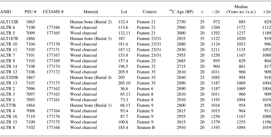
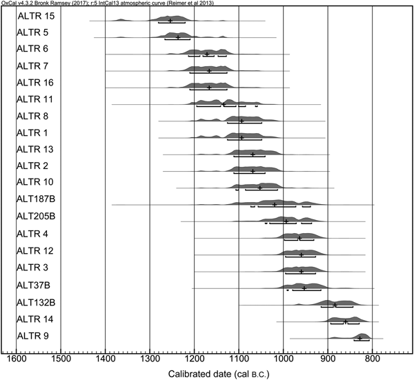
Radiocarbon dates from Altica appear in Table 2 (sorted by feature) and Figure 9 (sorted by date). We ran 16 dates on wood charcoal and another four from human bone in burials. All 20 dates for Altica fell within the range of 1281–808 cal b.c. (1σ) and 1379–804 cal b.c. (2σ). Unfortunately, all dates come from mixed fill or human bone within features. We sampled multiple pieces of wood charcoal from certain pits and the single-feature date range for them spans 300–60 years. We accept the most recent date as the terminus ante quem, but all dates are generally useful for situating the human activity on the landform. Given the brief range of dates and their continuous distribution, we do not find any of them to be so impossibly old that they would predate human activity at the site. A small number of earlier style ceramics indicate some human presence there before the late Manantial occupation. The most intensive use of Altica, however, lasted as few as 200 years between about 1025–825 cal b.c., which is almost exactly the time range attributed by Sanders to the Altica phase.
Radiocarbon dates on wood charcoal and human remains, sorted by feature sampled.

Radiocarbon dates arranged from oldest (top) to youngest (bottom). Image by Stoner.

The local Altica phase that Sanders (Reference Sanders1994; Sanders et al. Reference Sanders, West, Fletcher and Marino1975) defined based on surface materials ranged from 900–700 b.c. (1000–850 cal b.c.). Tolstoy (Reference Tolstoy and Taylor1978; Boksenbaum et al. Reference Boksenbaum, Tolstoy, Harbottle, Kimberlin and Neivens1987), upon viewing the ceramics from surface collections, was the first to indicate that Altica likely possessed a Manantial phase occupation. Tolstoy originally condensed the Manantial phase into a 50-year range between 1000–950 b.c., which he calibrated using a Seuss curve to 1300–1150 cal b.c. We recalibrated all dates for this study using the IntCal 13 curve in OxCal (Reimer et al. Reference Reimer, Bard, Bayliss, Beck, Blackwell, Bronk Ramsey, Buck, Cheng, Edwards, Friedrich, Grootes, Guilderson, Haflidason, Hajadas, Hatte, Heaton, Hoffmann, Hogg, Hughen, Kaiser, Kromer, Manning, Niu, Reimer, Richards, Scott, Southon, Staff, Turney and van der Plicht2013). Tolstoy's recalibrated dates for Manantial are 1150–1100 cal b.c. More researchers cite Niederberger's (Reference Niederberger1976, Reference Niederberger, Clark and Pye2000) dates, which range from 1000–800 b.c. (uncalibrated) for Manantial. We calibrate this range to 1150–900 cal b.c. (Figure 2). Niederberger later added a Tetelpan phase (900–800 cal b.c.), which captures the end of Altica's occupation. No absolute dates have yet yielded a post-Tetelpan occupation at the site, but some of the ceramics suggest there was a light occupation that remained during the early Zacatenco phase.
The discrepancy between Tolstoy (Reference Tolstoy and Taylor1978) and Niederberger (Reference Niederberger1976, Reference Niederberger, Clark and Pye2000) deserves some added attention. Niederberger's work was impeccable, but Tolstoy had a much broader suite of 14C dates to work with and excavations at many more sites. The tighter phases that he proposed are based on higher-precision correlations among material style and absolute dates. Therefore, the Bomba and El Arbolillo subphases he defined at El Arbolillo and Santa Catarina date within the Manantial-phase range defined by Niederberger, but he noted a stylistic shift at these sites, including more stiff-line geometric motifs and rounded bases that were more characteristic of the Zacatenco phase (Tolstoy et al. Reference Tolstoy, Fish, Boksenbaum, Vaughn and Smith1977; also American Museum of Natural History [AMNH] Catalog No. T657). Unfortunately, he never published a detailed ceramic chronology, something we intend to pursue in the near future using his curated collections at AMNH.
Given the range of radiocarbon dates we excavated at Altica and their associated ceramic styles, we believe that Niederberger's date range for Manantial is more appropriate for the Teotihuacan Valley. Here, we point out that there is geographic variation among the Basin ceramics at contemporaneous sites (Grove Reference Grove2007; Plunket and Uruñuela Reference Plunket and Uruñuela2012; Patricia Ochoa, personal communication 2018, 2005). Fitting discreet subphases into a linear temporal scale, allowing for no overlap in time nor variation over space, does not reflect the reality of ceramic style changes.
The 14C dates point to an older occupation during the Ayotla phase, but material indicators of it are present only in very small percentages. What little indication we have of an Ayotla phase occupation occurs in the form of differentially fired ceramics (Valle Borde Negativo), rocker stamping decoration, and several tecomate vessel forms. It is possible that earlier inhabitants at the site did not excavate pits into tepetate and all remains were thus completely destroyed by erosion, terracing, and plowing. The old 14C dates may result from initial forest clearance and burning by a small group who had their residences nearby but away from where we focused our work. It takes only a few people to clear a milpa and the few earlier style ceramics present at the site suggests that humans were present on the landform at the end of the Ayotla phase, which encompasses our earliest two radiocarbon dates. The burning of old scavenged wood could also account for the older dates, but we have no hearth features or stratified deposits to evaluate that possibility. A third alternative involves natural fires. We cannot discount this possibility, but the earliest dates fit nicely into a continuous sequence of later dates. If the area were prone to wild fires, we would expect much older dates as well.
No known sedentary villages have been identified in the Teotihuacan Valley prior to Altica. Two other sites, TF-17 and TF-8, possess white-ware ceramics, but white wares appear in the region through 400 cal b.c. Altica was therefore one of the earliest settlements representing the northward expansion of southern Basin groups (Sanders Reference Sanders1981:164). We see no in situ transition from Archaic foragers (Parry Reference Parry2001) to Manantial-phase villages, as the Teotihuacan Valley lacks initial ceramic Nevada-phase pottery and the Ayotla phase is represented by only a handful of sherds from Altica (cf. Niederberger Reference Niederberger1976). Furthermore, ceramics and figurines at Altica closely resemble those excavated at Manantial and Tetelpan-phase Tlapacoya, including rare stylistic elements such as double bowls attached in the middle with a “basket” handle and a duck appliqué atop a flat everted dish rim. Note that Altica is situated quite far away from any standing water that might attract waterfowl. Whether by migration, diffusion, or trade, we suggest that Altica developed during the Manantial phase due to close relationships with groups in the southeastern Basin of Mexico. These interactions/migrations brought a package of related cultural developments to the Teotihuacan Valley: sedentism, village life, ceramic technology, agricultural technology and crops, trade goods, and a demand for local obsidian.
PATTERNS OF LITHIC REDUCTION AND EXCHANGE
We demonstrate in several papers in this Special Section that Altica was directly or indirectly connected to many sites in the Basin of Mexico, Tlaxcala, and Puebla. Altica was a terminal node in the Formative exchange network, exemplified by the small amount of prestige goods imported from elsewhere (Storey et al. Reference Storey, Buckley and Kennett2019) and quite a few ceramics brought into the site from over 100 km away (Stoner and Nichols Reference Stoner and Nichols2019). At least seven percent of all excavated white wares have been sourced chemically and petrographically to production locations in Morelos, Puebla, and possibly from sites in the southeastern Basin of Mexico. We did not analyze the composition of all potential imports, so this figure could be even higher. In exchange for these imports, Altica likely had some role in the extraction and trade of Otumba obsidian located 10 km (17 km by foot) away. The centrality of Altica in this extractive network, however, is uncertain.
Access to the Otumba obsidian source may be a reason for the settling the Teotihuacan Valley. Supporting Tolstoy's (in Boksenbaum et al. Reference Boksenbaum, Tolstoy, Harbottle, Kimberlin and Neivens1987) earlier observation, our recent work returned an obsidian-to-ceramics ratio for the site of about 1.0 from excavated contexts (Table 1). Surface obsidian outnumbers ceramic artifacts. For obsidian to equal or exceed the number of ceramic artifacts at any Mesoamerican site is rare. In fact, a recent study on lithic commodity chains established the highest ratio of lithics to ceramics in coastal regions of Mesoamerica as 0.48 during Locona-phase Paso de la Amada (Stark et al. Reference Stark, Boxt, Gasco, Lauck, Balkin, Joyce, King, Knight, Kruger, Levine, Lesure, Mendelsohn, Navarro-Castillo, Neff, Ohnersorgen, Pool, Raab, Rosenswig, Venter, Voorhies, Williams and Workinger2016). The central highlands may have on average higher ratios than coastal areas simply due to their proximity to a number of obsidian sources.
Healan (Reference Healan2019) suggests that the large quantity of obsidian at Altica may reflect proximity to another unknown site within the Teotihuacan Valley or closer to the source that was active in the primary or secondary processing of Otumba obsidian. We did, however, find obsidian macronodules cached in two pits at the site. If Altica exported any obsidian from the site, it took the form of relatively unmodified nodules that were made into tools elsewhere. That said, Altica was not a workshop dedicated to making tools or preparing cores for export.
Johnson and Hirth (Reference Johnson and Hirth2019) examine the downstream flow of obsidian, including that from the Otumba source. They also analyzed Altica surface collections from the 1960s (Boksenbaum et al., Reference Boksenbaum, Tolstoy, Harbottle, Kimberlin and Neivens1987). Johnson and Hirth's analysis shows varied source procurement and tool production across the Basin of Mexico. We argue that both Healan and Johnson and Hirth's contributions support an interpretation that obsidian procurement and exchange was becoming more regimented, with different reduction tasks performed at relatively specialized sites in the region.
At Altica, the consumption of obsidian materials and tools processed elsewhere points to the existence of primary and secondary workshops somewhere in the Teotihuacan Valley. On one hand, the Altica obsidian consumption profile indirectly implies a compartmentalized system of obsidian processing in the northeast subregion of the Basin with task-specific reduction sites emerging to facilitate extraction and movement of the material to end consumers. On the other hand, Altica possesses many imports from both long distances and from within the Basin of Mexico. Altica was exporting something, and the strongest evidence currently available points to obsidian macronodules.
Otumba was one of the most traded obsidians in highland Mexico during the Early and Middle Formative periods (for a summary, see Stoner et al. Reference Stoner, Nichols, Alex and Crider2015) and was also consumed in considerable amounts by some sites in the lowlands (Ebert Reference Ebert2013; Hirth et al. Reference Hirth, Cyphers, Cobean, De León and Glascock2013). Along with jade, shell, iron ore, and other materials, Otumba obsidian was among the earliest goods traded over long distances. This early trade linked a broad area through a system of prestige exchange. Exchange systems of prestige goods are initiated by status seekers or emerging elites. Display of exotic goods to others in the local group demonstrated the capabilities of the elites, and the goods themselves could be gifted to other key players in the local system. This is an individualized strategy to generate social capital focused on resources external to the local system (Blanton and Fargher Reference Blanton and Fargher2009; Carballo and Feinman Reference Carballo and Feinman2016).
We (Stoner et al. Reference Stoner, Nichols, Alex and Crider2015) believe that obsidian acted as a bulk prestige good during the Early Formative (Clark Reference Clark, Johnson and Morrow1987). Later during the Middle Formative, however, obsidian exchange systems became more efficient thanks to trade-oriented, “gateway” sites like Chalcatzingo and Coapexco (Johnson and Hirth Reference Johnson and Hirth2019) and more specialized extraction networks established closer to the sources. Obsidian became a common utilitarian commodity after 1000 cal b.c. and lost any prestige value it may have had during earlier time periods. Neff (Reference Neff and Martinón-Torres2014) recently presented a similar argument with regard to long-distance ceramic trade during the same time frame.
COMPOSITIONAL SOURCING OF CERAMICS
To permit future studies of ceramic exchange in Formative central Mexico, we collected a large sample of ceramics for chemical analysis. The majority of the ceramic chemical database at the University of Missouri Research Reactor (MURR) comprises fine-paste Postclassic ceramics. Stoner (Reference Stoner2016) found based on laser ablation inductively coupled plasma mass spectrometry and petrography that the Early and Middle Formative ceramics contain much more and larger grains of volcanic aplastics. The aplastic fraction, as opposed to the clay fraction, tends to have more influence in Formative provenance analysis, so comparisons to Postclassic reference groups could lead to erroneous source assignments. With our sample, we aim to create local reference groups for Formative ceramics in central Mexico, but we have identified several trade wares as well. With the help of colleagues in neighboring regions, the sample has expanded to Hidalgo, Tlaxcala, Puebla, Morelos, and Toluca. We encourage more Formative ceramic analyses for other regions of Mesoamerica as well, and have begun to work with archaeologists in the Soconusco and Tehuacán toward this end. We have also sampled ceramics from MacNeish's and Ekholm's collections in Panúco housed at the AMNH.
In short, the compositional ceramic data show that all sampled localities made most of their own pottery, including those that bear pan-Mesoamerican styles and symbols that typify early horizons. Stoner and Nichols (Reference Stoner and Nichols2019) argue that trade of at least a minority of ceramics (or the migration of the potter) is necessary to foster the spread of interregional style horizons. During the Early and Middle Formative, pottery styles display the greatest coherence across Mesoamerica compared to any other time period. We identify long-distance imports during what we call (following Rosenswig [Reference Rosenswig2010]) Horizon I (1400–1000 cal b.c.), but mostly of the visibly nonlocal fine-paste Xochiltepec White and Atoyac Fine Gray ceramics from the southern Gulf lowlands and possibly Oaxaca (though not yet definitively proven; Blomster et al. Reference Blomster, Neff and Glascock2005; Herrera et al. Reference Herrera, Neff and Glascock1999). Coarse-paste ceramics with carved Olmec designs are almost all locally-made replicas of styles recently introduced from the outside. Tolstoy (Reference Tolstoy and Diehl1989) notes that ceramics emulating Gulf Olmec styles are found among all social statuses at Tlatilco. Possession of these symbols is therefore more an indicator of social identity and cultural affiliation than prestige and social differentiation.
Sources of long-distance pottery trade in the Basin of Mexico shift from the Gulf Coast during the Early Formative (Horizon I) to a more proximate source likely in southwestern Puebla during the late Early and early Middle Formative. We define this as Horizon IIa and date it to around 1150–800 cal b.c. (overlap is intentional) to refer to the emergence of the white-ware horizon in the Basin of Mexico and a corresponding decrease of direct emulation of contemporaneous Gulf designs (Blomster et al. Reference Blomster, Neff and Glascock2005; Cyphers Reference Cyphers and Grove1987; Herrera et al. Reference Herrera, Neff and Glascock1999; Niederberger Reference Niederberger1976). We also identify a trend of increasing intraregional trade patterns that provide a layer of cultural transmission beneath the broad-scale exchanges, integrating neighboring communities not directly linked into networks of pan-Mesoamerican trade or migration. By the latter part of the Middle Formative, which we call Horizon IIb (900–600 cal b.c.; again, overlap intentional) interregional exchanges greatly decline. These style horizons break into regional ceramic traditions by the Late Formative. We argue that visibly distinctive regional traditions that divide Late Formative Mesoamerica result from a process of cultural divergence that began centuries earlier around 800 cal b.c. At that time, interregional exchange of pottery decreases and becomes more restricted geographically. Given that ceramics provided one of the most expressive cultural media of the time, the collapse of interregional ceramic's trade left the slow change of vertical (generational) transmission as the primary mechanism of cultural inheritance (Eerkens and Lipo Reference Eerkens and Lipo2005; Shennan Reference Shennan, Preucel and Hodder1994). Regional cultural styles began to drift the way language does in the formation of regional dialects.
DIET, HEALTH, AND STATUS DIFFERENTIATION?
McClung de Tapia and colleagues (Reference McClung de Tapia, Acosta-Ochoa, Martínez-Yrizar, Adriano-Morán, Cruz-Palma and Chaparro-Rueda2019) present the results of macrobotanical, phytolith, and pollen analysis. Macrobotanical remains come from floatation, while phytoliths, pollen, and starch grains were “washed” from stone grinding implements. As a whole, the botanical remains show a reliance on maize, beans, and chili. Yam, sweet potato, and possibly manioc were also identified, all of which have never been previously identified in the Teotihuacan Valley. These are lowland root crops that would likely have been brought in through interregional exchange. Other plants identified include Chenopodium, amaranth, agave (maguey), and several others in minor proportions.
Whether or not the botanical profile identified at Altica represents an agriculture-based diet is debatable. Some of these plants emerged in their domesticated form thousands of years before people occupied Altica, yet no Mesoamerican groups fully shifted to a reliance on agriculture until at least 1000 cal b.c. (Arnold Reference Arnold2009; Killion Reference Killion2013; McClung et al. Reference McClung de Tapia, Serra Puche and Limn de Dyer1986; Piperno Reference Piperno2011; Rosenswig et al. Reference Rosenswig, VanDerwarker, Culleton and Kennett2015; Sanders et al. Reference Sanders, Parsons and Santley1979; VanDerwarker Reference VanDerwarker2006). Domestication of tropical plants added diversity to a mixed subsistence economy and reduced risk by making maize and other weedy species more predictable and concentrated over space (see discussion in Nichols Reference Nichols2015:411–412). These new foods permitted foragers to dominate Mesoamerica before it became Mesoamerica. Even groups on the cusp of becoming sedentary Mesoamerican villages continued to use maize more for social capital through feasts and likely added fermented beverages to the process (Clark and Blake Reference Clark, Blake, Brumfiel and Fox1994; Hayden Reference Hayden, Price and Feinman1995). Something changed at 1000 cal b.c. across Mesoamerica, which is around the peak occupation of Altica. In addition to the botanical remains discussed above, we see evidence of increased reliance on maize at Altica along three lines: technology, skeletal health, and isotopic signatures.
While we have not yet formally analyzed the grinding tools at the site, many grinding slabs and manos were identified. It is unclear when the first formal metates appear in central Mexico. Niederberger (Reference Niederberger, Clark and Pye2000) sees grinding implements at Zohapilco/Tlapacoya by about 2000 b.c., including grinding slabs with troughs created by wear from use of the so-called “short mano.” None of our metates display this trough pattern of wear. One grinding slab, made of a pink rhyolite/dacite porphyry (not available in the immediate environment surrounding the site), was buried with an elderly woman approximately aged 60 years who died around 950 cal b.c. Though broken, it appears to have been a formal metate, lacking supports but with refined edges and squared corners. The other grinding stones typically lack formal rectilinear shapes and supports of later metates, but they are relatively ubiquitous on the site. Conversely, animal bones are almost absent. While lack of preserved garbage dumps confounds any argument, the lack of animal bones may support a greater reliance on plants. Preservation is not likely the primary explanation for the dearth of animal bones, as human bones, typically less resistant to depositional decomposition than animal bone, was found preserved in pits. The alternative is that animal bones were discarded on the surface and had been obliterated along with the top of the site.
Four pits held burials. We do not know if Alticans interred all their dead into deep pits, or if these individuals received special treatment. All four individuals may have merited higher status than the general population, and others may have received shallower interments now destroyed.
Two of the burials are females over age 40. Both appear to be either secondary burials or seated burials that had shifted considerably after deposition. Burial 1 (1016–858 cal b.c., 2-sigma range) is the aforementioned elderly woman interred with a large metate made of a pink rhyolite/dacite porphyry. Burial 4 (1085–918 cal b.c., 2-sigma range) also had metate fragments in the pit with her, but it is unclear if these were offerings or general fill. No other grave offerings were present with either female.
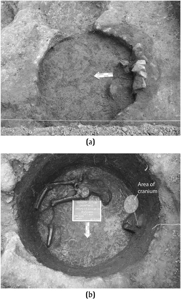
The other two burials were males who were interred in quite different fashions. Burial 2 (972–829 cal b.c., 2-sigma range) was a young male in his 20s (Figure 10). He was buried in a disrespectful position, face down. His lower right leg was disarticulated from the rest of his body. Associated with the burial was a very large, thick-walled, red-painted basin. The vessel is almost complete, but broken, perhaps intentionally, and the pieces thrown in on top of the burial. Though the vessel visually appears to have a typical paste recipe represented by other ceramics at the site, its form is unique. The base is nearly 3 cm thick and heavily pitted from use. The final treatment of this burial involved sealing him in the cylindrical pit with a large pile of volcanic rock. The locals feared or despised this individual, and precautions were taken to ensure he could not harm local residents in life or death. Further, strontium isotopes demonstrate that he grew up in an older geological terrane, likely the same terrane in southwest Puebla as the white-ware imports identified at Altica (Stoner and Nichols Reference Stoner and Nichols2019; cf. Alex et al. Reference Alex, Nichols and Glascock2012). Trade gone wrong?
Feature 21 at (a) the beginning and (b) end of excavation. Burial 2 shown at the bottom, buried face down with a detached lower right leg. The top photo shows the andesite rocks that were pushed into the pit. These rocks go all the way down to the bottom and directly cover the burial. Photographs by Stoner.

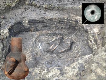
Burial 3 (1122–919 cal b.c., 2-sigma range) was interred in the only rectangular pit identified at Altica (Figure 11). This middle-aged male possessed three grave offerings: an undecorated cylindrical vessel; a tlacuache (opossum) effigy bottle reminiscent of the “Tlatilco culture”; and a large jadeite bead. The burial itself was in a flexed position on his right side, situated within a small rectangular basin within the larger rectangular pit. The possibility was considered that this was a burial within the floor of a small household, but the larger pit measures 1.8 × 1.6 m, which is very small compared to the better-known house basins excavated at Coapexco (Tolstoy Reference Tolstoy and Diehl1989). We think that the pit was excavated specifically to receive this burial. It is the only feature excavated at Altica with distinguishable soil layers. The burial was carefully covered with a layer mixed black-and-white soil that is a combination of degraded tepetate and the dark, silty clay of Stratum B. Field excavators called this soil mixture “marble cake” because of its appearance. This male clearly held a higher status based on burial treatment and grave offerings.
Burial 3 in nested rectangular features. This individual was of comparatively high status and was interred with three grave goods, including a tlacuache (opossum) effigy bottle, a cylindrical vase, and a jadeite bead. Photograph by Stoner.

All of the burials present paleopathological indicators of morbidity during life. Periosteal lesions on skeletal remains from all burials indicate nonspecific bacterial infections. Cribra orbitalia is found on all burials and porotic hyperostosis on burials 1–3 likely index nutritional stress during childhood. The δ13C analysis demonstrates reliance on C4 plants, such as maize. Stable nitrogen ratios show primarily consumption of terrestrial animals.
Grinding tools, botanical remains, health and morbidity, and isotope data all suggest that the inhabitants of Altica relied significantly on agriculture, particularly the cultivation of maize. They were part of the first generation in the Basin of Mexico to make this subsistence shift. This is evident by the relative abundance of coarsely made grinding tools on site, and especially those associated with female burials 1 and 4. These are some of the earliest metates in Mesoamerica, a point emphasized by the crude form they take. Given the transitional nature of Altica subsistence practices, we would expect some struggles leading ultimately to the childhood nutritional stresses mentioned above.
SUMMARY: ALTICA AS A SIGN OF THE TIMES
Altica is a small village in the Teotihuacan Valley that reflects broad-scale cultural, economic, and political changes across Mesoamerica. We see no in situ shift from foraging groups (Parry Reference Parry2001) to sedentary villages in the valley. The site, along with others in the northern Basin, was therefore likely settled by groups that fissioned off of larger sites in the southern Basin at the end of the Ayotla phase (Sanders et al. Reference Sanders, Parsons and Santley1979:95–96). Based on ceramic similarities and patterns of intraregional ceramic trade, we argue that the Teotihuacan Valley was affiliated more with sites like Tlapacoya and Temamatla in the southeastern Basin (Niederberger Reference Niederberger1976; Ramírez Sánchez et al. Reference Ramírez Sánchez, Gámez and González2000) than Tlatilco or El Arbolillo in the west (Ochoa Reference Ochoa Castillo, Carrión and Cook2005; Tolstoy Reference Tolstoy1984).
The lack of Olmec-inspired carved ceramics at Altica marks it as part of the first generation in the Basin of Mexico that moved away from replication of Gulf Coast designs. The major occupation at Altica is late Manantial, so it is clear that Olmec deculturation took place at some sites before Tetelpan, the phase that Neiderberger (Reference Niederberger, Clark and Pye2000) argued to mark the decline of Olmec symbolism. Though some lingering Olmec-inspired designs are still found at Tlapacoya during this time frame, the techniques of incision greatly change and remnants of the previous “Olmec Horizon” are likely inherited from earlier generations without direct sustained replication of Gulf styles. At Zohapilco/Tlapacoya, there is a tremendous stylistic shift seen among ceramics and figurines across the Ayotla–Manantial-phase transition that points to a rupture in whatever mechanism fostered the spread of Olmec designs to the Basin of Mexico (Niederberger Reference Niederberger1976). Moreover, double-line-break white-ware bowls appear in the Basin of Mexico at least 150 years prior to their appearance in the Gulf lowlands. These two points indicate that direct and intensive cultural exchanges between the two regions ceased for a time at the end of the Ayotla phase, likely to be replaced by more indirect down-the-line interactions in the Middle Formative. Over the next 1000 years, the Basin of Mexico and the southern Gulf lowlands diverged culturally, with some exceptions.
This shift is also seen in the trade of culturally sensitive ceramics. Even during the Ayotla phase, when the Gulf Olmec were a source of inspiration for Horizon I ceramics, almost all such designs in the Basin of Mexico were locally produced. Perhaps migration of people from the coast (or from the Basin to the coast and back again) will turn out to be a common phenomenon once larger burial samples are analyzed via isotope and aDNA analyses. Potters trained in the Gulf Coast ceramic chaîne opératoire were likely present at sites like Tlatilco, Tlapacoya, and Coapexco.
Exchange of most types of goods and materials intensified into the early Middle Formative. First, though we do not evaluate it here, we predict that future composition studies of double-line-break white wares in regions like Tehuacán, the Valley of Oaxaca, the Gulf Coast, Guerrero, and the Soconusco may reveal imports from central Mexico. MacNeish and colleagues (Reference MacNeish, Peterson and Flannery1970) and Flannery and Marcus (Reference Flannery and Marcus1994) identify suspected Basin of Mexico imports among assemblages in the Tehuacán Valley and the Valley of Oaxaca, respectively. The lion's share of early Mesoamerica sourcing studies have focused on the dissemination of the Olmec style, but a new focus on the subsequent white-ware horizon is equally important to understand (1) how the Olmec style lost its popularity; and (2) how Mesoamerica as a whole changed to foster even more intensive and efficient exchange systems with more decentralized sources of inspiration.
The obsidian industry at Altica is also indicative of an effort to more efficiently extract the raw material through an organic system of specialized sites established in the Teotihuacan Valley. That Altica is not making tools or preparing cores for export (Healan Reference Healan2019) was a bit surprising given the relatively high ratio of lithics to ceramics (cf. Stark et al. Reference Stark, Boxt, Gasco, Lauck, Balkin, Joyce, King, Knight, Kruger, Levine, Lesure, Mendelsohn, Navarro-Castillo, Neff, Ohnersorgen, Pool, Raab, Rosenswig, Venter, Voorhies, Williams and Workinger2016). This discrepancy indicates that another site in the Teotihuacan Valley (perhaps near Altica or closer to the source) was processing obsidian for exchange. Altica was potentially consuming the waste material of this site (Healan Reference Healan2019). The two caches of relatively unmodified nodules found in pits at Altica, however, raises the likelihood of raw material export from the site. Altica was importing a variety of things (pottery, foreign obsidian, jade, and lowland root crops) and must have had something of value to trade in return.
The increasing systematization of obsidian extraction and tool production is also seen through the variability in source material and processing tasks at other sites in the region, some of which functioned as gateways that brought in nonlocal materials and likely shipped them out as well (Johnson and Hirth Reference Johnson and Hirth2019). Eventually, during the Middle Formative, the interregional obsidian trade functioned on a level of domestic provisioning (Hirth et al. Reference Hirth, Cyphers, Cobean, De León and Glascock2013). It likely followed the same prestige networks previously established, but ultimately operated outside an elite network during the Middle Formative. Of course, exotic and rare materials and goods, like jade axes and beads, were still traded and perhaps also intensified by the general improvements to interregional trade networks.
Altica represents a filling-out of settlement systems that took place in all regions across Mesoamerica at the beginning of the Middle Formative. This process began with more intensive reliance on agriculture at permanently-settled villages. Altica is the earliest site in the Teotihuacan Valley to exhibit a settled agricultural lifestyle. The trial-and-error learning process for the transition from forager to food producer is evident through indicators of childhood nutritional stress (Storey et al. Reference Storey, Buckley and Kennett2019) and, ultimately, through the maladaptive behavior of forest clearance without erosion prevention measures that eventually made agriculture at Altica unsustainable.
The filling-out of the settled landscape also speaks of rising regional population levels increasingly becoming interlinked through social, economic, and political relationships. During the occupation of Altica, there were no known urban/rural patterns that featured a political center and a dependent hinterland (Sanders et al. Reference Sanders, Parsons and Santley1979). Niederberger (Reference Niederberger, Clark and Pye2000) refers to Tlapacoya and Tlatilco as “regional centers” but they were likely ritual foci rather than political/administrative capitals. Center/hinterland patterns became more demarcated during the Middle Formative to Late Formative transition (Sanders et al. Reference Sanders, Parsons and Santley1979).
Increased population densities, interconnectivity of sites, and greater political influence of individuals at larger sites in the region passed a critical threshold that enabled the mobilization of labor for construction of the first monumental architecture (Niederberger Reference Niederberger, Clark and Pye2000; Serra Puche and Ramírez Sánchez Reference Serra Puche and Ramírez Sánchez2001). At first, these architectural projects were not nearly as monumental as their contemporaries on the Pacific (Joyce Reference Joyce2004; Love Reference Love2002) or Gulf coasts (González Lauck Reference González Lauck1988; Heizer and Drucker Reference Heizer and Drucker1968; Pool Reference Pool, Arnold and Pool2008). The earliest securely dated monumental structure in the Basin of Mexico is a ballcourt at Temamatla (Serra Puche and Ramírez Sánchez Reference Serra Puche and Ramírez Sánchez2001), which likely had a communal ritual benefit without necessarily producing a centralized power structure. At Tlapacoya, a large platform was bulldozed for construction fill, so its temporal placement is insecure (Niederberger Reference Niederberger, Clark and Pye2000). Another cooperative labor project that began during the Middle Formative involved community enhancement of irrigation works, a common-pool resource (Nichols and Stoner Reference Nichols and Stoner2019).
In general, the Basin of Mexico transitioned from an externally focused prestige network of long-distance exchanges during the Early and early Middle Formative periods to a more internally focused collective system as the Formative period passed. Altica is perched in time at the zenith of this transition. The site heavily emphasized an external economy. Around the time of its abandonment and over the next few centuries, however, the long-distance focus of Basin groups inverted to emphasize intraregional trade development, consolidating settlement hierarchies, and creation of public goods. Over the centuries leading into the Late Formative, the Basin as a whole had become much more corporately organized at the expense of the long-distance networks of earlier time periods. The stage was set for the region's first cities and the dawn of the Teotihuacan era.
RESUMEN
Esta sección especial de Ancient Mesoamerica tiene objetivos múltiples concernientes al “Proyecto Altica,” realizado por Nichols y Stoner en el Valle de Teotihuacan, y para entender la Mesoamérica temprana en general. El primero es el de reavivar el interés en la investigación orientada a problemáticas en los periodos formativo temprano y medio en la Cuenca de México, uno de los crisoles donde se formó Mesoamérica como una región cultural. Ahí grupos participaron en horizontes de estilo pan-Mesoamericano durante los periodos formativo temprano y Medio, proporcionando una base cultural compartida y estableciendo redes tempranas para la integración interregional. Para el formativo tardío, los horizontes de estilo se habían segmentado dando lugar a un paisaje cultural más balcanizado a medida que las primeras ciudades Mesoamericanas giraron su atención hacia una consolidación política y económica intrarregional, permitiendo en última instancia la expansión posterior de Monte Albán y Teotihuacan.
El segundo objetivo de esta Sección Especial es la de reportar los hallazgos de nuestra investigación multidisciplinaria en Altica, la temporización de este asentamiento en relación a los patrones más amplios de Mesoamérica, y su papel en los sistemas de intercambio en el Formativo. Altica fue descubierto inicialmente en el recorrido de superficie del Teotihuacan Valley Project en la década de los sesentas. Posteriormente, durante un proyecto piloto emprendido por Nichols y su antigua estudiante Bridgett Alex, llevaron a cabo análisis de composición de una muestra de cerámica de las colecciones de superficie de Sanders para encontrar un grupo considerable de loza blanca importada. Este sitio también había sido identificado como un punto significativo en la distribución de obsidiana de Otumba durante esos periodos tempranos. Nuestro interés fue estimulado por el interés de entender el papel de Altica en las redes de intercambio tempranas, por lo que nos abocamos a establecer un programa de investigación en el sitio.
Como resultado del Proyecto Altica, podemos demostrar su supremacía como la aldea más temprana conocida en el Valle de Teotihuacan, iniciando una larga historia de ocupación continua que llevó a la fundación de Teotihuacan en el fondo del valle. Sitios como Altica que se han salvado del crecimiento urbano moderno representan oportunidades para investigar los procesos iniciales de la evolución cultural. Los elementos arqueológicos sobrevivieron a la erosión y arado profundo y presentan una rara oportunidad para excavar depósitos culturales intactos. Los entierros recuperados en esas fosas son analizados para conocer su dieta, salud, origen geográfico, y afinidad biológica. Los restos botánicos revelan una subsistencia económica en transición. Los análisis de la cerámica y la lítica proporcionan introspecciones de como Altica encaja dentro de los sistemas regionales culturales y económicos más amplios.
ACKNOWLEDGMENTS
We thank the people of the Ejido of San Francisco Tlaltica for granting us permission to conduct the research. Particular thanks go to the individual landowners that permitted us to work on their lands. We also thank the people who worked on the project: Oralia Cabrera, Ivonne Pérez, Luz Escobedo, Nadia Johnson, Andrés Mejía, Alex Jurado, Eric Jurado, Aaron Watanabe, Vicente Aguirre, Refugio Aguilar Espinoza, Maximiliano Chávez, Brisio Ramos, Alejandro Aguilar, Faustino Aguilar, Ezequiel Aguilar, Antonio de Jesús López, Jovanis Zuluaga Vite, Rodrigo Zuluaga Charaga, and Francisco Chávez. Permission for the research was given by the Consejo de Arqueología, Instituto Nacional de Antropología e Historia, Centro del INAH Estado de México, and Municipio de Tepetlaoxtoc. We appreciate the assistance of Alejandro Sarabia (INAH-Teotihuacan) and the Arizona State University (ASU) Teotihuacan Research Center. We thank Jennifer Carballo, Robert Cobean, Luis Gamboa, Richard Lesure, James Neely, Patricia Plunket, Mari Carmen Serra Puche, Yoko Sugiura, Paul Tolstoy, and Gabriela Uruñuela for permission to analyze samples of ceramics they collected. Funding was provided by the National Geographic Society No. 9432-14, the National Science Foundation NSF No. 1424132-Nichols (Dartmouth), NSF No. 1451425-Stoner (Arkansas), the Claire Garber Goodman Fund-Dartmouth, Rockefeller Center for the Social Sciences Urban Studies Grant-Dartmouth, Dickey Center for International Understanding-Dartmouth, Neukom Center for Computational Sciences-Dartmouth, and the William J. Bryant 1925 Professor of Anthropology-Dartmouth. Artifacts from the Altica excavations and survey are curated at the ASU-Teotihuacan Research Laboratory in San Juan Teotihuacán, Mexico, along with copies of excavation and survey records that are also on file with the project principal investigators, Nichols and Stoner at Dartmouth and the University of Arkansas, along with other project data files.