Introduction
It has long been recognised that two-dimensional map measurement underestimated the actual length of the Antonine Wall on the ground.Footnote 1 The LiDAR survey of the Wall undertaken in 2010 allowed the topographic undulations along its line to be taken into account for the first time and resulted in a suggested increase in the length of the monument from 60.24 km, on the basis of two-dimensional map measurement, to 62.03 km, based on three-dimensional measurements.Footnote 2 Subsequent adjustments to our understanding of the line at various locations have increased that figure to 62.78 km.Footnote 3 Given the character of the measurement methods that were employed at the time, which were ground-based and so variations in elevation would have been incorporated,Footnote 4 this figure provides a more accurate estimate of the length of the Wall as it was perceived and recorded by the Roman legions.
We are extremely fortunate that the Antonine Wall was provided with a series of monumental building inscriptions that record in quite specific detail the division of work among the three legions responsible for its construction. Though they fall within a general tradition of military building inscriptions, these distance slabs, as they are traditionally known, are without direct parallel on any other Roman linear frontier.Footnote 5 Some 18 have come down to us, one of which survives only as a number of plaster casts after the original was destroyed in a fire in 1871, but two more may reasonably be assumed (Table 1). The probable nineteenth example from Arniebog is fragmentary. No inscription survives on it, but the style and dimensions of the sculptured stone are highly reminiscent of other distance slabs and it is generally accepted as such.Footnote 6 A long-lost stone from Ferrydyke near Old Kilpatrick, noted by Maitland in the mid-eighteenth century, probably provides a twentieth example, but the inscription was no longer intelligible by that time after use for many years as a threshold stone.Footnote 7 Macdonald dismissed Maitland’s identification on the grounds that it would have provided superfluous duplication, but Keppie notes the similarity in form to the slab of legio XX from Castlehill and we now know of other duplicates, such as the two slabs also of legio XX from Hutcheson Hill.Footnote 8 Most of the distance slabs were recovered during agricultural activity, the earliest from the late sixteenth century, and the vast majority are complete or very nearly so.
The recorded dates of discovery and provenance of the distance slabs, listed in estimated geographical order from east to west.

* That only some 25–30% of the slab was recovered suggests that it may have been moved, presumably for agricultural purposes, in antiquity.
Because of the circumstances and generally early dates of their discovery, the provenance of most of the slabs can be quite imprecise (Table 1). Nonetheless, two facts are apparent. Firstly, where accounts of their original discovery survive, the stones were found consistently on or very close to the line of the Wall whose construction they directly record.Footnote 9 Secondly, there is a clear bias in their known geographical distribution (Fig. 1), with 11 of the slabs coming from the most westerly c. 7 km of the Wall. However, this bias is simply a reflection of the greater number of slabs erected there as a result of the subdivision into six smaller legionary sections of the last sector to be built. It is widely accepted that this further subdivision of the work took place in order to complete the building process more rapidly after a period of delay.Footnote 10 In these westerly examples the distances were recorded in feet (pedes) (Table 2), rather than in paces (passus) (e.g. Table 3). By contrast with the large number of stones from the most westerly 7 km, only two slabs have been recorded from the c. 25 km between Bridgeness, at the eastern end of the Wall, and Arniebog towards its centre.
Map of the find spots of all distance slabs where sufficiently detailed locational information is available. (© Crown Copyright and Database right 2024. Ordnance Survey licence number AC0000807262).

A comparison of the three-dimensional lengths of the six most westerly building sections of the Wall with the lengths recorded on the relevant distance slabs, expressed in both pedes Monetales and pedes Drusiani.

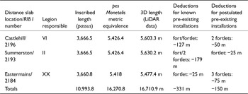
A comparison between the three-dimensional lengths of the three building sectors from Castlehill to Eastermains and the lengths recorded on the relevant distance slabs.

The LiDAR data allow us to make direct correlations between the detailed records on the distance slabs and the reality of the construction process on the ground. However, this correlation is complicated by some uncertainty about the length of the Roman foot being used, as two different standards seem to have been employed in the north-western provinces of the Empire: the pes Monetalis (equivalent to 0.296 m) and the pes Drusianus (equivalent to 0.333 m; see also ‘Measurement precision’, below).Footnote 11 While differentiating between the use of these two measures may be difficult statistically when applied to buildings, as Millett rightly pointed out,Footnote 12 the differences become significant, and so more readily recognisable, when dealing with the longer distances under consideration here. For example, two Roman miles would equate to 2,960 m if using the pes Monetalis, but to 3,330 m if using the pes Drusianus. An earlier attempt by the second author to address the issue of which unit of measurement had been utilised on the Antonine Wall concluded that it was most likely to have been the pes Drusianus.Footnote 13 However, a number of errors and incorrect assumptions have subsequently been recognised which have cast serious doubt on this conclusionFootnote 14 and prompted the reconsideration presented here.
Measurement precision
It should be noted that the precision of the measurements used in this paper is dependent on a number of factors. There is, for example, some slight level of uncertainty about the precise metric equivalent of the Roman foot. According to Hulsch, the extant examples of the pes Monetalis reveal variations between 0.291 m and 0.297 m, but he suggests an average of 0.2957 m.Footnote 15 This is the widely accepted figure which has been used in this paper, rounded to three decimal places. However, over a distance of 4,652 paces, as recorded on the Bridgeness slab (see ‘From Bridgeness to the River Avon’, below), even that rounding makes a difference of some 7 m to the resulting metric conversion. According to Hyginus, the length of the pes Drusianus is one eighth larger than the pes Monetalis, which would produce a figure of 0.3327 m.Footnote 16 This is variably rounded to 0.333 m or 0.332 m.Footnote 17 The former has been used in this paper in accordance with standard mathematical rules of rounding to the nearest integer.
Other factors that need to be taken into account include the accuracy of the LiDAR measurements as detailed in the original survey report,Footnote 18 the algorithms used to produce the Digital Terrain Model from the LiDAR point cloudFootnote 19 and the accuracy of our current knowledge of the precise line that was followed by the Wall.Footnote 20 To check the accuracy of the measurements derived from HES-procured LiDAR data, the calculations were also run against both the Phase 2 and Phase 5 Scottish Government LiDAR data where the coverage was available.Footnote 21 In the section between Hag Knowe and Watling Lodge a significant discrepancy was identified, with the HES-derived data delivering a shorter measurement than the two Scottish Government datasets. As the two Scottish Government datasets produced comparable results and the HES data were the exception, the Scottish Government Phase 5 data were used for this section. In all other sections the measurements from the three LiDAR datasets produced consistent results. It should also be noted that the measurements used follow the modern ground surface that will differ in places from the Roman ground surface. Therefore, they can only ever represent an approximation of the terrain at the time of the Roman occupation of Scotland.
From Castlehill to the Clyde
That the sector of the Antonine Wall from Castlehill to the Clyde by Old Kilpatrick was the last to be constructed is evident not only from the change in the unit of measurement used on the distance slabs (see ‘Introduction’, above), but from the stratigraphic relationship between the Wall rampart and the forts and fortlets that it linked together. Thus, the fort at Old Kilpatrick and the fortlets at Cleddans and Duntocher were originally built as freestanding structures, the latter even being replaced by a small fort before the Wall rampart finally came to be attached.Footnote 22
The six short sections between Castlehill and the Clyde were divided equally among the three legions, each being allocated two sections totalling just under or just over 3,400 feet (Table 2). Distance slabs survive for each of these sections and there are even some duplicates, confirming that each section would have been marked by at least two slabs at each end (Fig. 2).Footnote 23 We have a precise record from the 1st edition Ordnance Survey mapping of the discovery location of the most easterly of this group, which was found on the southern lip of the ditch some 145 m southwest of the fort at Castlehill (Table 1). We also now know to within a few metres the point at which the Wall reached the north bank of the Clyde at Ferrydyke to the west of Old Kilpatrick because of the recovery there of two distance slabs. Only one of these (RIB I 2208) survives to provide a record of the distance constructed, but the other (RIB I 2207) gives us more precise locational information (Table 1). A small settlement, named Ferry, is visible on Roy’s Military Survey of Scotland to the west of Old Kilpatrick, which is represented on the 1st edition Ordnance Survey map by two cottages.Footnote 24 They sit within an enclosure named Ferrydyke, whose southern side had been truncated by the construction of the Forth Clyde canal (Fig. 3). This corresponds well with location of the lost distance slab described by Maitland (see ‘Introduction’, above), though by the time of the 2nd edition Ordnance Survey mapping the name Ferrydyke had been transferred to the cottages on the south side of the canal.Footnote 25 This detailed map evidence has not been taken into account before and indicates a location for the end of the Wall that differs by some 78 m from that previously assumed. Earlier calculations were based on the line of the Wall used in the World Heritage Site nomination documentation produced by Historic Environment Scotland, which positioned its western terminus on the northern bank of the Clyde as shown in current Ordnance Survey mapping.Footnote 26 Accordingly, we now have securely located points for both ends of the final 7 km sector of the Wall and so can compare the three-dimensional distance between them with the equivalent measurement provided by totalling the distances recorded on the relevant six distance slabs (Table 2).
Suggested locations of the distance slabs and associated construction sections between Castlehill and the Clyde. (© Crown Copyright and Database right 2024. Ordnance Survey licence number AC0000807262).

Extract from the 1st edition Ordnance Survey map, overlain by the subsequently established location of the Roman fort at Old Kilpatrick and the line of the Antonine Wall, showing the probable location of the distance slabs at Ferrydyke. (The Ordnance Survey base-map reproduced with the permission of the National Library of Scotland).

It is immediately clear that the total three-dimensional distance between the Clyde at Ferrydyke and the distance slab found to the southwest of the fort at Castlehill (6,913.8 m) does not correspond with either metric conversion of the total number of pedes recorded on the relevant six distance slabs. Indeed, the correspondence is almost equally poor for both units of measurement. The overall distance indicated by the pes Drusianus conversion exceeds the three-dimensional distance by 479.6 m, while the pes Monetalis conversion falls short by 341.8 m. However, as noted above, all the forts and fortlets in this sector had already been built, so their northern frontages would not have been included in the length of the Wall rampart subsequently constructed and recorded on the distance slabs. Since we have an almost complete record of these installations, we can make a reasonably accurate calculation of the lengths of rampart involved. The pre-existing installations to be taken into account are the fort at Old Kilpatrick, the fort and annexe (which together subsume the earlier fortlet) at Duntocher, the fortlets at Carleith and CleddansFootnote 27 and the fortlet at Mount Pleasant, the latter confidently predicted on the basis of the consistent spacing of the other fortlets in this sector.Footnote 28 Deducting the resulting figure of 338 m from the three-dimensional LiDAR distance takes it even further away (817.6 m) from the pes Drusianus conversion, but brings it within 3.8 m of the pes Monetalis conversion. This would seem to confirm, as conclusively as is possible within the levels of precision involved, that the unit of measurement employed in the building of the Wall was the pes Monetalis.
Having established that fact, we can now refine the geographical locations of those intervening distance slabs whose find-spots are less precisely recorded. This is largely laid out in Table 2, where the three-dimensional distance between the slabs has been adjusted to correspond with the distance recorded in pedes Monetales after allowance has been made for pre-existing installations, and is presented graphically in Fig. 2. Thus, a deduction of 168 m for the fort at Old Kilpatrick and the probable fortlet at Mount Pleasant would locate the two known distance slabs that mark the change of building sections some 125 m east of Dalnotter Burn.Footnote 29 Similarly, allowing for a deduction of 25 m for the newly discovered fortlet at Carleith,Footnote 30 the distance slab erected by legio II (RIB I 2204), marking the western end of the third section, would have been positioned some 240 m to the east of that fortlet’s northern gate. No deductions are required in the next section, which confirms the location of the distance slab at its eastern end, also erected by legio II (RIB I 2203), just to the west of Duntocher Burn. This complies with the recorded position of its discovery on the 1st edition Ordnance Survey map.Footnote 31 A deduction of 120 m for the fort/annexe complex at Duntocher brings the slab of legio VI (RIB I 2200), found in the vicinity of Braidfield Farm and marking the western end of the next section, to a position some 300 m west of the north gate of the fortlet at Cleddans. Finally, a deduction of 25 m for that fortlet broadly confirms the location of the slab of legio XX (RIB III 3507) at the western end of Hutcheson Hill on the east side of the Cleddans Burn, as recorded when it was discovered in 1969.Footnote 32 This presumably applies also to the second slab (RIB I 2198), erected by the same legion and recording the same distance, which was found on the southern slope of that hill a century earlier. There does not seem to be any correlation between the location of the slabs and either pre-existing installations or particular geographical features.Footnote 33 That little or no adjustment is necessary to the quite precise and independently recorded locations of the slabs at both Hutcheson Hill and Duntocher adds to our confidence in the legitimacy and accuracy of the methodological approach that has been adopted here.
From Castlehill to Eastermains
The same principles may now be applied to the next three sectors to the east, from Castlehill to Eastermains, from which we also have extant distance slabs (Table 3). The western terminus is provided by the precise locational record of the slab (RIB I 2197) recorded by the Ordnance Survey to south-west of the fort at Castlehill discussed in ‘From Castlehill to the Clyde’, above. This location must carry with it the second slab from Castlehill (RIB I 2196), erected by legio VI, marking the western end of a sector 3,666.5 paces in length. The eastern end of that sector is marked by a slab (RIB I 2194), erected by the same legion and recording the same distance, which was found in the vicinity of the farm of East Millichen. The western end of the next sector is marked by a slab (RIB I 2193) erected by legio II, which also records a distance of 3,666.5 paces, found close by in the vicinity of Summerston Farm. The eastern terminus of the third sector, 3,660.8 paces in length, is less precise, but the discovery of two adjacent slabs (RIB I 2184 and 2185) erected by different legions (XX and VI respectively) must mark the boundary between two building sectors.Footnote 34 The antiquarian accounts of their discovery indicate that both slabs were found on the line of the Wall within the bounds of the farm at Eastermains (Table 1). The extent of this small farm is recorded on the 1st edition Ordnance Survey 25-inch map, but almost all trace of it had disappeared by the time the 2nd edition was produced.Footnote 35 Because one antiquarian account refers to one of the slabs (RIB I 2185) as being found ‘a little bewest of the aforesaid bridge of Inchbelly’ over the River Kelvin,Footnote 36 a point on the line of the Wall by the north-western limit of the field immediately in front of the farm has been used for the measurements provided in Table 3. This location leaves only limited room for adjustment while still complying with the independent contemporary descriptive accounts of the discovery of the two slabs. If they had been found more than 20 m further east, they would no longer lie to the west of Inchbelly bridge; if found more than 70 m further west, they would have lain within the lands of the adjacent farm of Whitehill.
Again the overall three-dimensional distance between the two terminal points at Castlehill and Eastermains is greater — in this case by 440 mFootnote 37 measured to the nearest metre — than the distance recorded on the relevant distance slabs (Table 3). Once again, however, deductions need to be made for pre-existing installations. The construction of the fort at Balmuildy with its unusual stone ramparts has long been known to precede the Wall and was even given short wing-walls on each side to provide a link to the linear barrier in anticipation of its later arrival.Footnote 38 Balmuildy is widely referred to as one of a small series of ‘primary’ forts on the line of the Wall that, along with the fortlets, relate to its original design, the other ‘primary’ forts being Old Kilpatrick, Auchendavy, Castlecary and Mumrills. Gillam’s associated hypothesis that the frontier underwent a major change of plan during its construction, with the subsequent addition of a considerable number of ‘secondary’ forts, has been challenged in recent years and the issue remains contentious.Footnote 39 Recent geophysical and LiDAR surveys clearly indicate that the fort at Castlehill had also been built before being joined by the Wall, though, like Duntocher above, it cannot have been part of the original plan as it was preceded by a fortlet on the same site.Footnote 40 Deducting the pre-existing frontage of these two forts (Balmuildy and Castlehill) would reduce the three-dimensional distance by c. 231 m,Footnote 41 but that would leave some 209 m still unaccounted for. A collective deduction for the other forts known in these three sectors, at Bearsden, Cadder and Kirkintilloch, would amount to at least a further 372 m.Footnote 42 This is clearly too much to bring the measured length of the Wall rampart into line with the distances recorded on the slabs and would require the discovery point of the two Eastermains slabs to have been at least 163 m further east than indicated here, which is not possible for the reasons outlined above. This makes it highly unlikely that these three forts had been built before the Wall rampart and adds considerable weight to the assumption that they were, as Gillam’s hypothesis suggests, later additions.Footnote 43
This raises a question about where the fortlets sat in the chronology of the construction process in these three sectors. It is well established that those in the westernmost sector preceded the Wall, being constructed as freestanding structures before being joined by the Wall rampart (see ‘From Castlehill to the Clyde’, above). To what extent does this apply also to those further east? Of the five fortlets known in the three sectors from Castlehill to Eastermains (Castlehill, Boclair, Summerston, Glasgow Bridge and Wilderness Plantation), in only two cases can we establish a structural relationship with the linear barrier. Castlehill fortlet must have been built before the Wall rampart as it underlay the fort that was itself constructed before the Wall arrived to abut it.Footnote 44 Wilderness Plantation, however, was clearly contemporary with the linear barrier.Footnote 45 It might be argued that the fortlet had been provided with wing-walls, in the manner of the nearby fort at Balmuildy, but none of the excavated fortlets that preceded the Wall further west were so provided. Indeed, no fortlet anywhere on the Wall can be shown to have had wing-walls, even where they were specifically looked for.Footnote 46
Further east, excavation has demonstrated that the northern ramparts of the fortlets at Croy Hill and Seabegs Wood were structurally contemporary with the linear barrier.Footnote 47 However, the fortlet at Seabegs Wood is situated on a slight salient and the line of the Wall detours northwards in order to take in the site, which clearly indicates the primacy of its location in relation to the construction of the frontier. The picture is slightly more complicated at Kinneil, the most easterly fortlet currently identified. Both the base of the fortlet rampart and its superstructure were shown to be contemporary with the Antonine Wall in the original excavation. Later more extensive excavation, however, identified a possible partial linear break within the cobbling of the rampart base immediately to the north of the eastern rampart of the fortlet. It was suggested that this indicated that the Wall had been constructed first, leaving a gap for the fortlet to be inserted slightly later.Footnote 48 However, the more clearly defined edge is on its west side, which would seem to suggest that, if this possible break is of any structural or chronological significance, the fortlet may have been built before the Wall (but see ‘From Bridgeness to the River Avon’, below). Furthermore, recent re-assessment of the evidence from geophysical and aerial survey indicates that the line of the Wall ditch bulges slightly to the north directly in front of the fortlet in a manner reminiscent of the salient at Seabegs Wood.Footnote 49 These two examples suggest that the determination of the location of the fortlets and possibly, in some cases, their construction preceded that of the Wall. Thus, the northern face of those fortlets would not then have featured in the distances recorded by the Wall builders on the relevant distance slabs, since each may have been the work of a different construction group.
It is not unreasonable, therefore, to suggest that the remaining deduction necessary to bring the three-dimensional distance between Castlehill and Eastermains into line with that recorded on the distance slabs may have been made up by the early construction of some of the intervening fortlets. The exact number located in these three sectors is a matter of debate and depends upon both how strictly the spacing of one Roman mile between them was adhered to and how that spacing relates to the location of the primary forts at Balmuildy and Auchendavy, the latter situated just outside the third sector to the east of Eastermains.Footnote 50 Five fortlets are currently known in these three sectors (listed above) and a further six may reasonably be assumed on the basis of a general adherence to the principle of one Roman mile spacing (Table 3).Footnote 51
Allowing a deduction of 177 m for the fort at Castlehill (which also subsumes the fortlet there), the fortlet at Boclair and two other as yet unidentified fortlets would locate the eastern end of the first sector and the beginning of the next, marked by the distance slabs erected by legio VI (RIB I 2194) and legio II (RIB I 2193) respectively, to the north of East Millichen Farm 250 m west of the fortlet at Summerston. Similarly, a deduction of 204 m for the fort at Balmuildy, along with the fortlets at Summerston, Wilderness West and one other as yet unidentified site, would locate the distance slab erected by legio II at the eastern end of this section (RIB I 2186) some 400 m to the east of the later fort at Cadder. Deductions for the presumed four fortlets in the third sector, including the known example at Glasgow Bridge, would take us only 41 m to the east of the suggested location of the distance slabs at Eastermains. This would appear to provide a neat, internally consistent and surprisingly close correlation between the measurements on the distance slabs and the three-dimensional distance on the ground across almost 11 Roman miles of the Wall. Bearing in mind the uncertainty about how many of the fortlets may actually have been built before the Wall and where exactly its line changes direction immediately to the west of the fort at Kirkintilloch, that 41 m discrepancy might yet come to be accommodated by further refinements in our knowledge base.
Consideration of the data from the three adjacent construction sectors of the Wall east of Castlehill leads to four conclusions. Firstly, it gives further confidence in the legitimacy of the general analytical approach being adopted here. Secondly, once again, there does not seem to be any correlation between the location of the distance slabs and either particular geographical features or pre-existing installations. Indeed, the replication of very precise distances recorded on the slabs, such as 3,666.5 paces, further attests to the arbitrary location of their end points. Thirdly, the data indicates that the distinction between primary and secondary forts is not just structural but also temporal, so that the secondary forts are, indeed, unlikely to have been part of the original plan. Finally, the fortlets appear to have been an integral part of the primary construction phase of the Wall and, in the western third of the Wall at least, their construction may even have been a separate exercise.
From Eastermains to Hag Knowe
That leaves for consideration only two distance slabs whose discovery location is recorded (Table 1). The most famous, from Bridgeness, will be discussed in the next section. The second is the probable slab from Arniebog found in 1868 some 30 m to the south of the Wall while stones were being cleared from an arable field.Footnote 52 Though taking its name from the farm of Arniebog, which is located some 450 m to the east of the secondary fort at Westerwood, the detailed contemporary account of the discovery makes clear that the fragmentary slab actually came from the southern slope of a prominent local eminence known as Hag Knowe, which lies a further 450 m to the east of the farmstead. Only a third of the slab was recovered, which suggests, along with its location somewhat further from the Wall line than is the norm (Table 1), that it had probably been moved a short distance from its original place of burial, broken and re-used in post-Roman times, perhaps in a field drain. Though recognisable as a distance slab from its size and decoration, possibly attributable to legio XX, unfortunately no inscription survives.Footnote 53
Although the recorded point of discovery of the Arniebog slab is only approximate, a more accurate location for its original position may reasonably be postulated. During a search for a possible fortlet on the line of the Wall at Hag Knowe in 1979, Keppie and Walker recorded a narrow extension at the rear of the rampart base measuring some 1.8 m wide and 11.3 m long.Footnote 54 It was quite carefully constructed, lacking the more haphazard characteristics of a repair, such as that recorded in earlier excavations only a few metres away.Footnote 55 It was clearly a secondary structure as it both abutted the base of the Antonine Wall and overlay a thin layer of ‘slipped’ turf, but crucially there was no sign of turf above it or in the interstices between the stones. That this may have been the base of a stone structure that would have supported a pair of distance slabs seems a not unreasonable hypothesis, though the excavators originally dismissed this because they felt the base was too long.Footnote 56
The measured three-dimensional distance between the proposed location of the two distance slabs at Eastermains (‘From Castlehill to Eastermains’, above) and the centre of the platform at Hag Knowe is 11,065 m. Only one primary fort is attested within that stretch, finally confirmed only relatively recently to be at Auchendavy.Footnote 57 Applying the principles of deducting the width of that primary fort and a presumed six fortlets, including the known example at Croy Hill, the total number estimated on the basis of a general adherence to their one Roman mile spacing would reduce that figure to 10,795 m, which converts to almost exactly 7,294 paces. Alternatively, if we assume that in this section the fortlets were still contemporary with the building of the Wall, as they were in the Bridgeness to Inveravon sector (below), the distance would be 10,945 m, which converts to 7,395 paces. We have no epigraphically recorded distances with which to compare these measurements, but two things are apparent. Firstly, an equal division into two building sectors would give figures of 3,647 paces or 3,697.5 paces, in which case we would anticipate an intermediary distance slab location approximately mid-way between the forts at Bar Hill and Croy Hill. These alternative hypothetical distances closely bracket those recorded in the three sectors to the west of Eastermains (3,666.5 paces or 3,660.8 paces), hinting at the continued use of three and two-thirds Roman miles as a work allocation. Secondly, neither of the alternative total three-dimensional measurements readily fits the hypothesis put forward by Hassall that the recurring figure of 3,666.5 paces recorded between Castlehill and Eastermains should be combined in each case with a distance of 3,000 paces to represent the equal division of 20 Roman miles among the three legions.Footnote 58 Were that the case, we would expect to find three consecutive sectors to the east of Eastermains each of 3,000 paces in length. This does not preclude sectors of 3,000 paces existing further to the east, as the distance slab of unknown provenance erected by legio XX attests (see ‘From the River Avon to Hag Knowe’, below),Footnote 59 but such sectors could not constitute part of the coherent central primary block of 20 Roman miles which Hassall envisaged.
From Bridgeness to the River Avon
Despite the failure to find any trace of the Wall in the immediate vicinity of its original discovery,Footnote 60 it seems clear that the distance slab found at Bridgeness (RIB I 2139) did commemorate the eastern terminus of the Antonine Wall.Footnote 61 What is less clear is whether it marked the exact point at which the rampart met the Forth, rather than a convenient high point nearby where its message might be more widely appreciated. The distance slab was found on a rocky promontory in 1868 c. 100 m from the shoreline at that time. This topographic position allowed the Wall to continue along a natural promontory in order to descend more gradually to the coast from the c. 50 m contour that it had been following further inland. A contemporary account of its discovery described it as lying face down under 0.3–0.76 m of topsoil and suggested, on the basis of the uncovering of a stone wall nearby, that the sea may have flowed around it less than 10 m away.Footnote 62 Excavation in 1985 indicated that that wall was almost certainly of medieval date and, rather than designed to retain the sea, was probably agricultural in function.Footnote 63 Extension of the regression analysis that has been applied to other sites in the eastern half of the WallFootnote 64 suggests that the likely Roman shoreline lay some 87 m beyond the discovery location of the Bridgeness slab (Fig. 4) and so this has been used as a more likely starting point for the Wall.
Map of probable line of the Antonine Wall at Bridgeness, showing the discovery location of the distance slab and the probable Roman coastline established by regression analysis. (© Crown Copyright and Database right 2024. Ordnance Survey licence number AC0000807262).

Measuring the 4,652 paces (6,885 m) recorded on the Bridgeness slab from its discovery location, with minor adjustments for corrections to the line of the Wall at Kinneil, Nether Kinneil and Inveravon, would take us to a point some 80 m beyond the western bank of the River Avon. Adding an allowance for the likely location of the shoreline at Bridgeness suggested above places the end of this stretch almost exactly at the eastern bank of that river. This seems unlikely to be a coincidence and confirms what some have long assumed.Footnote 65 It also indicates that the recorded distance in this sector cannot have made any allowance for pre-existing forts. This is unsurprising as no primary fort is known at the eastern end of the Wall, that function being provided by the fort at Carriden some 1.5 km further down the coast. Though a small fort is known immediately to the north-east of the river at Inveravon, it was clearly a secondary construction.Footnote 66 The existence of a fort at Kinneil has long been postulated on the basis of antiquarian accounts, but no direct evidence has been forthcoming even in recent extensive geophysical survey.Footnote 67 Even if there were a fort there, however, it is unlikely to have been a primary construction. What is also now clear is that no allowance needs to be made for pre-existing fortlets. Though it has been postulated (see ‘From Castlehill To Eastermains’, above) that the fortlet at Kinneil might have been built before the Wall, these measurements would seem to confirm that this was not the case and that its construction was, indeed, contemporary with that of the Wall, even if its location had already been determined.
From the River Avon to Hag Knowe
No distance slab discovery locations are attested between the River Avon and the stone platform at Hag Knowe, though one unprovenanced slab, which records the construction of 3,000 paces (RIB I 2173), must relate to this general area.Footnote 68 However, in light of the construction principles apparent from the detailed analysis of the correlation between the LiDAR measurements and the distances recorded on the slabs set out in previous sections of this paper, it is possible to suggest, at least in broad terms, how this c. 18.5 km length of the Wall may have been subdivided into building sectors.
Firstly, the construction of the linear barrier seems to have been organised separately from the various installations along it. Priority was clearly given to the five ‘primary’ forts on the line, two of which (Castlecary and Mumrills) lie within the length of Wall under discussion. We now know that all of these forts were built as freestanding structures before the linear barrier joined them. In the case of Old Kilpatrick, Castlecary and Balmuildy this has long been clear from excavation evidence, reinforced in the latter case by recent geophysical survey data.Footnote 69 The limited epigraphic evidence for the construction of these forts indicates the particular involvement of legio II, who are attested on building records at both Balmuildy and Auchendavy.Footnote 70 The former site further confirms the early start of this work as it is the only fort producing an inscription erected under the governorship of Lollius Urbicus, who was the general responsible for the re-conquest of Scotland.Footnote 71 The geophysical data has also removed any previous doubts about the structural primacy of the forts at Auchendavy and Mumrills.Footnote 72 Similarly, all the fortlets were built at an early stage in the construction programme; some, notably those in the most westerly sectors (see ‘From Castlehill to the Clyde’, above), before the Wall rampart. However, those in the most easterly sector were contemporary with the linear barrier (see ‘From Bridgeness to the River Avon’, above). Thus, the frontage of the forts at Castlecary and Mumrills would need to be removed from the measured distance along with, possibly, some fortlets, depending on the point at which their construction ceased to be synchronous with the linear barrier.
It was the change in the unit of measurement on the distance slabs that provided the first evidence that the sector of the linear barrier from Castlehill to the Clyde was the last to be built,Footnote 73 a conclusion which has since been confirmed by the stratigraphic evidence of the relationship between the Wall rampart and all the excavated forts, including the secondary forts, and all the fortlets in that sector (see ‘From Castlehill to the Clyde’, above). The implication that the Wall was built from east to west has been widely accepted thereafter.Footnote 74 That the recorded distance on the Bridgeness slab made no allowance for either pre-existing forts or fortlets (see ‘From Bridgeness to the River Avon’, above) clearly also implies that this most easterly sector was one of the first to be built. The large size, impressive character and decorative motifs of the slab, with its depiction of successful military action, closely associated with the emperor himself,Footnote 75 and particularly the ceremonial sacrifice, the suovetaurilia, lends support to the suggestion that it marked the beginning of the actual construction process.Footnote 76
Given the attested involvement of all three legions based in Britain, however, it is logical to assume that, after the line had been surveyed and work had started on the primary forts, the construction of the linear barrier would have begun simultaneously in two or three locations.Footnote 77 The Bridgeness slab would seem to confirm that legio II commenced working in a westerly direction from the Forth estuary and so would have benefited from seaborne access to their starting point. In order to make the most efficient use of the remaining workforce, at least one further starting point is likely to have been located further to the west to allow the legio VI and legio XX to proceed from such a point in opposite directions. The first season of work on Hadrian’s Stone Wall seems have begun at the point where the surveyed line was crossed by Dere Street.Footnote 78 The equivalent location on the Antonine Wall is Watling Lodge, where the road to Camelon and beyond passes through the Wall (Fig. 1). Commencing construction there would not only have provided the most convenient access point for the two legions marching up from the south, but also facilitated the speedy supply of any necessary equipment and provisions.
The three-dimensional distance from Watling Lodge to the River Avon is 9,291 m. Subtracting some 143 m for the frontage of the fort at Mumrills, including its probable wing-walls, reduces that to 9,148 m, which converts to 6,181 paces. The distance from Watling Lodge to Hag Knowe is 10,049 m. Subtracting 131 m for the frontage of the stone fort at Castlecary brings that down to 9,918 m, which converts to 6,701 paces.Footnote 79 This looks very much like there may have been two consecutive allocated sectors of between 3,000 paces and 3,600 paces, depending on the number of fortlets that may already have been constructed, running from both sides of the road.
Conclusions
Various conclusions may be drawn from this detailed re-analysis of the location of the distance slabs and the measurements they provide:
1. The unit of measurement employed by the Romans in their formal epigraphic recording of the building of the Antonine Wall on the distance slabs was the pes Monetalis.
2. Where this could be tested, it was not found necessary to include any allowance for those forts considered to be structurally secondary in order to make the measurements on the slabs fit the three-dimensional measurements on the ground. This would seem to confirm that these forts were not part of the original building programme, but were, indeed, later additions.
3. The place of the fortlets in the chronology of the construction process varies geographically. To the west of Castlehill they were constructed before the Wall, as has been established by excavation. The same probably also applies to at least some of the fortlets between Castlehill and Eastermains. In the most easterly sector, however, the fortlets must have been constructed at the same time as the Wall, even if their locations had been pre-determined. At what point, or possibly points, between Eastermains and the River Avon the building of the fortlets and the linear barrier ceased to be synchronous cannot readily be determined on present evidence, though it seems most likely to lie somewhere to the west of Croy Hill, where the excavated fortlet was shown to be contemporary with the Wall rampart (Hanson Reference Hanson2022, 17–28).
4. For most of the Wall there does not seem to be any correlation between the location of the slabs and pre-existing installations, with the possible exception of the fortlets at Castlehill and Watling Lodge, or particular geographical features, with the exception of the River Avon and the eminence of Hag Knowe.
5. The previously attractive and widely accepted hypothesis that the 20 Roman miles of the Wall to the east of Castlehill were equally divided among the three legions, each constructing sectors measuring 3,000 and 3,666.5 paces, can no longer readily be sustained.Footnote 80
6. The Bridgeness sector does, indeed, seem to have been one of the earliest to be constructed, as has long been postulated, but work may have started on either side of the road through the Wall at Watling Lodge at the same time.
7. As suggested recently,Footnote 81 the total number of building sectors originally conceived was probably eleven, one more than has been assumed in the recent past.Footnote 82 While this number does nor conveniently divide into three to facilitate an equal division among the legions involved, the construction of the primary forts may have constituted a twelfth work allocation, possibly allocated to legio II Augusta who are attested building the forts at both Balmuildy and Auchendavy.Footnote 83
Abbreviations
- CSIR
Keppie, L.J.F. and Arnold, B. 1984: Corpus signorum imperii Romani (Corpus of sculpture of the Roman world). Great Britain. Volume 1 Fascicule 4, Scotland, Oxford.
- RIB I
Collingwood R.G. and Wright, R.P. 1965: The Roman inscriptions of Britain. I Inscriptions on stone, Oxford.
- RIB III
Tomlin, R.S.O., Wright, R.P. and Hassall, M.W.C. 2009: The Roman inscriptions of Britain. III Inscriptions on stone found or notified between 1 January 1955 and 31 December 2006, Oxford.