




No CrossRef data available.
CLIMATE CHANGE AND DEFORESTATION: Implications for the Maya collapse
Published online by Cambridge University Press: 11 July 2003
Abstract
During the ninth century, many sites in the Southern Maya Lowlands were abandoned as elite and commoners felt the effects of the Classic-period Maya collapse. At the same time, sites to the north and east continued to flourish. Recent climatic data indicate that, at this time, much of the Maya area experienced a significant drought. However, this drought does not appear to have uniformly affected the entire region; instead, climate appears to have acted as a mosaic, shifting through time and space. It is hypothesized that one of the key factors responsible for these variable cultural trajectories is localized and regional climate change brought about through irregular anthropogenic deforestation. These changes, when coupled with an out-of-balance cultural system, may have served as a catalyst that sent some parts of the Maya world down the path to systems failure, while other zones were able—at least, temporarily—to adjust and continue.
Information
- Type
- Research Article
- Information
- Copyright
- © 2003 Cambridge University Press
Although opinions about the causes of the Classic Maya collapse vary, it is clear that by about a.d. 850 (Culbert 1988; Schele and Freidel 1990), most southern lowland sites had stopped carving dated inscriptions as their populations dwindled to a fraction of climax levels (Chase 1990; Culbert, Kosakowsky, Fry, and Naviland 1990; Turner 1990). At this same time, Maya sites to the north (most of modern Mexico's states of Campeche, Quintana Roo, and Yucatan) and east (modern Belize) continued to flourish, with populations actually peaking at many sites during the Terminal Classic period, around a.d. 800–1000 (Sabloff and Andrews 1986; Shaw 1998; Wren and Schmidt 1991). Thus, any hypothesis attempting to explain the collapse of multiple sites must grapple with the issues of why the north and the south (Figure 1), and even sites within these areas, fared quite differently as a result of conditions that apparently reached a critical point in the Late to Terminal Classic period.

Location of Maya sites.
An increasingly substantial body of evidence (Brenner et al. 2001; Hodell et al. 2001; Leyden et al. 1996; Whitmore 1996) indicates that, at the time of the southern collapse, at least some portions of the Maya area were faced with conditions that were significantly drier than normal. However, the impact of this dry period does not appear to have been uniformly felt. It is proposed that the best explanation for this mosaic of climate change and cultural effects is anthropogenic deforestation. Such deforestation raises temperatures and decreases evapotranspiration at a local level, as well as potentially on a cumulative, regional scale. Unless a cleared zone receives significant moisture from another source, it may receive significantly less rainfall. Although climate change is not purported to be the sole factor causing the collapse of the Southern Lowlands, it appears that these drought conditions significantly affected the lives of the Maya, perhaps starting a chain reaction in an out-of-balance cultural system.
WHAT WAS THE COLLAPSE? EVIDENCE FROM THE NORTH AND SOUTH
Villages were sparsely scattered across the Maya Lowlands by at least the Early Formative period, around 2000 b.c. (Hammond 1977). Populations continued to increase through the Middle Formative and, by the Late Formative, most of the components of “Classic” Maya civilization had been established. The Early and Late Classic periods saw ambitious construction projects and enormous populations living within well-developed urban nuclei led by powerful rulers (Culbert 1988, 1991) that participated in complex networks of alliance (Martin and Grube 1995). The Terminal Classic period, however, brought marked changes to the Southern Lowlands. The region witnessed the widespread abandonment of ceremonial and residential architecture and the breakdown of Classic-period political and economic systems between about a.d. 790 and 910 (Culbert 1988; Gill 2000; Tourtellot 1993).
The effects of the collapse are most obviously seen in the cessation of elite-sponsored activities but clearly were felt at all levels of society. Tikal's inhabitants carved their last inscription (Altar 11) in a.d. 869 (10.2.0.0.0) and were soon building domestic architecture in major public spaces (Culbert 1973; Jones 1991; Schele and Freidel 1990). For a time, survivors attempted to maintain old patterns, resetting old stelae and occupying the remains of masonry structures, but they, too, disappeared from the site within a century of the collapse (Culbert 1988). Quirigua ceased major acropolis modifications in the mid-ninth century, and its historical record, like the records of Naranjo and Calakmul, ended in a.d. 810 (Schele and Freidel 1990; Sharer 1991). Estimated population densities in and around major southern sites fell from an average of 116–149 to about 40 people/km2 between a.d. 800 and 1000 (Turner 1990). Many of the richest, most densely populated Classic-period centers were reinhabited only in the mid-twentieth century (Gill 2000).
The Northern Lowlands and the eastern Caribbean coast (parts of modern Belize) fared quite differently. Sites that had been occupied for hundreds of years, such as Yaxuna (Shaw 1998), Coba (Andrews and Robles 1985; Leyden et al. 1998; Robles and Andrews 1986), and Caracol (Chase and Chase 1987) continued to thrive or even peak during the Terminal Classic. The Puuc region similarly experienced markedly increased population and construction booms (Becquelin et al. 1994; Burgos and Benavides 1983). Powerful northern centers, including Chichen Itza (Andrews 1990; Andrews and Robles 1985; Robles and Andrews 1985; Wren and Schmidt 1991), blossomed, maintaining high population levels and constructing great monumental architecture in the north for several hundred years after the southern collapse.
It is important to remember that neither region uniformly collapsed or flourished on cue, and that the division of the Maya Lowlands into “north” and “south” does group together a variety of diverse sites and zones with unique trajectories. When used in this article, these terms represent the conditions and responses at the majority of the well-studied sites in these zones. As will be discussed, neither climate nor response appears to have been uniform in any zone.
ENVIRONMENTAL DATA
Recent research on climate and the environment in the Maya area during the Late to Terminal Classic period may provide some insights into the differing trajectories of the north and south. However, it is first necessary to sort out what initially appears to be conflicting evidence.
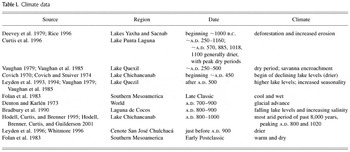
George Denton and Wibjörn Karlén (1973) note that, around a.d. 700–900, a short-lived, worldwide glacial advance took place. This was followed by glacial contraction until about a.d. 1450. William Folan and others (1983) have combined these data with Lawrence Feldman's (1978) freshwater-shell study to indicate that the Early Formative through the Early Classic, and possibly the Early Postclassic, were comparatively warm and dry in southern Mesoamerica (Table 1). They report that the Late Classic was comparatively cool and wet and therefore would have been characterized by swidden, rather than hydraulically oriented, farming techniques (Folan et al. 1983:458–459).
Climate data

However, it is clear that significant subregional differences in circum-Caribbean climate have existed from at least the Late Pleistocene era. Barbara Leyden and others (1994) state that changes in surface temperatures in the Gulf of Mexico are an important mechanism that produced variable climatic responses throughout the region. Changing weather patterns, caused by northern and southern movements of dry and wet air (Gunn and Adams 1981; Sanchez and Kutzbach 1974), mean that any general statements about climate in one area may not necessarily apply to an adjacent zone. Data collected by Thomas Whitmore and others (1996) suggest that climatic differences that are evident today, such as those between the eastern and western part of the peninsula, may have been even more extreme in the past. Like many other things about the Maya area, climate is too complex to make blanket statements about the region as a whole.
In an effort to explore better what local climates were like during critical portions of Yucatan's history, researchers have gathered data from cenotes and lakes within and immediately adjacent to the Maya area. Leyden, Whitmore, and others (Leyden et al. 1996; Whitmore et al. 1996) collected oxygen isotope, pollen, diatom, and other environmental indicators from Cenote San José Chulchaca, in northwestern Yucatan. These indicate a climatic oscillation just before a.d. 900, from a wetter and more seasonal climate to a drier phase.
In the northeast, Leyden, Whitmore, and others (Leyden et al. 1998; Whitmore et al. 1996) have also studied Lake Coba. Interestingly, at the time of the Maya collapse, Coba seems to have experienced a sharp decline in agricultural activities, followed by an immediate rebound. Native vegetation does not seem to have been affected by whatever agent caused changes in the types of pollen represented, indicating that culture, not climate, interrupted the sequence. However, since the time of peak Maya populations in the north, eastern lake levels (such as Coba's) have fallen, and levels in the west have risen.
Another northern lake that has been subjected to considerable inquiry is Lake Chichancanab. Alan Covich and M. Stuiver compared oxygen isotope levels and molluscan populations (Covich 1970; Covich and Stuiver 1974) to reveal a declining lake level, beginning about 1,500 years ago. Rates of evaporation and inflow are thought to be the main variables controlling O-18/O-16 ratios for the lake. More recent studies by David Hodell and others (1995, 2001) have refined these data, giving an age of approximately a.d. 800–1000 for the most arid period of the past 8,000 years, with two distinct events centered on a.d. 800 and 1020. Lake Punta Laguna, northeast of Coba, produced similar findings based on δO-18 values (Curtis et al. 1996). Interestingly, a dry event also appears around a.d. 920 in the Quelccaya ice core of southern Peru (Chepstow-Lusty et al. 1996).
Lakes in the Southern Lowlands have also been cored to obtain pollen sequences. The data for Lake Yaxha and Lake Sacnab have been alternately interpreted as reflecting human disturbance (Deevey et al. 1979; Rice 1996) or a dry period from a.d. 1–500 followed by wetter conditions in the Late Classic (Dahlin 1983). The former alternative appears more likely, as savannas replace forest vegetation at the same time that soil erosion and sedimentation rates increase in the lakes (Rice 1996). A Lake Peten-Itza core (Curtis et al. 1998) primarily reveals the marked effects of deforestation on the pollen record, with “no long-term changes” in oxygen and carbon isotopes during or after about 5500 b.p. (4,800 C-14 years b.p.). However, Mark Brenner and others (2001) believe that this apparent climatic consistency may reflect the fact that large-volume lakes may be less sensitive to short-term changes in the ratio of evaporation to precipitation. Nearby Lake Quezil has also been cored (Leyden et al. 1993, 1994; Vaughan 1979; Vaughan et al. 1985), revealing a dry period from a.d. 200–500, followed by higher lake levels (Dahlin 1983), as well as great cultural disturbance of the area (Leyden et al. 1994). Data from Albion Island, Belize (Bradbury et al. 1990), also indicate that the end of the Classic period was drier as lake levels fell and salinity increased. The study of cores from this portion of the Maya world are complicated by the dense populations that once occupied the area (Rice and Rice 1990). Large-scale deforestation may alter the hydrology of the lakes and associated wetlands regions, making it difficult to interpret changes in isotope records clearly (Brenner et al. 2001).
If all of these interpretations of climate in the lowlands are correct—admittedly, a problematic assumption, because many of the pollen findings have been interpreted from a limited number of measured points—then the peninsula's climate record is clearly more complex than any “wetter than today” or “drier than today” statement. Even if one accepts the data as indicative of only general trends rather than events, climate patterns appear to have acted as a shifting mosaic, with some areas experiencing marked shifts toward drier conditions while others maintained a more moderate climate. If the Classic collapse was in any way related to climate, this might explain why its effects appear to have been felt differentially.
CLIMATE-RELATED EXPLANATIONS FOR THE MAYA COLLAPSE
Past explanations for the Collapse have included subsistence-demographic and social stresses (Culbert 1988), natural disasters (MacKie 1961), disease (Spinden 1928), environmental limitations (Meggers 1954), sex ratios (Cowgill and Hutchinson 1963), invasion (Cowgill 1964), and a host of other possibilities (Adams 1973; Sabloff 1973). However, as we have come to understand better the high population densities (e.g., Culbert, Kosakowsky, Fry, and Haviland 1990; Haviland 1969) and complex agricultural practices (e.g., Siemens 1982) present at many sites, some Mayanists have turned to climate-related explanations for the collapse. Such explanations are appealing because they call on a regional phenomenon, not just site-specific events, to account for what appears to be a regional crisis. In addition, most recent theorists focusing on climate, including the author, no longer see it as the only factor involved in the collapse; instead, many researchers choose to see climate as one of several key elements. At the same time, many climate-related explanations have struggled to account for the different trajectories taken by sites and regions in the Maya area; particularly challenging to explain in any scenario is why a “dry” north would outlive a “wet” south. As our ability to detail past climatic shifts accurately improves and our understanding of the complexities of climate change increases, climate-based models are beginning to explore differential regional impacts.
Joel Gunn, Richard Adams, William Folan and others (Folan et al. 1983; Gunn and Adams 1981; Gunn and Folan 1995) have stated that the collapse may have been caused by ninth-century climate shifts “that failed to provide sufficient moisture for needed horticultural production” (Folan et al. 1983:467) as globally colder temperatures reduced rainfall in the Maya area. At the same time, this made the northern coast more desirable for salt production. Coastal salt production was also aided by receding global sea levels through the ninth century that remained low until the sixteenth century.
Lewis Messenger (1990) introduces a new interpretation of climatic data, based on W. A. Sanchez and J. E. Kutzbach's (1974) study of weather during the 1960s. Between a.d. 800–1000, climate became unstable, and a global-warming trend began (Messenger 1990:36), which Messenger believes actually increased rainfall by about 10% in much of the northern and north-central Maya area (modern Belize, the northern Peten of Guatemala, and the states of Yucatan, Quintana Roo, and Campeche). At the same time, Messenger proposes, parts of highland Chiapas and Guatemala would have received approximately 10% less precipitation. This may have upset regional interdependence, as the “have-nots” in dry regions (such as the Northern Lowlands) crossed a critical threshold enabling them to support increasingly large populations and participate in the regional economy and politics in ways never before possible. A minor increase, or even a slight decrease, in the “haves” (Southern Lowlands) area would not have had such an effect.
Jason Curtis and others (1996) point out that a period of extreme aridity between a.d. 800–900 does coincide with the southern collapse. They believe that, although the north is drier, the south would have been affected more severely by any decrease in rainfall, because the south has a water table much farther below the ground surface and a greater dependence on surface water reservoirs. Northern sites would have continued access to water through most cenotes and several lakes (Chichancanab, Coba, Punta Laguna, San José Chulchaca, Sayaucil, and Yalahau). Although these centralized water sources would not have supplied the agricultural needs of the hinterland, they would have permitted immediately adjacent populations to be maintained during dry periods.
Each of these theorists presents ideas that grapple with the north–south dichotomy seen in the archaeological record. They provide reasonable explanations of why the north might indeed have fared better than the south under a given set of conditions. However, none of these hypotheses truly deals with the apparent “mosaic” of trajectories that appears to have taken place. All sites in the south did not uniformly collapse, just as all sites in the north did not consistently flourish. Likewise, failure and success may not always be predicted by distance from the coast or depth of the water table. Although these factors certainly may have played a part in encouraging or discouraging the survival of sites, it seems that other forces must have come into play to account for the non-uniform pattern.
ANTHROPOGENIC CLIMATE CHANGE AND THE MAYA COLLAPSE
These theories do allow for some regional variability, but they still predict that large zones would have been subject to the same basic conditions and therefore reacted in much the same way. The hypothesis that will be presented here may better take into account the apparent “mosaic” pattern of climate data, as well as the more general trend toward drying, as it involves the effects of human actions, particularly those leading to deforestation. It is known that widespread forest clearance decreases evapotranspiration and reduces precipitation in a feedback effect (Dahlin 1983; Hutjes et al. 1998). This deforestation, coupled with other systemic problems, may have made it difficult, or impossible, to sustain dense populations around some major centers.
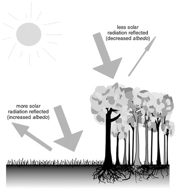
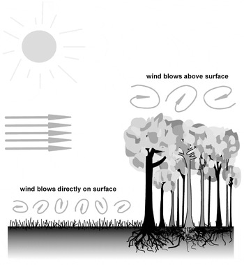
Studies of modern deforestation (Ghuman and Lal 1987a, 1987b; Laurance 1998; Shukla et al. 1990; Walker et al. 1995) have shown that, when trees are removed, the local climate becomes warmer and drier. There are several reasons for this change: the albedo (Figure 2), or “ratio of the amount of solar radiation reflected by a body to amount incident upon it” (O'Brien 1996:313); “roughness length,” or surface air drag of the vegetation cover (Walker et al. 1995) (Figure 3); and the Bowen ratio, or partitioning of net surface radiation between sensible and latent heat fluxes (Eltahir and Pal 1996:26237). Albedo increases as grasses, crops, and bare earth replace forests; although the relative values of the albedo differ significantly, however, the amount of the absorbed energy is not much different (80% of the sun radiation energy for cleared areas and 88% for forested areas). The absorbed heat causes an increase in the temperature of the absorbing system. The resulting temperature is a function of the masses and heat capacities of the components of the system. With a cleared system, the components are the soil, the grasses, and the air trapped in them. With a forested system the components are the soil (and its humus cover), the tree trunks and branches, the canopy, and the air trapped within that system. The mass of the heated components in the forested system is much larger than in the cleared system, resulting in a lower temperature for the whole forested system relative to the cleared one.

Surface albedo in forested and cleared areas. Adapted from O'Brien 1996.

Roughness length in forested and cleared areas. Adapted from O'Brien 1996.
The air mass under the canopy is significantly larger than that in the cleared system and, at the same temperature, can absorb correspondingly larger amounts of humidity from the soil surface and from the plants. The air in the cleared system is at a higher temperature and is thus capable of absorbing relatively larger amounts of humidity, but because the mass of this air is much smaller, the total amount of vapor absorbed by the forested system is larger than that absorbed by the cleared system. In this case, the Bowen ratio, or the ratio between the heat radiated by the surface to the heat used up to evaporate some of the humidity of the system, is larger for the cleared system. Thus, with the cleared system, less humidity is absorbed from the soil surface (Eltahir and Pal 1996; O'Brien 1996, 2000; Walker et al. 1995).
However, another component changes the situation: the wind. The mixing effects of the wind are expressed technically by the values of the “roughness length” through a complicated turbulent flow theory. This is not the place to detail the theory, but it will suffice to note that, with the canopy, the large-scale wind blows above it, causing very little mixing of the air below it. The saturated air near the surface does not stir and blocks further evaporation from the soil surface. With cleared systems, the wind blows almost directly over the surface, constantly replacing saturated air with drier air, thus enhancing evaporation from the surface by orders of magnitude. In addition, with less plant surface present to evaporate water, moisture that does fall is quickly released as erosive runoff, or to the subsurface flow (Laurance 1998; Lawson et al. 1981), where it would be less available to humans or the shallow roots of most crops.
Another process that affects the higher desiccation rate of cleared areas is the diurnal cycle of temperature and wind. While climatic shifts, as discussed earlier, affect entire regions when the scale of changes in land cover is large enough (Hutjes et al. 1998; O'Brien 1996, 2000), any regional transformations essentially result from the cumulative effects of initial alterations in local surface rainfall. Changes in local surface conditions are primarily the result of a modification in the surface energy balance driven by changes in the surface albedo and Bowen ratio (Eltahir and Pal 1996). Researchers (Bastable et al. 1993; de Souza et al. 1996; Salati and Vose 1984), comparing cleared and undisturbed Amazonian forest, have found that temperature, wind, and humidity differences existed between the two zones. The average daily temperature over clearings was almost twice that recorded above the forest over a sixty-day period. Strong diurnal inversions developed over cleared areas, causing winds near the surface to separate from atmospheric winds, triggering wind speeds to drop near zero at night near cleared exposures. While this means that air over clearings frequently became saturated with moisture overnight, leading to morning fog and dew, humidity levels then dropped to zero as higher temperatures caused moisture to evaporate rapidly. Uncleared forests lacked these sharp swings in humidity, with some humidity remaining in the air throughout the day. All of these differences were more pronounced during dry periods and may continue to worsen through time, as changes to the surface climate may take two or more years to become fully established in the root zone (Henderson-Sellers et al. 1993).
Researchers report similar results from studies of Nigerian deforestation (Ghuman and Lal 1987a, 1987b; Lawson et al. 1981), as well as from recent studies of land use changes in Costa Rica (Carlson and Sanchez-Azofeifa 1999). In Costa Rica, areas undergoing urbanization with less vegetation cover displayed higher surface temperatures, less evapotranspiration, and generally drier surfaces. Interestingly, when certain crops replace forests, much smaller changes in surface temperatures and wetness result.
Neither the Amazon nor Nigeria has an environment like that of the Maya area. Therefore, figures from these studies cannot be applied directly to the Maya Lowlands. However, these studies from different parts of the world do indicate that when deforestation occurs, the same general effects may be felt. The removal of forest from large expanses of land, and the maintenance of short vegetation and/or bare earth, raises temperatures and decreases evapotranspiration. Unless the weather pattern of an area is such that it receives the majority of the moisture for its rainfall budget elsewhere (ocean), this may result in a significant reduction in rainfall.
P. Bernard Tinker and others (1996) have examined the effects that slash-and-burn agriculture has on climate. With long fallow periods and large areas of undisturbed forests, swidden agriculture does provide a balanced, sustainable system. However, when population and/or land pressures cause an increasing proportion of land in a given region to be either under cultivation or recently cleared, deforestation occurs. As stated, the result of this biomass change will depend to some degree on local conditions. If local rainfall is largely dependent on the return of evaporated water, then lower evapotranspiration will result in marked decreases in rainfall. Effects would be much less severe near coasts or on islands with water vapor brought in by oceans. For this reason, Amazonia and the interior of the Maya area might be relatively more susceptible to anthropogenic climate change than Southeast Asia or northern and eastern Yucatan. The Northern Lowlands and eastern coast depend on receiving summer rainfall from the east. On a daily basis, the “double sea breeze effect” brings summer rains along the coast (Mosiño Aleman 1963). Much less of northern rainfall comes from evapotranspiration, as the thorny scrub vegetation of the dry north has evolved so as not to lose large quantities of its precious water (Thien et al. 1982). It is possible that when scattered deforestation occurred in the north and along the eastern coast, a smaller percentage of the total moisture budget was lost. The south, particularly the interior of the peninsula, is probably more dependent on rainfall maintained through evapotranspiration and may therefore have suffered disproportionately when large areas became deforested.
Another factor that would have caused the south to be affected disproportionately by any drought is the depth of the water table relative to the ground surface. Groundwater is actually more accessible in the Northern Lowlands than in the Southern Lowlands, as the depth of the water table decreases northward (Brenner et al. 2001:95; Curtis et al. 1996). The susceptibility of north and south to marked water declines may have been further affected by other agricultural practices particular to each region. With the exception of the El Eden wetlands (Fedick 1998), studies of agricultural practices in the north have thus far revealed a lack of obvious relic agricultural features (Dunning 1996). Instead, features related to water-conservation practices are present, such as the naturally occurring damp depressions (rejolladas and bajadas), chich mounds of piled stone that may have helped to stabilize and conserve water around tree crops, rock-covered fields that retain moisture, and other features built to create damper microclimates (Beach 1998; Kepecs and Boucher 1996). In the south, however, the focus appears to have been on channeling and utilizing a seasonal (or year-round) water surplus. Reservoirs filled by architecturally directed water flows (Scarborough 1996, 1998), raised fields (Harrison 1990), canals or ditches (Pohl and Bloom 1996), drained fields, check-dams and walls to direct runoff (Culbert, Levi, and Cruz 1990; Scarborough 1996), and terraces to stem erosion (Dunning 1996; Turner 1974) are more typical of the Southern Lowlands. The southern system was set up to deal with seasonal excess, while the northern system was designed for water savings. These differences may have become critical when shortages did result.
It is apparent that deforestation was widespread in the south by the Late Classic period. Such clearing is seen in cores from the Peten (Binford et al. 1987; Curtis et al. 1998; Rice 1996), indicating forest clearance for agriculture in pollen profiles with corn pollen (Zea), grasses, and weeds of cultivation increasing and tree pollen dwindling. In addition, there is a rise in the incidence of burned organic fragments that parallels the development of Maya civilization and an increase in soil erosion and sedimentation rates as grasses, crops, and newly cleared fields failed to retain sediments to the degree that trees had (Rice 1996). Although evidence indicates that, by the Early Classic, humans had had a drastic impact on many areas (Dunning et al. 1999), the disturbance-type taxa reached a maximum at about a.d. 880 in the Peten. Don Rice (1996:201) believes that these changes were sufficient to alter the region's microclimate. Only after the collapse is there a resurgence of tropical forest pollen (Leyden et al. 1994; Vaughan et al. 1985). Even where forests were not cleared, human hunting may have exacerbated this situation. When top carnivores are eliminated, seed eaters may increase rapidly and reduce the number of large-seeded tree species (Laurance 1998). In the north, at Lake Coba (Leyden et al. 1998) and Cenote San José Chulchaca (Leyden et al. 1996), Leyden and others also noted human disturbance. However, the agricultural activity in these regions appears to have been more intermittent and the deforestation less complete.
Deforestation carried out around centers in the south may have assisted in the formation of the “mosaic” appearance that current evidence presents. Those centers with the most extreme deforestation would experience local desiccation peaks, although the region as a whole would be affected to some degree. When rainfall did come to heavily deforested areas, it would not be softened and absorbed by the various layers of the canopy; instead, it would fall directly on ground that was bare or secured by minimal vegetation, causing substantial erosion and flooding that might give the appearance of a wetter cycle that Bruce Dahlin (1983) initially reported for Lake Yaxha and Lake Sacnab. Cores from southern lakes do show an increase in the amount of sediment inflow at this time (Rice 1996).
When an apparent regional dry period peaking around a.d. 900 coupled with the effects of local deforestation, the south's equilibrium was upset. Drought and famine may initially have affected primarily the poor, but the effects were soon felt higher up the social ladder. Although more ethnometeorological studies are needed to predict precisely how people might have reacted to this catastrophe, Richardson Gill (2000) believes that the Maya are likely to have responded with expanded governmental control, ritual intensification, and increasing conflicts. The loss of rainfall alone did not cause the Collapse. Instead, it probably entered a feedback relationship with established agricultural systems and growing political strife shown in warfare. Divine kings became unable to guarantee sufficient rainfall. The surplus production needed to support elites and full-time specialists was no longer available. Warfare, aimed at solving the problem, aggravated the situation by disrupting the agricultural cycle and displacing farmers. Even if a food surplus had existed in some areas, no efficient transportation system existed to import sufficient foodstuffs to ease the crisis, and migration was not a viable solution for potentially millions of people (Gill 2000). While many died, remaining populations appear to have dispersed at a low density in the south, perhaps to regions less affected by deforestation, as well as to the north, which was able to continue its Late Classic trajectory through the Terminal Classic.
Kevin Johnston (1997, 2000) raises an interesting issue regarding why the Maya did not reverse or slow the process of widespread deforestation once it began. He argues that ancient Maya farming practices, much like traditional farming techniques still in use today by some modern Maya, require a large labor pool to clear, burn, plant, weed, and harvest plots of land. The immediate and extended family, which could be expanded only by marriage and the production of children, formed the primary labor pool for agricultural production. Although having more children increased the population and required more food, each family depended on this expanding labor force to sustain itself. These ideas are consistent with John Caldwell's (1982:139–147) “Wealth Flows Theory” of demographic change, which states that unlimited fertility is economically rational where the flow of wealth goes from children to parents, yet zero fertility is economically rational where the flow is reversed. The system built on continued population growth functioned well for the individual family, but when totaled it meant that agriculturally successful populations were increasing populations with larger and larger areas currently or recently under cultivation. Intensifying production to feed a growing population through land improvement (terracing, irrigating, mulching, etc.), increasing the number of years a field is successively cropped (encouraging weed growth), and/or reducing the fallow cycle (degrading the environment and requiring mulching or other actions to avoid diminishing returns) would serve only to create a further need for labor. The founding and expansion of many southern Maya sites prior to the development of numerous large northern sites may have meant that southern populations, and their populations' deforestation for agriculture, also reached a critical point before the north. When anthropogenic rainfall reduction, possibly coupled with a worldwide cooling trend, took place in large, competing systems with a substantial non-farming elite class, disaster occurred.
CONCLUSIONS
Although environmental determinism is not being proposed as a viable means to explain entirely the Classic Maya Collapse, climate change—particularly that tied to human actions—should be investigated as one significant factor that may have exacerbated systems that were already out of balance. As increasing populations deforested larger areas, microclimates and regional climates changed, possibly exacerbated by what may have already been a cooler period worldwide. A growing elite made escalating demands upon the populace, and warfare disrupted the agricultural cycle and displaced peasants. Some systems collapsed, leaving only low-density occupations, while others in different settings using other strategies were able to continue or even thrive. Anthropogenic rainfall reduction alone was not sufficient to doom a healthy, well-balanced society, but it certainly seems possible that aridity brought on by deforestation served as an important catalyst helping to launch the Southern Lowlands on the path to system collapse. More oxygen-isotope studies, as well as pollen studies and settlement research to document better the degree to which populations were affected by events at the Late to Terminal Classic transition, are needed to begin to test the possible role that deforestation may have played in the Collapse and in the differential survival of the north.
RESUMEN
Durante el siglo IX muchos de los sitios mayas en las tierras bajas del sur fueron abandonados tanto por la clase alta como por las otras clases sociales cuando sintieron los efectos del colapso al finales período clásico. Al mismo tiempo, los sitios al norte y al este seguían prosperando, aún alcanzando el apogeo en la cantidad de sus habitantes durante el período clásico terminal. Los datos climatológicos recién obtenidos indican que durante esta transición del período clásico tardío al clásico terminal, una gran parte del área maya experimentó una sequía significante durante lo que parece haber sido un período global relativamente fresco. Sin embargo, no parece que esta sequía afectara a toda la región uniformemente. Al contrario, el clima parece haber funcionado como un mosaico, cambiando a través del tiempo y el espacio, el cual fue impactado tanto por fuerzas culturales como por naturales. Se puede formular la hipótesis de que uno de los factores claves responsables por las trayectorias variables culturales documentadas en el área maya es el cambio climatológico local y regional causado por una deforestación antropogénica e irregular. En estudios realizados en otras partes del mundo, la destrucción del bosque en áreas extensas y el mantenimiento de la vegetación baja están asociados con el incremento de las temperaturas y el descremento de la evaporatranspiración. En regiones que no reciben significante humedad de otras partes para sus necesidades pluviales, pueden resultar significantes disminuciones en su cantidad pluvial. Estos cambios micro- y macro-climáticos, junto con un sistema cultural ya desequilibrado, pueden haber servido como un catalizador que condujo algunas partes del mundo maya hacia un fallo del sistema, mientras que otras zonas fueron capaces—por lo menos temporalmente—de ajustarse y continuar.
ACKNOWLEDGMENTS
I thank T. Patrick Culbert for first introducing me to the Maya as a young archaeology student at the University of Arizona. The balanced, detailed presentation he provided left no doubt in my mind that I had to spend my career working in the Maya area. I also thank Dave Johnstone and Yoav Me-Bar for reading and editing several drafts of this manuscript; their comments and suggestions vastly improved the depth and flow of the paper. In addition, I am grateful to Richardson Gill, Kevin Johnston, Lewis Messenger, and an anonymous reviewer for providing excellent comments on the content and structure of the manuscript; any errors or omissions in the article, however, are entirely my fault. I thank Tom and Mary Lou Shaw for years of unflagging support. My family and friends have been incredibly patient and supportive. I thank David Freidel for giving me my first opportunity to work in the Northern Lowlands and Bill Rathje for his continued encouragement.
I acknowledge the funding agencies that have made my research at Yo'okop possible: the Antiqua Foundation, the Selz Foundation, the H. John Heinz III Fund of the Heinz Family Foundation (reference number H1305) and the Foundation for the Advancement of Mesoamerican Studies, Inc., (FAMSI, project number 99016). I am indebted to the people of Saban and Huay Max who graciously allow me to live and work in their ejido. We hope that the Proyecto Arqueologico Yo'okop can continue for many years and serve to test many of the ideas contained in this paper.
References
REFERENCES
Adams, Richard E.W.
1973
The Collapse of Maya Civilization: A Review of Preview Theories.
In
The Classic Maya Collapse, edited by
T. Patrick Culbert, pp.
21–34.
University of New Mexico Press,
Albuquerque.
Andrews, Anthony P.
1990
The Fall of Chichén Itzá: A Preliminary Hypothesis.
Latin American Antiquity
1(3):258–267.Google Scholar
Andrews, Anthony P., and
Fernando Robles C.
1985
Chichén Itzá and Cobá: An Itza–Maya
Standoff in Early Postclassic Yucatán. In
The Lowland Maya Postclassic, edited by
Arlen F. Chase and
Prudence M. Rice, pp.
62–72.
Bastable, H.G.,
W.J. Shuttleworth,
R.L.G. Dallarosa,
G. Fisch, and
C.A. Noble
1993
Observations of Climate, Albedo, and Surface Radiation over Cleared
and Undisturbed Amazonian Forest.
International Journal of Climatology
13:783–796.Google Scholar
Beach, Timothy
1998
Soil Constraints on Northwest Yucatan, Mexico: Pedoarchaeology and
Maya Subsistence at Chunchucmil.
Geoarchaeology
13(8):759–791.Google Scholar
Becquelin, Pierre,
Dominique Michelet,
Marie-Charlotte Arnauld, and
Eric Taladoire
1994
Proyecto Arqueológico Xcalumkín, en su trayectoria
cronológica: Segunda temporada (Enero–Marzo de 1993).
Mexicon
16(5):93–99.Google Scholar
Binford, Michael,
Mark Brenner,
Thomas Whitmore,
Antonia Higuera-Gundy, and
E.S. Deevey
1987
Ecosystems, Paleoecology, and Human Disturbance in Subtropical and
Tropical America.
Quaternary Science Reviews
6:115–128.Google Scholar
Bradbury, J. Platt,
R.M. Forester,
W. Anthony Bryant, and
A.P. Covich
1990
Paleolimnology of Laguna de Cocos, Albion Island, Rio Hondo,
Belize. In
Ancient Maya Wetland Agriculture: Excavations on Albion Island,
Northern Belize, edited by
Mary DeLand Pohl, pp.
119–154.
Westview Press,
Boulder, CO.
Brenner, Mark,
David Hodell,
Jason Curtis,
Michael Rosenmeier,
Michael Binford, and
Mark Abbott
2001
Abrupt Climate Change and Pre-Columbian Cultural Collapse. In
Interhemispheric Climate Linkages, edited by
Vera Markgraf, pp.
87–103.
Academic Press,
New York.
Burgos V., Rafael, and
Antonio Benavides C.
1983
El material ceramico de Chacmultun, Yucatán.
Boletin E.C.A.U.D.Y.
10(59):30–40.Google Scholar
Caldwell, John C.
1982
Theory of Fertility Decline.
Academic Press,
London.
Carlson, T.N., and
G.A. Sanchez-Azofeifa
1999
Satellite Remote Sensing of Land Use Changes in and around San
José, Costa Rica.
Remote Sensing and Environment
70:247–256.Google Scholar
Chase, Arlen F.
1990
Maya Archaeology and Population Estimates in the Tayasal-Paxcaman
Zone, Peten, Guatemala. In
Precolumbian Population History in the Maya Lowlands, edited by
T. Patrick Culbert and
Don S. Rice, pp.
149–165.
University of New Mexico Press,
Albuquerque.
Chase, Arlen F., and
Diane Z. Chase
1987
Investigations at the Classic Maya City of Caracol, Belize:
1985–1987.
Pre-Columbian Art Research Institute Monograph 3.
San Francisco.
Chepstow-Lusty, A.J.,
K.D. Bennett,
V.R. Switsur, and
A. Kendall
1996
4,000 Years of Human Impact and Vegetation Change in the Central Peruvian
Andes—with Events Paralleling the Maya Record?
Antiquity
70:824–833.Google Scholar
Covich, Alan P.
1970
Stability of Molluscan Communities: A Paleolimnologic Study of
Environmental Disturbance in the Yucatan Peninsula.
Ph.D. dissertation, Yale University, New Haven, CT.
University Microfilms,
Ann Arbor, MI.
Covich, Alan, and
M. Stuiver
1974
Changes in Oxygen 18 as a Measure of Long-Term Fluctuations in
Tropical Lake Levels and Molluscan Populations.
Limnology and Oceanography
19:682–691.Google Scholar
Cowgill, George
1964
The End of Classic Maya Culture: A Review of Recent Evidence.
Southwestern Journal of Anthropology
20(2):145–159.Google Scholar
Cowgill, Ursula, and
George Hutchinson
1963
Sex-ratio in Childhood and the Depopulation of the Peten, Guatemala.
Human Biology
35(1):90–103.Google Scholar
Culbert, T. Patrick
1973
The Maya Downfall at Tikal. In
The Classic Maya Collapse, edited by
T. Patrick Culbert, pp.
63–92.
University of New Mexico Press,
Albuquerque.
Culbert, T. Patrick
1988
The Collapse of Classic Maya Civilization. In
The Collapse of Ancient States and Civilizations, edited by
Norman Yoffee and
George L. Cowgill, pp.
69–101.
University of Arizona Press,
Tucson.
Culbert, T. Patrick
1991
Maya Political History and Elite Interaction: A Summary View. In
Classic Maya Political History: Hieroglyphic and Archaeological
Evidence, edited by
T. Patrick Culbert, pp.
311–345.
School of American Research, Advanced Seminar Series.
Cambridge University Press,
New York.
Culbert, T. Patrick,
Laura J. Levi, and
Luis Cruz
1990
Lowland Maya Wetland Agriculture: The Rio Azul Agronomy Program.
In
Vision and Revision in Maya Studies, edited by
Flora S. Clancy and
Peter D. Harrison, pp.
114–124.
University of New Mexico Press,
Albuquerque.
Culbert, T. Patrick,
Laura J. Kosakowsky,
Robert E. Fry, and
William Haviland
1990
The Population of Tikal, Guatemala. In
Precolumbian Population History in the Maya Lowlands, edited by
T. Patrick Culbert and
Don S. Rice, pp.
103–121.
University of New Mexico Press,
Albuquerque.
Curtis, Jason,
David A. Hodell, and
Mark Brenner
1996
Climate Variability on the Yucatán Peninsula (Mexico) during
the Past 3,500 Years, and Implications for Maya Cultural Evolution.
Quaternary Research
46:37–47.Google Scholar
Curtis, Jason H.,
Mark Brenner,
David A. Hodell,
Richard A. Balser,
Gerald A. Islebe, and
Henry Hooghiemstra
1998
A Multi-Proxy Study of Holocene Environmental Change in the Maya
Lowlands of Peten, Guatemala.
Journal of Paleolimnology
19:139–159.Google Scholar
Dahlin, Bruce
1983
Climate and Prehistory on the Yucatán Peninsula.
Climate Change
5:245–263.Google Scholar
Deevey, E.S.,
Don Rice,
Prudence Rice,
H.H. Vaughan,
Mark Brenner, and
M.S. Flannery
1979
Mayan Urbanism: Impact on a Tropical Karst Environment.
Science
206:298–306.Google Scholar
Denton, George H., and
Wibjörn Karlén
1973
Holocene Climatic Variations—Their Pattern and Possible Cause.
Quaternary Research
3:155–205.Google Scholar
de Souza, J.R.S.,
F.M.A. Pinheiro,
R.L.C. de Araujo,
H.S. Pinheiro_Jr., and
M.G. Hodnett
1996
Temperature and Moisture Profiles in Soil Beneath Forest and Pasture
Areas in Eastern Amazonia, In
Amazonian Deforestation and Climate, edited by
J.H.C. Gash,
C.A. Nobre,
J.M. Roberts, and
R.L. Victoria, pp.
125–137.
John Wiley and Sons,
New York.
Dunning, Nicholas
1996
A Reexamination of Regional Variability in the Pre-Hispanic
Agricultural Landscape, In
The Managed Mosaic: Ancient Maya Agriculture and Resource Use, edited by
Scott L. Fedick, pp.
53–68.
University of Utah Press,
Salt Lake City.
Dunning, Nicholas,
Vernon Scarborough,
Fred Valdez_Jr.,
Sheryl Luzzadder-Beach,
Timothy Beach, and
John G. Jones
1999
Temple Mountains, Sacred Lakes, and Fertile Fields: Ancient Maya
Landscapes in Northwestern Belize.
Antiquity
73(281):650–660.Google Scholar
Eltahir, Elfatih, and
Jeremy S. Pal
1996
Relationship between Surface Conditions and Subsequent Rainfall in
Convective Storms.
Journal of Geophysical Research
101(D21):26237–26245.Google Scholar
Fedick, Scott
1998
Ancient Maya Use of Wetlands in Northern Quintana Roo, Mexico. In
Hidden Dimensions: The Cultural Significance of Wetland
Archaeology, edited by
K. Bernick, pp.
107–129.
University of British Columbia Press,
Vancouver.
Folan, William,
Joel Gunn,
Jack D. Eaton, and
Robert W. Patch
1983
Paleoclimatological Patterning in Southern Mesoamerica.
Journal of Field Archaeology
10:453–467.Google Scholar
Ghuman, B.S., and
Rattan Lal
1987a
Effects of Deforestation on Soil Properties and Microclimate of a
High Rain Forest in Southern Nigeria. In
The Geophysiology of Amazonia: Vegetation and Climate Interactions, edited by
Robert E. Dickinson, pp.
225–244.
John Wiley and Sons,
New York.
Ghuman, B.S., and
Rattan Lal
1987b
Effects of Partial Forest Clearing on Microclimate in a Humid
Tropical Forest.
Agricultural and Forest Meteorology
40:17–29.Google Scholar
Gill, Richardson B.
2000
The Great Maya Droughts.
University of New Mexico Press,
Albuquerque.
Gunn, Joel, and
Richard E.W. Adams
1981
Climatic Change, Culture, and Civilization in North America.
World Archaeology
13(1):87–100.Google Scholar
Gunn, Joel, and
William J. Folan
1995
Three Rivers: Interregional Global Climate Response Surface for the
Southwestern Maya Lowlands (Candelaria, Usumacina, and Champotón
Watersheds).
Paper presented at the 1995 Campechano Conference, Campeche,
Campeche, Mexico.
Harrison, Peter D.
1990
The Revolution in Ancient Maya Subsistence. In
Vision and Revision in Maya Studies, edited by
Flora S. Clancy and
Peter D. Harrison, pp.
99–113.
University of New Mexico Press,
Albuquerque.
Haviland, William
1969
A New Population Estimate for Tikal, Guatemala.
American Antiquity
34(4):429–433.Google Scholar
Henderson-Sellers, A.,
R.E. Dickinson,
T.B. Burbidge,
P.J. Kennedy,
K. McGuffie, and
A.J. Pitman
1993
Tropical Deforestation: Modeling Local- to Regional-Scale Climate
Change.
Journal of Geophysical Research
98(D4):7289–7315.Google Scholar
Hodell, David,
Jason H. Curtis, and
Mark Brenner
1995
Possible Role of Climate in the Collapse of the Classic Maya
Civilization.
Nature
375(1):391–394.Google Scholar
Hodell, David,
Mark Brenner,
Jason H. Curtis, and
Thomas Guilderson
2001
Solar Forcing of Drought Frequency in the Maya Lowlands.
Science
292:1367–1370.Google Scholar
Hutjes, R.W.A.,
P. Kabat,
S.W. Running,
W.J. Shuttleworth,
C. Field,
B. Bass,
M.A.F. da Silva Dias,
R. Avissar,
A. Becker,
M. Claussen,
A.J. Dolman,
R.A. Feddes,
M. Fosberg,
Y. Fukushima,
J.H.C. Gash,
L. Guenni,
H. Hoff,
P.G. Jarvis,
I. Kayane,
A.N. Krenke,
Changming Liu,
M. Meybeck,
C.A. Nobre,
L. Oyebande,
A. Pitman,
R.A. Pielke Sr.,
M. Raupach,
B. Saugier,
E.D. Schulze,
P.J. Sellers,
J.D. Tenhunen,
R. Valentini,
R.L. Victoria, and
C.J. Vorosmarty
1998
Biospheric Aspects of the Hydrological Cycle.
Journal of Hydrology
212–213:1–21.Google Scholar
Johnston, Kevin
1997
La ecología de la agricultura tropical y el colapso de los
Maya clásicos. In
IX simposio de arqueología Guatemalteca.
Museo Nacional de Arqueología e Etnología,
Guatemala.
Johnston, Kevin
2000
What Goes Up Must Come Down: Malthus, Boserup, and the Maya
Collapse.
Paper presented at the 65th Annual Meeting of the Society for
American Archaeology,
Philadelphia.
Jones, Christopher
1991
Cycles of Growth at Tikal. In
Classic Maya Political History: Hieroglyphic and Archaeological
Evidence, edited by
T. Patrick Culbert, pp.
102–127.
School of American Research, Advanced Seminar Series.
Cambridge University Press,
New York.
Kepecs, Susan, and
Sylviane Boucher
1996
The Pre-Hispanic Cultivation of Rejolladas and
Stone-Lands: New Evidence from Northeast Yucatán. In
The Managed Mosaic: Ancient Maya Agriculture and Resource Use,
edited by
Scott L. Fedick, pp.
69–91.
University of Utah Press,
Salt Lake City.
Laurance, William F.
1998
A Crisis in the Making: Responses of Amazonian Forests to Land Use
and Climate Change.
TREE
13(10):411–415.Google Scholar
Lawson, T.L.R. Lal, and
K. Oduro-Afriyie
1981
Rainfall Redistribution and Microclimatic Changes over a Cleared
Watershed. In
Tropical Agricultural Hydrology: Watershed Management and Land Use, edited by
R. Lal and
E.W. Russell, pp.
141–151.
John Wiley and Sons,
New York.
Leyden, Barbara,
Mark Brenner, and
Bruce Dahlin
1998
Cultural and Climatic History of Cobá, a Lowland Maya City
in Quintana Roo, Mexico.
Quaternary Research
49:111–122.Google Scholar
Leyden, Barbara,
Mark Brenner,
David A. Hodell, and
Jason H. Curtis
1993
Late Pleistocene Climate in the Central American Lowlands. In
Climate Change in Continental Isotopic Records.
Geophysical Monograph 78.
American Geophysical Union.
Leyden, Barbara,
Mark Brenner,
David A. Hodell, and
Jason H. Curtis
1994
Orbital and Internal Forcing of Climate on the Yucatán
Peninsula for the Past ca. 36ka.
Paleogeography, Paleoclimatology, Paleoecology
109:193–210.Google Scholar
Leyden, Barbara,
Mark Brenner,
Tom Whitmore,
Jason Curtis,
Dolores Piperno, and
Bruce Dahlin
1996
A Record of Long- and Short-Term Climatic Variation from Northwest
Yucatán: Cenote San José Chulchaca. In
The Managed Mosaic: Ancient Maya Agriculture and Resource Use,
edited by
Scott L. Fedick, pp.
30–50.
University of Utah Press,
Salt Lake City.
MacKie, Euan
1961
New Light on the End of the Classic Maya Culture at Benque Viejo,
British Honduras.
American Antiquity
27(2):216–224.Google Scholar
Meggers, Betty
1954
Environmental Limitation on the Development of Culture.
American Anthropologist
56(5):801–824.Google Scholar
Messenger, Lewis
1990
Ancient Winds of Change: Climatic Settings and Prehistoric Social
Complexity in Mesoamerica.
Ancient Mesoamerica
1:21–40.Google Scholar
Mosiño Aleman, Pedro
1963
Factores determinantes del clima en la republica Mexicana con
referencia especial a los zonas áridas.
Publication No. 19.
Instituto Nacional del Antropología e Historia, Departmento de
Prehistoria,
México, DF.
O'Brien, Karen
1996
Tropical Deforestation and Climate Change.
Progress in Physical Geography
20(3):311–335.Google Scholar
O'Brien, Karen
2000
Upscaling Tropical Deforestation: Implications for Climate Change.
Climatic Change
44:311–329.Google Scholar
Pohl, Mary D., and
Paul Bloom
1996
Prehistoric Maya Farming in the Wetlands of Northern Belize: More
Data from Albion Island and Beyond. In
The Managed Mosaic: Ancient Maya Agriculture and Resource Use, edited by
Scott L. Fedick, pp.
145–164.
University of Utah Press,
Salt Lake City.
Rice, Don S.
1996
Paleoliminological Analysis in the Central Petén,
Guatemala. In
The Managed Mosaic: Ancient Maya Agriculture and Resource Use, edited by
Scott L. Fedick, pp.
193–206.
University of Utah Press,
Salt Lake City.
Rice, Don S., and
Prudence M. Rice
1990
Population Size and Population Change in the Central Peten Lake
Region, Guatemala. In
Pre-Columbian Population History in the Maya Lowlands, edited by
T. Patrick Culbert and
Don Rice, pp.
123–148.
University of New Mexico Press,
Albuquerque.
Robles C., Fernando, and
Anthony P. Andrews
1986
A Review and Synthesis of Recent Postclassic Archaeology in
Northern Yucatán, Mexico. In
Household and Community in the Mesoamerican Past, edited by
R.R. Wilk and
W. Ashmore, pp.
53–97.
University of New Mexico Press,
Albuquerque.
Sabloff, Jeremy
1973
Major Themes in Past Hypotheses of the Maya Collapse. In
The Classic Maya Collapse, edited by
T. Patrick Culbert, pp.
35–42.
Sabloff, Jeremy, and
E. Wyllys Andrews V (editors)
1986
Late Lowland Maya Civilization: Classic to Postclassic.
University of New Mexico Press,
Albuquerque.
Salati, E., and
P.B. Vose
1994
Amazon Basin: A System in Equilibrium.
Science
225:129–138.Google Scholar
Sanchez, W.A., and
J.E. Kutzbach
1974
Climate of the American Tropics and Subtropics in the 1960s and
Possible Comparisons with Climatic Variations of the Last Millenium.
Quaternary Research
4:128–135.Google Scholar
Scarborough, Vernon
1996
Reservoirs and Watersheds in the Central Maya Lowlands. In
The Managed Mosaic: Ancient Maya Agriculture and Resource Use, edited by
Scott L. Fedick, pp.
304–314.
University of Utah Press,
Salt Lake City.
Scarborough, Vernon
1998
Ecology and Ritual: Water Management and the Maya.
Latin American Antiquity
9(2):135–159.Google Scholar
Schele, Linda, and
David Freidel
1990
A Forest of Kings: The Untold Story of the Ancient Maya.
William Morrow,
New York.
Sharer, Robert
1991
Diversity and Continuity in Maya Civilization: Quirigua as a Case
Study. In
Classic Maya Political History: Hieroglyphic and Archaeological
Evidence, edited by
T. Patrick Culbert, pp.
180–198.
School of American Research, Advanced Seminar Series.
Cambridge University Press,
New York.
Shaw, Justine M.
1998
The Community Settlement Patterns and Residential Architecture of
Yaxuná from a.d. 600–1400.
Ph.D. dissertation,
Southern Methodist University,
Dallas.
Shukla, J.,
C. Noble, and
P. Sellers
1990
Amazonian Deforestation and Climate Change.
Science
247:1322–1325.Google Scholar
Siemens, Alfred H.
1982
Prehispanic Agricultural Use of the Wetlands of Northern Belize.
In
Maya Subsistence: Studies in Memory of Dennis E. Puleston,
edited by
Kent V. Flannery, pp.
205–225.
Academic Press,
New York.
Spinden, Herbert
1928
The Ancient Civilizations of Mexico and Central America.
American Museum of Natural History Handbook Series No. 3.
American Museum of Natural History,
New York.
Thien, Leonard,
Anne S. Bradburn, and
Arthur Welden
1982
The Woody Vegetation of Dzibilchaltun, a Maya Archaeological Site
in Northwest Yucatan, Mexico.
Middle American Research Institute Occasional Paper No. 5.
Tulane University,
New Orleans.
Tinker, P. Bernard,
John S.I. Ingram, and
Sten Struwe
1996
Effects of Slash-and-Burn Agriculture and Deforestation on Climate
Change.
Agriculture, Ecosystems, and Environment
58:13–22.Google Scholar
Tourtellot, Gair
1993
A View of Ancient Maya Settlements in the Eighth Century. In
Lowland Maya Civilization in the Eighth Century a.d., edited by
J.A. Sabloff and
J.S. Henderson, pp.
219–241.
Dumbarton Oaks,
Washington, DC.
Turner, B.L.
1974
Prehistoric Intensive Agriculture in the Mayan Lowlands.
Science
185:118–124.Google Scholar
Turner, B.L.
1990
Population Reconstruction of the Central Maya Lowlands: 1000 b.c.
to a.d. 1500. In
Precolumbian Population History in the Maya Lowlands, edited by
T. Patrick Culbert and
Don S. Rice, pp.
301–324.
University of New Mexico Press,
Albuquerque.
Vaughan, Hague H.
1979
Prehistoric Disturbance of Vegetation in the Area of Lake Yaxha,
Peten, Guatemala.
PhD dissertation,
Department of Zoology, University of Florida.
Vaughn, Hague H.,
Edward S. Deevey_Jr., and
S.E. Garrett-Jones
1985
Pollen Stratigraphy of Two Cores from the Petén Lake
District, with an Appendix on Two Deep-Water Cores. In
Prehistoric Lowland Maya Environment and Subsistence Economy,
edited by
Mary Pohl, pp.
73–89.
Harvard University Press,
Cambridge, MA.
Walker, G.K.,
Y.C. Sud, and
R. Atlas
1995
Impact of the Ongoing Amazonian Deforestation on Local
Precipitation: A GCM Simulation Study.
Bulletin of the American Meteorological Association
76(3):346–361.Google Scholar
Whitmore, Thomas J.,
Mark Brenner,
Jason Curtis,
Bruce Dahlin, and
Barbara Leyden
1996
Holocene Climatic and Human Influences on Lakes of the
Yucatán Peninsula, Mexico: An Interdisciplinary,
Palaeolimnological Approach.
The Holocene
6(3):273–287.Google Scholar
Wren, Linnea, and
Peter Schmidt
1991
Elite Interaction during the Terminal Classic Period: New Evidence
from Chichén Itzá. In
Classic Maya Political History: Hieroglyphic and Archaeological
Evidence, edited by
T. Patrick Culbert, pp.
199–225.
School of American Research, Advanced Seminar Series.
Cambridge University Press,
New York.
Climate data
Surface albedo in forested and cleared areas. Adapted from O'Brien 1996.
Roughness length in forested and cleared areas. Adapted from O'Brien 1996.
 You have
Access
- 37
- Cited by