


An almost unbelievable find
Due to severe corrosion, iron objects recovered from riverine environments typically attract less attention than the more instantly recognisable bronze objects pulled from similar locations. Iron finds uncovered during industrial gravel or sand extraction, identifiable only as rusty concretions, are more likely to end up at scrap dealers than in museums. It is therefore something of a minor miracle that when, in spring 2019, workers engaged in gravel extraction in Deinham (municipality of Hartkirchen an der Donau, district of Eferding, Upper Austria) noticed that numerous double-pointed iron objects were being pulled up by the excavator, they reported them to the Federal Monuments Office, resulting in the recovery of the largest mass find of iron bars in Europe.
Gravel extraction at the Deinham plant is conducted using a large bucket excavator with a shovel capacity of several cubic metres (Figure 1). The excavator destroyed the original context of the find, which lay beneath the water level of the Danube River. According to the workers, the depth of excavation was about 1–10m and the find spot can be narrowed down to a 45 × 10m strip of land (approximate co-ordinates in the WGS system: 48°20′58.3836″N, 14°1′4.4292″E; for details of the find history, see Trebsche Reference Trebsche, Weidinger and Leskovarin press).
The gravel pit in Deinham. Archaeological divers investigate the find spot with the bucket excavator in the background (figure by Heinz Gruber, Bundesdenkmalamt).

Following the initial report, further iron objects were systematically collected by hand from the gravel heaps. A total of 540 fragments of double-pointed iron bars were recovered. Ninety further finds date from the Early Iron Age (eighth–mid-fifth centuries BC; one socketed axe), the Early Middle Ages (sixth–tenth centuries AD; one scramasax and one sword fragment) and modern times (nineteenth–twentieth centuries AD) (cf. Trebsche Reference Trebsche, Weidinger and Leskovarin press: fig. 9). In 2023, the finds were donated to the Oberösterreichische Landes-Kultur GmbH in Linz, where they are now permanently stored. This article provides the first assessment of the iron bars, their context of discovery and their possible purpose.
The Deinham iron bars
Riverine context
The find spot is located on the right bank of the Danube, at the entrance to the wide Eferding Basin. Due to the loss of flow velocity upon entering the basin, numerous sandbanks formed and large stone balls were deposited in this area, providing obstacles to navigation before the regulation of the Danube channel in the nineteenth century (Pollak Reference Pollak1986: 37–38). Historic maps reveal the dynamics that shaped the course of the Danube long before its regulation and the construction of hydroelectric power stations. These maps indicate that the iron objects were found in an area of silted-up braided channels (Figure 2). Geologically, the find spot belongs to the most recent stage of the Holocene floodplain, which only formed around 1600 AD (Kohl Reference Kohl1999: 392). Thus, the iron objects can unambiguously be identified as river finds.
The Danube south of Aschach as depicted in the historical navigation map Schifffahrts-Karte der Donau im Bereich des Österreichischen Kaiserstaates (1857) (source: https://labs.onb.ac.at/de/topic/pasetti-digital/). The red circle marks the Deinham find spot.

Minimum number and description
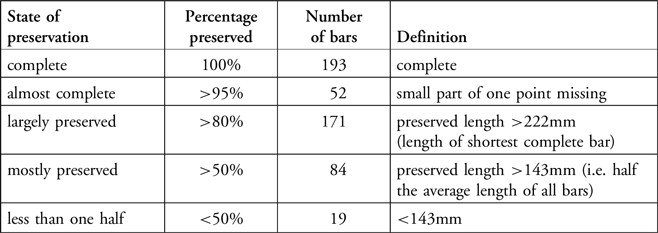
The 540 fragments were systematically examined for matches, with the matching pieces receiving one inventory number (1–519). The minimum number of bars, based on specimens where more than half of the bar is preserved, is exactly 500 (Table 1).
State of preservation of the Deinham bars.

Table 1 Long description
The table has five rows and four columns. The columns are labeled State of preservation, Percentage preserved, Number of bars, and Definition. The rows are as follows: Row 1: State of preservation, complete; Percentage preserved, 100 percent; Number of bars, 193; Definition, complete. Row 2: State of preservation, almost complete; Percentage preserved, more than 95 percent; Number of bars, 52; Definition, small part of one point missing. Row 3: State of preservation, largely preserved; Percentage preserved, more than 80 percent; Number of bars, 171; Definition, preserved length more than 222 millimeters (length of shortest complete bar). Row 4: State of preservation, mostly preserved; Percentage preserved, more than 50 percent; Number of bars, 84; Definition, preserved length more than 143 millimeters (i.e. half the average length of all bars). Row 5: State of preservation, less than one half; Percentage preserved, less than 50 percent; Number of bars, 19; Definition, less than 143 millimeters.
Many of the iron finds exhibit adherent gravel and sand (Figure 3). Of the 193 complete bars, 83 have gravel covering more than approximately 20 per cent of their surface, 45 show gravel over less than around 20 per cent of their surface and 65 are free of adhesions, the result of ‘cleaning’ by the gravel crusher. The adherent sediments are not uniform, with a mixed composition of grain sizes varying from sand to coarse gravel (20–63mm). All objects are heavily corroded on the surface and display a variety of iron oxide colours (from medium brown to reddish brown to dark brown and dark grey/black).
Top) one iron bar from Deinham with adhering gravel; middle & lower) two other bars that were ‘cleaned’ by the gravel crusher (figure by Peter Trebsche).

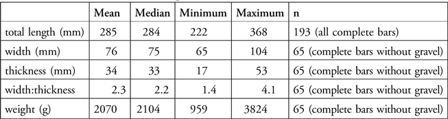
The average length of the complete bars (n = 193) is 285mm, with a minimum of 222mm and a maximum of 368mm (Table 2). Almost all of the complete bars have a rectangular cross-section; only a few pieces have slightly convex sides. Cross-sectional proportions vary from short rectangular to long rectangular: 23 objects are approximately twice as wide as they are thick; 36 are three times as wide as thick; five are four times as wide as thick; and one bar is more than four times as wide as thick. The average weight of the complete bars without gravel adhesion is 2070g, with a minimum of 959g and a maximum of 3824g (Table 2). The weight distribution of this assemblage shows several peaks between 1600 and 2400g, indicating that the bars were not all standardised by weight (Figure 4). The total weight of all preserved fragments including adherent gravel is 1065kg. Given the minimum number of 500 bars and accounting for the fact that some fragments are missing, the original iron weight for the full assemblage (without gravel) can be estimated at around 1035kg.
Measurements of iron semi-products from Deinham.

Table 2 Long description
A table with six rows and five columns comparing various measurements of iron semi-products. The columns are labeled Mean, Median, Minimum, Maximum, and n. The rows are labeled total length (mm), width (mm), thickness (mm), width:thickness, and weight (g). Row 1: total length (mm): Mean, 285; Median, 284; Minimum, 222; Maximum, 368; n, 193 (all complete bars). Row 2: width (mm): Mean, 76; Median, 75; Minimum, 65; Maximum, 104; n, 65 (complete bars without gravel). Row 3: thickness (mm): Mean, 34; Median, 33; Minimum, 17; Maximum, 53; n, 65 (complete bars without gravel). Row 4: width:thickness: Mean, 2.3; Median, 2.2; Minimum, 1.4; Maximum, 4.1; n, 65 (complete bars without gravel). Row 5: weight (g): Mean, 2070; Median, 2104; Minimum, 959; Maximum, 3824; n, 65 (complete bars without gravel).
Weight distributions of the complete iron bars from Deinham (figure by Peter Trebsche).

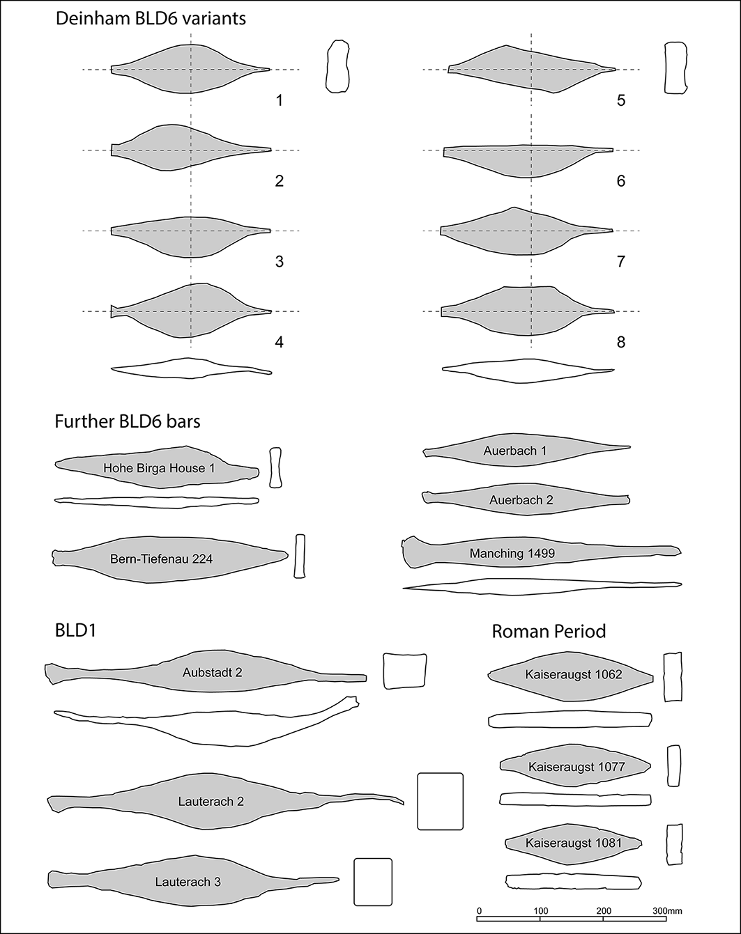
All bars have a double-pointed shape, though several variants can be distinguished (Figures 5 & 6). Most bars are elongated and willow leaf-shaped; these are either completely symmetrical (variant 1), slightly asymmetrical in the longitudinal axis (variant 2), slightly asymmetrical in the transverse axis (variant 3) or have a shoulder on one side (variant 4). Some bars are shaped like a parallelogram (variant 5) or have a curved (convex) side in combination with either a straight side (variant 6), a single-peaked side (variant 7) or a double-peaked side (variant 8).
A selection of typical bars from Deinham (figure by Andreas Blaickner and Markus Staudt, Institut für Archäologien, Universität Innsbruck).

Classification scheme of semi-products from Deinham according to shape (variants 1–8) and comparable bars of the BLD6, BLD1 and Roman period types (figure by Peter Trebsche; Bern-Tiefenau after Müller Reference Müller1990: pl. 27/224; Manching after Jacobi Reference Jacobi1974: pl. 76; Auerbach-Maximiliansfelsen after Mühldorfer Reference Mühldorfer2015: fig. 11; Birgitz-Hohe Birga after Gleirscher Reference Gleirscher1987: fig. 17/8).

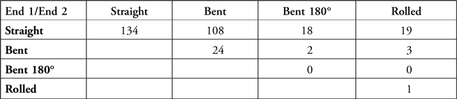
The bars were forged to be pointed, blunt or flat at each end; most display one pointed and one flat end (Table 3). Most ends are straight, though some are bent upwards or bent over at 180°, and a small number are rolled inwards (Table 4).
Combination of end forms of the Deinham bars (n = 196).

Table 3 Long description
A table showing the combination of end forms of Deinham bars. The table has three rows and four columns. The row labels are Pointed, Blunt, and Flat. The column headers are End 1/End 2, Pointed, Blunt, and Flat. Row 1: End 1/End 2, Pointed, 5; Blunt, 26; Flat, 121. Row 2: End 1/End 2, Blunt, 11; Blunt, 12; Flat, 21. Row 3: End 1/End 2, Flat.
Combination of end deformations of the Deinham bars (n = 309).

Table 4 Long description
A table comparing the deformations of the ends of Deinham bars. The table has four rows and four columns. The row labels are Straight, Bent, Bent 180 degrees, and Rolled. The column headers are Straight, Bent, Bent 180 degrees, and Rolled. Row 1: Straight, Straight 134, Bent 108, Bent 180 degrees 18, Rolled 19. Row 2: Bent, Straight 24, Bent 2, Bent 180 degrees 3, Rolled 3. Row 3: Bent 180 degrees, Straight 0, Bent 0, Bent 180 degrees 0, Rolled 0. Row 4: Rolled, Straight 0, Bent 0, Bent 180 degrees 0, Rolled 1.
Typological and metric analysis
The iron bars from Deinham can be classified as bipyramidal or double-pointed semi-products. These are sometimes labelled as ‘ingots’ but this term is not appropriate as the bars are forged, not cast (Kleemann Reference Kleemann1961, Reference Kleemann1981; Jacobi Reference Jacobi1974: 248–50; Kurz Reference Kurz1995: 16–21; Pleiner Reference Pleiner2006: 23–32; Senn et al. Reference Senn, Cech and Rehren2014; Berranger Reference Berranger2014). Similarly shaped semi-products have been found in Mesopotamia, for example in Nimrud or Susa. Perhaps the most famous find was discovered in Khorsabad (Dur Šarrukin) in Iraq, built as the Assyrian capital under the rule of Sargon II from 712 to 706 BC. Excavation of a storage room uncovered allegedly 160 tonnes of iron objects, including perforated bipyramidal semi-finished objects measuring 320–480mm in length and weighing 3.48–8.76kg each (Place Reference Place1867: 84–88, pl. 71/5–7; Pleiner Reference Pleiner1979). Like the Khorsabad specimens, bipyramidal semi-products from the Near East often have a hole, which allowed them to be tied together with a string, a feature not present in most European examples.
In Europe, most double-pointed semi-products have been discovered without datable contexts. They are typically found in the Middle Rhine region, especially in the Hunsrück and Palatinate, as well as in Württemberg, Bavaria and northern Switzerland, though scattered finds cover a much larger area, extending as far as western France and England, along the Danube to Austria, Czechia, Slovakia and Hungary, and in the Alps to South Tyrol (cf. Jacobi Reference Jacobi1974: 250, fig. 57; Kurz Reference Kurz1995: 16, fig. 2; Berranger Reference Berranger2014: fig. 31). Recent attempts at radiocarbon dating have placed a series of almost twenty bars within the ‘Hallstatt plateau’, a level anomaly in the radiocarbon calibration curve between the eighth and fifth centuries BC, including one object that had been discovered in a pit belonging to the La Tène period (mid-fifth to first centuries BC) (Bauvais et al. Reference Bauvais and Brun2021; Berranger et al. Reference Berranger2021).
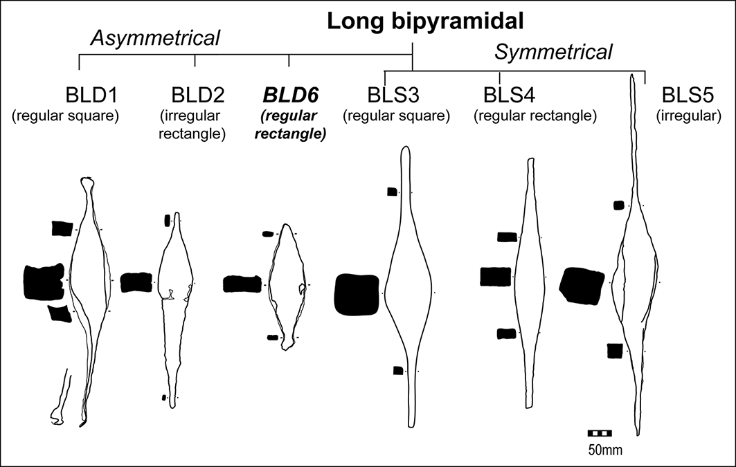
Previous studies have singled out a short, thick, heavy double-pointed semi-product type, sometimes called the ‘Colmar type’, with a length of 200–300mm and an average weight of 5.5–8kg, and divided it into several variants, the distributions of which were interpreted as the sales areas of different workshops (Kleemann Reference Kleemann1981; Senn et al. Reference Senn, Cech and Rehren2014). The bars from Deinham do not belong to this thick type; they represent a new variant (no. 6) of the highly variable BLD type (B = bipyramidal, L = long, D = asymmetrical) (Berranger Reference Berranger2014: 64–69, figs. 21 & 24). This new BLD6 variant is characterised by a regular rectangular cross-section and one flat end (Figure 7).
Updated classification of iron semi-products including the new BLD6 variant (figure by Marion Berranger).

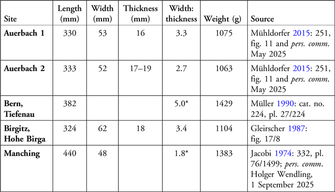
The Deinham semi-products have only few parallels (Table 5): one bar from the oppidum of Manching (Upper Bavaria, Germany; Jacobi Reference Jacobi1974: 248, pl. 76/1499), two specimens from Maximiliansfelsen near Auerbach (Upper Palatinate, Germany; Mühldorfer Reference Mühldorfer2015: 251, fig. 11) and one bar from Hohe Birga in Birgitz (Tyrol, Austria; Gleirscher Reference Gleirscher1987: fig. 17/8) could also belong to the BLD6 variant. Given their settlement context, the Manching and the Birgitz bars date from the Middle to Late La Tène period (mid-third to first centuries BC) (Gleirscher Reference Gleirscher1987; Sievers Reference Sievers2003). One unique semi-product from Tiefenau in Bern (Switzerland), attributed to the LT C1 phase (second half of the third century BC), also looks similar to the Deinham bars, despite its very long rectangular cross-section (Müller Reference Müller1990: 65, 152, no. 224, pl. 27/224).
Measurements of previously identified individual BLD6 semi-products.

Table 5 Long description
The table presents measurements of BLD6 semi-products from various sites. It includes six rows and seven columns. The columns are labeled Site, Length (mm), Width (mm), Thickness (mm), Width: thickness, Weight (g), and Source. The rows list data for each site: Auerbach 1, Auerbach 2, Bern Tiefenau, Birgitz Hohe Birga, and Manching. Each row provides specific measurements and sources for the semi-products. Notable trends include variations in length, width, thickness, width-to-thickness ratio, and weight across different sites.
*Calculated from published drawing.
Scatterplots of metric characteristics (Figure 8) show the variability of the Deinham semi-products and other BLD6 specimens. These can be differentiated in the plots from other semi-products of the BLD1 and BLD2 types, some of which also show one flat end. Inclusion of semi-products from a Roman trading depot in Kaiseraugst-Schmidmatt (canton of Aargau, Switzerland) from the end of the third century AD shows that there are similarities with the BLD6 variant in term of dimensions. However, the Roman period specimens are plate-shaped and have two edges perpendicular to the longitudinal axis at the ends, representing a distinct type (Wyss & Wyss Schildknecht Reference Wyss and Wyss Schildknecht2022: 273–79; cf. Senn et al. Reference Senn, Cech and Rehren2014: 149).
Metric analysis of BLD1, BLD2 and BLD6 semi-products. Data source: for BLD6 see Table 5, for other types see Kleemann Reference Kleemann1966 (Aubstadt); Szabó Reference Szabó1966 (Dunaújváros); Wyss & Wyss Schildknecht Reference Wyss and Wyss Schildknecht2022 (Kaiseraugst); Menghin Reference Menghin1937: 17 no. 26; 23 no. 73 (Lauterach and “Vorarlberg”); Lelong Reference Lelong1991 (Nottonville); Degen Reference Degen1957: 115–16, fig. 46 (Splügen) (figure by Peter Trebsche).

Radiocarbon dating
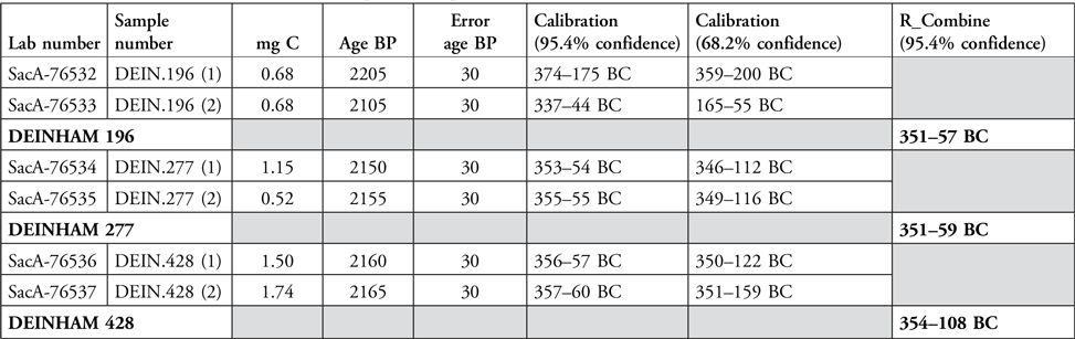
Iron objects may be radiocarbon dated by measuring the carbon isotopes trapped in the cementite of the metallic matrix (Leroy et al. Reference Leroy2015). Three bars were selected from the Deinham assemblage based on their typical form and dated using this approach. Sections were cut from each bar, polished and etched with 4% Nital, then metallographic microscopy was used to identify the most carburised areas on each section. Metal particles were collected from these areas via micro-drilling. Two samples were taken from each bar to check the reliability of the radiocarbon measurements. Carbon was extracted from the metal by combustion and analysed using accelerator mass spectrometry at the Laboratoire de Mesure du Carbone 14 (University of Paris-Saclay). Dates were calibrated with OxCal v.4.4 using the IntCal20 calibration curve (Reimer et al. Reference Reimer2020; Bronk Ramsey Reference Bronk Ramsey2021).
As two measurements were obtained for each object, the R-Combine tool in OxCal was used to generate a single age probability distribution per bar; this is particularly useful for refining the archaeological timescale during periods of pronounced radiocarbon fluctuations. The R-Combine tool requires overlapping date intervals that pass the Chi-square test. Although this was not strictly the case with one bar (Deinham 196, where the two dates are slightly consecutive), the dates fell within the same range as the others.
The results (Table 6) are highly consistent. The 95.4% confidence R-Combine ranges for Deinham 196 and 277 are similar, spanning 351 to 57/59 cal BC, while Deinham 428 shows a slightly narrower range, from 354–108 cal BC. This result closely aligns with the calibration obtained for all three bars at the 68.2% confidence level.
Radiocarbon dates made on the steely part of samples from three iron bars from Deinham.

Table 6 Long description
The table presents radiocarbon dates and calibrations for samples from three iron bars from Deinham. It has 12 rows and 8 columns. The columns are labeled as Lab number, Sample number, mg C, Age BP, Error age BP, Calibration (95.4% confidence), Calibration (68.2% confidence), and R_Combine (95.4% confidence). The row labels include SacA-76532, SacA-76533, DEINHAM 196, SacA-76534, SacA-76535, DEINHAM 277, SacA-76536, SacA-76537, and DEINHAM 428. The table provides specific values for each sample, including the lab number, sample number, mg C, age in BP, error age in BP, and calibration ranges at different confidence levels. Notable trends include the consistent calibration ranges for Deinham 196 and 277, spanning 351 to 57/59 cal BC, while Deinham 428 shows a slightly narrower range, from 350 to 108 cal BC.
Overall, the data indicate two probability peaks: the first in the second half of the fourth century BC, and the second from the end of the third to the second century BC (Figure 9). Only the latter interval is consistent with the dates provided by the archaeological contexts of other BLD6 bars (see above). These new dates demonstrate that the Deinham-type bar was produced substantially later than the thicker and shorter semi-products found west of the Rhine, which are dated to the period between the eighth and fifth centuries BC.
Radiocarbon dates for three iron bars from Deinham. Calibration model created with OxCal v.4.4.4 (figure by Marion Berranger).

Water transport and its risks
Like the mass find from Deinham, many other iron objects in Central Europe originate from (former) watercourses. Most studies on river finds have concluded that iron bars are losses incurred during transport, cargo that sank in shipwrecks and could not be recovered (Torbrügge Reference Torbrügge1970–1971: 53–56; Kurz Reference Kurz1995: 104). The possibility of ritual deposition cannot be excluded, but the homogeneous semi-product assemblage from Deinham differs considerably from the more varied composition of ritual river deposits, such as those found at La Tène and Port in Switzerland (Müller Reference Müller1990). Moreover, Late Iron Age river finds are generally rare in the Eastern La Tène Culture (Schönfelder Reference Schönfelder and Barral2007), so the Deinham assemblage does not fit into the established regional pattern of ritual behaviour.
Until the advent of the railway, waterways were the preferred means of transporting heavy goods. During the La Tène period, the major rivers of Central Europe likely hosted regular, well-organised shipping traffic (Ellmers Reference Ellmers and Gardiner1996; Wieland 2000/Reference Wieland and Röber2001; Salač Reference Salač2007). Inland waterway transport is evidenced by Late Iron Age dugouts from Austria (Pohl Reference Pohl2006), Bavaria (Pflederer Reference Pflederer2009) and Czechia (Rogers Reference Rogers2010). A logboat can carry well over a tonne of cargo (Rogers Reference Rogers2010: 318) and larger loads can be transported on rafts, plank boats or logboats tied together (Pflederer Reference Pflederer2009). The robust dugouts are well represented among finds recovered from waterlogged contexts, while plank boats are much rarer due to their fragility (Ellmers Reference Ellmers and Gardiner1996). A miniature gold ship from grave 44/1 at Dürrnberg provides key evidence for the use of plank boats in the La Tène period (Wendling Reference Wendling2018).
There is no trace of a watercraft associated with the semi-products from Deinham, which is not unexpected given that the finds were recovered with the excavator. However, given the location of the find and the size of the assemblage, it is highly likely that the iron bars were being transported along the river. Though the means of transport would not be unconventional for the LT C2/D1 period, the large quantity of iron that was available for a single transaction, probably in the second century BC, is unusual based on current evidence.
Weight comparisons
Comprising at least 500 iron semi-products together weighing more than one tonne, the Deinham mass find is the most abundant assemblage of Iron Age bars currently known in Europe. It far outweighs the Hallstatt period (eighth–mid-fifth centuries BC) iron bars from Durrenentzen (Haut-Rhin department, France) where 51 bipyramidal semi-products of the short BCS2 variant with a total weight of 308.5kg were found in a terrestrial context (Berranger Reference Berranger2014: 236, no. 4.9; Bauvais et al. Reference Bauvais2018). Other iron deposits are reported to contain a maximum of approximately 40–60 bipyramidal bars, for example from Bechtheim (district of Alzey-Worms, Germany; 60 pieces; Kurz Reference Kurz1995: no. 88), Huttenheim (district of Karlsruhe, Germany; 45 pieces totalling around 250kg; Kurz Reference Kurz1995: 104, 151, no. 398) or Veckersviller (Moselle department, France; 56 BLS4 bars, 128kg; Berranger Reference Berranger2014: 239, no. 4.26).
Irrespective of the practices underlying the depositional patterns, the combined weight of the Deinham trove provides direct evidence for the capacities of Middle and Late La Tène period iron production. Compared with the Hallstatt and Early La Tène period, the scale of iron production rose during the third century BC (Berranger & Bauvais Reference Berranger and Bauvais2020), before a further increase during the second century BC, which is reflected in the abundance of iron objects in all settlement categories, from single farms to oppida. The mass find at Deinham adds to this body of evidence for increased iron production during the third and second centuries BC.
The value and equivalence of iron
The value of the iron semi-products found at Deinham can be approximated based on its potential use. Around one tonne of iron is enough to forge approximately 500 swords with an average weight of 1.5–2kg. Even taking material losses during manufacture into account, the iron from Deinham is sufficient to equip a large group with weapons. Alternately, up to 8000 iron nails (weighing 125g each) could be produced. These nails could be used for the construction of a murus Gallicus defensive wall, to secure the wooden framework, and the iron from Deinham is sufficient to have nailed down almost half of the 7km-long wall around Manching (cf. Köhler & Maier Reference Köhler, Maier and Maier1992: 350). One tenth of the Deinham iron would have provided the nails to fix the entire wooden framework in the southern wall on the Gründberg in Linz, the nearest oppidum on the Danube (some 29km east; Trebsche Reference Trebsche2020: 106, fig. 3.44). Four iron depots weighing a total of ‘only’ 60kg were encased in this fortification wall (Urban & Ruprechtsberger Reference Urban and Ruprechtsberger2019; Trebsche Reference Trebsche2020: 451–53, figs. 16.11–16.14); thus, the cargo at Deinham was more than 17 times the amount of iron that was sacrificed at Gründberg during the construction of the wall, further emphasising its volume and value.
Consideration of transport logistics can also provide a hypothetical equivalent value for a tonne of iron. Even if the exact exchange value cannot be quantified, it is clear that most potential exchange goods could not be transported back (upstream) to the iron producers, due to their volume or mass (this applies, for example, to grain, non-ferrous metals, salt and wine). Other exchange items were unlikely to have been available in sufficient quantities to trade against one tonne of iron in a single transaction (e.g. raw glass or glass artefacts, imported Mediterranean tableware, coral and amber). Given the limitations in transport, only three possibilities remain: either an immaterial return was provided (dowry, tribute, military service), the exchange item was itself mobile (slaves, cattle, horses) or the iron cargo was paid for with a much more valuable metal (gold or silver).
Celtic coinage appeared in the Bavarian and Upper Austrian Danube region around the Middle La Tène period (second century BC), making more regular economic transactions of this magnitude possible (Ziegaus Reference Ziegaus and Karwowski2015). Upper Austria was part of the Bavarian economic zone, as evidenced by the high proportion of South Bavarian coins found in the large settlement agglomeration of Neubau near Linz (Prokisch & Leskovar Reference Prokisch, Leskovar and Ramsl2019). Coins were available in large quantities, as numerous coin hoards demonstrate (cf. Ziegaus Reference Ziegaus and Karwowski2015: 360, tab. 1), and therefore also for large-scale transactions. The gold-coin hoard from the oppidum of Manching (443 coins, totalling 3.7kg of gold) or the hoard from Großbissendorf in the Upper Palatinate (384 gold coins) might plausibly have been equivalent in value to a tonne of iron—both were, incidentally, found near large iron mining areas (see below). The iron semi-products from Deinham could therefore represent the first equivalent to a large coin hoard identified in the La Tène period, contributing to ongoing debate about the purchasing power of such hoards (e.g. Nick Reference Nick2006; Ziegaus Reference Ziegaus and Karwowski2015: 363, 371–72; Schußmann Reference Schußmann2019: 306–8). The Deinham find perfectly illustrates the increasing scale of production and trade that was facilitated, or perhaps even provoked, by the monetarisation of socioeconomic relations in the La Tène Culture from the third century BC onwards (Hiriart et al. Reference Hiriart and Pierrevelcin2020).
Open questions: provenance and production
While the primary destination of the iron bars remains unknown, several assumptions can be made concerning the provenance of the iron and the location of the forge in which the iron blooms were transformed into semi-products. As a premise, water transport from the site of production can only have taken place downstream; the region of production must therefore be sought upstream on the Danube or one of its tributaries. For this reason, the La Tène period iron-production districts further east, especially those in Burgenland in eastern Austria, where huge fields of mining pits indicate extensive iron production, can be ruled out (Trebsche Reference Trebsche2020: 243–51).
Upstream on the Danube, in Bavaria, there were several iron-smelting districts in operation during the La Tène period that could have produced the raw material for the semi-products from Deinham (Figure 10). The nearest iron-production site was located close to the oppidum of Kelheim, about 220km along the length of the river above Deinham. This oppidum benefitted from the vast iron deposits in the Upper Palatinate, where a large La Tène period settlement with evidence for intensive iron processing developed near Berching-Pollanten (Schäfer Reference Schäfer and Dobiat2002).
Map showing the site of Deinham (red dot), the find spots of other BLD6-type semi-products (white dots) and La Tène period iron production districts (grey areas): 1) Markgräfler Land; 2) Rothtal 3) Zusamaltheim; 4) Donau- and Feilenmoos; 5) Ingolstadt-Etting; 6) region of Kelheim (figure by Peter Trebsche; basemap: OpenStreetMaps; iron production districts after Gassmann & Schäfer Reference Gassmann, Schäfer, Cech and Rehren2014: fig. 4).

Further west, iron was produced in the vicinity of Manching (in the Donaumoos and Feilenmoos), as well as in Etting near Ingolstadt and in the Donauried near Dillingen in northern Swabia. There is also evidence of La Tène period iron smelting in the Roth Valley in Bavarian Swabia, south of the Danube (Gassmann & Schäfer Reference Gassmann, Schäfer, Cech and Rehren2014). Central-eastern France (Berranger et al. Reference Berranger2023) can also be regarded as a potential area of origin, as combined water and land transport should also be considered. However, as some BLD6 bars of the Deinham type have previously been found in the area between Manching, Kelheim and the Upper Palatinate (Figure 10), it seems most plausible that the Deinham bars were forged in this region.
Trace element analyses of selected semi-products from Deinham are currently underway and should provide a clearer indication of raw metal supply sources. Ongoing metallographic investigations will also help clarify whether all bars were produced in a single workshop or according to a standardised tradition. Both analyses will provide new insights into the technology and organisation of trade in the La Tène period. For example, does the appearance of the BLD6 variant reflect a change in production? Data from the Deinham mass find could also help us understand why the weight of iron bars decreased by a magnitude of three or four in the La Tène period compared to the preceding Hallstatt period. This tendency can also be observed with the emergence of currency bars in the fifth/fourth century BC (Berranger et al. Reference Berranger2021). The mass find from Deinham will thus contribute to multiple ongoing discussions regarding the primary metal resource of the Late Iron Age.
Conclusion
An assemblage of at least 500 bipyramidal iron bars was unearthed in 2019 during gravel extraction work in Deinham, on the right bank of the Danube in Upper Austria. Though morphologically variable, these bars can be classified as iron semi-products and a new variant of the BLD type (no. 6). With an estimated combined weight of 1035kg, the scale of this find is unprecedented, providing sufficient iron to outfit approximately 500 warriors with swords or to produce enough nails to construct half of the defensive wall around Manching. With work to establish the provenance of the iron underway, the Deinham mass find provides further evidence for the increasing scale of iron production in the third and second centuries BC and contributes to our growing understanding of production and trade in the La Tène period of Central Europe.
Acknowledgements
Our thanks go to the finders and former owners of the Deinham finds for their co-operation and generous donation; to Heinz Gruber from the Federal Monuments Office in Linz for his kind information; to Jutta Leskovar from Oberösterreichische Landes-Kultur GmbH in Linz and to the University of Innsbruck for funding the archaeometric analyses; to Holger Wendling from the Archäologische Staatssammlung in Munich for providing the weight of the Manching semi-product; to Bernd Mühldorfer, Nürnberg, for information and measurements of the bars from Auerbach; to the LMC14 for the radiocarbon dating of the bars; to the reviewers for their helpful comments; and, last but not least, to Isabella Prackwieser, Andreas Blaickner and Markus Staudt from the Department of Archaeologies at Innsbruck University for the tedious documentation of hundreds of iron bars.
Funding statement
This research was funded by the University of Innsbruck and the Oberösterreichische Landes-Kultur GmbH.
Author contributions: CRediT categories
Peter Trebsche: Conceptualization-Lead, Data curation-Equal, Formal analysis-Equal, Funding acquisition-Equal, Investigation-Equal, Methodology-Equal, Visualization-Equal, Writing - original draft-Lead, Writing - review & editing-Equal. Marion Berranger: Data curation-Equal, Formal analysis-Equal, Investigation-Equal, Methodology-Equal, Visualization-Supporting, Writing - original draft-Supporting, Writing - review & editing-Equal.









 Open access

