INTRODUCTION
A key unresolved question is the timing, rate, and main hydrologic changes that accompanied the last glacial interglacial transition in Patagonia (18–11.5 ka). This period, known as the last termination (cf. Denton et al., Reference Denton, Anderson, Toggweiler, Edwards, Schaefer and Putnam2010), offers an opportunity to unravel the link between severe abrupt climate fluctuations and landscape response, teleconnections between mid- and high latitudes, and the forcing underlying climate change at the end of the last glaciation (Turner et al., Reference Turner, Fogwill, McCulloch and Sugden2005; Moreno et al., Reference Moreno, Denton, Moreno, Lowell, Putnam and Kaplan2015; Glasser et al., Reference Glasser, Jansson, Duller, Singarayer, Holloway and Harrison2016; Henríquez et al., Reference Henríquez, Villa-Martínez, Vilanova, De Pol-Holz and Moreno2017). During the last glacial maximum (LGM), the Patagonian Ice Sheet (PIS) built up to 500,000 km3 of ice and extended all the way along the southern Andes between 38°S and 55°S (Hulton et al., Reference Hulton, Purves, McCulloch, Sugden and Bentley2002). The glacial extent reached the Pacific Ocean basin to the west and the steppe plains to the east (more than 100 km from the current ice source). After the LGM, the PIS retreated into the Andes (McCulloch et al., Reference McCulloch, Bentley, Purves, Hulton, Sugden and Clapperton2000), where only the Northern and Southern Patagonian Ice Fields together with sparse ice caps topping high mountains remain (Barcaza et al., Reference Barcaza, Nussbaumer, Tapia, Valdés, García, Videla, Albornoz and Arias2017). To date, we lack a complete understanding of the PIS retreat and landscape transformation during the last deglaciation, including the timing and rate of ice demise, deglacial paleolake formation and collapse, and continental scale drainage diversion. Whereas some works suggest large and abrupt ice retreat starting at ca.18 ka and reaching the Andes core as early as 16.5 ka, with no evidence for extensive late-glacial readvances (Mercer, Reference Mercer1976; Denton et al., Reference Denton, Lowell, Heusser, Schlüchter, Andersen, Heusser, Moreno and Marchant1999; Hall et al., Reference Hall, Porter, Denton, Lowell and Bromley2013, Reference Hall., Denton, Lowell, Bromley and Putnam2017; Moreno et al., Reference Moreno, Denton, Moreno, Lowell, Putnam and Kaplan2015), others suggest a stepped ice retreat including late-glacial readvances until the very end of the last glacial-interglacial transition (McCulloch et al., Reference McCulloch, Fogwill, Sugden, Bentley and Kubik2005; Sugden et al., Reference Sugden, Bentley, Fogwill, Hulton, McCulloch and Purves2005; Strelin et al., Reference Strelin, Denton, Vandergoes, Ninnemann and Putnam2011; García et al., Reference García, Kaplan, Hall, Schaefer, Vega, Schwartz and Finkel2012; Glasser et al., Reference Glasser, Harrison, Schnabel, Fabel and Jansson2012; Sagredo et al., Reference Sagredo, Kaplan, Araya, Lowell, Aravena, Moreno, Kelly and Schaefer2018). The onset of the PIS deglaciation is also debated: some Patagonian glaciers seem to have retreated from their maximum stands significantly earlier than others, which has implications for our understanding of the mechanisms of climate change during the last termination (Denton et al., Reference Denton, Lowell, Heusser, Schlüchter, Andersen, Heusser, Moreno and Marchant1999, Reference Denton, Anderson, Toggweiler, Edwards, Schaefer and Putnam2010; Sugden et al., Reference Sugden, Bentley, Fogwill, Hulton, McCulloch and Purves2005; Douglass et al., Reference Douglass, Singer, Kaplan, Mickelson and Caffee2006; Hein et al., Reference Hein, Hulton, Dunai, Kaplan, Sugden and Xu2010; de Porras et al., Reference De Porras, Maldonado, Abarzúa, Cárdenas, Francois, Martel-Cea, Stern, Méndez and Reyes2012; Moreno et al., Reference Moreno, Denton, Moreno, Lowell, Putnam and Kaplan2015; Henríquez et al., Reference Henríquez, Villa-Martínez, Vilanova, De Pol-Holz and Moreno2017). In this article, we discuss the geomorphic, stratigraphic, and geochronological deglacial record of the former Río Cisnes Glacier at 44°S in the Chilean Patagonian Andes (Fig. 1). We combine mapping techniques (e.g., glacial geomorphology and stratigraphy) with a composite dating approach including 10Be, 14C, and optically stimulated luminescence (OSL) dating to elucidate deglacial stages and former deglacial environments at Río Cisnes and surrounding basins, such as Río Toqui and Río Ñirehuao basins. Combining all data at the local and regional scale, we discuss the demise of the PIS and the associated chain of paleolakes and fluvial events that characterized the last glacial-interglacial transition at 44°S in southern South America. In addition, this work considers the characteristics of landscapes pertinent to the earliest human presence (Méndez et al., Reference Méndez, Delaunay, Reyes, Ozán, Belmar and López2018), which was one of the original motivations for this work (see archaeological information in the Supplementary Materials).
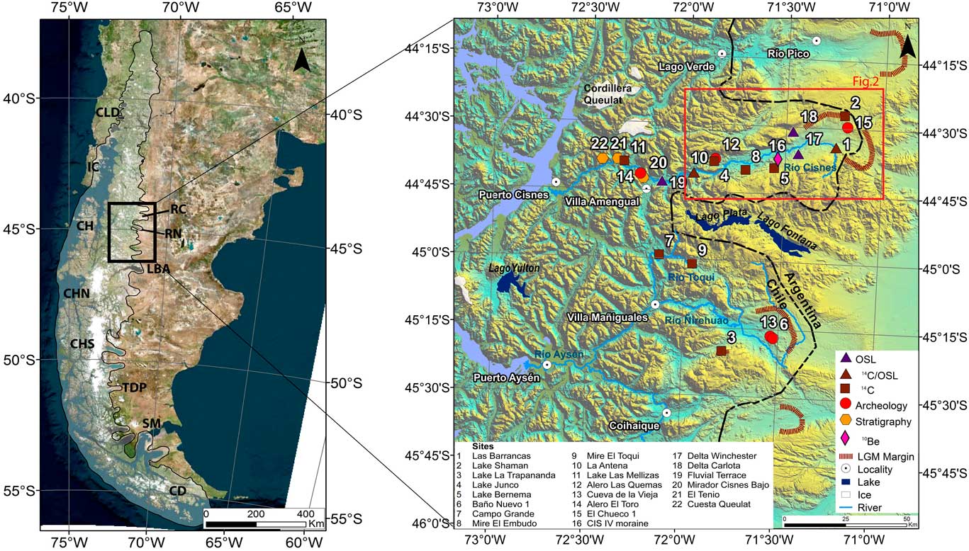
(color online) The Río Cisnes (RC) study area in the Patagonian physiographic context. The left panel shows southern South America and the approximate last glacial maximum (LGM) limit of the Patagonian Ice Sheet. CD, Cordillera Darwin; CH, Archipiélago de los Chonos; CHN, Campo de Hielo Norte; CHS, Campo de Hielo Sur; CLD, Chilean Lake District; IC, Isla de Chiloé; LBA, Lago Buenos Aires; RN, Río Ñirehuao; SM, Strait of Magellan; TDP, Torres del Paine. The right panel is a digital elevation model showing the study area and the sites examined by this work. Sites with chronological data reported by previous work, such as 1 (Stern et al., Reference Stern, de Porras and Maldonado2015), 2 (De Porras et al., Reference De Porras, Maldonado, Abarzúa, Cárdenas, Francois, Martel-Cea, Stern, Méndez and Reyes2012), 6 (Mena and Stafford, Reference Mena and Stafford2006), 8 (De Porras et al., Reference De Porras, Maldonado, Quintana, Martel-Cea, Reyes and Méndez2014), 4 and 11 (Weller et al., Reference Weller, de Porras, Maldonado, Méndez and Stern2017), and 12–15 (Méndez et al., Reference Méndez, Reyes, Velásquez and Maldonado2010, Reference Méndez, de Porras, Maldonado, Reyes, Nuevo Delaunay and García2016, Reference Méndez, Delaunay, Reyes, Ozán, Belmar and López2018), are also displayed. OSL, optically stimulated luminescence.

PHYSICAL SETTING
Patagonia includes the glacially scoured Pacific archipelagos and channels to the west, the southern Andean cordillera, and extensive sedimentary plains with glacial and glaciofluvial landforms to the east (Fig. 1). Outside Antarctica, it is the only continent in the Southern Hemisphere reaching beyond 46°S that intersects the core of the southern westerly wind belt. Its topographic structure determines a marked west-to-east precipitation gradient that results from forced air mass subsidence on the lee side of the Andes, with precipitation ranging from 3500 mm in the west to 450 mm close to the Chile-Argentina border (Garreaud et al., Reference Garreaud, Vuille, Compagnucci and Marengo2009). Westerly wind transported storms are associated with elevated precipitation levels on the ice fields (6–10 m per year; r; Escobar et al., Reference Escobar, Vidal, Garin and Naruse1992) and low temperatures that directly affect local climate and ice mass balance (e.g., Rivera et al., Reference Rivera, Acuña, Casassa and Bown2002).
The former Río Cisnes Glacier (Fig. 1) formed after numerous cirque ice sources coalesced from the main cordillera and expanded eastward. It also received local mountain ice from the easternmost glaciated Andes highlands (<2000 meters above sea level [m asl]), where the actual Río Cisnes originates (Fig. 2). Today, only small glaciers remain in the basin. The closest ice cap occurs on the Queulat Cordillera (~2100 m asl), 25 km north of Río Cisnes, at the highest Andean topographic divide. The Northern Patagonian Ice Field is 200 km south, at 46°S (Fig. 1). Río Cisnes Glacier deposited the LGM moraines at the easternmost end of the Río Cisnes basin, which today represent the international Chile-Argentina border and the continental water divide (De Porras et al., Reference De Porras, Maldonado, Abarzúa, Cárdenas, Francois, Martel-Cea, Stern, Méndez and Reyes2012). The Río Cisnes flows westward into the Pacific Ocean, first through a semiopen steppe land (upper Río Cisnes) and then through steep mountains that reach ~1500 m asl, above the treeline (lower Río Cisnes). This marked east–west vegetation sequence (grass steppe, deciduous Nothofagus forest, evergreen Nothofagus forest) between upper and lower Río Cisnes basin mimics the steep precipitation gradient (De Porras et al., Reference De Porras, Maldonado, Abarzúa, Cárdenas, Francois, Martel-Cea, Stern, Méndez and Reyes2012). At lower Cisnes, glacially scoured bedrock mantled by a dense evergreen forest makes a detailed glacial landscape inspection difficult. In this regard, therefore, roadside sediment sections represent an important source of data.
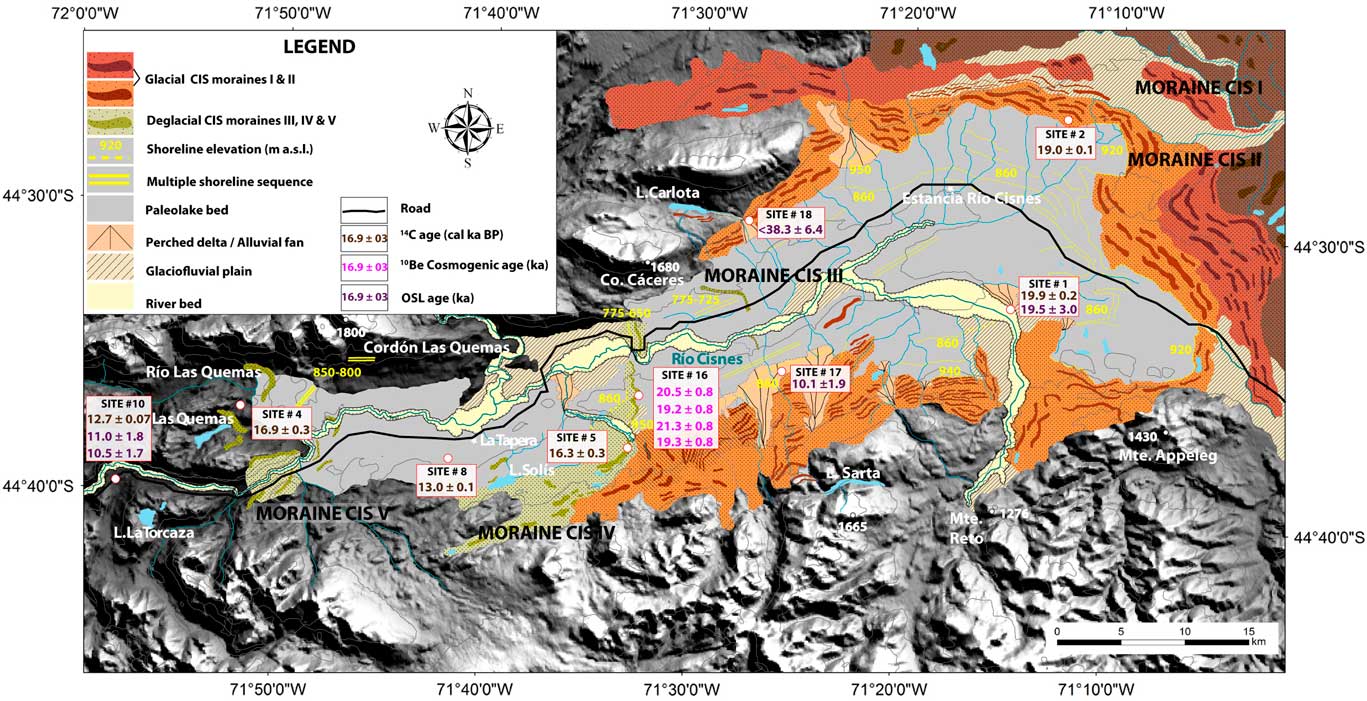
(color online) Glacial and deglacial geomorphic features of the upper Río Cisnes (CIS) basin. Note the east–west spatial distribution of moraine belts indicating former ice marginal positions. The map shows dates obtained through 14C, 10Be, and optically stimulated luminescence (OSL) chronometers in this study. Color of ages within white boxes identifies the dating technique used. Also shown are dates obtained previously: site 2 and site 8 have been published before by De Porras et al. (Reference De Porras, Maldonado, Abarzúa, Cárdenas, Francois, Martel-Cea, Stern, Méndez and Reyes2012, Reference De Porras, Maldonado, Quintana, Martel-Cea, Reyes and Méndez2014), respectively. The site 1 14C calibrated age is from Stern et al. (Reference Stern, de Porras and Maldonado2015). The site 4 14C calibrated age is from Weller et al. (Reference Weller, de Porras, Maldonado, Méndez and Stern2017).

The Río El Toqui and Río Ñirehuao valleys (45°S) are located south of Río Cisnes. Both rivers flow toward the Pacific Ocean through the Andean mountains. As evidenced by well-polished rocks and moraine belts on their eastern margins, the El Toqui and Ñirehuao valleys were covered by the PIS during the LGM. At their middle sections, widespread small lakes and peat bogs occur within enclosed rock basins.
METHODS
Geomorphology
Mapping of the study area was carried out by stereoscopic analysis of aerial photographs (GEOTEC, 1:70.000), as well as a detailed study of topographic maps and Quickbird satellite images (i.e., Google Earth imagery). The preliminary geomorphic map was checked and improved during multiple field campaigns in the study area between 2013 and 2017 (Fig. 2). In the field, we mapped glacial landforms (e.g., moraine ridges) and postglacial features including glaciolacustrine terraces, hanging deltas, beach berms, and fluvial terraces. Whenever possible, we described and dated sediment stratigraphic sections. Elevations of different features (e.g., paleolake shorelines) were measured several times using handheld global navigation satellite system (GNSS) (vertical precision±~10 m) and Quickbird satellite images. We used two different GNSS to obtain more accurate measurements. We constructed our geomorphic maps and defined the extent of paleolakes using ArcGIS version 10.3.
Chronology
We used three different but complimentary chronological techniques applied to different geomorphic and sedimentologic settings.
14 C radiocarbon dating
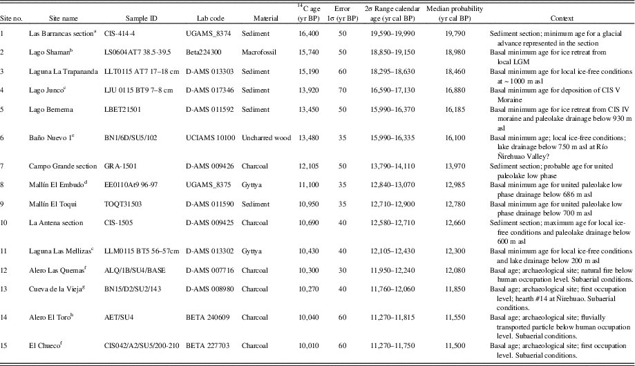
We 14C dated basal organic sediments in lakes (i.e., lago, laguna) and mires (i.e., mallín), which were obtained using a Wright modified Livingstone piston corer. Our 14C dating allows us to broaden the glaciological and climatological context beyond the Río Cisnes basin. We also 14C dated organic remains (e.g., charcoal) embedded into sedimentary stratigraphic sections that we compare with published records within the Cisnes basin (De Porras et al., Reference De Porras, Maldonado, Abarzúa, Cárdenas, Francois, Martel-Cea, Stern, Méndez and Reyes2012, Reference De Porras, Maldonado, Quintana, Martel-Cea, Reyes and Méndez2014; Stern et al., Reference Stern, de Porras and Maldonado2015; Weller et al., Reference Weller, de Porras, Maldonado, Méndez and Stern2017). Basal 14C ages obtained from archaeological sites (Méndez et al., Reference Méndez, Reyes, Velásquez and Maldonado2010, Reference Smedley, Glasser and Duller2016, Reference Méndez, Delaunay, Reyes, Ozán, Belmar and López2018) are used as relative markers for the studied stratigraphic sections to provide complementary chronological data also (Fig. 1, Table 1). All ages in this article are calibrated to calendar years at 2-sigma with the Southern Hemisphere curve (SHCal13; Hogg et al., Reference Hogg, Hua, Blackwell, Niu, Buck, Guilderson and Heaton2013) using CALIB 7.1.0 (Stuiver et al., Reference Stuiver, Reimer and Reimer2017) and are presented as the midpoint of the 2-sigma range as 14C cal ka BP (Table 1).
Reference Boulton 14 C radiocarbon samples, dates, and context. All sites from Río Cisnes except where indicated. See Figure 1 for site locations. CIS, (Cisnes); LGM, last glacial maximum; m asl, meters above sea level.

a Stern et al. (Reference Stern, de Porras and Maldonado2015).
b De Porras et al. (Reference De Porras, Maldonado, Abarzúa, Cárdenas, Francois, Martel-Cea, Stern, Méndez and Reyes2012).
c Weller et al. (Reference Weller, de Porras, Maldonado, Méndez and Stern2017).
d De Porras et al. (Reference De Porras, Maldonado, Quintana, Martel-Cea, Reyes and Méndez2014).
e Mena and Stafford (Reference Mena and Stafford2006).
f Méndez et al. (Reference Méndez, de Porras, Maldonado, Reyes, Nuevo Delaunay and García2016).
g Méndez et al. (Reference Méndez, Delaunay, Reyes, Ozán, Belmar and López2018).
h Méndez et al. (Reference Méndez, Reyes, Velásquez and Maldonado2010).
10 Be cosmogenic dating
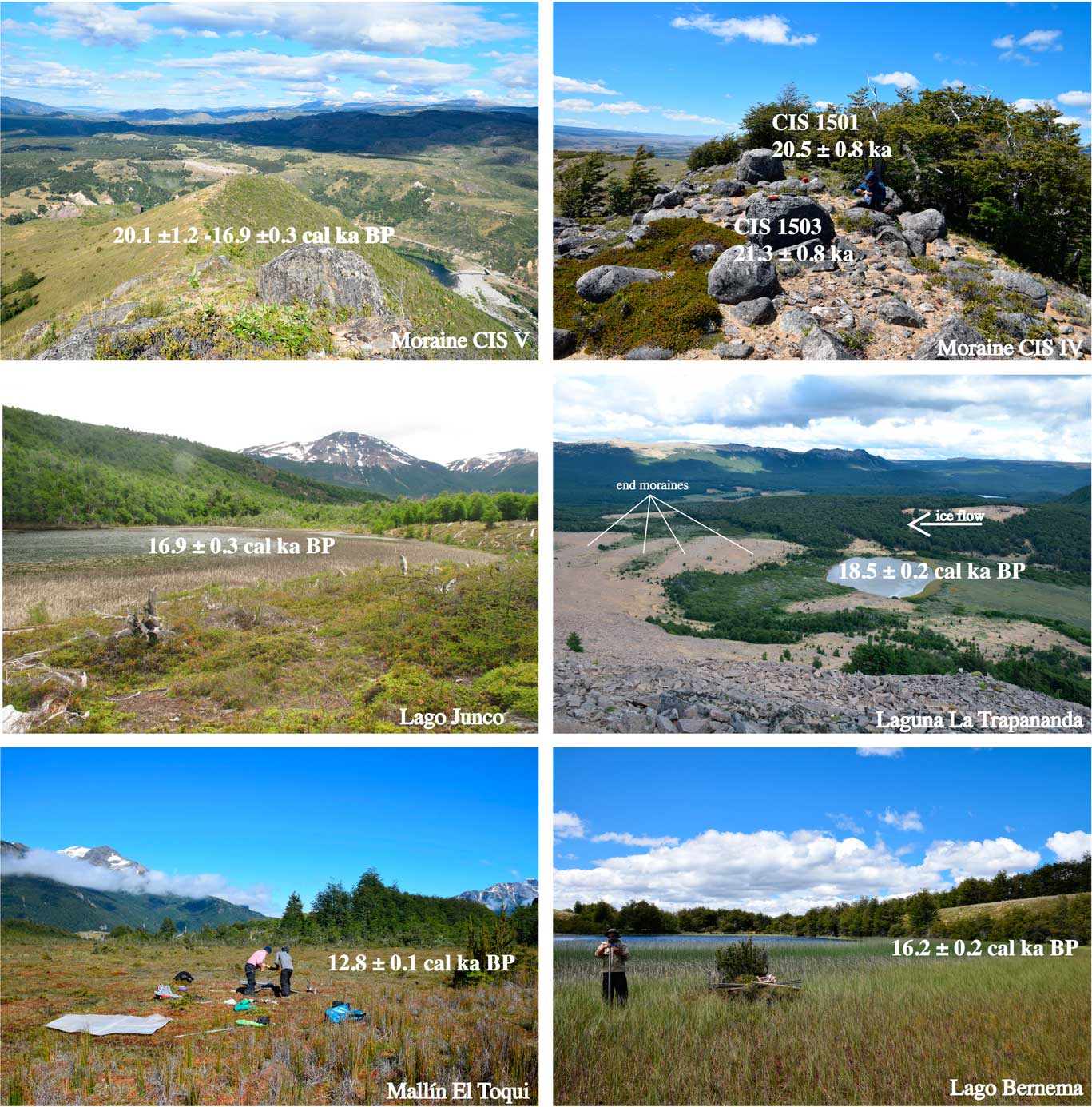
Using a hammer and chisel, we sampled four boulders resting in stable positions on the top of the Cisnes (CIS) IV moraine for cosmogenic 10Be analysis (Figs. 2 and 3). Boulders were granitic, and all of them were located in the same sector of the moraine, south of Río Cisnes at elevations ≥950 m, above any potential paleolake level that could have perturbed their postdepositional boulder exposure history. We extracted clean quartz from whole rock samples at the Universidad Católica Cosmogenic laboratory facilities. Samples were prepared as accelerator mass spectrometry (AMS) targets following the single-step column procedure outlined in Binnie et al. (Reference Binnie, Dunai, Voronina, Goral, Heinze and Dewald2015) in Cologne University and measured at CologneAMS (Dewald et al., Reference Dewald, Heinze, Jolie, Zilges, Dunai, Rethemeyer and Melles2013), using the calibration standards prepared by Nishiizumi et al. (Reference Nishiizumi, Imamura, Caffee, Southon, Finkel and McAninch2007) (see the Supplementary Materials for more details). Concentrations are reported after the subtraction of reagent blanks, which were processed and measured in tandem with the samples and whose values were less than 2% of the total number of 10Be atoms measured. Uncertainties were derived by propagating the errors in the AMS measurements of the blanks and the samples along with a 1% uncertainty in the mass of 9Be in the carrier.

Exposure ages were determined using the online calculator of Balco et al. (Reference Balco, Stone, Lifton and Dunai2008) (version 3.0, version 3.0.3 of the constants file) and applying the local 10Be production rate (3.71±0.11atoms/g/yr; Kaplan et al., Reference Kaplan, Strelin, Schaefer, Denton, Finkel, Schwartz, Putnam, Vandergoes, Goehring and Travis2011). For the CIS IV moraine, we present the mean±1σ plus a 3% production rate uncertainty (after Kaplan et al., Reference Kaplan, Strelin, Schaefer, Denton, Finkel, Schwartz, Putnam, Vandergoes, Goehring and Travis2011). We assumed no erosion affected the samples during their exposure. We used standard atmospheric pressure and a rock density of 2.65 g/cm3 for calculating 10Be ages. Other inputs used in the online calculator are given in Table 2. We discuss ages using the LSDn scaling scheme (Lifton et al., Reference Lifton, Sato and Dunai2014), but this choice does not affect our conclusions (Table 3).
Analytical data of 10Be samples collected from the Cisnes (CIS) IV moraine (site 16) at the Río Cisnes valley. See Figure 1 for site locations. m asl, meters above sea level.

10Be ages for Cisnes (CIS) IV moraine (site 16) at Río Cisnes. See Figure 1 for site locations.

Note: CRONUS online calculator (version 3.0; Balco et al., Reference Balco, Stone, Lifton and Dunai2008) output of 10Be ages. “St” is the time-dependent scaling scheme of Stone (Reference Stone2000), “Lm” is the time-dependent version of the Stone/Lal scaling scheme (Lal, Reference Lal1991; Stone, Reference Stone2000), and “LSDn” is the time-dependent version of the Lifton et al. (Reference Lifton, Sato and Dunai2014) scaling scheme. In the article, we discuss ages using the LSDn scaling scheme rounded to three significant figures. Age uncertainties reported are 1σ internal (int), which includes analytical uncertainty, and external (ext), which includes additional uncertainties associated with production rate scaling (Balco et al., Reference Balco, Stone, Lifton and Dunai2008).
OSL dating
We OSL dated deglacial delta and glaciofluvial sand sediments at the upper and middle Río Cisnes to track deglacial and hydrologic changes during the last glacial-interglacial transition. The luminescence samples were delivered to the Vienna Laboratory for Luminescence dating (VLL) in closed, light-tight plastic cylinders. Additional sample material from the direct surroundings of the luminescence sampling spots was taken for radionuclide determination. All sample preparation was conducted at the VLL. Although cosmogenic exposure dating determines the point in time when landform surfaces formed and stabilized, and radiocarbon dating determines the point in time when a living organism died, luminescence dating techniques enable the determination of the point in time when a sediment was last exposed to daylight during transport and was subsequently buried and shielded from daylight during deposition. During transport and light exposure, the latent luminescence signal is optically bleached and reset to zero. Once buried, the luminescence signal starts to build up again, as minerals function as natural dosimeters, capable of storing energy (equivalent dose, D e [J/kg = Gy]) and preserving it over geologic time scales. The signal buildup is induced by naturally occurring ionizing radiation over time (dose rate [Gy/a]). In general, quartz and potassium-rich feldspar minerals are suitable for luminescence dating techniques. However, previous studies have shown that for fluvial and especially glaciofluvial sediments only very low percentages of quartz grains (commonly less than 5% reported, e.g., by Lüthgens et al., Reference Lüthgens, Böse and Preusser2011; in Chile, even less than 1% reported by Duller, Reference Duller2006; Glasser et al., Reference Glasser, Jansson, Duller, Singarayer, Holloway and Harrison2016) of grains show suitable luminescence signals. In addition, quartz from Patagonia has been shown to exhibit generally poor luminescence properties for dating purposes (Duller, Reference Duller2006; Glasser et al., Reference Glasser, Harrison, Ivy-Ochs, Duller and Kubik2006; Harrison et al., Reference Harrison, Glasser, Winchester, Haresign, Warren, Duller, Bailey, Ivy-Ochs, Jansson and Kubik2008; Blomdin et al., Reference Blomdin, Murray, Thomsen, Buylaert, Sohbati, Jansson and Alexanderson2012), which is consistent with our own experience for quartz from Chile in general. Therefore, all investigations in this study were conducted using potassium-rich feldspar as a dosimeter, an approach already successfully applied for the dating of glaciofluvial sediments in general (e.g., Rades et al., Reference Rades, Fiebig and Lüthgens2018), and also for samples from glacial environments in Patagonia (Blomdin et al., Reference Blomdin, Murray, Thomsen, Buylaert, Sohbati, Jansson and Alexanderson2012; Smedley et al., Reference Smedley, Glasser and Duller2016). For further details concerning the principles and physics of luminescence dating, we refer to a number of overview papers (Preusser et al., Reference Preusser, Degering, Fuchs, Hilgers, Kadereit, Klasen, Krbetschek, Richter and Spencer2008; Wintle, Reference Wintle2008; Rhodes, Reference Rhodes2011). Based on a range of pretests, a suitable experimental setup using single grains of potassium-rich feldspar was chosen, which is described in detail in the Supplementary Materials.
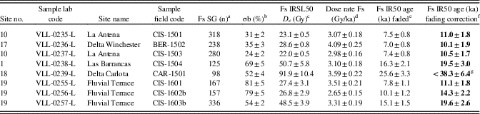
For equivalent dose determination, a single grain dating approach was applied, using the IR50 (infrared stimulated luminescence at 50°C) signal of single grains of potassium-rich feldspar, which is expected to be the most easily bleachable K-feldspar signal (Blomdin et al., Reference Blomdin, Murray, Thomsen, Buylaert, Sohbati, Jansson and Alexanderson2012). All measurements were conducted in the VLL using a Risø DA-20 automated luminescence reader system (Bøtter-Jensen et al., Reference Bøtter-Jensen, Bulur, Duller and Murray2000, Reference Bøtter-Jensen, Andersen, Duller and Murray2003). A Canberra gamma spectrometer with a high-purity Germanium detector (40% n-type) was used at the VLL for high-resolution, low-level gamma spectrometry, to determine the content of naturally occurring radionuclides (238U and 232Th decay chains, as well as 40K) contributing to the external dose rate. A description of the methodological luminescence dating approach and the experimental setup used in this study, as well as all detailed results from pretests, equivalent dose, and does rate determination are provided in the Supplementary Materials. Incomplete bleaching was detected for some samples under investigation (see Table 4). Because of that, different age models (central age model [CAM] and minimum age model [MAM], both Galbraith et al. [Reference Galbraith, Roberts, Laslett, Yoshida and Olley1999]) were applied for the calculation of the equivalent dose values for the samples. Details about the statistical data evaluation can be found in the Supplementary Materials.
Summary of optically stimulated luminescence data. See Figure 1 for site locations.

a Number of grains passing all rejection criteria. SG= single grain; Fs= Feldspar.
b Overdispersion calculated using the central age model (CAM; Galbraith et al., Reference Galbraith, Roberts, Laslett, Yoshida and Olley1999).
c Calculated using the CAM (Galbraith et al. Reference Galbraith, Roberts, Laslett, Yoshida and Olley1999) for samples CIS-1501, BER860-1502, and CIS-15-03. All other samples calculated using the minimum age model MAM-3 (Galbraith et al., Reference Galbraith, Roberts, Laslett, Yoshida and Olley1999) with a threshold value of 0.3 for σb. IRSL50= Infra-Red Stimulated Luminescence at 50°C.
d Overall dose rate. For details, see Supplementary Materials.
e Ages calculated using the software ADELE (Kulig, 2005). IR50, infrared stimulated luminescence at 50°C.
f Fs-based ages corrected for fading according to the method of Huntley and Lamothe (Reference Huntley and Lamothe2001) using the R Luminescence package (Kreutzer et al., Reference Kreutzer, Schmidt, Fuchs, Dietze and Fuchs2012). These ages are printed in bold characters, because they are used for all subsequent interpretations.
g This age must be interpreted as a maximum age.
RESULTS
In this section, we describe landforms and sediments deposited by Río Cisnes Glacier. We provide geochronological control, wherever this is available, from Río Cisnes as well as from nearby Río El Toqui and Río Ñirehuao basins.
Glacial and deglacial geomorphology
Moraines
Distinct moraine belts are widespread within the upper Río Cisnes valley (Fig. 2). Five moraines that tentatively could be associated to the last glacial period occur along an ~50 km east–west transect. We name them here as CIS I to CIS V, from eastward (older) to westward (younger) (Fig. 2). The two outer CIS I and CIS II moraine belts are interpreted to represent full glacial conditions, when Río Cisnes Glacier expanded up to, or beyond, the Chile-Argentina border during the local LGM. A minimum basal age obtained from Lake Shaman in an inner CIS II intermorainic depression yielded 19.0±0.2 cal ka BP, which implies ice deposited the CIS II moraine before this time, likely during the global LGM (26–19 ka; Mix et al., Reference Mix, Bard and Schneider2001; Clark et al., Reference Clark, Dyke, Shakun, Carlson, Clark, Wohlfarth, Mitrovica, Hostetler and McCabe2009; De Porras et al., Reference De Porras, Maldonado, Abarzúa, Cárdenas, Francois, Martel-Cea, Stern, Méndez and Reyes2012). The inner CIS III, CIS IV, and CIS V moraines represent readvances or still stands of reduced extents during deglaciations. CIS I and CIS II include multiple moraine ridges, partially reworked by meltwater erosion. Meltwater conduits and fluvioglacial plains paralleling the former ice snout can separate both moraine belts. The moraines resemble a hummocky landscape including adjacent, distinct wide-radii crests forming continuous ridges. Sporadic boulders top the moraines, and CIS I and CIS II moraine slopes can reach as much as ~20°. The CIS III moraine is preserved at the northern side of the Río Cisnes, ~16 km to the west (up-ice direction) of CIS II (Fig. 2). The moraine ridge exposes a symmetric cross section that can be 500 m wide and 35 m high. It is preserved as a semiarcuate loop with the northern lateral descending downhill and turning south to form the frontal part, proximal to the main road. The next inboard CIS IV moraine belt occurs 7 km downvalley and can be tracked mostly as a single arcuate crest almost continuously for about 10 km on both sides of the Río Cisnes (Fig. 3). The moraine shape is irregular along its main frontal axis; some sections are massive and follow a linear geometry (north of the Río Cisnes), and others can be undulating or zigzag (south of Río Cisnes). The moraine relief can be as high as ~200 m. The top of the moraine north of Río Cisnes reaches 745 m asl but climbs above 920 m asl to the south, where we sampled boulders for 10Be dating. Here, the proximal slope occurs close to the angle of the repose (~25°–30°). Lateral crests enclose small lakes that we cored and 14C dated (Lago Bernema). The next inboard CIS V moraine belt occurs 25 km to the west of CIS IV (Fig. 3). Three parts make up this moraine belt and expose three divergent lobes, separated by topographic relief. The main moraine at Río Cisnes valley forms a steep arc on both sides of the valley. We have mapped the moraines standing at the front of Lago Las Quemas and at the head of the Río Las Quemas to be part of the same CIS V moraine (Fig. 2). The Lago Junco Site (Weller et al., Reference Weller, de Porras, Maldonado, Méndez and Stern2017), whose basal 14C age we discuss subsequently, occurs between these two moraines at Las Quemas (Figs. 1, 2, and 3). In summary, five moraine belts are well preserved within the upper Río Cisnes valley. Whereas the outer CIS I and CIS II represent full glacial conditions, the inner CIS III, CIS IV, and CIS V landforms represent readvances of Río Cisnes Glacier that interrupted the overall glacial retreat at the end of the last glacial period.
Four 10Be ages from boulders resting on top of the deglacial CIS IV moraine ranged from 21.3±0.8 to 19.2±0.8 ka and yielded an arithmetic mean age for the culmination of the associated glacial advance that built this moraine of 20.1±1.2 ka. As discussed previously, boulders were sampled above any potential lake that could have existed, and therefore, no lake-related disturbance of the sample sites is expected to have affected the exposure ages.
Paleolake shorelines
The upper Río Cisnes valley includes paleolake shorelines and deltas that are superimposed onto the glacial geomorphology (Fig. 2). These landforms are geomorphic evidence of former paleolakes, which developed within the Río Cisnes valley during deglacial times. Two distinct shorelines at 950–920 m asl and 860–850 m asl occur widely (Fig. 2). The wave-carved platforms are obvious in the aerial photographs and satellite images. We found no distinct change in elevation within short distances on these shorelines, but they are sometimes slightly higher to the west, probably in response to differential longitudinal postglacial isostatic rebound. At the east end of the valley at 950–920 m asl, a wave-cut bench was eroded in the proximal side of the CIS II moraine. Just inboard, the 860–850 m asl shoreline parallels the higher one. Whereas a distinct lake outlet to the Atlantic Ocean at 920 m asl eroded through CIS II and CIS I frontal moraines, no linkable lake outlet exists for the 860–850 m asl shoreline. Both major paleolake shorelines can be traced discontinuously to the west (up-ice direction) for at least 35 km, all the way between the moraine CIS II and moraine CIS V. The westernmost site where both lake benches outcrop together is the proximal slope of the CIS IV moraine, just below our 10Be dating site. At some locations, the 950–920 m asl and the 860 m asl main shorelines grade to lake deltas where we have applied OSL dating.
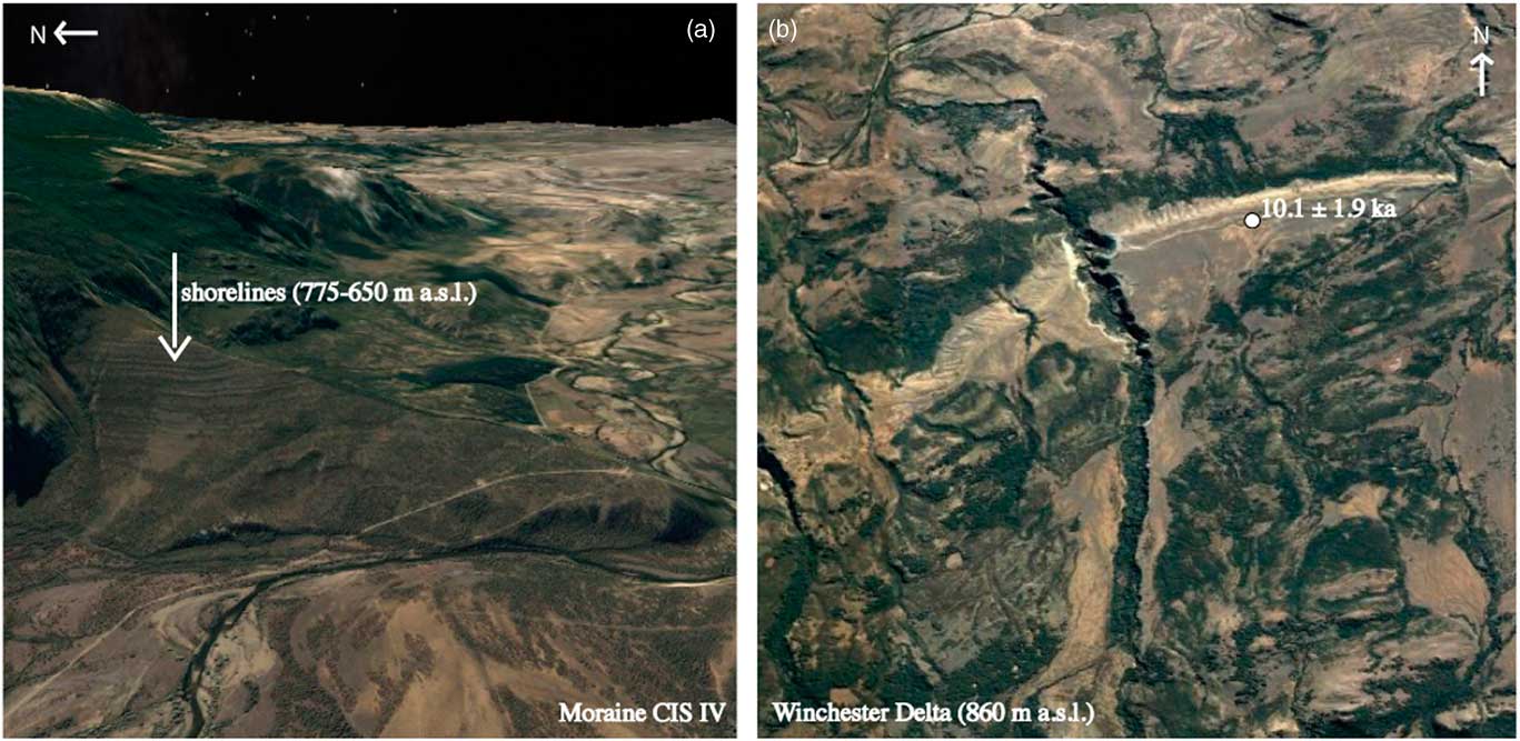
Less extensive shorelines ranging from 860 to 600 m asl are distinctive along the upper Río Cisnes valley. These occur as a sequence of multiple shorelines preserved on the Cisnes river side, on proximal sides of moraines and mountainsides. For instance, they are obvious on both sides of the Río Cisnes along the main road leading to the border (Fig. 2). Similarly, they are prominent on the proximal slopes of moraines CIS III and IV, north of the Río Cisnes (Fig. 4).
(color online) Geomorphic features at upper Río Cisnes. (a) Oblique view of the sequence of shorelines on the proximal side of the moraine Cisnes (CIS) IV. (b) Vertical view of the Winchester delta and superimposed beach berm at 860 meters above sea level (m asl). Optically stimulated luminescence sample location of site 17 and date of paleolake beach sediments are shown.

We have OSL dated sand making up perched delta landforms at two sites to constrain the age of the two main paleolake phases at Río Cisnes valley. The Carlota delta (950–920 m asl; Fig. 2) was fed by glacial meltwater until the glacier occupying the Lago Carlota retreated from its frontal moraines. Sample CAR-1501 obtained from glaciofluvial sandy gravel within this landform yielded an age of <38.3±6.4, which represents a maximum age for the lake at 950–920 m asl. An extensive alluvial fan ending at 860 m asl is well preserved on the south side of the valley (Winchester site; Fig. 4). On top of the alluvial surface, a lake beach berm occurs without distinct interruption for ~5 km. This landform can be 20–40 m wide and 1–2 m tall, and it is more obvious on the aerial photographs than in the field. Sample BER860-1502 (Fig. 4) taken from well-sorted coarse sand making up the 860–850 m asl beach yielded an age of 10.1±1.9 ka.
In the Ñirehuao valley, multiple shorelines occur between 740 and 600 m. A well-developed shoreline at 740 m can be traced to a perched lake spillway draining to the Atlantic. The Ñirehuao’s multiple shorelines <740 m cannot be traced to an outlet.
Fluvial terraces
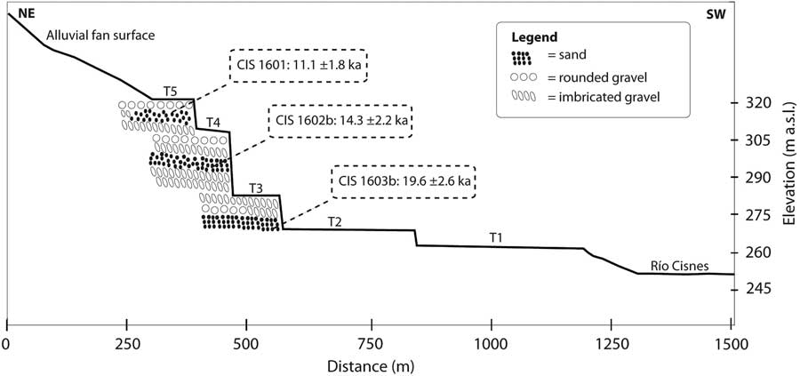
Multiple perched fluvial terraces occur along the middle Río Cisnes valley (Fig. 1). We mapped them and OSL dated their sediments to constrain the timing of postglacial landscape change. At the OSL sampling site, at least five distinct river terraces (TI–T5 from lower to upper; Figs. 1 and 5) were incised as high as ~70 m above present-day Río Cisnes. The highest terrace, T5, is an extensive former riverbed, well preserved in the middle Cisnes valley. Each terrace is separated from the next one by well-defined fluvial scarps, implying steady river incision. Sediment making up the terraces has distinct fluvial characteristics encompassing a range of granulometric sizes (Fig. 6). Coarse rounded to subrounded gravel may occur as openwork and matrix supported. Clasts expose a distinct westward fabric, indicating fluvial waters running toward the Pacific. Bedding can be rudimentary and reveal an inverse relation to grain size (i.e., coarse gravel is normally massive to faintly bedded). Well-laminated subhorizontal sand beds are frequent and appear intercalated with gravel at multiple sediment exposures. At the sampling site, we observe that river incision built the terraces in a prominent alluvial fan (Figs. 1, 5, and 6). A subsidiary glacier coming from the north is responsible for the accumulation of the glaciofluvial sediment making up this fan when the middle Río Cisnes valley was ice free. Therefore, older sediments occur at the base, and younger ones toward the top of the landform. The implication is that terraces at this site represent erosional features rather than depositional ones and indicate former levels of the Río Cisnes.
Deglacial sequence of Río Cisnes incision and terrace formation into a side-valley alluvial fan at middle Río Cisnes (site 19 in Fig. 1). Optically stimulated luminescence (OSL) ages obtained at the upper three terraces are shown (see Table 4 for further age details). m asl, meters above sea level. CIS= Cisnes.

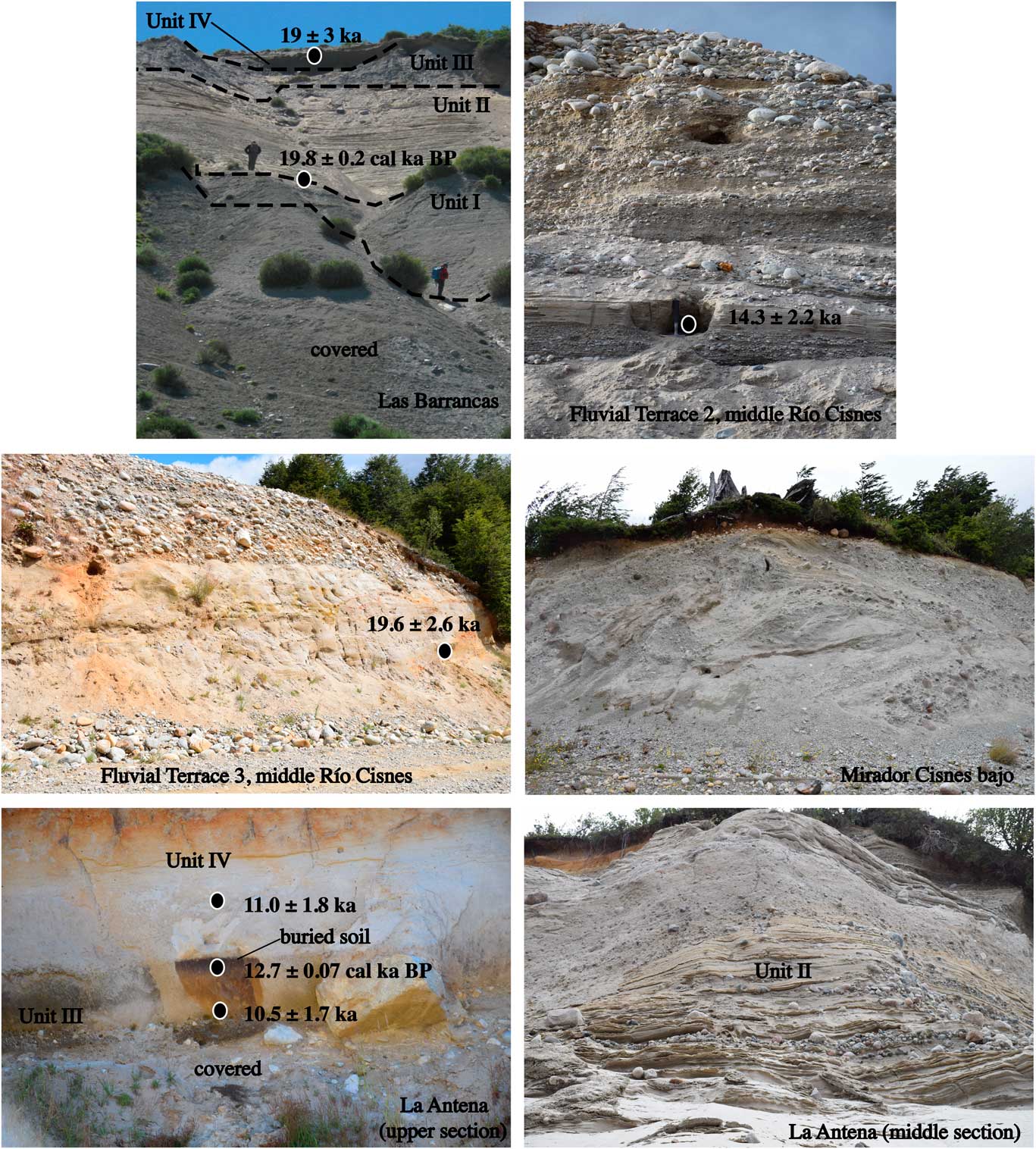
(color online) Stratigraphic sections studied and 14C and optically stimulated luminescence dated by this work (except for the lower calibrated 14C age in Las Barrancas, dated by Stern et al. [Reference Stern, de Porras and Maldonado2015]). Note the buried organic soil in La Antena section (lowest left photo) dated 12.7 cal ka BP. See text and Tables 1 and 4 for site and chronological details.

We targeted sand beds making up the upper T5, T4, and T3 terraces for OSL dating. We obtained the following correlative sequence of ages from lower to upper: sample CIS-1603b yielded an age of 19.6±2.6 ka (T3), sample CIS-1602b yielded an age of 14.3±2.2 ka (T4), and sample CIS1601 yielded an age of 11.1±1.8 ka. (Figs. 5 and 6, Table 4).
Stratigraphic sections
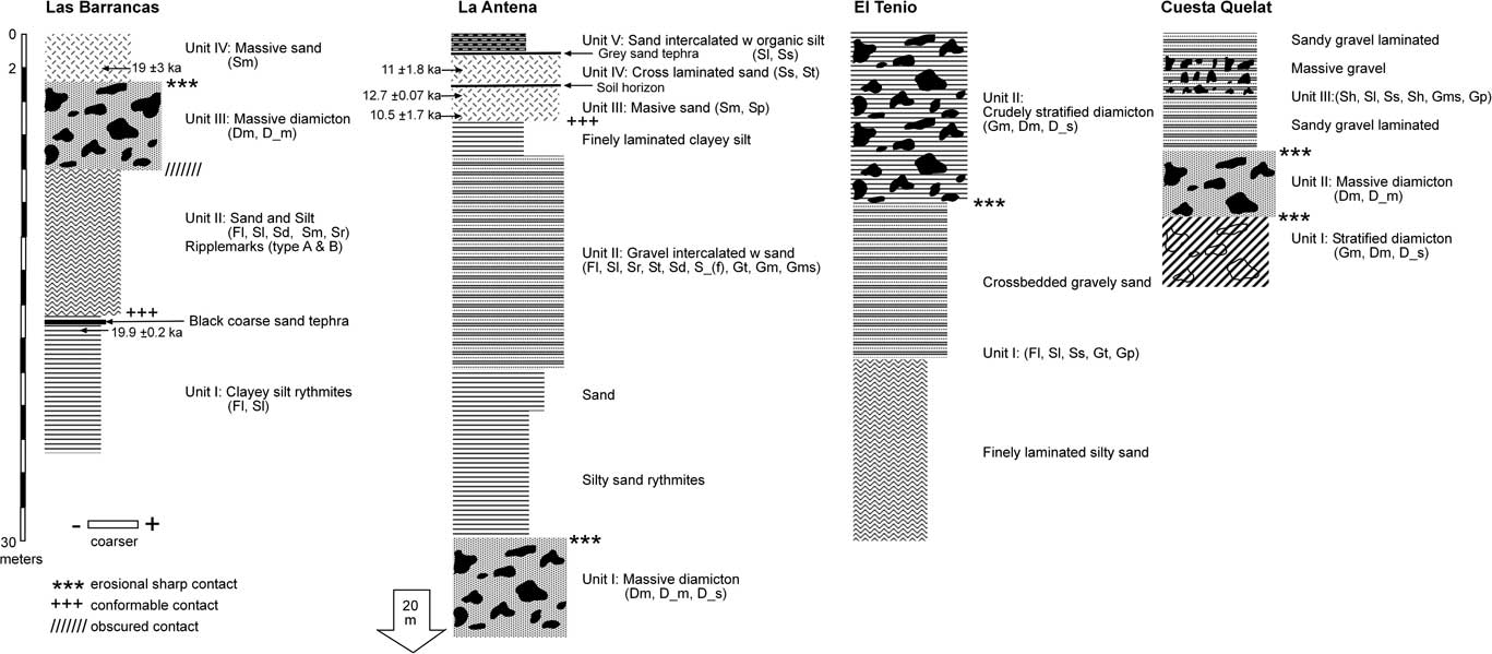
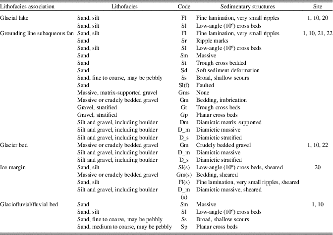
Multiple stratigraphic sections were analyzed in this study in order to obtain a more complete understanding of the glacial and deglacial phases in the Río Cisnes valley and surrounding areas. In this section, we describe the sediments making up the sites and provide chronological control wherever available. Stratigraphic columns with lithofacies descriptions are available in Figure 7. See Table 5 for lithofacies code details.
Stratigraphic columns and dating control at Río Cisnes. Lithofacies codes obtained and modified from Eyles et al. (Reference Eyles, Eyles and Miall1983). See Table 5 for code description. The lower date in Las Barrancas was reported in Stern et al. (Reference Stern, de Porras and Maldonado2015).

Sedimentary lithofacies attributes interpreted from stratigraphic sections (codes adapted from Eyles et al., Reference Eyles, Eyles and Miall1983).

Las Barrancas (upper Río Cisnes valley, 830 m asl; site 1)
This section occurs in the upper Río Cisnes valley, inboard from the CIS II moraine. It is a ~50 m exposure of sediments on the eastern riverside at 800–850 m asl (Figs. 2, 6, and 7). Four main units (I–IV) outcrop here. The basal unit I includes fine-grained sand and silt glaciolacustrine rythmites. These are well laminated and compacted. A 6-cm-thick, dark-colored tephra attributed to a pre-late-glacial eruption of the Melimoyu volcano (Stern et al., Reference Stern, de Porras and Maldonado2015) is intercalated within the unit. The contact with the upper unit II is obscured for the most part. Nonetheless, the sediment seems to grade conformably between units I and II, where a ripple cross-bedded sandy silt sediment is widespread. Sediment becomes coarser upward. Whereas silt predominates in the lower part, sand dominates higher in the section. Wavy and ripple structures are common, but massive sand intercalated with silt lamina is also present (Gustavson, Reference Gustavson1975; Johansen and Brennand, Reference Johnsen and Brennand2006). Silt infills the concave ripple segments (Ashley, 1975). Type A and B ripples (Jopling, Reference Jopling1967) occur asymmetrically and symmetrically intercalated with zones where there is an overall predominance of type B ripples with near vertical accumulation. Faulted and convoluted laminae can occur. Cut and fill structures are also present. The sediment of unit II is typical of that in subaqueous fans within glacial lake environments (e.g., García et al., Reference García, Strelin, Vega, Hall and Stern2015). The contact with the upper unit III is obscured. The latter can best be described as a diamictic sediment ~7 m thick. All sized clasts are present within an indurated sandy silt matrix. Some clasts are striated and subrounded (e.g., faceted) in shape. Based on these observations, we interpret unit III as a subglacial till (Boulton, Reference Boulton1987; Benn, Reference Benn1996), which implies a glacier sole deposit at the site. Massive sand of unit IV overlies the till with a sharp surface contact. Here, coarse sand grades to fine sand in the upper part of the section. The unit extends vertically for 1–2 m. The overall interpretation is that the Barrancas site records a glacial expansion over the area. This glacial expansion occurred over a glacial lake and reached an unknown extent.
An OSL sample (CIS-1504) obtained from the upper sand unit IV yielded an age of 19.5±3.0 ka. This provides a maximum age for the glacial advance recorded in the section and agrees with a bulk radiocarbon age of 19.8±0.2 ka reported by Stern et al. (Reference Stern, de Porras and Maldonado2015) from lower sediments (Table 3; Figs. 6 and 7).
La Antena (middle Río Cisnes valley, 550 m asl; site 10)
The site is located ~13 km inboard from CIS V moraine, where the Río Cisnes has carved a deep gorge into glacial sediments and underlying bedrock (Figs. 2 and 6). This is a thick stratigraphic section that it is possible to follow almost all the way down from the roadside to the river level, where local creek erosion has exposed more than 50 m of sediment (Fig. 7). Whereas the roadside section exposes a longitudinal view of the sediment body, the creek erosion exposes the cross section. Also, the exposure at the roadside has an upglacier orientation with respect to the creek exposure, both representing a sediment continuum. We were able to gain access close to the base of the section where a thick massive diamicton is well exposed (unit I). This thick basal unit, several tens of meters thick, includes subrounded to subangular clasts floating in an indurated fine sand matrix that altogether resembles a subglacial till (Boulton, Reference Boulton1987; Benn, Reference Benn1996; Glasser et al., Reference Glasser, Harrison, Ivy-Ochs, Duller and Kubik2006). The coarse stratification of the diamicton and its characteristics could also resemble hyperconcentrated flows at the glacier front in the sense of Evans et al. (Reference Evans, Rother, Hyatt and Shulmeister2013). The indurated sedimentary matrix supporting the clasts, together with the massive appearance of its upper part, leads us to favor the subglacial till interpretation for this sediment. This indicates a glacier advance that overrode the site and reached an unknown position to the east (down-ice direction). Unit I grades with a sharp erosional surface contact to glaciolacustrine stratified sand and gravel sediment that occupies most of the upper sediment section (unit II). A massive diamicton that was inaccessible for closer inspection appears bracketed by the stratified sediment. The sediment again resembles a massive subglacial till and could be exposing local fluctuations of a nearby ice front. Sand layers underlying this till appear faulted, presumably in response to the overlying loading. The stratified unit II is the most prominent in the section and exhibits well-developed eastward dipping (down-ice direction) layers. Sediment gets coarser toward the top. This trend can be locally disrupted by sharp grain-size changes, from silt to cobble range. Ripples that are made out of fine sand and silt are widespread in the lower part. Convoluted bedding and irregular bedding occur here. Outsized clasts occur and expose deformation of the upper and lower fine-grained layers, indicating dropstones (Benn, Reference Benn1996; García et al., Reference García, Strelin, Vega, Hall and Stern2015). Similarly, groups of stones are sprinkled within the sand sediment representing rain-out sediment deposited from icebergs (Benn and Evans, Reference Benn and Evans2010). Layers and lenses of crudely sorted gravel are intercalated with the sand strata, exposing the overall traction currents along the lake bottom. At the roadside, the sediment is coarser and exposes diamictic coarse gravel intercalated with finer sediment. Clasts here are subangular to subrounded and reach boulder size. The whole sediment package resembles a subaqueous fan environment, including the range of sediment sizes and structures that exists in these environments (e.g., Benn, Reference Benn1996; Evans et al., Reference Evans, Rother, Hyatt and Shulmeister2013; García et al., Reference García, Strelin, Vega, Hall and Stern2015). High-energy meltwater discharge in the form of cohesive to cohesion-less debris flow, plus bottom-lake currents and rain-out sediments from bergs are represented in the sediments (Evans et al., Reference Evans, Hiemstra and Cofaigh, C.2012, Reference Evans, Rother, Hyatt and Shulmeister2013). Very fine laminated glaciolacustrine rythmites can occur at the top of the subaqueous fan, which grades sharply into a massive gravelly fluvial sand and then pure coarse sand that has been pedogenized to form an organic horizon (Unit III), indicating postglacial subaerial conditions. The organic soil includes abundant charcoal macrofossils we have 14C dated to be 12.7±0.07 cal ka BP (sample CIS-1505). We have OSL dated sand underlying the buried soil to be 10.5±1.7 ka (sample CIS-1503), within 2 standard deviations of the 14C age. Overlying this buried soil, cross-bedded fluvial sorted sands occur (Unit IV) that we have OSL dated to 11.0±1.8 ka. A tephra layer interrupts Unit IV and gives way to fluvial sandy sediment that is intercalated with very finely laminated organic clayey-silt (Unit V). In summary, the sediments of the La Antena stratigraphic section expose Río Cisnes Glacier advancing over the site and then retreating to form a proximal glacial lake. Complete ice retreat and paleolake drainage followed and resulted in a fluvial environment that was interrupted by soil development at 12.7±0.07 cal ka BP.
Mirador Cisnes Bajo (lower Río Cisnes valley, 310 m asl; site 20)
This section occurs at the side of the Carretera Austral at a scenic viewpoint, a few km north of the Villa Amengual (Fig. 1). The section is 5 m high and we interpret it to represents a stepped ice retreat of Río Cisnes Glacier during deglaciation (Fig. 6). The sediment includes deformed and thrusted packages of layered sandy gravel, massive diamictic gravel and glaciolacustrine sediments, similar to other ice-marginal Patagonian environments (e.g., Denton et al., Reference Denton, Lowell, Heusser, Schlüchter, Andersen, Heusser, Moreno and Marchant1999; Glasser et al., Reference Glasser, Harrison, Ivy-Ochs, Duller and Kubik2006). Matrix-supported gravel up to boulder size occupies most of the section, except for the upper part where well-sorted fine sediment of glaciolacustrine origin occurs. Diamictic gravels are possible to follow, but only for short distances because they have been mixed with surrounding finer glaciolacustrine rip-up sediment (cf. Glasser et al., Reference Glasser, Harrison, Ivy-Ochs, Duller and Kubik2006). The sediment indicates a high-energy environment close to, or at, a fluctuating ice snout, where rivers exit from the ice (Evans et al., Reference Evans, Rother, Hyatt and Shulmeister2013; García et al., Reference García, Strelin, Vega, Hall and Stern2015). Therefore, the sediment denotes ice-contact diamictic mass-flow deposits. Pervasive deformation implies ice pushing the sediment and locally overriding it (Evans et al., Reference Evans, Rother, Hyatt and Shulmeister2013; García et al., Reference García, Strelin, Vega, Hall and Stern2015). Upper well-laminated sediments were deposited in a proglacial lake as the ice retreated westward away from the site. The general overview is that most of this sediment was deposited at Glacier Cisnes frontal margin that experienced local fluctuations as it retreated and disintegrated in its way toward the mountain highlands.
El Tenio (lower Río Cisnes valley, 170 m asl, site 21)
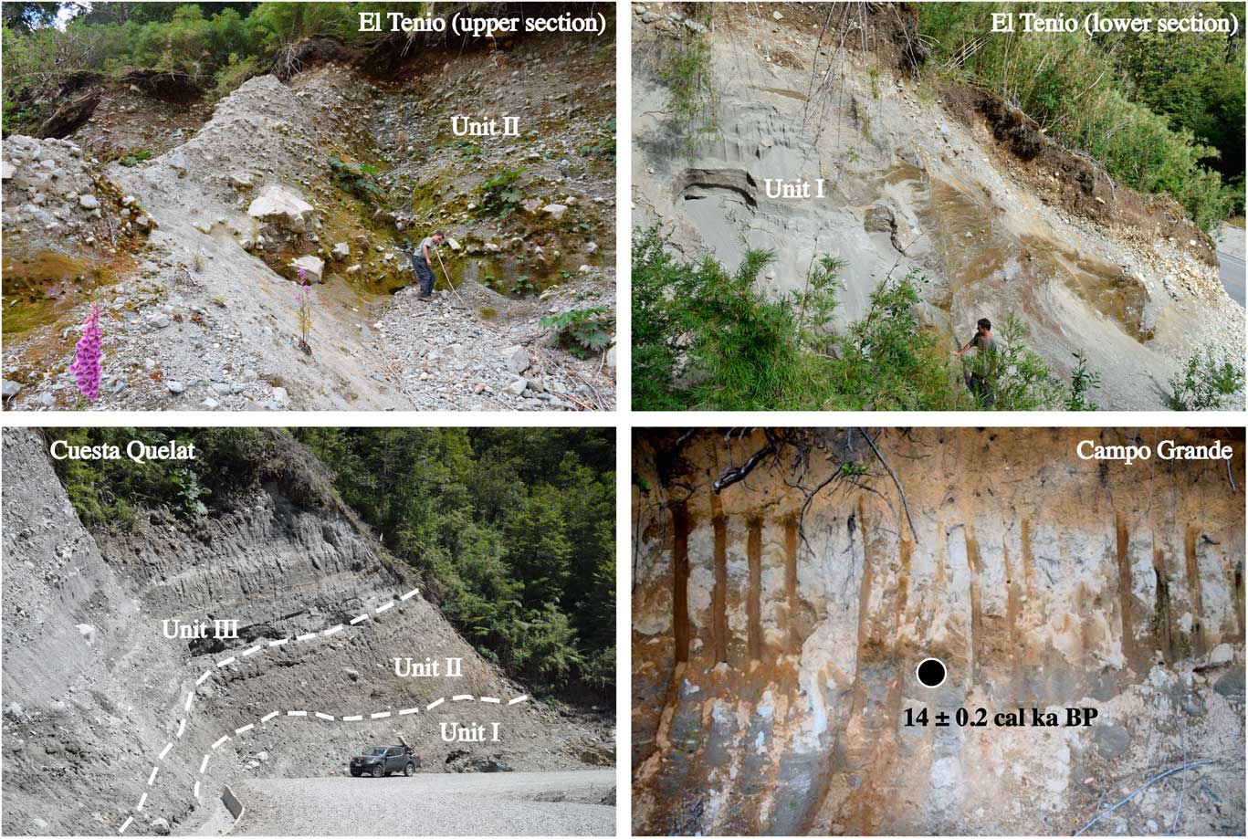
This section is also located along the Carretera Austral road. It can reach up to 30 m in height. Two main sediment units make up this stratigraphic section, which is located in an up-ice direction from the Mirador Cisnes Bajo section and Laguna Las Mellizas (Fig. 1). The basal Unit I is composed first of rhythmically laminated fine-grained sand and silt that coarsens upward into gravelly sand (Fig. 8). The sediment exposes a subparallel sinusoidal lamination up to 20 m thick (Gustavson, Reference Gustavson1975). Toward the top of the unit the gravelly sand can be cross-bedded. The sediment structure indicates an eastward direction of flow (down-ice direction). The top unit is a ~10 m massive to coarsely stratified gravelly diamicton deposited with an erosional surface on Unit I. The diamicton includes subrounded to subangular and angular clasts within a coarse sand matrix. All grain sizes are present, including meter sized angular boulders. A distinct layer of big boulders (e.g., pavement) is present. Units I and II can be interpreted to represent distal and proximal segments of a grounding-line fan, respectively (Benn and Evans, Reference Benn and Evans2010). The overall implication is a glacial readvance by Río Cisnes Glacier that reached a position at or nearby the site within a glacial lake environment. This interpretation is based on the upward coarsening of the sediment within the section from Unit I to Unit II, which we interpret as an approaching ice. In this regard, the well laminated sandy sediment (Unit I) can be regarded as distal debris flow and underflow activity (e.g., Benn, Reference Benn1996; García et al., Reference García, Strelin, Vega, Hall and Stern2015), whereas the upper diamictic sediment resembles rather hyperconcentrated flows deposited at the apex of the subaqueous fan where high energy subglacial currents enter the glacial lake (Evans et al., Reference Evans, Rother, Hyatt and Shulmeister2013).
(color online) Stratigraphic sections studied by this work. The El Tenio section (upper two photos) illustrates coarsening upward from glaciolacustrine rythmites to debris flow sediments. The 14C age at Campo Grande glaciolacustrine sediment indicates the late-glacial age of these sediments.

Cuesta Queulat (lower Río Cisnes valley, 305 m asl, site 22)
A prominent glacial sediment section is well exposed on the roadside of the Carretera Austral south of the Queulat pass (Fig. 1). This is located at ~305 m asl, a few kilometers north of Río Cisnes bed and west from the El Tenio site, at the Andean mountain core. This is the westernmost site discussed here. The section is located along a tributary valley where a former glacier flowed south into the Río Cisnes valley. The site includes hundreds of meters of sediment exposures that show three main sediment units, all dipping downvalley (Fig. 8). The underlying units I and II are diamictic sediments that include subrounded to subangular clasts floating in an indurated sandy silt matrix. Whereas unit I includes a dipping cross-stratified sediment, unit II is massive. Pockets of poorly sorted clasts may occur in unit II. Grain size includes the silt-boulder range, and both units include outsized clasts. The surface contact between both units is unconformable and includes a thin stratum of fine laminated compacted sediment. Based on these observations, we suggest that the basal unit I represents unchannelized cohesive debris flow sediment (Benn, Reference Benn1996; Benn and Evans, Reference Benn and Evans2010; Evans et al., Reference Evans, Rother, Hyatt and Shulmeister2013). The upper unit II can be interpreted as a subglacial till. As in La Antena site, the indurated massive fine matrix supporting the clasts of unit II can be used to interpret the sediment as a till deposited at the glacier base (Boulton, Reference Boulton1987). The surface contact between unit II and upper unit III is sharp. Unit III occupies most of the section. Thick coarse gravel intercalated with laminated sandy gravel that grades to fine laminated sandy silt glaciolacustrine sediment along the outcrop provides the overall stratified aspect of the sediment deposited within an ice-contact subaqueous fan (Benn, Reference Benn1996; Evans et al., Reference Evans, Hiemstra and Cofaigh, C.2012; García et al., Reference García, Strelin, Vega, Hall and Stern2015). Traction current sand linked to underflow deposits is widespread within a sequence of abrupt vertical changes in the grain size (Benn, Reference Benn1996). Outsized clasts are present, and a rudimentary fabric can occur downhill (toward the Río Cisnes), indicating aggrading gravity-fed mass flow sediments that originated near or at the ice front (Evans et al., Reference Evans, Rother, Hyatt and Shulmeister2013). The sediment grain size decreases downhill from coarse gravel to fine well-laminated glaciolacustrine rythmites showing the proximal to distal sequence that is common in subaqueous glacier-fed outwash fans (Benn, Reference Benn1996; Ben and Evans, Reference Benn and Evans2010; García et al., Reference García, Strelin, Vega, Hall and Stern2015). Among others, the Cuesta Queulat sediment section implies an ice advance from the north to the site, after which the site was occupied by an ice-proximal lake that attained an elevation >300 m asl. The existence of this lake is presumably conditioned by the presence of damming ice in the Río Cisnes valley during the tardiest part of the deglaciation. Therefore, this should be regarded as one of the last glacial pulses before complete deglaciation.
Campo Grande (Río El Toqui valley, ~280 m asl, site 6)
This is a sediment section outcropping on a hillside that encloses a peat bog. It is located in the Campo Grande farm, at the lower Río El Toqui valley (Fig. 1). The section exposes well-laminated glaciolacustrine rythmites that grade upward in color from gray to pale brown. The top of the outcrop exposes a thick, light-orange tephra, with centimeter-size pumice clasts. Several charcoal fragments occur embedded in the glaciolacustrine sediment. We 14C dated one of the fragments, obtaining an age of 14±0.2 cal ka BP that helps to constrain the deglacial paleolake history in the region (Fig. 8).
Basal 14C ages
We obtained three 14C basal ages that reveal local timing for ice-free conditions in the Río Cisnes, Río Toqui, and Río Ñirehuao former glacial basins: Lago Bernema (site 5), Mallín El Toqui (site 8), and Laguna La Trapananda (site 3), respectively (Fig. 1, Table 1). Lago Bernema (930 m asl; Fig. 3) is a small rounded basin enclosed by CIS IV moraines in the upper Río Cisnes valley. The contact between glacial lake and organic sediments yielded an age of 16.2±0.2 cal ka BP and represents a minimum age for Río Cisnes Glacier retreat from the CIS IV moraine position and a former paleolake drainage below ~930 m asl. The Mallín El Toqui (705 m asl; Fig. 3) is located ~35 km south of Cisnes valley, at Río El Toqui valley. This mire occurs on the northern valley side, on a glacially molded bedrock closed basin. We obtained an age of 12.8±0.1 cal ka BP for the basal contact with glaciolacustrine sediments, which represent a minimum age for local ice-free conditions and glacial lake drainage below 700 m asl. Laguna La Trapananda (1160 m asl; Fig. 3) is located at the southern part of the Río Ñirehuao basin, 75 km south of Río Cisnes valley. It occurs behind multiple frontal moraine crests deposited by the former Río Ñirehuao Glacier on top of glacially scoured hillside relief at the present-day treeline. The basal age of this core yielded 18.5±0.2 cal ka BP, which represents a minimum age for the ice retreat and local ice-free conditions.
We also obtained a core at Lago Junco (700 m asl; Figs. 2 and 3) in upper Río Cisnes and at Laguna Las Mellizas (205 m asl; Fig. 1). Lago Junco is located at the bottom of a small enclosed rocky basin on a northern valley shoulder, between CIS V moraines. The contact between the glacial inorganic clays and the organic sediment (gyttja) yielded an age of 16.9±0.3 cal ka BP, as reported by Weller et al. (Reference Weller, de Porras, Maldonado, Méndez and Stern2017), which is a minimum age for local ice-free conditions and paleolake drainage below 700 m asl. Laguna Las Mellizas, located 40 km downriver from the Lago Junco, is a double-lake system occurring within a small closed basin near the valley bottom. The contact between glacial sediments and organic mud (gyttja) has been dated to 12.3±0.2 cal ka BP, as reported in Weller et al. (Reference Weller, de Porras, Maldonado, Méndez and Stern2017), and denotes a minimum age for local ice-free conditions and glacial paleolake drainage below 200 m asl.
DISCUSSION
Interpretation of OSL ages
By applying the chosen single-grain feldspar SAR3 approach for determination of the equivalent dose, it was possible to reliably identify incompletely bleached samples in the data set. The resulting ages were subsequently corrected for fading following the approach of Huntley and Lamothe (Reference Huntley and Lamothe2001) and show consistent results with respect to their relative stratigraphic position. At two sites, age control is available from independent methods. At the Antena site, samples CIS-1501 (11.0±1.8 ka) and CIS-1503 (10.5±1.7 ka) are in good agreement of each other within error and bracket a radiocarbon date providing a maximum deposition age of 12.7±0.07 cal ka BP, in excellent agreement with both of the above OSL ages. At Las Barrancas site, sample CIS-1504 (19.5±3.0 ka), agrees with the maximum calibrated 14C age of organic sediments deposited at 19.8±0.2 cal ka BP (Stern et al., Reference Stern, de Porras and Maldonado2015). Incomplete bleaching was detected for sample CAR-1501, which in addition also shows a very limited data set. This prevents a thorough statistical analysis using the MAM-3 of Galbraith et al. (Reference Galbraith, Roberts, Laslett, Yoshida and Olley1999), and we therefore interpret this age as a maximum age; in other words, deposition happened <38.3±6.4 ka (see the Supplementary Materials). Therefore, the age of this sample only provides a maximum age estimate for a glacial paleolake level at 920–950 m asl in the Cisnes basin. Sample BER860-1502 yielded an age of 10.1±1.9 ka for the beach berm deposits. From a methodological point of view, this age is based on a solid data set and can be regarded as reliable. However, considering the evidence from 14C dating presented previously, the age for sample BER860-1502 is not representative for a glacial paleolake at 860 m asl occurring at this time at Cisnes basin. At the sampling site, a layer of fine sandy sediments covers the gravelly sandy sediments of the beach berm. Potential relocation and downward migration of the stratigraphically younger cover sediments into the pores of the coarser beach berm deposits may explain the age underestimation of the luminescence age for the beach berm sediments. The three samples taken from the glaciofluvial fan structure originating from a northern side valley of the Río Cisnes are in stratigraphic order and document glaciofluvial deposition from 19.6±2.6 ka to 11.1±1.8 ka.
Glacial advances
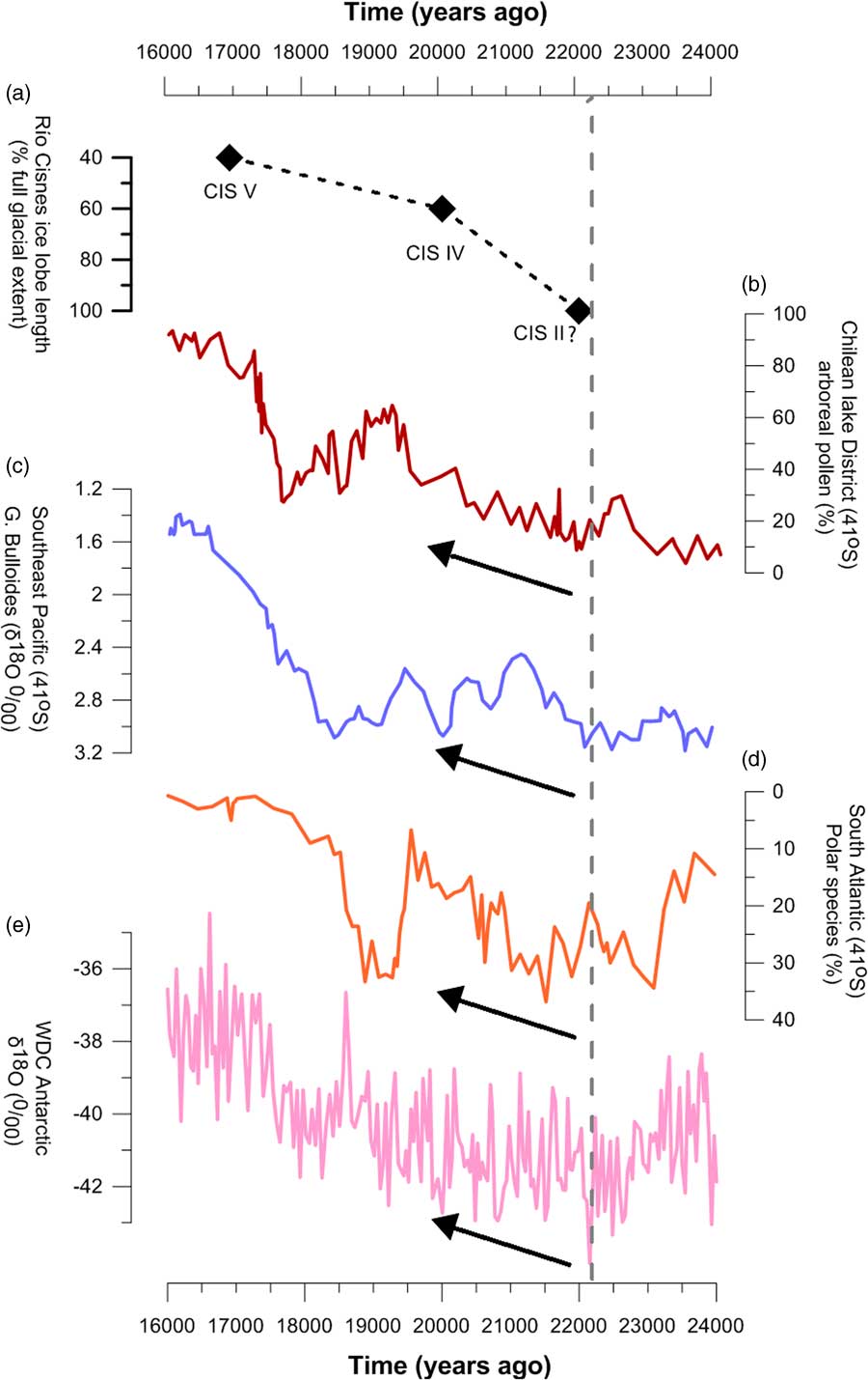
Our mapping of landforms and stratigraphic sections indicate multiple advances, readvances, or still stands by Río Cisnes Glacier. With the available chronological data we can only provide partial dating for all glacial advances interpreted by this study. The glacial advance that built CIS IV moraine culminated at 20.1±1.2 ka. CIS II moraine was deposited earlier than 19 ka (De Porras et al., Reference De Porras, Maldonado, Abarzúa, Cárdenas, Francois, Martel-Cea, Stern, Méndez and Reyes2012). Because the Lago Junco could only have accumulated organics after ice retreated from moraine V (so ice had stopped feeding the site with meltwater), the age of the associated glacial advance should precede 16.9±0.3 cal ka BP. Therefore, the CIS V moraine building culminated after 20.1±1.2 ka and before 16.9±0.3 cal ka BP. This glacial readvance could have coincided with that recorded at the Las Barrancas site. Taking the data at face value, the till in Las Barrancas site was deposited after 19.8±0.2 ka (Stern et al., Reference Stern, de Porras and Maldonado2015) and before 19.5±3.0 ka (this study), which brackets this glacial readvance to between ~20 and 16 ka. Therefore, it seems likely that Las Barrancas represents a glacial expansion from the southeast mountain catchments when local ice had become isolated from the main Río Cisnes Glacier. The ice marginal position recorded at La Antena site occurred before 12.7±0.07 cal ka BP. With the available chronological data, we can only constrain this ice stabilization to between 16.9±0.3 and 12.7±0.07 cal ka BP. The other stratigraphic records identifying glacial readvances or stabilizations to the west, such as El Mirador Cisnes Bajo, El Tenio, and Cuesta Queulat occurred later in the deglaciation but likely before 12.3±0.2 cal ka BP, as revealed at Laguna Las Mellizas at the core of the Patagonian Andes. A late-glacial stabilization or readvance of the Río Cisnes during the Antarctic Cold Reversal (ACR) is not evident from our data, but this cannot be ruled out. In fact, as discussed subsequently, paleolake evidence would suggest such a scenario for the Río Cisnes and nearby glaciers. In summary, several glacial readvances or at least front stabilizations occurred between ~20 and 12 ka; two of these culminated at 20.1±1.2 ka (CIS IV) and 20.1±1.2 to 16.9±0.3 ka (CIS V).
Deglaciation
In order to address the timing and rate of the northern PIS retreat at the end of the last glaciation, we now analyze the geomorphic and stratigraphic record and the available geochronological control at the Río Cisnes valley. We contrast our observations with other nearby Patagonian glacier records so as to provide a wider view of the regional deglacial history. We first describe the early deglaciation period and then the late-glacial period.
De Porras et al. (Reference De Porras, Maldonado, Abarzúa, Cárdenas, Francois, Martel-Cea, Stern, Méndez and Reyes2012) obtained a basal age of 19±0.2 cal ka BP at Lago Shaman within the inner CIS II moraine belt, implying that Río Cisnes Glacier retreated before 19 ka from its local LGM by this time. This age is statistically indistinguishable from the OSL age at the Las Barrancas site (19.5±3.0 ka; Figs. 6 and 7), dating local ice-free conditions. The age is also indistinguishable from the age of the inner CIS IV moraine at 20.1±1.2 ka. If one considers the highest topographic axis of the Andes as the former PIS ice divide, which may not be the case, the CIS IV moraine age implies that ice retreated ~35 km (40% of ice loss) between CIS II and CIS IV moraines by 20.1±1.2 ka. Between 20.1±1.2 ka and 16.9±0.3 cal ka BP, Río Cisnes Glacier front retreated another ~25 km between the CIS IV and CIS V moraines, resulting in a further 20% loss of ice extent by this time. Together with the available 14C and 10Be data in Río Cisnes basin, the OSL record suggests that Río Cisnes Glacier had retreated through the middle Río Cisnes valley by 17 ka, implying that after ice deposited the CIS V moraine, extensive ice front retreat continued to occur.
There is substantial evidence that ice retreat was underway by ~19 ka, not only in Cisnes but also in other Patagonian sites (Markgraf et al., Reference Markgraf, Whitlock and Haberle2007; Murray et al., Reference Murray, Carlson, Singer, Anslow, He, Caffee, Marcott, Liu and Otto-Bliesner2012; Henríquez et al., Reference Henríquez, Villa-Martínez, Vilanova, De Pol-Holz and Moreno2017; Mendelova et al., Reference Mendelova, Hein, McCulloch and Davies2017). The 19±0.2 cal ka BP minimum age at Lago Shaman agrees with the basal minimum age of 18.5±0.2 cal ka BP of Laguna La Trapananda (Río Ñirehuao Glacier, 45°S) recorded by this study and the basal minimum age of 18.6±0.2 cal ka BP of Mallín Pollux (45°S) (Markgraf et al., Reference Markgraf, Whitlock and Haberle2007). Lago Cochrane Glacier (also referred to in the literature as the Lago Pueyrredón Glacier) (47°S) recorded a similar deglacial trend (Hein et al., Reference Hein, Hulton, Dunai, Kaplan, Sugden and Xu2010; Villa-Martínez et al., Reference Villa-Martínez, Moreno and Valenzuela2012; Boex et al., Reference Boex, Fogwill, Harrison, Glasser, Hein, Schnabel and Xu2013; Henríquez et al., Reference Henríquez, Villa-Martínez, Vilanova, De Pol-Holz and Moreno2017; Mendelova et al., Reference Mendelova, Hein, McCulloch and Davies2017). Based on minimum basal 14C ages obtained in the Chacabuco valley, Henríquez et al. (Reference Henríquez, Villa-Martínez, Vilanova, De Pol-Holz and Moreno2017) suggested that by 19.5 ka Lago Cochrane Glacier had retreated at least ~90 km from the (inner) LGM Río Blanco moraine deposited at ~21 ka (Hein et al., Reference Hein, Hulton, Dunai, Kaplan, Sugden and Xu2010). Because former ice flow lines have not been mapped in detail in the Chacabuco valley yet, it cannot be ruled that the 19.5 ka reported in this study could represent ice thinning rather than ice front retreat. In any case, the age does provide evidence for local ice-free conditions and therefore that the LGM ice demise was in progress by 19.5 ka in this valley (Mendelova et al., Reference Mendelova, Hein, McCulloch and Davies2017). Another piece of evidence comes from glaciers in the Río Guanaco valley (50°S) in the eastern southernmost Andes, which also began significant retreat by 19 ka (Murray et al., Reference Murray, Carlson, Singer, Anslow, He, Caffee, Marcott, Liu and Otto-Bliesner2012).
Ice-free conditions in the middle Río Cisnes by 17 ka, representing >60% of ice loss, is mirrored by the extensive deglaciations of numerous Patagonian glaciers by this time. Lago Cochrane Glacier had thinned >1000 m by 16.8 ka exposing previously glaciated mountain relief (Boex et al., Reference Boex, Fogwill, Harrison, Glasser, Hein, Schnabel and Xu2013). Similarly, Lago General Carrera Glacier (46°S) retreated at least 65–100 km between about 17.5 and 16.3 ka (Kaplan et al., Reference Kaplan, Ackert, Singer, Douglass and Kurz2004, Reference Kaplan, Strelin, Schaefer, Denton, Finkel, Schwartz, Putnam, Vandergoes, Goehring and Travis2011; Turner et al., Reference Turner, Fogwill, McCulloch and Sugden2005; Mendelova et al., Reference Mendelova, Hein, McCulloch and Davies2017). The Río Guanaco valley glaciers had lost about half of their estimated full glacial extent by 17±0.3 ka (Murray et al., Reference Murray, Carlson, Singer, Anslow, He, Caffee, Marcott, Liu and Otto-Bliesner2012). To the south, Lago Argentino Glacier (50°S) had retreated into the Andes by 16.2±0.2 ka (Strelin et al., Reference Strelin, Denton, Vandergoes, Ninnemann and Putnam2011). Similar extensive ice retreat into the Cordillera Darwin Ice Field (54°S) at least by 16.5±0.2 ka was recorded upglacier from the Strait of Magellan (Hall et al., Reference Hall, Porter, Denton, Lowell and Bromley2013, Reference Hall., Denton, Lowell, Bromley and Putnam2017). The same trend has been recorded in the Chilean Lake District and Chiloé (39–42°S) to the north, where glaciers had collapsed back to the Andes Mountains by ~16.8 ka, after extensive retreat during the previous 1000 yr (Moreno et al., Reference Moreno, Denton, Moreno, Lowell, Putnam and Kaplan2015).
Despite the extensive glacier loss that characterized the PIS demise in Patagonia, ice still stands and moraine building interrupted the overall deglacial trend. There is a stepwise retreat of Patagonian glaciers between >19 and 17 ka. At Río Cisnes valley, the inboard CIS III, CIS IV, and CIS V moraines occupy a similar morphostratigraphic position as the Lago Columna and María Elena moraines deposited by Lago Cochrane Glacier inboard from the local LGM limits in the Chacabuco/Lago Cochrane basins (47°S; Hein et al., Reference Hein, Hulton, Dunai, Kaplan, Sugden and Xu2010; Boex et al., Reference Boex, Fogwill, Harrison, Glasser, Hein, Schnabel and Xu2013). All these landforms were deposited when the Lago Cochrane had retreated to ~65–35% of its local LGM ice extent. For instance, Boex et al. (Reference Boex, Fogwill, Harrison, Glasser, Hein, Schnabel and Xu2013), based on a single 10Be age, dated the Lago Columna moraine at 20.0±2.4 ka, identical to the age of the CIS IV moraine at Río Cisnes. Similarly, Boex et al. (Reference Boex, Fogwill, Harrison, Glasser, Hein, Schnabel and Xu2013) 10Be dated the inboard María Elena moraine at 17.0±1.0 ka (n = 3), compatible with the age of the CIS V moraine at Cisnes between 20.1±1.2 and 16.9±0.3 ka and the readvance recorded at the Las Barrancas site (this study) between 20 and 16 ka.
The glacial record at Cisnes and other former Patagonian glaciers shows that there was significant glacial retreat during the latter part of the global LGM chronozone. This glacial dynamic can be interpreted by invoking at least two different scenarios. First, CIS II, CIS III, CIS IV, and CIS V moraines represent the local LGM in Cisnes, where the maximum extent predated 19 ka (e.g., CIS II moraine). In this scenario, the ice attained successive inboard positions through the LGM in Cisnes. Only after 17 ka (the CIS V moraine minimum age) did the ice rapidly retreat westward and deglaciation started proper. CIS II–CIS V moraines thus represent full glacial conditions attained during the local LGM. In the second scenario, only CIS II moraine (and CIS I moraine?) would represent the local LGM at Cisnes, and the inner CIS III–CIS V moraines would instead indicate ice still stands or readvances that interrupted ongoing local deglaciation. This scenario requires that deglaciation was underway before 19 ka if one considers at face value the 10Be exposure age of the inner CIS III moraine deposited at 20.1±1.2 ka and the Lago Shaman record (De Porras et al., Reference De Porras, Maldonado, Quintana, Martel-Cea, Reyes and Méndez2014). That is, under this scenario deglaciation started during the late global LGM chronozone. We prefer this latter scenario because Cisnes had lost near 40% of areal extent by 20.1±1.2 ka. We find it difficult to interpret this scale of glacial shrinkage as just ice retreat from a local LGM position. This retreat involved major loss of ice as the start of local deglaciation. There are two independent sources of evidence that support this conclusion. First, frequently Patagonian sites display well-nested global LGM chronozone moraines with 100–80% of full LGM ice extent. This implies that glaciers reached a similar advanced ice extent throughout the global LGM, rather than a large distance between LGM ice positions. In Río Cisnes valley the CIS II to CIS V moraines represent the change from 100% to 40% of LGM ice extent. Patagonian sites, such as Lago Buenos Aires, Bahía Inútil, and the Chilean Lake District, are good examples of well-mapped and spatially constrained LGM margins (Denton et al., Reference Denton, Lowell, Heusser, Schlüchter, Andersen, Heusser, Moreno and Marchant1999; Kaplan et al., Reference Kaplan, Ackert, Singer, Douglass and Kurz2004, Reference Kaplan, Fogwill, Sugden, Hulton, Kubik and Freeman2008; Bentley et al., 2005; McCulloch et al., Reference McCulloch, Fogwill, Sugden, Bentley and Kubik2005; Douglass et al., Reference Douglass, Singer, Kaplan, Mickelson and Caffee2006). Second, deglaciation usually connotes an extensive retreat from which the glacier never recovered again (Denton et al., Reference Denton, Anderson, Toggweiler, Edwards, Schaefer and Putnam2010; Bendle et al., Reference Bendle, Palmer, Thorndycraft and Matthews2017; Hall et al., Reference Hall., Denton, Lowell, Bromley and Putnam2017; Mendelova et al., Reference Mendelova, Hein, McCulloch and Davies2017), which is the situation we observe in Cisnes. Here, the ice attained only about 60% of its maximum extent by 20.1±1.2 ka and continued to retreat thereafter. In this regard, the main implications of the second scenario are that at Río Cisnes (1) deglaciation was underway by 19 ka or earlier, (2) ice had lost ~40% of its LGM extent by this time or earlier, (3) deglaciation was rapid but punctuated by several ice still stands or readvances, and (4) extensive deglaciation occurred about 1000 yr earlier than other Patagonian glaciers, which occurred at ca. 17.8 ka (e.g., Denton et al., Reference Denton, Lowell, Heusser, Schlüchter, Andersen, Heusser, Moreno and Marchant1999; McCulloch et al., Reference McCulloch, Bentley, Purves, Hulton, Sugden and Clapperton2000; Moreno et al., Reference Moreno, Denton, Moreno, Lowell, Putnam and Kaplan2015; Hall et al., Reference Hall., Denton, Lowell, Bromley and Putnam2017).
In summary, available evidence suggests that the Río Cisnes together with other Patagonian glaciers (e.g., Río Ñirehuao Glacier, Lago Cochrane Glacier, and Guanaco Glacier; Murray et al., Reference Murray, Carlson, Singer, Anslow, He, Caffee, Marcott, Liu and Otto-Bliesner2012; Henríquez et al., Reference Henríquez, Villa-Martínez, Vilanova, De Pol-Holz and Moreno2017; Mendelova et al., Reference Mendelova, Hein, McCulloch and Davies2017), started their deglaciation from their local LGM positions before 19 ka, earlier than the traditionally assumed start of regional deglaciation at ca. 17.8 ka. Although interrupted by glacial readvances or stabilizations that ended with prominent moraine deposition, ice retreat continued thereafter, and by 16.8 ka the Río Cisnes and other Patagonian glaciers had lost ~60% of their local LGM extent. A final deglaciation stage of Río Cisnes Glaciers into the Andean highlands occurred by 12.3±0.2 cal ka BP, as evidenced from concurrent ice-free conditions at Laguna Las Mellizas, near the core of the Andes.
Deglacial paleolakes
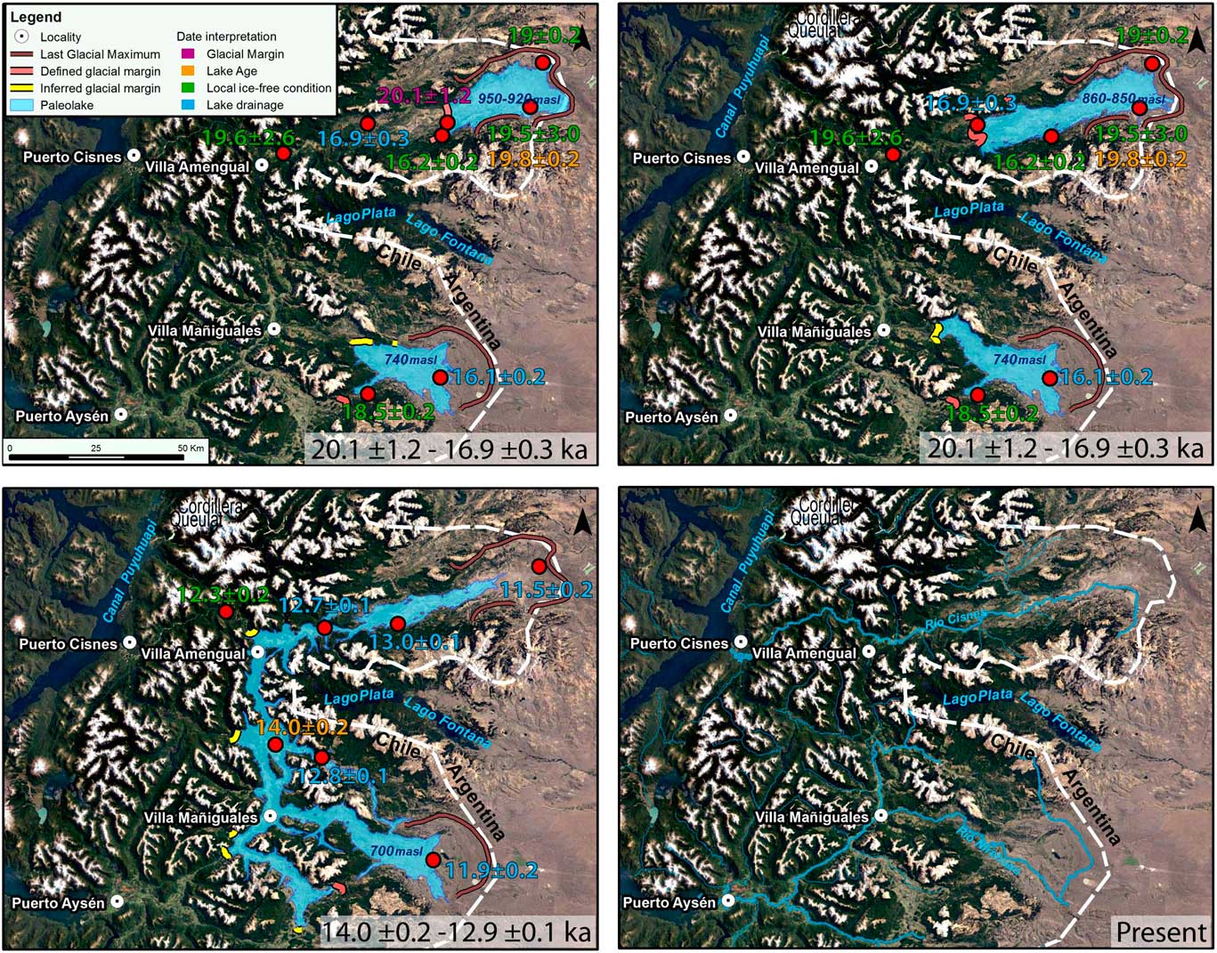
Based on the elevation and geomorphic expression of shorelines (e.g., size, distribution, and presence within the valley), we identify three main deglacial paleolake phases: high phase (950–920 m asl), intermediate phase (860–850 m asl), and low phase (850–600 m asl). The existence of lake levels at lower elevations is likely, but we did not find concordant shorelines. The ice-dammed lakes existed until Río Cisnes Glacier abandoned the Andes valleys at the end of the deglacial process and drainage was diverted from the Atlantic toward the Pacific Ocean through the Río Cisnes (Fig. 9).
Schema showing the evolution of deglacial paleolakes between the Río Cisnes and Río Aysén basins following the demise of the Patagonian Ice Sheet. The figure displays key dates used to constrain the timing of each paleolake phase. “Defined glacial margin” (red lines) designates a moraine crest, whereas “inferred ice margin” (yellow lines) refers to an ice position during overall deglaciation. (For interpretation of the references to color in this figure legend, the reader is referred to the web version of this article.)

Figure 9 synthesizes our interpretation of the paleolakes phases, associated outlets, and the time frame for their occurrence as based on the available chronological control. Because both shorelines at 950–920 m and 860–850 m are conspicuous and widespread within the valley, we link them with an outlet elevation control and/or ice front stabilization during deglaciation (Turner et al., Reference Turner, Fogwill, McCulloch and Sugden2005; Hein et al., Reference Hein, Hulton, Dunai, Kaplan, Sugden and Xu2010). Our interpretation is that the high phase and intermediate phase paleolakes occurred when ice readvanced and stabilized at CIS IV and CIS V ice marginal positions, respectively, between 20.1±1.2 ka and 16.9±0.3 ka. The OSL ages of sediments from perched deltas, however, do not agree with this time range, either being too old (Carlota site) or too young (Winchester site). For the reasons stated in the “Results” section, we interpret the OSL age of the Carlota site as a maximum age and infer that the age determined for the Winchester site is not representative for the depositional event of the formation of the beach berm.
The high phase lake at 950–920 m asl extended across the area between CIS II and CIS IV moraines. It drained eastward to the Atlantic Ocean through a well-developed 920 m spillway channel eroded into the CIS II and CIS I moraines. We calculate a maximum depth of ~350 m for this lake phase.
The intermediate phase at 860–850 m asl developed when ice stood at the inboard CIS V moraine before 16.9±0.3 ka. The lack of an outlet at this elevation suggests this lake did not drain to the Atlantic Ocean. The 860–850 m lake reached a similar depth as the 950–920 m lake at its deepest part (350 m). The intermediate phase ceased when ice retreated from the CIS V moraine by 16.9±0.3 ka.
The low phase is represented by the sequence of shorelines between 850 and 600 m asl, which imply a steadily dropping lake we link to ice retreat and thinning after 16.9±0.3 ka. The implication is that the lake level dropped as a consequence of extensive ice retreat to the west, as indicated by concurrent ice-free conditions at middle Río Cisnes as recorded by our OSL ages. Multiple corresponding shorelines at similar elevations between ~740 and 600 m occur at Cisnes and Ñirehuao valleys and represent the low phase. After a paleolake at 740 m formed in Ñirehuao and drained to the Atlantic Ocean early in the deglaciation (Fig. 9), the Río Ñirehuao Glacier retreated and allowed an extensive multibasin glacial lake to form. In this manner, the low phase defines a united lake that formed as soon as the respective ice lobes opened the pass between both valleys (i.e., the main north–south valley used today by the Carretera Austral road; Fig. 9).
We tentatively link this lake phase to ice stabilization during the ACR. Cold and wet conditions have been recorded at the Archiépelago de los Chonos and Península Taitao (46°S) during the ACR and linked to Patagonian glacier advances (Bennett et al., Reference Bennett, Haberle and Lumley2000; Siani et al., Reference Siani, Colin, Michel, Carel, Richter, Kissel and Dewilde2010; Montade et al., Reference Montade, Nebout, Kissel, Haberle, Siani and Michel2013). In fact, a recent study has directly dated moraines to the ACR at the nearby Mount San Lorenzo (47°S) (Sagredo et al., Reference Sagredo, Kaplan, Araya, Lowell, Aravena, Moreno, Kelly and Schaefer2018). The age of 14.0±0.2 cal ka BP for the charcoal embedded in glaciolacustrine sediments at Campo Grande site (300 m asl) together with the basal age of 12.8±0.1 cal ka BP for drainage of the glacial paleolake below 700 m at Mallín El Toqui indirectly bracket the timing of a glacial lake phase during the ACR. The implication is that ice had stabilized west of El Toqui valley, which was flooded by a lake above 700 m asl during the ACR. We assume that Río Cisnes Glacier just north behaved in a similar way. After extensive retreat by 16.9±0.3 cal ka BP, Río Cisnes Glacier front stabilized or halted its retreat rate at the lower Río Cisnes and allowed an interconnected lake including Río Cisnes, El Toqui, and Ñirehuao valleys to form during the ACR. Drainage of this regional lake occurred by 12.8 cal ka BP at the end of the ACR. At this time, the Mallín El Embudo in Río Cisnes valley (686 m asl; De Porras et al., Reference De Porras, Maldonado, Quintana, Martel-Cea, Reyes and Méndez2014) together with Mallín El Toqui (705 m asl) show a transition to either local subaquatic or subaerial conditions (i.e., peat deposits) recording the glacial lake level dropping below 700 m asl. Río Cisnes Glacier continued retreating, and the steady lake level dropped to below 600 m asl by 12.7±0.07 cal ka BP as recorded at La Antena site and then below 200 m asl by 12.3±0.2 cal ka BP, as recorded at Las Mellizas.
Two potential issues arise with our interpretation of a 700 m regional paleolake during the ACR. First, we do not find any distinct shorelines at this elevation, but rather multiple lake beaches between 800 and 600 m asl at Cisnes and Ñirehuao valleys. Second, the transition from subaqueous to subaerial conditions at Lago Junco by 16.9±0.3 ka occurred much earlier than at Mallín El Embudo and Mallín El Toqui, despite their similar elevations (~700 m asl). The small rocky watershed enclosing Lago Junco occurs above 700 m asl on a hilly northern valley shoulder separated from the main Río Cisnes valley. We suggest the topographic setting isolated this site from the nearby lake. In fact, the enclosed hydrologic setting at Lago Junco was used as a reason to select this as a sediment/pollen stratigraphic site. Therefore, our preferred interpretation is a deglacial lake at ~700 m that did not reach the Lago Junco site but flooded Mallín El Embudo and Mallín El Toqui.
The timing and evolution of Río Cisnes Glacier paleolake history proposed here is in agreement with that interpreted for Lago Cochrane Glacier and Lago General Carrera Glacier during the last glacial-interglacial transition (Turner et al., Reference Turner, Fogwill, McCulloch and Sugden2005; Bell, Reference Bell2008; Hein et al., Reference Hein, Hulton, Dunai, Kaplan, Sugden and Xu2010; Horta et al., Reference Horta, Georgieff and Aschero2015), although precise timings vary from basin to basin and more chronological data are required. The high lake phase at Lago Cochrane ended by 19.5 ka when the glacial paleolake seems to have dropped 150 m from its highest level, as recorded in Río Chacabuco valley (Henríquez et al., Reference Henríquez, Villa-Martínez, Vilanova, De Pol-Holz and Moreno2017). The lower united lake phase between Lagos Cochrane and General Carrera draining through the Río Deseado outlet to the Atlantic Ocean has been constrained by 14C and 10Be dating between ca. 13.6 and 12.8 ka, in agreement with the ACR timing we have defined for the low phase (Turner at al., Reference Turner, Fogwill, McCulloch and Sugden2005; Hein et al., Reference Hein, Hulton, Dunai, Kaplan, Sugden and Xu2010). Total drainage of the united Cochrane and General Carrera paleolake occurred by 12.8 ka as a catastrophic lake discharge after the separation of the Northern and Southern Patagonian Ice Fields (Turner et al., Reference Turner, Fogwill, McCulloch and Sugden2005). This date marks a key moment in the deglaciation, when Patagonian ice resumed the retreat interrupted by the ACR stabilization or readvance recorded elsewhere (e.g., Strelin et al., Reference Strelin, Denton, Vandergoes, Ninnemann and Putnam2011; García et al., Reference García, Kaplan, Hall, Schaefer, Vega, Schwartz and Finkel2012; Sagredo et al., Reference Sagredo, Kaplan, Araya, Lowell, Aravena, Moreno, Kelly and Schaefer2018). After 12.8 ka, the Northern Patagonian Ice Field outlet glaciers continued with a stepwise retreat until the very end of the last glacial-interglacial transition (Glasser et al., Reference Glasser, Harrison, Schnabel, Fabel and Jansson2012).
Paleoclimate
Evidence suggests that deglaciation started before 19 ka in some parts of Patagonia. Here, we inspect paleoclimate mechanisms that can account for this deglacial trend before the traditionally assumed start of the Patagonian termination at 17.8 ka. The CO2 rise, thought to play an important role in bringing the earth out of the last ice age (Denton et al., Reference Denton, Anderson, Toggweiler, Edwards, Schaefer and Putnam2010), did not occur until 18 ka (Monnin et al., Reference Monnin, Indermühle, Dällenbach, Flückiger, Stauffer, Stocker, Raynaud and Barnola2001), so it causal effect could not be linked to glacial retreat before this time. Nonetheless, widespread atmospheric and surface ocean warming trends recorded at middle and high latitudes, including West Antarctica, accompanied the retreat of Patagonian glaciers before 19 ka (Fig. 10). For instance, between ca. 23.5 and 19.5 ka, arboreal pollen was increasing and Nothofagus dombeyi type dominated the pollen assemblages in the Chilean Lake District and Isla Grande de Chiloé, on the west side of the Patagonian Andes (Fig. 10; Heusser et al., Reference Heusser, Heusser and Lowell1999; Moreno et al., Reference Moreno, Denton, Moreno, Lowell, Putnam and Kaplan2015). Mean summer air temperature increased ~2–3°C, in a time of rapidly shifting climatic conditions within the global LGM chronozone (Heusser et al., Reference Heusser, Heusser and Lowell1999). The culmination of this warming period was named the Varas interstade (Mercer, Reference Mercer1972), recently reexamined by Denton et al. (Reference Denton, Lowell, Heusser, Schlüchter, Andersen, Heusser, Moreno and Marchant1999) and Moreno et al. (Reference Moreno, Denton, Moreno, Lowell, Putnam and Kaplan2015) in the Chilean Lake District. At this time, Lago Llanquihue Glacier (41°S) retreated from its maximum extent, and proglacial meltwater channels were abandoned (Denton et al., Reference Denton, Lowell, Heusser, Schlüchter, Andersen, Heusser, Moreno and Marchant1999). Offshore from the Pacific southern Andes at 41°S and 53°S, the sea surface temperatures reveal a millennial-scale warming of about 2°C at ca. 22–20 ka (Lamy et al., Reference Lamy, Kaiser, Ninnemann, Hebbeln, Arz and Stoner2004; Caniupán, Reference Caniupán, Lamy, Lange, Kaiser, Arz, Kilian and Baeza Urrea2011; Fig. 10). The same warming trend is found for the South Atlantic (Barker et al., Reference Barker, Diz, Vautravers, Pike, Knorr, Hall and Broecker2009; Fig. 10). In West Antarctica, the West Antarctic Ice Sheet (WAIS) Divide Ice Core (WDC) (79°S) δ18O record shows a significant warming trend starting at least by 20 ka, coincident with the South Atlantic sea ice decline between 22 and 18 ka (Collins et al., Reference Collins, Pike, Allen and Hodgson2012; WAIS Divide Project Members, 2013; Fig. 10).
(color online) Paleoclimate context for the early deglaciation of Río Cisnes glacier. (a) Río Cisnes Glacier retreat history as based on Cisnes (CIS) moraines (this study). Distance is calculated taking into account the highest topographic axis of the Andes and moraine CIS II. (b) Arboreal pollen record in the Chilean Lake District as a proxy for mean air temperature (Moreno et al., Reference Moreno, Denton, Moreno, Lowell, Putnam and Kaplan2015). (c) Sea-surface temperatures in southeast Pacific Ocean (Ocean Drilling Program Site 1233) inferred from Globigerina bulloides δ18O (Lamy et al., Reference Lamy, Kaiser, Ninnemann, Hebbeln, Arz and Stoner2004). (d) Ocean-water temperatures as inferred from polar foraminiferal species in the South Atlantic (core TNO57–21) (Barker et al., Reference Barker, Diz, Vautravers, Pike, Knorr, Hall and Broecker2009). (e) Annual-mean surface air temperature at West Antarctic Ice Sheet (WAIS) Divide Ice Core (WDC) as inferred from δ18O of ice (WAIS Divide Project Members, 2013). The vertical gray dashed line indicates the approximate start time when mid- to high paleoclimate proxies record warming trends.

Cumulatively, these terrestrial and oceanic paleoclimate multiproxy records suggest that a mid- to high-latitude warming spanning at least 40° latitude started at 22–23 ka and culminated at 19.5 ka, coincident with the Varas interstade in the Chilean Lake District. This warming triggered deglacial retreat of sensitive Patagonian glaciers, which never returned to their LGM position. Nonetheless, this was not the case for a number of glaciers in Patagonia, which only collapsed into the Andes after ca. 18 ka. For instance, Chilotan Piedmont Glacier on the western side of the Andes at 42°S readvanced to its LGM margin in the Isla de Chiloé at 17.9±0.2 ka after the Varas interstade (Denton et al., Reference Denton, Lowell, Heusser, Schlüchter, Andersen, Heusser, Moreno and Marchant1999), when the southern westerlies were at its northern LGM position (Heusser et al., Reference Heusser, Heusser and Lowell1999). This glacier record reveals an opposite PIS trend between the western and eastern Patagonian Andes if Chilotan Piedmont and Cisnes glaciers are compared. Pollen records (Heusser et al., Reference Heusser, Heusser and Lowell1999; Markgraf et al., Reference Markgraf, Whitlock and Haberle2007; De Porras et al., Reference De Porras, Maldonado, Abarzúa, Cárdenas, Francois, Martel-Cea, Stern, Méndez and Reyes2012) show climate conditions that are wetter and drier than present on the western and eastern sides of the Andes, respectively, helping explain this mountain-side dependent, out-of-phase glacier response. Drier conditions on the eastern Andes in the Río Cisnes catchment should have limited glacial extent in Río Cisnes by ca. 18 ka. Other Patagonian glaciers such as those in the Lago Buenos Aires and Strait of Magellan, together with those in the lake district, only started deglaciation after 18 ka (McCulloch et al., Reference McCulloch, Bentley, Purves, Hulton, Sugden and Clapperton2000, Reference McCulloch, Fogwill, Sugden, Bentley and Kubik2005; Kaplan et al., Reference Kaplan, Fogwill, Sugden, Hulton, Kubik and Freeman2008; Bendle et al., Reference Bendle, Palmer, Thorndycraft and Matthews2017; Hall et al., Reference Hall., Denton, Lowell, Bromley and Putnam2017), which could be explained by the greater amount of ice loss needed to evacuate these basins. There is widespread evidence that at 18 ka Patagonian deglaciation reached a critical point with extensive ice retreat occurring in the region. At this time, the southern polar hemisphere shows its highest warming rates accompanied by rapid increase in atmospheric CO2 (Monnin et al., Reference Monnin, Indermühle, Dällenbach, Flückiger, Stauffer, Stocker, Raynaud and Barnola2001; Lemieux-Dudon et al., Reference Lemieux-Dudon, Layo, Petit, Waelbroeck, Svensson, Ritz, Barnola, Narcisi and Parrenin2010; WAIS Divide Project Members, 2013).
In summary, the initial step of Patagonian deglaciation occurred before 19 ka, following a widespread mid- to high-latitude warming trend, enhanced by local aridity. Although some glaciers showed extensive retreat at this time and never recovered, other glaciers readvanced to full glacial extent until the very end of the LGM at 18 ka, giving a short-term asymmetry of Patagonian glacier responses to the deglacial signal. The close paleoclimate link between the WDC and some Patagonian glacier records exposes the sensitivity of both sites to the changes in the Southern Ocean sea surface temperatures and sea ice extent, ultimately controlled by local insolation (WAIS Divide Project Members, 2013), and thereby suggesting a paleoclimate teleconnection between mid- and high latitudes (e.g., Kaplan et al. Reference Kaplan, Fogwill, Sugden, Hulton, Kubik and Freeman2008; Denton et al., Reference Denton, Anderson, Toggweiler, Edwards, Schaefer and Putnam2010; WAIS Divide Project Members, 2013; Darvill et al., Reference Darvill, Bentley, Stokes and Shulmeister2016; García et al., Reference García, Hein, Binnie, Gómez, González and Dunai2018).
CONCLUSIONS
We have provided geomorphic, stratigraphic, and geochronological evidence in support of the following conclusions.
Retreat of Río Cisnes Glacier from LGM extents was already underway before 19 ka. This early deglaciation, if compared to the normally assumed start of deglaciation in Patagonia at ca. 18 ka, can be linked to a decline of Southern Ocean sea ice and Antarctic atmospheric warming (WAIS Divide Project Members, 2013).
The demise of Río Cisnes Glacier was punctuated by multiple ice readvances and stabilizations throughout the last glacial-interglacial transition, such as at 20.1±1.2 ka and between 20.1±1.2 and 16.9±0.3 ka. Stabilization of Río Cisnes Glacier during the ACR between 14.0±0.2 and 12.8±0.1 ka is mostly demonstrated. Regional paleolake drainage and extensive landscape change under subaerial conditions occurred at the end of this period.
We distinguish three paleolake phases during the overall Río Cisnes Glacier deglaciation. The high and intermediate phases occurred between 20.1±1.2 ka and 16.9±0.3 ka, and the low paleolake phase between 14.0±0.2 and 12.8±0.1 ka, when a lake formed among the neighboring Cisnes-Toqui-Ñirehuao valleys before final disintegration of the PIS at 44–45°S.
Supplementary material
To view supplementary material for this article, please visit https:/doi.org/10.1017/qua.2018.93
Acknowledgments
This research was funded by FONDECYT #1161110, FONDECYT #1130128, National Geographic Society #HJ-150R-17, Programa Regional CONICYT R17A10002 grants. We are very grateful to Stephanie Buckaert (Estancia Río Cisnes), Bernd Von Malapert (Estancia Las Quemas), and Claudio Bariggi, Robinson Palma, and Freddy Boldt (Estancia Baño Nuevo) for permissions and support for fieldwork. We thank Tomás Rojo, Tomás Carmona and Constanza Maldonado for assistance during field campaigns. We thank Pilar García for help with constructing Figure 2. We also want to thank associate editor Dr. Shulmeister and an anonymous reviewer for valuable comments.