BERKSHIRE
(1) Arborfield: (a) Farley Hall Estate (SU 7440 6714): the evaluationFootnote 407 of an area of almost 2 sq km revealed the presence of a modest range of archaeological deposits of later prehistoric and early Roman date on both sides of the river Loddon. Although the remains were not extensive, it is considered that they reflect the presence of three or four Roman farmsteads.Footnote 408
(b) Arborfield Garrison, Parcel VI (SU 77251 66066): evaluation found a short stretch of Roman ditch, aligned north-west–south-east, in the south-western part of the site. This contained a quantity of Alice Holt/Surrey ware pottery dated a.d. 50–80.Footnote 409
(c) Arborfield Garrison, Parcel VI (SU 77087 66013): evaluation found a ditch, aligned north-west–south-east, of possible late Iron Age or early Roman date.Footnote 410
(2) Bracknell, Amen Corner (SU 8377 6932): an evaluation found a boundary and/or drainage ditch dating from the late Iron Age to early Roman period, representing the continuation of the early to mid-Iron Age activity identified on the site. An additional four ditches were identified, although no dating evidence was recovered from these.Footnote 411
(3) Slough, land to the south of Kings Reach, Ditton Park (SU 9922 7860): excavation revealed an area of later Iron Age and Roman enclosures. The most significant discovery was the finding of Anglo-Saxon deposits including two sunken-floored buildings. Radiocarbon dating of residues on one vessel returned a date within the fourth century with a second sample returning a date of late fourth/fifth century, suggesting that Anglo-Saxon colonisation of the valley was underway before the conventional end of Roman Britain in a.d. 410.Footnote 412
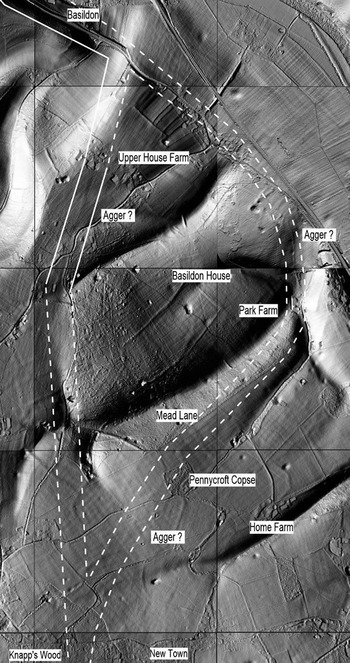
(4) Ufton Nervet, Ufton Bridge to Mayridge Farm (SU 622 688–615 706), Bradfield, Englefield Bournefield Farm to Knapp's Wood (SU 612 716–604 756), Basildon Mead Lane to Upper Basildon (SU 604 756–612 785): Lidar imagery and fieldwork have shown that the alignment of the Roman road north from Silchester to Dorchester on ThamesFootnote 413 continues directly NNW towards Basildon and the Streatley gap where the Thames cuts through the Berkshire Downs. The road terrace and a road cutting through a spur of the ridge west of Mayridge Farm take a curving route over the ridge that is visible on Lidar and can be traced on the ground. Beyond Mayridge there is clear Lidar evidence for the road through Bradfield, Upper Basildon and Basildon (fig. 40). Traces of road cuttings survive on the west side of the ridge, by Bournefield Farm, by Hill Plantation east of Bradfield and east of Barnelms Farm. Pieces of agger survive in Kiln Copse and on the floodplain of the Pang.
Ufton Nervet: Lidar image of Roman road alignment through Kiln Copse.

Beyond the M4 the Lidar shows traces of an agger in Great Bear Wood east of Herons Farm and south of Knapp's Wood. Beyond Upper Basildon there are two features on the Lidar imagery that could be the agger of the road (fig. 41). The most likely route is that curving north-east from Knapp's Wood to run into Mead Lane and descend into the Thames Valley through a side valley past Park Farm. There are traces of agger visible on this line. Through the park of Basildon House there is a terrace and agger visible on Lidar, converging with the modern A329 north of the house and running on to Streatley.Footnote 414
Ufton Nervet: Lidar image of Roman road alignment curving east from Knapps Wood.

(5) Water Oakley, Water Oakley Farm (SU 915 773): evaluation of 70 trenches and 24 test-pits covered an area of 57 ha. Forty-eight of the 70 trenches were devoid of any archaeological features. Two distinct areas of archaeological activities consisting of linear ditches, pits (one containing a cremation) and post-holes (two containing pyre debris) were identified. The two areas probably represent two separate low-status small farmsteads with enclosures and associated field-systems that developed from the late Iron Age through the early Roman period up to the second century.Footnote 415
(6) Whitley, The Ridgeway School (SU 7295 7035): evaluation trenching and subsequent excavation revealed that the site was used extensively during the Roman period, with enclosures remodelled on several occasions until final use in the third century. A notable discovery was a coin hoard dating from c. a.d. 274, coinciding with the abandonment of the site.Footnote 416
(7) Wokingham, Matthewsgreen Farm, Twyford Road (SU 8030 7015 and SU 8064 6972): excavations revealed a modest complex of enclosures dating from the late Iron Age into the early Roman period. Charred plant remains were few and facilities for processing and storing arable production absent, leading to the suggestion that the site had a dominant pastoral emphasis. The site had gone out of use by the late third or early fourth century which adds to the emerging local pattern in which there are numerous late Iron Age/early Roman settlements but a dearth of late Roman examples.Footnote 417
WEST SUSSEX
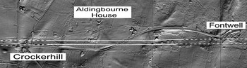
(1) Aldingbourne, Aldingbourne House (SU 924 070–SU 940 070): Lidar and aerial photographic imagery have revealed definitive evidence for the line of the Roman road between Chichester and Arundel,Footnote 418 running through the grounds of Aldingbourne House where the terrace is visible on Lidar imagery from SU 924 070 to SU 935 070, and continuing east of the A27 to SU 940 070 (fig. 42). The road can be distinguished on the ground but the remains are very faint. Cropmarks of the side ditches of the road 13 m apart are visible on Google Earth imagery at SU 933 070.Footnote 419
Aldingbourne: Lidar image of the Roman road alignment between Fontwell and Crockerhill.

(2) Crawley, land east of Emmanuel Cottage, Resuper Road, Ifield (TQ 24367 36835): trial-trenching identified a boundary ditch containing Romano-British pottery and a second ditch containing slag which may be of Romano-British origin. Further unstratified finds including greyware pottery were also recovered.Footnote 420
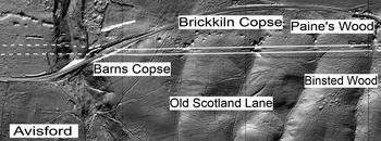
(3) Tortington, Barn's Copse, Brickkiln Copse and Paine's Wood (SU 979 070–SU 997 071): immediately east of the A27 the agger of the Roman road becomes visible on Lidar in Barn's Copse and then continues intermittently through Brickkiln Copse and Paine's Wood (fig. 43). On the ground the remains are clear but difficult to locate in the dense undergrowth. Immediately east of Barns Copse the side ditches of the road are again visible on Google Earth imagery in the field south of the A27 at SU 982 070. Within Paine's Wood one length of road survives in dense woodland where the agger and side ditches are particularly clear both on Lidar and on the ground at SU 994 071. At SU 997 071 the Roman road converges with the metalled track known as Old Scotland Lane and east from here there are no certain traces of Roman construction. Lidar imagery of the area south and south-east of Arundel provides no clues as to the line of the Roman road beyond here.Footnote 421
Tortington: Lidar image of Roman road route through Brickkiln Copse and Paine's Wood.

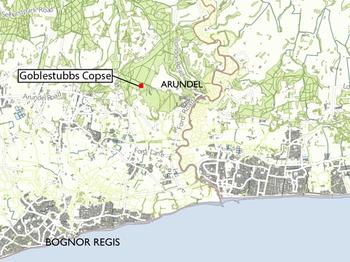
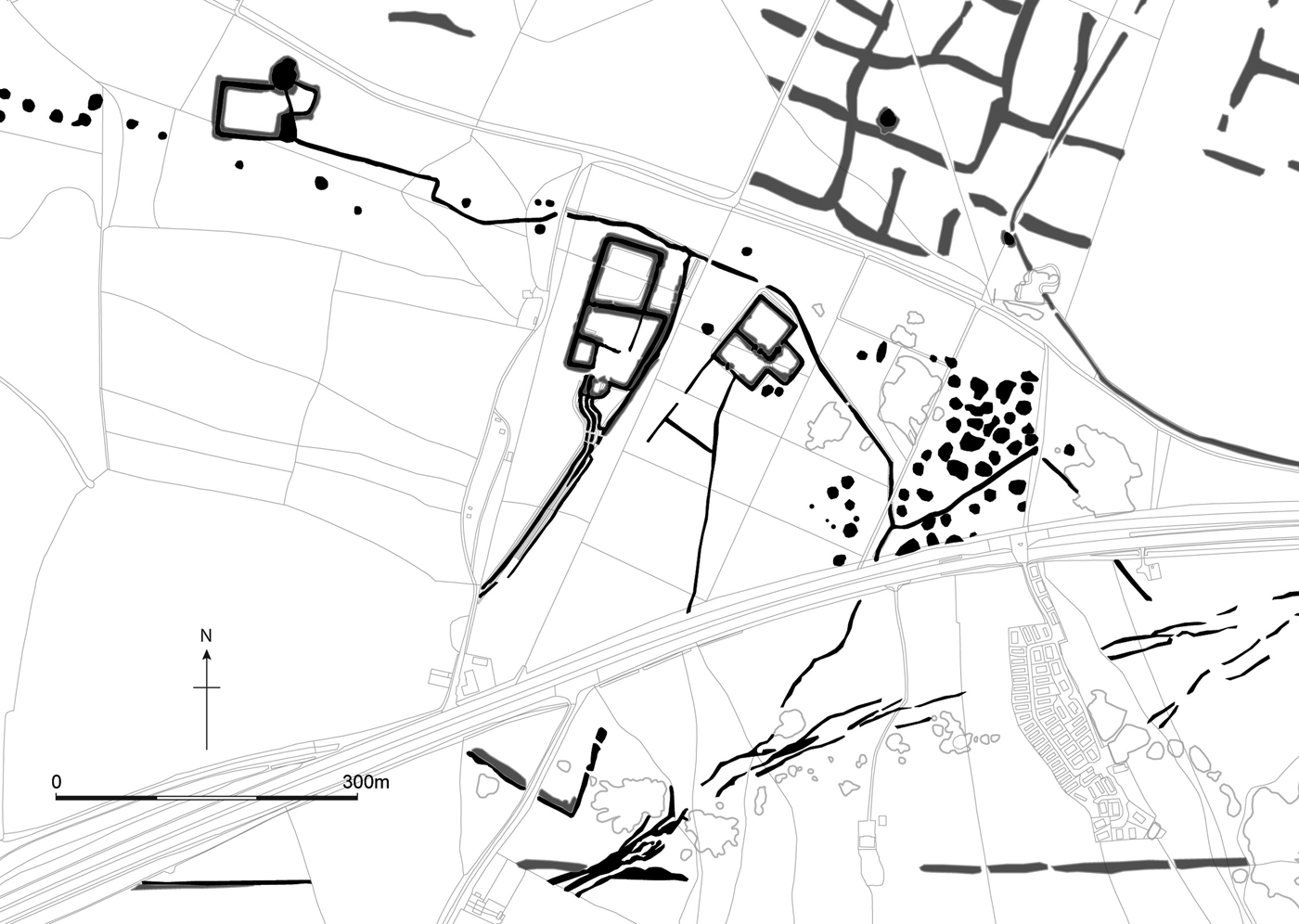
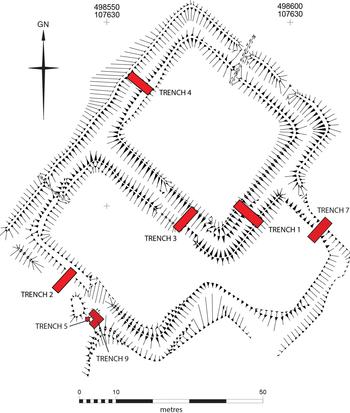
(4) Walberton, Goblestubbs Copse East, Walberton (SU 9858 0757): the Goblestubbs Copse enclosure complex is situated within dense woodland 2 km to the north-west of Arundel (fig. 44). Work by the CurwensFootnote 422 revealed it was one of a number of similar complexes within an area of a few square kilometres, each comprising a multiple-ditched enclosure, linear earthworks, tracks and boundaries, all enclosed within the War Dyke which extends from the Arun to the north of Arundel, in a south-westerly loop, enclosing an area in excess of 20 square kilometres. Recent Lidar survey, which formed the basis of the South Downs National Park Authority's Secrets of the High WoodsFootnote 423 project, shows that the enclosures lie close to a previously unknown hillfort of middle Iron Age date and are surrounded by extensive tracts of co-axial field-system. The Goblestubbs Copse enclosure complex itself is made up of two elements (fig. 45). The western elementFootnote 424 is a Scheduled Monument and consists of at least two phases of enclosure associated with a triple-ditch system, thought to be an early Roman military construction.Footnote 425 The eastern element at Goblestubbs sits outside the Scheduled area, and comprises a square enclosure with annexes to the south-west and south-east. ExcavationsFootnote 426 indicated that the earliest enclosure here pre-dated that to the west, with little overlap in occupation. Consequently, further work was undertaken to assess whether any overlap existed between the western and eastern elements. Seven trenches were excavated (fig. 46) revealing that the ditches were contemporary and part of the same ‘unit’. The Lidar survey revealed additional detail including lynchet field boundaries which appear to underlie the enclosure, as well as ditched trackways. Further trenches (Trenches 5 and 9) were positioned at the intersection of a hollow way and possible entrance break on the south side of the enclosure. The track proved to be at least 5.5 m wide and was constructed using flint cobbles as a foundation. Sand-tempered pottery found during the recent excavation indicates the eastern enclosure was constructed at the beginning of the first century, then abandoned during the early part of the third quarter of that century. The pottery from the eastern enclosure can be viewed as prototypes of local forms dating to the early Roman period. The excavation of the Goblestubbs enclosures has led to a reassessment of the importance of the Arundel area during the late Iron Age to Roman transition and, in particular, the significance of the river Arun as a communication and transport link during the decades leading up to, and following, the Claudian invasion. When viewed in conjunction with the Arun, the War Dyke can be seen to delineate a precise area, defining a separate enclave with its communal centre close to Arundel.Footnote 427
The Goblestubbs complex is located in woodland to the west of Arundel, West Sussex. The enclosures have been constructed on a gravel terrace overlooking the Sussex coastal plain. (Figure produced by Worthing Archaeological Society)

Extract of mapping from Lidar of late Iron Age/Roman settlement enclosures and trackways amongst earlier fragmented field-systems in the vicinity of Goblestubbs Copse. The course of the rediscovered route of the Roman road from Chichester to Arundel passes east–west to the south of the site. Ditches are shown in black, banks in grey. (Mapping © Historic England. Base map © Crown Copyright and database right 2016, all rights reserved. Ordnance Survey licence number 100024900. Figure produced by Worthing Archaeological Society)

Earthwork survey of the Goblestubbs Copse East enclosure complex, and the location of the excavation trenches. (Figure produced by Worthing Archaeological Society)

EAST SUSSEX
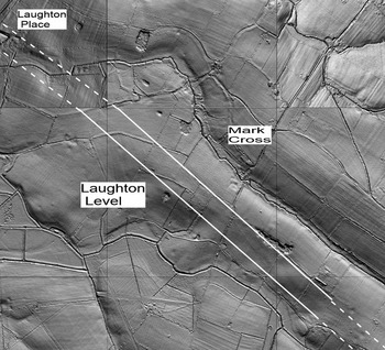
(1) Arlington, Thornwell Cottage (TQ 565 058–552 064), Highfield (TQ 522 082–516 086), West Firle, Laughton Level (TQ 503 098–490 109), Ringmer, Moorland Farm (TQ 475 121–466 126): Lidar imagery has confirmed the line of a Roman road between Pevensey and the defended Roman enclosure at Upper Wellingham, in four locations (fig. 47). The road then continues westwards to Hardham on Stane Street as the Sussex Greensand Way;Footnote 428 it may be a Roman military road from the early days of the conquest, probably laid out on three alignments: Pevensey to Polegate, Polegate to Arlington and Arlington to Wellingham. The Lidar imagery shows the agger running past Moorland Farm and across Laughton Level past Mark Cross to Wellingham.Footnote 429
Arlington: Lidar image of Roman road alignment south of Mark Cross.

(2) Littlehampton, land at Toddington Lane (TQ 0305 0412): continuing evaluation revealed numerous features dating from the Bronze Age, Iron Age and Roman periods, to add to those from previous work in the area.Footnote 430
(3) Peacehaven, 2 South Coast Road (TQ 42544 00678): evaluation revealed evidence for a possible late Iron Age to early Roman farmstead with an enclosure ditch. The features comprised a series of post-holes, a fire pit/hearth, a beam-slot, internal and external beaten earth surfaces, a number of rubbish pits and boundary ditches, one of which was curvilinear.Footnote 431
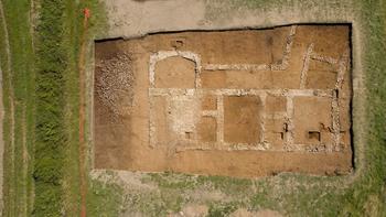
(4) Plumpton, Plumpton College (TQ 360 147): research and training excavations continued from 2015.Footnote 432 The trench revealed the remainder of the western half of the winged-corridor house, including more of the south-facing corridor which fronted part of a line of three main rooms separated by sub-divided passages or narrow rooms. In contrast to the eastern end of the corridor, the western end turned and continued to the south-west beneath the edge of the trench, without an elaborate wing-room (fig. 48). It is now clear that the original masonry building comprised a rectangular block of five rooms, possibly connected by a south-facing corridor of timber.Footnote 433
Aerial view of Plumpton Roman villa in 2016, south at the top (scales: 2 m). (Photograph: Mark Dobson)

(5) Ringmer, The Orchards, Uckfield Road (TQ 4414 1383): evaluation recorded flint nodules in two trenches, possibly the Roman road from Arlington to Barcombe. Although the line of the road appears to be visible as a slightly raised area, the feature has been severely affected by ploughing and/or robbing.Footnote 434
SURREY
(1) Bix and Assendon: hoard of 12 silver denarii: 2 of Vespasian (a.d. 69–79); 1 each of Domitian Caesar and Domitian (a.d. 81–96); 3 each of Hadrian (a.d. 117–38) and Antoninus Pius (a.d. 138–61); 1 each of Diva Faustina I and Marcus Aurelius (a.d. 161–80) for Lucilla. Date of deposition c. a.d. 164.Footnote 435
(2) Leigh: 2 silver denarii: 1 of Nero (a.d. 54–68), 1 of Divus Antoninus Pius (a.d. 161), additional to earlier finds. The total now stands at 76 denarii together with pottery and bronze fragments. Date of deposition c. a.d. 180.Footnote 436
(3) Staines-upon-Thames, 90–106 High Street (TQ 0262 7171): an evaluation uncovered late Roman features in two trenches located in the southern portion of the site. These consisted of a ditch and a gully, both aligned north–south, a rubbish pit, and a possible ditch/pit. While the pottery assemblage dated to a.d. 350–400, residual finds recovered during the excavation of medieval features and deposits included material dating from the early to the late Roman period. The ceramic building material assemblage is of particular note as there was a near total dominance of the common London sandy 2815 group dating to a.d. 50–160, the use of which so far out of central London can only be attributed to the transportation of tile and brick by barge or boat upstream along the Thames. Early bath-house material was also present in the form of a knife-scored box-flue tile, common in the mid- to late first century in central London, and a possible roller-stamped die which could not be matched with the existing catalogue. This may suggest the possibility of an early Roman bath-house located in the vicinity of the site.Footnote 437
KENT
(1) Canterbury (Durovernum Cantiacorum): (a) South Precincts, Canterbury Cathedral (TR 14997 57862): evaluation revealed traces of a Roman building. A combination of auguring and excavation suggested the presence of pit fills, floors, metallings and deposits indicative of a prolonged period of Roman occupation. An in-situ tessellated floor was overlain by demolition material containing fragments of painted wall-plaster and mortar. A robber trench associated with the tessellated floor possibly indicated the south-west wall of a room in a building bordering a street which, based on excavation in the nave of the cathedral,Footnote 438 ran on a north-east–south-west alignment east of the new Welcome Centre.Footnote 439
(b) Mitchinson House, King's School (TR 15100 58113): evaluationFootnote 440 recorded metallings relating to the most northerly decumanus of the early street-grid.Footnote 441
(c) 16 St Radigund's Street (TR 15017 58234): evaluation recorded residual Roman material throughout early peat and marshland deposits. The sole feature consisted of a 0.4 m thick dense packing of large flints set in clay with associated tile, large chalk blocks, mortar and a few fragments of samian. The feature was capped by a sandstone slab, 0.5 m wide, which may represent an early attempt to consolidate soft marsh deposits.Footnote 442
(d) 6a St Peter's Lane (TR 14770 58080): a watching-brief Footnote 443conducted during geotechnical/contamination site investigation observed dump deposits and a clay floor or bedding overlain by a light metalling or tread. The deposits extend the area of known Roman building(s) previously identified on adjoining sites.Footnote 444
(e) Westgate Gardens (TR 14360 57850, centred): further excavation uncovered more of a ‘courtyard’ surface for a building associated with the early Roman grid system in an area that became extramural c. a.d. 270–90 after the construction of the town wall; the final (rough) road metalling was found to have shifted to overlie the earlier surface.Footnote 445
(f) Former HM Prison, Longport (TR 15725 57760): evaluationFootnote 446 recovered a small amount of Roman material and a pit, linear feature and stake-holes, potentially representing a continuation of known activity immediately south-west of the site.Footnote 447
(g) Barton Court Grammar School, Longport (TR 15689 57550): excavationFootnote 448 uncovered two collapsed ovens which have been dated to the Roman period.
(2) East Farleigh, Oaklands, Lower Road (TQ 7280 5359): trial-pits on the east side of the site located foundations of an unknown building, c. 6 m square and built of mortared ragstone. Boundary walls abut the north and south sides. Ditches to the east of the previously discovered barn were also explored. Investigations are due to continue during 2017.Footnote 449
(3) Folkestone, Shorncliffe Garrison (TR 19615 36358): excavation identified a Romano-British field boundary and pit.Footnote 450
(4) Gravesend, land south of Dalefield Way (TQ 67084 73369): 44 evaluation trenches were excavated. Only one contained archaeology, a substantial ditch, 2.5 m wide and 1.15 m deep, containing Romano-British pottery. This isolated feature suggests significant activity somewhere in the area.Footnote 451
(5) Harrietsham, land at Bell Farm (TQ 87122 52559): 21 trial-trenches contained archaeology that demonstrated a long history of agricultural use from the Iron Age to the modern period; enclosure ditches, field boundaries and pits were identified. Two of the field boundaries date to the Iron Age/Romano-British periods.Footnote 452
(6) Herne Bay, Golf Course (TR 17161 66480): evaluationFootnote 453 revealed further evidenceFootnote 454 for late Iron Age/early Romano-British activity. Sample excavated features contained pottery extending up to the mid-second century, suggesting that the area forms part of a Romano-British landscape of enclosures and settlement.
(7) Kingsnorth Quarry, Hoo St Werburgh (TQ 7991 7231): strip, map and sample excavation and a watching-brief found a pit containing assorted human bones in its lower fill, sealed under an upper fill of wattle-impressed daub. Another pit, c. 50 m to the south-west, also contained a fill of wattle-impressed daub. In its lower fill was a stamped samian sherd, suggesting that both features were Roman in date.Footnote 455
(8) Lympne, Old Mill Cottage, Aldington Road (TR 11460 34960): evaluationFootnote 456 recorded a potential Roman cultivation soil cut by ditches and a gully containing first- to second-century pottery, daub and ceramic building material.
(9) Meopham, Meopham School (TQ 64250 65890): excavationFootnote 457 uncovered an inhumation burial of a child no older than four years. This was cut into the upper fill of a late Iron Age enclosure ditch. Also excavated was a large pit, possibly a sand quarry, containing Roman tile and a copper-alloy brooch.
(10) Minster: 5 silver denarii: 1 each of Vespasian (a.d. 69–79), Nerva (a.d. 96–8), Trajan (a.d. 98–117), Antoninus Pius (a.d. 138–60; minted a.d. 155–6) and Marcus Caesar (minted a.d. 146–7). Date of deposition c. a.d. 156.Footnote 458
(11) Smeeth: 2 base silver denarii and 1 copper as. Denarii: 1 of Elagabalus (a.d. 218–22), 1 of Severus Alexander (a.d. 222–35). As: Philip I (a.d. 244–9). Date of deposition c. a.d. 249.Footnote 459
(12) Stonecross, Rattle Road (TQ 62163 04289): trial-trench evaluation located a ridgeline running north-west–south-east through the approximate centre of the site, with the majority of the Romano-British features located to the north-east of this ridge. A large spread of compacted flint, probably representing a metalled surface, followed the brow of the ridge and was flanked on either side by ditches containing large fragments of quernstone and a single sherd of Romano-British pottery. Linear features formed probable field-systems of prehistoric and Romano-British date. Urned and unurned cremation burials, and possibly associated features, are mainly thought to date to the Saxon period, but at least one is Bronze Age and some are dated only through spatial association.Footnote 460
(13) Tunbridge Wells: 6 silver denarii: 1 each of Mark Antony (32–1 b.c.), Domitian (a.d. 81–96), Hadrian (a.d. 117–38), Aelius Caesar, Antoninus Pius (a.d. 138–61) for Marcus Caesar, and Marcus Aurelius (a.d. 161–80). Date of deposition c. a.d. 171.Footnote 461
(14) Upper Harbledown, Homestall Wood (TR 1175 5892): further limited investigation took place on the 35 ha polygonal enclosure, now referred to as Earthwork 1, at two points on the circuit.Footnote 462 On Site A the upper filling of the external ditch was investigated and the rampart tail sectioned. The ditch was found to be at least 10 m wide with evidence of a collapse from the bank, sealed by a flint metalled surface and later silting. A possible truncated post-setting was identified on the inner lip of the ditch. The internal bank was confirmed as c. 8 m wide, surviving to 1 m above the original ground surface and sealing a primary clay core. To the rear, open ground extended for 6 m before two features containing carbon-rich deposits were encountered. A rectangular pit may have been the stoke-hole of a surface oven. From the ground surface came an eroded amphora fragment of Campanian black-sand type fabric, similar to the Dressel 1 sherds previously found in the area. On Site E, a single trench revealed the Earthwork 1 bank, sealing a ground surface containing native grog-tempered pottery of the first century b.c. The lip of the associated ditch, which was visible on Lidar, was identified to the south. The front of the bank here appeared cut away by a trampled surface and a possible oven, the latter yielding Terra Rubra and Gallic White Wares, native imitations and local grog-tempered pottery as well as amphora sherds of the late first century b.c. and early first century a.d. Much similar material was recovered from a tree-throw and the boundary ditch. An iron object on this surface awaits X-ray but may be a pointed type of ballista bolt. This important but fragmentary sequence may provide a date for the construction of Earthwork 1 in the first century b.c. and show its partial levelling or slighting later in the century or in the early first century a.d. Surface finds from tree-throws at various points within the interior of Enclosure 1 suggest activity over a similar time period to that indicated from Site E.Footnote 463
(15) Wouldham, Wouldham All Saints Primary School (TQ 71397 63415): trial-trenches were excavated in the hope of providing more information about a probable trackway. Sandy wares recovered from a ditch flanking the track demonstrated an Iron Age or Romano-British date. A series of post-holes may represent a fence.Footnote 464