

After touring Transylvania in 1773, Joseph II, emperor of the Holy Roman Empire and co-regent of the Habsburg monarchy, wrote to Empress Maria Theresa complaining about the state of the province's economy and its administrative corruption. Such problems required urgent reform of the sort that could be carried out only by a strong, centralized government acting in the spirit of Enlightened Absolutism. However, success in these endeavors required something more. In Joseph II's words: “We have to remember that the best intentions fail often and the lack of knowledge of local realities makes such a real difference in governance, that what is often considered the best and wisest decisions, cannot be applied locally efficiently; the total ignorance of Your Majesty's advisers at the court and the Transylvanian Chancellery is a real hindrance and harm for the administration.”Footnote 1
This “total ignorance” Joseph II found not only in Transylvania, but also in his frequent travels to all corners of the monarchy as he struggled to gather accurate, first-hand information about the Habsburg domains. If he knew the problem, he also knew the answer: maps. Decision makers needed maps. It was a wise assessment, for, as Benedict Anderson has noted, maps, along with censuses and museums, shaped the way in which colonial powers imagined their dominions by creating “a human landscape of perfect visibility.”Footnote 2 In particular, maps supplied a basic visual language to depict landscapes, villages, borders, and roads. Inspired by the Enlightenment drive for numbering and categorizing, cartographers made maps easily accessible by including legends that classified and simplified their main traits. This organization of spatial knowledge provided governments with the information essential to the expansion of central authority. Maps were, then, of great practical utility, and Joseph II was not alone in recognizing their value. Indeed, throughout the eighteenth century imperial rulers in Britain, China, France, Spain, and Russia also invested extensive resources to obtain detailed visual representations of their realms.
It is no surprise, then, that in the second half of the eighteenth century the Habsburg monarchy launched vast cartographic projects aimed at helping to bring Enlightened Absolutism to the farthest reaches of its territories. Yet despite the valuable functions performed by cartography, its contributions to Habsburg history have been largely neglected. Scholarly accounts of Maria Theresa's and Joseph II's reforms either ignore imperial mapping operations entirely or overlook the relationship between cartography and Enlightened Absolutism. Therefore, my study concentrates on the first general mapping of the empire, the Josephinische Aufnahme, as carried out in the principality of Transylvania.
I define “imperial cartography” as a process of gathering knowledge about the empire's territory in order to introduce reforms and to plan the defense and the expansion of the state. Whereas cartography includes visual representations of a territory, mapmaking projects were often associated with nonvisual data gathering enterprises. Utilizing the history of cartography's methodology, I interrogate the Transylvanian sections of this cartographic source to determine which traits of the Josephinische Aufnahme made it a product of Enlightened Absolutism. How exactly were the elements represented on the map correlated with imperial reforms and imperial expansion? How did this mapping effort and the data collection associated with it enable the Habsburg monarchy to plan Transylvania's potential demographic, strategic, and mining exploitation? Ultimately, this effort facilitated the development of Habsburg Enlightened Absolutism and of imperial expansion. Indeed, it is difficult to see how the monarchy's drive in these directions could have made much headway without a concomitant emphasis on cartography.
In 1775, commenting on the art of mapping, the French cartographer César-François Cassini de Thury wrote “we would no longer consider as wasted time…the time spent to draw a good map, which would not need any modifications, and would serve as an arbiter for all the contestations caused by the imperfection of other plans.”Footnote 3 Cassini's statement reflects a shared preconception of eighteenth-century European cartographers, who believed that a geometrical framework of triangulation based on astronomic observations made European maps scientifically accurate.Footnote 4 Cassini's writings express more than his dependence on the Enlightenment's institutional framework and the political repercussions of his work. The French cartographer's confidence that maps could be perfect representations of the real world had implications for how governments used maps as scientific weapons for furthering both expansion and internal reforms.
Until a couple of decades ago, interpreting maps as accurate representations of past geographic realities had also been a common methodology among historians, who used spatial representations to simply illustrate their narratives. In the 1980s, John Brian Harley suggested that any map's utility as a historic source lies not only in its illustrative capabilities, but also in its intrinsic textual value.Footnote 5 Harley understood that the most misleading quality of a cartographical representation is its seemingly natural and objective aspect, which hides the ideological agenda.
In particular, there is a strong relationship between maps and the interests of the groups that finance their production. In a 1988 article on intentional and unintentional silences in maps, Harley noted that “the map was an instrument of power and much of the instrumentality of maps in early modern Europe was concerned with power in one form or another … As cartography became more ‘objective’ through the state's patronage, so it was also imprisoned by a different subjectivity, that inherent in its replication of the state's dominant ideology.”
He was the first historian who applied the relationship of power to knowledge as articulated by Foucault to cartography, interpreting geographical representations as instruments of a central power and as reflections of the state's codified world perspectives.Footnote 6 Harley's essays in The New Nature of Maps redefined the history of cartography as a field.Footnote 7 His analysis not only examined maps as instruments of external power, but also looked to the broader effects of map production, concluding that the intrinsic qualities of maps (abstraction, uniformity, repeatability, visuality) enforced a certain hierarchy in society.
The work of other historians of cartography, such as Matthew Edney, Valerie Kivelson, Barbara Mundy, and Neil Safier, who further refined Harley's methodology, has opened new directions for research examining the cultural and ideological dimensions of mapping societies.Footnote 8 These scholars do more than simply discuss maps as products of certain societies and contexts; they make new inferences about the societies that produced maps, based on their territorial representations. Furthermore, Mundy and Kivelson established for the cases of the Spanish and Russian empires that territorial knowledge and cartographic representations were an essential stage whenever both landlocked or transoceanic early modern empires extended their hegemony, a step that followed the conquest but preceded the efficient exploitation of new provinces. The Habsburgs' Josephinische Aufnahme illustrates this process, as it represents the Habsburg monarchy's preliminary step (the visual appropriation) in a longer process of integrating and exploiting all resources, especially with respect to newly acquired eastern provinces, such as Transylvania, Galicia, and Bukovina. Moreover, mapping these lands helped the Habsburgs in their ongoing negotiations with two strong competitors: the Ottoman and the Russian empires.
Military threats shaped Viennese eighteenth-century reformism. Indeed, wrecking defeats in the first half of the eighteenth century alarmed the Viennese political elites and triggered the military-fiscal reorganization of the state.Footnote 9 Habsburg Enlightened Absolutism should be understood not as a clearly structured program, but as a direct reaction to the military failures in the Russian-Austrian-Ottoman War (1737–1739), the War of the Austrian Succession (1740–1742), and the Seven Years' War (1756–1763). As Charles Ingrao asserts, Maria Theresa “was pushed to greatness by a crisis of survival that demanded nothing less; without a Frederick II to confront her, Maria Theresa would have probably done much less to change the monarchy's existing balance of domestic political forces or its cultural orientation.”Footnote 10
The principles that guided Maria Theresa, Joseph II, and the rest of the Viennese decision-making circles can be characterized as critical, rational, and reformist, and were primarily influenced by German Enlightenment (Aufklärung) and cameralist ideas. Although the historiography has discussed in detail the Habsburg efforts to extract revenue from their provinces in order to support military projects, no study makes its focal point a crucial element in understanding the Habsburg reforms: the imperial mapping enterprises.Footnote 11
Whereas between 1700 and 1779, 240 printed maps with more than 360 sheets appeared in the Habsburg lands, in the ten years of Joseph II's sole rule (1780–1790), 227 maps containing more than 370 sheets flooded the market.Footnote 12 In addition to an increase in the number of printed maps during Joseph II's reign, the emperor also had a decisive role in reorganizing the military map collection and using maps to help the war effort. On 30 April 1781, the emperor sent a letter to Andreas Hadik, the president of the Aulic War Council, and ordered the cataloguing of all the maps located in their archive. After the material was organized, a copy of the directory for each collection of maps was sent to Joseph II,Footnote 13 and in later years, the emperor gave his military commanders and top bureaucrats access to maps in order to defend the empire. During the 1787–1791 Russo-Austrian-Ottoman conflict, military commanders in the provinces of Hungary, Transylvania, and Galicia received copies of secret military maps from the Aulic War Council Archive.Footnote 14
What triggered such an intensification of mapping initiatives at the same time that Joseph II accelerated his reformist program? For example, before planning the radical administrative and taxation reform of Hungary in the 1780s, Joseph ordered the Hungarian Chancellery on 1 November 1784 to send him information about and maps of the counties so that he “could form an opinion about the whole” system.Footnote 15 Whereas Maria Theresa did not leave Vienna for decades and relied on second-hand sources to gather information about the empire, Joseph II combined the use of maps and reports with extensive personal journeys to the various provinces of the monarchy. Before each foray, the emperor would gather information about his destination and prepare detailed itineraries. Joseph II's relationship to maps reveals his confidence in the ability of territorial representations to convey information about local realities.
Clearly, mapping the empire represented an essential component of the Habsburg efforts to extract revenue from their provinces in order to support military projects. Moreover, mapmaking was crucial to the process of centralization described by Peter Dickson, Robert Evans, and Charles Ingrao as it facilitated an essential turning point in the ongoing negotiation for power between the center and local authorities.Footnote 16 Through extensive data collection in the provinces, Vienna eroded the advantage of provincial elites with respect to local knowledge. Although the first representation of the empire, the Josephinische Aufnahme, has been primarily understood as an instrument of the Habsburg army, it also anticipated provincial economic and social reforms during Maria Theresa's and Joseph II's reign. The Josephinische Aufnahme embodies the concurrency of Maria Theresa's and Joseph II's military, economic, and social reforms, as the collected data helped the development of a wide range of imperial policies.
It was during the time of Chancellor Wenzel Anton von Kaunitz's reforms that Maria Theresa approved the first general mapping of the monarchy's territories. Lack of accurate maps had proved fatal for the Habsburgs in eighteenth-century open-field battles of the Seven Years' War, which demanded that armies be highly mobile. In order to employ such a technique successfully, geographically extensive and detailed maps were essential.Footnote 17 Without extensive terrain maps, the Austrian army's maneuvers had been paralyzed in its own territories. On 2 May 1764, Lieutenant Field Marshal Franz Moritz Graf Lacy brought this logistical problem to his superior, the president of the Habsburg War Council, Count Leopold Daun:
The last war has demonstrated how important it is for the army, to have a good knowledge of all lands in which war is waged… That which we now know, we have gathered from land maps, plans and descriptions captured from enemies…During the last war, no march could be undertaken before an exploratory mission…How can one hide a troop-movement from the enemies if the army has to explore the territory first?
Lacy lamented the difficulties encountered by troops when having to cross a forest: The commanders did not know the terrain and wasted precious time in finding the best paths; meanwhile, they were responsible for protecting the army from potential enemy ambushes. The slow march of the troops also had ill effects on the civilian population, which had to support the army with food and housing.Footnote 18
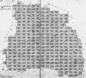
Daun heeded Lacy's appeal, and on 5 May 1764, forwarded the request for mapping operations to Maria Theresa, who approved the project. Daun proposed the completion of a uniform cartographical project of all the dynasty's dominions.Footnote 19 The survey was to serve military purposes, and this entailed secrecy. Through its richness of detail and the sheer size of the area covered, the map finished in 1787 was impressive. Twenty-one different surveys of countries and regions resulted in 3,324 sheets drawn at a 1:28,800 scale and 275 sheets drawn at a 1:11,520 scale (for the territory of Austrian Netherlands). The map of Transylvania included 280 sections (see Figure 1), each covering an area of 18 × 12 kilometers (11 × 7.5 miles).Footnote 20
The Sections of the Josephinische Aufnahme for Transylvania.Footnote 21

Because of their classified status, the representations did not exert any influence on contemporary civil cartographic projects. In addition, because astronomic measurements did not factor into the mapping process, the 3,599 sheets could not be put together to recreate a single, immense depiction of the monarchy's possessions. These maps served the Habsburg state's strategic planning until 1869, when a cartographic depiction executed on the basis of the third Austrian survey on a scale of 1:75,000 replaced it.Footnote 22 The project is remembered as the Josephinische Aufnahme because of Joseph II's contribution to it. As co-regent with his mother since 1765, he directed military matters. Joseph II's close collaboration with the Hofkriegsrat's president, Daun, and his successor, Field Marshal Lacy, led to innovations such as the use of drill and exercise manuals for the soldiers' training and also the introduction of inspectors general.Footnote 23 The cartographic initiative was part of the same package of military reforms.Footnote 24
The order in which the state mapped its territories suggests the primarily military value of the Aufnahme. Throughout the eighteenth century, Transylvania remained a frontier region, vulnerable to Tartar invasions and Ottoman attacks, and accurate mapping provided one way to successfully counter a potential raid, as it allowed the army to prepare a better defense against invasions. For example, in 1769 there was a real fear of a Tartar invasion in the principality of Transylvania. The commander Fabris of the Quartermaster General Staff (Generalquartiermeisterstabes) and a number of officers assigned to the region received orders from Vienna to start the process of mapping the Josephinische Aufnahme for this province, from the borders of Transylvania with Moldavia and Wallachia, after which they were to continue mapping the principality, from the eastern borders toward the west.Footnote 25
On 16 March 1769, Field Marshal Lacy (now president of the War Council), wrote to the general in command in Transylvania, Count O'Donnell, instructing him to carry out an “economic survey” (öconomische Conscription). In the end, four enterprises took place concurrently in Transylvania: a military survey on a scale of 1:28,800; the description of the survey sections; a survey of all the settlements; and an economic description.Footnote 26 Lacy instructed the surveyors on what elements to incorporate in the descriptions. This order reveals again the dual dimension of the map (military and economic), as the descriptions had to include:
a. the distance between the places marked on the map
b. the depth and width of the rivers, the quality of their banks, the places where the rivers could be crossed and whether they could be crossed by people, riders and/or carriages
c. the forests, the roads used to transport wood from the forest, the number of paths, various obstacles encountered in the forest (hills, valleys, swamps), details about the age of the forest, the height of the trees
d. information about the various swamps and whether the swamps could be crossed on foot, on horseback, [and] during which seasons; mention whether the swamp crossing conditions were influenced by the weather
e. details about the quality of the lakes' water, the surface the lakes could inundate during rainy seasons
f. the highest hills or mountains which could be used as observation points
g. the condition of the roads and footpaths during bad weather
h. the position of the churches, graveyards, farms, mills or other important buildings, which offered housing options for troops, and populated the landscape with noteworthy landmarks.Footnote 27
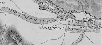
The entry in the economic description for the village Szász Fénes illustrates how all settlements' presentations followed the template suggested by Lacy.Footnote 28 The account specifies that the Szamos River, located in the north of the settlement, was 20 Schritt wide and 1½ to 2 Schuch deep, and the river bed was sandy and stony. The road from Clausenburg to Banfihunyad passed through here, and it was wide enough to allow carriage traffic in dry weather. The surrounding forests were tall, and the church located in the village was built of stone.Footnote 29 The depiction of this village on the map (see Figure 2) could not reveal all this numerical and qualitative data, which was nonetheless essential for the troops' movement through the area.Footnote 30 Therefore, for each map section, the descriptions also include general information about the terrain, under the section “Main Observations.” For section 83 of Transylvania's map, the surveyor warned the reader against marching the troops in this area during rainy weather, as the swampy ground could greatly slow down the maneuvers.Footnote 31
The village Szász Fénes, Section 82.

Although most of the historiography discussing this cartographic project stresses only its military value for the Habsburgs, I argue that the map and its attached documents, as demonstrated by the elements they collected, also served economic, social, and religious innovations.Footnote 32 The next sections analyze the role cartographic projects such as the Josephinische Aufnahme played in supporting both external and internal expansion projects.
The Military Dimension of the Josephinische Aufnahme
The institutional organization of eighteenth-century surveyor corps demonstrates that maps served primarily military interests. During Maria Theresa's reign, cartographic engineers became state employees. In 1747, the engineers' professional group became a special division subordinate to the Headquarters of the Quartermaster General, and a topographic department became part of the Military Archive, solidifying the bond between the army's interests and cartography.Footnote 33
In a letter to Maria Theresa on 3 April 1761, in which he discusses his ideas about military reform, Joseph II stressed the key role of army engineers in knowing the territory and keeping updated maps with them during military conflicts: “[A]s for the engineers, they will be distributed among all the provinces, and they will have to know the territory in which they are sent thoroughly, and to have very detailed maps not only of that territory but also of all the adjacent territories.”Footnote 34
The important part army engineers played in the survey operations is confirmed by the personnel working on the Josephinische Aufnahme. From 1769 to 1772, Colonel Fabris and his subordinate officers mapped Transylvania.Footnote 35 An order from the Kaiserlich–Königlicher Generalquartiermeisterstab (Imperial-Royal Staff of Logistics, created in 1758 and in charge of all the military surveys) from 31 January 1773 mentions Colonel Fabris's promotion to General Major.Footnote 36 Therefore, Major Jeney became the new officer in charge of finishing the mapping of Transylvania.Footnote 37 Both Fabris and Jeney also worked in other provinces on the Josephinische Aufnahme (Bohemia, the three Austrian districts of Silesia, the Croatian-Slavonian Kingdom, the Military frontier districts of Croatia-Slavonia, Inner Austria).Footnote 38
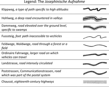
In surveying the principality, the central authorities took extensive care to record the road network. As a potential military theater, Transylvania's lines of communication had to be depicted as accurately as possible. The imperial order asked the surveyors to use at least nine types of symbols to differentiate among different qualities and types of road. This explains why the legend of the map distinguishes among the following notations (see Figure 3).Footnote 39
The Josephinische Aufnahme. Adapted from Borbély and Nagy, “Der ersten militärischen Aufnahmen.”

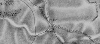
The labeling of certain roads but not others suggests the importance of the road network for the army. Only the main roads had clear identifications, because labels ensured the orientation of the troops and eased the relaying of orders. To give a concrete example, the Landstrasse, which linked Clausenburg and Maros Vásárhely, had strategic value in a potential armed confrontation; consequently the cartographer labeled it (see Figure 4).Footnote 40 By contrast, other roads and paths were not labeled.
The Landstrasse connecting Clausenburg and Maros Vásárhely, Section 85.

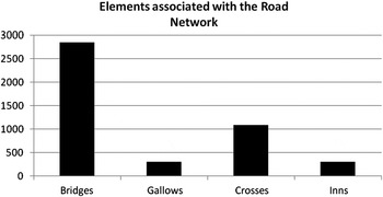
Roads are more than lines uniting destinations. There are many other elements, such as bridges, gallows, inns, and wood or stone crosses, that accompany the depiction of roads. The mapmakers included all these elements, as synthesized in Figure 5. Such attention to depicting accurately the human impact on the landscape reveals both a desire for knowing the state of the communication networks, while also paving the way for future developments.
Elements associated with the Road Network

The richness of detail characterizing the Josephinische Aufnahme served Habsburg military purposes. But moving beyond the seemingly objective depiction of the Transylvanian landscape, the map can be interpreted as a reflection of Habsburg consolidation and expansionism in the late eighteenth century. The Habsburgs' efforts to map Transylvania are part of their drive toward uniformity. Throughout the eighteenth century, the Habsburg elites strived to integrate the southern, western, and eastern border regions more fully into the monarchy. This process culminated during the reigns of Maria Theresa and Joseph II. Whereas Maria Teresa tolerated the survival of some provincial specificity, Joseph II ignored constitutional limitations on his rule in the Austrian Netherlands and even refused to be crowned king of Hungary and Bohemia. The emperor was determined to impose the principle of Gleichförmigkeit, or uniform government, in all Habsburg provinces, and he reorganized outer provinces on the model of the core Habsburg provinces.Footnote 41 The Josephinische Aufnahme can be read as a product of these imperial uniformizing goals, even before Joseph II became the sole ruler of the Habsburg lands. Additionally, the Habsburg cartographic projects are connected to numerous military conflicts in Eastern Europe, which triggered a continuous readjustment of borders.
The 1768–74 Russo-Ottoman War and Habsburg Expansionism
In the eighteenth century, the Habsburgs, the Romanovs, and the Ottomans were constantly at each other's throats, fighting for supremacy in Eastern Europe. The “Eastern Question,” which strongly impacted international relations in the nineteenth century had its origins in the repeated defeats the Ottomans suffered a century before in front of Russian and Austrian armies. Historians such as Virginia Aksan, Michael Hochedlinger, Karl Roider, and Franz Szabo discuss the multiple military challenges Vienna faced in the eighteenth century.Footnote 42 Although some scholars have focused their attention on the Christian-Muslim component of the military conflicts in Eastern and Central Europe, others have prioritized Russia's emergence as the main political actor in Eastern Europe.Footnote 43 The Habsburg policy makers hesitated throughout this period between allying themselves with Russia against the Ottomans and preserving the status quo, in order to keep a strong potential competitor (Russia) out of the Balkans. The Habsburgs had to operate both on the western front against Prussia and on an eastern front in the Balkans and Poland. Karl Roider and Virginia Aksan analyze the interdependence between these two conflict arenas and recreate the complex image of the triple Russo-Ottoman-Habsburg imperial confrontation in Eastern Europe from the Habsburg and the Ottoman point of views.Footnote 44
Joseph II's efforts to increase and strengthen the Habsburg army aimed both at territorial defense and eventual expansion. The emperor and Chancellor Kaunitz understood the impossibility of sudden territorial expansion and prioritized negotiation over warfare. However, when they felt the international situation was favorable to Habsburg expansion, the Viennese decision makers enlarged the monarchy's boundaries. The first partition of Poland (1772) and the annexation of Bukovina (1775) are cases in point. To aid in their decision making about whether to enter or stay out of conflicts, the Habsburgs used maps. In this sense, cartographical projects anticipated Habsburg expansionism. In order to understand the Habsburgs' decision to engage only in some of the wars involving the Ottomans, their access to military-sensitive information has to be reevaluated. Joseph II's effort in the midst of the 1768–1774 Russo-Ottoman war to collect cartographic information proves the maps' importance in the emperor's decision-making process. In the confrontation among Vienna, Constantinople, and St. Petersburg, the Josephinische Aufnahme, supplemented by additional mapping enterprises in the 1770s in Moldavia and Wallachia, anticipated the expansion of the monarchy to Bukovina and the preservation of the Danubian Principalities as buffer states between the Habsburgs and the Russians.
During his tour of Transylvania in 1773, Joseph II expressed his discontent with the Transylvanian parts of the Josephinische Aufnahme sections that had been produced since 1769, and he ordered the surveyors to improve the accuracy of the cartographic representation of the border between Transylvania and its neighboring provinces, Ottoman-controlled Moldavia and Wallachia (collectively known as the Danubian Principalities). He not only desired to map the frontier, but also to obtain accurate representations of part of the inner territory of Moldavia and Wallachia. The Aufnahme not only served the purpose of strengthening defense, but it also reflected the expansionist goals of the Habsburg monarchy. The Habsburgs were more than passive spectators during the 1768–1774 Russo-Ottoman war, and Joseph's 1773 tour in Transylvania, Galicia, and Bukovina paved the way for further annexations to the Habsburg realm in 1775.
From the moment Russian troops occupied Moldavia and Wallachia in 1769, Maria Theresa, Joseph II, and Kaunitz seriously considered the possibility of having to enter the Russo-Ottoman conflict on the side of the Porte.Footnote 45 Moldavia and Wallachia were vassal principalities of the Ottoman Empire, located east and south of Transylvania, respectively. The Habsburgs feared that Russia's occupation of these provinces marked the beginning of its permanent domination over the area. When in 1770 Catherine the Great demanded the right to control Moldavia and Wallachia for twenty-five years, she confirmed the monarchy's fears.Footnote 46 Chancellor Kaunitz argued strongly for declaring war on Catherine the Great and hoped that siding with the Ottomans would lead to the Habsburg monarchy's re-annexation of the western part of Wallachia. Joseph II suggested a different approach: Allow the Russian and the Ottoman forces to fight each other and only intervene in the conflict if the Russians were winning. He stressed the futility of an attack against Russia without obtaining Prussia's support, or at least its neutrality.Footnote 47 Prussia's refusal to promise neutrality prevented a Russian-Austrian military clash.Footnote 48 Chancellor Kaunitz, Joseph II, and Maria Theresa then debated their next step. Reinforcing the army in Transylvania represented the only course of action on which all three agreed. As it turned out, the demonstration of military might staged in Transylvania convinced the Russians that Habsburg interests would not easily accommodate Russian expansionism in the Danubian Principalities.Footnote 49
Joseph II had originally planned a journey to Transylvania for 1772. Because of military and political developments, however, his journey had to be postponed by a year. After the first partition of Poland and the annexation of Galicia (located in close proximity to Transylvania), Joseph II decided to inspect the newly acquired region as well. On the way to Galicia, he allocated some months for travelling around Transylvania.Footnote 50
One of Joseph's goals during his tour of Transylvania was to analyze the advantages of a potential annexation of the western part of Wallachia, which Chancellor Kaunitz favored. Writing to Maria Theresa in June 1773, the emperor noted:
after I have thoroughly examined the Rothenthurm Pass, I cannot hide from Your Majesty that the more I see this country, the more I am convinced that the acquisition of the Wallachia surnamed Austrian would bring more disadvantages than advantages to the state. … I dare to ask Your Majesty to transmit this information to prince Kaunitz, and I take the responsibility to counsel Your Majesty against the acquisition [of Little Wallachia].Footnote 51
Although Little Wallachia had been part of the Habsburg monarchy, between 1718 and 1739, Joseph II's assessment of potential re-annexation influenced the Monarchy's foreign policy with respect to the region. On 31 July 1777, in a letter to Count Mercy-Argenteau, the Habsburg ambassador to France, Maria Theresa stated: “unhealthy provinces, without culture, depopulated or inhabited by perfidious and ill-intentioned Greeks, would be more likely to exhaust than to augment the forces of the monarchy.” To Joseph II's rejection of Little Wallachia because of strategic reasons, Maria Theresa thus added a moral dimension.Footnote 52
Instead of Little Wallachia, Joseph II suggested an alternative annexation. While inspecting the territory of Galicia, the emperor discovered that the best way to connect Transylvania and eastern Galicia ran through the northern section of Ottoman Moldavia, a region soon to be named Bukovina. In a letter to his mother, Joseph II wrote that this territory would “facilitate our communications and our commerce as well as win for us the passageway for our troops in case of war from one to the other of our provinces which would otherwise have to make a terrible detour to join together.”Footnote 53 After he decided that Bukovina should be claimed from the Ottomans, in 1773, the emperor ordered Austrian officers to go to the region (still under Russian control) and start mapping it.Footnote 54 This initiative was taken two years before the Ottoman Empire accepted ceding Bukovina.
Maria Theresa and Kaunitz took Joseph II's suggestion seriously. The empress ordered J. A. Thugut, the Habsburg ambassador to Constantinople, to persuade the sultan to exchange Bukovina for help in obtaining an advantageous peace treaty with the Russians. In 1774, Thugut advised Chancellor Kaunitz to go ahead and order the occupation of Bukovina, as the new de facto situation would give Vienna the upper hand in the negotiations.Footnote 55 In 1774, as Catherine finally withdrew her troops from Bukovina and the Principalities, Maria Theresa ordered the occupation of Bukovina. Thus, the Austrians acquired 10,500 square kilometers and 70,000 inhabitants.Footnote 56 On 23 November 1774, in a dispatch addressed to his brother Leopold, Joseph wrote:
From here the most interesting news is the uncertainty in which we persist regarding our frontiers in Poland … we have advanced our borders right after the concluded peace treaty up to the forest called Bukovina…and this gives us incalculable advantages, because it opens up direct communication between Transylvania and Pocutia, gives us clear borders, forests, pastures and around thirty villages.Footnote 57
Expanding the empire by taking advantage of the Russo-Ottoman rivalry proved successful. However, at the time of Joseph II's visit to Transylvania, the war had not reached its conclusion, and there remained a chance that Austria might have to get involved in the conflict. During his three-month journey in Transylvania, the emperor thus devoted seven full days to inspecting the borders with Moldavia and Wallachia. On 5 and 6 June, he allocated nine hours a day to the examination of Transylvania's southern frontier; and on 10, 11, 13, 14, and 16 June, he devoted up to eleven hours a day to the inspection of the province's eastern frontier.Footnote 58 This first-hand experience of Transylvania's borders led Joseph to express his discontent with the latest cartographic representation of the area.
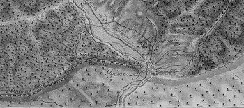
On 14 June 1773, Joseph inspected the Gymes pass, which connected Transylvania and Moldavia. The cartographic representation of this area on the Josephinische Aufnahme reveals the discrepancy between the rich details on the Transylvanian side and the scarcity of information for the region across the border (see Figure 6).Footnote 59 This is not an isolated occurrence. For the whole length of the border between the Habsburg territories and the Danubian Principalities, the cartographers lacked information about the other side of the border. No wonder that after he traveled to Transylvania and then saw the map, Joseph II complained that the main passes, roads, and footpaths were not represented accurately on the map. This faulty depiction of the border could negatively affect military operations in the area. Consequently, the emperor ordered General Barco to obtain the permission of the Russian commandant of Moldavia and Wallachia, to undertake mapping operations on the other side of the border.Footnote 60
The Gymes pass, Section 164.

A new border-survey was the result. Major Jeney and his team of surveyors finished this new project at the end of 1774. The new maps could be joined to the Transylvanian sheets of the Josephinische Aufnahme in the eastern and southern direction, providing detailed representations not only of the Transylvanian side of the border, but also part of the adjoining Danubian Principalities.Footnote 61
The cartographic initiatives of the Habsburg monarchy at the borders of the Danubian Principalities mapped lands lying outside the borders of the empire. Joseph II was directly involved in the cartographic projects of the early 1770s and considered maps both a preliminary step in a potential expansion of the empire and a necessary defense instrument. Although Vienna did not extend its direct control over all of Moldavia and Wallachia, it maintained the Danubian Principalities as buffer states between Habsburg territories and the double Russian-Ottoman menace. Furthermore, through a crafty combination of diplomatic and military pressures, Vienna obtained a part of Moldavia: Bukovina. Habsburg mapping projects in the eastern borderlands of the monarchy should be given their fair share in the narrative of the Russian-Austrian-Ottoman military confrontations in the second half of the eighteenth century.
The Economic Dimension of the Josephinische Aufnahme
The Josephinische Aufnahme served not only the army's interests, but it also constituted an essential component of economic measures, such as the ones related to the development of the mining industry and population management. From the Aufnahme's early phases, Maria Theresa and Joseph II valued the maps as government tools that could serve to improve the state's finances and to stimulate the economy.Footnote 62 Indeed, the mapping of new territories usually accompanied early-modern imperial projects. Studies of British, French, Russian, Portuguese, and Spanish imperial enterprises analyze the relationship between the management of the territories by the central power and the projects of territorial and economic representation. The Habsburg imperial project enacted in Transylvania is part of a larger process of centralization unfolding all over the monarchy, including its heartlands. However, as a result of its peripheral geographical position with respect to Vienna, Transylvania represented more of an unknown land than did older Habsburg possessions. Moreover, this province represented both a potential gate for foreign invasion and also a potential bridge for further expansion of the Habsburg borders.
Alex Drace-Francis argues that the Habsburgs' integration of their southeastern frontier may be compared with other contemporary imperial enterprises. An imperial aspect Drace-Francis identifies, but does not explore further, regards Vienna's exploitation of provincial resources.Footnote 63 The Josephinische Aufnahme also had a pronounced economic dimension in relationship to the province of Transylvania, especially with respect to the exploitation of mines and the management of the population. This aspect of the Habsburg cartographic enterprise can be better explored through an examination of the other major enterprise that took place concurrently with the mapping of the province: the detailed economic description of all of Transylvania's settlements and their surroundings.
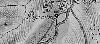
The economic survey of the Transylvanian Principality followed a very strict template. In 1769, the President of the War Council, Field Marshal Lacy, sent a comprehensive list of objectives that the economic description had to contain for each settlement: an assessment of the land quality (arable, fallow, sandy); mentions of meadows, vineyards, woods, marshes, lakes, mills, important crops; the inhabitants' professions; existing manufactures or factories; and natural resources.Footnote 64 Based on the Josephinische Aufnahme, information about economic objectives, such as mills, can be synthesized. Figure 7 reproduces the depiction of a paper mill, situated in the proximity of the village Sebes Varalya.Footnote 65 This example is only one of hundreds of mills recorded on the map by the surveyors. The different types of mills—water mills, sawmills, stamp mills, paper mills, windmills—served specific economic activities. For example, stamp mills processed mineral resources, such as gold and silver.
Paper mill next to the village Sebes Varalya, Section 59.

Mining for Revenue
Eighteenth-century cameralists posited that the power of territorial rulers rested on economic prosperity, and the three main sources of wealth were the Crown's domains, various royal duties and levies, and the taxes negotiated with the Estates.Footnote 66 Although the Estates repeatedly refused to cooperate with Vienna, the monarchy had relatively more control over the “cameral” revenue derived from royal domains, mines, salt, customs, and excise.Footnote 67 Andre Wakefield demonstrates the intimate connection between cameral sciences and the sciences of nature, especially chemistry and mineralogy.Footnote 68 Johann Heinrich Gottlob von Justi, Christoph Traugott Delius, Joseph von Sonnenfels, and Ignaz von Born were just some of the top-level Habsburg bureaucrats and advisers who promoted the exploitation of natural resources as the backbone of the state's revenue. As Justi stated, the purpose of mining was to “increase the treasure of the country with respect to the amount of gold and silver which they extract from the earth.”Footnote 69
The interest of the imperial court in Transylvania's natural resources increased throughout the eighteenth century, especially after the loss of most of Silesia, rich in mineral deposits, to Prussia. Mining represented the most valuable economic activity for the Habsburg monarchy, and the state had the legal right to control it through state works or leaseholders. The Hofkammer controlled the mining institutions since the beginning of the eighteenth century, and in 1746 Maria Theresa created a special office, Bergkollegium, which was in charge of the Mint and mines.Footnote 70 The salt from Transylvania and the Hungarian county of Maramaros represented the main source of salt for Hungary, Banat, Croatia, Slavonia, Serbia, Moravia, and Silesia, and the Habsburg state held a monopoly on salt exploitation and commercialization.Footnote 71 After the Seven Years' War, Maria Theresa decided to increase the monopoly price of government salt in all lands by one florin per centner in order to obtain new funds to pay the interest on the high governmental debts, thus demonstrating her understanding of the capacity of salt commercialization to save the empire from financial difficulties.Footnote 72
Maria Theresa also reformed the university system to train better imperial mining administrators. In 1763, she reorganized the mining school in Schemnitz, one of the centers of precious metal production, into an imperial mining academy. Based on the recommendations of Christoph Traugott Delius, the empress established chairs of mineralogy, chemistry, and metallurgy.Footnote 73 Delius offered lectures on forestry, because, as Maria Theresa emphasized, this “is essential for mining,” impacting the safety of mines, the mineral production, and the smelting of metal.Footnote 74
Gaining control of the salt and gold mines in Transylvania represented one of Vienna's main objectives after conquering the Principality in 1699. Maria Theresa was one of the main shareholders of the Transylvanian gold and silver mining enterprises, and as a result of her and Joseph II's efforts, between the early 1720s and 1770 gold production tripled. By the first half of the nineteenth century, Transylvania produced more gold than all other parts of Europe combined. Therefore, although gold, copper, and silver mines were not Treasury monopolies, the Habsburg rulers still used them to increase the monarchy's revenue.Footnote 75
The salt mines in Transylvania rivaled the famous deposits of Wieliczka and Bochnia in Galicia, and the Habsburgs brought in experienced miners from Tirol and Bohemia to increase production.Footnote 76 Acknowledging the importance of salt resources, in 1699, the Hofkammer (the Viennese institution in charge of mines' administration) sent a special commission led by Baron Ludwig Albrecht von Tavonath to inquire into the causes of huge quantities of salt losses. The salt obtained from Transylvanian mines often did not reach the imperial storage centers because of the poor transport organization on the Maros River and to contraband activities. Based on the report of the Tavonath commission sent to assess the mining industry's situation and to suggest how to reorganize the exploitation, transport, and commercialization of salt, on 15 January 1700, the Hofkammer in Vienna sent a detailed list of recommendations to improve the profitability of the Transylvania salt mines to the provincial administration. The Hofkammer identified the free access that nobles, the church, and other special groups had to the mines as one of the main problems. The Hofkammer also recommended special measures to improve the quality of the water transport on the Maros, and it interdicted salt import from Wallachia and Moldavia.Footnote 77
During the mapping of Transylvania, an important imperial employee visited the region. Ignaz von Born, one of the best European mineralogists serving the Habsburgs requested a leave to visit the goldmine located in Transylvania at Nagyag and to take care of some family issues.Footnote 78 Von Born was originally from Transylvania, and he had successfully reached the top tier of the Mining Administration hierarchy in Bohemia. Born's book, Briefe über mineralogische Gegenstände, auf seiner Reise durch das Temeswarer Bannat, Siebenbürgen, Ober- und Nieder-Hungarn geschrieben, first published in Leipzig in 1774, and then translated into English, Italian, and French, represents an invaluable source about mineral deposits in Transylvania. Drace-Francis suggests that there was a correlation between von Born's journey in 1770 and Joseph II's travels in Banat and Transylvania in 1773, as the information gathered by von Born could have been considered sensitive strategic knowledge.Footnote 79 Furthermore, in 1770, von Born became the Assessor of the Bohemian Mining and Minting Directorate in Prague. This confirms his role as a key Habsburg advisor on mining. The representation of mines on the Josephinische Aufnahme, the journal Joseph II kept during his trip to Transylvania, and the report he filed at the end of this journey all suggest that von Born's survey of mines in Hungary, Banat, and Transylvania helped the imperial court make better use of the mineral resources from these provinces. Von Born included part of his itinerary through Transylvania in his own published work, revealing the various stops and inspections he made at mining sites.
In 1773, Joseph II's route allowed him to stop at various salt, gold, and iron mines, and he provided commentaries on all these visits in his journal. The emperor had meetings with the main functionaries in charge of mines and salt deposits; and in the final report to Maria Theresa he stated, “I have inquired closely about all the salt-transportation routes, and I could write a very detailed description of it.”Footnote 80 Based on Joseph II's travel notes, it seems that before entering Transylvania, the emperor stopped at Szegedin, in Hungary. Here, he met with salt-bailiff Gruber. Joseph recorded in his journal that Gruber made no promises about gathering all the salt quantity (800,000 quintals) necessary for Szegedin and for three other [?] cities for this year, because he had been promised only 600,000 quintals from Transylvania.Footnote 81 Furthermore, the arrival of this quantity depended on whether the salt would travel safely on the Maros River. Joseph concluded that the lack of ships and personnel to navigate the river hindered the transport of salt.Footnote 82
The emperor made good use of the information obtained from Gruber. Later in his journey, he visited Carlsburg's (Alba-Iulia) salt deposit, in Transylvania. In Carlsburg, Joseph II inquired about the organization of the salt transport, and Salt Director Kern offered him detailed information, carefully recorded in the emperor's journal. Kern and Joseph II even calculated the number of ships and men needed to transport the salt to Szegedin. Kern also complained to the emperor that Vienna's desire for full control of the salt administration slowed down the decision-making process, as every local decision had to be approved in Vienna. The lack of local autonomy regarding decisions about mining proves the high importance the revenue obtained from these enterprises had for the Crown.
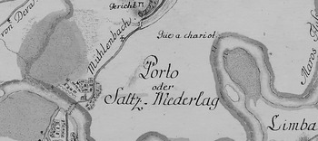
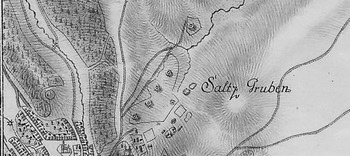
The Habsburg monarchy's preoccupation with salt exploitation in Transylvania impacted the mapping of the province. The surveyors marked with special drawings and key words all mining-related sites. For example, the salt deposit (Saltz-Niederlag) Joseph II inquired about on 27 June 1773 is marked as located right next to Carlsburg, on the Maros River (see Figure 8).Footnote 83
The salt deposit next to Carlsburg, Section 170.

In Torda, another important salt basin (Figure 9), Joseph II visited “the five salt-mines, the deepest of which has about 60 Klafter [fathoms],” and commented that “the system of extraction is similar to the other salt-mines, the deposits are very full, and the salt production shows no deficiencies.”Footnote 84 All in all, the emperor was content with the situation at Torda and after his talk with the main salt administrator, Joseph Hodor, Joseph II appreciated him for being very well informed and competent.
The Torda salt mines, Section 110.

Von Born had also visited the salt mines in Torda on his trip three years before Joseph II made his trip. The mineralogist had descended into the mines Theresa and Coloser, the second being “sixty fathoms depth, and fifty fathoms diameter.”Footnote 85 In his letter of 28 July 1770, he commented extensively on the inefficient use of small blocks of salt:
After having satisfied my curiosity under ground, I saw the immense piles of rejected salt-rocks which are under the prescribed size. They are kept for no use; and severe penal laws forbid even the poor to make use of them. The reasons which they gave me for this unaccountable squandering away of so useful a substance, were as follows: That to prevent smuggling pieces of the same weight were given to the carriers, and that the abundance of the Transsylvania salt-mines did not seem to require any grudging, or fending the smaller salt-pieces in sacks or casks. This might do, if the world was only to last but a thousand years more; but good public economy takes care of the latest prosperity and disapproves any arbitrary and unnecessary destruction of an useful mineral as inhuman extravagance. Many hundred millions weight of rejected salt are thus exposed to dissolving rain and snows—and what vast quantities are spent in a similar way near and in the Vizakna, Koloser, Szekes, Deese and Paraite salt-mines?Footnote 86
Joseph II confirmed Ignaz von Born's comment about the quantity of wasted salt. The emperor noted in his final report that “the salt mines are a great blessing, which brings several million a year, and whose richness and productivity is so large, that their exploitation is treated in a wasteful way; the profit could be multiplied by six, if only some of the salt would not be thrown away.”Footnote 87
As reflected in their testimonies, both Joseph II and Ignaz von Born gave serious consideration to minimizing the waste of salt. Curtailing the right of the clergy and free supplies of salt was one way in which the Habsburg authorities increased the profit obtained from the mines. By the end of Maria Theresa's reign, salt represented the source of 61 percent of the total revenue managed by the Hungarian Royal Chamber, which also included the profits obtained from Transylvanian salt. Joseph II continued the effort to boost salt production. In 1784, he issued a regulation that exempted serfs involved in transporting salt from labor dues to the nobles.Footnote 88
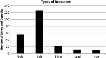
Joseph II's journal, Ignaz von Born's published work, and the imperial measures issued to protect and increase the Habsburg revenue obtained from mining, can be correlated with the graphic representation of the Transylvanian mineral resources. Figure 10 shows the total number of mines and deposits marked on the Josephinische Aufnahme and confirms the importance of Transylvania as a gold, salt, and silver provider for the empire.
Types of resources.

Where There Are People, There Is Wealth
From the seventeenth century onward, cameralist writings addressed the issue of population as a key state resource. Johann von Justi exclaimed that “a country in which subsistence and commerce flourish can never have too many inhabitants,” and Joseph von Sonnenfels argued that increasing the size of the population should be one of the basic principles of a state's economy.Footnote 89 The writings of these two cameralists were influential during the reign of Maria Theresa, as attested by Justi's and Sonnenfels's appointments in the 1760s to professorships of Cameral Sciences at the University of Vienna.Footnote 90 Their populationist theories convinced Maria Theresa that freeing the peasantry would help increase the population and the monarchy's wealth. Therefore, the empress abolished large-scale serf-based farming on the Crown's lands, abolished the labor dues, and raised taxes in the form of rental fees paid by peasants for the use of the land.Footnote 91
The emigration produced by oppressive institutions of serfdom represented a grave concern for Vienna. Transylvanian peasants frequently crossed the Carpathians into Moldavia and Wallachia to escape serfdom. In June 1770, rumors about the serfs' emancipation in Moldavia caused fears in Vienna of an exodus of the Transylvanian peasants across the border.Footnote 92 During his journey to Transylvania, Joseph II investigated the emigration issue firsthand. In his final report, he noted that people “are leaving together with many cattle, goods, women, children and horses. The indifference with which the emigration is looked upon here, confirms my suspicions, that the landowners are causing the misery of the subjects.”Footnote 93 Joseph II agreed with Maria Theresa that the landowners' abuses and the institution of serfdom not only caused grievances for the local population, but also negatively affected the revenue raised by the Habsburg authorities from the province. In a memorandum from 1765, Joseph II stated: “I consider the principal aim, in accordance with which not only the government in general but also the financial and military administrations ought to regulate their actions, to be population, that is the conservation and the augmentation of [the number of] subjects.”Footnote 94
In order to encourage a systematic increase in population, the government needed at least a rough estimate of the number of its inhabitants. The Josephinische Aufnahme served this function roughly until 1785 when a more systematic demographic survey was accomplished. Although neither the map nor the economic description contains population estimates for the various settlements, other elements compensated for the missing information. For each town and village, the surveyors sketched the topography of the settlement, marking the location and orientation of all buildings, such as churches, barns, mills, inns, and particularly important, households.
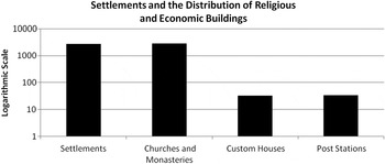
Each section of the map records in the right corner the names of the settlements depicted wholly or partially in that particular section. The total number of settlements for Transylvania marked on the map is 2,727. The cartographers included on the map various elements primarily associated with settlements, such as churches, postal stations, and customs offices. Figure 11 shows the distribution of these buildings with respect to the number of settlements.
Settlements and the distribution of religious and economic buildings

It is widely accepted that Joseph II ordered the first demographic survey of Transylvania in 1785, following up on the work of the Josephinische Aufnahme. A letter sent by Joseph II to Chancellor Eszterházy in 1784 reveals the main factors that motivated this measure: the need to reorganize conscription and taxation on more solid bases.Footnote 95 Indeed, the 1750 conscription of Transylvania had targeted only tax-paying families and their goods.Footnote 96 The privileged groups, such as the nobles and the clergy belonging to the Catholic, Lutheran, Calvinist, or Unitarian confessions had remained outside the scope of this Habsburg enterprise.Footnote 97 Moreover, the written descriptions of the 2,001 settlements had no visual equivalent in the form of maps. However, from 1769 to 1773, the Habsburg authorities had counted, organized, and made a comprehensive inventory of Transylvania's potential contribution to the state in both a written and a visual form. These actions, part of the Josephinische Aufnahme, represented a preliminary measure toward assessing the whole population of the province and preparing the tax reforms. Furthermore, the military personnel involved in the later 1785 demographic survey and the land cadastre developed the necessary skills during their work on the Aufnahme. Colonel von Neu had been directly involved in the 1769–1773 mapping process and later supervised the land cadastre in Hungary and Transylvania.Footnote 98
Conclusion
An analysis of the Transylvanian section of the Josephinische Aufnahme confirms the importance of cartographic sources for understanding Habsburg Enlightened Absolutism. The attention to military and economic details and the various taxonomies developed for enumerating roads, mills, mines, and settlements allow for the integration of this map to other eighteenth-century Enlightenment programs. The Josephinische Aufnahme reflects perfectly the interconnectedness between military and economic reforms implemented during Maria Theresa's and Joseph II's reigns. A good knowledge of the Transylvanian road network served both the army and trade; representing all the houses in each settlement helped both with the army's housing needs and with an assessment of the demographic capacities of Transylvania.
The mapping of Transylvania was part of a larger effort: representing all the possessions of the Habsburg monarchy in the same scale and with the same amount of detail. The Habsburgs' desire to obtain a to-scale map of their territories and borders can be understood as part of a worldwide effort of both European and Asian imperial powers to learn more about their possessions or to claim new territories.Footnote 99 The international competition for territory also explains why access to the Habsburg map and the rich information it contains remained limited to the reform makers in Vienna and why only three copies were made and preserved in the Imperial Archives.Footnote 100 The Josephinische Aufnahme is an imperial map because of its intended purpose and audience and because of the ways that it reflected Habsburg imperial ideology in the eighteenth century. The imperial project aimed to integrate and understand all the monarchy's provinces in order to transform unknown land into territory that was made manageable and thus ready for reform.
The ability of the central government to breach the power of the local Estates proved essential for Habsburg Enlightened Absolutism. However, the Habsburgs had to fill in all the cartographic blanks before their attempts at centralization could be effective. Only after surveying in detail, synthesizing, and reducing to graphical representations or verbal descriptions the complexity of real territories, could the Habsburgs plan their eighteenth-century defense, expansion, and reform strategies. In the process of state building and state centralization, Vienna promoted the expansion of governmental power over its own subjects and territory by first learning more about the monarchy's population and dominions. The importance of mapping for both defending the monarchy and assessing the economic potential of the various provinces was indispensable.