INTRODUCTION
Palaeodune fields comprised of unconsolidated carbonate aeolianites seem to be highly suitable for reconstructing palaeoenvironmental conditions because of their direct linkage to global sea-level change. Studies of the Bahamas (Ball, Reference Ball1967; White and Curran, Reference White and Curran1988), Australia (Ward et al., Reference Ward, Little and Thompson1979; Warren, Reference Warren1983; James and Bone, Reference James and Bone2017), Mexico (Inman, et al., Reference Inman, Ewing and Corliss1966; Fryberger et al., Reference Fryberger, Krystinik and Schenk1990) or Sri Lanka (Singhvi et al., Reference Singhvi, Deraniyagala and Sengupta1986) show the capability and the persistent interest in these lower-latitude systems located close to the coast. Different generations of carbonate aeolianites are often separated by palaeosols, as discussed, for instance, by Williamson and Yaalon (Reference Williamson and Yaalon1977), who worked in the eastern Mediterranean, or by Kruse and Meyer (Reference Kruse and Meyer1970), who studied Moroccan dune fields.
Fuerteventura possesses a long history of studies focusing on volcanic origin (Rothe, Reference Rothe1966; Fúster et al., Reference Fúster, Cendrero, Gastesi, Ibarrola and López Ruiz1968; Ibarrola, Reference Ibarrola1969; Abdel-Monem et al., Reference Abdel-Monem, Watkins and Gast1971; Casquet et al., 1980; Coello et al., Reference Coello, Cantagrel, Hernan, Foster, Ibarrola, Ancochea, Casquet, Jamond, Diaz De Teran and Cendrero1992; Muñoz et al., Reference Muñoz, Sagredo, de Ignacio, Fernández-Suárez and Jeffries2005; Troll and Carracedo, Reference Troll and Carracedo2016), but the island has also been of interest due to carbonate aeolianites (Müller, 1965; Müller and Tietz, 1975; Coudé-Gaussen et al., Reference Coudé-Gaussen, Rognon, Bergametti, Gomes, Strauss, Gros and Le Coustumer1987; Coudé-Gaussen and Rognon, Reference Coudé-Gaussen and Rognon1988; Criado et al., Reference Criado, Guillo, Hansen, Hansen, Lillo, Torres and Naranjo2004; Ortiz et al., Reference Ortiz, Torres, Yanes, Castillo, De La Nuez, Ibáñez and Alonso2005; Alcántara-Carrió et al., 2010; Alonso et al., Reference Alonso, Hernández, Alcántara-Carrió, Cabrera and Yanes2011; Faust et al., Reference Faust, Yurena, Willkommen, Roettig, Richter, Richter, Suchodoletz and Zöller2015; Roettig et al., Reference Roettig, Kolb, Wolf, Baumgart, Richter, Schleicher, Zöller and Faust2017). More recently, several studies (Criado and Dorta, Reference Criado and Dorta2003; Menéndez et al., Reference Menéndez, Díaz-Hernández, Mangas, Alonso and Sánchez-Soto2007, Reference Menéndez, Pérez-Chacón, Mangas, Tauler, Engelbrecht, Derbyshire, Cana and Alonso2013; López-García et al., 2013; von Suchodoletz et al., Reference Von Suchodoletz, Glaser, Thrippleton, Broder, Zang, Eigenmann, Kopp, Reichert and Zöller2013; Huerta et al., Reference Huerta, Rodríguez-Berriguete, Martín-García, Martín-Pérez, La Iglesia Fernández and Alonso-Zarza2015) have focused on the accumulation of African dust material preserved on these aeolianites sections. Thereby, the Canary Islands are an ideal setting to study temporal variations of dust accumulation because of their close position to the Sahara, which encompasses some of the largest dust sources at global scale (most prominent is the Bodelé Depression; Scheuvens et al., Reference Scheuvens, Schütz, Kandler, Ebert and Weinbruch2013).
So far, studies explaining mechanisms of dune formation and especially the formation of intercalated palaeosurfaces on Fuerteventura (Coudé-Gaussen and Rognon, Reference Coudé-Gaussen and Rognon1988; Criado et al. Reference Criado, Guillo, Hansen, Hansen, Lillo, Torres and Naranjo2004, Reference Criado, Yanes, Hernández and Alonso2011, Reference Criado, Torres, Hansen, Lillo and Naranjo2012; Meco et al., Reference Meco, Muhs, Fontugne, Ramos, Lomoschitz and Patterson2011) have not considered all of the three main stages: (1) dune formation, (2) dust imprint, and (3) soil-forming processes. The present study aims to contribute to the understanding of the evolution of coastal dune systems in the Canary Island, and other comparable low-latitude regions. Four main questions are addressed in the present study:
(1) What soil-forming processes can potentially take place in a subtropical environment primarily consisting of carbonate sands?
(2) What measurable physical and chemical features documented on palaeosurfaces reflect dust imprint rather than soil formation?
(3) Is it possible to distinguish among periods of soil formation, dust imprint and supply, and accumulation of carbonate sands?
(4) What do features of palaeosurfaces in dune fields on Fuerteventura tell us about the processes responsible for creating these characteristics?
To assess these questions, the present research integrates published and new field stratigraphy combined with data on physical and chemical properties extracted from several Pleistocene dune-palaeosol sequences on Fuerteventura.
GEOGRAPHICAL AND ENVIRONMENTAL SETTING
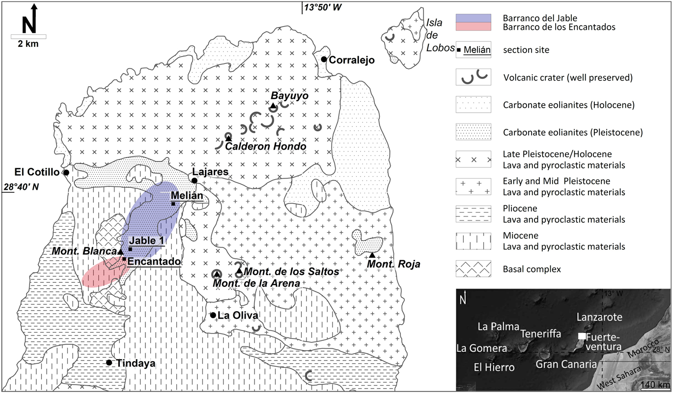
Nowadays, Fuerteventura is characterised by an annual precipitation of 147 mm (Edwards and Meco, Reference Edwards and Meco2000). The arid conditions on the island result from the influence of the trade winds in combination with reduced topography. The highest mountain on Fuerteventura is the Pico de la Zarza (~800 m above mean sea level). Different periods of volcanism are decisive for the geological structure of the island (Fig. 1). Remnants of the Cretaceous submarine “Basal Complex” is exposed in the center and the northwestern part of Fuerteventura (Coello et al., Reference Coello, Cantagrel, Hernan, Foster, Ibarrola, Ancochea, Casquet, Jamond, Diaz De Teran and Cendrero1992). Close to the western coast, ultra alkalines of Oligocene age and remains of Miocene volcanism are preserved (Muñoz et al., Reference Muñoz, Sagredo, de Ignacio, Fernández-Suárez and Jeffries2005). On the eastern coast, the Montaña Roja (~1.7 Ma) represents the middle Pleistocene period of volcanism (Criado et al., Reference Criado, Guillo, Hansen, Hansen, Lillo, Torres and Naranjo2004). Several cones and lava flows depict significant Late Pleistocene volcanism, dominating the morphology of the northern part of the island. Prominent examples related to this period are Montaña de los Saltos or the chain of volcanoes of Calderon Hondo and Bayuyo (Rothe, Reference Rothe1996; Meco et al., Reference Meco, Guillou, Carracedo, Lomoschitz, Ramos and Rodríguez-Yánez2002). Montaña de la Arena was first interpreted as a ~185-ka old volcano (Edwards and Meco, Reference Edwards and Meco2000), but later work concluded that this volcano is Holocene in age, thus representing the youngest volcanic activity on the island (Rando et al. , Reference Rando, Alcover, Navarro, García-Talavera, Hutterer and Michaux2008; Criado and Naranjo, Reference Criado and Naranjo2011). Several Pleistocene dunes and sand sheets (e.g., south of Lajares) and dunes of Holocene age (e.g., dune field of Corralejo) cover the rough volcanic landscape of Fuerteventura. The dune sediments consist of middle to coarse sand-grained unconsolidated carbonate aeolianites from the shallow shelf (Criado et al., Reference Criado, Torres, Hansen, Lillo and Naranjo2012; Roettig et al., Reference Roettig, Kolb, Wolf, Baumgart, Richter, Schleicher, Zöller and Faust2017). Up to 80% of these sediments are biogenic carbonates (Meco et al., Reference Meco, Muhs, Fontugne, Ramos, Lomoschitz and Patterson2011) containing both aragonite and calcite minerals (Coudé-Gaussen and Rognon, Reference Coudé-Gaussen and Rognon1988).
(colour online) Main geological units of northern Fuerteventura and location of sites (adapted from Rothe, Reference Rothe1996 in Roettig et al., Reference Roettig, Kolb, Wolf, Baumgart, Richter, Schleicher, Zöller and Faust2017, modified).

Studies by Coudé-Gaussen et al. (Reference Coudé-Gaussen, Rognon, Bergametti, Gomes, Strauss, Gros and Le Coustumer1987), Edwards and Meco (Reference Edwards and Meco2000), Criado and Dorta (Reference Criado and Dorta2003), and Menéndez et al. (Reference Menéndez, Díaz-Hernández, Mangas, Alonso and Sánchez-Soto2007, Reference Menéndez, Cabrera, Sánchez-Pérez, Mangas and Alonso2009, Reference Menéndez, Pérez-Chacón, Mangas, Tauler, Engelbrecht, Derbyshire, Cana and Alonso2013) pointed out the accumulation of aeolian dust as a persistent process on the Canary Islands. The silty material is mainly Saharan in origin and consists of up to 40% CaCO3 (Criado and Dorta, Reference Criado and Dorta2003; Menéndez et al., Reference Menéndez, Díaz-Hernández, Mangas, Alonso and Sánchez-Soto2007; von Suchodoletz et al., 2009) and contains significant amounts of quartz and feldspars. Quartz minerals are only found in the submarine “Basal Complex” in the eastern Canary Islands and feldspars are also rare on the island. Accordingly, quartz is an established indicator of Saharan-dust imprint in the eastern Canary Islands (Misota and Matsuhisa, Reference Misota and Matsuhisa1995; Alcántara-Carió et al., Reference Alcántara-Carió, Fernández-Bastero and Alonso2010; von Suchodoletz et al., Reference Von Suchodoletz, Glaser, Thrippleton, Broder, Zang, Eigenmann, Kopp, Reichert and Zöller2013). On Lanzarote, von Suchodoletz et al. (Reference Von Suchodoletz, Oberhänsli, Hambach, Zöller, Fuchs and Faust2010) showed the imprint of Saharan dust in valley floor sediments alternating with loess-like deposits. Regarding the Corralejo dune field, on the northeastern coast of Fuerteventura (Fig. 1), Criado et al. (Reference Criado, Torres, Hansen, Lillo and Naranjo2012) described sequences of alternating carbonate sand layers and dust deposits. Regarding soil-forming processes on Fuerteventura, so far Pomel et al. (Reference Pomel, Miallier, Fain and Sanzelle1985) have studied Late Pleistocene Rhodoxeralfs near Pajara (c.f. Fig. 9) and Faust et al. (Reference Faust, Yurena, Willkommen, Roettig, Richter, Richter, Suchodoletz and Zöller2015) have described Holocene aridisols and entisols of dune fields in northern Fuerteventura.
To summarize, palaeodune fields in northern Fuerteventura are composed of three main different parent materials: (1) carbonate sands of shelf origin (“carbonate aeolianites” [Brooke et al., 2001, p. 135.] or “unconsolidated carbonate dune sands” [Pye and Tsoar, Reference Pye and Tsoar2009, p. 362]); (2) dust of Saharan origin; and (3) material of volcanic origin (Lapilli, Tephra; Coudé-Gaussen and Rognon, Reference Coudé-Gaussen and Rognon1988; Meco et al., Reference Meco, Muhs, Fontugne, Ramos, Lomoschitz and Patterson2011; Roettig et al., Reference Roettig, Kolb, Wolf, Baumgart, Richter, Schleicher, Zöller and Faust2017) as admixture in some stratigraphic positions.
Study area
The present study focuses on three different sections that are located in the Barranco del Jable and Barranco de los Encantados (northern Fuerteventura). Barranco del Jable is a south-north-oriented Wadi system, south of the village of Lajares (Fig. 1 and 8). The upper reaches of this system are incised by gullies of up to 10 m in depth.
Barranco de los Encantados (Fig. 1 and 8) is situated in the south next to the Barranco del Jable catchment. The lower reaches of this barranco are free of sedimentary archives, whereas the middle reaches present remnants of huge accumulations of carbonate sands. The upper reaches are characterised by a gully system deeply incised into these carbonate sands (Fig. 2). Currently, it is an active system of ongoing incision. The depth of incision reaches up to 30 m. The watershed between Barranco de los Encantados and Barranco del Jable runs from the Montaña Blanca in an easterly direction (Fig. 1). Finally, both catchments belong to the same palaeodune field, which is captured by two fluvial systems from a northerly direction by Barranco del Jable and a southern to southwestern direction by Barranco de los Encantados).
(colour online) Barranco de los Encantados, view to the southwest.

The Encantado section (28.63915°N, 13.978792°W) is situated in the upper reaches of Barranco de los Encantados on the southeastern flank of the Montaña Blanca. The Melián section (28.669258°N, 13.953765°W) is located in the lower reaches of Barranco del Jable, close to the village of Lajares. Naturally, remnants of gullies are observable only on the upper slope position, right at the back of the site in an eastern direction. Nowadays low Nebkha dunes cover the surrounding surface. The El Jable section (28.643783°N, 13.974378°W) is situated in the upper reaches of Barranco del Jable. The gullies here are not as deep (roughly 10 m), but are therefore wider than the gullies of Barranco de los Encantados. So far, Roettig et al. (Reference Roettig, Kolb, Wolf, Baumgart, Richter, Schleicher, Zöller and Faust2017) presented the oldest age of 366.3±34.2 ka for the Encantado section and the youngest age of 14.9±1.2 ka for the Melián section.
METHODS
The Encantado and Jable 1 sections presented in this study are already described in detail by Roettig et al. (Reference Roettig, Kolb, Wolf, Baumgart, Richter, Schleicher, Zöller and Faust2017). The Melián section was reported by Edwards and Meco (Reference Edwards and Meco2000), Faust et al. (Reference Faust, Yurena, Willkommen, Roettig, Richter, Richter, Suchodoletz and Zöller2015), and Roettig et al. (Reference Roettig, Kolb, Wolf, Baumgart, Richter, Schleicher, Zöller and Faust2017). This study extends former results (section-wise grain size medians and elemental composition of clay fraction) and adds new data (quartz contents, micromorphological analyses, and x-ray diffraction [XRD]).
Fieldwork
The three sections Encantado, Melián, and Jable 1 (Fig. 1) were selected for sampling with regard to micromorphological analyses, XRD measurements, and determination of quartz and iron content. The profiles were studied and described based on features of palaeosurfaces and respective sediment composition of parent material, features of relocation, and mineralogical composition.
colours
colours were determined by using the Munsell (1975) scale. The colour of each sample was identified in wet conditions.
Determination of quartz contents
Automated static image analysis procedure
Granulometric and chemical analysis data were obtained from automatic static image analysis with a Malvern Morphologi G3-ID at the Geographical Institute of Research Centre for Astronomy and Earth Sciences, Hungarian Academy of Sciences. Seven mm3 of sedimentary particles were dispersed with an instantaneous, 10 ms pulse of 4 bar compressed air with a 60 s settling time onto a flat glass. Size and shape data of ~50,000 individual particles were automatically recorded for each sample from the captured high-resolution images. At the same time, the mean light intensity measured after transmission through each particle was automatically recorded by the system as a proxy of optical properties of the material, thus providing further information. Mean intensity values are dependent on chemical composition and/or thickness of the particles, while standard deviations of intensities are linked to heterogeneity of particle constitution and surface morphology.
Image analysis-based measurements were organised into a number-based database. All of the particles have their own identity number (ID), which is the primary key in the data matrix. A large number of measured particles ensures a statistically robust and objective insight into the granulometric characteristics of the investigated samples. For grain size distribution, the individual circle-equivalent diameter data were classified into grain size bins.
Chemical analysis was performed by using the Raman spectrometer of the Malvern Morphologi G3-ID. Spectra were acquired from several hundreds of targeted individual particles. These were compared with library spectra, and correlation calculations were performed to determine the chemical nature of the targeted sedimentary grains. The overwhelming majority of particles were classified as quartz particles and carbonates.
Curve fitting
The polymodal grain-size distribution curves acquired by image analysis were mathematically partitioned by applying the parametric curve fitting method. The measured curves were approximated by the summary of three, three-parameter Weibull functions by using an iterative numerical method as a least-square problem to assess the appropriate goodness of fit of measured data and calculated size distributions of mathematically constructed subpopulations. According to our assumption, the finest (W1) subpopulation can be regarded as the product of accumulation of far-travelled Saharan dust material subpopulations (for further details, see Supplementary Material).
Identification of quartz particles
Besides the relatively time-consuming Raman spectroscopy measurements, the acquired intensity values of image analysis procedure were also used. We found that the quartz particles are lighter in comparison to carbonates. Based on these findings, it was possible to determine the volumetric amount of possible quartz particles.
Micromorphological analyses
Micromorphological analyses were performed on 22 thin sections (10 from the Encantado section and 12 from the Melián section). The locations of thin sections are marked in Figures 3 and 4. We used Viscovoss N 55 S for preparation in combination with Araldite 2020. All thin sections were described following Stoops (Reference Stoops2003) using a Leica DMLP and Kappa Zelos-655C camera.
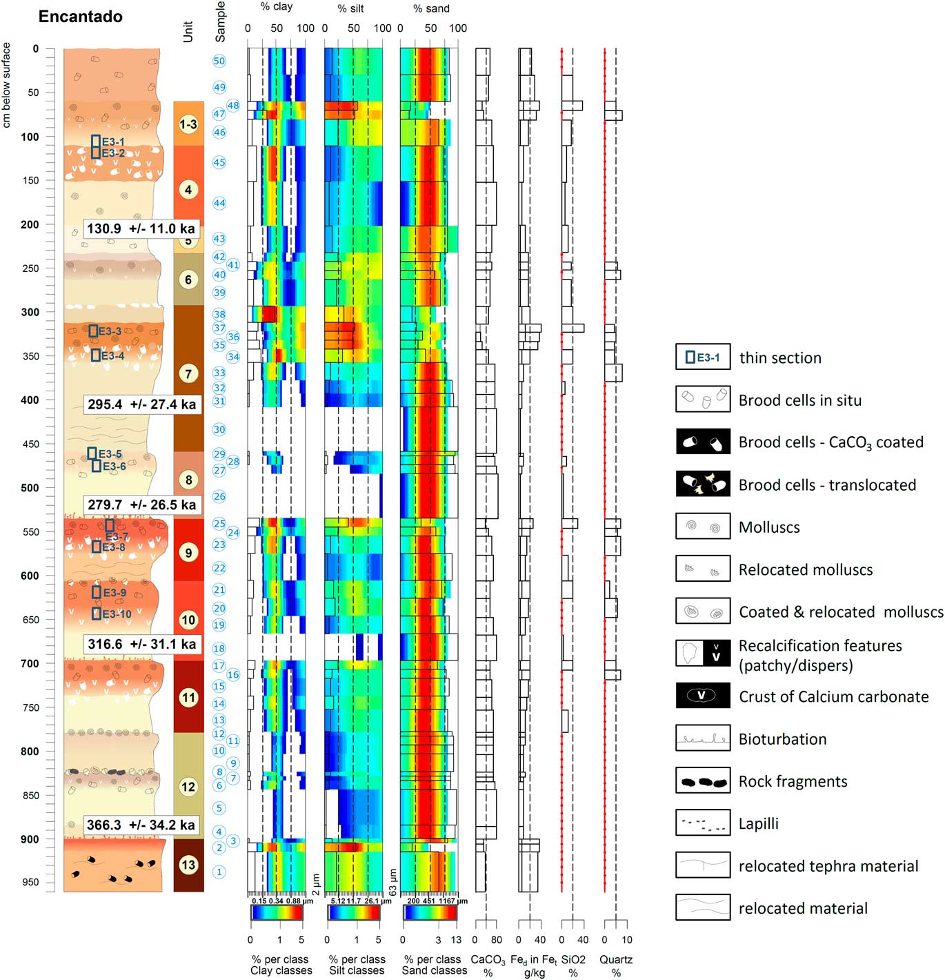
Encantado section with key including analytical data sample-wise. Sequences with no available data indicated by red lines (according to Roettig et al., Reference Roettig, Kolb, Wolf, Baumgart, Richter, Schleicher, Zöller and Faust2017, modified). (For interpretation of the references to colour in this figure legend, the reader is referred to the web version of this article.)

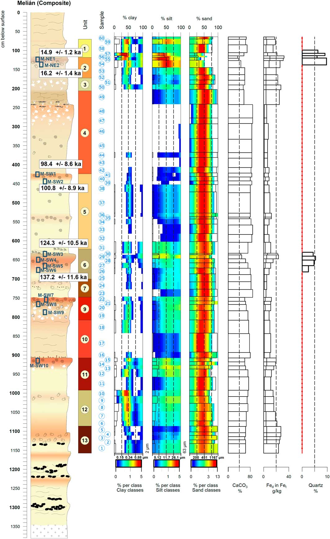
Melián section including analytical data sample wise. Sequences with no available data indicated by red lines (according to Roettig et al., Reference Roettig, Kolb, Wolf, Baumgart, Richter, Schleicher, Zöller and Faust2017, modified). See Figure 3 for key. (For interpretation of the references to colour in this figure legend, the reader is referred to the web version of this article.)

Grain-size distribution
Grain-size distribution was measured at GFZ Potsdam using the Horiba LA-950 laser diffraction particle sizer. The samples (air-dried) were suspended with sodium pyrophosphate for 24 hours. In accordance with the origin of the samples (dominance of sediments of shelf origin), no calcium carbonate or organic material was removed. The samples were measured consecutively five times. The plotted values correspond to the medians of 80 classes between 0.058 and 2500 µm.
All grain-size plots were created using the software “R.” The respective distributions were plotted as heatmaps (Schulte, 2016) representing the percentage of each class. According to Roettig et al. (Reference Roettig, Kolb, Wolf, Baumgart, Richter, Schleicher, Zöller and Faust2017), the attribution of colour is logarithmic for three single matrices: first matrix, the clay fraction (0.058 to 1.981 µm); the second matrix, the silt fraction (1.981 to 58.953 µm); and the third matrix, the sand fraction (58.953 to 2500 µm). Cumulated percentages of each matrix are presented at the top of the grain size figures (section-wise).
Measured Fe contents
After pressure digestion with concentrated nitric and hydrofluoric acid by atomic adsorption spectrometry, the Fe contents were measured. Similarly, selected samples were measured to quantify the elemental composition of the clay fraction (treated with HCl and untreated). The clay fraction was extracted by means of the gravitational Köhn method (using Atterberg cylinders). CaCO3 content was determined using Scheibler apparatus by treating the samples with hydrochloric acid (Schlichting, Reference Schlichting, Blume and Stahr1995).
XRD analysis
The determination of clay minerals of the selected samples was carried out at the University of Cordoba. Mineralogical clay fraction analysis by XRD was performed using an XRD Siemens diffractometer with a copper lamp. The range of scan was 2–17°, and 1º per minute. Clay minerals were classified according to the Brindley and Brown (Reference Brindley and Brown1980) method, identified and semi-quantified according to Montealegre Contreras (Reference Montealegre Contreras1976) using peak areas and relative index reflection of each clay mineral.
RESULTS
Encantado section
Carbonate sands
In general, this section (Fig. 3) is composed of different generations of accumulated carbonate sands and corresponding palaeosurfaces on top of each generation. Because they are of shelf origin, carbonate sands offer a high proportion of CaCO3, up to >90%. The almost pure material of shelf origin ranges in colour from very pale brown (10 YR 8/4), to yellow (10 YR 8/6) or reddish yellow (7.5 YR 6/6). These middle sand-dominated carbonate sands are almost free of quartz and have a very low iron content. For example, Unit 11 shows values of 5.42 g/kg Fet and 0.97 g/kg Fed. Consequently, these layers also present very low Si contents.
Soil sediments
Occasionally, soil sediments replace carbonate sands as parent material, with a CaCO3 content of 40–70%. Accordingly, Units 9 and 13 of the Encantado section are reddish yellow (7.5 YR 6/6), showing a minimum content of 70% sand, up to 25% silt, and 10% clay. The amount of Fet in these soil sediments varies between 12.38% (Unit 9) and 33.69% (Unit 13). The amount of silicon reaches 11.1 wt% (Unit 9). The highest clay value (>45%) of the whole section is related to the soil sediment in the uppermost part of Unit 7.
Palaeosurfaces
The palaeosurfaces differ in their characteristics, as maybe expected. The lowest CaCO3 value of 16% is related to Unit 7 (strong brown colour [7.5 YR 4/6]). The highest value reaches almost 75% CaCO3 (Unit 8), in combination with a reddish yellow (7.5 YR 6/6) colour. The silt content in layers of palaeosurfaces reaches 40–50% (Units 1–3, 7, 9, and 13); clay content shows a maximum of 25% (Unit 13). The highest Fet content is 20–40 g/kg (Units 1–3, 7, 9–11, and 13). Silicon values of palaeosurfaces normally range between 20 and 41 wt%, and calculated quartz content reaches more than 7% (e.g., Unit 9). In agreement, the thin section E3-7 (Unit 9) shows the highest amount of quartz (Table 1). The lowest value yields roughly 2% of quartz (uppermost part of Unit 10). Additionally, some parts consist of materials of volcanic origin. Thus, Unit 12 presents constituents of Lapilli, the same way Units 6–8 feature mafic minerals/tephra material. Of course, many parts show admixtured basaltic rock fragments, but these are related to relocation processes originating from the basaltic surrounding instead of concurrent volcanic activity. The combination of palaeosurfaces and volcanic imprint means that iron content can reach up to 40.69 g/kg Fet and 11.91 g/kg Fed. The thin sections (Table 1) support the imprint of volcanic material, e.g., volcanic glasses as observed in Units 4, 7, and 8.
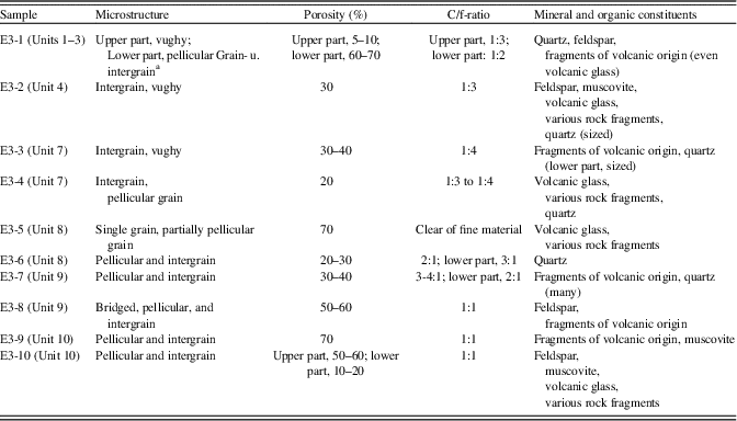
Micromorphological features of the Encantado section. See Figure 3 for sample location.

a See Stoops, Reference Stoops2003.
As reported by Roettig et al. (Reference Roettig, Kolb, Wolf, Baumgart, Richter, Schleicher, Zöller and Faust2017), the infrared-stimulated luminescence (IRSL) data classify the lower parts of this section in ages older than 366.3±34.2 ka. The youngest age of this section (130.9±11.0 ka) is linked to Unit 5.
Melián section
Carbonate sands
In the Melián section, the middle to coarse sand grained carbonate sands of shelf origin are characterised by a CaCO3 content of up to 86.6% (e.g., Unit 5, lower part). These sediments are a reddish yellow (7.5 YR 7/6; Unit 14) and yellow (10 YR 7/6; Units 6–8) colour. Iron content can be up to 11.54 g/kg Fet and 2.22 g/kg Fed.
Soil sediments
Just the parent materials of Unit 9 and 10 (Fig. 4) are linked to soil sediments. Both Units are characterised by a succession of different layers featuring relocated molluscs. The soil sediment of Unit 10 is reddish yellow (7.5 YR 7/6) in colour, showing 75.4% CaCO3 with 11.21 g/kg Fet and 1.95 g/kg Fed.
Palaeosurfaces
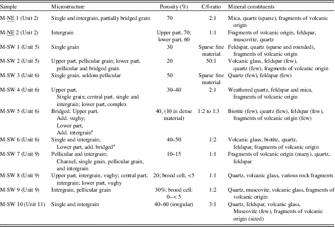
The palaeosurfaces of the Melián site feature 40–80% CaCO3, the lowermost is related to Unit 6. Accordingly, Fet values reach their maximum in Unit 6, offering 23.56 g/kg combined with 5.40 g/kg Fed, whereas the quartz content of Unit 6 reaches only 5%. Units 1 and 2 show higher amounts of quartz of 6 to ~10%. The thin sections M-SW 8, 9, and 10 indicate highest quartz content in Units 9 and 11.
In stratigraphic order, Unit 7, Unit 6, and Unit 5 are the first units clearly featuring volcanic imprint. They are characterised by impurities of mafic minerals. Correspondingly, thin sections M-SW 2 (Unit 5) and M-SW 6 (Unit 6) show the admixture of volcanic glasses (Table 2). Additionally, the upper most part of Unit 4 shows volcanic imprint by accumulation of tephra material. Units 1–3 also feature several impurities, supported by thin section M-NE 2, showing a significantly high proportion of fragments of volcanic origin.
Micromorphological features of the Melián section. See Figure 4 for sample location.

a See Stoops, Reference Stoops2003.
Unit 6 is dated 137.2±11.6 ka. The palaeosurface on top of Unit 5 is dated to roughly 100 ka. The youngest dated palaeosurface is underlain by sediments aged 16.2±1.4 ka and overlain by deposits aged 14.9±1.2 ka.
Jable 1 section
Carbonate sands
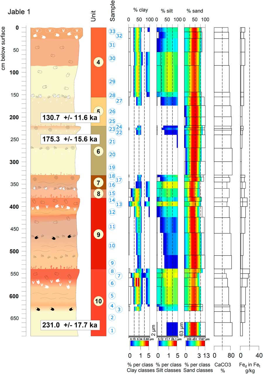
The carbonate sands range in colour from pink (10 YR 8/4), very pale brown (10 YR 8/4 and 7/4), to reddish yellow (7.5 YR 7/6). Dominated by the sand fraction (up to >95%), they feature very low amounts of iron. Fet content shows a maximum of 8.14 g/kg and Fed content a maximum of 1.89 g/kg (Fig. 5, Unit 4).
Jable 1 section including analytical data sample wise (according to Roettig et al., Reference Roettig, Kolb, Wolf, Baumgart, Richter, Schleicher, Zöller and Faust2017, modified). See Figure 3 for key. (For interpretation of the references to colour in this figure legend, the reader is referred to the web version of this article.)

Soil sediments
The central part of this section is dominated by soil sediments (Units 7–9 and the upper part of Unit 10) consisting of about 70% to >83% CaCO3. These sediments are reddish yellow (7.5 YR 6/6) in colour and contain up to 25% silt and 10% clay (e.g., upper part of Unit 10). The amounts of iron reach a maximum of 11.76 g/kg Fet and 3.34 g/kg Fed (Unit 10, upper part).
Palaeosurfaces
The CaCO3 content of different palaeosurfaces of this section presents values between 52% (Unit 10) and 80% (Unit 6). Unit 10 presents the highest clay content (25%) of the whole section. The colours of the different palaeosurfaces range from strong brown (7.5 YR 5/8; Units 9 and 10) to reddish yellow (7.5 YR 6/6 and 7/6; Units 6 and 7). Thus, the Fet content reaches its maximum of 20.18 g/kg and Fed content of 5.42 g/kg related to Unit 10.
Units 6–8 show volcanic influence featured by impurities of mafic minerals (tephra material). The section is dated to 231.0±17.7 ka in the lowermost part. On top (2 m below current surface), the sediment was dated to 130.7±11.6 ka. For a more detailed description of the sections, refer to the study by Roettig et al. (Reference Roettig, Kolb, Wolf, Baumgart, Richter, Schleicher, Zöller and Faust2017).
DISCUSSION
Soil formation versus imprint of dust
Soil-forming processes
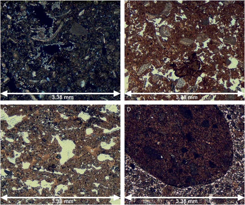
Our micromorphological analyses (Fig. 6, Tables 1 and 2) indicate that the weakest in-situ soil formation (e.g., Unit 5, Melián section) in carbonate sands on Fuerteventura is characterised only by features of very weak de- and recalcification. These processes seem to take place within very short distances (excluding root casts), thereby they are not comparable to those decalcification processes like those reported from mid-European loess sections that reveal a marked near-horizontal boundary of a late glacial and Holocene decalcification front (Meszner et al. Reference Meszner, Kreutzer, Fuchs and Faust2013). In carbonate sands, voids and pores are favored areas of recalcification (c.f. Fig. 6A thin section E3-7, central part). These processes take place in an environment with more than 75% CaCO3 (e.g., Unit 6 of the Encantado section). In these calcareous carbonate sands, features of de- and recalcification show a patchy distribution.
Thin sections showing features of: (A) de- and recalcification (sample E3-7, central part of thin section, not HCl treated: partially decalcified, secondary carbonates around voids and weathered ash grains); (B) oxidation of manganese (samples E3-3, upper part of thin section, not HCl-treated: besides silt-sized quartz grains, irregular autochthonous impregnation of Manganese); (C) relocated aggregates including fragments of clay illuviation (sample E3-2, upper part of thin section, not HCl-treated: large fragments of former soil containing illuvial clay); and (D) rounded reworked material (sample M-SW7, lower part of thin section, not HCl-treated: rounded reworked aggregates often consist of dense brown fine material of a much more intensively developed soil). For sample location, please see Figures 3 and 4. (For interpretation of the references to colour in this figure legend, the reader is referred to the web version of this article.)

Further features of weak in-situ soil formation are concretions of manganese and iron (Fig. 6B, thin section E3-3, upper part). It seems to be impossible that these concretions have been relocated. The outer rims of the manganese-coated grains are irregular and must be autochthonous. One special feature is presented by the upper part of Unit 4 of the Encantado section that indicates clay illuviation (Fig. 6C, thin section E3-2, upper part) incorporated in large fragments and aggregates, perhaps related to former soil formation. Hence, clay illuviation took place prior to reworking, and it is unclear if the respective soil formation took place directly in carbonate sands. So far, on Fuerteventura solely Pomel et al. (Reference Pomel, Miallier, Fain and Sanzelle1985, p. 59) described a section close to the village of Pajara including a palaeosol (Rhodoxeralf, “sol brun-rouge calcifère”) featuring cutanes, as an indicator of in-situ clay illuviation. Pal et al. (Reference Pal, Srivastava and Bhattacharyya2003) described the illuviation of clay and the formation of pedogenic CaCO3 as two concurrent processes concerning alfisols of the semi-arid part of the Indo-Gangetic Plain. Albeit, Unit 4 is characterised by a CaCO3 content of more than 70% without featuring any indicative decalcification. Thus, from our findings on Fuerteventura, we do not consider these clay coatings and aggregates as in-situ features because they were detected in reworked material still containing a very high amount of CaCO3. Thin section E3-4 (Unit 7 of the Encantado section) indeed shows coatings (clay and iron oxides) of coarser grains, but the rounded rims clearly suggest relocated sediments. We did not observe characteristic structures like alignments of clay enrichment, which one would expect from clay illuviation in such sandy material. In combination with detecting only in-situ concretions of iron and manganese (Fig. 6B, thin section E3-3, upper part), our study is in line with Kruse and Meyer (Reference Kruse and Meyer1970), who did not find evidence of further pedogenetic processes other than decalcification and oxidation of iron in sequences in Moroccan coastal dunes.
Formation of clay minerals
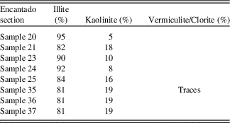
Micromorphological analyses did not support neo- or transformation of clay minerals. The autochthonous minerals of volcanic origin should transform to smectites (Jahn, Reference Jahn1988; Zarei, Reference Zarei1989), but only under hydromorphic conditions (von Suchodoletz et al., Reference Von Suchodoletz, Kühn, Hambach, Dietze, Zöller and Faust2009). The free drainage conditions on Fuerteventura did not facilitate any in-situ smectite formation (Table 3).
Results of X-ray diffraction analysis.

As formation of kaolinite is almost impossible in settings of calcareous parent material, we assume that all measured illite and kaolinite (Table 3) are allochthonous and reached the system from Saharan dust, as reported by Criado and Dorta (Reference Criado and Dorta2003) and von Suchodoletz et al. (Reference Von Suchodoletz, Kühn, Hambach, Dietze, Zöller and Faust2009).
Fine material
Unit 9 of the Encantado section (Fig. 3) is characterised by decreasing values of CaCO3 and increasing amounts of clay and silt from the bottom to the top of the section. At the Encantado section silt content can be up to 40–50% (e.g., Units 7 and 9). Higher silt content suggests increased dust imprint (von Suchodoletz et al., Reference Von Suchodoletz, Kühn, Hambach, Dietze, Zöller and Faust2009; Muhs et al., Reference Muhs, Budahn, Skipp, Prospero, Patterson and Bettis2010; Scheuvens et al., Reference Scheuvens, Schütz, Kandler, Ebert and Weinbruch2013); however, increased clay content should indicate more intense soil formation due to a lower c/f-ratio. Yet, despite a lower content of fine material (clay and silt), thin section E3-8 (Table 1) features a lower c/f-ratio (1:1) in comparison to thin section E3-7 characterised by a c/f-ratio of 4:1 to 3:1. Firstly, due to a higher silt and clay content, E3-7 (the uppermost part of Unit 9) seems to be dominated by dust imprint. Secondly, this suggests more intense soil formation in E3-8 than in E3-7. Assuming more intense soil formation related to dune fields on Fuerteventura involves notable de- and recalcification processes and oxidation of iron and manganese. Fuerteventura soils are not comparable, however, to intense soil-formation processes of tropical regions, for instance.
Imprint of dust
In addition to the aforementioned features, the quartz content is also a convincing marker of dust imprint in the eastern Canary Islands (Misota and Matsuhisa, Reference Misota and Matsuhisa1995; Menendez et al., Reference Menéndez, Díaz-Hernández, Mangas, Alonso and Sánchez-Soto2007; von Suchodoletz et al., Reference Von Suchodoletz, Glaser, Thrippleton, Broder, Zang, Eigenmann, Kopp, Reichert and Zöller2013). Except for one sample (~2% quartz, uppermost part of Unit 10 of Encantado), the quartz content of layers related to palaeosurfaces is quite similar (ca. 4–7%), whereas layers of middle to coarse sand-dominated biogenic carbonate sands are almost free of quartz. The similar quartz content suggests aggrading soils due to a relatively steady dust accumulation. We assume that increasing Si values are mainly related to increased volcanic imprint.
Faust et al. (Reference Faust, Yurena, Willkommen, Roettig, Richter, Richter, Suchodoletz and Zöller2015) proposed a hypothesis to explain sediment-accumulation dependent soil-forming intensity on Fuerteventura. Less accumulation of sediment would result in higher soil-forming intensity indicated by soil reddening. We cannot rule out the possibility of reddening caused by higher accumulation rates of dust including hematite as a constituent, however, in accordance with zu Leiningen (Reference Zu Leiningen1915), Dan and Yaalon (Reference Dan and Yaalon1966, Reference Dan and Yaalon1968), Dan (Reference Dan1990), and Yaalon (Reference Yaalon1997). Similarly, Jahn (Reference Jahn2010) identified iron oxides of higher crystallinity besides quartz, kaolinite, and illite as indicators of dust material on Lanzarote, and Menéndez et al. (Reference Menéndez, Pérez-Chacón, Mangas, Tauler, Engelbrecht, Derbyshire, Cana and Alonso2013) measured up to 6% of hematite as a constituent of dust material.
Therefore, adding to the interpretation by Faust et al. (Reference Faust, Yurena, Willkommen, Roettig, Richter, Richter, Suchodoletz and Zöller2015), even higher dust-accumulation rates could contribute to the reddening of the sediments. Hence, more intense reddening is not necessarily caused by more intense soil formation. Kruse and Meyer (Reference Kruse and Meyer1970) reported autochthonous CaCO3-coated primary iron exposed by decalcification in Moroccan dune deposits. Subsequently, the primary iron was oxidised and reddened the material. This process is called “Entkalkungsrötung” (“decalcification reddening”). Ultimately, it is hard to determine and distinguish between the contribution of dust (i.e., by the content of hematite) and the influence of in-situ reddening. Thus, the most plausible hypothesis supports that dust accumulation and in-situ reddening are two concurrent processes.
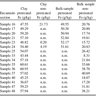
Hence, we have to mention the combination of dust imprint and in-situ reddening as an in-situ soil-forming process. Extending the study by Kruse and Meyer (Reference Kruse and Meyer1970) we assume, CaCO3-coated primary iron as constituents of dust, which are leached after deposition and transform into hematite (Andreucci et al., 2012). Our analyses of elemental composition of the clay fraction (comparing the results of pretreated [HCl] and non-pretreated samples, see Table 4) support the assumption of CaCO3-coated iron particles. The values of measured pretreated samples are many times higher than the values of non-pretreated samples. Considering the results from measured elements, the values of pretreated samples show higher iron contents. For example, sample 24 of Unit 9 (Encantado section) features 4.19 g/kg Fe (clay fraction, non-pretreated) versus 54.4 g/kg Fe (clay fraction, pretreated). In addition, results of the respective bulk sample (clay + silt + sand) show 51.61 g/kg Fe (pretreated). This implies that all of the iron is linked to the clay fraction. The high CaCO3 content (52% in Unit 9 of the Encantado section, sample 24) suggests an incomplete leaching of CaCO3, but possibly a noteworthy contribution to reddening by CaCO3-coated iron particles as constituents of dust.
Measured Fe-contents of clay fraction and bulk samples (pretreated and non-pretreated; n.m., not measured)

Determination of periods of palaeosurface formation
Remarkably, we recurrently observed the following sequence of layering (from the bottom to the top of each stratigraphic sequence) at different aeolian sections: (1) pure carbonate sands (unconsolidated aeolianites); (2) material influenced by dust imprint and soil formation; (3) soil sediment (relocated by water-induced erosion). or (1) pure carbonate sands (unconsolidated aeolianites); (2) soil sediment (relocated by water-induced erosion); and (3) material influenced by dust imprint and soil formation.
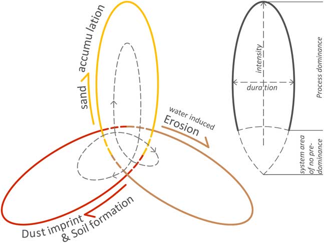
In contrast, we rarely observed carbonate sands (without the influence of dust imprint, soil formation, or volcanic imprint) relocated by water-induced erosion. This allows us to assume a simplified alternation of sand supply, soil formation including dust imprint, and finally water-induced erosion and reworking (Fig. 7). Occasionally, this sequence is followed by further dust imprint and soil formation.
Process cyclicity. Sectors of predominance of “sand accumulation” (yellow), “dust imprint and soil formation” (red), and “water-induced erosion” (greyish-brown) result in process cyclicity. The grey line shows an example of one cycle. The idealised sequence starts with sediment supply (grey line in yellow sector, following the direction of the arrow) taking place within a relatively short period but being of high intensity of supply (please see markings of “duration” and “intensity” on the right side), followed by a longer lasting but less intense period of dust imprint and soil formation, making the sediment vulnerable to water-induced erosion, finally (following the grey line: short period of water-induced erosion of low intensity). This example is derived from interpretation of Unit 11. (For interpretation of the references to colour in this figure legend, the reader is referred to the web version of this article.)

Thus, we suggest morphological resistance as a main reason for the mentioned succession of processes, i.e., the unconsolidated aeolianites are characterised by middle to coarse-grained sand. Coarse grain size is related to a value of water permeability of almost 250–675 cm/d (dependent on bulk density; Ad-hoc Arbeitsgruppe Boden, 2005). The high permeability causes a high morphological resistance to water-induced erosion. Similarly, this is reflected in recent dune fields, where development and preservation of depression lines and discharge pathways is strongly inhibited. Additionally, during periods of predominant sand supply, the surface is subject to strong aeolian dynamics, which continuously rework the sediments. Finally, the sand supply has to decrease to simultaneously facilitate stable surface conditions and the development of depression lines.
In case of decreasing sand supply, the prevalence of dust accumulation and soil-forming processes causes the fining of near-surface sediments, resulting in decreased water permeability and reduced morphological resistance. Thus, vulnerability to water-induced erosion increases. Furthermore, Jahn (2010) proposed an increasing water-storage capacity caused by the substrates’ fining due to dust imprint. Indeed, this coupling leads to the self-enhancement of stable surfaces and dust imprint, leading to soil-forming processes and at least changing successively the value of water permeability in the course of admixture of fine material.
Consequently, sand supply seems to be the primary control quantity in allowing site-specific geomorphic stability, related to dust accumulation and soil-forming processes, in view of forming palaeosurfaces. On Fuerteventura, we mainly consider three possible drivers controlling the supply of carbonate sands of shelf origin: (1) changing wind directions, (2) volcanic activity, and (3) changing sea level.
Wind direction
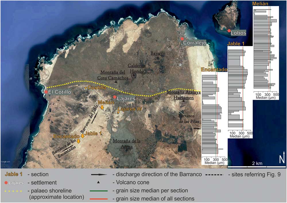
In general, it is conceivable that the supply of carbonate sands may depend on a particular dominant wind direction. On the case of Fuerteventura, Coudé-Gaussen and Rognon (Reference Coudé-Gaussen and Rognon1988) hypothesised a westerly wind direction during periods of sand supply. In contrast, Alcántara-Carió et al. (Reference Alcántara-Carió, Fernández-Bastero and Alonso2010) suggested more intense trade winds alternating with easterly winds during periods of favored sand supply. Criado et al. (Reference Criado, Guillo, Hansen, Hansen, Lillo, Torres and Naranjo2004) postulated wind directions similar to northeast trade winds seen nowadays. Roettig et al. (Reference Roettig, Kolb, Wolf, Baumgart, Richter, Schleicher, Zöller and Faust2017) suggested that the archives of aeolianite palaeosol sequences indicate northerly wind directions during periods of prevalent sand supply. Two facts support the latter suggestion. First, the assumption that the coarser the material the closer the sediment source is well-supported by the distribution of grain sizes within the three studied sections. Figure 8 provides the grain- size medians of each section in relation to the grain-size median of the whole area (median of all sections).
Satellite image of the study area, including grain-size median plots of the Encantado, Jable 1, and Melián sections including the approximate location of a former coastline, described by Ruiz et al. Reference Ruiz and Torres Cabrera2011 (based on Google Earth, modified). (For interpretation of the references to colour in this figure legend, the reader is referred to the web version of this article.)

The southernmost Encantado section shows a median of 294.7 µm, whereas the northernmost Melián section presents a tendency to coarser material with a median of 355.7 µm, and Jable 1, located in between Melián section and Encantado section,reveals a grain-size median of 331.4 µm. This trend could be influenced by the site-specific preservation conditions and therefore more preserved finer material. Nevertheless, we observed the same tendency comparing distinct correlated sand layers (respective Units). For example, the parent material of Unit 5 shows the following median values: 290.7–363.6 µm (sample 43–44, Encantado), 421.2–350.0 µm (samples 25–26, Jable 1), 344.3–437.6 µm (samples 32–33, Melián), or, in the case of the carbonate aeolianites of Unit 11, 267.9 µm (samples 13, Encantado) versus 300.4 µm (samples 11, Melián). This coarsening of grain sizes towards a northern direction suggests a sand supply related to northerly wind directions.
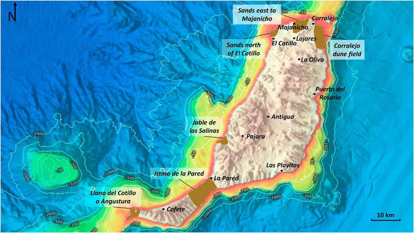
The second aspect refers to the distribution of carbonate sands taking the whole island of Fuerteventura into account. Apart from the palaeodune fields in our study area, we can outline the following areas of accumulated dune sediments (Fig. 10): (1) Llano del Cotillo o Angustura (on the southern tip of the island); (2) Istmo de la Pared and El Jable between the settlements of Jandia and La Pared; (3) Jable de las Salinas and Jable de Vigocho 5 km southwest of Pajara; (4) sand sheets in the north of El Cotillo (Los Lagos) and to the east of Majanicho; and (5) the Holocene dune field of Corralejo. All these areas are characterised by palaeodune fields fed by a shallow shelf area in a northern direction.
We did not find remnants of palaeodunes to the north of Las Playitas, despite a respective/corresponding shallow shelf offshore. Here, we have to point out that the potential source area offshore is located in a southeastern direction. Another counterexample is the area close to the village of Cofete on the southern tip of the island. Here, the coastline is exposed to a northern direction, but, unfortunately, we found only a very narrow shallow shelf area offshore. Again, there are no noteworthy accumulations of carbonate aeolianites. Ultimately, we can assume a source area exposed northward in terms of a wide shallow shelf offshore as prerequisites to generate an accumulation of unconsolidated carbonate aeolianites on Fuerteventura.
Volcanism
Volcanic activity is an important local controlling factor for dune accumulation. Hereby, the main influence on sand supply is exercised via interruptions of sediment cascades. Our study area is a perfect example to investigate the impact of volcanic activity on the formation of aeolianite sequences.
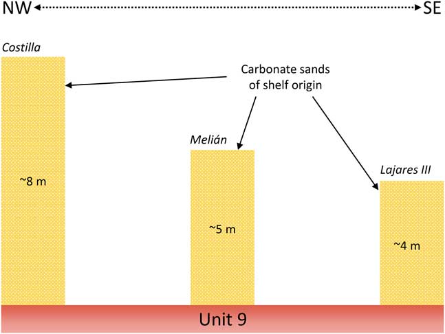
Based on stratigraphic findings, Roettig et al. (Reference Roettig, Kolb, Wolf, Baumgart, Richter, Schleicher, Zöller and Faust2017) assumed a change in sediment delivery around 185 ka and again at 135 ka. These time periods coincide with volcanic eruptions reported by Meco et al. (Reference Meco, Guillou, Carracedo, Lomoschitz, Ramos and Rodríguez-Yánez2002, Reference Meco, Muhs, Fontugne, Ramos, Lomoschitz and Patterson2011) and Criado et al. (2004). Moreover, Ruiz and Cabrera (Reference Ruiz and Torres Cabrera2011) suggested an old shoreline running from El Cotillo to Lajares to Montaña Atalaya Huriamen (Fig. 8, yellow dotted line). This corresponds with the distribution of palaeodune fields and sand sheets (Barranco del Jable and Barranco de los Encantados, Barranco de las Pilas), and with the huge basaltic lava sheet covering the northern part of the island. At its center there is a chain of volcanoes. Calderon Hondo and Bayuyo are included in this chain of volcanoes, and both are dated 135 ka (Meco et al., Reference Meco, Guillou, Carracedo, Lomoschitz, Ramos and Rodríguez-Yánez2002; Ruiz and Cabrera, Reference Ruiz and Torres Cabrera2011). Montaña de la Arena first erupted 185 ka (Edwards and Meco, Reference Edwards and Meco2000). These volcanic eruptions are assumed responsible for a major change in sediment supply, delivery, and accumulation. Accordingly, the Melián site shows a change in its sediment preservation. We suggest that the upper part of this section (starting with Unit 7) would have never been preserved without a change in the local characteristics. Until the mentioned volcanic events, the Melián site was characterised by high morphodynamics, situated close to the outlet of the catchment of Barranco del Jable (Roettig et al., Reference Roettig, Kolb, Wolf, Baumgart, Richter, Schleicher, Zöller and Faust2017). The volcanic activity caused a change in the base level of erosion by blocking the former outlet of the Barranco del Jable. We assume this change is responsible for better preserving conditions of the sediments of Units 1–7 at the Melián site. The assumption is supported by the IRSL age of 137.2±11.6 ka, related to Unit 6 of Melián. Also, we observed a change, namely a lack of further sedimentation, in the same stratigraphic position at the site of Encantado. We suggest that the lava flow inhibited further sediment supply because the vast lava field covered former dune fields, which, in turn, hindered the transportation of sand material. Differences in site-specific preservation conditions cannot be completely excluded, but there is no field evidence indicating that preservation and erosion are responsible for this feature at the Encantado section. Surprisingly, the Melián section features no cutoff from sediment accumulation (but better preservation conditions in the upper sequence as mentioned before). Faust et al. (Reference Faust, Yurena, Willkommen, Roettig, Richter, Richter, Suchodoletz and Zöller2015) investigated the Costilla section (the same as “Rosa Negra” in the literature; e.g., Damnati et al., Reference Damnati, Petit-Maire, Fontugne, Meco and Williamson1996). This section is located on the northern slope of the outcrops of Miocene volcanism (Fig. 8). Therefore, the section is located between the villages of Lajares and El Cotillo, just 2.5 km northwest of the Melián section. Faust et al. (Reference Faust, Yurena, Willkommen, Roettig, Richter, Richter, Suchodoletz and Zöller2015) described Costilla in detail, but the thickness of the upper part of the section was underestimated. They reported an age of 228±33 ka of the sediments below the so-called “marker horizon.” The “marker horizon” is equivalent to Unit 9 according to Roettig et al. (Reference Roettig, Kolb, Wolf, Baumgart, Richter, Schleicher, Zöller and Faust2017). Bouab and Lamothe (1997) dated the sediments above Unit 9 as 181±27 ka and 183±27 ka. Hence, in combination with our own investigation, we can conclude a possible relation to the period of volcanic activity. At Costilla, the sediments above Unit 9 are up to 8 m thick, whereas the respective sediments at Melián are approximately 5 m thick (Fig. 9). In turn, at the Lajares III section (also described by Faust et al., Reference Faust, Yurena, Willkommen, Roettig, Richter, Richter, Suchodoletz and Zöller2015) approximately only 4 m has accumulated. To summarize, in agreement with the volcanic activity at 185 ka and at 135 ka, we observed a lack of sediment accumulation at Encantado, and decreasing thickness of sand layers at Jable 1, whereas sedimentation continued at the sites of Costilla, Melián, and Lajares. The last three mentioned sites present a gradient of decreasing accumulation in an eastern direction. This leads to the assumption that the volcanic events at 185 ka and at 135 ka caused a cutoff from sediment delivery from a northern to northeastern direction. Correspondingly, mainly derived from the gradient of sediment accumulation at Costilla, Melián, and Lajares, we assume ongoing sediment delivery from a northwestern direction. The leeward positioning behind the basal complex of the site of Encantado inhibited its supply of sediment from a northwestern direction.
Simplified illustration of sediment thicknesses overlying Unit 9 of the Costilla, Melián, and Lajares III sections. For location of sections, please see Figure 8. (For interpretation of the references to colour in this figure legend, the reader is referred to the web version of this article.)

Bathymetric data showing areas of shallow shelf around Fuerteventura with marked accumulation areas of carbonate sands of shelf origin (orange/black; based on EMODnet, modified). (For interpretation of the references to colour in this figure legend, the reader is referred to the web version of this article.)

Possibly, a further eruption, maybe related to the chain of volcanoes of the Calderon Hondo or to the Montaña del Coto Camachos, situated further west (see Fig. 8), completed the basaltic barrier/lava sheet, as observed nowadays, and blocked off the western-to-northwestern sediment pathway. The archives of Melián, Lajares, and Costilla show a respective complete cutoff before 50 ka (47.5±6.5 ka at Lajares; Faust et al., Reference Faust, Yurena, Willkommen, Roettig, Richter, Richter, Suchodoletz and Zöller2015) and after 100 ka (98.4±8.4 ka; Roettig et al., Reference Roettig, Kolb, Wolf, Baumgart, Richter, Schleicher, Zöller and Faust2017). After this point in time (>50 ka), none of the sites (Encantado, Melián, Jable 1, Costilla, and Lajares III) experiences additional accumulation of sediments directly delivered from the shelf area. A period of volcanic activity around 51 ka is also supported by Pomel et al. (Reference Pomel, Miallier, Fain and Sanzelle1985), who described volcanism near to Pajara. The sites of Melián, Lajares, and Costilla, however, indicate clear features of volcanic activity, such as lapilli in respective stratigraphic position.
Sea level
Meco et al. (Reference Meco, Muhs, Fontugne, Ramos, Lomoschitz and Patterson2011) presented a curve of middle Pleistocene to Holocene ice volume (reverse sea level) combined with information related to marine deposits, palaeosols, and dune accumulations on the Canary Islands. According to these authors, palaeosols (indicated by “locust infestations”; Meco et al., Reference Meco, Muhs, Fontugne, Ramos, Lomoschitz and Patterson2011) are early indicators of interglacials, whereas sand supply took place during glacial sea-level low stands. Similarly, in their model of landscape evolution on Fuerteventura, Coudé-Gaussen and Rognon (Reference Coudé-Gaussen and Rognon1988) designated glacials of lowered sea level as periods of sand supply.
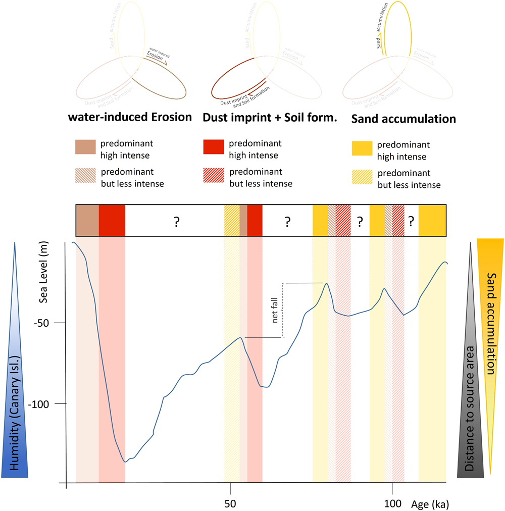
Undoubtedly, there is an effect of sea-level changes on supply of sediment of shelf origin. Pye and Tsoar (Reference Pye and Tsoar2009) summarised different approaches of linking sea-level fluctuations to sediment supply and landward migration of coastal dune systems. A first model, developed by Sayles (Reference Sayles1931), describes the possibility of sediment supply during sea-level low stand in accordance with the assumptions of Meco et al. (Reference Meco, Muhs, Fontugne, Ramos, Lomoschitz and Patterson2011) and Coudé-Gaussen and Rognon (Reference Coudé-Gaussen and Rognon1988). An alternative approach suggests sand supply during sea-level high stands (Bretz, Reference Bretz1960), and a third model by Schofield (Reference Schofield1975) describes the relevance of falling sea level for sediment supply and dune formation. According to the aforementioned approach, the spreading of dune systems is seen to be approximately proportional to the net fall of sea level during one specific sea-level fluctuation (c.f. Fig. 11). This implies that sea-level low stands would not correspond to periods of sediment supply. Instead, periods of falling sea level appear to be much more relevant.
(colour online) Conceptual approach of process relation to sea-level fluctuation.

According to the data reported by Roettig et al. (Reference Roettig, Kolb, Wolf, Baumgart, Richter, Schleicher, Zöller and Faust2017), dune sediments in northern Fuerteventura were dated around 171.2±15.4 and 175.3±15.6 ka, respectively. Other periods of sand supply took place around 137.2±11.6, 130.9±11.0, 130.7±11.6, and 124.3±10.5 ka. An additional period of significant sand supply dated to 100.8±8.9 and 98.4±8.6 ka. In the context of presented IRSL ages with a ±10% error, it seems inappropriate to support or exclude any of these proposed models linking sea-level changes with periods of sand supply. From a dating perspective, younger sediments should be much more useful. Unfortunately, because of the previously mentioned cutoff from supply of sediments of shelf origin no later than ca. 50 ka caused by volcanic activity, younger sediments are non-existent in the investigated aeolianite sections. Aside from the dating error, the ages reported by Roettig et al. (Reference Roettig, Kolb, Wolf, Baumgart, Richter, Schleicher, Zöller and Faust2017) least contradicts the concept (Schofield, Reference Schofield1975) of predominant sediment supply during falling sea level.
If we take a look at the current conditions of the dune field close to Corralejo (c.f. Fig. 1), we observe persistent but less intense sediment supply during a phase of sea-level high stand, which is in accordance with Bretz (Reference Bretz1960). Less intense sediment supply means a sediment supply just high enough to form barchans and sand sheets (compare Criado and Naranjo, Reference Criado and Naranjo2011). Derived from this observation and with regard to the process cyclicity presented in Figure 7, less intense sediment supply should be followed by high availability of sediment during falling sea level. Here, in turn, it is important to consider the distance between the dune field (and our current archives) and the source area. Continually falling sea level is accompanied by strictly retreating shoreline in shallow shelf areas. Accordingly, the newly exposed areas as main sources of sand move away from the dune field, initially resulting in decreasing sand supply. This relationship is illustrated in the conceptual idea in Figure 11. In contrast to Coudé-Gaussen et al. (Reference Coudé-Gaussen, Rognon, Bergametti, Gomes, Strauss, Gros and Le Coustumer1987) and Meco et al. (Reference Meco, Muhs, Fontugne, Ramos, Lomoschitz and Patterson2011), who suggested dune formation during arid glacial maxima, we assume a short period of high availability of coarse sand, with subsequent landward migration at the beginning of falling sea level. In our study sites, we often observed more sand sheet-like deposits of sediments instead of real dune accumulation. This could be caused by the long distance from the source area. Perhaps the material was just too coarse or the wind transport capacity was too low, thus resulting in a sand sheet-like accumulation.
Variations in humidity
Besides the great influence of sediment supply on the development of palaeosurfaces, changes in humidity should also be taken into consideration. In contrast to the global tendency toward more arid conditions during glacials, the Canary Islands seem to have experienced more moist conditions (Yanes et al., Reference Yanes, Yapp, Ibáñez, Alonso, de-la-Nuez, Quesada, Castillo and Delgado2011, Reference Yanes, García-Alix, Asta, Ibáñez, Alonso and Delgado2013). Correspondingly, Rognon and Coudé-Gaussen (Reference Rognon and Coudé-Gaussen1996) assumed western wind directions for the last glacial maximum in latitudes between 28° to 35°N, including the Canary Islands. Equally, von Suchodoletz et al. (Reference Von Suchodoletz, Oberhänsli, Hambach, Zöller, Fuchs and Faust2010), who worked on loess-like deposits on Lanzarote, concluded increased humidity during glacial periods, possibly caused by stronger westerly winds. The Cooperative Holocene Mapping Project (COHMAP) members (1988) already pointed out that glacial periods are accompanied with a southward displacement of the westerlies, causing increased moisture in northwest Africa. Accordingly, Bush and Philander (Reference Bush and Philander1999) described weakened easterly and stronger westerly winds near the African west coast (20°N). Furthermore, stronger northerly winds were calculated concerning the latitudes beyond 20°N (>20°). In the case of the Canary Islands, a northern-to-northwestern wind direction could be assumed. Similarly, the PMIP-2-scenarios support the assumption of the mentioned southward displacement of westerlies, such as those stated by Laîne et al. (Reference Laîné, Kageyama, Salas-Mélia, Voldoire, Rivière, Ramstein, Planton, Tyteca and Peterschmitt2009), whereby a southward shift and an eastward extension of the storm track for the Northern Hemisphere was reported.
Based on these ideas, we assume a simplified pattern for the eastern Canary Islands. The lower the sea level, the more humid conditions prevail over the eastern Canary Islands. Consequently, the potential for soil formation increases with falling sea level (see Fig. 11).
CONCLUSION
Generally, soil-forming processes in palaeodune fields of Fuerteventura are of weak intensity. They are usually constrained to processes of de- and recalcification and processes of recrystallization of iron and manganese. In the individual case Unit 4 of the Encantado section, relocated material illuviation features of former soil formation were detected, but composition of parent material related to the former soil formation remains unknown.
Hematite as a constituent of dust is assumed to contribute to the reddening of palaeosurfaces in these archives. In general, decalcification reddening is also considered an important process of soil formation. This implies that the combination of dust and in-situ reddening as possible jointly operating processes. As a result, we assume Saharan CaCO3-coated iron particles were leached after deposition, transformed to hematite, and intensified the colour of palaeosurface layers.
Based on the high morphological resistance of pure unconsolidated carbonate aeolianites, we propose a cyclicity model describing subsequent phases of: (1) sand accumulation; (2) dust imprint and soil formation, and (3) water-induced erosion.
On Fuerteventura, sand supply and accumulation seem to be a main controlling factor for the development of persistently exposed palaeosurfaces. In turn, changing wind direction, causing periods dominated by sediment supply/accumulation could be excluded. The palaeowinds within the last ~400 ka seem to be linked to northern directions (northwestern to northeastern).
Regarding the study area, periods of predominant sand accumulation are assumed to occur right after sea-level maxima during periods of falling sea level. The higher the baseline value of sea level, the more sand could have accumulated at our study sites. This assumption is supported by a simple function of falling sea level and an increasing distance between study sites and source area of carbonate sands. Thus, the lower the sea level, the greater the distance between source area and current sediment archives.
Volcanic eruptions massively modified the supply and availability of carbonate sands of shelf origin. A complex history of blocking situations by lava flows largely controlled the sediment supply on northern Fuerteventura. This happened primarily in two ways: (1) sediment pathways were closed by lava flows; and (2) source areas (i.e., shallow shelf areas) were covered by lava flows.
Apart from volcanic periods around 180 and 135 ka, the sedimentary archives point to further volcanic activity no later than ca. 50 ka. After that point in time, all studied sections were cutoff from supply of sediments of shelf origin. By this period, the study area became a palaeodune field. Hence, it seems inappropriate to link the accumulation, or lack thereof, of carbonate sands of shelf origin to only one factor (e.g., sea level).
Apart from sand supply and accumulation, humidity is suggested to have been higher during glacial periods, increasing the potential of surface stability of dust accumulation and soil-forming processes. Thus, we conclude that the best conditions for surface stability occur immediately after glacial maxima during periods of starting transgression. Further IRSL data will enable us to gain a deeper understanding of landscape evolution as registered in the sedimentary archives of northern Fuerteventura.
ACKNOWLEDGMENTS
We are very thankful to Maria Tarquis Gongora and Don Manuel Gutierrez Ruiz, who supported us and always permitted access to important study sites. Special thanks to Michael Dietze for coordinating the grain-size measurements and to Anja Schleicher for coordinating the XRF measurements at the GFZ Potsdam. Many thanks to Sascha Meszner and Michael Zech for intensive discussions. Special thanks to Beate Winkler, who did the measurements at the laboratory of the TU Dresden. We are very thankful for all ideas and advices from the two anonymous reviewers and the editors. Many thanks to Elizabeth Kelly for proofreading. This work was supported by the German Research Foundation (FA 239/18-1). Support of the National Research, Development and Innovation Office (NKFI) under contract NKFI K120620 (for G. Varga) is gratefully acknowledged.
SUPPLEMENTARY MATERIAL
To view supplementary material for this article, please visit https://doi.org/10.1017/qua.2018.52