
Introduction
In comparison with earlier periods, our knowledge of twentieth-century history may appear to have fewer gaps as a result of the extensive written and photographic records and the memories of living people. Yet, even for this recent period, there are places without a documented history—localities subject to different rules and that were intended to remain secret, concealed from society and forgotten (e.g. Fowler Reference Fowler2008; Hanson Reference Hanson2010: 157; Kiarszys Reference Kiarszys, Stichelbaut and Cowley2016). Archaeology, with its central focus on the material remains of past human activities, is well suited to the study of such places.
The Cold War has recently been the topic of a growing number of archaeological publications. Some focus on abandoned military installations, while others investigate the material remains of totalitarianism and its impact on the everyday life of local populations (e.g. Beck Reference Beck, Schofield, Johnson and Beck2002; Dolff-Bonekämper Reference Dolff-Bonekämper, Schofield, Johnson and Beck2002; Whorton Reference Whorton, Schofield, Johnson and Beck2002; Fowler Reference Fowler2008; Hanson Reference Hanson2010; Burström et al. Reference Burström, Acosta, Noriega, Gustafsson, Hernández, Karlsson, Pajón, Jaramillo and Westergaard2013; McWilliams Reference McWilliams2013; Rak et al. Reference Rak, Funk, Starková, Stichelbaut and Cowley2016). All of these narratives conclude that the Cold War was not merely a state of mind, but a real phenomenon that had the power to influence every aspect of society. As noted by McWilliams (Reference McWilliams2013: 209–12), archaeological analyses of the Cold War are studies of the metaphor created within popular culture, as well as studies of material remains, which often contradict that metaphor. An archaeological perspective, therefore, can assist in achieving a better understanding of this period.
This article presents a case study of three abandoned Soviet nuclear warhead storage sites in Poland: object 3001 in Podborsko, around 35km from the Baltic Sea coastline and 10km south-east of Białogard; object 3002 in Brzeźnica Kolonia, approximately 65km south of Podborsko and 15km south of Borne Sulinowo; and object 3003 in Templewo, around 17km west of Międzyrzecz. The study is based on analysis of airborne laser-scanning (ALS) data, historical and modern aerial photographs, declassified satellite imagery (Corona and HEXAGON), CIA reports and documents from the archives of the Institute of National Remembrance of Poland. The aim is to evaluate the archaeological potential of the places that were to be ‘erased’ from history. I argue that such an approach may provide a qualitative narration of recent events, and help in the protection of abandoned Cold War military installations (e.g. Whorton Reference Whorton, Schofield, Johnson and Beck2002; Cocroft Reference Cocroft, Schofield and Cocroft2007; Schofield & Cocroft Reference Schofield and Cocroft2007).
Due to the very nature of such places, historical records for former top-secret military facilities often have numerous gaps. While information about some facilities was purposely omitted from official documentation, other details were never registered or were considered unimportant. Yet some undocumented activities may have left material evidence. For the three nuclear storage sites under discussion here, despite the declassification of the historical records covering the secretive years from 1969–1992 by the Polish archives house in 2006, very little is still known about their existence in general. In certain circumstances, the archaeological approach has the potential to address such inconsistencies through the integration and reinterpretation of archaeological and historical data. The archaeological approach also allows access to places that are currently disused but located in restricted areas, using techniques such as remote sensing and archival data analysis (e.g. Fowler Reference Fowler2005, Reference Fowler2008, Reference Fowler, Cowley, Standring and Abicht2010).
Two of the three former nuclear storage sites introduced here are now badly damaged: almost all of the buildings at Brzeźnica Kolonia and Templewo were demolished in the mid 1990s. The concrete road surfaces and most recyclable materials were removed. The only preserved structures are the highly durable ‘Monolit’ bunkers, although they have been plundered, had internal equipment removed and their entrances blocked with concrete plates. In 2011, a ‘Granit’ bunker at Templewo was demolished; the Granit bunker in Brzeźnica Kolonia still survives, but its gates are missing. Only the base at Podborsko has survived in relatively good condition. All three bunkers at Podborsko retain most of their original equipment and in situ gates. Although the site recently became part of the Museum of Polish Arms in Kołobrzeg, it is not yet protected by law. The lack of protection for abandoned Cold War military sites derives from official and academic conviction that they have no value and are too recent to be considered as cultural heritage. Despite this, I argue that they have the potential to increase our understanding of the general mechanisms related to such phenomena as conflict, totalitarianism and cultural identity.
The genesis
In late February 1965, joint Polish-Russian military manoeuvres took place at the military training ground at Drawsko Pomorskie in north-west Poland. These manoeuvres included the planned simulated use of the R-11M (SCUD A) tactical ballistic missile systems (Dziemba Reference Dziemba2018: 26–27). The use of tactical nuclear forces during the initial stage of a possible future war in Europe was considered critical for the success of a later conventional offensive (e.g. Heuser Reference Heuser1993). The manoeuvres at Drawsko Pomorskie were designed to test the best mode of transport and the time required to move nuclear warheads from the USSR to western Poland.
The Warsaw Pact's military analysts found the results of these tests to be unsatisfactory, as the convoys would be exposed to air attacks, unexpected delays and sabotage throughout their journey. It was too difficult to keep such a large operation secret, and the time required to deliver the warheads was considered far too long. It was concluded that, in the event of a war against NATO in Europe, the Warsaw Pact would be unable to respond to the threat in a timely fashion with its tactical nuclear arsenal. The decision was therefore made to build three nuclear warhead storage facilities in western Poland. The execution of this special task began in 1966 under the codename ‘Wisła’ (IPN 1966a).
The Wisła project in the historical archives
Knowledge of historical context is essential for interpreting archaeological remains from the Cold War era. Archival sources can offer valuable insight when confronted with material relics of past events (e.g. Hanson Reference Hanson2010: 158). But as official documents, military reports and governmental agreements do not provide comprehensive records, archaeological data can help to verify, complement or contest these documentary sources.
Files on the Wisła project were declassified in 2006 and are available in the archives of the Polish Institute of National Remembrance (IPN 1966a & b, 1967). The records consist of three volumes containing official documents detailing the construction of nuclear military sites, ordered by the Soviet leadership in Poland. As most of the paperwork was created before the newly built bases were handed over to the Soviet troops, they cannot be regarded as a complete set. The documentation covers only part of the lifespan of the nuclear bases.
The Wisła project started in November 1966 when military specialists began the search for potential locations for the nuclear bases. Several suitable locations were recommended, and three were chosen on the basis of: vicinity to Soviet units stationed in Poland; the presence of military airfields and rocket units capable of delivering the nuclear warheads; and proximity to major road and rail routes. Furthermore, to attract less attention, all bases were to be built adjacent to large and busy military training grounds. Forested landscapes with small hills were favoured, as the planned facilities could be concealed and protected more easily (IPN 1966a).
In February 1967, a document agreeing to “actions undertaken to improve combat readiness” (IPN 1966b: 468–71) was signed by military officials in Moscow. The document approved the construction of three nuclear warhead warehouses in the proposed locations. Poland was obliged to provide the infrastructure, based on Soviet plans, and to cover all of the costs. The machinery and equipment required for the storage, control and preparation of nuclear warheads were to be provided by the USSR. Following construction, control of the bases was handed to the Soviet army, and the Polish government had no further access to the sites. The warheads were under the exclusive control of the Russian army; in the event of war, a limited number of the warheads were to be shared with Polish units.
The works were carried out in strict secrecy, with only the highest-ranking Polish officers aware of the sites’ true purpose (IPN 1966b: 379–81). Special instructions were issued regarding the methods for disinformation and camouflaging the construction sites. The Polish People's Army engineering troops, for example, were informed that they were building barracks for Soviet communication units. Moreover, each unit could only access part of the facility and was therefore unable to appreciate the full plan or true function of the complex (IPN 1967: 335–40).
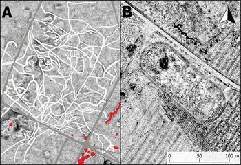
On 12 December 1969, the three completed bases were officially handed over to the Soviet army (IPN 1967: 61–315). This is the moment when the archival record goes silent—until 1991/1992, when the bases were abandoned by the withdrawing Russian army and ‘appeared’ for the first time in official public discourse in Poland. That archival silence leaves a gap of over 23 years in our knowledge of the sites’ history. Soon after completion of the bases, some documents were destroyed, and maps and blueprints were sent back to Moscow (e.g. IPN 1967: 328–31); there are no known plans of the facilities in the Polish archives, no information about their spatial organisation, field defences, landscape context or any potential modification. Aerial photographs taken by the Polish Cartographic Service from the end of the 1960s to the early 1990s were carefully censored and present no value for archaeological analysis (Figure 1A). Neither do the bases feature on any civilian or military topographical maps (Figure 1B).
A) Censored 1975 aerial photography of nuclear military base in Podborsko; B) a fragment of a civilian topographical map from the 1970s of the same area, with no indication of the presence of military installations (courtesy of GUGiK).

This situation creates an imbalance between the very detailed archival information available about the number of buildings originally constructed—their precise sizes, the calculated cost of construction and even the exact quantities of wire, cabling and piping installed—and the complete lack of data concerning their spatial distribution and use-history. This is where an archaeological approach becomes valuable, as it shows, for example, how each base had a different plan adapted to its local setting.
The dynamic palimpsests of latent conflict
Until its abandonment, a military base is never finished. It undergoes continuous transformation due to changing needs, often reflecting changing political ideologies, the devastating psychological effects of long-term latent conflict and propaganda-fuelled stress and fear. Some material traces within military facilities are also related to everyday life. Over time, new elements may be added to the military base, while others will be removed or remodelled. As noted in studies of medieval castles (e.g. Johnson Reference Johnson2002: 48), the surrounding defences may be reworked over time and zones of control altered. A similar situation may apply to other examples of military or quasi-military structures from other periods and geographic contexts. Dynamic change and constant improvements are the main evidence for the importance and intensive use of such places. A discontinuation of construction activity does not suggest that a military base has reached its ideal form, and therefore requires no further improvement; rather, it probably indicates obsolescence and impending disuse.
The process described above creates interpretative challenges. Archaeological research of Cold War military facilities usually focuses on abandoned places with different degrees of preservation. They consist of material traces created over an extended period of time. The metaphor of the ‘landscape palimpsest’ (e.g. Crawford Reference Crawford1953) can therefore be applied in the interpretation of such relics. It should be remembered, however, that not all of the structures detected by archaeological prospection were contemporaneous, and that not all of the original features survive. The ALS data used to create maps of the nuclear bases were collected very recently and document current states of preservation. Interpretation of such images therefore requires a critical approach; although the images reveal considerable details about the structures, they cannot be regarded as any more complete than the archival information.
Expanding hidden nuclear infrastructure
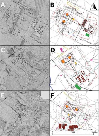
Podborsko (object 3001) is the best-preserved of the three nuclear sites discussed here. This is partly because, soon after abandonment, the living quarters and warehouse area were adapted as a state detention centre. Thus, access to the former base was restricted, and installations made of valuable materials were left intact. The nuclear bunkers at Podborsko, which lie in a separate zone to the detention centre, were recently opened to the public as part of the Museum of Polish Arms in Kołobrzeg. Here, I use the ALS data from object 3001 as a model to assist with interpretation of the other less well-preserved bases of Brzeźnica Kolonia (object 3002) and Templewo (object 3003) (Figure 2).
Airborne laser-scanning data visualisations (positive openness) and vectorised plans based on their interpretation: A–B) Podborsko; C–D) Brzeźnica Kolonia; E–F) Templewo (figure by G. Kiarszys).

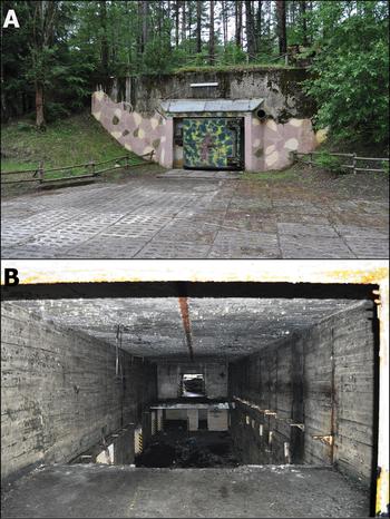
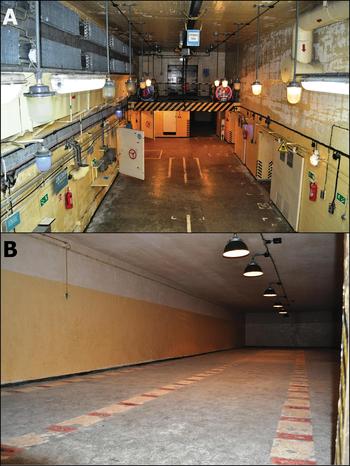
ALS data and historical documents show that, when the Podborsko base was handed over to the Soviet army in 1969, it comprised two main zones: the two Monolit nuclear bunkers (Figures 3–4) and an area with living quarters, car parks and warehouses. The spatial plan revealed through ALS data may suggest that a large zone (13ha) was set aside for the future construction of further nuclear storage facilities, but which were not subsequently built.
A) Monolit bunker in Podborsko, preserved in its original condition. The facade exhibits a modern fluorescent lamp and a recent failed attempt to reconstruct the camouflage pattern; B) the plundered interior of the Monolit bunker in Brzeźnica Kolonia (photographs by G. Kiarszys).

Interior of the Monolit bunker in Podborsko, with its original furnishings: A) main chamber with crane, loading ramp, and cooling and ventilation systems; B) one of four rooms used for storing nuclear warheads (photographs by G. Kiarszys).

The two Monolit bunkers were two-storey structures capable of accommodating tactical nuclear warheads. The buildings were equipped with an independent emergency power supply, water tank and an efficient ventilation system—a necessity as the warheads produced heat, which could damage their electronic circuits. There was also a laboratory and facilities for the workers, in case they were forced to spend several days locked inside. The bunkers were equipped with two cranes for lifting and moving the warheads, and serviced by two entrances, on opposite sides, each of which was reinforced by separate double gates made of steel and concrete with a room in between. The two bunkers were oriented at 90° to one another, probably in order to reduce the chance of both bunkers’ gates being destroyed by a single blast; in the event of a shockwave striking one bunker, the other bunker had a good chance of survival, as its gates would not be exposed to the same force (Figure 5A).
Consecutive phases of the transformation of the Podborsko base. Interpretation based on the analysis of the airborne laser-scanning data and satellite images (figure by G. Kiarszys).

The second zone at Podborsko is located at the south-eastern edge of the base (‘overbuild area’ on Figure 5). It comprised buildings of various functions, including living quarters, a cinema and dining room for 120 people, car parks, warehouses for military equipment and food, a hospital, a prison and guardhouses. The roads leading to the base were reinforced with concrete plates, which could withstand the movement of heavy military vehicles, but were also easy to camouflage; their greyish colour and perforated surface gave the appearance of an ordinary dirt road when seen from the air. The entire complex was surrounded by several fence lines. Each of the three nuclear bases had a shooting range (two at Brzeźnica Kolonia). At Podborsko, the shooting range was located on the northern edge of the base (Figure 5A).
Modifications to the Podborsko base started soon after it was handed over to the Soviet army. The first step was to establish a provisional line of defence in addition to the extant fence lines. The easiest way to achieve this was to prepare a system of foxholes along the perimeter road, outside the fencing. Over time, new guard posts were constructed in the surrounding forest. Some of these served as observation points, while others, located along the roads, were used as concealed checkpoints. A number of defensive positions were also prepared close to the Monolit bunkers. Not all of the foxholes shown in Figure 5, however, should be considered as contemporaneous. Conversely, the image is incomplete, as there are clearly visible gaps in the lines. Some were later backfilled or disused due to further construction at the base (Figure 5B).
The Russian unit stationed at the base was heavily mechanised. In the event of war, it was expected to transport the warheads quickly to the nearest army units and air forces. At some stage, it was decided that it was not safe to keep the transport vehicles permanently stationed in either the open or in roofed car parks located at the built-up area (second zone) of the base. Therefore, the security zone (the guarded and patrolled area outside the restricted zone) was extended, within which earth shelters for vehicles were dug out (Figure 6A). It is unknown whether these shelters were used permanently or only during simulated combat situations. ALS data showing traces of the roads leading to each shelter, however, suggest that they were used relatively often. In that way, the camouflaged military vehicles were difficult to detect and better protected from conventional attack. A new system of foxholes and permanent strongpoints for the vehicle crews were prepared close to the shelters. Later, the area was enclosed by a system of trenches reinforced with wooden planks (Figures 5C & 6B). A map recovered from a rubbish pit by museum workers, and now displayed at the museum exhibition in Podborsko, shows a table of units and a schematic spatial plan of the vehicle shelters, in relation to the nearby foxholes and trenches. It confirms that each shelter was assigned to a specific vehicle unit.
A) Remains of the vehicle shelter at Podborsko; B) trenches at Templewo (photographs by G. Kiarszys).

ALS detected around 125 car shelters at Podborsko, 114 at Brzeźnica Kolonia, and 77 at Templewo. They differ in size and depth depending on their purpose. Most were enclosed by earthen banks on three sides. There are several examples of shelters at each base, however, which are much larger than the rest and which are enclosed by earthen banks on only two sides. This type of ‘drive-through’ earthwork was probably prepared for larger vehicles, such as tow trucks or transporter-erector-launcher vehicles. There are three such earthworks at both Brzeźnica Kolonia and Templewo, and around 11 in Podborsko.
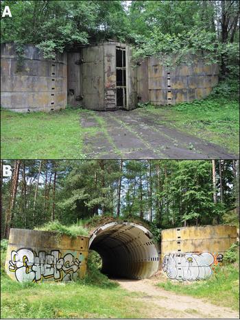
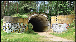
At the end of the 1970s, new structures were built within the nuclear storage zones at each of the three bases. These are Granit objects—single-storey bunkers constructed of prefabricated concrete elements and covered by a thick layer of earth (Figure 7). These were relatively simple buildings, with two gates at opposite ends (one at each end), and were built at many bases and military airfields in most other Warsaw Pact countries. The Granit design, along with advances in military technology, permitted safer storage and quicker access to the warheads. After the construction of the Granit, the nuclear storage zone was fortified, and a new line of trenches was dug inside the base for the protection of all three nuclear bunkers (Figure 5D). This may represent one of the final modifications in the field defences.
Granit bunkers: A) Podborsko; B) Brzeźnica Kolonia, with modern graffiti (photographs by G. Kiarszys).

For over two decades, the base at Podborsko was heavily guarded, and the soldiers’ activities there have left many material traces in the surrounding landscape. A notable feature recorded by ALS is the countless paths eroded by soldiers patrolling day after day (Figure 8A). Another feature related to everyday life can be seen at Brzeźnica Kolonia, where a full-sized football pitch, surrounded by a running track, was constructed during the 1980s (Figure 8B). This facility is extraordinary, as it was located in the middle of a vast forested area, many kilometres from the nearest towns and villages. After all the efforts made to keep the location of the base secret, such a decision seems not very astute, at least from a military perspective. A football pitch in the middle of the forest certainly drew the attention of NATO and CIA aerial photograph interpreters. The earliest satellite image (known to the author) showing these features appeared on images taken by the civilian Landsat satellite programme in 1984.
A) Patrol paths recorded by ALS (ALS derivative-positive openness (e.g. Doneus Reference Doneus2013)); B) the remains of the football pitch and running track at Brzeźnica Kolonia, with the track still clearly visible around it (ALS derivative-sky view factor (e.g. Zakšek et al. Reference Zakšek, Kokalj and Oštir2011)) (figure by G. Kiarszys).

The pattern of transformation presented above is very similar at each base, with few exceptions, suggesting that most of the construction activities were planned and ordered by the Soviet leadership. There are some minor differences detected by archaeological prospection.
Soviet nuclear storage sites seen from space
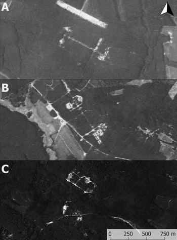
From the early 1960s, US intelligence spy satellites began systematic documentation of Warsaw Pact territories, and the Soviet nuclear bases were registered by the Corona and HEXAGON missions. Now declassified, the data are available—with some restriction—in the National Archives and Records Administration (NARA) in Washington, D.C. (e.g. Fowler Reference Fowler2003, Reference Fowler2004, Reference Fowler2005, Reference Fowler2008, Reference Fowler, Cowley, Standring and Abicht2010, Reference Fowler, Hanson and Oltean2013). The satellite images in Figure 9 show that all three nuclear bases were relatively easy to identify from space, despite the use of camouflage and vegetation cover. The Monolit bunkers are clearly visible, as are the overbuild areas and main roads. The images were captured in 1969, before the Granit objects at each base were built. The tree canopy obscures any vehicle shelters and ground defences. The satellite images are useful in that they can both confirm historical documents and provide insight into the technology available to NATO and the CIA at the time.
Declassified US spy satellite images of the Soviet nuclear bases at: A) Podborsko; B) Brzeźnica Kolonia; and C) Templewo. Images A–B come from Corona J-3, KH-4B, acquisition date 28 July 1969; image C comes from Corona J-3, KH-4B, acquisition date 27 July 1969. Data available from the US Geological Survey, EROS Data Center, Sioux Falls, SD, USA.

It should be kept in mind, however, that although some military structures were recorded using satellite imagery, it does not necessarily mean that the CIA photograph interpreters correctly recognised their function. There are no known reports that confirm if and how the structures were interpreted up to the end of the 1970s.
Did the ‘Enemy’ know? A small part of a larger puzzle
The passing of time since the end of the Cold War has brought increasing access to materials that give insight into NATO's perspective on the conflict. Some of the historical records regarding the presence of Soviet nuclear tactical forces in Eastern Europe can be accessed through the Central Intelligence Agency Records Search Tool (e.g. Fowler Reference Fowler2008). Almost all of these sources, however, are partially censored, with geographic names and maps frequently redacted.
One of the more revealing documents in this regard is a 1979 annual report entitled ‘Warsaw Pact Forces Opposite NATO’ (CIA 1979a). It seems to have been less carefully censored than other papers and contains more details than any prior or later documents (e.g. CIA 1975a: 23, 1975b, 1979b: 44–49, 1981: 20–23). The report contains a short description of the tactical nuclear forces in Eastern Europe and a map entitled ‘Soviet nuclear storage sites in Eastern Europe’ (Figure 10) (CIA 1979a: 45). Three places in Poland described on the map as ‘Nuclear warhead storage sites’ match the geographic locations of the military installations presented in this article. There are also four further places in western Poland referred to as ‘nuclear bomb storage sites’ and ‘temporary storage sites’. These can be identified as Soviet military airfields in Stargard-Kluczewo, Chojna and Wiechlice, along with a military base in Pstrąże. The presence of Granit bunkers at the two airfields is probably why the CIA considered them ‘nuclear ready’. All such bunkers were located some distance from the nearby airfields, within small, isolated security zones, although the Wiechlice airfield had a different type of associated nuclear storage site. This was a complex located approximately 1.5km to the south-east of the airfield, with a large concrete bunker of ‘Bazalt’ type constructed for storage purposes. The base at Pstrąże had three Granit bunkers. The report does not mention a military airfield in Bagicz, which also had a Granit bunker. This suggests that either the CIA did not know of its existence or that it was constructed after 1979.
The map from the declassified CIA report entitled ‘Warsaw Pact Forces Opposite NATO’, 31 January 1979 (CIA 1979a: 45).

NATO and the CIA undoubtedly knew the exact location and purpose of the main Soviet nuclear bases in Eastern Europe, at least from the 1970s. The 1979 report reveals that military nuclear facilities in Poland were just a small part of a much larger network, which spread from Bulgaria, through Hungary, Czechoslovakia and Poland, to East Germany. It was estimated that there were around 23 such installations in Eastern Europe, and at least some of them permanently housed nuclear weapons. Eleven were located at Soviet military airfields, and 12 were isolated storage sites (CIA 1979a: 45).
Conclusions
Until recently, the spatial organisation of the Soviet nuclear storage sites at Podborsko, Brzeźnica Kolonia and Templewo in western Poland was mostly unknown. Using an archaeological approach, it has been possible to create detailed maps of the complexes. Integration of ALS data and declassified satellite imagery also allows us to interpret change over time, and to relate these changes to archival documentation. In some aspects, the material remains of these installations present a very different image to that found in the documentary sources.
Archaeological studies of the Cold War period provide important new information with which we can re-interpret documentary sources, allowing for a more holistic understanding. Archaeology also provides an inspiring source of knowledge about some aspects of everyday life. Former Cold War military installations can be seen as ‘material witnesses’ through which we may attempt to understand aspects of Eastern Europe's difficult past, such as totalitarianism, cultural identity and ideological conflict.
The Cold War was a conflict that ignored national borders and spread all around the globe. It established a new order, dividing the world between hostile factions that, in most cases, overlay and replaced traditional cultural and national identities. Hence, archaeological studies of Cold War military sites in Poland should be considered in a much wider context. These studies may aid in the interpretation of other installations built according to similar rules throughout Eastern Europe. They also constitute material evidence of a period when the world was on the brink of nuclear war.
Although these sites are not yet protected by law, their meaning and value is gradually being recognised after many years of neglect. Recently, the former Soviet nuclear storage sites have attracted a growing number of tourists who want to experience the material remains of one of the best-guarded secrets of the Cold War in Eastern Europe. They are no longer just the remains of a totalitarian regime or relics of traumatic memories that should be erased. Instead, they speak to a contemporary identity shared throughout Eastern Europe. Archaeological perspectives offer insight into the past of these places, and allow us both to enrich their stories and to understand better the complexities of the present day.
Acknowledgements
The research was financed by the Ministry of Culture and National Heritage of the Republic of Poland.