1. Introduction
The three-dimensional shapes of igneous intrusions are often ambiguous, mainly because the floors are rarely exposed. Many granites and alkaline complexes that were originally considered thick plugs, batholithic, funnel shaped, ring dykes or cone sheets are being reinterpreted as (multiply inflated) sheet intrusions of more modest depth (e.g. Cruden, Reference Cruden1998; Wiebe & Collins, Reference Wiebe and Collins1998; O’Driscoll et al. Reference O’Driscoll, Troll, Reavy and Turner2006; Stevenson et al. Reference Stevenson, Owens, Hutton, Hood and Meighan2007; Magee et al. Reference Magee, Stevenson, O’Driscoll and Schofield2012). The Pilanesberg Complex is a large (625 km2) alkaline igneous complex with both volcanic and intrusive facies (summarized by Woolley, Reference Woolley2001) making it one of the largest (alkaline felsic rock-dominated) intrusions in the world, along with the Lovozero and Khibini in Russia (Kogarko et al. Reference Kogarko, Kononova, Orlova and Woolley1995), Poços de Caldas, Brazil (Thompson et al. Reference Thompson, Gibson, Mitchell, Dickin, Leonardos, Brod and Greenwood1998) and Kangerlussuaq, east Greenland (Riishuus et al. Reference Riishuus, Peate, Tegner, Wilson and Brooks2008). The current interpretation of the Pilanesberg Complex is a sub-vertical body of unspecified depth. The concentric outcrop pattern of the various felsic rock types in the Pilanesberg Complex makes it similar to these other intrusions, which are considered to be sheet-like. It is the intention here to examine the field relationships and hence possible emplacement geometry in light of recent investigations on emplacement mechanisms for other igneous bodies.
2. Geological setting
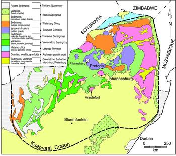
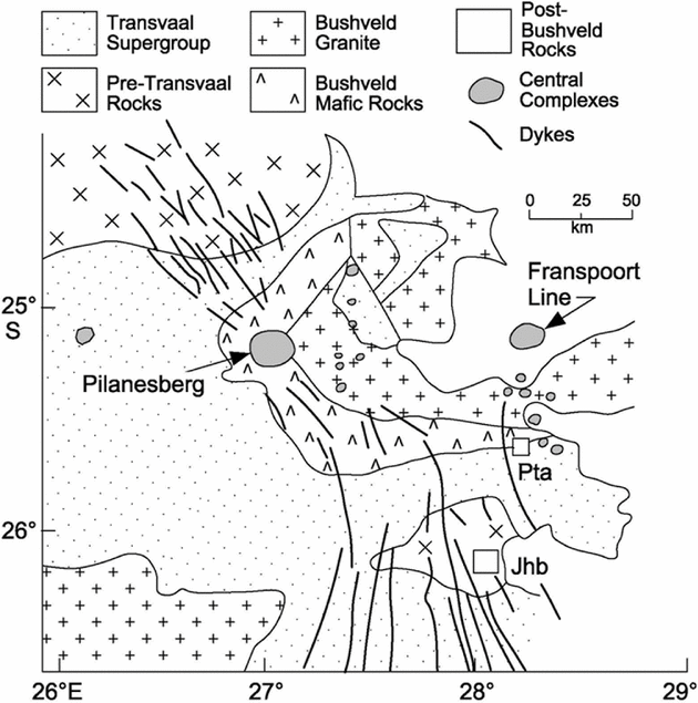
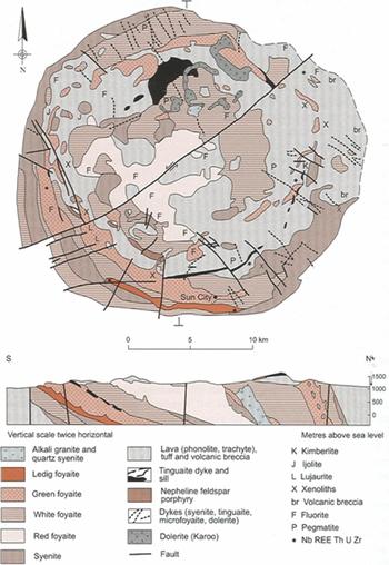
The Pilanesberg Complex was emplaced into the Kaapvaal craton of South Africa (Fig. 1), with intrusive contacts to the rocks of the Bushveld Complex (Fig. 2). It is part of a widespread igneous event referred to as the Pilanesberg Alkaline Province (Verwoerd, Reference Verwoerd, Johnson, Anhaeusser and Thomas2006), consisting of dykes, central volcanoes and circular intrusions. The presence of alkaline felsic lavas and the concentric nature of the nepheline-bearing intrusive rocks were identified by Molengraaff (Reference Molengraaff1906) and Humphrey (Reference Humphrey1912), respectively, but Shand (Reference Shand1928) made a major contribution, producing a map and petrographic descriptions. Subsequently, two theses (E. A. Retief, unpub. Ph.D. thesis, Univ. Oxford, 1963; J. Lurie, unpub. Ph.D. thesis, Rhodes Univ., 1973) were produced which included more detailed mapping. The geology of the complex is shown in Figure 3a, taken from the work of Lurie (unpub. Ph.D. thesis, Rhodes Univ., 1973).
Regional geological setting of the Kaapvaal craton, South Africa, showing the location of the Pilanesberg Complex.

Geological setting of the Pilanesberg Alkaline Province (adapted from Verwoerd, Reference Verwoerd, Johnson, Anhaeusser and Thomas2006), showing the location of the Pilanesberg Complex and its associated dyke swarm, and the Franspoort Line of alkaline complexes. Pta – Pretoria; Jhb – Johannesburg.

There are two reasons why little further work has been published on this body. First, there is very little definitive outcrop, the area being strewn with rubble (see Section 4), and so detailed geological interpretation is hampered. Second, these rocks have undergone extreme autometasomatism. For example, Mitchell & Liferovich (Reference Mitchell and Liferovich2006) listed in an appendix a bewildering assortment of secondary minerals identified in the Green Foyaite (nepheline syenite) facies (which is the youngest and freshest of the entire intrusion). Indeed, considerable effort has been expended on exploration for potential fluorite, thorium and rare-earth element mineralization (Lurie, Reference Lurie1979, Reference Lurie, Anhaeusser and Maske1986; Verwoerd, Reference Verwoerd, Anhaeusser and Maske1986), all of which are secondary deposits. (Exploration has been terminated because the Pilanesberg Complex now forms the central part of a National Park.)
Shand (Reference Shand1928, p. 148) suggested that the complex was a ‘laccolite with many roots’. Whether he implied exactly the same meaning in 1928 as laccolith now, namely a sheet with a planar bottom and convex top (Kearey, Reference Kearey1993), is unknown, but the essence would have been that it was a sub-planar sheet intruded below its own volcanic roof. Retief (unpub. Ph.D. thesis, Univ. Oxford, 1963) and Lurie (unpub. Ph.D. thesis, Rhodes Univ., 1973) proposed a very different shape. Retief envisaged a funnel shape. Lurie suggested that the intrusive rocks were ring dykes and cone sheets, and also that the entire complex had been tilted significantly.
Several attempts to determine the age of the complex have been presented. Dating of the associated dyke suite yielded ages of 1290 ± 180 Ma (Schreiner & Van Niekerk, Reference Schreiner and Van Niekerk1958) and 1330 ± 80 Ma (Van Niekerk, Reference Van Niekerk1962). K–Ar dating of biotite from the complex itself by Snelling (Reference Snelling1963) gave an age of 1250 ± 60 Ma. Whole-rock Rb–Sr analysis gave an age of 1193 ± 98 Ma (Harmer, Reference Harmer1999). The most recent figure is a value of 1397 ± 47 Ma by the U–Pb method on a grain of titanite by Harmer and Armstrong, but the details have yet to be fully published (Hanson et al. Reference Hanson, Harmer, Blenkinsop, Bullen, Dalziel, Gose, Hall, Kampunzu, Key, Mukwakwami, Munyanyiwa, Pancake, Seidel and Ward2006). The large age uncertainties, even using SHRIMP techniques, are further evidence that the rocks have undergone significant alteration. Hence, they are totally unrelated to the 2056 Ma Bushveld Complex.
3. Methods
Here I propose to examine the previous documentation of the field relationships, based on the published work of Shand (Reference Shand1928) and two unpublished theses by Retief (unpub. Ph.D. thesis, Univ. Oxford, 1963) and Lurie (unpub. Ph.D. thesis, Rhodes Univ., 1973). Summaries are contained in three other accessible reviews (Mathias, Reference Mathias, Fitton and Upton1987; Woolley, Reference Woolley2001; Verwoerd, Reference Verwoerd, Johnson, Anhaeusser and Thomas2006), but those authors provided no new information. A number of critical quotes are presented from those theses. I then add some further personal observations. General ideas on shapes of large igneous bodies and their mechanisms of emplacement have evolved since those early studies on the Pilanesberg Complex, and I propose to re-examine the assorted information in light of such interpretations. Finally, I present a two-dimensional Bouguer gravity anomaly model across the complex to qualitatively constrain the probable shape of this body. The geochemistry of these rocks will not be discussed.
Geological map (a) and cross-section (b) of the Pilanesberg Complex (after Lurie, unpub. Ph.D. thesis, Rhodes Univ., 1973; reproduced by Verwoerd, Reference Verwoerd, Johnson, Anhaeusser and Thomas2006, and included here with permission from the Geological Society of South Africa).

4. Previously presented field relationships
The following is a summary of the work and interpretations of Shand (Reference Shand1928), Retief (unpub. Ph.D. thesis, Univ. Oxford, 1963) and Lurie (unpub. Ph.D. thesis, Rhodes Univ., 1973).
There is a carapace of trachytic and phonolitic lavas that has been intruded by (and is coeval with) various syenitic and foyaitic (nepheline syenite) bodies and fine-grained dykes. There are a number of geographically discrete syenite and foyaite types, identified in the field and under the microscope, and mainly referred to by colour and/or by geographic location within the complex (e.g. Green Foyaite and Inner Red Syenite). The outcrop patterns of the intrusive rocks all demonstrate the concentric nature of the entire complex (Fig. 3a). The almost perfect circular nature presumably resulted from ring fracturing and cauldron subsidence. In more detail, the current view on the order of events, from oldest to youngest, is (Verwoerd, Reference Verwoerd, Johnson, Anhaeusser and Thomas2006):
-
1. Explosive volcanism (trachyte and phonolite)
-
2. Red Syenites (whether the Inner and Outer Red Syenites were coeval was not discussed)
-
3. More lavas and pyroclastic deposits
-
4. Red Foyaite
-
5. Further volcanic activity
-
6. White Foyaites (Inner and Outer White Foyaite, and possibly a third partial ring)
-
7. Green Foyaite and tinguaite (a porphyritic micro-foyaite)
-
8. Ledig Foyaite (possibly a variety of green foyaite with rosettes of aegirine and medium grained)
-
9. Alkali granite (a very minor rock type).
The strong implication is that each of the listed rock types is a discrete intrusive event. However, there are many aspects that challenge this inference. The following comments are taken from previous publications. Shand (Reference Shand1928, p. 102) noted, ‘The Pilanesberg proved to be a most unsatisfactory place to map. . .. Hills are draped with scree to such an extent that it is often impossible to decide what lies underneath the cover. . .. Mapping thus resolves itself largely to the interpretation of scree deposits.’ Lurie (unpub. Ph.D. thesis, Rhodes Univ., 1973) stated that ‘contact zones between the component units correspond largely with ring valleys and are thus covered by scree and soil’. Verwoerd (Reference Verwoerd, Johnson, Anhaeusser and Thomas2006, p. 383) reiterated the problem that ‘contacts between major rock types are seldom observed because they are located in alluvium-filled valleys or on scree-covered slopes’. These comments underlie the reasons for the lamentation by Mitchell & Liferovich (Reference Mitchell and Liferovich2006) that the complex is ‘as yet inadequately characterized’.
More specifically, in terms of the contacts between the Green and White Foyaites, Shand (Reference Shand1928, pp. 110–11) noted, ‘The difficulty that arises when one tries to separate the two types on the map is the perfectly gradual passage of one type into the other. . .. My idea [of where to place the boundary] varied according to whether I passed from the green rock towards the white or from the white towards the green.’ He did not state by how many metres there was such a gradation. Illustrating the problem further, Lurie (unpub. Ph.D. thesis, Rhodes Univ., 1973) stated that ‘While typical specimens of these two [Green and White] Foyaites are easily distinguished, difficulty in field recognition is experienced in some cases.’ He also stated (p. 112), ‘The relation of the tinguaite to the green foyaite is sometimes apparently intrusive and sometimes merely transitional, and there is often an alternation of fine-grained [tinguaitic] with more coarse-grained [foyaitic] facies.’
Other contacts create similar problems. Shand (Reference Shand1928, p. 116) stated, ‘The relation between the Red Syenite of the outer ring and the White Foyaite next to it is believed to be one of gradual transition,. . . Red Syenite becomes paler in colour, gradually developed a pitted surface (indicating the coming in of nepheline) . . . within a distance of one hundred to three hundred yards.’ This suggestion is borne out by the comments of Pantshi & Theart (Reference Pantshi and Theart2008), who chemically analysed many samples in a grid pattern (while evaluating the Al potential of these alkaline rocks for exploitation) from the outer Red Syenite, and concluded that ‘27 % may be classified as foyaite [based on normative mineral assemblage]. . . most probably represent the gradational variety between White Foyaite and Red Syenite’. Similarly, Lurie (unpub. Ph.D. thesis, Rhodes Univ., 1973, p. 39) referred to difficulties in drawing a boundary between White Foyaite and Ledig Foyaite and suggested that the latter may be a marginal phase of the former.
There are further problems in discriminating not only between the rock units, but also within a single unit, where there are suggestions of multiple subdivisions. Verwoerd (Reference Verwoerd, Johnson, Anhaeusser and Thomas2006, p. 383) stated that ‘the White and Green Foyaites are themselves composite’. Retief described several facies of the Green Foyaite, and because of its distinctive texture of radiating aegirine rosettes referred to one facies as the Ledig Foyaite. Mathias (Reference Mathias, Fitton and Upton1987, quoting Retief) referred to the White Foyaite as three separate ring dykes, again based on textural differences. However, Retief (unpub. Ph.D. thesis, Univ. Oxford, 1963) actually identified seven different textural varieties of the White Foyaite, but it is not clear if he implied that they were separate intrusions or not.
Perhaps these comments have been subjectively highlighted from within a large database of important field relationships documented by the three main map-makers of the Pilanesberg Complex. However, they do demonstrate the uncertainty and complexity of interpretation in an area of poor exposure.
5. New field observations
I have not remapped the complex, merely traversed many areas confirming the essence of the previous mapping, and noted the sad lack of crucial exposures to determine emplacement sequences and lithological orientations. A few definitive observations can be made concerning (first) the sequence of events listed in Section 4, and (second) the gross geometry of the rock types.
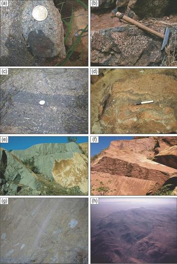
The number of discrete volcanic events cannot be resolved. No stratigraphy for the volcanic succession can be compiled owing to major gaps and dip changes between outcrops. In detail, blocks of lava occur within the central Red Syenite (Fig. 4a), and also blocks of Red Syenite occur within lavas (Fig. 4b). Hence, volcanicity straddles the emplacement and cooling of the Red Syenite body. Several fine-grained dykes cut most of the intrusive rocks except the Green Foyaite suite. Their compositions are similar to the range of lava compositions, and so if they are assumed to be feeders to those lavas the period of volcanicity must have been protracted. Rare, distinctive tinguaite dykes cut the volcanic succession and the Green Foyaite (Fig. 4c). They contain porphyritic, vertically aligned sanidine crystals in a fine- to medium-grained matrix of aegirine, nepheline and alkali feldspar. Previous authors have related these dykes to the Green Foyaite suite, and, if so, the Green Foyaite suite can be considered to have post-dated some of the volcanic rocks.
Assorted field photographs. (a) lava block in syenite (note feldspar phenocrysts growing into margin of block; coin for scale is 2.5 cm in diameter; (b) syenite block in lava; hammer for scale is 35 cm long; (c) multiple (sub-vertical) intrusions in the Green Foyaite on a horizontal surface; coin for scale is 2.5 cm diameter; (d) irregular, convoluted, near-vertical layering of aegirine-rich Green Foyaite; pen for scale is 15 cm long; (e) homogeneous, vertical quarry face of Outer White Foyaite (6 m high); (f) quarried Red Syenite (4 m high); (g) single faint mafic layer in quarry of White Foyaite. The faint nearly vertical pale zones are water stain marks (1.5 m high); (h) oblique aerial view of southwest portion of complex showing an inward-dipping structure in Outer White Foyaite (about 4 km wide).

For the coarse-grained intrusive rocks, demonstrating any age relationships is essentially impossible. No cross-cutting relationships exist, the different facies are orientated conformably to each other, often having at best gradational contacts, and more often there is no crucial exposure (as described in Section 4 by the previous workers).
Evidence for the three-dimensional shape of this complex is even more elusive. Individual lavas flows are hard to identify and their dips are usually best inferred by viewing at a distance of more than 1 km. Reported dips are variable (Fig. 3a), and it appears that the volcanic succession now constitutes dislocated blocks that have collapsed into a caldera, and primary dips may not have been preserved. Present dips shown on the maps of Lurie and Retief define a pattern generally inward dipping at angles of up to 50°. The intrusive rocks are generally homogeneous. Mineral layering is extremely rare and fabrics are not traceable laterally. The Green Foyaite suite is the only suite that shows (rare) mineral layering. Very close to the outer contact of the intrusion, aegirine-rich layers are steeply dipping (Fig. 4d). Similar aegirine-rich occurrences near the middle of the complex have a foliation (as opposed to modal layering), but lateral continuity cannot be traced far (as noted by Mitchell & Liferovich, Reference Mitchell and Liferovich2006).
The Outer White Foyaite and Inner Red Syenite were briefly quarried for polished dimension stone, and so large, perfectly fresh surfaces in various orientations are available for inspection (Fig. 4e, f). In only one instance was a faint gentle synclinal more mafic layer identified (Fig. 4g), dipping at a shallow angle towards the centre of the complex. A more spectacular structure is evident in an oblique air photograph of the White Foyaite arc in the southwest of the complex (Fig. 4h). It shows a structure gently dipping inwards. However, in the field no modal layering or fabric can be recognized and so it cannot be proven exactly what this structure represents.
The country rocks to the complex provide further information about the shape of this body. Lurie (unpub. Ph.D. thesis, Rhodes Univ., 1973) suggested that the complex had been tilted (upwards to the south). Such a rotation would have affected the country rocks. The country rocks to the Pilanesberg Complex are the mafic layered rocks of the Bushveld Complex for most of the perimeter. Immediately south of the Pilanesberg Complex they dip gently northeast and to the north they dip gently southeast, as part of a broad syncline. Although exposure of these rocks is poor, considerable exploration drilling for platinum in the Merensky Reef has been undertaken, and new mines opened, ever progressively nearer to the Pilanesberg Complex (both from the north and south), and no major change in dips or disruptions of this Reef has been observed.
6. Re-interpretation of the shape of the complex
The three-dimensional interpretation of the shape of the complex shown in Figure 3b (from Lurie, unpub. Ph.D. thesis, Rhodes Univ., 1973) is based on very little geometrical evidence, and a conformism to the then held views on ring dykes and cone sheets. I re-examine both of those concepts here.
As regards the contacts between intrusive rock units, they are often gradational (as quoted in Section 4). Lurie (unpub. Ph.D. thesis, Rhodes Univ., 1973) noted that the attitudes of individual bodies could only be determined from aerial photographical interpretation, specifically in the northeast, rather than in outcrop in the field. He suggested that the intrusive bodies dip inwards in the south and outwards in the north and attributed this relationship to a subsequent southward tilting of an originally symmetrical funnel shape of Retief (unpub. Ph.D. thesis, Univ. Oxford, 1963). Lurie's map (Fig. 3a) shows dip arrows to this effect, but does not include any angles of dip.
The cross-section in Figure 3b from Lurie (unpub. Ph.D. thesis, Rhodes Univ., 1973) shows very steep sides to the body in the north. Given its 25 km diameter, extrapolation of this geometrical shape downwards would reach unrealistic depths, and so must be questioned. Further, the interpretation of tilting is not consistent with certain observations, both internal and external to the Pilanesberg Complex. If southward tilting had occurred, the volcanic succession, forming the upper part of this complex, would be more likely to be preserved in the south than in the north, whereas the exact reverse is the case (Fig. 3a). Also, the general (somewhat erratic) symmetry of inward-dipping volcanic rocks would not have been preserved. Dips would be steeper in the northeast and gentler (or even outward dipping) in the southwest. Again this is not observed (Fig. 3a). There is some faulting, but that is to be expected where a 25 km diameter igneous body has been emplaced, but regional dips external to the complex survive. It would not be possible for the Pilanesberg Complex to have been significantly tilted without tilting and deformation of these surrounding (Bushveld) rocks, which is not supported by their regional dip directions.
Mathias (Reference Mathias, Fitton and Upton1987, p. 195, quoting Retief) suggested that the White Foyaite represented ‘three ring dykes and not a single intrusion, separated by later Green Foyaite’. According to this model, the outer two White Foyaite sheets are considered to be different intrusions. The later Green Foyaite would then have to have been emplaced along the contact between these two ring dykes over large distances. Such a fortuitous emplacement appears unlikely.
I suggest a slight revision to the geometrical model presented by Shand (Reference Shand1928). The inward dip of the volcanic rocks provides the first clue. If the volcanic rocks have collapsed inwards, so presumably have the underlying intrusive rocks (to varying extents). Such a relationship suggests that the present outcrop pattern of both extrusive and intrusive rocks is the result of this collapse, rather than being a primary feature.
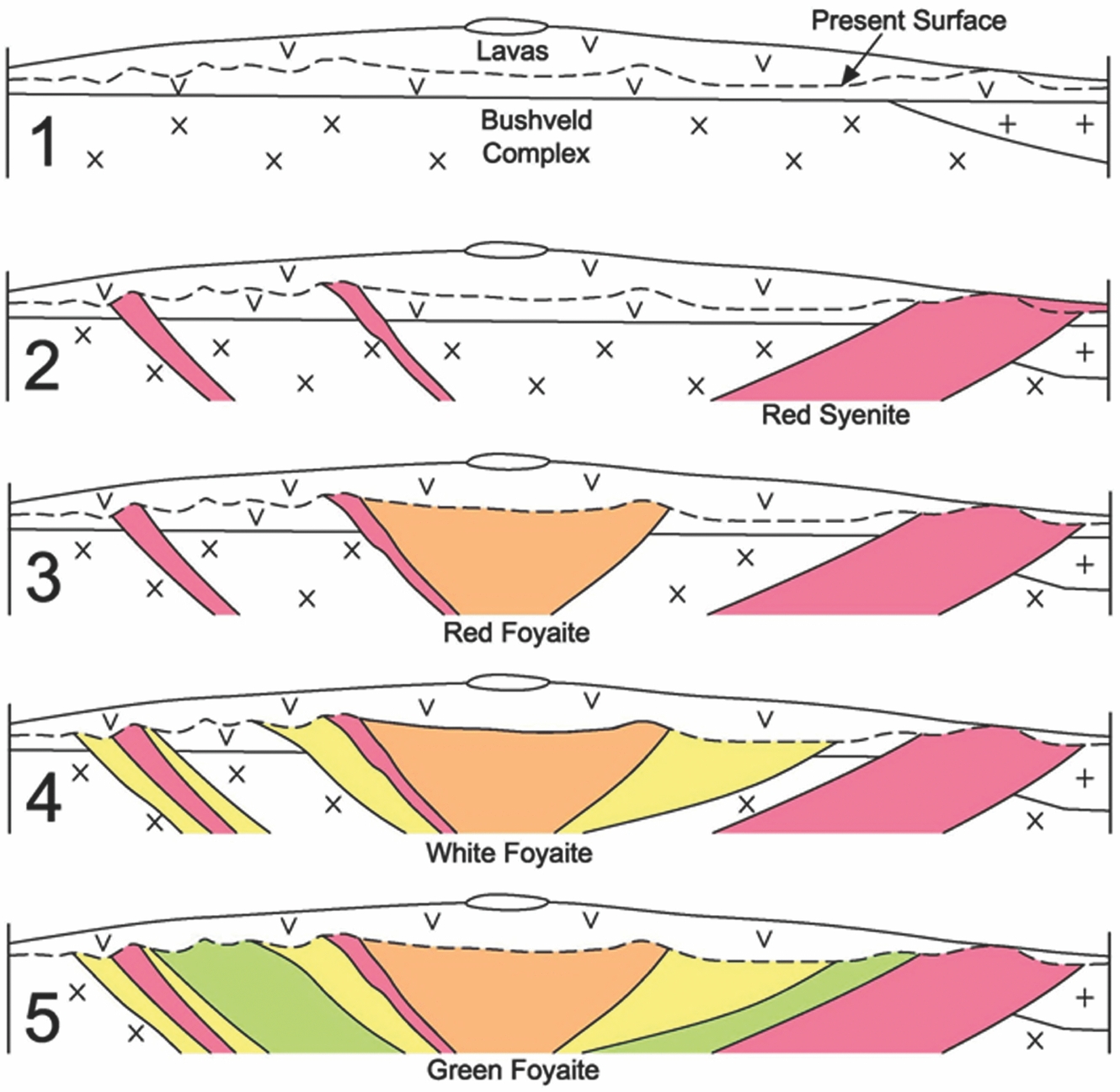
In the model of Lurie (unpub. Ph.D. thesis, Rhodes Univ., 1973) the oldest intrusive rock unit is considered to be the Inner Red Syenite that occurs as disrupted remnants in the middle in plan view (Fig. 3a). The Red Foyaite then intruded into the inner portion of the Red Syenite. Each subsequent younger intrusion was inferred to have been emplaced around the previous, ever-enlarging, body in plan view. Finally, there is the timing and location of the Outer Red Syenite and it is not clear in the previous interpretations whether it is considered coeval with the Inner Red Syenite or represents the last intrusive event (being on the outside). Such an overall structural evolution is very difficult to conceive in relation to the space and volume problem and mechanism of emplacement. Assuming a funnel-shaped model, a fairly small body of (Inner) Red Syenite would have been emplaced first, together with a more substantial body of (Outer) Red Syenite (Fig. 5; cross-section number 2). It is then not clear how the immediate country rock between the two Red Syenites (which would have been mafic Bushveld rocks) could have been displaced to make space for each subsequent intrusion (totalling 10 km radially). The injection of the Red Foyaite (cross-section 3), the White Foyaites (cross-section 4) and the Green Foyaite (cross-section 5) follow in the model of Lurie (unpub. Ph.D. thesis, Rhodes Univ., 1973), but the fate of the pre-existing country rock is not obvious. The country rock cannot have been pushed outwards to create space, because the Outer Red Syenite is already in place, and there is no evidence of deformation in the Bushveld rocks. The classic cone sheet displacement model (as implied by Fig. 3b) would require enormous uplift of the pre-existing rocks, which would have been the (Inner) Red Syenite and the volcanic rocks, to create space for each of the White Foyaites. This uplift must have been repeated with each intrusion of younger foyaites. Given multiple uplift, it is hard to envisage how the first-formed rocks, namely the volcanic pile, could have been preserved. It is also noted that classic cone sheets are typically no more than a few metres thick and are usually fine to medium grained. The alleged cone sheet units here are extremely thick (kilometres wide in outcrop) and uniformly coarse grained.
Model of sequential emplacement of cone sheets as proposed by Lurie (unpub. Ph.D. thesis, Rhodes Univ., 1973) along a W–E section through the centre of the complex. The emplacement order is as proposed by Lurie. Section 1 shows the relationships after (some) volcanic rocks had been erupted. Section 2 shows the emplacement of the Inner and Outer Red Foyaites, followed by Red Foyaite (Section 3), White Foyaites (Section 4) and Green Foyaite (Section 5). The country rocks are generally the mafic rocks (shown as crosses) of the Bushveld Complex, with the associated granites (shown by plus signs) occurring to the east.

The alternative mechanism for creating space is via ring dykes, where the central block sinks. Again, typical ring dykes are relatively thin and do not have the radial width on the surface seen for the units in the Pilanesberg Complex. For example, the outcrop widths of each of the three White Foyaite rings are typically in excess of 1 km, which is not possible for a ring dyke unless the downward displacement of the ‘foundered block inside had subsided to quite impossible depths’ (Holmes, Reference Holmes1965, p. 261).
Lateral displacement of the pre-existing country rock is equally unlikely. Stevenson et al. (Reference Stevenson, Owens, Hutton, Hood and Meighan2007) debated the validity of the ring-dyke concept by showing that deformation of the surrounding country rocks was required to create space (even for relatively much smaller bodies than the Pilanesberg Complex). As shown by exploration and mining activities of the surrounding mafic Bushveld Complex rocks, no significant deformation exists.
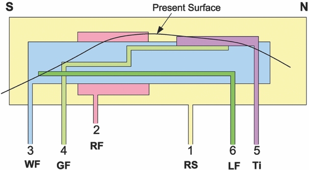
An alternative interpretation of the shape and emplacement of the Ardnamurchan body has been developed by O’Driscoll et al. (Reference O’Driscoll, Troll, Reavy and Turner2006), and I lean heavily on those views in re-interpreting the structure of the Pilanesberg Complex. I speculate that the emplacement was more of a sub-horizontal sheet-like nature, and that subsequent sagging caused the present surface relationships. Other examples where there is evidence for a sheet-like emplacement rather than a plug-like geometry are noted by Corry (Reference Corry1988), Cruden (Reference Cruden1998) and Wiebe & Collins (Reference Wiebe and Collins1998) for granites and by Henderson, Pendlebury & Foland (Reference Henderson, Pendlebury and Foland1989) and Launeau & Cruden (Reference Launeau and Cruden1998) for syenites. Such relationships are shown in Figure 6. It has many similarities with the Kangerlussuaq Intrusion in Greenland, which was first described as a single intrusion by Wager & Brown (Reference Wager and Brown1969), but is now considered to have formed by multiple pulses of magma while the centre of the sheet was still partially molten (Riishuus et al. Reference Riishuus, Peate, Tegner, Wilson and Brooks2008). There is one difference, namely that the upper contact relationships are not preserved for the Kangerlussuaq Intrusion, whereas in this model for the Pilanesberg Complex I suggest that they are. The Lovozero complex (650 km2), consisting of variably feldspathoidal syenites with a concentric outcrop pattern, is also considered to comprise nested sheets and sill-like bodies producing an overall lopolithic shape some 2 km thick (Kogarko et al. Reference Kogarko, Kononova, Orlova and Woolley1995). The orientation of modal layering in this body provides strong support for this shape and mechanism.
Alternative model for emplacement of the intrusive rocks as flat sheets and vertical feeders. Subsequently the entire body subsided inwards, and this is schematically illustrated by showing the current surface as a convex curved line. The order of emplacement is: 0 – Volcanic rocks, 1 – Red Syenite, 2 – Red Foyaite, 3 – White Foyaite, 4 – Green Foyaite, 5 – Tinguaite, 6 – Ledig Foyaite. However, previous injections need not have been entirely solid prior to subsequent injections of magma.

7. Order of emplacement
For the Pilanesberg Complex, I suggest that (some of) the volcanic sequence developed first. Into it was emplaced a sheet-like body of magma that would become the Red Syenites (Fig. 6). Subsequent multiple injections of foyaitic magma occurred into the centre of the incompletely crystalline syenite, inflating the magma chamber vertically. The two Red Syenites (Inner and Outer) represent the marginal roof and the floor facies of a single magmatic event in this model. Such a model explains the distribution of the syenite both near the centre and at the edge of the Pilanesberg Complex. Three possibilities then exist for the White Foyaites. (1) The magma that produced the White Foyaites may then have been emplaced into solid Red Syenite. (2) The magma may have been emplaced into the still liquid central portion of the Red Syenite. (3) The Red Syenite represents the marginal facies of a contaminated portion of pristine magma that was silica undersaturated (White Foyaite). Inward crystallization produced the inferred gradual transition from syenite to foyaite as stated by Shand (Reference Shand1928) and inferred from the geochemical data of Pantshi & Theart (Reference Pantshi and Theart2008) referred to in Section 4. A model analogous to (1) was proposed by Brotzu et al. (Reference Brotzu, Gomes, Melluso, Morbelli, Morra and Ruberti1997) for the Itatiaia intrusion (of comparable dimension to Pilanesberg) in Brazil, based on clearly cross-cutting relationships and intrusion breccias. Such features are absent in the Pilanesberg Complex, and so I prefer some combination of models 2 and 3, emphasizing the possible similarity with the Kangerlussuaq Intrusion (Riishuus et al. Reference Riishuus, Peate, Tegner, Wilson and Brooks2008). The Red Syenites may represent the earliest pulses of contaminated magma, rapidly followed by uncontaminated foyaitic magma. The last event, the Green (and Ledig) Foyaite, may represent either the residuum of fractionation or addition of further (highly evolved) magma.
Finally, as this sheet of magma solidified central subsidence caused it to form a gentle dish shape such that the lowest rocks crop out as a peripheral ring and the upper facies as a central mass, even though both are of the same age. Thus, the Outer and Inner Red Syenites should be renamed the Lower and Upper Red Syenites. One of the reasons for considering the Inner Red Syenite as a roof facies is because of it being the most intensely altered of all the rock types, a feature common to even the youngest of the intrusive rocks (Mitchell & Liferovich, Reference Mitchell and Liferovich2006). This feature could be explained as the result of upward fluid escape from the centre of the solidifying sheet. I suggest that this geometry and sequence of emplacement is consistent with all the observations and field relationships listed above. It minimizes the problems of displacement of pre-existing Bushveld rocks in the ring-dyke/cone-sheet model.
8. Gravity model
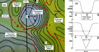
The Council for Geoscience, Pretoria, has produced a regional Bouguer gravity map for South Africa (Council for Geoscience, 1997) at a scale of 1:1 000 000, contoured at 10 mGal intervals. For the area including and immediately surrounding the Pilanesberg Complex the superimposed geology and gravity data are shown in Figure 7. The mafic rocks of the Bushveld have an overall density of 3.1 g.cm−3, whereas the Pilanesberg syenites and volcanic rocks have a density of 2.7 g.cm−3 (Maré, Reference Maré2011). This large density contrast enables the modelling of the gravity data with some degree of confidence. The first important feature to note in Figure 7 is that the gravity low is offset from the centre of outcrop of the Pilanesberg Complex towards the west. This offset to the west is owing to the fact that the mafic rocks of the Bushveld Complex dip at about 13° from west to east. Hence, at the western edge of the Pilanesberg Complex the underlying mafic rocks are quite thin, whereas in the east they are much thicker (possibly 7 km). This imposes a significant regional gravity gradient, increasing to the east. Superimposing rocks with a perfectly symmetrical gravity low due to the Pilanesberg Complex onto this gradient results in an apparent displacement of the gravity low to the west of its true geographic centre.
(a) Bouguer gravity map and (b) proposed model for the cross-sectional shape of the Pilanesberg Complex. The colour-contoured gravity map is a small portion taken from the gravity map of South Africa produced by the Council for Geoscience (1997), South Africa. The section is approximately N–S so that it is parallel to the strike of the rocks of the Bushveld Complex. A density contrast of 0.4 g.cm−3 between the alkaline complex and the mafic rocks is used in the calculations. There is no single linear array of measured gravity stations in this direction and so no actual measured points can be shown, but the coloured map and contour lines represent the model from the two-dimensional data array produced by the Council for Geoscience, South Africa.

The second important feature is that the gravity contours define steep gradients to the north, south and east, but then display a large area of near-constant gravity values, not decreasing below the −150 mGal contour near the centre of the complex. These data have been modelled using a 2.5 dimensional computer program (written by Gordon Cooper, University of the Witwatersrand, and available at http://www/wits.ac.za/science/geophysics/software.htm) along the line A–O–B in Figure 7. This line was chosen to be parallel to the strike of the mafic rocks of the Bushveld Complex and so it can be assumed that the Bushveld rocks have a constant thickness along this line. Two models are presented. One assumes a nearly flat sheet, and the other a funnel shape. Models cannot be assumed to be definitive, but the flat sheet model gives a flat bottom to the gravity profile comparable to that seen in the data, whereas the funnel-shaped model produces a narrower minimum. In the funnel model, gravity values decrease to more than −10 mGal below this reference line, which is not seen in the contour lines of the Council for Geoscience published map. Thus, the sheet model appears more consistent with the gravity data than the funnel model.
9. Summary
The Pilanesberg Complex is a large, circular body of alkaline volcanic and intrusive rocks in South Africa. Its shape in the third dimension is purely speculative because there is no systematic modal layering and orientations of contacts of the intrusive rocks cannot be identified in the field. The earliest interpretation was as a laccolith, which was superseded by the suggestion that it was funnel shaped (that had been subsequently tilted). In this second model it is difficult to understand to where the pre-existing rocks had been displaced, and how such a funnel shape could have been tilted. A simple interpretation of the Bouguer gravity data suggests that a relatively flat sheet rather than steep-sided, deeply rooted lower contact is more probable. The present suggestion is that it is lopolithic, with possibly multiple magmas feeding into the centre of a still partially liquid sheet, rather than into solidified, steeply dipping earlier intrusive phases.
Acknowledgements
Funding from NRF (South Africa) is greatly appreciated. Morten Riishuus, Brian O’Driscoll and Phil Peat provided many valuable and constructive suggestions on this manuscript.