1. Introduction
Unmanned surface vessels (USVs) are intelligent-motion platforms that can navigate safely and autonomously in an actual marine environment and are used to complete various tasks because of their mobility and economic efficiency (Zhu et al., Reference Zhu, Shen, Wang, Jia and Zhang2021a). They can be regarded as a typical multi-sensor system that comprises global positioning system (GPS) functionality and strap-down inertial navigation system (SINS) in an integrated framework. USVs can conduct marine investigations and accurate surveys such as marine surveying and engineering mapping, sedimentary facies study, water emergency rescue, and coastline patrol. Compared with other vessels, they have low maintenance costs, and the absence of crew on board is an advantage. When USV is used alone, there are problems such as the environment relying on precision and outliers (Xu and Xu, Reference Xu and Xu2017). However, high-precision sensors have been installed for a while to mitigate these problems.
SINS is an important part of an autonomous system; it obtains the position, speed, and azimuth information using the real angle velocity. This is measured using gyroscopes and specific force derived from accelerometers (Doostdar et al., Reference Doostdar, Keighobadi and Hamed2019). The error of navigation output produced by the SINS accumulates with time, however, due to the combined effects of the higher update rate and noise of the inertial measurement unit (IMU), which deteriorates the navigation solution. Therefore, it is necessary to employ an auxiliary sensor to reduce this error, particularly for USV operations. This demand can be met using GPS receiver technology, which provides continuous and high-precision positioning information covering the entire world at all times of day and night. This is te basis for the SINS/GPS integrated navigation system.
As shown in Figure 1, the SINS/GPS integrated navigation system is easily affected by GPS signal blockage or signal attenuation, thus reducing the positioning accuracy. The problem of GPS unavailability is addressed from two aspects in recent literature. First, increase the number or enrich the type of external sensors (Abdel-Hafez et al., Reference Abdel-Hafez, Saad Edd In and Jarrah2015; Li et al., Reference Li, Chang, Gao, Jian and Hernandez2016; Han et al., Reference Han, Wang and Mingyi2018; Mu et al., Reference Mu, He, Wu, Zhang and Yan2020; Zhu et al., Reference Zhu, Ma, Li, Malekian and Sotelon2021b). Second, use algorithm isolation and alternative approaches, including Kalman filter (KF) (Lin et al., Reference Lin, Qiu and Feng2015), federated filter (Wang et al., Reference Wang, Cui, Li and Ye2017), particle filter (Zhang et al., Reference Zhang, Guo and Zhang2018), support vector machine (SVM) algorithm (Xu et al., Reference Xu, Li, Rizos and Xu2010), and artificial neural networks (ANN) (Li et al., Reference Li, Song, Yang, Li and Cai2017). Although the problem of GPS outages can be solved by increasing the number or types of external sensors, additional sensors lead to higher costs and poor autonomy. Therefore, this study uses algorithms to realise information prediction when a GPS signal is lost.
Curve of GPS position error

The integration of SINS and GPS can fully use the advantages of these two sensors to ensure superior performance to any single sensor. For the SINS/GPS integrated navigation system, the method most frequently used to obtain the navigation solution is the KF-based method, such as cubature KF (Chen et al., Reference Chen, Yin, Zhou, Wang, Wang and Chen2018; Shen et al., Reference Shen, Zhang, Tang, Cao and Liu2019), unscented KF (UKF) (Tan et al., Reference Tan, Wang and Zhao2015) and robust KF (RKF) (Aslinezhad et al., Reference Aslinezhad, Malekijavan and Abbasi2020). However, the main limitation of the KF-based method is that it requires the stochastic modelling of sensor errors and precise prior information of the noise covariance matrix related to SINS and GPS. To enhance the prediction accuracy of a tightly coupled navigation system of global navigation satellite system (GNSS) and inertial navigation system (INS), a new progressive Gaussian approximate filter algorithm based on the variable step size and adaptive measurement noise covariance matrix is proposed (Bai et al., Reference Bai, Huang, Chen and Zhang2021a). However, that method is unsuitable because the measurement noise has a non-Gaussian distribution. Some researchers have recently used the particle filter method (Georgy et al., Reference Georgy, Karamat, Iqbal and Noureldin2011) to conquer these shortcomings of the KF-based method and defined a set of stochastic particles to describe the posterior distribution. An innovative normal skew mixed distribution is built using the proposed Bernoulli distribution random variables while a new robust KF method considering the normal skew mixed distribution is proposed using the variational Bayesian approach (Bai et al., Reference Bai, Huang, Chen and Zhang2021a). GNSS/INS integrated navigation systems are processed and analysed using the GINav platform (Chen et al., Reference Chen, Chang and Chen2021). An innovative autonomous unmanned system concept is developed for monitoring the water depth of shallow water bodies. Autonomous unmanned aerial vehicles and ground vehicles are used to research the seabed topography of the coastal zone (Specht et al., Reference Specht, Stateczny, Specht, Widźgowski, Lewicka and Wiśniewska2021). The applicability of GNSS/INS in hydrological measurement has been deeply studied (Stateczny et al., Reference Stateczny, Specht, Specht, Brčić, Jugović, Widźgowski, Wiśniewska and Lewicka2021). However, the proposed method does not consider bad sea conditions. A new robust KF method considering heavy-tailed mixture distribution was presented for underwater vehicles, and good results were obtained (Bai et al., Reference Bai, Huang, Zhang and Chen2021b). The particle filter method requires many particles, which significantly increases the computational cost of this method. The least squares SVM (LS-SVM) algorithm was applied to enhance indoor mobile robots’ navigation and acquire favourable results. When computing the navigation solution, the demand for computing time and storage space was higher with the increase in the dimension of the state matrices (Chen et al., Reference Chen, Xu, Li, Tan and Shen2016). Therefore, this method cannot suffice for the needs of ship navigation. The proposed adaptive neuro-fuzzy inference system method is used in the real-time realisation of INS/GPS integration (Sharaf et al., Reference Sharaf, Tarbouchi, El-Shafie and Noureldin2005). The system's delay time is excessively long due to the increased computing and learning time, making it unsuitable for ship navigation.
Currently, neural network-based technology such as ANN (Chiang and Huang, 2008), wavelet neural network (Jain and Singh, Reference Jain and Singh2013), radial basis function neural network (He et al., Reference He, Luo, Lee, Zhang, Cao and Lu2018) and multi-layer perceptron neural network (Ng, Reference Ng2016) is a popular research topic. The ANN framework (Fang et al., Reference Fang, Yin and Lei2015) is designed to dominate the gyro stabilisation platform, while navigation error is reduced to varying degrees. However, training the network parameters to estimate state measurements often takes a long time due to its complex implementation. Additionally, the trained network parameters should be used to learn the relationship between input and output for SINS/GPS integration, and large-scale training data should be provided to achieve high performance (Noureldin et al., Reference Noureldin, El-Shafie and Bayoumi2011). Considering much data is provided, training a neural network requires a lot of time. Moreover, the specific force and angular velocity given by the IMU can be used in inputting part of the ANN framework to compute GPS position error (El-Sheimy et al., Reference El-Sheimy, Chiang and Noureldin2006). One key advantage is that the network is uncomplicated and apt for implementation, but the model is subject to limitations. Speed and attitude information are also used as the model's input to achieve a better estimated value. From the aspect of the complex degree of the model, this input information increases the complexity, and the ANN-based approach influences the efficiency of prediction due to insufficient information on the pre-filtering of IMU data.
This study uses an innovative combination of Dempster–Shafer (DS) and broad learning (BL) theories in the SINS/GPS integration module. The first process is the realisation of model training. Under the condition that a GPS signal is available, the velocity and position information derived from SINS and their corresponding GPS are fused using DS fusion rules. The fused high-precision velocity and position data, as well as the velocity and position data derived from the SINS, are used as the input for the BL network. This step is called the training process, where the BL framework implements the learning and training of sensor information. The errors of velocity and position of SINS are selected as the BL output. The prediction of GPS is the second process. The trained BL framework estimates the velocity and position data according to the velocity and position information derived from the SINS in case of a GPS outage to replace GPS output, which is referred to as the virtual GPS. One significant advantage of using DS and BL for USV is that the ignorant states are not assigned a weight, whereas the unknown states are assigned to the remaining weights. The main contributions of this paper are outlined as follows:
(1) This study presents an innovative combination of DS and BL theory to address the challenge that uncertain perceptual information provided by INS and GPS cannot be effectively fused in USVs.
(2) Unlike the Bayesian technique, it is shown that the event occurrence probability does not constrain the abnormal or normal state. Meanwhile, even if evidence data fusion is implemented, it is not subject to prior knowledge of probability distributions.
(3) To validate the effectiveness of the proposed method, the sea trajectory of a USV is compared with other existing state-of-the-art methods.
The rest of this paper is organised as follows. Section 2 describes the DS theory and standard BL algorithm. Section 3 presents the SINS/GPS integration framework and the DS–BL method. The simulation and sea trial of USV is designed, and experimental results are analysed in Section 4. Finally, Section 5 presents the concluding remarks.
2. Problem descriptions
2.1 DS theory
The DS evidence theory is a data decision-level fusion method. It can directly indicate the ‘uncertain’ and ‘unknown’ information, expressed in the basic probability distribution function and retained in evidence synthesis. Evidence theory makes it possible to give credibility to a single element of the hypothesis space and its subset and uses the trust interval to quantify the credibility of the evidence. Hence, the DS evidence theory can solve the problem of multi-level and multi-source data fusion without knowing the prior probability. A mathematician at Harvard University in the United States, A.P. Dempster, proposed the trust and likelihood functions (Petturiti and Vantaggi, Reference Petturiti and Vantaggi2017). Shafer (Aggarwal et al., Reference Aggarwal, Bhatt, Devabhaktuni and Bhattacharya2013) further studied evidence theory to handle uncertainty problems.
In the DS framework, let Θ be a frame of discernment, Θ = {θ 1, θ 2, ⋅ ⋅ ⋅ , θN}. Basic probability assignment (BPA) is defined as a real-valued function m, which maps from 2Θ to [0, 1], called a mass function (Zhou et al., Reference Zhou, Lu and Huang2016). The following conditions are met using function m

The mass function is also called the BPA function. In terms of the specific element A in 2Θ, m(A) is represented as the degree of supporting evidence. Under the condition of m(A) > 0, subset A is named the focal element, where the focus elements include the part of 2Θ that the existing evidence concerns.
Because m(A) represents the trust allocation to A and not the trust allocation to a subset of A or the total trust allocation to A, we must add the quantity m(B) of all appropriate subsets B in A to m(A) to obtain total confidence in A. For the given mass function m, the total BPA of a given proposition can be directly obtained using a reliability and likelihood measure. The belief function Bel can be given by

where A∈2Θ. Bel(A) is the sum of the basic probability distribution functions corresponding to all subsets of A. It is defined as follows for the likelihood function Pl:

where Pl(A) is the sum of the basic credible numbers. One of these two measures (Pl(A) and Bel(A)) is the upper bound, while the other is the lower bound, forming an upper and lower probability interval. In DS theory, we can compute Bel(A) and Pl(A) in the frame of discernment Θ, where Bel(A) and Pl(A) represent the degree of trust that A is true and A is not false, respectively. The belief interval [Bel(A), Pl(A)] illustrates the degree of trust for a hypothesis. By dividing the belief interval, we intuitively observe the representation range of uncertain information, as shown in Figure 2.
Schematic of the evidence interval

In this research, Bel(A) and Pl(A) have the following features Bel(A) ≤ Pl(A) ≤ Pl(A). As shown in Figure 2, the support evidence interval is represented by [0, Bel(A)], where the upper bound of the support evidence interval is the trust degree Bel(A). However, the likelihood interval is expressed by [0, Pl(A)], in which the upper bound of the likelihood interval denotes the likelihood function Pl(A), and the lower bound of the reject evidence interval [Pl(A), 1]. The [Bel(A), Pl(A)] means a neutral evidence interval, which neither supports nor rejects proposition A.
To address the practical problems, measurement data for the same evidence may come from several data sources, resulting in a non-unique basic probability distribution function (Liu et al., Reference Liu, Pal, Marathe and Lin2018). If the uncertainty is measured and the trust and likelihood functions are used in this case, there is a need to synthesise the basic probability distribution functions from different sensor sources into a basic probability distribution function, that is, Dempster's rule of combination. Therefore, the BPA from multiple data sources is realised.
Assuming that m 1 and m 2 are the BPA of two identical frames of discernment, applying the orthogonal sum rule m = m 1 ⊕ m 2, the combined output is


where A ≠ ∅︀. K is called the conflict factor (normalisation factor), which evaluates the level of conflict between two pieces of evidence, m 1 and m 2. If K = 1, there exists a strong conflict, which cannot be used for composition. In contrast, if K ≠ 1, the orthogonal sum is a new probability distribution function.
2.2 Standard BL algorithm
The many deep learning network parameters mean that the training process of these methods is very time-consuming, and the BL framework is introduced as a fundamental form of modelling. BL network is a classical random vector functional link neural network (RVFLNN) (Vukovi et al., Reference Vukovi, Petrovi and Miljkovi2018). It is different from the primitive RVFLNN, and a set of mapping features displaces the direct connection between the input and output of the BL. The input samples are transformed into feature nodes using feature mapping, while the feature nodes are generated using nonlinear mapping. Therefore, the feature and enhancement nodes are input to the system through the connection matrix. Figure 3 shows the structure of the network.
Basic structure of the BL

Given a dataset $X = {[x_1^\textrm{T},x_2^\textrm{T}, \cdots ,x_N^\textrm{T}]^\textrm{T}} \in {\textrm{R}^{N \times M}}$ as an input matrix composed of N M-dimensional input vectors, $Y = {[y_1^\textrm{T},y_2^\textrm{T}, \cdots ,y_N^\textrm{T}]^\textrm{T}} \in {\textrm{R}^{N \times C}}$
 is the output matrix composed of N C-dimensional output vectors. Z 1, Z 2,… and Zn represent the feature node matrix; H 1, H 2, … ⋅ and Hn indicate the enhanced node matrix; and W denotes the connection weight matrix.
The feature node Zi is computed using the function ${\phi _i}(X{W_{ei}} + {\beta _{ei}})$ ; that is, the i-th group of nodes generated by mapping of input data X is denoted as Zi. If n groups of feature nodes Z 1, Z 2, …, Zn are generated, then the expression is as follows (Zou et al., Reference Zou, Yu, Li, Lei and Yu2020)

where Wei and βei (i = 1, 2,… ⋅ , n) are weight and offset matrices generated randomly, respectively. q is the number of feature nodes corresponding to each group of feature maps, and ϕ is the linear transformation, which is normalised ( ⋅ ) in this paper. Let Zi ≡ [Z 1, Z 2,…, Zn] be the feature nodes of all input data maps, and then the enhancement nodes Hj ≡ [H 1, H 2,…, Hj], j = 1, 2, …, m can be described as

where r denotes the number of enhancement nodes corresponding to each group of enhancement transformations. Whj and βhj are weight and offset matrices generated randomly, respectively. ξ is a nonlinear activation function set as a hyperbolic tangent function in this paper. All the enhanced node matrices are spliced into a whole, and the total enhanced node matrix is obtained as follows Hm ≡ [H 1, H 2,…, Hm]. Hence, the BL model is given by


where a new variable A = [Zn|Hm] is introduced to express all nodes generated by input, and the final estimated output (Equation [8]) of the system can be written as $\hat{Y} = AW$ . Because $\{ {W_{ei}},{\beta _{ei}}\} _{i = 1}^n$
 and $\{ {W_{hj}},{\beta _{hj}}\} _{j = 1}^m$
 remain unchanged after being randomly generated, the goal is to find a suitable connection weight parameter W so that the difference between $\hat{Y}$
 and Y is as small as possible. λ denotes the regularised parameter. So the optimisation problem is modelled as

Since the optimisation problem is convex, the partial derivative of Equation (10) with respect to W can be directly calculated. Hence, the optimal connection weight W can be expressed as

3. Methodology
The SINS/GPS fusion model based on DS theory and BL network was established for the unmanned surface ship. When the GPS signal fails, the BL network is used to construct the GPS output model.
3.1 SINS/GPS integration scheme
The state and measurement models of the SINS/GPS integration scheme can be defined as

where F and H denote the state transfer and measurement transition matrices, respectively. G is the system distribution noise matrix of process noise vector w. y and v represent the measurement information and its corresponding noise. The state vector x of the SINS/GPS integration includes the following parameters

where $\delta \varphi = {\left[ {\begin{array}{@{}lll@{}} {\delta {\varphi_E}}& {\delta {\varphi_N}}& {\delta {\varphi_U}} \end{array}} \right]^T}$ , $\delta v = {\left[ {\begin{array}{@{}lll@{}} {\delta {v_E}}& {\delta {v_N}}& {\delta {v_U}} \end{array}} \right]^T}$
 , and $\delta p\, = \,{\left[ {\begin{array}{@{}lll@{}} {\delta L}& {\delta \lambda }& {\delta h} \end{array}} \right]^T}$
 denote the attitude (east, north, and up), speed (east, north, and up), and position (latitude, longitude, and height) error vectors, respectively. $\varepsilon \, = \,{\left[ {\begin{array}{@{}lll@{}} {{\varepsilon_x}}& {{\varepsilon_y}}& {{\varepsilon_z}} \end{array}} \right]^T}$
 and $\nabla \, = \,{[\begin{array}{@{}lll@{}} {{\nabla _x}}& {{\nabla _y}}& {{\nabla _z}} \end{array}]^T}$
 represent the gyro constant drifts and accelerometer zero errors, respectively. The state transfer matrix F and G can be expressed as (Liu et al., Reference Liu, Fan, Chen, Jian, Liang and Ding2017)


where


where RN and RM are the meridian radii of curvature and transverse. ωN = ωecosL, ωU = ωesinL, where ωe is the Earth's rotation rate, and θ, μ, and ψ are the pitch, roll, and heading angles, respectively. The measurement vector y can be updated by subtracting the GPS measurement value from the integrated navigation system output data. This is given by

where v GPS and p GPS indicate the output speed (east, north, and up) and position (longitude, latitude, and height) vectors derived from GPS, respectively.
Accordingly, the measurement transition matrix can be expressed as

3.2 SINS/GPS fusion method
Assuming that SINS and GPS correspond to the two different evidence sources, the set Θ can be defined as

where SINS and GPS components are not related, the three-dimensional (3D) speed and position information provided by SINS and GPS are independent. The power set 2Θ is specified using

If the given mass functions m 1(SINS) and m 2(GPS) are available, the DS combination rule is used to compute the degree of confidence from each segment with SINS and GPS, defined as m SINS and m GPS according to the new and used accessible evidence and the value of conflict K (Bhatt et al., Reference Bhatt, Babu and Chudgar2016).

Referring to Equation (5), the evidence conflicts can be defined as

Further development can be expressed as

According to Table 1 and the rule of combination, the confidence of the combination for SINS and GPS data can be expressed as follows.

DS theory combination rule

According to DS fusion theory, if GPS works normally, the data derived from SINS and GPS equipment can be effectively fused.
To determine whether to give more weight to SINS or GPS more efficiently, the confidence measure of SINS or GPS mass function can be evaluated using DS theory; that is, to provide a precise navigation solution, more weight is assigned to SINS or GPS.

where μ GPS and μ SINS denote the average values given by GPS and SINS measurements, while C GPS and C SINS indicate the covariances derived from GPS and SINS measurements. This research assumes that the distribution satisfies Gauss's central limit theorem. The sliding window method is used to calculate the covariance and mean of SINS and GPS data in the actual experiments (Wang et al., Reference Wang, Xu, Yao and Zhang2021).


where μj and μi represent GPS and SINS information at the i-th and j-th moment, while μGPS and μ SINS denote the mean of GPS and SINS information, respectively. N represents the dimension of the sliding window, and N = 8 was selected during sea trials.
If GPS is working normally, the velocity and position information provided by the SINS and GPS equipment can be effectively fused according to DS fusion theory.

where v DS and p DS are the velocity and position data after fusion.
3.3 Virtual GPS construction of USV based on the DS–BL framework
GPS has become an important part of integrated navigation because of its accurate information on 3D position and velocity. However, the function of GPS mainly relies on the external environment and the number of available satellites. Also, under some environmental conditions, the update rate of GPS could be affected, and the GPS signal may be blocked or seriously interfered with. Hence, it is quite significant to introduce a novel alternative navigation approach to construct a virtual GPS and realise the function of unmanned navigation when GPS is unavailable.
In this research, the virtual GPS parameters estimation of the USV based on the proposed DS–BL method can be broken down into two main steps. First, implement the model training. Under the condition that a GPS signal is available, on the one hand, the navigation output is obtained using the extended KF (EKF) method based on the SINS/GPS integration. However, the velocity and position information derived from SINS and their corresponding GPS are fused using DS fusion rules. The fused high-precision velocity and position data, as well as the velocity and position data of the SINS, are used as the input of the BL network. This step is called the training process, where the BL framework implements the learning and training of sensor information. The errors of velocity and position of SINS are selected as BL output, as illustrated in Figure 4.
Training process of SINS/GPS integration

Figure 5 shows the process of predicting GPS. The trained BL framework estimates the velocity and position according to the SINS speed and position information in case of GPS signal loss to replace the GPS output and generate a virtual GPS. Accordingly, the data of the speed and position of SINS are used as inputs to the BL framework, while the prediction of velocity and position (v BL, p BL) are applied as the measurement output (virtual GPS) of the BL framework. The velocity and position errors between the virtual GPS and the SINS are regarded as the extended KF output. Therefore, the SINS/GPS integrated navigation function is completed.
Prediction process of SINS/GPS integration

Based on these analyses, Table 2 gives the detailed implementation flow of the DS–BL algorithm.
Process of the DS–BL algorithm

4. Test and result analysis
4.1 Simulation and analysis
A simulation experiment of 1,500 s was designed to verify the method's validity, including speed-changing and course-changing of USV. Table 3 summarises the characteristics of the sensors. Figure 6 shows the ship's trajectory, where the sample rate required by the gyroscope and accelerometer was 50 Hz, and the updating rate derived from the GPS was 1 Hz. Figure 7 shows the velocity curve of the USV.
Trajectory of USV

USV velocity result curve

Some parameters of simulation test

The design of the simulation experiment can be divided into two main sections to show the performance of the proposed virtual GPS method. In Figure 4, when the GPS signal was available, the SINS/GPS integration performed the training step between 0 and 1,000 s. However, in Figure 5, when the GPS was in an outage, the virtual GPS was constructed between 1,000 and 1,200 s.
The DS method was applied to fuse the speed and position information of GPS and SINS, respectively, in the training process to achieve a more precise output of velocity and position. Figures 8 and 9 show the confidence results of the velocity and position of SINS and GPS computed using Equations (21) and (22). Therefore, since the GPS can provide the precise and reliable output in the entire training process, the position and velocity derived using GPS have a good confidence measure.
Result of the velocity confidence measure of SINS and GPS

Result of the position confidence measure of SINS and GPS

When the GPS outage lasts 1,000 s, speed and position information are anticipated to replace the velocity and position data provided by GPS, allowing the navigation function to be completed. The DS–ANN method was introduced as a comparative approach to demonstrate the improvement attained with the proposed DS–BL approach. Figures 10 and 11 depict the velocity and position prediction curves of different algorithms in three directions between 1,000 and 1,200 s, containing the true, GPS measured values, DS–ANN predicted values, and DS–BL predicted values. From Figures 10 and 11, it can be observed that the velocity and position information predicted using the proposed DS–BL approach are better than the DS–ANN approach in three directions. The predicted 3D velocity $\left( {\begin{array}{@{}lll@{}} {{v_E}}& {{v_N}}& {{v_U}} \end{array}} \right)$ and position $(\begin{array}{@{}lll@{}} {{p_E}}& {{p_N}}& {{p_U}} \end{array})$
 values were superior to the measured value of GPS, while the prediction results were near the true value.
Velocity curves of various methods

Position curves of various methods

To fully demonstrate the effectiveness of the DS–BL approach, the evaluation parameters that reflect the degree of dispersion of the errors derived from velocity and position were introduced, in which the standard deviation (STD) can be defined as.

As shown in Table 4, the calculation results show that the mean velocity errors in the east, north, and up directions of the proposed DS–BL approach are reduced by 38 ⋅ 1%, 55 ⋅ 3%, and 94 ⋅ 5%, respectively, compared with the DS–ANN method. Also, the mean position errors of the proposed DS–BL method are reduced by 19%, 22 ⋅ 6%, and 60%, respectively, compared with the DS–ANN method. Furthermore, compared with the DS–ANN approach, the proposed DS–BL method reduces velocity errors by 84 ⋅ 4%, 24 ⋅ 7%, and 95 ⋅ 9%, while the proposed DS–BL method reduces position errors by 36%, 25%, and 60%. Table 5 lists the training network parameters and testing time compared with the ANN. It can be observed that the training time of BL is much quicker than that of ANN, mainly because BL can expand more ‘neurons’ horizontally in real time during the learning process to improve the training efficiency.
Mean and STD velocity and position errors between two different algorithms

Comparison of training and testing times

4.2 Analysis and comparison of USV in sea trial
To evaluate the effectiveness of the proposed approach in a real aquatic environment, the sea trial was conducted in Dalian, Liaoning Province, in October 2020. Figure 12 shows the instruments used in this experiment, including the IMU and GPS sensor. The output frequencies were 1 and 200 Hz in GPS devices and IMU equipment, respectively, and Table 6 shows the other detailed parameters.
Experimental equipment of USV

Some parameters of the sea trial

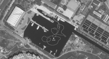
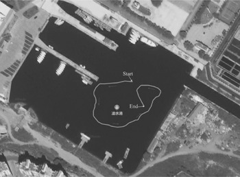
As shown in Figure 13, a large quantity of actual data (2,500 s) was collected during the sea trial process to achieve better training model parameters. Figure 14 shows the experimental trajectory of the USV before explaining the validity of this approach, and Figure 15 illustrates the speed curves of the USV during sailing. The whole time of the USV sailing lasted for about 1,000 s.
Training trajectory of USV in the test

Actual trajectory of USV

Velocity curves of USV during sailing

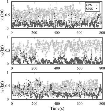
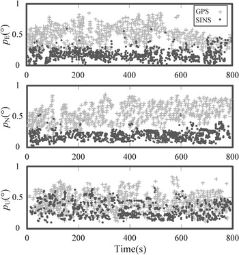
For the first 0–800 s, the GPS was in normal condition, and the GPS signal was then interrupted between 800 and 900 s. Therefore, the integrated system was in training mode between 0 and 800 s. The velocity and position information of GPS and SINS were fused during the training process using the DS approach, and Figures 16 and 17 show their corresponding confidence measure. The velocity and position provided using GPS show better performance than SINS for the confidence measure.
Result of the velocity confidence measure of SINS and GPS during sea trial

Result of the position confidence measure of SINS and GPS during sea trial

The velocity and position outputs derived from GPS were interrupted between 800 and 900 s. Hence, the speed and position data were predicted to replace the GPS-derived speed and position output and thus complete the navigation function. Figures 18 and 19 depict the velocity and position prediction curves of different algorithms in three directions between 800 and 900 s, including the true, GPS measured, DS–ANN predicted, and DS–BL predicted values. From Figures 18 and 19, it can be observed that the velocity and position information predicted by the proposed DS–BL approach are better than the DS–ANN approach in the three directions. The predicted 3D velocity and position values are superior to the measured values on GPS.
Velocity curves of different algorithms during sea trial

Position curves of different algorithms during sea trial

Table 7 shows the mean and STD of the velocity errors in the east, north, and up directions. The mean velocity errors in the three corresponding directions of the proposed DS–BL method were reduced by 15 ⋅ 8%, 92 ⋅ 9%, and 54 ⋅ 9%, respectively, compared with the DS–ANN method. Also, the mean position errors of the proposed DS–BL method were reduced by 18 ⋅ 4%, 23 ⋅ 5%, and 57 ⋅ 1% compared with the DS–ANN method. Additionally, when compared with the DS–ANN approach, the proposed DS–BL method reduced velocity errors by 18 ⋅ 4%, 12 ⋅ 4%, and 49 ⋅ 5%, while the proposed DS–BL method reduced position errors by 29 ⋅ 2%, 31 ⋅ 4%, and 69 ⋅ 2%.
Mean and STD velocity and position errors between two different algorithms during sea trial

Table 8 lists the training and testing time comparison between DS–ANN and DS–BL. It can be observed that the total time of BLS was much quicker than ANN, and the navigation solutions produced using DS–BL were almost close to real-time navigation. The problem of real-time navigation performance can be solved in the future by adopting better hardware devices.
Comparison of training and testing time between DS–ANN and DS–BL

5. Conclusion
This paper proposes a virtual GPS construction method by integrating DS theory and a BL framework. This approach can output the GPS information when GPS signal is interrupted and increase navigation accuracy during GPS unavailability. First, under the condition that a GPS signal is available, the velocity and position information derived from SINS and the corresponding GPS were fused using DS fusion rules. To train the BL network, the fused high-precision speed and position information were used as the inputs of the BL model, while the errors of velocity and position of SINS were selected as the BL output. Second, when the GPS signal was lost, the trained BL framework was used to estimate the velocity and position based on the SINS speed and position information, thereby realising the function of unmanned navigation and enhancing the fault tolerance of the integrated system. To verify the validity and feasibility of the proposed approach, sea trials were performed around Lingshui Port in China. It was established that the proposed approach offers good performance for the USV compared with other methods. In the future, we plan to reduce the navigation error of the USV in cases when the vehicle performs violent manoeuvres that it has never performed before.
Funding statement
This work was supported by the National Nature Science Foundation of China (grant # 51879027), and the 2022 First-Class Discipline Seed Fund of Navigation College, DMU.