

INTRODUCTION
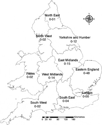
In England and Wales, the potato (Solanum tuberosum L.) industry has changed dramatically in recent decades, from a sector comprised of many small individual farms to one with far fewer but much larger agribusinesses, driven by the need to provide high-quality product to the major processors and supermarkets (Knox et al. Reference Knox, Rodriguez-Diaz, Weatherhead and Kay2010a). In 2009, more than 94 000 ha of potatoes were cropped in England and Wales with an average productivity of 48 t/ha (Potato Council 2010). Over half (0·56) of that area was irrigated, mainly by hose reels fitted with rain guns or booms (Weatherhead Reference Weatherhead2006). The irrigation season typically extends from May to September. Nationally, potatoes are the most important irrigated crop, accounting for 0·43 of the total irrigated area and 0·56 of the total volume of irrigation water abstracted (Knox et al. Reference Knox, Weatherhead, Rodriguez-Diaz and Kay2009). Although the volumes abstracted are relatively small, irrigation is concentrated in the drier eastern regions of England (Fig. 1) and peaks in the summer months, in the driest catchments when water resources are most scarce. This creates conflict with other water demands, most notably those for public water supply and environmental protection.
Proportion of total potato irrigated area in 2009 by region in England and Wales (Source: PC 2010).

The shallow and sparse rooting system of potato plants (Opena & Porter Reference Opena and Porter1999), often resulting from soil compaction (Stalham et al. Reference Stalham, Allen, Rosenfeld and Herry2007), makes it very sensitive to soil moisture stress (Onder et al. Reference Onder, Caliskan, Onder and Caliskan2005). This provides little scope for error in terms of irrigation management, and losses in yield and quality can result even from brief periods of water shortage following tuber set (Shock et al. Reference Shock, Zalewski, Stieber and Burnett1992; Stalham, personal communication). Thus, most rainfed production in England and Wales is concentrated on soils with higher available water capacities (AWC) in regions where summer rainfall is higher, such as Yorkshire, Lancashire and the West Midlands. In contrast, potatoes grown on coarse-textured and well-drained soils are more susceptible to water shortage, and require supplementary irrigation to maintain yield and quality.
The viability of rainfed potato production depends not only on the pedo-climatic conditions but also on the cultivar being grown, its resistance to drought and the tuber quality required by the target market. More than 170 potato cultivars are commercially grown in England and Wales and classified based on their planting and lifting date into ‘earlies’ and ‘maincrop’. Earlies are usually planted in mid-March (southern England) or early April (northern England) and lifted after 10–13 weeks, while maincrop potatoes are usually planted in the first half of April in southern England and in late April further north and lifted normally after 15–20 weeks. These dates vary from year to year depending on the weather conditions. Since they have a shorter growing season, the yield of earlies is normally less than that of maincrop potatoes.
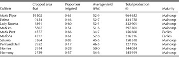
Maris Piper is the most popular cultivar grown in England and Wales; in 2009 it represented 0·19 of the total potato cropped area. The cultivars Estima (0·09), Lady Rosetta (0·06) and Markies (0·06) were also important. The cultivars Estima, Maris Peer, Harmony and Marfona are mainly grown for supermarkets pre-packs, while cultivars Lady Rosetta, Hermes, Saturna and Pentland Dell are favoured for processing (crisping and chipping). A summary of the cropped area, proportion irrigated and average yield of the top 10 cultivars grown in England and Wales is given in Table 1. In the present study, the cropping characteristics used for modelling potato land suitability were based on data for a ‘typical’ Maris Piper crop, the most widespread maincrop cultivar grown by farmers to supply both processing and pre-pack markets; however, the modelling outputs are also relevant to other cultivars with broadly similar responses. Stalham & Allen (Reference Stalham and Allen2001) demonstrated that cultivars differed in their maximum depth of rooting as a consequence of the duration of active root growth rather than in the rate of extension over the first 3–4 weeks after emergence. In a selection of 16 cultivars, Maris Piper rooted to 0·83 m, while the range was 0·67–0·92 m (mean 0·77 m). The other factor that led to the selection of Maris Piper as a test crop was that it is neither particularly drought-sensitive nor resistant and its yield response to irrigation is fairly typical of most cultivars tested. The cultivar is, however, fairly indeterminate, e.g. capable of maintaining full canopy for 50–80 days with moderate fertilizer nitrogen input (typically 150 kg/ha of total nitrogen) (Defra 2010).
A summary on the planted area (ha), proportion irrigated, average yield (t/ha) and total production (t) of the top 10 cultivars grown in England and Wales (derived from PCL data for 2009)

Future changes in climate could affect potato production directly by impacting on plant growth and indirectly by influencing land management practices (e.g. ability of the soil to bear machinery for seed-bed preparation, and the planting and harvesting dates) (Knox et al. Reference Knox, Morris and Hess2010b) and by providing a more favourable environment for new or existing pests and plant diseases (e.g. early blight (Alternaria), soft rot (Pectobacterium) and Colorado potato beetle (Leptinotarsa decemlineata) (Kapsa Reference Kapsa2008)). Warmer temperatures and elevated CO2 levels are expected to result in more favourable growing conditions for most crops grown in northern Europe including potatoes (Olesen & Bindi Reference Olesen and Bindi2002), although of course there will also be some negative consequences, which will vary spatially and temporally (Eitzinger et al. Reference Eitzinger, Orlandini, Stefanski and Naylor2010). The impacts of climate change on the irrigation needs and yield of potatoes grown in England have been assessed by Daccache et al. (Reference Daccache, Weatherhead, Stalham and Knox2011), who combined the downscaled outputs from an ensemble of general circulation models (GCMs) with a potato crop growth model (SUBSTOR-Potato) to simulate future irrigation needs and yield under selected emissions scenario for the 2050s. Assuming crop husbandry factors remained unchanged, farm yields were shown to increase marginally (3–6%), while the average irrigation needs were predicted to increase by 14–30% under the ‘most likely’ low and high emissions scenario, respectively. However, these simulations were for specific locations and ignored future spatial changes in land suitability and the viability of rainfed production.
Internationally, many studies have considered the impacts of climate change on future agricultural land use through scenario modelling and their consequent policy impacts (e.g. Ewert et al. Reference Ewert, Rounsevell, Reginster, Metzger and Leemans2005), but there is remarkably limited literature on the impacts of potential changes in land suitability, a key factor influencing a country or region's ability to adapt agricultural practices to a changing climate. But such analyses can play a critical role in formulating future land policies given the multi-functional role of agriculture and its importance for ecosystem services (Winter Reference Winter2009). For example, Hood et al. (Reference Hood, Cechet, Hossain and Sheffield2006) determined the future potential for growing cool season grapes, high-yield pasture and blue gum in Victoria, Australia by combining land suitability analysis with climate change scenarios within a geographical information system (GIS) framework. In Scotland, Brown et al. (Reference Brown, Towers, Rivington and Black2009) demonstrated the importance of soil moisture on land-use options, and how shifts in land-use potential have implications for both strategic resource planning and for adaptation actions. Their assessment highlighted not only potential changes in agriculture and other productive land uses but also repercussions for biodiversity and terrestrial carbon stocks.
As part of a broader study investigating the impacts of climate change on the UK potato industry, the objective of the present paper was thus to develop a methodology using pedo-climate functions and a GIS to model and map the current and future land suitability for potato production in England and Wales. The outputs would help the agrifood industry and its 3000 potato growers to identify regions where future rainfed potato production might become limiting, and where future irrigated production might be constrained due to water resource limitations.
MATERIALS AND METHODS
In summary, a three-stage methodology was developed. Firstly, the current land suitability for maincrop potato production was modelled and mapped using a GIS. This provided a reference or ‘baseline’ from which the derived land suitability classes could be validated against observed data on the spatial distribution of potato cropping (for rainfed and irrigated production). Secondly, future potato land suitability was modelled using the latest projections of climate change (UKCP09) produced by the UK Climate Impacts Programme (UKCIP) (Jenkins et al. Reference Jenkins, Murphy, Sexton, Lowe, Jones and Kilsby2009). A comparison with the baseline suggests how land suitability classes at each point might alter due to changes in rainfall, temperature and other agroclimatic variables, and thus potential impacts on current centres of production. Finally, the relationships between land suitability and water resource availability were assessed, to identify catchments where future irrigated production might be most at risk of water constraints and whether it could relocate to catchments with less stressed resources. From this, the implications of climate change can be assessed, including where rainfed production might cease to be viable, which cultivars are likely to be most or least suited to changes in land suitability and the range of adaptation options (e.g. shifting production, new soil management techniques, drainage and new irrigation infrastructure) that should be considered. A brief description of each stage is given below.
Assessing current potato land suitability
Characterizing the edaphic (soil related) and climatic regions suitable for the production of a specific crop type generally requires a long time frame, coupled with extensive experimentation and experience, and significant resources (Siddons et al. Reference Siddons, Jones, Hollis, Hallett, Huyghe, Day, Scott. and Milford1994). However, provided that land types and local climates can be adequately specified and sufficient knowledge is available regarding crop responses to soil and weather factors, then land suitability models offer an alternative and rapid means of producing maps and data sets showing suitable areas for a particular crop. The Soil Survey of England and Wales (now incorporated in the National Soil Resources Institute) previously developed a suite of land suitability models for a range of arable crops (Jones & Thomasson Reference Jones, Thomasson, Beek, Burrough and McCormack1987; Hallett et al. Reference Hallett, Jones and Keay1996). The present study used the land suitability model for potatoes (Jones & Thomasson Reference Jones, Thomasson, Beek, Burrough and McCormack1987), which defines a number of parameters of which most are climatic or soil related, but some are site-specific. A brief summary of the land suitability modelling framework used is given below.
Definitions of land suitability
The four land suitability classes used by the National Soil Resources Institute, termed well suited, moderately suited, marginally suited and unsuited (Thomasson & Jones Reference Thomasson and Jones1991) follow the approach pioneered by the FAO (1976). Well suited land has a high and sustainable production potential. There is adequate opportunity to establish the crop in average years at or near the optimum sowing time and harvesting is rarely restricted by poor ground conditions. Even in wet years, working conditions are acceptable and do not prevent crop establishment. There are sufficient soil water reserves to meet the crop water demand even in a dry year (typically defined as when reference evapotranspiration (ET) exceeds rainfall every month during the summer growing season). Moderately suited land has moderate or high potential production, but yield is variable from year to year due to either shortage of soil water to sustain full growth or to poor conditions at crop establishment, affecting either sowing time or soil structure. Marginally suited land has a potential production that is variable from year to year with considerable risks, high costs or difficulties in maintaining continuity of output. The variability is due to climate interacting with soil properties. The criteria for unsuited land vary from crop to crop but are mainly related to climate, gradient and stoniness, although the latter can be largely overcome with de-stoning machinery. Clearly, near the climatic limits there will be favourable years which allow efficient production but other years could be too wet or too cool for the development of potato plants (Jones & Thomasson Reference Jones, Thomasson, Beek, Burrough and McCormack1987).
Criteria for identifying unsuited land
Given these land suitability definitions, four variables are used to distinguish between unsuited and suited (well, moderate, marginal) land; namely, potential soil moisture deficit (PSMD), accumulated temperature (AT), level of stoniness and slope. In the model, these identify areas where either climatic conditions (extreme cold and/or wet areas) and/or soil characteristics (high levels of stoniness and sloping relief) would limit potato production.
The variable, maximum potential soil moisture deficit (PSMDmax) has been used in various studies internationally (De Silva et al. Reference De Silva, Weatherhead, Knox and Rodriguez Diaz2007; Rodríguez Díaz et al. Reference Rodríguez Díaz, Weatherhead, Knox and Camacho2007; Knox et al. Reference Knox, Rodríguez Díaz, Nixon and Mkhwanazi2010c) as an agroclimatic indicator to assess the level of drought and to quantify the spatial and temporal changes in crop water requirements. It represents the monthly maximum accumulated excess of reference ET over rainfall (P) during the summer months, and is calculated using a monthly water balance model:

where PSMDi is the PSMD in month i (mm), Pi is rainfall in month i (mm) and ETi is the reference ET of short grass in month i (mm), calculated using the Penman–Monteith method (Allen et al. Reference Allen, Smith, Perrier and Pereira1994). Under the humid UK climate, the PSMD calculation starts in January (i=1) where a zero soil deficit is assumed. In the majority of years, this is a valid assumption, given that winter rainfall replaces any soil water deficit that has accrued over the preceding summer months. The moisture deficit starts to build up in early spring as ET>P, peaks in mid-summer (July–August) and then declines in autumn and winter as P>ET. The maximum PSMD of the 12 months is the PSMDmax value at that given site. In the present study, a 5×5 km resolution dataset of the long-term average PSMDmax (1961–90) was used to identify areas of excess wetness or aridity. Average values of PSMDmax less than 75 mm were considered too wet for a successful potato crop owing to limited working days for machinery (trafficability), particularly during harvest (Thomasson & Jones Reference Thomasson and Jones1991).
AT is defined as the integrated excess of temperature above a fixed base value or threshold over a defined period (month or year). It is a reasonable guide to the energy input since it correlates with crop potential and vegetation growth. It is thus a measure of the degree of the warmth available for plant growth. In the present study, the AT value from January to June above 0°C was generated using a methodology developed by Hallett & Jones (Reference Hallett and Jones1993) where an AT<1125 day-degrees above 0°C is considered too cold for potato production (Jones & Thomasson Reference Jones and Thomasson1985).
Fields with steep slopes can limit the use of the heavy planting and harvesting machines involved in potato production. Therefore, fields with a slope greater than 8·5° were classified as unsuitable for potato production regardless of their pedo-climatic characteristics. Damage caused by soil clods and stones during harvesting can reduce tuber quality, and hence crop value. Even though stoniness problems can be alleviated to a certain extent by modern harvesting and de-stoning machinery, soils with stone proportions higher than 0·15>0·06 m diameter in the top 0·25 m soil are not desirable and were assumed to be unsuited for potato cultivation.
Classification of suited land
The two main criteria used for differentiating between the suited land classes are trafficability and droughtiness (defined below), as these can have a considerable impact on tuber quality as well as yield. The former is measured as machinery work days (MWD), as described by Thomasson & Jones (Reference Thomasson, Jones, Jones and Biagi1989), and the latter from available water (AW) and soil moisture deficit (SMD) data (Jones & Thomasson Reference Jones, Thomasson, Beek, Burrough and McCormack1987). A summary of each criterion is given below.
Trafficability
A number of thresholds for workability are definable in soil terms by moisture state (matric potential), bulk density, penetration resistance, or shear strength. The most obvious threshold defines the boundary between ‘go’ and ‘no-go’ for vehicle movement on the land. Another threshold, perceived as less limiting, occurs when work on the land is not precluded but cannot be performed efficiently without damage to the soil. The need is to identify for the farmer ‘no-go’, ‘acceptable’ and ‘optimum’ conditions for tillage or other operations at any moment in time. Initially, Thomasson (Reference Thomasson1982) proposed assessing opportunities for cultivations in terms of ‘good’ machinery workdays using soil characteristics together with the rainfall pattern to predict the number of days when heavy machines have reasonable access to fields for crop husbandry practices (Rounsevell & Jones Reference Rounsevell and Jones1993). Insufficient MWD can affect crop development indirectly. For example, a delayed planting date caused by heavy spring rains would shift the growing season and increase the cold damage risk in late development stages. The harvesting date may coincide with heavy rainfall with consequences for market price, yield and tuber quality. In 2000, c. 0·20 of the potatoes grown in England were harvested late due to excessive autumn rain limiting machinery access onto land (Collier et al. Reference Collier, Fellows, Adams, Semenov and Thomas2008). Under the same climatic conditions, water logging and saturation are more likely to occur in fine-textured and slowly permeable soils than in well-drained, coarse-textured soils. The aim of the workability system adopted in the present paper is to estimate the average number of days acceptable for non-damaging traffic and tillage within the autumn period (1 September–31 December) and in the spring period (1 March–30 April), using empirical relationships between soil and weather conditions.
Threshold criteria for MWD can be generalized such that for autumn-sown crops an average value of more than 50 days is desirable to ensure that, even in a 1 in 4 wet year, there are at least 30 days to allow cultivation and drilling on major areas of land before conditions become unacceptable. For spring-sown crops, similar criteria would suggest a minimum of 20 days in average years to ensure that in the 1 in 4 worst (wet) year there is some opportunity to establish the crop (Jones & Thomasson Reference Jones, Thomasson and Kimble1993).
Droughtiness
The term drought is essentially climatic, implying a lack of an expected amount of rain; assessment of soil droughtiness widens the term considerably to include three aspects – climate or weather, soil water relations and plant requirements. To achieve potential yields, appropriate soil moisture conditions need to be maintained during the growing season. Under rainfed practices, yield is highly dependent on the droughtiness of that area. This depends on the pattern of rainfall, rates of ET and on local soil characteristics. Hall et al. (Reference Hall, Reeve, Thomasson and Wright1977) introduced a more objective method of assessing soil droughtiness by calculating the excess of average potential ET over average rainfall (moisture deficit) during the growing season of the crop and comparing this with the available soil water reserves within the depth likely to be exploited by each crop. This method is described in detail by Thomasson (Reference Thomasson, Jarvis and Mackney1979) and has been applied in the present paper taking into account an average rooting depth of potatoes of 0·7 m (Durrant et al. Reference Durrant, Love, Messem and Draycott1973) and foliar characteristics to estimate the average soil–moisture balance (SMB) at a given location:

where AWCpot is the available soil water holding capacity adjusted to the potato crop (mm), and SMDpot is the SMD adjusted to potato crop (mm). AWCpot is a measure of the quantity of water held in the soil profile that can be taken up by the potato crop (mm/m). It is highly dependent on soil characteristics (i.e. texture, structure, organic matter and stoniness) and potato rooting depth. A detailed description of the method used to calculate AWCpot is given in MAFF (1988). Hall et al. (Reference Hall, Reeve, Thomasson and Wright1977) define classes of droughtiness as follows: non-droughty >50 mm, slightly droughty 0–50 mm, moderately droughty −50 to 0 mm and very droughty >−50.
The PSMD calculation described earlier is normally calculated for a grass crop, but for potatoes the calculation needs to account for the limited ground cover during the early growth stages. Under UK conditions, maincrop potato has an almost negligible leaf cover until mid-May, while the full leaf cover is achieved only after the end of June (Allen & Scott Reference Allen and Scott2001). Therefore, Jones & Thomasson (Reference Jones, Thomasson, Beek, Burrough and McCormack1987) described the following equation for deriving SMDpot from the monthly accumulated values of PSMD grass:

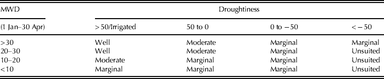
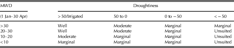
PSMDAug is therefore reduced significantly but in a manner similar to the approach used in irrigation experiments to estimate the actual SMD. The adjustment terms in Eqn (3) are based on the reasonable assumption that main-crop potatoes can be considered to be in bare ground conditions until mid-May, with full ground cover only achieved by about the end of June. Growth then continues through the period to the end of August when crop water requirements diminish with the onset of senescence (Thomasson Reference Thomasson, Jarvis and Mackney1979). The land suitability for potato cultivation was classified by combining the data on MWD with droughtiness (Table 2), after the climatic thresholds for AT and PSMD have been applied. Irrigation can address the droughtiness problem assuming no physical, technical or economical limitations exist. Therefore, the land suitability classification for irrigated potato production ignores the droughtiness effect.
Land suitability classes based on MWD and droughtiness, for rainfed and irrigated potatoes
Mapping current potato land suitability
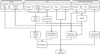
The individual components in the potato land suitability model are summarized in Fig. 2. The model relies on two national data sets. The soil data set includes detailed spatial soil properties relating to texture, structure, permeability, drainage status, accessibility and workability, with data aggregated to a 5×5 km resolution grid pixel map within a database known as the Land Information System (LandIS) (Keay et al. Reference Keay, Hallett, Farewell, Rayner and Jones2009), in which the properties of the dominant soil types from the National Soil Map of England and Wales (Soil Survey 1983) have been averaged. The climate data set uses the UK Meteorological Office (UKMO) database, containing long-term mean-monthly climate data for 1961–90 for a wide range of variables, also resolved to a 5×5 km resolution.
Schematic framework for assessing potato land suitability.

Using a GIS, the spatial data sets relating to soils and agroclimate, the variables described in Fig. 2 and the criteria for land suitability assessment (PSMD, stoniness, slope, AT, MWD, droughtiness) were integrated to model and map potato land suitability in England and Wales. However, these first outputs include all non-arable areas, for example, urban areas, water bodies and forests. An arable land use mask was therefore required to exclude all ‘non-arable’ land. For this, the CORINE land-cover data set (CLC2000) was used, which is based on IMAGE2000, a satellite imaging programme undertaken jointly by the Joint Research Centre of the European Commission and European Environment Agency (EEA) (Bossard et al. Reference Bossard, Feranec and Otahel2000). CORINE provides data for five different land-use categories (artificial surfaces, agricultural areas, forest and semi natural areas, wetlands and water bodies), which are further disaggregated into 44 land cover classes. Some 6·2 million ha or 0·42 of the total area of England and Wales are classified as ‘arable’ land, defined as being suitable for either rainfed or irrigated crop production (excluding permanent grassland). Using the GIS, the potato land suitability data set was overlaid onto this arable land mask to map the suitability of current arable land for potato production in England and Wales.
Mapping future potato land suitability
Uncertainties in the outputs from GCMs are divided between emission uncertainty and modelling uncertainty (Cox & Stephenson Reference Cox and Stephenson2007). As greenhouse gas emissions are determined by different driving forces such as demographic development, socio-economic development and technological changes, the Intergovernmental Panel on Climate Change (IPCC) has produced four different socio-economic storylines (termed A1, A2, B1 and B2) to describe the relationships between the driving forces and their evolution (Meehl et al. Reference Meehl, Stocker, Collins, Friedlingstein, Gaye, Gregory, Kitoh, Knutti, Murphy, Noda, Raper, Watterson, Weaver, Zhao, Solomon, Qin, Manning, Chen, Marquis, Averyt, Tignor and Miller2007). Each leads to a different emission scenario, with c. 40 emissions scenarios and six marker scenarios being defined. The latest projections from the UKCIP, known as UKCP09, uses IPCC defined scenarios A1FI, A1B and B1 (Nakicenovic et al. Reference Nakicenovic, Alcamo, Davis, De Vries, Fenhann, Gaffin, Gregory, Grübler, Jung, Kram, La Rovere, Michaelis, Mori, Morita, Pepper, Pitcher, Price, Riahi, Roehrl, Rogner, Sankovski, Schlesinger, Shukla, Smith, Swart, Van Rooijen, Victor and Dadi2000), renamed for simplicity as high, medium and low, respectively.
Modelling uncertainty results from incomplete understanding of the climate system or an inappropriate representation of the complex climate system within a single model. For this reason, many studies use the outputs of multiple future climate projections to increase the confidence in the climate projections (Fisher et al. Reference Fischer, Shah, Tubiello and Van Velhuizen2005; Lobell et al. Reference Lobell, Burke, Tebaldi, Mastrandrea, Falcon and Naylor2008). UKCP09 has dealt with the major source of modelling uncertainty by using the outputs of a large ensemble of variants from the HadCM3 GCM and from 12 other international GCMs as well as dynamically downscaling the GCM results using the regional climate model HadRM3 (Jenkins et al. Reference Jenkins, Murphy, Sexton, Lowe, Jones and Kilsby2009). As a consequence, 10 000 samples of possible and plausible changes for each climatic variable are available, and the results are presented in terms of likelihood probability. In the present study, the central estimate (0·50) for each climate variable for each pixel was extracted for each emission scenario as a monthly gridded data set at 25×25 km resolution, expressed as a percentage change relative to the baseline (1961–90), and used to perturb the UK Meteorological Office 5×5 km resolution baseline climate data set. Consequently, the future climatic parameters such as rainfall, temperature and ET were obtained for England and Wales at a grid resolution of 5×5 km. Using the UKCP09 climatology, the individual criteria for land suitability (Fig. 2) were again integrated in the GIS and used to produce a series of maps showing the most likely future land suitability for each pixel, for rainfed and irrigated potato production, for the 2050s and 2080s, for the low- and high-emissions scenario, respectively. As before, the CORINE data set was used to constrain the spatial analysis to arable land only.
Land suitability and water resources
The reliance on supplemental irrigation is increasing in order to reduce the effects of climate variability on crop yield and quality. But water resources are under intense pressure due to rising demand, competition between sectors and the longer term threat of climate change. Concerns have also been raised over the potential impacts of irrigation on the environment (Hess et al. Reference Hess, Knox, Kay, Weatherhead, Hester and Harrison2010). Indeed, in many catchments, summer water resources are already over-committed and additional summer licenses for surface and groundwater irrigation abstraction are unobtainable.
Information on the distribution of potato holdings across England and Wales are collected annually by the Agriculture and Horticulture Development Board (AHDB) as part of its statutory duty. The level of detail in the public domain depends on its commercial sensitivity, but the data can be used to map the spatial distribution of potato growers. In England and Wales, the water regulatory authority, the Environment Agency (EA), has assessed the availability of water resources for abstraction at a catchment level (EA 2010). Each catchment has been defined according to its resource status and allocated to one of four categories in order of increasing stress: (i) ‘water available’, where additional water is likely to be available at all flows including summer low flows, (ii) ‘no water available’, where no water is available for further licensing at low flows, although water may be available at higher flows with restrictions, (iii) ‘over-licensed’, where current actual abstraction is such that no water is available at low flows and if all existing licenses were used to their full allocation they could cause unacceptable environmental damage at low flows and (iv) ‘over-abstracted’, where existing abstraction is causing unacceptable damage to the environment at low flows, although water may still be available at high flows. Using the GIS, these two data sets were combined to correlate the distribution of potato growers relative to water resources availability.
RESULTS
Current potato land suitability
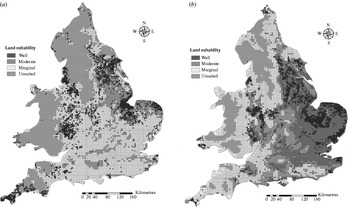
Figure 3 shows the spatial distribution of current land suitability for rainfed and irrigated potato production across England and Wales. Land classified as being well suited for rainfed production (Fig. 3a) is restricted to small pockets located in Cambridgeshire (notably along the Washland Fens), in parts of north Lincolnshire and south Yorkshire. This land occupies <0·04 of the total arable land in England and Wales. In a typical wet year, the land would be dry enough to support appropriate working machinery and in a dry year, the available soil moisture levels would be sufficient to meet crop water needs. Moderately suited land for rainfed production extends across c. one-third (0·35) of arable land in England and Wales, covering north Norfolk, south Yorkshire, Lincolnshire and parts of the East Midlands. There are also small areas located in Kent, Shropshire and Hampshire. The production potential of this land ranges from high to moderate and depends on the annual variation in agroclimatic conditions. Nearly two-thirds (0·59) of arable land in England and Wales is considered to be marginally suited for rainfed potato production under current climate conditions, with production unreliable and highly dependent on weather conditions. These areas extend across much of eastern, central and southern England. In dry years, potato establishment on this land might fail due to excessive drought conditions and low soil moisture levels; conversely, in wet years production would fail due to poor trafficability and saturated soils. The areas of unsuited land are, not surprisingly, across large tracts of Wales, South West and North West England, where lower temperatures combined with high rainfall and steep slopes limit successful potato cultivation.
Land suitability for (a) rainfed and (b) irrigated maincrop potato production under reference baseline climate conditions (1961–90). The dots correspond to the location of (a) rainfed and (b) irrigated potato fields for the 2009 cropping season.

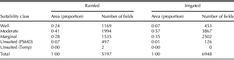
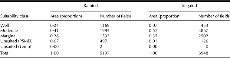
In contrast, land well suited and moderately suited for irrigated potato production (Fig. 3b) represents 0·60 and 0·26 of the total arable land in England and Wales, respectively. This extends across much of eastern and south east England. Only a small fraction (0·10) is considered marginally suited for production due to restricted MWD and <0·04 due to temperature restrictions. The areas of land unsuited for irrigated production correspond closely with those unsuited for rainfed production. The spatial accuracy of this classification can be validated against data on the distribution of rainfed and irrigated growers in 2009 (Fig. 3). The proportion of rainfed and irrigated cropping located within each land suitability class was derived (Table 3) and the findings are consistent with the land suitability classification. The majority of rainfed potatoes are located on well suited (0·24) and moderately suited (0·41) land, as these conditions can guarantee commercial levels of production. Irrigated fields are mainly concentrated on land which is only moderately (0·57) or marginally (0·35) suited for rainfed production as supplementary irrigation helps overcome the risks associated with droughtiness. Potato production is absent in areas where temperatures are too cold (AT<1125°C) for potato plant establishment, while only a small proportion of rainfed (0·07) and irrigated (0·01) fields were on land with PSMDmax<75 mm. Of course, in these areas other crops may also be more economically viable, rather than potato production being limited solely by biophysical conditions.
Total area (proportion) and number of fields used for rainfed and irrigated potato production in 2009, by land suitability class
Future potato land suitability
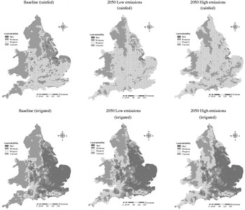
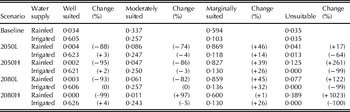
Figure 4 shows the modelled land suitability for each pixel for rainfed and irrigated potato production for the 2050s for the low- and high-emissions scenario, and a summary of the projected impacts is given in Table 4. Compared with the baseline, increases in the magnitude and extent of droughtiness significantly reduce the area of land likely to be well suited and moderately suited for rainfed potato production, particularly around north Norfolk, the Fens and Lincolnshire. Most of the moderately suited land here is likely to become marginally suited due to the warmer, drier summers. However, some areas in south western England that were previously classified as unsuitable are likely to become marginally suited due to warmer (summer and winter) temperatures and an increase in the number of MWD. By the 2050s, land currently classified as well or moderately suited for rainfed production is likely to decline, by 74 and 95% under the low- and high-emissions scenarios, respectively. Conversely, the land that is currently marginally suited for rainfed production is expected to decline in the 2050s by 46 and 39% under these emissions scenarios.
Future land suitability for rainfed and irrigated maincrop potatoes for the UKCP09 2050s low and high emissions scenarios. Maps are based on the ‘most likely’ (0·50) probability (central estimate) UKCP09 data.

Classification (proportion of total arable land) of arable land suitability for rainfed and irrigated potato production in England and Wales for the baseline, and projections for the 2050s and 2080s using low and high emissions scenarios. Values in parenthesis are % future changes relative to the baseline

For irrigated potato production, the projected changes in climate are expected to cause only minor increases in the area of well and moderately suited land. This positive impact is mainly observed in areas previously considered under the baseline (1961–90) to be too wet or too cold for production. However, the small area of land unsuitable for irrigated production is projected to shrink further (Table 4). The areas affected are in Wales and northwest England, where unsuited land might become marginally or moderately suited for irrigated potatoes. These changes could offset some of the negative impacts of climate change in drier parts of England.
Potato production and water resources
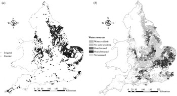
Figure 5 shows the distribution of potato growers relative to water resource availability. The major regional areas of production are concentrated in eastern England (Norfolk, Cambridgeshire and Suffolk), the west midlands (Hereford, Shropshire and Staffordshire) and north east (South Yorkshire). There are also pockets in Kent and the south west (Fig. 5a). In comparison, the areas of severe water resource stress are predominantly located in catchments in eastern and south east England, where over-abstraction is thought to be causing unacceptable damage to the environment (EA 2010). There are also large areas of central and north eastern England defined as either ‘over-licensed’ or having ‘no water available’. Only a small proportion of potato growers are located in catchments with ‘water available’ (Fig. 5b).
Distribution of PCL reported rainfed and irrigated potato fields in 2009 in England and Wales (a), and arable land classified according to water resources availability (b).

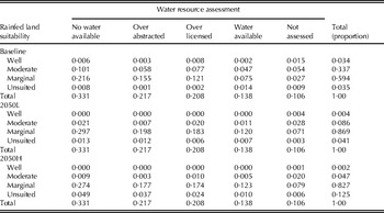
The impacts of climate change on rainfed land suitability relative to water resource availability are summarized in Table 5. For the baseline, the analysis shows that a third (0·34) of all arable land is moderately suited and two-thirds (0·59) marginally suited for rainfed production, with the majority located in catchments where ‘no (additional) water’ is available. Nearly half (0·43) of all arable land is within catchments defined as having severe water stress (over abstracted and over-licensed). By the 2050s, the majority of arable land for rainfed production (0·87) would be classified as being marginal, with 0·43 located in over-licensed and/or over-abstracted catchments. Clearly, for growers switching from rainfed to irrigated production to maintain potato yields in the future, the availability of water resources could be a major constraint. The present analysis also assumes no change in future resource availability, which itself is projected to worsen significantly (Charlton & Arnell Reference Charlton and Arnell2011). The potential implications on the potato industry, the adaptation options and the uncertainties associated with the analyses are summarized below.
Classification of arable land suitability (proportion of total arable land suited for rainfed production) for rainfed potato production in England and Wales against water resources availability for the baseline and the 2050s high and low emissions scenarios

DISCUSSION
Implications for potato production
The full impacts of climate change on potato production are clearly more complex than the basic criteria used in the present analysis, but the results agree well with qualitative judgment. For example, drawing on industry data comparing potato production costs and benefits in 2009, the cost of production would not be covered by the crop value when maincrop yields fall below 30 t/ha. This would set a limit for rainfed production in the dry regions and those having coarse and easily drained soils. A restricted water supply during crucial times during the growth cycle can also cause damage to the tuber quality (e.g. common scab) to the extent that certain cultivars would be rejected by the market. This would force growers to change to cultivars less susceptible to this disfiguring disease or focus more towards the processing market. Any reduction in irrigation availability or reduction in rainfall would severely affect the profitability of cultivars such as Maris Piper and Maris Peer, where skin finish is crucial for the saleability of pre-packs. Determinate cultivars, i.e. those that only produce a limited leaf area and have short periods of active root growth, and some less-determinate cultivars are very sensitive to water restriction during the mid-late canopy expansion phase. Current widely grown examples include Estima, Lady Rosetta and Saturna. Absence of rain or irrigation during the mid-late canopy expansion periods can cause premature senescence with a large yield loss. For this reason, rainfed or limited irrigation production with these cultivars under these climate change projections are likely to be reduced for risk of crop failure. However, the yield response to irrigation of many of these cultivars is large so they will continue to be grown where irrigation is less limited. Production in rainfed areas is likely to change in the future to cultivars that are able to either (i) survive early drought periods, so that they can use rainfall later in the season (e.g. cvars Cara, King Edward, Markies, Russet Burbank or Rooster) or (ii) partition dry matter towards tuber production during periods of drought rather than canopy production that makes them more efficient in producing yield per unit of water use (e.g. cvars Hermes or Desiree).
Climate change is likely to lead to the dates of the last spring frosts becoming earlier and autumn frosts becoming rarer and/or later, thereby extending the growing season. Planting could therefore take place earlier as the thermal environment experienced by crop canopies would be more favourable. However, soils could still be at field capacity at this time, leading to the same problems in workability that growers currently experience during March and April in many regions of the country. Reduced rainfall and higher temperatures could result in a depletion of organic matter, thus increasing the risk of structural damage to sensitive soils (Jones et al. Reference Jones, Hiederer, Rusco and Montanarella2005; Verheijen et al. Reference Verheijen, Bellamy, Kibblewhite and Gaunt2005). As a consequence of later autumn frosts, the harvesting period (window) would become longer, thereby reducing the risk of adverse soil conditions causing harvesting problems or crop damage.
Adaptation options related to water resources
The present results show clearly that growing rainfed potatoes in England and Wales will become increasingly risky as a result of climate change, and limited to a few favourable areas. This is consistent with studies elsewhere in Europe that highlighted the risks to rainfed production (Trnka et al. Reference Trnka, Eitzinger, Dubrovský, Semerádová, Štěpánek, Hlavinka, Balek, Skalák, Farda, Formayer and Žalud2010). In contrast, with irrigation the land suitability hardly changes and most of the current rainfed potato production could remain in its present location if it could be irrigated. Although only c. 0·01 of water abstraction in England and Wales is used for irrigated agriculture, there is limited prospect of the industry obtaining significant additional licensed quantities for the summer months in the face of competing demands (Weatherhead & Howden Reference Weatherhead and Howden2009). However, many existing licences are unused or underused, so water transfers or abstraction licence trading between farms may be an option, though there are environmental concerns regarding re-activating ‘sleeper’ licences in stressed catchments, as this would lead to an increase in water abstraction and exacerbate the existing resource-stressed situation.
Licences are still available for high flow (off-season) abstraction in most catchments, and recent years have seen a significant increase in winter-filled on-farm reservoirs for irrigation use in the summer. Although expensive, these provide growers with a greater security of supply, and it seems likely that these will become the preferred irrigation water source for potatoes and other high value vegetables in the south and east of England. Tompkins et al. (Reference Tompkins, Adger, Boyd, Nicholson-Cole, Weatherhead and Arnell2010) noted that there are still relatively few examples of adaptation to climate change in the UK agricultural sector, and that many apparently adaptive actions have actually been in response to legislative or other pressures, rather than purposeful (deliberate) planned adaptations to perceived climate change per se. Nevertheless, they may still be useful climate change adaptations, and the current growth in on-farm reservoirs would appear to fall into this category.
Once irrigation water is assured, albeit expensive and/or valuable, it will become sensible to invest more heavily in water efficiency measures; better application methods, including drip and precision irrigation, and scientific scheduling methods will become standard. Earlier planting and harvesting would reduce water use per unit area, but with some cultivars, growers might prefer to use the longer growing season to increase yield. There has been a steady increase in average potato yields over the last 40 years (Potato Council 2010); with the consumption roughly constant this has led to a gradual reduction in total area planted throughout the UK as a whole. Whether this trend can be intensified and how far it could counteract the increasing water demand is not yet clear. Previous authors (Downing et al. Reference Downing, Butterfield, Edmunds, Knox, Moss, Piper and Weathehread2003) have suggested that irrigated production might move north and west as an adaptation to climate change. Given that most of the current locations remain suited to irrigated production, this may be a slow process. Many growers have sizeable investment in fixed assets, and may therefore prefer to remain at their present locations renting land from neighbours with unused or partially used licences as a preferred adaptation.
Methodological limitations
The concept of land suitability for a particular crop is complex. The scheme adopted in the present paper assumes good management using appropriate cultivars, fertilizer applications, rotations, crop protection, irrigation if needed and drainage measures. Suitability is assessed for sustained production in a rational cropping system. From the land manager's perspective, there can be movement between suitability classes if some of these aspects are absent, or applied in either a particularly beneficial or detrimental way, but the current land classification system has no capacity to take this into account. Other social and economic factors have been excluded, as have differences in farm size and layout that can also affect cropping preferences and override intrinsic land suitability. Furthermore, competition between competing land uses has not been taken into account, though this is not unreasonable given the high value of potato production. Land suitability was based on the average climate for the period 1961–90 and average soil property data, and checked against the location of potato fields in 2009, which was a relatively dry year. The results must be interpreted with these limitations in mind, but quartiles and standard deviations for climatic data would allow examination of the effects of extreme conditions on land suitability class.
A major problem for all projections of land productivity, including the land suitability assessments reported in the present paper, is spatial resolution. Crop cover and topography can usually be spatially resolved to 10 m; but soil data are rarely resolved to closer than 100 m and, for most parts of the UK, data at 1000 m resolution are the norm. Similarly, for climate data, due to the relatively few fully instrumented recording stations, the best obtainable resolution is generally 5–10 km. Finally, the land suitability assessment system was designed for application across wide areas and over long periods (seasons) and is not valid for assessment in the short-term (Rounsevell & Jones Reference Rounsevell and Jones1993). However, as currently configured, the system provides objective assessments of land suitability based on standard data sets, thus facilitating regional comparisons, and the opportunity for forward strategic planning.
The climate-change impacts were based on probabilistic projections developed by UKCP09, although other projections using different GCMs are also available. However, the UKCP09 climatology is not spatially coherent across pixels. In interpreting the maps in the present paper, it is therefore important that the projected changes in land suitability are considered at the individual grid pixel level, rather than considering them as a continuum. Thus, the assessment of future land suitability undertaken is valid for each individual site (or grid pixel) but the changes or impacts implied at each point need to be considered separately and not treated as spatially coherent, i.e. they should not be regarded as outcomes that would necessarily all happen together (Sexton et al. Reference Sexton, Harris and Murphy2010). Where impact assessments need to consider multiple locations that cannot be treated as separate entities (e.g. estimating future irrigation water demand for a catchment), Sexton et al. (Reference Sexton, Harris and Murphy2010) recommend using an ensemble of spatially coherent projections (SCPs) based on the Met Office regional climate model (HadRM3), although these themselves are limited to only a single-emission scenario, under-sample the uncertainties in the UKCP09 and do not give the UKCP09 ‘most likely’ impact for each given point.
The future climate data sets and modelling approaches contain a high degree of uncertainty (particularly by the 2050s), as discussed earlier. The high- and low-emissions scenarios were used, though it is not necessarily true that the outcome will lie between these. The analysis of each was then based on the central estimate values (0·50 probability), but there is significant variability for each climate parameter. The complexity of the modelling would make it difficult to run the large number of 10 000 climate data sets available in UKCP09 in order to estimate the standard deviations around the results; future research could investigate ways to approximate this. Finally, the water resource availability data set used was for current conditions. Clearly, these will also alter by the 2050s, but equivalent future data based on UKCP09 is not yet available. Modelling from earlier projections has indicated that availability of summer water will decline significantly in most of the potato producing areas. Similarly, the arable land is based on current data. Climate change could encourage some conversion from arable to non-arable use, and vice versa, and some land is likely to be lost to urbanization and other uses.
The main conclusion from the present study is that the land suited for rainfed potato production in England and Wales is projected to decline markedly under the climate change scenarios used. In contrast, most of the current arable land will still be suited to irrigate potato production. Cultivation is likely to shift substantially towards irrigated production where water is available. The resulting increase in water demand is potentially very much larger than the increase in the irrigation need of the presently irrigated crops. Irrigation is likely to be supported by practices including water licence trading, greater use of on-farm reservoirs and more efficient irrigation, but will inevitably raise further questions about the level of water allocation to food production. These outputs are a very valuable starting point for opening a dialogue between the UK agricultural levy boards, water and environmental stakeholders, the agri-industry and government policy makers regarding the adaptation options for crop production. Shifts in land-use potential have serious implications for both strategic water and land resource planning and food security.
This research forms part of a contract (R404) funded by the UK Potato Council (PCL). The authors acknowledge the PCL for their financial support and provision of industry statistics, the UKCIP for the UKCP09 climatology, the National Soil Resources Institute for provision of soil and agroclimate data sets, and the anonymous reviews for their insightful comments which helped to improve the paper.