


Introduction
Hagbard’s Gallows (Hagbards galge in Swedish) is a prominent Bronze Age (1700–500 BC) monument located in Asige parish, Halland, south-western Sweden (Figure 1). It consists of two pairs of monumental standing stones positioned on two mounds 40m apart. The standing stones are 3.5–4.0m high and three are decorated with motifs that include concentric circles, human figures, circle images and a ship (Figures 2 & 3) (Broström & Ihrestam Reference Broström and Ihrestam2015; Skoglund et al. Reference Skoglund2025). While monumental standing stones, rock art and burial mounds are found across Scandinavia, this combination of all three is otherwise unknown in northern Europe. The monument also has great regional significance due to its association with the medieval legend of Hagbard and Signy, which is regularly enacted as a local theatre play.
Map of Scandinavia with the location of the site indicated (figure by Anders Andersson & Stina Tegnhed, Kulturmiljö Halland).

Hagbard’s Gallows. View from the south (photograph by Tony Axelsson).

Laser-scan documentation and visualisation of the rock art at Hagbard’s Gallows using the topography visualisation toolbox (https://tvt.dh.gu.se/): a) stone 17:3; b) stone 17:6 (laser scan: Rich Potter; visualisation: Christian Horn; after Skoglund et al. Reference Skoglund2025: fig. 5).

Despite its unique character, no archaeological excavations have been carried out at the site to date. Instead, its chronology is inferred through comparative approaches, including rock art typology, which date the monument to c. 1100–900 BC (Skoglund et al. Reference Skoglund2025). The project ‘Hagbard’s Gallows and the Bronze Age cultural landscape’ was initiated in 2023 (Tegnhed & Skoglund Reference Tegnhed and Skoglund2025), with the aim of addressing questions concerning the monument’s dating, its relationship to the surrounding cultural landscape and the significance of the site within Bronze Age society.
Fieldwork and analysis
The project was designed to work in close partnership with the local community through the Asige Historical Society, to proceed using minimal, incremental interventions to limit any negative impact on the monument’s authenticity and to apply up-to-date chronometric methods to obtain the most reliable results from minimally invasive, small-scale excavation.
The two mounds were constructed on a glaciofluvial delta top surface at about 57m above sea level (see geological context as described in online supplementary material (OSM) 1). Based on information from a ground penetrating radar survey, which revealed potential hidden graves, excavations were conducted in 2024 with the aim of dating the larger of the two mounds and investigating whether additional burials were located nearby.
A trench measuring 8.7 × 1.5m was positioned at the edge of the mound (Figure 4). This revealed that the base of the monument consists of dug up and relocated glaciofluvial sediments, topped by cobble-sized clasts arranged in three layers. These clast sizes are larger than those usually found in the original delta top sediments (see OSM1) and were likely collected from till surfaces exposed a few hundred metres away from the monument.
Site plan showing the mound (yellow line) and the trenches (red outlines). OSL samples were taken from the trench that cuts into the mound (figure by Anders Andersson & Stina Tegnhed, Kulturmiljö Halland).

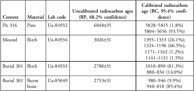
A birch charcoal sample taken from the edge of the monument under the bottommost layer of the cobblestone pavement indicates an earliest possible date for the monument of 3026±31 BP (Ua-84934; Table 1), which is at the transition between Montelius’ Bronze Age Period II (1500–1300 BC) and III (1300–1100 BC). The calibrated age provides an estimate of 1375–1223 cal BC (at 68.3% confidence).
Retrieved radiocarbon ages.

Table 1 Long description
A table with four rows and five columns comparing radiocarbon ages of different materials from various contexts. The columns are labeled Context, Material, Lab code, Uncalibrated radiocarbon ages (BP, 68.2% confidence), and Calibrated radiocarbon age (BC, 95.4% confidence). Row 1: Context, Pit 316; Material, Pine; Lab code, Ua-84932; Uncalibrated radiocarbon ages, 6848±35; Calibrated radiocarbon age, 5828–5815 (1.8%), 5804–5656 (93.5%). Row 2: Context, Mound; Material, Birch; Lab code, Ua-84934; Uncalibrated radiocarbon ages, 3026±31; Calibrated radiocarbon age, 1395–1333 (26.1%), 1324–1196 (66.5%), 1171–1162 (1.2%), 1141–1131 (1.5%). Row 3: Context, Burial 301; Material, Birch; Lab code, Ua-84933; Uncalibrated radiocarbon ages, 2788±31; Calibrated radiocarbon age, 1010–890 (81.3%), 880–834 (14.0%). Row 4: Context, Burial 301; Material, Burnt bone; Lab code, Ua-85049; Uncalibrated radiocarbon ages, 2753±31; Calibrated radiocarbon age, 980–946 (9.9%), 940–818 (85.4%).
Calibration was done with IOSACal v.0.4. with atmospheric data from Reimer et al. (Reference Reimer2020).
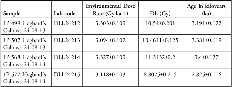
However, the mound cannot be securely dated using radiocarbon evidence alone, as residual charcoal from earlier activity is a well-known issue in such depositional contexts; radiocarbon determinations may not directly reflect the timing of mound construction if older organic material was incorporated into the deposit. To address this limitation, we also undertook optically stimulated luminescence (OSL) dating (Table 2; see also OSM1–3). Four samples were collected from the sandy sediments underlying the cobble pavement (see OSM1). These sediments represent redeposited glaciofluvial material which, although substantially older than the monument, were likely exposed to sunlight during mound construction, leading to signal bleaching and resetting of the OSL clock. The improved accuracy afforded by OSL dating, when combined with the radiocarbon results, enhances chronological resolution and allows the construction of the mound to be constrained more precisely (Bailiff et al. Reference Bailiff2024).
Burial doses (Db), environmental dose rates and ages for the analysed samples.

Table 2 Long description
The table presents data on burial doses (Db), environmental dose rates, and ages for analyzed samples. It consists of four rows and four columns. The columns are labeled Sample, Lab code, Environmental Dose Rate (Gy.ka-1), Age in kilo-years (ka). The rows provide specific data for each sample. Row 1: Sample: 1P-499 Hagbard’s gallow 24-08-13, Lab code: DLL24212, Environmental Dose Rate: 3.303±0.109, Age in kilo-years: 3.191±0.122. Row 2: Sample: 1P-507 Hagbard’s gallow 24-08-13, Lab code: DLL24213, Environmental Dose Rate: 3.094±0.102, Age in kilo-years: 3.381±0.119. Row 3: Sample: 1P-568 Hagbard’s gallow 24-08-14, Lab code: DLL24214, Environmental Dose Rate: 3.327±0.109, Age in kilo-years: 3.4±0.127. Row 4: Sample: 1P-577 Hagbard’s gallow 24-08-14, Lab code: DLL24215, Environmental Dose Rate: 3.118±0.103, Age in kilo-years: 2.825±0.116. The table provides detailed information on the environmental dose rates and ages of different samples, allowing for comparisons and analysis of the data.
The measurements were done on quartz 7mm multigrain aliquots, each containing approximately 1250 grains. Db was extracted from the De values using the Average Dose Model. The dose rates are corrected using water content, grain size and etch attenuation factors (see OSM2 for details).
Three of the four OSL samples returned dates within the range 3.4–3.2 ka (thousand years ago; Table 2), corresponding to c. 1400–1200 BC. These are in broad agreement with the radiocarbon determination from the base of the mound (1375–1223 cal BC at 68.3% confidence; see OSM2 & 3). This concordance supports the interpretation that the birch charcoal is not residual but broadly contemporaneous with the construction of the mound. A key advantage of OSL dating in this context is that the sampled sediments can be directly linked to the construction event itself even though the time span is comparatively longer than the radiocarbon range. On this basis, the radiocarbon age can be confidently associated with the building of the monument. Thus, the combined results of OSL and radiocarbon dating indicate that the mound was constructed 1400–1200 BC.
Further trenches were opened adjacent to the excavated mound. One of these contained the cremated remains of a 10-year-old child placed within an urn. Two radiocarbon dates obtained from burnt birch and burnt bone date this burial to between approximately 1000 and 800 cal BC (Burial 301, see Table 1). Another charcoal sample from a nearby pit produced a Mesolithic date (Pit 316, see Table 1).
Conclusion
Through working with small-scale excavations and in combining chronometric techniques, the project has revealed a firm dating for the foundation of the mound in which two of the monumental standing stones are set. This date, 1400–1200 BC, precedes the tentative date suggested for the rock art that decorates one of these standing stones (1100–900 BC; Skoglund et al. Reference Skoglund2025), indicating possible construction in at least two chronological phases. Excavations have further revealed that additional activities such as burials took place in relation to the visible monuments. The excavated urn burial produced a similar age to the rock art, while the mound seems to be older. The project is thus demonstrating that the monument has a far more complex biography than previously recognised.
Acknowledgement
We are grateful to Asige Historical Society for their generous support throughout this project.
Funding statement
The project ‘Hagbard’s Gallows and the Bronze Age cultural landscape’ is financed by the Lennart J. Hägglund Foundation for Archaeological Research and Education. The OSL work received support from the Leverhulme Trust (Research Grant RPG-2023-291).
Online supplementary material (OSM)
To view supplementary material for this article, please visit https://doi.org/10.15184/aqy.2026.10426 and select the supplementary materials tab.




 Open access

