Introduction
Despite a considerable emphasis on mobility in archaeology, recent research has tended to focus disproportionately on migration as revealed through ancient DNA and isotope analysis, while smaller, human-scale movements—specifically along routeways—are mostly ignored. Evidence for past trackways in Britain is extensive but fragmentary, dispersed and difficult to interpret. Some tracks, such as holloways, were created by the erosion of traffic; they are negative features without fill, and hence difficult to date. The challenges of identifying past routeways have often been emphasised, and, consequently, there has been a tendency to focus on the fixed and more tangible elements of the past, on ‘places’ rather than mobility to, from and around them.
Concentrating on sites, however, removes the physical evidence of bodily movement from the discourse, and imposes a ‘stillness’ on the past. Even when the movement of people or objects is identified, it is the ‘places’ that are highlighted rather than the patterns of connectivity through which past communities encountered, perceived and contributed to the construction of the landscape. If we do not look at paths and people's movements along them, we miss the action—the real life. Life unfolds, says Ingold (Reference Ingold2011: 148), “not in places but along paths”. By shifting our focus to routeways, and mobility more generally, we can begin to re-animate the past.
The social, political and cultural aspects of movement along routeways are also frequently overlooked in archaeology (Leary Reference Leary and Leary2014, Reference Learyin press). Mobility is imbued with significance and meaning, and a constellation of messages is communicated through movement. It can represent freedom and opportunity, just as it can be a form of control or, conversely, a way of resisting authority. Some movements are unrestricted, others bounded; some are difficult, requiring exertion, and others are easy. Some people and groups conform to socially acceptable levels of mobility and others do not; the latter, for example, include Romany and Traveller groups whose movements may be regarded as something to be controlled.
Inequalities of power within society often determine different levels of mobility, for example, according to gender or the dependency of children and those of impaired mobility on others. Through inequalities of mobility and status, individuals gain access to different spaces (Cresswell Reference Cresswell2006; Urry Reference Urry2007; Adey Reference Adey2010). Although there have been some recent perceptive investigations of mobility (e.g. Chadwick Reference Chadwick2016), discussion of the topic in archaeological literature often remains frustratingly rational and abstracted from the actual experience of movement, especially in relation to prehistory. Movement is often framed through the lens of cost and benefit, with strategies seen as logically chosen for their functional practicalities, rendering movement an involuntary and behavioural reaction (Ingold Reference Ingold2004, Reference Ingold2011).
Mobility is so natural and pervasive as to appear self-evident. Here, however, we argue for the need to re-focus our view of the past away from static places and sites to movement and mobility, and to develop an approach with a greater emphasis on patterns of connectivity. This could be called a ‘mobile archaeology’ or a ‘kinaesthetic archaeology’, and illuminates the most ubiquitous, and probably the earliest, way in which people structure and comprehend landscape through the movement of their bodies. Habitual routes of movement are a critical element of niche construction—the process whereby organisms modify their own and each other's niches (Olding-Smee et al. Reference Olding-Smee, Laland and Feldman2003). The study of patterns of movement is important, achievable and relevant to every part of the world and to all periods.
False paths
One factor that helps to explain why research has neglected movement and trackways for so long, at least in Britain, is Alfred Watkins's The old straight track (Reference Watkins2014 [1925]). Watkins was an amateur archaeologist, and while his book was based on his native Herefordshire countryside and reflects his love and empathy for that landscape, its conclusion was entirely erroneous (Bell Reference Bell2020). He observed that some historic (and prehistoric) places could be joined by straight lines, which he called ley lines. These he regarded as ancient communication or trading routes. His argument was, however, fatally undermined by the varied characters and dates of the sites involved, and the special pleading and unsubstantiated claims that permeate the work. The monuments include Neolithic and Bronze Age barrows, prehistoric settlements, boundary and waymark stones, Christian churches, medieval moated sites, avenues of trees, even isolated pines, along with many other features. The ley lines, Watkins proposed, went up hill and down dale with no reference to topographic barriers. He rationalised the inclusion of sites of widely different dates by arguing that, for instance, Christian churches were built on previously significant sites. Why this logic should apply to some sites and not others, however, was not explained. Suffice to say, there is no convincing evidence for Watkins's ancient ley routes.
With The old straight track, Watkins opened the countryside to the popular imagination, and his ideas provoked widespread interest. To this day, his ideas are elaborated in a host of New Age theories. One can only speculate as to whether Watkins's ideas would have proved so persistent had archaeologists in the 1920s engaged more actively in critique of them. The pioneering field archaeologist O.G.S. Crawford dismissed Watkins's theories (Hauser Reference Hauser2008), but refused to review The old straight track in the journal he edited, Antiquity. The first substantive critique of Watkins's ideas was not published until 58 years after the book's first edition; in it, Williamson and Bellamy (Reference Williamson and Bellamy1983) present a systematic demolition of ley lines and the subsequent New Age ideas that had built upon them.
Watkins's ideas were so significantly erroneous that they effectively poisoned the ground for research on routeways. Two pieces of evidence demonstrate the extent to which this occurred. For some 20 years before 1925, the study of prehistoric routeways was an active field, with some excellent empirically based field surveys conducted by pioneering archaeologists, including Williams-Freeman (Reference Williams-Freeman1915), Crawford (Reference Crawford1922), Curwen and Curwen (Reference Curwen and Curwen1923) and Fox (Reference Fox1923). After the publication of Watkins's book, this promising area of research essentially died. Instead, archaeologists like the Curwens focused on settlements, fields and burials. While they continued to note the existence of short lengths of trackway adjacent to settlements, after 1925 they seldom speculated as to how these related to wider communication patterns (Bell Reference Bell2020).
A second line of evidence for the toxic effect of Watkins's book is provided by comparison with continental Europe. Here, the pioneering studies of Müller (Reference Müller1904) were followed by a steady stream of archaeological research on past routeways, notably the work of Bakker (Reference Bakker1976) that draws on evidence for alignments of barrows and other monuments in the Low Countries, and later investigations of well-attested routeways from as early as the Neolithic in Denmark (Bang Reference Bang, Bergerbrant and Sabatini2013; Klassen Reference Klassen2014). As Bakker (Reference Bakker and Lichardus1991: 518) observes, in Britain, the phenomenon of roads marked by monuments is “regarded with scepticism and its study seems somewhat neglected”. The British archaeological literature does indeed exhibit signs of a marked scepticism towards the study of trackways. Taylor's (Reference Taylor1979: 1) pioneering study of roads and tracks, for example, noted on its first line the difficulty of investigating prehistoric routes, with all but a few being “impossible to date”. Coles (Reference Coles, Fenton and Stell1984: 1) observed that discussion of roads allows “the prehistorian to indulge in conjecture unencumbered by the need to pay attention to observable evidence”. Fowler (Reference Fowler, Everson and Williamson1998: 25) describes tracks as “the haunt of the romantic, the irrational and the obsessional”, while Bradley (Reference Bradley1997: 81) states that “the recognition of ancient roads or trackways is notoriously subjective, and all too often turns out to be based on circular argument”. Fleming (Reference Fleming2012) remarks that archaeologists have never felt completely comfortable with old roads, and the subject has been left to amateurs.
Perhaps the main lesson to take from Watkins (Reference Watkins2014 [1925]) is that, while a feel and empathy for the landscape is of great value, it is insufficient for an adequate appreciation of landscape origins. Detailed examination of individual features, the critique of ideas and interpretations, and the need to develop a robust chronology and interpretative frameworks remain its cornerstones. If we are to make any progress, we must consider the full range of evidence for past patterns of movement and develop a practical toolkit of approaches for application in the field and laboratory (Bell Reference Bell2020).
Steps forward
The pessimistic views presented above reflect the general position of 20 or 30 years ago. Only now are our field activities catching up, and this is partly due to the huge scale of some landscape excavations, and because we can now deploy a far wider array of absolute dating techniques, including radiocarbon, dendrochronology, optically stimulated luminescence and uranium-series dating. Routeways can therefore be investigated with a range of scientific approaches, making it possible to achieve an understanding of movement in the landscape that seemed out of reach a generation ago.
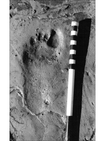
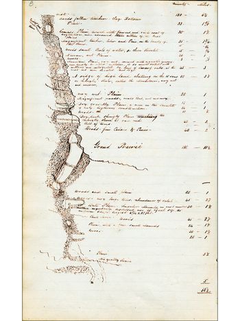
Progress requires a conceptual shift from our focus on sites to adopting a far wider landscape perspective. The study of routeways cannot be limited to one period or to a local scale; it is necessarily multi-period and multi-scalar, from individual footprint-tracks (Figure 1; Bell Reference Bell2007) to long-distance routes. Environmental archaeology, for instance, has often been site-based. Now, as the density of investigated sites increases, it has become possible to develop a spatially broader view derived from multiple environmental sequences in a given area, as demonstrated, for example, by reconstructions of environmental change around Stonehenge and Avebury (Allen Reference Allen, Brown, Field and McOmish2005). What has been inadequately considered is that landscapes will, at least partly, be structured by linear patterns of movement between sites, and environmental disturbance will be concentrated along routes frequented by animals and humans. Figure 2 shows an example of a mid nineteenth-century map of a routeway in what today is Washington State, USA. The map is marked by a chain of small prairies within the forest, which, in a classic example of niche construction, First Nations communities burnt as they moved along the route, creating openings and woodland-edge habitats that could provide resources on future journeys (Leopold & Boyd Reference Leopold, Boyd and Boyd1999; Bell Reference Bell2020). Evidence for such activity in the past could be obtained from vegetation patterns, non-pollen palynomorphs, geochemical analysis and sedimentary DNA (Bell Reference Bell2020: 5).
Mesolithic footprint of an 8–9-year-old child from intertidal sediments at Goldcliff, Wales (Bell Reference Bell2007: fig. 12.7; photograph by E. Sacre).

Map made in 1840 by James Douglas of the Hudson Bay Company, showing a chain of prairies along the route from the Cowlitz Plain to the Nisqually River, today part of Washington State in the USA (map A/B/40/D75.2, courtesy of the Royal BC Museum and Archives, British Columbia, Canada).

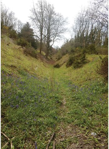
There is also a need for research-led excavations aimed specifically at establishing the date and character of past routeways. Some cases most in need of attention include: droveways connecting uplands and lowlands, wetland and dry ground, and those associated with surviving coaxial patterns; routes associated with prehistoric bridges; possible routeways linking Late Iron Age oppida; and tracks connecting terrestrial, riverine or marine transport. Dating can be achieved by developing a geoarchaeological approach focused on the sedimentary context of routeways and the composite landforms that they often represent; an approach that could be called ‘archaeogeomorphology’. In agricultural landscapes, field investigation shows that holloways (Figure 3) are often not simply negative erosive features, but have datable positive lynchets marked by relatively level benches running along their upslope flanks, and negative lynchets along their downslope edges. At Lyminge in Kent, for example, dating of a flanking positive lynchet using multiple techniques (i.e. optically stimulated luminescence, artefacts, the dates at which various species of molluscs were introduced and uranium-series dating of land mollusc shells) demonstrates that its holloway is of at least Romano-British, and probably earlier, origin (Bell et al. Reference Bell, Black, Maslin and Toms2020).
A deeply incised holloway on the South Downs escarpment at Saddlescombe, East Sussex; this route seems to have originated in the Iron Age (Bell Reference Bell2020: 225–29; photograph by M. Bell).

Trackways have been more intensively studied in wetland contexts (Brunning & McDermott Reference Brunning, McDermott, Menotti and O’ Sullivan2013), although their continuation onto dryland has seldom been considered. Exceptions are the Corlea 1 trackway in Ireland, which Raftery (Reference Raftery1990) suggested may have been part of a much longer route linking ceremonial centres, and trackways at Smilde in the Netherlands, which seem to form part of longer routes along sand ridges (Casparie Reference Casparie1987). The relationships between dryland routes and those involving rivers and seas also require further investigation (Haughey Reference Haughey, Menotti and O'Sullivan2013), as many dryland routes may only make sense when seen as parts of patterns of movement undertaken by boat. Important river routes, such as along the Wiltshire Avon, can be postulated (Sherratt Reference Sherratt1996). These are sometimes supported by artefact distributions, which have recently led to the identification of maritime landing and trading places (Bradley et al. Reference Bradley, Rogers, Sturt and Watson2016).
Furthermore, archaeologists need to work across periods. Ridgeways and prehistoric routeways have received relatively little attention compared to Roman roads. The latter are well studied but often in isolation and without serious focus on the opportunities that their spatial relationships offer for establishing a chronology. Ridgeways and other ‘natural’ routes should, however, only be accepted as such when they are substantiated by other forms of evidence for their use in the period in question. Although ridgeways have often been regarded as the main long-term routes of prehistoric movement in lowland England, Taylor's (Reference Taylor1979) field investigations showed that evidence for use of the so-called Jurassic Ridgeway (a ridge that stretches across England from the south-west through the Cotswolds northwards to Lincolnshire) was extremely weak. Other examples, such as the Wiltshire-Oxfordshire Ridgeway, may be a little more convincing, but even here the routes seem to post-date the Bronze Age (Miles et al. Reference Miles, Palmer, Lock, Gosden and Cromarty2003). Excavation of the Pilgrim's Way along the high-speed rail route at Whitehorse Stone in Kent appears to suggest a post-Roman date (Booth et al. Reference Booth, Champion, Foreman, Garwood, Glass, Munby and Reynolds2011).
A contention of this article is that, in order to overcome the problems of investigating past routeways, we must integrate the perspectives provided by both social theory and the sciences. At times, these two approaches seem to have been in opposition (Bell Reference Bell2020). Integration may, in part, be achieved by following up perspectives provided by phenomenological approaches (Tilley Reference Tilley1994), using detailed field investigation concerning the dates and characters of routeways. A topic that would particularly benefit from this integrated approach, including the scrutiny of historical sources, is the origin of droveways. In the UK, they have often been considered to be medieval, but growing evidence from areas such as the Weald of south-eastern England indicates that some had prehistoric origins (Bell Reference Bell2020).
Roads and routeways were, and still are, social spaces that channelled diverse groups of people, which allowed them to socialise as they moved. As Evans (Reference Evans2003) has pointed out, movement along routes used for transhumance brought together individuals of different ages and genders. Being less frequent than routine everyday movement and often in more distant areas, transhumance was somewhat removed from daily life. Strangers could find themselves spending time together, and such transient meetings would facilitate the exchange of information, genes and objects. Ideas surrounding status and wealth could be explored during these encounters; rivalries and squabbles over animals or common land could be resolved, while new friendships and relationships beyond the household and immediate community could be forged. The locations where such meetings took place—particularly the crossing-places of long-established, distant routes—probably acquired a special status over time. This may account for the reuse of Mesolithic sites by Neolithic tombs, or the creation of the Avebury henge where two tracks, implied by two pairs of opposed entrances, crossed at an established grassland clearing (Bell Reference Bell2020). Movement along routeways thus broadened the social realm. Far from being static, passive spaces, these routeways were the very essence of life (Leary Reference Leary and Leary2014, Reference Learyin press).
The journey begins
Routeways connect people. They are mobile gathering places that we inhabit in motion. They are designed for movement and are places of physical mobility, nodes of aspiration and the connectors of different spaces and distant lands. They are more than simply functional marks on the landscape, routeways shape how travellers think, perceive and interact with the world around them. They create certain views that structure how a person or community understands its surroundings. Despite their obvious association with movement, when viewed through the lens of history or archaeology, paths, tracks and roads tend to be seen as passive. Yet they are anything but passive; they act on people as much as people act on them. They have agency, they structure our lives and form a critical part of our lived space. Roads are not separate from the landscape, they are not a foreign intrusion into it, but are a continuum woven within its fabric. Far from being a human intrusion into the natural landscape, roads grow organically from within it.
An archaeology of mobilities can link science with social science, and encompasses different scales from small-scale movement to long-distance travel and migration involving the movement of people, objects and ideas. A mobile archaeology also embraces the differential politics of mobility.
Compared with many other aspects of archaeology, trackways and associated mobility have long been neglected, and this can be explained by the influence of Watkins's The old straight track. New strands of evidence, gained through interdisciplinary studies, however, can help chart a way forward, and we offer here the first steps towards a positive approach to interpreting past mobility.