The exploration of ancient landscapes and memory has challenged and excited archaeologists in recent years. Layton and Ucko (Reference Layton, Ucko, Ucko and Layton1999) summarize the range of conceptualization of landscape from the phenomenological emphasis on natural setting to the ideational emphasis on perception, meaning, and belief. Likewise, Ashmore and Knapp (Reference Ashmore and Knapp1999) explore the conceptualized and constructed aspects of ancient landscapes. I view the range of landscape conceptualization as encompassing scientific (physical and social science) through humanistic approaches, although archaeological emphasis has shifted recently from the former more toward the latter (Ashmore and Knapp Reference Ashmore and Knapp1999). It is this upsurge of humanistic approaches in archaeology that emphasizes the affective, perceptual, and experiential dimensions of landscape. Yet I agree with Layton and Ucko (Reference Layton, Ucko, Ucko and Layton1999) that employing the full range of scholarship from science to humanism can be very useful. Thus we can see the landscape as environment, and paying attention to topography, rainforest resources, soils, water, and sources for stone tools, while seeing the landscape as social space, paying attention to repeated activities that become deeply embedded in social memory. Humanistic insights, ideas, and speculations can generate controversy, often leading to testable hypotheses and further research.
Connerton (Reference Connerton1989) explored how traditional societies incorporate practices over many generations. Ritual performances such as linear processions to access ancestral spirits provide a good example. Archaeologists have rarely encountered evidence of pilgrimages, as occasional pilgrimages would leave little in the way of physical remains. However, in this case our use of remote sensing instrument systems and detailed stratigraphic recording and interpretation has detected centuries of pilgrimages across almost two millennia. The recent book El Pueblo del Señor: Las Fiestas y Peregrinaciones de Chalma (Shadow and Rodriguez-Shadow Reference Shadow and Rodriguez-Shadow2000) could provide an ethnographic inspiration for future explorations of ancient pilgrimages. Ethnographic accounts of funerary practices and beliefs among traditional Native people in lower Central America provide possible clues to ancient behavior and perceptions in a symbolically charged environment.
In this article I explore how ancient Costa Rican cemeteries were first established about 2,500 years ago as special places at considerable distances from villages, breaking dramatically from the past tradition of burial adjacent to each individual household. That separation represented a new formulation of social memory, which persisted for well over a millennium, as recorded in entrenched ritual pathways. The cultural prescription of single-file procession along precisely the same path began literally entrenching the path into the landscape as well as into social memory. As people walked the same path, that path surface compacted into a linear hollow, which began eroding and entrenching where it traversed sloping surfaces. I use the ancient Cañales village as an example of what was likely happening regionally.
I begin by reviewing the work of the Arenal Research Project that I have directed since the 1980s in northwestern Costa Rica. This project found that secondary burial practices within households occurred for approximately 1,500 years before a switch to primary burials in distant village cemeteries, which lasted for approximately the same duration. The Cañales village was occupied during both of those periods. Detailed study of the Cañales site has provided new insights into human behavior and social memory in the area. I originally interpreted the repeated reoccupation of the Cañales village after natural disasters caused by explosive eruptions of Arenal Volcano as contingent upon ecological recovery during the earlier stages of our research (Sheets Reference Sheets, Sheets and McKee1994). While those are still important factors and should not be subordinated or ignored, I believe that a primary motivation for reoccupation of the village was to reinstate path use to the cemetery to reconnect with the spirits of deceased ancestors.
The chronological phases used in this article include the Tronadora phase (2000–500 b.c.), the Arenal phase (500 b.c.– a.d. 600), and the Silencio phase (a.d. 600–1300) (Sheets Reference Sheets, Sheets and McKee1994). Radiocarbon dating, comparative analyses of artifacts, and especially ceramics (Hoopes Reference Hoopes, Sheets and McKee1994a, Reference Hoopes1994b) are the bases for identifying and dating the phases. Based on recent work by Juan Vicente Guerrero, the Arenal-Silencio boundary may have to be moved to a.d. 300, and the Silencio phase may have ended about a.d. 900 (Sheets Reference Sheets2003).
THE ARENAL RESEARCH PROJECT
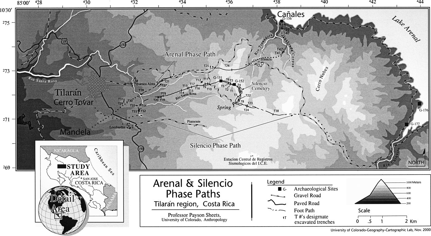
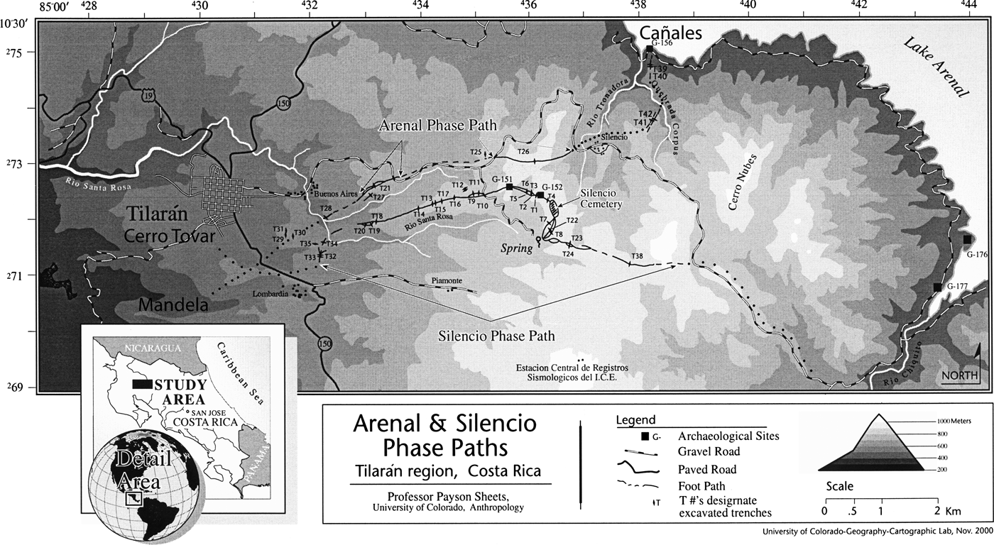
The Lake Arenal area (Figure 1) was occupied in Paleoindian times, as evidenced by the Clovis-style projectile point found during survey of the southern shore (Sheets Reference Sheets, Sheets and McKee1994). It was also occupied during the Archaic, as indicated by radiocarbon-dated campsites and associated artifacts. Not surprisingly, we find no evidence of sedentary or semi-sedentary habitations in either of these early time periods. It is likely that “membership” in a mobile band was flexible, and presumably people had some sense of place regarding loci useful in collecting, hunting, and gathering of non-domesticated food sources, as well as a short-term sense of place in the campsite with its temporary hearth and activity areas. As Ashmore and Knapp (Reference Ashmore and Knapp1999:10) state, “mobile human groups create their landscapes by projecting ideas and emotions onto the world as they find it—on trails, views, campsites or other special places. Sedentary people, on the other hand, structure their landscapes more obtrusively, physically constructing gardens, houses and villages on the land….” Although we have no direct evidence, a few cultigens probably were part of the diet at least toward the end of the Archaic. We have definitive evidence of cultigens for all later phases, but it appears they remained a small fraction of the diet during pre-Columbian times. Burial practices related to settlements form key elements to this article. Project researchers have excavated fairly extensively in three Arenal phase cemeteries and one Silencio phase cemetery.
Arenal research area, northwestern Costa Rica. The Cañales village is on the southern lakeshore at upper right, and its cemetery at “Mandela,” lower left, a dozen kilometers away. They are connected by the ancient processional pathway.
The Tronadora Phase
During the Tronadora phase (2000–500 b.c., but perhaps beginning before 3000 b.c.), village sites were established in the area (Bradley Reference Bradley, Sheets and McKee1994). We found a total of 24 village sites around the Lake Arenal shore and along drainages emptying into the lake (Mueller Reference Mueller, Sheets and McKee1994:55). Pole and presumably thatch-roofed houses were large and circular, averaging about 5 m in diameter. The lithic technology was expedient, with each household obtaining their own raw materials and making their own percussion flake cutting tools. Ceramics (Hoopes Reference Hoopes, Sheets and McKee1994a, Reference Hoopes1994b) were sophisticated, with painted and plastic decoration, and their abundance indicates a greater degree of sedentism than before, although not as developed as what emerges in the following Arenal phase. Secondary burials may have been interred within villages by digging narrow trenches adjacent to each house. No stone was found in grave construction. It is important to note that burials were not in cemeteries, but may have been per household. Thus, village life was at least semi-sedentary, with individual households maintaining a high degree of economic autonomy. We have no evidence of communal facilities or social cohesion on the village level during this early phase. That autonomy may have extended into social, political, and religious matters as well.
Consideration of the sense of place is appropriate here. Although we found only a few sites dating to the earlier Fortuna phase (approximately 7000–3000/2000 b.c.), the Archaic hunter-gatherers probably were developing senses of places such as sacred loci, perhaps similar to those reported by Ucko and Layton (Reference Ucko and Layton1999). I do think a different sense of place must have been developing during this phase, especially because deceased ancestors may have been buried adjacent to the house. People may have been differentiating their households from the outside world. At any rate, at this time the sense of place probably was more strongly focused on the individual household than the village. The sense of place likely was more longitudinal, linking deceased ancestors below the house, and presumably their spirits, up to the living residents, and perhaps farther upward into the heavens into the spirit world. The picture we get is a high degree of individual household independence within the settlement. It is likely that some social accommodations needed to be made, given the greater proximity of other people in the village. I suggest it is worth considering these early villages as seasonally-compressed late Archaic lifestyles rather than a sudden burst of formative sedentary settlements that qualitatively revolutionized society and habitation. Archaic artifacts were found below the Tronadora phase occupation at Tronadora Vieja, perhaps indicating an intensifying sense of place, and continuity. Settlement may well have been semi-sedentary. Now let us focus on a particular village occupied during this early Tronadora phase, and then witness the dramatic changes during the Arenal phase that followed it.
The Cañales Village Site (G-156)
The Cañales village was first established by 2000 b.c. on the south shore of Lake Arenal at an elevation of 540 m asl. Ceramic and stratigraphic evidence tie the site to the stratigraphic and robust radiocarbon chronology of the nearby Tronadora Vieja site (Bradley Reference Bradley, Sheets and McKee1994; Hoopes Reference Hoopes, Sheets and McKee1994a, Reference Hoopes1994b). Two of the calibrated C14 dates at Tronadora Vieja are older than 3000 b.c. suggesting that the antecedents of these early villages with their sophisticated ceramics may have been founded over a millennium earlier than 2000 b.c.
Cañales and other early Tronadora phase villages had low artifact densities (Hoopes Reference Hoopes1994b), and appear to have been quite dispersed, with individual households maintaining large open spaces between them. We documented the maximum extent of the site at 440 m east-west. We do not know the north-south dimension, as the northern end was inundated by the expanding lake after the construction of the Sangregado dam in the early 1980s. The southern boundary is still buried by volcanic ash, and thus fortunately preserved for future research. By Mesoamerican standards the habitation residues we found within that swath were sparse, but they were moderately abundant by Costa Rican standards, suggesting perhaps a village population at most times between a few dozen to perhaps a hundred people. Mean annual precipitation here is about 3,000 mm with negligible seasonality, producing a tropical rainforest of high biomass and very high biodiversity, providing abundant wild, natural foods.
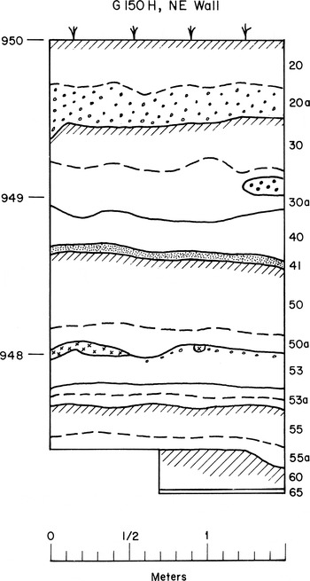
Village occupation appears to have been rather stable during the Tronadora phase, with two notable exceptions. Two large explosive eruptions of Arenal Volcano, one early and one late in the phase, resulted in substantial volcanic ash falls at the site. Each ash fall (tephra deposit) is identified as a Unit, and numbered sequentially with the larger numbers at the bottom (Melson Reference Melson, Sheets and McKee1994). The two eruptions deposited Units 61 and 55 over the village (see Figure 2). Unit 61 is the earliest, stratigraphically lowermost, tephra, which could have emanated from Cerro Chato (Hoopes Reference Hoopes1994b). Each would have been about a meter or more in thickness and had major ecological effects that must have caused the village to be abandoned for at least a few years, and perhaps decades. Richardson Gill (personal communication 2009) favors the shorter time of abandonment, as he noted a rather rapid re-establishment of a village only a few years after the eruption of El Chichon Volcano in Mexico. Most people could have survived the tephra, especially if they had something such as clothing to cover their faces to assist in breathing. Yet presumably they would have had to rapidly evacuate to loci many kilometers away. The ecological effects would have included fine particulate contamination of water that would have clogged the gills of fish, thus eliminating a rich source of protein. The sulfur dioxide in the eruptive clouds combines with moisture to form hydrosulfuric and sulfuric acids, further contaminating water as well as the moist lining of the lungs of air breathing animals. For people who had successfully adapted to the rich biodiversity and high biomass of the tropical rainforest, with some horticulture, the impact of these great explosive eruptions is hard to exaggerate. Their tropical rainforest environmental abundance was changed overnight into a sterile lifeless desert, and the people who survived the eruption would quickly perceive the benefits of being elsewhere. One can only guess about the death rate/survival rate of people with more than a meter of fine-grained tephra falling in the air. The death rate of vegetation would have been virtually total, with only a few scattered large trees surviving.
Stratigraphy on hilltop near the Silencio cemetery, away from archaeological sites. Tephra units identified along right margin. Unit 52 is preserved only on the left, at the 948 m level, marked with small x's. Note abrupt contacts of volcanic ash and soil units. Well-developed A horizon soils are identified with hachure, and tephra units containing pumice particles with small o's. Unit 61 was not identifiable at this location, but at other loci it was preserved above Unit 65, and below Unit 55.

Population densities in the Arenal area during all the pre-Columbian phases were low, just a few people per square kilometer, and thus well below carrying capacities. The contrast with many areas in lower Central America is striking, and even more dramatic with the dozens to hundreds of people per square kilometer in Mesoamerica. Perhaps an unanticipated benefit of low population densities, and the absence of hostilities, is that evacuees could more readily find suitable refuge in the Arenal area. Also, the high proportion of dietary dependence on non-domesticated vegetative resources would facilitate a sudden relocation. Each eruption was followed by quiescence of approximately 11 and 6 centuries respectively, sufficient to develop a very thick, rich A horizon soil.
In earlier research my theoretical framework for ancient human decision-making regarding resettlement was ecological, meaning that people would return when soils had recovered sufficiently to support a re-emergent rainforest, and some horticulture (Sheets Reference Sheets, Sheets and McKee1994). Yet understanding whether the re-occupants were the descendants of the pre-disaster villagers was difficult. Because of the generalized regional similarities in artifacts, architecture, and village layout, we were unable to answer that question. Only recently, when we began “thinking outside the site” and using different theoretical/interpretive perspectives did we perceive an answer.
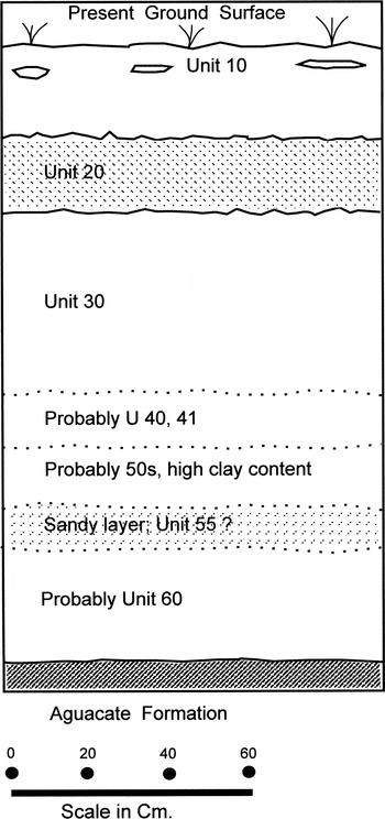
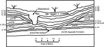
A crucial element in looking for that answer was good chronological control of human activities, and particularly a detailed stratigraphic record. We repeatedly made the same mistake, of looking closely at the stratigraphy within each site to try to understand relationships. Finally, we learned that the worst stratigraphic records were consistently those within sites. The strata illustrated in Figure 3 provide an example. The stratigraphic profile is a meter and a half thick, covering the last four millennia, but the identifiable strata are few indeed. Only two tephra units can be identified with confidence, and both occurred during the last 600 years, well after our time of interest. Four other tephra units could be identified only on a “probable” basis, and none had an abrupt contact at top or bottom. The reasons are that the combination of bioturbation, human disturbance (anthroturbation), and possibly anthrosol formation all end up “homogenizing” strata. By recording stratigraphy within dozens of sites, and more importantly at dozens of localities well outside of sites, we have learned that the latter consistently give us a more complete record. Thus in this article I will use the superior stratigraphic record in a 3 km radius outside the site to clarify the blended stratigraphy within the site. The contrast with the stratigraphy preserved outside the site, recorded in trenches across the path, is striking. Outside of the site one can clearly identify seven tephra units, and the contacts are consistently abrupt and thus can be drawn with a line (Figure 4).

Stratigraphy just outside Cañales village, at Trench 26, along the path to their cemetery. Not one of these abrupt stratigraphic contacts could be identified within the village, as shown in Figure 3. Outside the village very clear stratigraphic relationships reveal the timing and nature of ritual path processions to the cemetery in the Mandela area across the Continental Divide.

The Arenal Phase (500 b.c.–a.d. 600) and the Cañales Village
The Arenal phase witnessed increased size and sedentism of villages, shared activities, and a markedly greater sense of place manifested on the landscape by the establishment of long-distance ritual pathways between villages and distant cemeteries. I suspect the villager's changing sense of place recognized the entity of the village as an interacting series of households that was greater than the sum of its parts. The cooperative activities that took place in cemeteries further promoted solidarity linked to sacred space. Those activities included feasting, rituals, and perhaps construction projects that were performed in the Arenal phase, and became particularly elaborate in the later Silencio phase. Ethnographic analogies (discussed below) aid in inferring meaning in the creation of and participation in these cemeteries and precise single-file processional paths, the most dramatic change in pre-Columbian northwestern Costa Rican burial customs. People were sinking deeper social roots and simultaneously establishing processional routes, materializing a communal identity. These pilgrimage routes precisely followed the same paths for centuries, and the sustained use resulted in erosional emplacements. The details of why and how this occurred are unknown, but it must have been some kind of compelling religious change on a regional scale, or a greatly enhanced belief in the power of the spirits of deceased ancestors.
In many areas of Costa Rica people began to use large amounts of subrounded river rock to build up mounds over primary interments. The Bolivar site provided abundant evidence of rituals and feasting on the river rock mound (Hoopes and Chenault Reference Hoopes, Chenault, Sheets and McKee1994). These activities continued throughout the Arenal phase. It would be tempting to interpret these visually impressive mounds of rock with their multiple interments as indicative of centralized authority. However, I suggest the mounds at least in our research area may have been accretional over many generations to centuries, resulting from households burying their dead within the same graveyard, and expanding the cemetery incrementally upward and/or outward with each interment (Butler Reference Butler2003). Had the mounds been built in a short time, such as a generation, the deep entrenchment of the paths would not have occurred. Such a significant religious change could signify the arrival of a new cultural group, or the beliefs could have arisen and/or flourished within the same group. I favor the latter due to a considerable degree of continuity in architecture and artifacts.
The distances separating cemetery from village in our research area range from a few hundred meters to a dozen kilometers. Cañales residents began burying their dead 11 km (straight line map distance) west-southwest of their village. The excavated processional path was very narrow, indicating single-file use by ritual participants. In map view, the overall route and most path sections are exceptionally straight. Yet map-view straight-line conceptualizing is misleading, as the path rises from the village at 540 m asl in elevation up over the continental divide at 970 m asl and descends on the Pacific side into the complex of cemeteries at an average elevation of 500 m asl. As it traverses these marked elevation changes the path heads directly down and up very steep slopes up to 40°, and crosses numerous ravines and streams. In a few notable cases, path segments followed gentle, uniform curves that had nothing to do with topography; the reason(s) for the deviation from straight segments must have been important, but is unknown. In many cases the path divides into two or three parallel segments. When a segment of a path eroded down through all the Arenal tephra layers to the “Aguacate formation” (Melson Reference Melson, Sheets and McKee1994), its heavy clay makeup would have made slopes difficult to traverse, especially when wet. People also would have had trouble walking up or down the steep slopes, so relocating a path segment a few meters to one side or the other would likely have been a reasonable solution.
It is not known if every deceased individual from Cañales was buried in this cemetery, but it is possible, as no other cemeteries were found along the procession way. If only certain individuals were buried at such a distance, their role (perhaps as diviners or people with particularly powerful spirits) may have influenced their burial spot.
A methodological note is appropriate here. We use remote sensing to detect linear anomalies, of which some are determined to be ancient paths. In particular, color infrared aerial photography provided by low-flying NASA research aircraft has been the most useful imagery, followed by commercial black-and-white aerial photography, then NASA true color air photos, and finally various digital sensors such as the Thermal Infrared Multispectral Scanner, Radar, and Light Detection and Ranging (LiDAR) (McKee and Sever Reference McKee, Sever, Sheets and McKee1994). More recently, the sub-meter resolution of satellites such as IKONOS has proven very useful. We have developed rigorous standards for field verification, by excavating trenches and dating erosion and deposition from cultural and natural processes (McKee et al. Reference McKee, Sever, Sheets, Sheets and McKee1994). The dozens of trenches we have excavated to confirm or deny a remote sensing anomaly as an ancient path consistently indicate the actual path surface was less than 1 m wide, and usually about .5 m wide (Figure 4), providing evidence for consistent single-file processions. As villagers followed the same path for years, the initial compaction and depression caused erosion in areas with slopes greater than about 5°, with greatly accelerated erosion where the path was inclined more than 15° or 20°. The angle of repose of sediments perpendicular to the path, on each side of the eroding trail, is only about 30° from horizontal because the sediments are so unconsolidated, resulting in a path that was entrenching itself and the adjoining sediments in a very broad “V” shape (Figure 4). A few centuries of use resulted in path entrenchment a few meters below the surrounding ground surface in steeper areas, and I believe a treasured cultural standard of the favored way to enter a special place by a deep path developed as an unanticipated result of these repeated practices. Those processions literally entrenched the procession ways into the landscape, and embedded into social memory the proper and ideal way to traverse the landscape, via the deep path with its long extent where vision of the landscape on either side is obscured, thus focusing attention on what lies ahead. When one enters a ceremonial special place it dramatically opens up to one's full visual field. Thus, the repeated walks to the cemetery and back literally and spiritually deepened the embeddedness and significance of the processions. After a major volcanic disaster, when people reoccupied the area and resumed processional path use, they mentally re-established their remembered landscape and access to the spirits of their deceased.
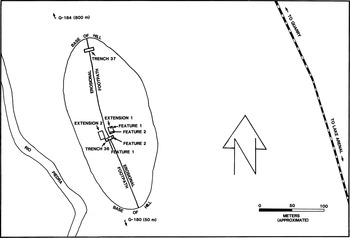
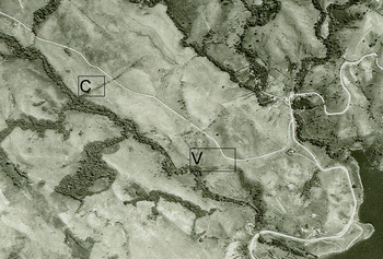
One case particularly underscores the importance of inscribed procession ways. Past the west end of Lake Arenal we discovered a village separated from their cemetery by about a kilometer (Figure 5). The easiest and most direct access to the cemetery would have been along a straight line following the gentle gradient of the Rio Piedra. But the villagers diverged from the straight line to go up a prominent hill, over the top, and down the other side, thus entrenching their single-file procession way on both sides (Figure 6). And they built stone platforms atop the hill, on either side of the path. The platforms look more like special features on which people stood, on either side of the procession, rather than shrines. Clearly the importance of having an entrenched procession way superseded a straight line and topographically easy access route between village and cemetery.
Map of hill between the village (immediately south of hill) and the cemetery (to the north), along the left bank of the Rio Piedra. Villagers went out of their way to walk up and over the hill, presumably so they could have an embedded procession way.

Aerial photo of Rio Piedra area, west of Lake Arenal. Lake Arenal at right. The village is immediately below the “V,” and the entrenched path up and over the hill is immediately northwest of the village. The cemetery is at “C.” The aerial photo field-of-view is approximately 2 km horizontal distance, east-to-west.

ROUTES AND ROOTS: PROCESSIONAL PATHS, SOCIAL MEMORY, AND VOLCANIC DISASTERS
The principal focus of this paper is human practice, belief, and their repercussions during the Arenal phase (500 b.c.–a.d. 600). By the dawn of the phase, the Unit 54 thick volcanic ash layer had been subjected to enough weathering and soil formation that vegetative and faunal recovery was presumably complete, and the Cañales village might have been reoccupied for perhaps a few generations before the dramatic change in burial location occurred. Because the religious transformation did not correlate with one of the big explosive eruptions, a natural event should not be considered as a contributing factor to that transformation. Further, the changes in mortuary practices occurred over such a widespread area of the Intermediate Area that Arenal volcanism certainly was not involved.
The Cañales village on the south shore of Lake Arenal may have been occupied for approximately three centuries before the next eruption occurred, obtaining their subsistence, lithic, and construction materials from nearby sources, and involving themselves in a rich social and ideological milieu of life. Generations of villagers walked the precise path more than 11 km to the cemetery to bury their dead, and to frequently revisit the graves. Of course, these visits involved respect for the deceased, and they must have involved getting in contact with the spirits of their ancestors. Although separated by considerable time and distance, ethnographic accounts of traditional Bribri indigenous groups in Costa Rica and Cuna groups in Panama describe the importance of separating village from cemetery, and the need to contact the spirits. The spirits of the dead appreciate being at a distance from the village so barking dogs and crying babies do not disturb them. Moreover, the villagers are not troubled by the proximity of spirits to their everyday lives. I suspect ancient cemeteries needed sustained spiritual sustenance, as perhaps did the households of the villages.
We can roughly estimate the depth of entrenchment that would have occurred over three centuries, so long as we remember these quantitative figures are only approximations. Based upon our overall estimate of the 1,100-year occupation of Cañales while the cemeteries existed, three centuries would represent 27% of use. That would indicate that the path at Trench 26 had entrenched only about 35 cm (27% of 130 cm). The slope is slight there; the total entrenchment in a steeper location a bit farther west is estimated at over 7 m, so at this time it would have entrenched an estimated 1.89 m, well over the heads of the people in procession. Thus the first centuries of repeated processional path use resulted in unintended landscape modification, steeper sections eroded sufficiently to create a new sensation of the surrounding terrain disappearing and the objective ahead coming into more clear mental focus. The trek to connect with the ancestors presumably attained a greater sense of history, as people saw and experienced the tangible result of their doing what their ancestors did, and maybe thinking this was the way it was always done. But then disaster struck again.
Arenal Volcano's next large explosive eruption was at about 200 b.c., and deposited a blanket of sterile volcanic ash (Unit 53A) (Figure 2) over the rainforest, small agricultural plots, rivers, and the lake. Melson (Reference Melson, Sheets and McKee1994:47) measured the thickness of what he identified as tephra from the same eruption at El Tajo, closer to the source, at 1.2 m. He estimates a diminution to 25% near Cañales, for an estimated depth of about 30 cm. Actually, these measurements are of tephra thicknesses in sections preserved today; original tephra depths prior to erosion and compaction would have been much greater, and therefore impacts proportionally more severe. That would be devastating for freshwater for drinking, for fish, and for smaller plants such as cultigens. Large trees could survive such an impact. Hence the impact was less than the earlier Unit 55 emplacement, but people would presumably have had to leave the area for sufficient time for the environment to recover. If the people who reoccupied the village were not related to the pre-eruption inhabitants, I think it is highly unlikely that they would reinstate use of the path to the village-associated cemetery in the Mandela area of the Pacific drainage. To us, it makes no sense that unrelated people would re-establish a path to someone else's cemetery and their spirits. Importantly, the old path would have been difficult to discern after the eruption because it would have largely filled in with the fresh tephra draping the entire countryside. The path leading westward from the edge of the village is on a gentle slope and would have been only slightly entrenched, and thus very difficult to detect unless someone already knew where it ran. It only would have been quite visible in steeper sections after the ash fall. The stratigraphic and path erosional data are clear, however, that the villagers resumed single file use of the same path right out of the village to the same distant cemetery, providing considerable evidence that the re-occupants were the direct descendants of the pre-eruption villagers. If reoccupation were rapid, many of the re-occupants could have been the original villagers themselves.
I would guess that resumption was within a decade or two, but we have no sufficiently detailed stratigraphic, artifactual, or chronometric data to support this. When we conducted the original research in the 1980s we framed it ecologically, that resettlement was principally based on environmental recovery. However, in examining the path carefully, and thinking as the ancient inhabitants might have thought, it is possible that a (and perhaps the) dominating motivation of reoccupation was to re-establish contact with the spirits of their ancestors. Although this is quite speculative, based upon the efforts to maintain distant cemeteries, feasting, rituals, and procession ways, I think that it is possible that the refugees, settled into a distant temporary refuge locality, would have needed access to their ancestors' spirits. If so, they could have occasionally revisited the village to tread the path to the cemetery, and back, and then returned to their refuge. If such visits occurred, it would provide the visiting refugees the opportunity to examine the abandoned village's condition in terms of water supply, soil recovery, and the return of vegetation, to judge when they could return to re-establish the village. The application of new interpretive/theoretical models need not be antithetical toward former ones, and I believe in this case enriches our understanding of the importance of religion to pre-Columbian peoples.
Once Cañales was resettled, generations of villagers resumed single file processions to and from their cemetery, and erosion continued to deepen the path, proportional to slope. However, not very many generations of villagers continued to use the path, as the soil developed on Unit 53a, called Unit 53, is thin and juvenile. I would estimate perhaps a century of use, which ended abruptly by the next big explosive eruption from Arenal Volcano.
Unit 52 is our designation of the third big eruption, dated to about 2,000 years ago. Melson (Reference Melson, Sheets and McKee1994:47) describes it as having dacitic and andesitic components, and correlating with his Unit 5 at El Tajo, where it was about 330 cm thick. Thus it would have diminished with distance to a predicted approximately 83 cm if preserved in section at Cañales, and quite a bit thicker when originally emplaced. It would have wreaked a much greater disaster for the villagers and their environment than did Unit 53, perhaps resulting in an abandonment lasting for quite a few decades. Due to bioturbation and anthroturbation within the village, the stratigraphy is mute regarding the details, but the path stratigraphy in Trench 26 informs us that people resumed path use, and that eroded away the recently emplaced Unit 52 from the path itself and the slope within about 2 m of the path. The Unit 52 tephra is well preserved farther from the path, as can be seen in Figures 2 and 4. Finally, sustained path use caused greater entrenchment downward through deeper strata all the way to touching the Aguacate Formation (Figure 4).
The Unit 52 eruption was followed by a long period of quiescence, or at least no eruptions big enough to leave a detectable record in the stratigraphy in the Cañales area. That quiescence, lasting for some seven centuries, allowed pedogenic processes to generate ideal edaphic conditions (rich soils), designated Unit 50 in our stratigraphic sequence. Path use evidently continued during much of that time, or at least the first half of that time. The end of the Arenal phase, at about a.d. 600, may have marked the end of path use. Or it might have ended earlier, at about a.d. 300, the recently suggested adjustment to chronology as the date marking the end of the Arenal phase (Guerrero et al. Reference Guerrero, Aguilar and Peytrequin2003:102). The Guerrero et al. re-dating is based on their recent research, and supported by the amount of Unit 50 soil (a relatively mature A horizon with high organic content) that formed on the sides of the path, and draping over it, prior to the Unit 41 (Figure 4) eruption at approximately a.d. 800. A horizon soil formation processes provide at least a rough idea of the time elapsed between major eruptions and tephra emplacements.
The path from the Cañales village to the cemetery was in use over a period of some 800 years, or possibly as long as 1,100 years, interrupted twice by natural disasters from Arenal Volcano. That the villagers re-established settlement in the same location and re-established linear processions and rituals at their cemetery is evidence of the persistence of social memory and the importance of the spirits of their ancestors. Here I use the term “social memory” in the sense used by Van Dyke and Alcock (Reference Van Dyke, Alcock, Dyke and Alcock2003:2) as “the construction of a collective notion (not an individual belief) about the way things were in the past.” Their concept that “the construction of social memory can involve direct connections to ancestors in a remembered past…” (Van Dyke and Alcock Reference Van Dyke, Alcock, Dyke and Alcock2003:3) is pertinent here. Our story here ends with the cessation of path use from Cañales to the Mandela cemetery, but the village continued to be occupied for many more centuries until the end of the pre-Columbian era. Where people were buried, and why funerary belief and practice changed yet again, are unknown. Certainly the practice of traveling long distances in single file processions continued in the region, at least until about a.d. 1300, as evidenced by the trail network focusing on the Silencio cemetery. Yet we do not know if the Cañales villagers were participating in a similar practice. The construction of social memory was active and ongoing in the Silencio phase (a.d. 600–1300). It was embedded in single file processional movement through the paths and inscribed in path entrenchments as well as in cemetery formation and rituals.
ETHNOGRAPHIC CONSIDERATIONS
What possible reasons might have led ancient Costa Ricans to separate their villages from their cemeteries? A potential answer is provided by ethnographic accounts in lower Central America. First, we consider the present day Cuna in Panama (Dillon Reference Dillon1984), the most traditional Native people in lower Central America. The Cuna bury their most prominent village members such as civic leaders, heads of prominent households, diviners (“shamans”), or curers in cemeteries at or near ridge tops visible from the village, but many kilometers away. When asked why the cemetery is so far away, the Cuna respond that the spirits of the dead are less bothered by the noise, smoke, and crying children of the busy village, and that the living are happier with the powerful spirits of the formerly-living powerful people buried at a distance. The body of a powerful person may have stopped functioning, but their spirit has not and it must be dealt with appropriately. As the Cuna travel from village to cemetery and visit the graves of deceased ancestors for extended times, they consume food and drink, burn incense, and make offerings to the deceased.
The most traditional indigenous people in Costa Rica are the Bribri, described by Skinner (Reference Skinner1920) and Bozzoli de Wille (Reference Bozzoli de Wille1975). The Bribri believe that people leave a part of themselves in everything they touch, or in every place to which they have traveled (Bozzoli de Wille Reference Bozzoli de Wille1975). Both ethnographers mention the Bribri concern for evil spirits at the time of death. After death, the soul-spirit of the deceased will revisit all those places, and to find those places, the assistance of the living is essential (Bozzoli de Willie Reference Bozzoli de Wille1975).
Skinner (Reference Skinner1920:95–102) describes Bribri activities and beliefs regarding death in considerable detail. When an individual is near death, they are removed from their house and taken to a temporary hut away from the village. If a Bribri dies in their house it must be burned to destroy the influences of evil spirits. Only a trained “oko” can handle the body. The oko wraps the body and takes it to a platform in the forest. The “Apagando el Fuego” (“Quenching the Fire”) ceremony takes place nine days after death. The ceremony lasts one night, and includes feasting and consumption of chicha (fermented maize beer) and cacao. The leader of the ceremony makes a new fire with a hand fire-drill, blesses articles of the deceased that still remain, sings secret songs, and then extinguishes the fire to reassure the surviving relatives of the deceased.
The body remains on the platform in the forest for five years, during which time it becomes defleshed (Skinner Reference Skinner1920:97–102). After those five years a “Baile de los Huesos” (“Bone Dance”) is held. The ceremony lasts from 15 to 22 days, and involves prodigious quantities of chicha, cacao, and food. The same oko who presided over the fire ceremony also leads these ceremonies. The oko and assistants wrap the bones in a bark blanket and take them to the cemetery. Bozzoli de Wille (Reference Bozzoli de Wille1975:95) describes an example of a cemetery on a hilltop 2 km from the village and the processions carrying the bones (presumably from the platform) to the cemetery. The spirit, following the bone and the procession, needs guidance. The women tie string along the path to help guide the spirit, thus causing a path segment to follow a straight line. A special funeral fire is burned for nine days, and then extinguished with cacao (Skinner Reference Skinner1920). After the fire is extinguished, the bones finally are interred in the grave.
Why might ancient Costa Ricans have traveled such a precisely prescribed route linking village with cemetery? Snead (Reference Snead2002) provided important insights that could help answer this question in his study of ancestral Pueblo trails of northern New Mexico. He found that meaning as well as practical and economic factors were intrinsic to ancient paths in the Bandelier area. In a paradigm-changing insight into how differently Westerners and Native Americans in the western United States may conceptualize a trail, Waterman (cited in Snead [2002:756]) states about the Yurok of California: “Trails are sentient, and must be traveled with urbanity. If you step out of a trail and in again, and fail to preserve decorum, the trail becomes resentful.” This special animated sense of a trail, that channeled transit within a learned social memory, and imbued with sacred power, is what may have developed in ancient Costa Rica. Generations of processions of Arenal people along their paths constructed meaning. And the experience of walking the entrenched paths and entering sacred places affected people's dispositions.
I believe there must have been two key initial elements, at about 500 b.c., which eventually led to the development of the entrenched entryway physical and ideational complex. One is the separation of village from cemetery, and for that we have direct archaeological evidence. The other must have been the cultural prescription of traveling the same precise route between them. For this we do not have direct evidence of the concept at its inception, but we do find the result of it after generations of prescribed use. I suggest that the early generations of prescribed use resulted in some entrenching, but it was not until the entrenching became prominent, deeper than a meter, that the significance of deep, tunnel-like approaches to special places began to form. Based on our evidence of entrenchment formation, that would have been in the first century or two b.c.
It is clear that people began traveling along exactly the same path between village and cemetery, generation after generation, during the Arenal phase. What is less clear is why. The separation of village and cemetery occurs during the same phase as do the incised paths connecting them, so the answer probably lies in the culturally regularized transit between these special places. It is possible that the belief in the supernatural power of the spirits of the deceased had increased early in the Arenal phase, and therefore separation of village and cemetery was necessary, as well as prescribed movement between them. Single-file pilgrimages apparently were prescribed, and a sense of powerful spirit place, as well as the tradition of going to the cemetery precisely as ones' parents and grandparents did. When people trod the same path on slopes over 10°, the channel formed by many footsteps began to erode. Generation after generation of path use resulted in entrenchment of the paths one, two, three, or more meters below the surrounding ground surface.
There is a voluminous literature on procession routes, roads, paths, causeways, and other formalizations of human movement across the landscape (summarized in Snead Reference Snead2002; Snead et al. Reference Snead, Erickson and Darling2009; Trombold Reference Trombold1991). I add only one more here. Although they are half a world away, the paths followed by traditional Tamu-mai of Nepal (Evans Reference Evans, Ucko and Layton1999) are somewhat similar in that they form cognitive maps as well as function as narrative trails as they are traversed. The Tamu-mai walk paths that link settlements with sacred sites, forts and other features, and “such walking of the route itself serves as an act of cultural/historical reclamation” (Evans Reference Evans, Ucko and Layton1999:441). This is reminiscent of the geographic distance between village and cemetery corresponding to a supernatural distance, to borrow a concept from Helms (Reference Helms1999). Not only are the endpoints sacred, so is the trajectory traversed.
THE SEDENTISM ISSUE
Archaeologists working in Costa Rica do not agree about the degree to which ancient peoples were sedentary, living in villages year-round. Some scholars, with extensive fieldwork experience, argue that many ancient Costa Rican villages were only semi-sedentary (summarized by Murillo Reference Murillo Herrera2003) focusing on hunting and gathering, with some horticulture. According to Murillo's survey of the literature, most archaeologists believe the mixed subsistence strategy for the Tempisque period (500 b.c.–a.d. 300) is evidence for a mobile society, headed toward sedentism, but still maintaining significant residential mobility. I have not agreed (Sheets Reference Sheets2003), and have interpreted our Arenal area data as indicating sedentary societies beginning in the Tronadora phase, about 2000 b.c. or earlier, and continuing to the Spanish Conquest. In reconsidering the data I now think that our evidence for sedentism in that early phase is not convincing, and settlement could well have been semi-sedentary. However, based on previous published research (Hoopes and Chenault Reference Hoopes, Chenault, Sheets and McKee1994; Sheets Reference Sheets, Sheets and McKee1994, Reference Sheets2003), it appears that by the Arenal phase people were sedentary with subsistence based on an impressively broad spectrum of largely wild and some domesticated food resources. Moreover, and most pertinent here, they may have been determinedly sedentary because of the towering importance of continuing pilgrimage to cemeteries in order to access their deceased's spirits. If I am correct, it strikes me as ironic that the best evidence for village sedentism came not from within the village, but from outside the site in the forms of stratigraphy, ritual path use, and spirituality within the landscape.
CONCLUSIONS: AS THE TAIL WAGS THE DOG, MIGHT THE TRAIL TO THE ANCESTOR'S SPIRITS RESETTLE THE VILLAGE?
Arenal Volcano's explosive eruptions, averaging every four centuries, forced people to abandon their villages and seek refuge in areas beyond the deep tephra blankets. The villages were reoccupied after soils, flora, and fauna recovered from the disasters. Were the people reoccupying the villages the descendants of those that lived there before the eruption? Or were they residents of the area deciding to occupy a favorable location that happened to have been occupied before? Close examination of the architecture, artifacts, and features was unable to identify individual village traditions. These questions remained unanswered until recently. New interpretive/theoretical frameworks combined with close examination of extra-village stratigraphy and path use now suggest that the people reoccupying one village, Cañales, were the descendants of the original occupants. That they discerned the faint traces of the path to the same village cemetery, and followed it precisely to contact the spirits of their deceased, is evidence of the continuity of social memory. I suggest here that the need to access the spirits may have been a prime motivator for the refugees to re-establish their village as soon as possible, and some processional access to the cemetery may have occurred prior to re-establishment of the village. The living and the spirits of the dead constituted a fully functioning ancient Arenal society, and the re-established paths are a material manifestation of the return to wholeness.
RESUMEN
A pesar de las repetidas catástrofes causadas por erupciones volcánicas explosivas, los antiguos Costarricenses del área del Arenal mostraron una persistencia extraordinaria en la utilización del paisaje y la memoria social. El pueblo de Cañales, en la costa sur del Lago Arenal, fue golpeado por dos largas erupciones explosivas durante la fase Arenal (500 a.C.–600 d.C.). Tras la recuperación ecológica y después de cada una de ellas, el pueblo volvió a ser habitado. Propongo que las personas que reocuparon el sitio eran descendientes directos de los habitantes previos al desastre, debido a la evidencia de haber restituido el mismo camino al cementerio del lugar. Mientras que miembros del proyecto en los años ochenta argumentaron razones ecológicas para explicar la reocupación del pueblo, sugiero que la razón dominante fue el restablecer contacto con los espíritus de los ancestros fallecidos. Tanto los vivos como los espíritus de los muertos constituían la comunidad operante. Los refugiados rehabilitaron un acceso al cementerio tan pronto como pudieron, inclusive tal vez antes de que el pueblo fuera reocupado. También crearon y perpetuaron la memoria social a través de procesiones rituales regulares a lo largo del mismo camino, mismas que fueron efectuadas a pesar de la topografía escabrosa y los desastres regionales que ocasionalmente oscurecían el trayecto. El reconocimiento de esto tiene implicaciones para los argumentos de sedentarismo, en contra de la movilidad residencial durante la Fase Arenal.
ACKNOWLEDGMENTS
I am greatly appreciative of Costa Ricans' assistance in allowing us on their land to excavate (and carefully backfill) trenches to investigate the ancient footpaths. The assistance of Costa Rican archaeologists has been invaluable, particularly Ricardo Vazquez, Juan Vicente Guerrero, and Mauricio Murillo. It is a pleasure to work with such professionals.
The support of the National Science Foundation and National Geographic is gratefully acknowledged here. The Comisión Arqueológica Nacional graciously granted permission to conduct the research described herein. My appreciation for the hard work in the field by Costa Rican and North American graduate and undergraduate students is acknowledged. Without their work this would have been a very limited research project indeed.
I particularly thank my colleagues Art Joyce and Cathy Cameron for thoughtful suggestions and candid identification of sections in the penultimate draft that frankly were not well written. I hope my modifications come close to their high standards of scholarship. I appreciate the careful reading and helpful suggestions by Ximena Chavez and Travis Stanton of the penultimate version of this article. Richardson Gill provided some helpful comments. Patricia Plunket assisted in the clarity of writing in a number of places. Carrie Dennett and Jeb Card did excellent copy editing.