INTRODUCTION
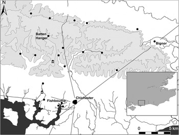
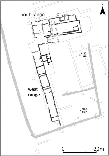
It is uncommon for the latest phases of Roman buildings in the rural landscape to survive relatively undisturbed. The reuse of stone, ploughing and inadequate excavation have often destroyed the latest phases or rendered them unintelligible. The villa at Batten Hanger, Elsted, in West Sussex (fig. 1; SU 818 153), was first noted in 1971 when a field between two wooded slopes in a dry valley draining south-eastwards on the Chalk to the river Lavant and onto the Quaternary deposits of the coastal plain, was ploughed, perhaps for the first time. A scatter of building debris, including tesserae and tile, clearly indicated substantial Roman buildings. The site (fig. 2) lies at 95 m OD, c. 11 km north-north-west of Chichester, Roman Noviomagus Reginorum, and it forms one of a group of villas lying in similar situations in dry valleys on the dipslope of the South Downs, north of Chichester (fig. 1).Footnote 1 By the late 1980s, it had become evident that cultivation was resulting in significant structural damage and one of us, the late John Magilton, then Director of the now disbanded Chichester District Archaeological Unit, decided that excavation at least of the latest levels was an essential prerequisite to a request for scheduling and, with the willing co-operation of the West Dean Estate, return of the site to grassland. Excavations were carried out between 1988 and 1991, and a final report is in preparation.Footnote 2 The latest phase of the villa, however, the construction of a large ‘hall’ at the end of the fourth century or into the fifth century, is of more than local significance and is considered in this paper.
Location map. Batten Hanger, other villas and major Roman sites in the Chichester region. (Drawing: J. Kenny; © Chichester District Council)

Plan of the Batten Hanger villa in its latest phases. The ‘hall’ can be seen on the same alignment as its predecessor, a large aisled building, but offset from its foundations. (Drawing: J. Kenny; © Chichester District Council)

The villa consisted of a north range, 40 m long, lying across the dry valley and facing south, and a west range, 65 m long, lying at a right angle to this, both fronting onto a common courtyard (fig. 2). The earlier phase of the north range was represented by fragmentary stone walls between later structures. The later phase consisted of a large aisled structure into which a small bath-house had been inserted on the north side; a further room with hypocaust lay in the south-east corner of the aisled building. The west range started as a small structure of four small rooms, possibly part-timbered, which was progressively replaced by a row of rooms 65 m long.
THE ‘HALL’
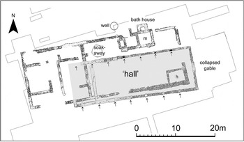
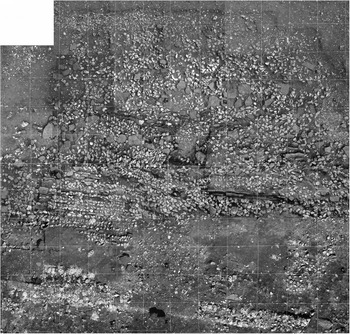
After the demolition of much of the aisled building, it was replaced by a structure on the same alignment, measuring 31.6 by 11.5 m externally, tapered slightly towards the west end (fig. 3). The survival of the greater part of the east, gable-end wall as it fell outwards (figs 4–5) allows a detailed reconstruction of the elevation of the building. The east wall had a central doorway, c. 2.6 m wide and 3 m high, with a central doorstop and presumably a wooden lintel over it. Approximately 2 m above the doorway, and central to it, was a further smaller opening, 1.2 m wide by 1.5 m high, again with a wooden lintel. The height to the top of the gable appears to have been c. 10 m, although the imbricate nature of the collapsed stonework, with its bonding courses of Greensand, Horsham Stone and tile, makes this a maximum figure. If the continuous levelling course of tiles reflects the height of the side walls, then these may be estimated at c. 4 m. All walls were primarily constructed of mortared coursed flint, with some Chalk rubble and Greensand sandstone, regularly laid on footings 0.65 m wide. The fallen east wall was divided by contrasting bonding courses of other stone or tile. The thin slabs of Horsham Stone have caused some distortion and collapse domino-fashion, and there is some indication of a slight torsional clockwise twist in the fall, with the south-east quoins lying at an angle to the footings. Most of the larger stones of the quoins had been removed, although their position is evident in the gaps in the surviving stonework. The east wall had a course of tiles, imbrices and tegulae, correctly laid as if in roofing, which spanned the entire wall, 0.75 m above the doorway. Within the gable two further string courses of Greensand are followed by one of Horsham slabs, interrupted by the central opening above the door. At least one further stringer of reused tile and Greensand occurs above the opening. The gable was edged with Horsham Stone slabs and had been constructed with a repeating pattern of three courses of flint and a single course of brick. The main part of the wall appears to have had a repeating pattern of four courses of flint and a single course of Greensand, repeated three times, followed by two courses of flint and a course of Horsham Stone; there are then at least four courses of flint before the tile course. The Greensand slabs act as a bonding course, which runs into the wall, and similar slabs were incorporated into the quoins. Where the stone has been removed subsequent to the collapse of the wall, it is evident that the outer surface was plastered, presumably with the string courses and perhaps the quoins showing through.
Plan of the ‘hall’ and underlying structures. The positions of the pad stones for the trusses are indicated by the arrows. The small bath-house to the north may have continued in use, perhaps with a differing function, adjacent to the ‘hall’. (Drawing: J. Kenny; © Chichester District Council)

Rectified photograph of the collapsed east wall of the ‘hall’. The superimposed grid is of 1 metre squares. (Photomosaic: J. Kenny and J.R. Magilton; © Chichester District Council)

The east wall, showing in colour code the various stone and tile types. (Drawing: R. Browse and J. Kenny; © Chichester District Council)

The pitch of the roof can be reconstructed from the surviving maximum width of the gable at various levels and from the minimum height of the side walls. It is assumed that the section of masonry to the north of the door, including the quoins, fell flat to the ground without significant distortion, and that any apparent spread resulted from subsequent erosion. This is because the tile, Greensand stone, and Horsham slab courses, and the elements of the quoins, were still almost completely perpendicular to the ground when excavated. This gives a maximum height for the quoins of between 3 m and 4 m. The tile course would have finished just above the highest remaining part of the quoins, having a total width of c. 9.1 m, and the Greensand stone course above it would have had a total width of c. 7.8 m. The maximum width of the upper Horsham slab course would have been c. 6 m at its lowest maximum height of c. 5.8 m above ground level.
The height of the side wall and maximum width of the tile course give a pitch of c. 45 degrees and an apex height of c. 10 m, provided the gable was not hipped. The maximum width of the tile course, the Greensand stone course and the Horsham slab course give a minimum pitch of between c. 40 and 48 degrees and a minimum height of between c. 8 m and 9.2 m, with a side wall height of slightly over 3 m. These pitches would all exclude the use of tegulae and imbrices, which are thought to require pitches nearer 30 degrees,Footnote 3 but the lower range would suit pegged stone tiles and the upper range wood shingles or thatch, where the optimum pitch for a thatched roof is between 45 and 60 degrees.Footnote 4 On historic buildings the length of the rafter is often three-quarters that of the span. The 48 degrees pitch, with a rafter length of 8.6 m, on a span of 11.5 m, would fit this pattern exactly.
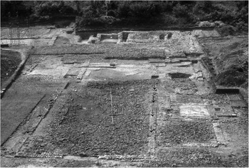
With an internal width in excess of 10 m, this is a difficult space to span and the wall thickness is slight to take the weight and outward thrust of any substantial roof. Incorporated in the base of the side walls, however, are blocks of sandstone of irregular shape, more or less opposed, clearly intended as pad stones to take the base of large timbers (figs 3 and 6). These indicate that the building had been of seven bays each c. 4.2 m long. At the west end a short bay, only 1.5 m long, separates the final truss from the end wall, while at the east end, the final bay appears slightly longer. There is no surviving evidence that either roof timbers or any wall plate were keyed into the end wall and the weight of any roof would have been taken on the trusses rather than the walls. Fortuitously, the failure to key the end wall effectively into the structure led to its coherent collapse and preservation. It is unfortunate that the site had already suffered some stone removal and recent plough damage before excavation, and only a single sandstone pad which may have functioned as an aisle post remained in situ. If this is accepted as not being part of the previous building, the aisles would have been c. 2.4 m wide, half the width of the nave. On balance, however, the absence of any differentiation in the east wall between any putative aisles and nave and the paucity of evidence for internal supports would suggest a single open hall. No floors or hearths survived and presumably an earth floor had existed over the rubble from the earlier aisled building. Bioturbation, largely worm action, will have incorporated this into the shallow soil profile. The only internal sub-division was found at the western end, where a partition had divided the end bay from the rest of the building to form a room measuring c. 10 by 5 m internally. Conventionally, this would be regarded as the residential portion of a largely agricultural building and this may well have been the case. In plan, the provision looks ungenerous but the accommodation could have been on at least two floors, given the building's height. No clear indication of supports for the end of joists for an upper floor was evident in the collapsed east wall, although any such structure would probably have been supported on the roof trusses, thereby improving their stability. It is therefore uncertain whether the opening in the east wall served to light an upper floor or an open hall.
The ‘hall’ under excavation, viewed from the west with the pad stones for the base of the trusses arrowed. (Photograph: J.R. Magilton; © Chichester District Council)

North of the building, the bath-house, once incorporated in the earlier aisled building, almost certainly still remained in existence but now as a free-standing structure, and it is probable that its location influenced the ground-plan of the new building since two of the bays are on the line of its end walls. It is apparent, however, that much, if not all of the earlier aisled building had been reduced to its foundation level before the ‘hall’ was built and while the latter maintains its alignment, presumably dictated by the extant bath-house, the new structure was built across the earlier south and east walls, perhaps implying that there was a significant gap between demolition and new construction. West of the bath-house, sealing its drain, was a rectangular floor of Chalk rubble, presumably of a lean-to structure built in the angle between the baths and the north wall of the aisled building. The north wall of this structure could have utilised a remaining part of the north wall of the earlier aisled building; no certain trace of a west wall could be found.
THE SUPERSTRUCTURE
With the survival, virtually complete, of the east wall with its decorative strips and bonding courses, there can be little doubt that externally the excavated structure was intended to be seen as a stone, rather than part-timbered building. The absence of any provision for securing the ends of timberwork in the surviving east wall, other than lintels for doorway and window, suggests that the building was not of box-frame construction and that the roof was supported on large timbers independent of the walls. Indeed, the survival of the entire east wall of the building probably reflects the position of the adjacent roof truss and the failure to tie the wall into the rest of the structure, leaving it vulnerable to gales coming from the west. Where the size of the pad stone is evident, the maximum size of the super-incumbent timber appears to be c. 0.75 m by 0.5 m. These did not extend to the outer face of the wall, being concealed by a thin layer of stonework. It seems unlikely that paired uprights supported wall plates and 11 m-long horizontal tie-beams across the space, while the slight offset evident in some pairs also militates against this interpretation. If, however, paired curved timbers, meeting a central ridge were employed, then the offset would either not be a problem or even necessary if the uprights were dowelled together rather than jointed at the apex. Variation in the height of individual trusses could be accommodated by short lengths of ridge rather than a unitary ridge timber, albeit made up of sections. This is essentially a form of construction known as cruck,Footnote 5 best illustrated by medieval and later buildings, which range in size from small peasant cottages to over 10 m-wide monastic tithe barns like that at Leigh Court in Worcestershire.Footnote 6 Some idea of the scale of the Batten Hanger building is obtained by comparison with the latter, which is 11 m wide by 36 m long and of 11 bays.
DATING
The date range of the latest major modification of the preceding aisled building is provided by a coin (small nummus) incorporated into a wall of the hypocaust built into the south-east corner. This had been minted in a.d. 335 or later. Coin evidence provides a similar terminus post quem for the construction of the bath-house to the north, which probably continued in use after the demolition of the aisled building. Forty-one small bronze coins were recovered from the area of the latest building and these range in date from a single radiate of Claudius Gothicus (a.d. 268–70), which may be an earlier casual loss, to a close group of small bronzes (nummi) of the end of the fourth century, with SALVS REIPVBLICAE and VICTORIA AVGGG issues of both Honorius and Arcadius.Footnote 7 Rather than evidence of monetary activity in the building, the group, closely scattered at the south-east corner, is interpreted as a small hoard which had been concealed within the building's walls or roof and been scattered as the structure decayed. GuestFootnote 8 has argued that hoards of similar composition, terminating with some of the latest official coinage to reach Roman Britain, belong, at the earliest, to the a.d. 420s. The presence of a nummus of Valentinian III minted a.d. 425–35 (RIC X, 2110) from the Batten Hanger villa, unfortunately unstratified, serves to support this hypothesis. Since CaseyFootnote 9 first noted a coin of this emperor from Wroxeter, a number of other examples have been published, including a gold solidus from Chichester,Footnote 10 although the provenance of the latter has been questioned.Footnote 11 Setting aside the occurrence of gold and silver coins modified as ornaments, many occurring in Anglo-Saxon graves, where pathways to eventual burial need not have been direct,Footnote 12 and hoards, where the coinage forms part of the hack silver and gold, such as that from Patching in West Sussex,Footnote 13 the number of early fifth-century coins remains small and there are few low denomination pieces. As well as the Wroxeter example, Abdy and WilliamsFootnote 14 list nummi of Valentinian III from Caerwent in Monmouthshire, Dunstable in Bedfordshire, near St Albans, Hertfordshire, and Richborough, Kent. While single finds may result from casual imports of coins as items with individual histories, like the fragments of Mediterranean marble from Irish Early Christian sites,Footnote 15 the Batten Hanger hoard is more suggestive of coin use and concealment with intent to recover. It further implies occupation of the site well into the fifth century in a building which appears to combine Roman with north European structural elements.
The pottery assemblages associated with the demolition of the aisled hall and occupation within its successor indicate what pottery was in use on site at the end of the fourth century and during the first half of the fifth century.Footnote 16 They make an important contribution to the ongoing debate as to when Romano-British style pottery ceased being made in southern Britain.Footnote 17 More than three quarters of the pottery supplied to the site during the early years of the fifth century came from the Alice Holt kilnsFootnote 18 and related OverweyFootnote 19 ones to the north of Batten Hanger, with much of the rest being fine wares from the Oxfordshire kilns.Footnote 20 A few pots in high-temperature-fired greyware, both handmade and wheel-turned with black ironstone and slag inclusions, were probably made at a more local source which was also involved in iron production. How long pottery supply continued is uncertain, but the small number of fragments from the rubble within the late building suggests that pottery had ceased being used by the time of its abandonment during the second quarter of the fifth century or later.
DISCUSSION
There are few buildings in Roman Britain where an entire elevation has been preserved. A similar use of strips and levelling and bonding courses is seen at the Meonstoke villa in east Hampshire, some 20 km to the north-west, although there the strips, constructed in tile, flank blind arcading with simple sandstone Ionic capitals on the frontage of an aisled building of basilican plan, with a central nave flanked by aisles.Footnote 21 While the evidence is not entirely incontrovertible, the Batten Hanger building appears better reconstructed under a single span, essentially an open hall, entered from the east through a broad doorway with wooden architraves over both doorway and rectangular opening above. While quoins and bonding courses do not directly flank either door or window, it is apparent that the decorative layout of stone and tile and the mortar facing would have reinforced the Roman character of the building. At Redlands Farm in Northamptonshire the villa again shows levelling courses of tile, although much of the intervening stonework is laid herringbone fashion; the collapsed walls clearly indicate a two-storey structure.Footnote 22 The Batten Hanger wall has similar overall dimensions to the fragment excavated at Carsington in Derbyshire, where the base was 9 m across, the height 11.5 m, and the pitch of the roof was 40 degrees. The Carsington building, however, was apparently dry-stone walledFootnote 23 and the lower pitch suggests a stone-tiled roof rather than thatch or shingle; in the limited area preserved at Carsington there was no evidence of decorative or structural features or any openings. This example has a much lower roof pitch than Batten Hanger which, at c. 45 degrees, appears steep. This would require more extensive purlins and rafters with large numbers of nails or pegs to hold any much heavier Horsham Stone slate roof. Examples of the latter, reused from earlier buildings on the site, were widespread amongst the debris on the surface of the field, and ceramic skeuomorphs of these distinctively shaped slabs were reused structurally in the bath-house.
While the character of the exterior of the Batten Hanger building was clearly intended to be Roman, the interior is more problematic and it is tempting to interpret this as an open hall with domestic accommodation screened off across the western end. Whether such a ‘hall’ should be seen as agricultural or domestic in the medieval sense of a hall is a further problem; in either case in the context of Roman Britain it is unusual, if not unique, although some of the yards reinterpreted by SmithFootnote 24 as halls may have been similar.
Following on from Smith's initial hypothesisFootnote 25 that cruck construction had its origins in the ‘Celtic West’, BraniganFootnote 26 was the first to suggest a cruck building in a late Roman or early post-Roman context, at the villa site at Latimer in Buckinghamshire. AddymanFootnote 27 was very disparaging of the claim and suggested that the structure, a mere 1.75 m wide and 14.75 m long, was more likely ‘an internally braced heavy platform, perhaps used in connection with harvesting’. Such structures, however, in which the weight of a stone slabbed and turfed roof was taken on internal posts, often reused from older buildings or driftwood, and the walls were essentially free-standing of drystone and turf, were widespread until recently in the North Atlantic region and were used for stalling animals.Footnote 28 Whatever its ethnic affiliation, the Latimer building is best seen as a low animal house — the shape of the post-holes not necessarily reflecting cruck construction but the reuse of timbers. GreenFootnote 29 similarly has claimed cruck-framed buildings from excavated evidence of fourth-century buildings in the Roman town at Godmanchester, near Huntingdon, although the evidence is no more conclusive. PerringFootnote 30 in his book on buildings in Roman Britain suggests that cruck construction ‘was not a mainstream building type among the Romanised communities of Britain’. The most recent discussion of a potential cruck building in the late or immediately post-Roman period comes from the other end of the province, from Wilmott's consideration of the structure built over the demolished granary at Birdoswald on Hadrian's Wall.Footnote 31 He is more circumspect, drawing parallels from post-Roman halls in the frontier zone, although none is definitively of cruck construction. More recently, GardinerFootnote 32 has preferred to interpret this building as a timber-framed, rather than a cruck structure. As Barker's excavation and interpretation of the tenuous traces of substantial buildings over the baths basilica at Wroxeter indicate,Footnote 33 surface-built timber-framed structures often leave little evidence, while CharlesFootnote 34 has made a similar point with regard to cruck-framed buildings. The weight of the individual timber blades, raised in pairs, would make earth-fast ends impractical for all but the smallest structures, such as the ‘peasant’ houses noted by Wrathmell.Footnote 35 Archaeological evidence is, therefore, likely to be sparse and most Roman villa excavations have been on an insufficient scale or insufficiently precise to define such buildings, particularly where they were the latest on the site and often much disturbed. The prevailing paradigm, however, is that cruck construction is of medieval origin.Footnote 36 As WilmottFootnote 37 observes, it is frequently virtually impossible to indicate the superstructure of surface-built buildings; however, sufficient remains of the Batten Hanger ‘hall’ to be fairly confident of its reconstruction as cruck-built.
The nature of cruck construction has implications for landscape management outside the simple acquisition of suitable timber. Ian TyersFootnote 38 has suggested that crucks reflect the sourcing of large timbers from hedgerow trees rather than from managed compartments of coppice with standards, where straighter if younger trees would have been available. A landscape dominated by wood pasture, with open grown older trees, would provide similar trees for cruck blades. It is unfortunate that neither dendroecology nor palaeoecology can so far resolve this hypothesis.
It is important to recognise the scale of the ‘hall’ at Batten Hanger. While it is smaller than the aisled building which preceded it (fig. 2), with seven bays, an internal width in excess of 10 m, a length of 31 m and near 10 m to the apex of the gable, this is no declining late Roman occupation of the villa site, although the artefactual record, excepting the one fifth-century coin, contains nothing which would pick the site out as something unusual. Interpreted in the same way as its medieval surviving parallels, like Leigh in Worcestershire,Footnote 39 the structure could be seen as a barn, functioning as a major redistributive centre, although in the context of late Roman Sussex the question is where to, in that what is known of contemporary Chichester reveals relatively little late occupation. If this line of argument is to be followed, inevitably the connection has to be seen to be with the military supply system. Some support for such a line of argument might be gleaned from the animal bone evidence, largely the assemblage from the adjacent bath-house soakaway, which must have been utilised as a rubbish pit after the bathing facility ceased to function.Footnote 40 A coin of Valentinian II (a.d. 378–83) from the upper filling indicates a late fourth-century or later date. In terms of villa bone assemblages, the group is unusual in the number of old cattle represented, which may reflect the processing of animals for their skins and ultimately leather. Similar assemblages are not infrequent in the latest levels of forts in the NorthFootnote 41 while the largest user of such materials is similarly likely to have been some sort of military unit. Garrisons at PevenseyFootnote 42 and PortchesterFootnote 43 would need to be provisioned and their terminal dates remain uncertain, although the Anglo-Saxon Chronicle entry for the fall of the former to an invading group in a.d. 491 (471)Footnote 44 has to be significant. The virtual absence of early Saxon burials in the western part of West Sussex, noted by Welch,Footnote 45 could imply a late surviving indigenous élite centred on Chichester and the coastal plain into the fifth century. Batten Hanger and the single piece of late Roman military metalwork, an amphora-shaped strap end from the adjacent villa at Chilgrove 2,Footnote 46 may hint at how this was maintained and a model not too dissimilar from that proposed by CollinsFootnote 47 for the northern frontier should be considered, with a post-Empire break-up into small units, variously referred to as chiefdoms or kingdoms,Footnote 48 based either on military or civil local élite. To advance a tentative scenario, it is possible that the Batten Hanger ‘hall’ reflects measures put in place, perhaps settlement of foederati, when the field army and other units were taken across the Channel for some ultimately unsuccessful bid for the Empire. If this were to be the case, then that of Constantine III in a.d. 407 would fit the Batten Hanger evidence. Too much, however, should not be made of single finds, and this hypothesis remains as such, only a hypothesis.
If the replacement of an aisled building, combining domestic and agricultural functions, by an open hall in the late or immediately post-Roman period is accepted, then some comment on the social, and perhaps ethnic context is in order. Smith,Footnote 49 developing a seminal paper by Stevens,Footnote 50 comments on the problems of applying Roman law in a Celtic context and effectively reinterprets villa plans in terms of multiple, if familial ownership. Although Smith's model has been criticised,Footnote 51 the evidence in plan for some sort of multiple occupancy remains, and the earlier villa at Batten Hanger fits well with this concept, with the west range being discrete yet connected to the aisled building and bath-house by a wall in the north-west corner. Its replacement perhaps sometime in the fifth century by a ‘hall’ implies a different social structure, perhaps a replacement of some variant of partible inheritance by a patri- or matrilinear one. As SmithFootnote 52 also notes, villas incorporating halls also occur in Germania, where the aisleless rectangular form extends back at least to the early Roman period. Some, as those at Brücken, in Rheinland-Pfalz, and Heppenheim, Hessen,Footnote 53 are similar to the Batten Hanger hall in width and a similarly sized ‘hall’ forms part of the villa at Maillen-Al Sauvenière in Belgium.Footnote 54 The excavations, however, are too old to ascertain whether post-bases or post-holes were simply missed, while the same applies to possible English examples, such as Byfield in Northamptonshire.Footnote 55 Although both Wijster and Odoorn in the Netherlands are often quoted as early cruck buildings,Footnote 56 the Low Country and north German evidence for Roman Iron Age cruck buildings still remains, as AddymanFootnote 57 noted in 1981, tenuous. The question remains as to whether the hall is the imposition of a new social order by a new owner, and if so, when, and where did the new occupants come from? Any new estate owner, or tenant, need not be a ‘German’ immigrant from within or outside the Empire. What seems to be apparent from the structural remains at Batten Hanger, however, is a concern to maintain a certain Romanitas about the new building, even if inside a new social order was in evidence.
SUPPLEMENTARY MATERIAL: CONTENTS
For supplementary material for this article please visit http://journals.cambridge.org/bri
Note: the Supplementary Material includes online fig. 1 and Tables 1–4.
SECTION 1: The Coin hoard By Malcolm Lyne D1–5
SECTION 2: The Pottery By Malcolm Lyne D5–17
Bibliography D17–18
ACKNOWLEDGEMENTS
The authors are grateful to Eleanor Magilton for facilitating this research after John's untimely death and to Ian Tyers for his encylopaedic knowledge of medieval timber buildings. Patrick Hunter kindly made available his report on the animal bones in advance of the final publication.