Introduction
New Zealand’s Latitudinal Gradient Project (LGP) is based on a central hypothesis that ice-driven dynamics control the structure and function of marine, terrestrial and freshwater ecosystems along the latitudinal transect down the length of Victoria Land. The dynamics of ice encompasses a range of processes that include the extent and duration of snow, glaciers, sea ice and other ice covers. By utilizing a latitudinal transect, along which changes in the dynamics of ice and the balance points in ice-water transitions can be expected to gradually change, the LGP seeks to provide insight into how ecosystems are structured by comparing them along environmental gradients. The LGP concept also contains an underlying assumption that climate is related to latitude and, in a warming world (Steig et al. Reference Steig, Schneider, Rutherford, Mann, Comiso and Shindell2009), that latitude can also be used as a predictive surrogate for time.
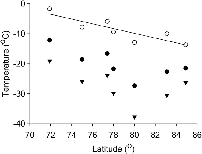
Terrestrial studies in the LGP have so far spanned a range of 14 degrees of latitude along the western side of Victoria Land from Cape Adare at (72°S) to the La Gorce Mountains at (86°S) (Howard-Williams et al. Reference Howard-Williams, Peterson, Lyons, Cattaneo-Vietti and Gordon2006), a gradient along which mean annual temperature varies considerably (Fig. 1). Marine studies extend from 78°S in McMurdo Sound to ship-based studies as far north as 66°S, from areas where sea ice is present year round to those where Southern Ocean conditions apply. In addition, in this issue complementary studies from other sectors of Antarctica provide information across similar or greater latitudinal ranges. There can be no doubt that, simply by providing access to previously data-poor locations, the LGP has broadened our understanding of ecosystems across Victoria Land. But has it improved our overall understanding of the importance of climate and the physical environment on Antarctic ecosystems? To what extent are the initial questions and hypotheses posed by the LGP community being borne out in practice? Is ice-driven dynamics the overarching variable that we thought it was? Is latitude in any way a useful surrogate for climate - and if not, does it matter if we have gained insights into specific questions that can best, or even only, be addressed by inter-site comparisons?
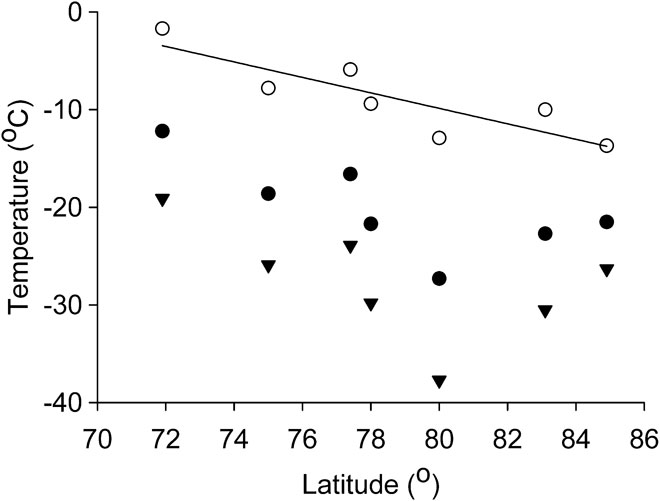
Mean annual (closed circles), summer (November–February - open circles) and winter (May–August - triangles) temperatures for the calendar year 2000 at seven automated weather stations that span the Ross Sea sector LGP sites. The line is a significant (P = 0.012) linear regression of latitude vs summer temperature. Data sourced from http://amrc.ssec.wisc.edu/aws.html.
Experimental design
With all comparative experiments, validity is dependent on the extent to which it can be reasonably assumed that, except for the variables within the comparison - in this case latitude and its correlates - systems would be essentially similar. Where this assumption is not reasonable or is in some way confounded, it must be controlled by using either a multidimensional comparison or by selection of samples in a manner that gives the maximum opportunity for that assumption to be true. It was realized early in the project that at any one latitude there is considerable variability in the environment induced by altitude, aspect, local geology and geomorphology (Howard-Williams et al. Reference Howard-Williams, Peterson, Lyons, Cattaneo-Vietti and Gordon2006). In addition, the biota present in a given area can vary due to legacy effects resulting from advance and retreat from the last Glacial Maximum (c. 10 000 yr bp) and previous glacial events, the patchy availability of refugia and the slow post-glacial recolonization (Howard-Williams et al. Reference Howard-Williams, Peterson, Lyons, Cattaneo-Vietti and Gordon2006, Adams et al. Reference Adams, Bardgett, Ayres, Wall, Aislabie, Bamforth, Bargagli, Cary, Cavacini, Connell, Convey, Fell, Frati, Hogg, Newsham, O’Donnell, Russell, Seppelt and Stevens2006). We will see that these themes are well represented in the latest research, with again the issues of local variability and legacy confounding latitudinal differences (e.g. Caruso et al. Reference Caruso, Hogg and Bargagli2010, Ruprecht et al. Reference Ruprecht, Lumbsch, Brunauer, Green and Turk2010).
The common observation that variability within any one LGP site could equal or exceed variability between sites was perhaps the most important issue identified in the LGP first Special Issue (Howard-Williams et al. Reference Howard-Williams, Peterson, Lyons, Cattaneo-Vietti and Gordon2006). It became clear that an analysis of scales of variability in ecosystem properties that allows for partitioning of the total variance within and between locations at a single latitude and between latitudes was a desirable approach (see Cummings et al. Reference Cummings, Thrush, Norkko, Andrew, Hewitt, Funnell and Schwarz2006). In this context the need to incorporate temporal variability, over seasonal, annual and decadal scales, for an understanding of long-lived ecosystems is also important (e.g. Barrett et al. Reference Barrett, Virginia, Wall, Doran, Fountain, Welch and Lyons2008). Several ways to take into account local and temporal variability at any given latitude were discussed by Howard-Williams et al. (Reference Howard-Williams, Peterson, Lyons, Cattaneo-Vietti and Gordon2006), including:
1. A crossed latitude vs altitude approach: which would require a comprehensive study of systems along altitudinal transects at each latitude.
2. Partitioning of local vs latitudinal variability: which would require an approach designed to quantify variation in space and time at a series of locations across the latitudinal transect.
As is often the case, the best approaches can be expensive. Broad-scale, synoptic sampling over many years at many locations may be a robust approach, but the logistic demands that it imposes are significant. In this issue Caruso et al. specifically consider the type of nested, hierarchical study designs that can best provide the kind of information on how environmental variables control ecosystem responses. As the LGP approach matures we are becoming better able to focus attention on its strengths and perhaps to refine the types of question being asked and studies undertaken to those that are amenable, informative and affordable.
This second LGP Special Issue allows us to evaluate the premises that the LGP was built on, to recap the successes and failures of the LGP approach to research in Antarctica over the last seven years, and to recommend future research models in an environment where field-based research is expensive and logistic and environmental considerations drive much of the research activity.
The LGP structure
Under the general hypothesis, the LGP is structured by a number of Key Questions. These have been modified as the LGP has evolved over time through a series of planning meetings, often associated with local and international meetings, to the current internationally agreed set. We asked authors of the papers making up this issue to indicate which key questions, as listed below, that their work relates to and these are indicated in Appendix I.
Key Questions:
1. How does ecosystem structure and function change with latitude, and why?
2. What is the role of persistent, large-scale ice structures in defining community composition?
3. How do snow and ice dynamics influence ecosystems and ecosystem processes?
4. How does climate affect the availability and composition of free water?
5. How does climate affect the predictability, persistence and extent of sea ice cover?
6. How are key marine biological processes influenced by sea ice conditions?
7. How does soil development influence terrestrial ecosystems?
8. To what extent are past conditions preserved in palaeo-indicators?
As the LGP has progressed, the number of sites that have been occupied has increased. This allows for a broader geographic coverage now than was possible in 2006 when the first synthesis issue was produced. Longer datasets from logging stations deployed at the various sites are now available to better address the issue of temporal variability, although the timescale of a few years is still rather short in comparison with the timescales over which climate varies and ecosystem processes are likely to be acting in Antarctica. Significant developments in recent years that relate to the LGP include the general acceptance of slow but measurable climatic change in Antarctica in IPCC reports and other publications (e.g. Steig et al. Reference Steig, Schneider, Rutherford, Mann, Comiso and Shindell2009), the suggestion that the Southern Annular Mode (SAM) climatic variation that has kept the Ross Sea Sector cooler by ∼1°C may be less effective in the future (e.g. Arblaster & Meehl Reference Arblaster and Meehl2006), and the various IPY initiatives which have focused attention on Antarctic environments. All of these developments provide background to this second Special Issue, which we anticipate will move forwards the analysis of the nature and causes of variability in Antarctica.
Summary of findings from the first Special Issue on LGP research
The first LGP Special Issue, summarized by Howard-Williams et al. (Reference Howard-Williams, Peterson, Lyons, Cattaneo-Vietti and Gordon2006) contained eighteen papers, one of which was a synthesis. Studies were geographically centred in the northern half of the Victoria Land gradient, from McMurdo Sound and the McMurdo Dry Valleys (78°S) (which we will hereafter refer to collectively as the McMurdo Sound region) up to Cape Hallett (72.30°S) and, via ship-based research, the Balleney Islands (66°S) (Table I). Within that geographic range, fifteen of the papers reported on terrestrial and coastal marine ecosystems from Cape Hallet and north, eight papers reported from Terra Nova Bay (74.30°S), and thirteen from the McMurdo Sound region. By topic, five studies reported on climate, soils and geochemistry, two on sea ice, four on terrestrial biodiversity, and five on marine ecosystems (which included sea ice).
Numbers of papers at different latitudes and across different ecosystems and environments that were included in the first LGP Special Issue. While the issue contained only 17 primary research papers, several covered more than one topic or latitude band.

Strict inter-site comparisons, involving datasets obtained using similar approaches at more than one site were made by only three of the 16 studies in the first Special Issue. Eight of the papers, however, provided information on sites over a latitudinal range, while the other eight papers provided baseline information at single latitudinal areas against which future comparisons were anticipated. In some cases those comparisons are being made in this issue (e.g. Webster-Brown et al. Reference Webster-Brown, Gall, Gibson, Wood and Hawes2010).
Thirteen of the first issue papers highlighted the importance of local variability on species and environment, while only three of the papers provided information that indicated that latitude was the predominant scale of variability. Few studies were specifically designed to quantitatively partition variability between structurally similar sites at a range of latitudes. An exception was that of Cummings et al. (Reference Cummings, Thrush, Norkko, Andrew, Hewitt, Funnell and Schwarz2006), which found that 66% of the variability in benthic marine community composition was due to local habitat structure.
On land, the principal environmental factors that were relatable to observed variability were:
• distance from the ocean (Witherow et al. Reference Witherow, Lyons, Bertler, Welch, Mayewski, Sneed, Nylen, Handley and Fountain2006, Bertler et al. Reference Bertler, Naish, Oerter, Kipfstuhl, Barrett, Mayewski and Kreutz2006, Wait et al. Reference Wait, Webster-Brown, Brown, Healy and Hawes2006, Healy et al. Reference Healy, Webster-Brown, Brown and Lane2006)
• altitude (Bertler et al. Reference Bertler, Naish, Oerter, Kipfstuhl, Barrett, Mayewski and Kreutz2006),
• presence of wind-blown dust (Witherow et al. Reference Witherow, Lyons, Bertler, Welch, Mayewski, Sneed, Nylen, Handley and Fountain2006),
• soil differences at local scales due to legacy effects or proximity to rookeries (Hofstee et al. Reference Hofstee, Balks, Petchey and Campbell2006a, Barrett et al. Reference Barrett, Virginia, Wall, Cary, Adams, Hacker and Aislabie2006, Brabyn et al. Reference Brabyn, Beard, Seppelt, Rudolph, Türk and Green2006),
• local variations in water availability (Hofstee et al. Reference Hofstee, Campbell, Balks and Aislabie2006b, Brabyn et al. Reference Brabyn, Beard, Seppelt, Rudolph, Türk and Green2006, Cannone et al. Reference Cannone2006, Novis & Smissen Reference Novis and Smissen2006).
The principal local sources of variability in coastal marine habitats were:
• local hydrodynamic conditions (Ryan et al. Reference Ryan, Hegseth, Martin, Davy, O’Toole, Ralph, McMinn and Thorn2006, Sewell Reference Sewell2006, Povero et al. Reference Povero, Castellano, Ruggieri, Monticelli, Saggiomo, Chiantore, Guidetti and Cattaneo-Vietti2006),
• local geomorphic or habitat conditions (De Domenico et al. Reference De Domenico, Chiantore, Buongiovanni, Paola, Ferranti, Ghione, Thrush, Cummings, Hewitt, Kroeger and Cattaneo-Vietti2006, Cummings et al. Reference Cummings, Thrush, Norkko, Andrew, Hewitt, Funnell and Schwarz2006),
• local sea ice thickness (Ryan et al. Reference Ryan, Hegseth, Martin, Davy, O’Toole, Ralph, McMinn and Thorn2006),
• iceberg disturbance on the sea bed (Schiaparelli et al. Reference Schiaparelli, Lörz and Cattaneo-Vietti2006, De Domenico et al. Reference De Domenico, Chiantore, Buongiovanni, Paola, Ferranti, Ghione, Thrush, Cummings, Hewitt, Kroeger and Cattaneo-Vietti2006, Thrush et al. Reference Thrush, Dayton, Cattaneo-Vietti, Chiantore, Cummings, Andrew, Hawes, Kim, Kvitek and Schwarz2006).
Where difference between latitudes was shown to be important, the variables associated with this were:
• the presence of soil aquifers at northern sites but not at southern ones (Hofstee et al. Reference Hofstee, Campbell, Balks and Aislabie2006b),
• a general decrease in coastal marine sediment organic matter northwards from Terra Nova Bay to Cape Adare (Povero et al. Reference Povero, Castellano, Ruggieri, Monticelli, Saggiomo, Chiantore, Guidetti and Cattaneo-Vietti2006),
• marked genetic differences between coastal marine mollusc populations at different sites (Guidetti et al. Reference Guidetti, Marcato, Chiantore, Patarnello, Albertelli and Cattaneo-Vietti2006).
Apart from warmer summer temperature and precipitation that allowed the formation of aquifers on more northern soils, the underlying drivers for the other latitudinal responses were not clear and difficult to ascribe to climatic effects.
Climate and latitude
While there is an underlying assumption of changing climate with latitude, until now no attempt has been made to determine the nature of this relationship. One reason for this is that the LGP comprises a series of independent studies and has not supported a mechanism for collection and collation of “overview” data. The latitudinal range of terrestrial sites within the Ross Sea Sector included in this issue stretches from 84°S to 70°S. Within that sweep there is no doubt that climate changes. Using data from a series of similar automated weather stations (AWS) in this sector operated by the University of Wisconsin, (http://amrc.ssec.wisc.edu/aws.html) and that were all operating throughout the calendar year 2000, we calculated annual mean, summer mean (November–February) and winter mean (May–August) temperatures for that year (Fig. 1). All are at < 110 m a.s.l. except the most southerly, which is at 660 m elevation. For the year 2000, the cooling tendency with increasing latitude was most evident for summer temperature, where a significant linear regression (r 2 = 0.69, P = 0.012, n = 7) could be obtained. While there also appeared to be an underlying cooling trend with increasing latitude for winter and for annual mean temperature, neither case gave a significant linear regression.
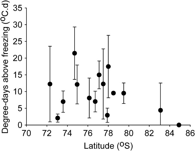
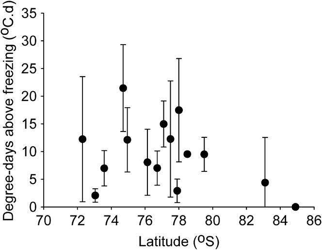
Figure 1 suggests that, at least for the year 2000, summer temperatures, which are the most likely to affect ice-water transition and the rate of biological processes, indeed show a convenient association to latitude such that a latitudinal transect can reasonably be expected to translate to an overarching climatic one. However, when we look more closely at climate variability within the Ross Sea sector, one of the reasons why latitude has so far proved a very weak ecological variable becomes clear. As an integrating measure of “probability of melt”, we calculated degree-days above freezing (DDAF) across a range of AWS sites within the LGP area (Fig. 2). The inter-annual variability in DDAF generally exceeds the differences between sites. Furthermore, variability between locations within a latitude band is such that no general north–south pattern in DDAF can be seen for the cluster of sites between 72 and 80°S. AWS sites are mostly close to sea level and when the effects of altitude and distance from the sea are allowed for (e.g. Welch et al. Reference Welch, Lyons, Whisner, Gardner, Gooseff, McKnight and Priscu2010) within-latitude variability is further enhanced. We might, however, hypothesize that a discontinuity may occur at the point where there are regularly no degree-days above freezing. Calculation of DDAF for the year 2000 at the sites in Figure 1 indicated that DDAF fell to zero close to latitude 80°S.
Degree days above freezing for sites where data are available within the Ross Sea Sector during the summers (November–February) within the decade 1998–2008. All measuring sites are established on rock. n varies between 3 and 10, the actual years for which data area available also vary and the type of data (hourly, 10 minute) varies. Nonetheless, this plot of mean ± 95% confidence of summer degree-days above freezing demonstrates the considerable within-site variability. Data sourced from http://amrc.ssec.wisc.edu/aws.html, http://www.lgp.aq/, authors unpublished.
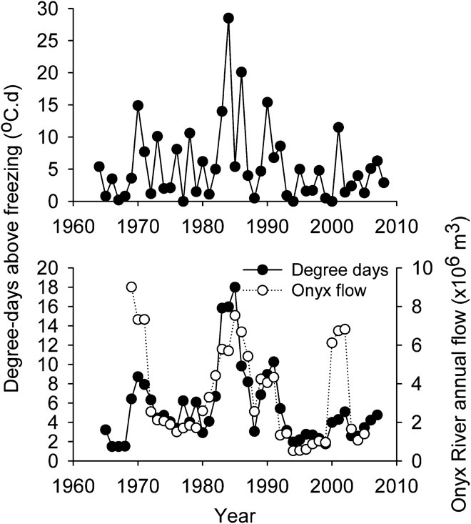
Long-term datasets give a better picture of within-site variation and are available for some locations, with those from the permanent national stations the best developed. Figure 3 shows how, over a period of four decades, DDAF at Scott Base vary from zero to 30 degree days. This site is located at 78°S, close to the current centre of the LGP transect, yet this range exceeds that for all sites in Fig. 2. Figure 3 also superimposes the Scott Base DDAF data on discharge of the Onyx River into Lake Vanda (also at 78°S), the only direct measure of water availability from this area for which a suitably long-term dataset is available. In this case we have smoothed the records by plotting a 3-year running mean, but the general correspondence (and decadal scale variability) of water availability and local melting conditions is compelling.
Top: Long-term record of summer degree-days above freezing for Scott Base, 78°S. Below: comparison of trends of degree-days above freezing at Scott Base and flow of the Onyx River into Lake Vanda. Three-year running means are used to smooth year-by-year variability in the lower figure. 2000 refers to the summer period November 2000–February 2001 etc. Data available from http://cliflo.niwa.co.nz//.

In summary, the general picture that has emerged from early analysis of information generated by the LGP within the Ross Sea Sector has shown how local and temporal variability confound any simple relationships between latitude, climate and ecosystems. Many other local variables have emerged as contributing rather more to structuring communities and habitats. Differences between climates at the various sites thus far examined have been insufficient to explore the ecosystem-climate questions posed by the programme. As the LGP continues and a greater range of comparable sites are accessed, including crossing “discontinuities” in variables such as DDAF, does this conclusion still apply?
Summary of findings from this second special issue
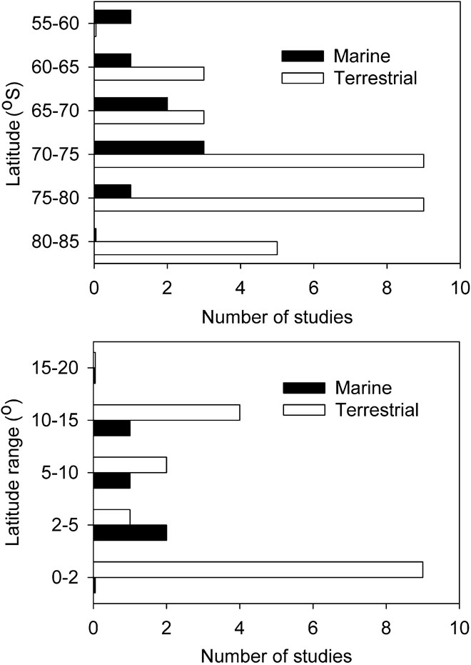
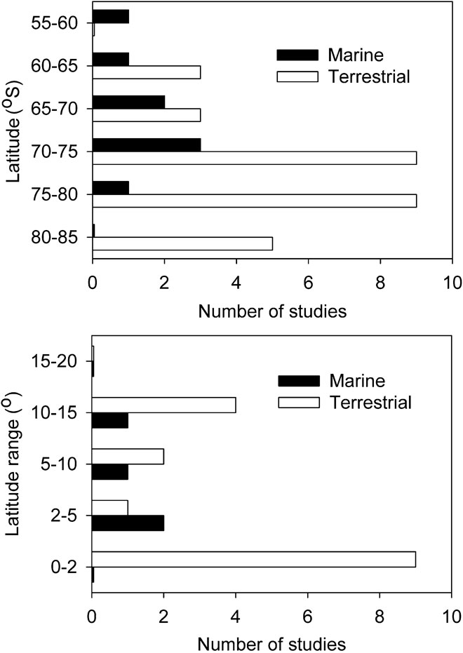
This second Special Issue covers mostly studies in the mid-sector of Victoria Land (Fig. 4). As in the first Special Issue, most have been terrestrial research, and the latitudinal foci relate to the distributions of LGP study sites and other sampling opportunities. Marine research has tended to cover broader latitude bands than terrestrial, the latter having been dominated by localized studies (Fig. 4). Logistics drives these patterns, with terrestrial studies mostly confined to proximity to stations or LGP sites between 70 and 80°S, while the broader spread of the marine studies reflects that they all included ship-based components.
Distribution of studies reported in this issue. Top: the bars represent the number of papers that report results from each 5° band of latitude. Some studies span more than one latitude band. Below: the bars represent the ranges of latitude reported on by individual studies. These figures summarize 20 studies; in the top figure studies may contribute to more than one bar.
Papers in this issue cover a greater latitudinal range than the first Special Edition, and one emergent observation is that studies covering very broad ranges, extending from continental through maritime and sub-Antarctic regions show clear patterns of change in biological communities. Morley et al. (Reference Morley, Griffiths, Barnes and Peck2010) compare the depth distribution of molluscs in the western Antarctic Peninsula and sub-Antarctic South Georgia. They show how differences in water temperature constrain the most stenothermal, low temperature-adapted bivalve species to cold, deep water at South Georgia while more eurythermal gastropods are not, and go on to suggest implications for species assemblages from potentially changing temperature regimes in Antarctic waters. Clark et al. (Reference Clark, Dunn, McMillan, Pinkerton, Stewart and Hanchet2010) also describe changes in faunal elements across a wide latitude range, in this case identifying three sub-regions from the southern Ross Sea through to sub-Antarctic seamounts. They too suggested that changes in temperature were important in affecting distributions, along with depth, current speed and seabed rugosity all of which changed to some extent from south to north. Interestingly, the next two marine papers in this issue operated over a smaller latitude range (71–75°S). Cummings et al. (Reference Cummings, Thrush, Chiantore, Hewitt and Cattaneo-Vietti2010) and Ghigliotti et al. (Reference Ghigliotti, Near, Ferrando, Vacchi and Pisano2010) found no clear north–south effects. However, Ghigliotti et al. (Reference Ghigliotti, Near, Ferrando, Vacchi and Pisano2010) found wide genetic diversification in this narrow latitudinal band in the northern Ross Sea. Papers in this issue support the view that changes in general conditions at sub-regional scales are sufficient to elicit biological responses, but that within sub-regions local conditions are the dominant source of variability. There are implications for management from such observations, concerning our understanding of the dimensions and environmental discriminators of sub-regions.
In the terrestrial environment, studies that compare information across regions show a similar response to latitude as those seen in marine habitats. When viewed over very large latitude ranges, there is a distinct north–south gradient in diversity, but when considered within a region or sub-region, latitudinal effects give way to local ones. Hills et al. (Reference Hills, Stevens and Gemmill2010) show that genetic diversity within bryophyte taxa, as well as the number of taxa, is much less across large areas of Victoria Land than in the sub-Antarctic, New Zealand or Australia. Similarly, Seppelt et al. (Reference Seppelt, Türk, Green, Moser, Pannewitz, Sancho and Schroeter2010), based on an extensive comparison of vegetation diversity, suggest that Victoria Land should be included as part of a continental Antarctic region that encompasses all of the continent except the Antarctic Peninsula, and within continental assemblages there is a similar degree of diversity regardless of latitude. The distinction between the Antarctic Peninsula and the continental Antarctic is reiterated by genetic studies of Torricelli et al. (Reference Torricelli, Frati, Convey, Telford and Carapelli2010), and physiological comparisons of Schroeter et al (Reference Schroeter, Green, Pannewitz, Schlensog and Sancho2010). Seppelt et al. (Reference Seppelt, Türk, Green, Moser, Pannewitz, Sancho and Schroeter2010) and Schroeter et al. (Reference Schroeter, Green, Pannewitz, Schlensog and Sancho2010) make compelling cases that, within continental Antarctica, it is local conditions, and particularly the availability of water and nutrients, that determine the vegetation response. Schroeter et al. (Reference Schroeter, Green, Pannewitz, Schlensog and Sancho2010) suggest that the temperatures at which plants become active in these two regions are rather similar, but the climatic differences mean that this translates to very different periods of activity each year. They also note that temperature alone is a simplistic view of climatic differences, but that the regions differ in irradiance and water availability, and make the interesting comment that the warm, wet regime may in some ways be more stressful than the cold dry regime insofar as the former requires plants to tolerate much longer periods of hydration during the dark, thus increasing the respiratory burden.
In a desert it is no surprise that water is a dominant ecosystem variable and not only Seppelt et al. (Reference Seppelt, Türk, Green, Moser, Pannewitz, Sancho and Schroeter2010) and Schroeter et al. (Reference Schroeter, Green, Pannewitz, Schlensog and Sancho2010) make this point. On local scales, Hawes et al. (Reference Hawes, Torricelli and Stevens2010) show that haplotype variability of springtails is greatest in the wettest areas, and on an even smaller spatial scale Cannone & Guglielmin (Reference Cannone and Guglielmin2010) argue for water availability as one of the micro-climatic variables that determine vegetation distributions within periglacial features (along with wind exposure and snow accumulation). Smith et al. (Reference Smith, Barrett, Tusnady, Rejto and Cary2010) show that wetness is one of suite of local variables that affect soil bacteria populations. Seybold et al. (Reference Seybold, Balks and Harms2010) show how soil wetness showed no north–south congruity over the latitudinal range of their observations (Minna Bluff to Granite Harbour) but that coastal sites were wetter than inland and high altitude sites and that proximity to snow runoff enhanced wetness. Their study makes clear how microclimate and topography can create different wetness regimes within a small latitudinal range. While climate is clearly implicated in soil wetness, and climate is related to latitude, local variability at scales from micro (as discussed by Cannone & Guglielmin Reference Cannone and Guglielmin2010) to those at a larger scale (i.e. distance inland from the coast - Seybold et al. Reference Seybold, Balks and Harms2010, Zawar-Reza et al. Reference Zawar-Reza, George, Storey and Lawson2010)) has to date prevented clear latitude effects from emerging.
Wetness regimes alone, however, do not completely explain observations in this issue. Overlain on and overlapping with meso- and micro-climate, legacy and cross-gradients effects emerge from the studies reported in this issue. Caruso et al, (Reference Caruso, Hogg and Bargagli2010), Hawes et al. (Reference Hawes, Torricelli and Stevens2010), Demetras et al. (Reference Demetras, Hogg, Banks and Adams2010), Torricelli et al. (Reference Torricelli, Frati, Convey, Telford and Carapelli2010) and Hills et al. (Reference Hills, Stevens and Gemmill2010) all suggest that the geographical distributions of ice-free refugia during previous glacial maxima, and the subsequent expansion of populations from those refugia, are over-printed on the current distributions of species and haplotypes. Storey et al. (Reference Storey, Fink, Hood, Joy, Shulmeister, Riger-Kusk and Stevens2010) use cosmogenic nuclide dating of erratics to show how the ice sheet has expanded and contracted over various time scales to create this mosaic of refugia. Evidence in this issue suggests that, like water availability, refugia can affect ecosystems at a range of spatial scales (which interact with the dispersal potential of the organisms involved), from broad north–south differences within Victoria Land to catchment-scale effects. Understanding the dynamics of past ice sheets has significant implications for interpretation of modern-day ecological patterns.
Cross-gradients are also found to be important elements of diversity in Victoria Land. Coast–inland transects, which involve elements of distance from sea and altitude, can impose environmental changes as large as, or larger than, latitude. Zawar-Reza et al. (Reference Zawar-Reza, George, Storey and Lawson2010) show how albedo, net radiation, wind (including the prevalence of katabatic/anabatic winds) and temperature vary over small scales and may affect ice and snow dynamics. Seybold et al. (Reference Seybold, Balks and Harms2010) show how aridity increases with distance from the coast and Welch et al. (Reference Welch, Lyons, Whisner, Gardner, Gooseff, McKnight and Priscu2010) provide comprehensive details of how environment changes with distance up the Taylor Valley and how this translates to significant clines in water chemistry. They relate differences in stream chemistry to landscape position, but also channel morphology, stream length and other biotic and abiotic processes. A consistent feature is the increase in the nitrate:chloride ratio with distance from the sea, due to the balance between marine aerosol and dry deposition of atmospheric nitrates and this is also noted by Webster-Brown et al. (Reference Webster-Brown, Gall, Gibson, Wood and Hawes2010). Webster-Brown et al. (Reference Webster-Brown, Gall, Gibson, Wood and Hawes2010) argue that this ratio, and other differences between aquatic habitats at sea level at 80°S and comparative ones at sea level at lower latitudes, may be as explicable in terms of distance from the sea as by any change in climate or latitude.
In addition to these general variables, specific requirements of some communities also play a role in determining their distribution. In this issue Cowan et al. (Reference Cowan, Khan, Pointing and Cary2010) show how complex hypolithic communities are significant biodiversity elements in Antarctic landscapes, yet their presence is dependent on quartz rocks of a suitable size. Similarly, Webster-Brown et al. note that the substratum on which meltwater pools form is more important than latitude in determining ecosystem characteristics. Smith et al. (Reference Smith, Barrett, Tusnady, Rejto and Cary2010) compare the genetic diversity of soil bacteria from Cape Hallett and the McMurdo Dry Valleys and note that it is related more to soil conditions than to latitude. Their samples from Cape Hallett were from soils more or less affected by birds, a soil type not found in the Dry Valleys, and again raises the complication that some habitat types, that may support discreet biota, are absent from some locations.
This second special issue on the Latitudinal Gradient Project supports previous observations that scales of ecosystem variability are such that latitudinal effects are visible only when viewed on large scales, that is across latitudinal ranges exceeding five degrees. Scales where latitudinal effects can be seen are continental, with evidence suggesting that most of Victoria Land so far examined can be grouped with all of the rest of the continent except the Antarctic Peninsula. Within regions a range of scales of variability contribute to observed diversity, including those related to the presence of refugia during previous glacial maxima and to distance from the sea. At meso- and micro- scales water availability dominates ecosystem structure, biomass and diversity. Whether these general observations extend to higher latitudes than those that have as yet been accessed by the field studies conducted to date remains to be tested. For the terrestrial system, the overwhelming significance of liquid water derived from snow or ice supports the LGP’s foundation hypothesis that dynamics of ice drives ecosystem function. This is less clear for marine ecosystems. While it may hold for local scales (i.e. discrete areas covering < 5 degrees of latitude - Cummings et al. Reference Cummings, Thrush, Norkko, Andrew, Hewitt, Funnell and Schwarz2006), at greater latitudinal ranges such as those reported in this issue, temperature has emerged as a key marine variable.
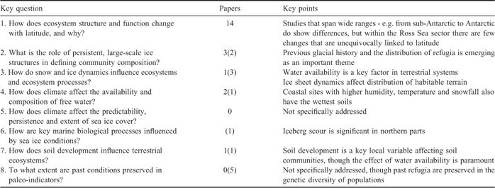
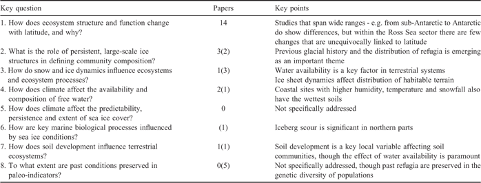
The quantum of work which this issue addresses to each key question varies (Table II, Appendix I) and there is a corresponding difference in our understanding. To an extent the key questions include a hierarchy of understanding, moving from primarily observation in Key Question 1 through to an increasingly mechanistic and potentially predictive understanding through to Key Question 7. We note that in practice many of the higher level questions, for example “How does climate affect the availability and composition of free water” are not necessarily best tackled by research at a range of locations. As the LGP progresses we hope that it attracts parallel studies that begin to address those higher levels of understanding.
The key questions of the LGP addressed in this special issue and key issues that have been raised by the various studies. Many papers address more than one key question. In column 2, the number of papers the first number refers to papers in which a key question is a research priority, the number in parentheses those for which a question was addressed less directly.
General discussion
Over the years ecological research has benefited from comparative and gradient approaches. Drawing together information from a range of systems has provided both scientific and managerial insights that would not necessarily have been so evident from single site studies. However, too often the “devil is in the detail” in such studies. It is easy to predict that a large change in a variable will result in a substantial response, but predicting the consequences of a small increase is much more uncertain. In the Antarctic context, scale is important (Appendix II) and moving from the sub-Antarctic islands, through the maritime Antarctic to the coastal continental and on to the interior surely provides any number of a readily identifiable gradients. It stretches from islands with warm summers with plentiful water, to “wet” Antarctica with abundant snow and some rain, through to higher latitude coastal desert areas and on to those where temperature never goes above freezing and liquid water is rare. Some papers in this edition touch on such gradients (Morley et al. Reference Morley, Griffiths, Barnes and Peck2010, Hills et al. Reference Hills, Stevens and Gemmill2010, Torricelli et al. Reference Torricelli, Frati, Convey, Telford and Carapelli2010, Schroeter et al. Reference Schroeter, Green, Pannewitz, Schlensog and Sancho2010) and show clear biodiversity and physiological implications from shifting away from the continental region. However, within the much shorter latitudinal transect encompassed by the Ross Sea Sector, some aspects of climate are predictable such as summer temperature trends with latitude (Fig. 1) but other aspects vary less predictably and consistently with latitude (e.g. Fig. 2). Many variables change sufficiently over small scales to make the subtle latitude/climate effects hard or impossible to detect. Further complexity is added when changing conditions with time are analysed (Fig. 3). The inability to recognize climate gradients over small spatial scales also raises doubts as to the resolution with which the effects of climate change on ecosystems can be predicted. Climate prediction is broad-scale in nature (Arblaster & Meehl Reference Arblaster and Meehl2006), changes in average temperatures are so far small and variable across Victoria Land (Steig et al. 2009) and small scale climate variability is well-known (Doran et al. Reference Doran, McKay, Clow, Dana, Fountain, Nylen and Lyons2002a). Findings in the LGP confirm that ecosystem changes in response to climate amelioration are likely to be mediated by shifts in water availability, but suggests that such effects are likely to be moderated by local conditions (see also Seppelt et al. Reference Seppelt, Türk, Green, Moser, Pannewitz, Sancho and Schroeter2010, Smith et al. Reference Smith, Barrett, Tusnady, Rejto and Cary2010).
Perhaps it is more useful to look on the LGP as a transect rather than a gradient, on which some variables change irregularly, some barely at all and a few in a more-or-less monotonic way. By examining systems along the latitudinal ‘transect’, the key hypothesis that “ice-driven dynamics control the structure and function of marine, terrestrial and freshwater ecosystems” has been examined and, as yet, not been falsified - certainly for the terrestrial and freshwater component - and this is consistent with findings from other large-scale Antarctic ecosystem research programmes (e.g. Doran et al. Reference Doran, Priscu, Lyons, Walsh, Fountain, McKnight, Moorhead, Virginia, Wall, Clow, Fritsen, McKay and Parsons2002b). In terrestrial systems, the availability of liquid water in an otherwise arid region has consistently proved to be the key variable. This is clearly related to the transition from ice and snow, though as yet attempts to specify what elements of climate determine that transition are lacking.
In marine systems, although there seems no doubt that sea ice dynamics and iceberg scour can be expected to relate to latitude and are ecologically important (e.g. Cummings et al. Reference Cummings, Thrush, Norkko, Andrew, Hewitt, Funnell and Schwarz2006), the patterns emerging here for wide latitudinal ranges (Morley et al. Reference Morley, Griffiths, Barnes and Peck2010, Clark et al. Reference Clark, Dunn, McMillan, Pinkerton, Stewart and Hanchet2010) include an emphasis on temperature and more traditional variables such as bottom characteristics, energy supply and depth. To a large extent the issue of the role of sea ice and its variability have not been addressed within the LGP context. Indeed, attempts to investigate the issues underpinning links between latitude, climate and ice-water dynamics (Key Questions 4 & 5) have, with the exception of Seybold et al. (Reference Seybold, Balks and Harms2010) and Zawar-Reza et al. (Reference Zawar-Reza, George, Storey and Lawson2010) been poorly addressed. To date the overwhelming attention of researchers has been Key Question 1 - how do things change over latitude?
As we discussed earlier, those habitats that are productive enough to possess a definable biota and are replicated across wide areas in ways that make them strictly comparable between sites can best be expected to show detectable change along gradients. Large, complex systems with a high degree of individuality, such as lakes or even pools, do not meet such a criterion, and neither do systems such as highly arid soils that support little biocomplexity. Two possible examples have emerged in this issue. Firstly Cowan et al. (Reference Cowan, Khan, Pointing and Cary2010) describe some remarkable hypolithic communities from the Miers Valley (78°S), made up of a diverse range of taxonomic entities and that seem to occur under small quartz rocks with a very high frequency. Clearly one might hypothesize that wherever suitable quartz occurs, then so should these hypoliths. This is clearly a small habitat type that can be expected to be repeated and replicated across wide landscapes. A second example is shown by the cryoconite holes described by Webster-Brown et al. (Reference Webster-Brown, Gall, Gibson, Wood and Hawes2010). Like the hypoliths, cryoconites are small and highly replicated ecosystem units that occur widely, wherever a glacier enters an ablation zone. Small units such as hypoliths and cryoconites facilitate the kind of stratified sampling approach that has been advocated in this issue (Caruso et al. Reference Caruso, Hogg and Bargagli2010) and previously by Howard-Williams et al. (Reference Howard-Williams, Peterson, Lyons, Cattaneo-Vietti and Gordon2006).
It has been recognized in many of the papers in this and the previous Special Issue that a latitudinal gradient encompasses several interacting ecosystem stressors that operate on a range of temporal and spatial scales. The challenge for future research is to approach the question of how Antarctic ecosystems are structured by and respond to environment from a ‘multiple stressor’ perspective. This involves recognition that two or more environmental stressors have an effect (environmental response) that may be additive, synergistic or antagonistic. Furthermore, different species assemblages may respond to multiple stressors in different ways due to co-tolerances or to competition between the species (Vinebrook et al. Reference Vinebrook, Cottingham, Norberg, Sheffer, Dodson, Maberley and Sommer2004). It is the combination of stressors and their collective effects on specific communities of organisms that is important. This is now recognized as a significant challenge for researchers in all fields of science (Mothershill et al. Reference Mothershill, Mosse and Seymour2007).
The LGP has shown that future ecosystem research in Antarctica will benefit from a recognition that:
• The non-linear responses in ecosystem properties to latitude that lead towards a “transect” description rather than a “gradient”.
• In order to quantify the effects of latitudinal changes, a wide latitudinal range must be covered and that research within ranges approaching, or less than, five degrees of latitude is not sufficient.
• The high variability in environment and biota shown at latitudinal bands of five degrees or less is due to factors such distance from the coast, topography and microclimate, altitude (or depth from the surface in marine environments).
• The concept of a multiple-scale patchwork of habitats and communities, more or less replicated across the transect, in which variability at any given latitude exceeds variability between latitudes (at least in a five degree latitudinal range) is apparent from these Special Issues.
• Systems that are easily identified and replicated across the landscape such as cryoconites, hypolithic (or endolithic?) communities are better able to be compared across wide latitudinal ranges than ecosystems that are formed in highly individualistic conditions such as lakes.
• An understanding of legacy effects from past climate change is critical in terrestrial and marine coastal Antarctic regions because of the over-riding importance of the last glacial maximum and previous glacial episodes in defining current ecosystem properties.
• There is a need for future research to incorporate the multiple stressor approach that will involve a joint consideration of the synergistic and antagonistic effects of several stressors acting in concert.
Acknowledgements
The LGP Scientific Steering Committee currently Drs Megan Balks (Chair), Clive Howard-Williams, Mark Stevens, Ian Hogg, Jenny Webster-Brown, Vonda Cummings, Ed Butler and Shulamit Gordon, together with former members of that team, has provided the science strategy that underpins the LGP activities and directions and their contribution is acknowledged. The LGP research is funded through the New Zealand Foundation for Research Science and Technology, the New Zealand Ministry of Fisheries, the Universities of Waikato, Wellington and Canterbury, the US National Science Foundation and the UK Natural Environment Research Council. Funding for the field logistics and transport has been through Antarctica New Zealand with an additional grant from the Ministry of Foreign Affairs and Trade. We thank The SCAR Biology Programme Evolution and Biodiversity in the Antarctic (EBA) and The New Zealand Trans-Antarctic Association for making the publication of this Special Issue possible. We acknowledge our international colleagues for the numerous insights and inspirations that they have given over the years, particularly the US McMurdo Dry Valleys Long Term Ecological Research programme, notably Professors Diana Wall, Dianne McKnight, Berry Lyons, John Priscu, Peter Doran and Andrew Fountain, who provide an example of long-term dedication to focussed research. We thank Cathy Seybold for assistance with retrieval of AWS data from University of Wisconsin archives and the anonymous reviewers.
Appendix I
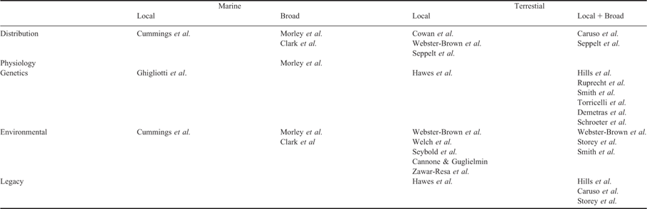
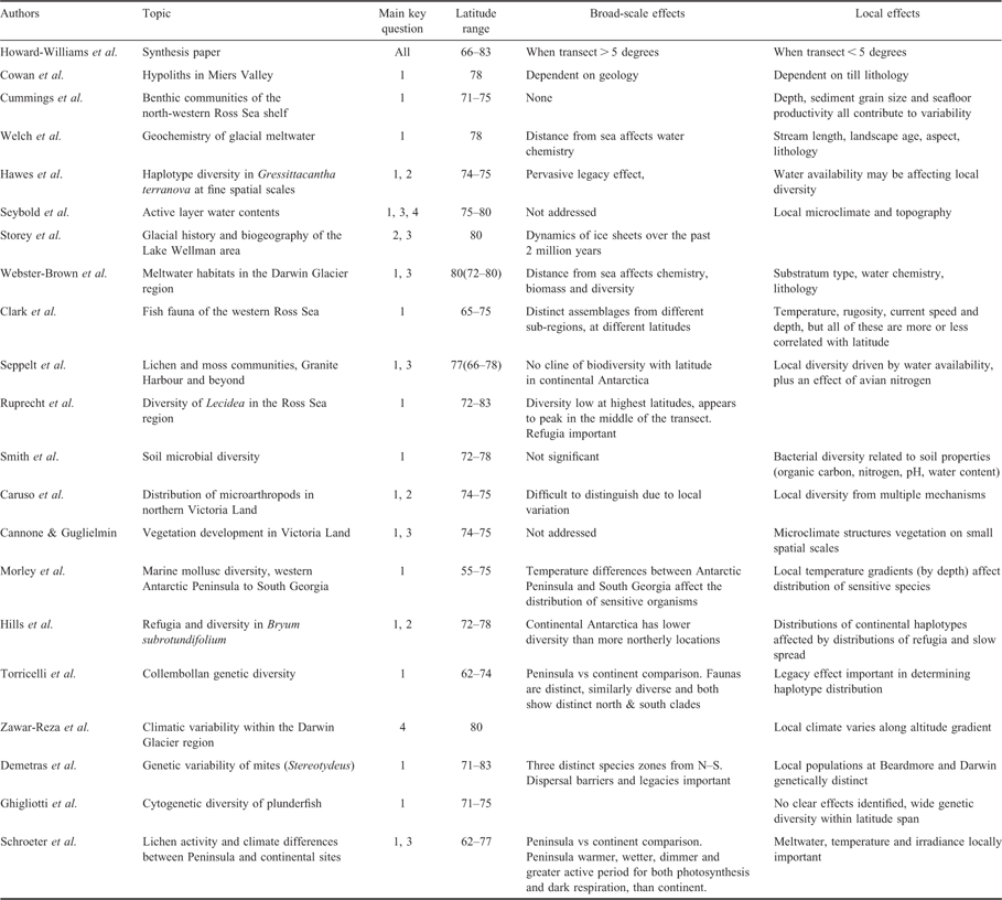
Summary of papers in this Special Issue on latitudinal gradient research. Indicated are the main LGP key questions that each paper addresses, the latitudinal range studied (range covered in discussion in parentheses) and what kind of broad and local scale effects were identified.
Appendix II
Scales of variability addressed by the various contributions to this issue. All references are to 2010.