[C]osmological narratives were instantiated not only in iconographic programs, but also in architectural form. This … suggests that structures often expressed fundamental cosmological concepts … [resulting in] a highly symbolic architecture (Carrasco Reference Carrasco, Werness-Rude and Spencer2015:402).
Michael Carrasco's observation that lowland Maya architecture embodied cosmology is attested by the structural complex known as an E Group. I suggest that the elongated eastern structures, the earliest manifestations of what eventually became known as E Groups, originated as replicas of the Milky Way, the celestial setting for the events recounted in Maya creation, origin, or etiological myths. I propose that these assemblages were dedicated to Maya cosmogony: beliefs about cosmogenesis and the events and protagonists of creation. We know these myths from imagery and texts of the Classic period and later, but early E Groups provide glimpses into the seeds of their underlying oral traditions and practices. I elaborate this proposition by briefly reviewing elements of Maya creation stories, current scientific knowledge about the Milky Way, and data on the eastern structures of early E Groups, closing with some possibilities for “testing” this proposition. My focus is on sites in the Department of El Peten, northern Guatemala, dating primarily to the late Early through Late Preclassic periods (c. 1400 B.C. to A.D. 200).
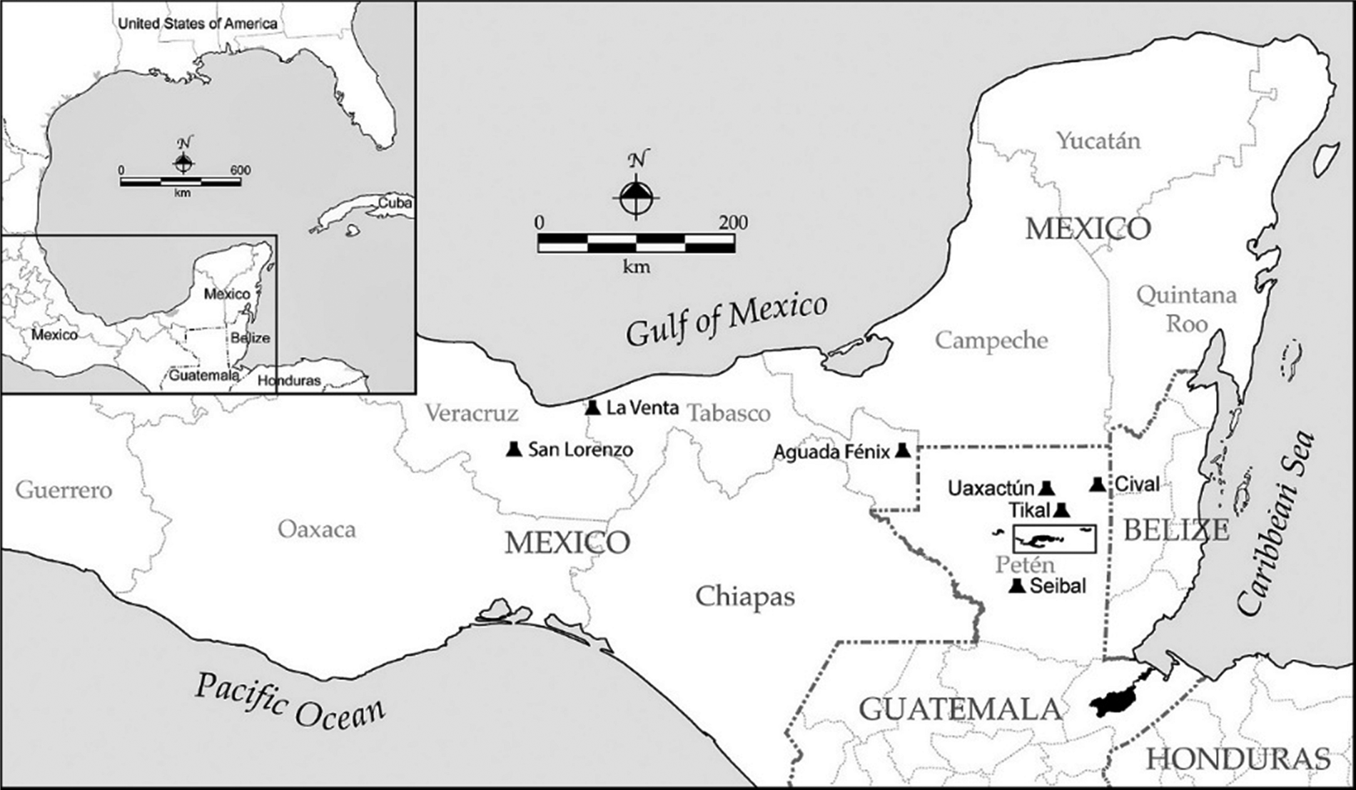
By way of background, the earliest well-known occupation of the southern Maya Lowlands (Figure 1) is that of the Middle Preclassic (or Formative) period, circa 900/800–400/300 B.C. Little material evidence of earlier (Early Preclassic/Formative and Archaic) prehorticultural, hunter/gatherer/fisher occupation has been recovered in Peten, but this does not mean that the area was devoid of humans. Pollen, charcoal, and various geochemical proxy indicators recovered in lake sediments have revealed forest clearing, maize grains, and other evidence of archaeologically invisible human settlement (e.g., Mueller et al. Reference Mueller, Islebe, Hillesheim, Grzesik, Anselmetti, Ariztegui, Brenner, Curtis, Hodell and Venz2009; Schupbach et al. Reference Schupbach, Kirchgeorg, Colombaroli, Beffa, Radaelli, Kehrwald and Barbante2015). Insights into lifeways, including ritual/belief systems and changes accompanying transitions from mobile to sedentary life, must be sought through analogies to “middle range,” “small scale,” “tribal” (Clark and Cheetham Reference Clark, Cheetham and Parkinson2002; Fowles Reference Fowles and Parkinson2002), traditional village, or other nonstate societies elsewhere.
The Maya Lowlands of eastern Mesoamerica and adjacent areas, with modern political units and boundaries, and sites discussed in the text. Box shows central Peten lakes area (see Figure 5). Map by Don S. Rice.

At some point, early peoples throughout what is now called Mesoamerica realized that the changing positions of celestial bodies—the Sun, Moon, Milky Way, certain bright stars—served as notifications and predictors of alternating rainy and dry seasons (Milbrath Reference Milbrath1999:56). For non- or semisedentary, incipient horticulturalists, this seasonality played a role in the availability of water and desirable foods throughout the seasonal/deciduous tropical forests of most of the Maya Lowlands. Certain individuals attuned to the skies—early “skywatchers” or “daykeepers,” perhaps shamans—might have accumulated knowledge of these movements and interpreted them as signs to relocate encampments and/or shift foraging areas. Over time, efforts to explain these mysterious empyrean phenomena coalesced into origin or creation myths starring supernatural figures.
Maya creation myths
Lowland Maya creation/origin myths or fragments of them exist—pictorially or textually—in many media, including pottery vessels (Vase of the Seven Gods, Vase of the Eleven Gods), murals (San Bartolo), carved temple panels (Palenque Temple XIX) and stelae (Quirigua Stela C), and later written works such as codices and the chilam balam books, plus the Popol Vuh from the highlands. These feature a multitude of protagonists (including deities) and events, such as the birth of the winal (the Maya 20-day month) the beheading of the celestial monster, the false sun Seven Macaw and his defeat by the Hero Twins, the activities of the Paddler Gods, the birth of the Maize God, the setting of the three-stone hearth, a terrible deluge and flood, and so on (for exegeses of some of these, see, e.g., Carrasco Reference Carrasco, Staller and Carrasco2010, Reference Carrasco, Werness-Rude and Spencer2015; Freidel et al. Reference Freidel, Schele and Parker1993; Knowlton Reference Knowlton2010; Stuart Reference Stuart2005; Tedlock Reference Tedlock1996). The varied content suggests that different peoples in different lowland places and times developed their own myths or modified those extant, but the overarching similarities and appearances in different media bespeak shared origins several thousand years ago.
Most of the doings in Maya mythistories took place before the creation date of 13.0.0.0.0 4 Ajaw 8 Kumk'u in their calendar, or August 11/13, 3114 b.c. in the Gregorian. Events occurred in primeval darkness, when all that existed was sky and water and gods: the sun had not yet made its appearance, nor had animals or humans been created. Many of these cosmogonic episodes transpired in the Milky Way, its bumps and stars and asterisms and bright spots interpreted as various mythic entities moving and dancing in proximity (see Freidel et al. Reference Freidel, Schele and Parker1993).
A reading of surviving creation narratives indicates that they were highly performative. As Tedlock (Reference Tedlock1996:31) says about the late Kiche' Popol Vuh, the authors of the written text are telling stories to a live audience: they seem to be describing scenes (the Hero Twins in a tree) and mention a “long performance.” The account of creation, as they relate it, was accomplished by words and speech: Heart of Sky talking to Plumed Serpent; the forming of Earth by merely speaking the word; animals being “brought low” because they could not speak (Tedlock Reference Tedlock1996:71–79). In a text in the Palenque Temple XIX inscriptions, the god known as GI sacrificed the celestial crocodile/monster by slitting its throat (Stuart Reference Stuart2005:60–77; also Bassie-Sweet Reference Bassie-Sweet2021:51). The creature fell to Earth, its body forming land from the primordial waters. The “Birth of the Winal,” a song in the Chilam Balam of Chumayel (Edmonson Reference Edmonson1986:120–126; Knowlton Reference Knowlton2010:153–177), relates the “birth” (origin) of the winal, the Maya “month” with 13 numerical prefixes in the 260-day divinatory almanac, by the first diviner/daykeeper. It recites the steps of creation on the 20 days of the first winal through the peregrinations of a supernatural entity and four older female relatives. They begin walking in the east, counting and measuring footprints: 13 for each of the five individuals totals 65, and 65 divided into 260 days accounts for the four “Burner” periods celebrated in the almanac. In another narrative, the two aged Paddler Gods—the Stingray Paddler and the Jaguar Paddler—placed the northern stone of the three-stone hearth in the northern Milky Way (Freidel et al. Reference Freidel, Schele and Parker1993:66; Looper Reference Looper2003:158–164). This location, Nah Ho' Chan, was also the mountain place of the Maize God's birth; the Paddlers later guided a canoe bearing the dead Maize God southward through the Milky Way to the Underworld. In the Late Classic period, the Paddlers may be depicted on the upper parts of carved stelae in dotted “cloud” scrolls, the lumpy Milky Way itself.
The Milky Way
The Milky Way, the star-studded white band majestically wheeling across the night sky, must have been an awesome sight to earthly viewers before its glow was dimmed by today's ubiquitous electric light pollution. Ancient and modern peoples the world over have pondered this spectacle (Gullberg et al. Reference Gullberg, Hamacher, Martín-Lopez, Mejuto, Munro and Orchiston2020; Romain Reference Romain2021), interpreting it metaphorically as a path, a road, a river, spilled liquid, and so on. For Mayanists, although the Milky Way and associated imagery—such as skybands—have long fascinated art historians, there has been little consideration of possible physical representations in architecture.
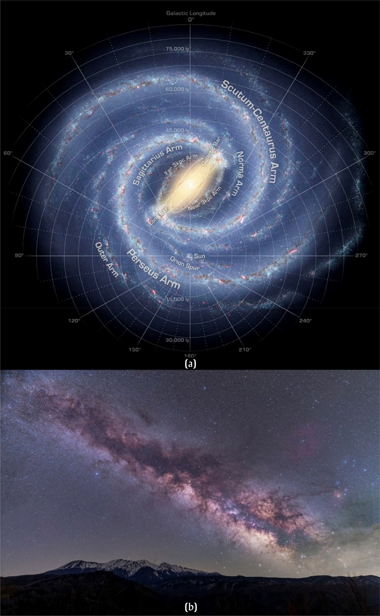
The term “Milky Way” comes from the Latin via lactea. In Classical Greek mythology, this heavenly band was formed from the splattered breast milk of the great goddess Hera, wife of Zeus, when she was tricked into suckling the infant hero-god Heracles (Roman Hercules). Today, astronomers know the Milky Way as a massive, rotating, barred spiral galaxy of gas and interstellar dust (Figure 2a) in which our solar system—our Sun and its orbiting planets, including Earth—is embedded. Modern science tells us that the Milky Way galaxy was formed about 13 billion years ago, 8 billion years after the “Big Bang” (Xiang and Rix Reference Xiang and Rix2022). It may incorporate as many as 400 billion stars and planets (a recent mapping effort identified 3.32 billion; Saydjari et al. Reference Saydjari, Schlafly, Lang, Meisner, Green, Zucker, Zelko, Speagle, Daylan, Lee, Valdes, Schlegel and Finkbeiner2023), and it is surrounded by a halo of invisible “dark matter,” a major component of cosmic structure (see, e.g., Baudis Reference Baudis2017; Wechsler and Tinker Reference Wechsler and Tinker2018). The dark-matter halo includes dense stellar formations known as “globular clusters,” which give the spiral disk its bumpy edges and are also visible in the bright stripe across the sky as viewed from Earth (Figure 2b). Because the galaxy is approximately disk shaped and we on Earth are in one of its four spiral arms in the same plane as the disk, we see it edge-on as a bright, lumpy, irregular band rather than as something that covers the sky completely.
The Milky Way: (a) artist's reconstruction of the spiral galaxy (courtesy of NASA/JPL-Caltech/R. Hurt [SSC/Caltech]); (b) photograph of the lumpy, starry band across the night sky (Kota Hamori, unsplash.com-photos-i3iCSXTjzTA).

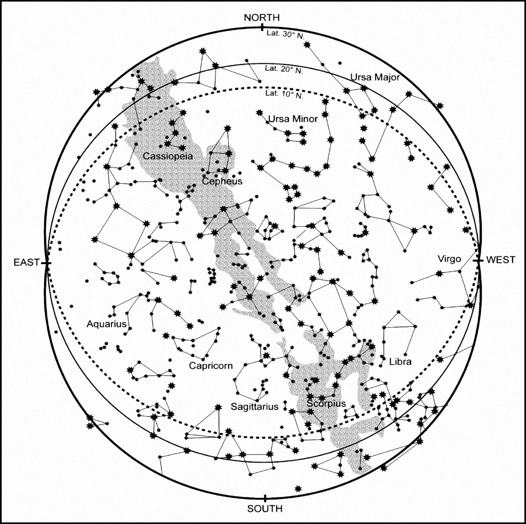
The Milky Way appears to move during the night and throughout the year as a result of Earth's continuous motion: 24-hour rotation on its tilted axis while orbiting the Sun in 365.24 days. It presents most dazzlingly as a wide, north–south ribbon arching across the sky, but it also may lie on the horizon. In addition, the visible galaxy displays intermediate orientations during any 24-hour or 365-day period, which vary depending on the latitude of the observer as well as the time of observation. For example, at dusk on or around the equinoxes, the Milky Way stretches overhead: southeast to northwest in the northern hemisphere's spring, and southwest to northeast in the fall (Figure 3; see Milbrath Reference Milbrath1999:288–291). At summer solstice, it rests on the eastern horizon.
Examples of the night sky at latitudes 30°, 20°, and 10° N, at dusk near the fall equinox and at different times from April through October (the rainy season). The Milky Way (stipple) arches from northeast to southwest, with the Great Rift (center; see text)—the open mouth of the “cosmic monster” or “celestial serpent”—pointing downward toward the southern horizon. After Milbrath Reference Milbrath1999:Figure 7.8A.

Technically, all the stars we see in the sky and all the constellations (asterisms) our imaginations conjure from stellar arrangements are in the Milky Way, because our solar system is encapsulated within it. A bright “central bulge,” a cluster of densely packed stars, is evident near the constellation Sagittarius in the galaxy's center, the point of rotation of its four arms. The dates of visible “risings” and “settings” of some of its especially bright stars, such as Alpha Sagittarii and Scorpius, have been determined vis-à-vis Earth's horizon at latitude 21° N (Merida, Yucatan, Mexico), at intervals of 500 years going back to 500 b.c. (Aveni Reference Aveni2001:Table 10). Over these 2,500 years, chronological slippage—called “precession” (delays or differences largely caused by slow changes in the orientation of a body's rotational axis)—can be traced. This means that rising or setting dates during the Preclassic period around 1000 b.c. would have been only a few days before those of 500 b.c. (for Classic-period [eighth-century] risings and settings at dawn, see Milbrath Reference Milbrath1999:Table 7.2). Seasonality is roughly preserved.
The ancients knew nothing of our twenty-first century science, of course. The Maya viewed almost all natural phenomena, especially celestial (Sun, Moon, stars), as animate beings: they moved, after all, crawling or dancing, alone or with partners, through the great void overhead. Worldwide, the Milky Way has been interpreted in myriad ways, particularly with reference to the Great Rift—a dark, linear area that divides part of the visible galaxy lengthwise. This rift consists of dust clouds between the arms that obscure many stars and prompts imaginative perceptions. Many peoples envision dark and light areas of the visible galaxy as significant animals in their earthly—especially riverine—environments (e.g., a shark, serpent, emu, kangaroo, llama) and embellish them in their creation myths and cosmologies (Gullberg et al. Reference Gullberg, Hamacher, Martín-Lopez, Mejuto, Munro and Orchiston2020; Romain Reference Romain2021). Among indigenous New World cultures, the Milky Way may have been identified as a path to the otherworld in a pan-hemispheric concept linked to deep and ancient traditions of shamanism (Barnhart Reference Barnhart2003). Contemporary Mayan speakers, for example, typically see the Milky Way as a path or road (sak be/bih, “white road”), often associated with the dead (Freidel et al. Reference Freidel, Schele and Parker1993:76; Milbrath Reference Milbrath1999:40–41; also Barnhart Reference Barnhart2003).
The ancient Maya may have interpreted the Milky Way as “a misty, celestial river with a crocodile swimming in it” (Bassie-Sweet Reference Bassie-Sweet2021:51, following Schele). Schele (in Freidel et al. Reference Freidel, Schele and Parker1993:85–100; also Milbrath Reference Milbrath1999:249), who studied the changing positions and orientations of the Milky Way at different times of the year, saw in the east–west Milky Way a “Cosmic Monster” or crocodilian creature (others envision a celestial serpent), with the Great Rift as its open jaws (Figure 3). At other times, it may have been a cosmic or world tree (wakah chan; north–south) or a canoe heading to the watery underworld of death. Comparable concepts—world tree, canoe, river, path to the realm of the dead (Maya Xibalba)—can be found in other cosmologies (e.g., Gullberg et al. Reference Gullberg, Hamacher, Martín-Lopez, Mejuto, Munro and Orchiston2020; Martín-López and Giménez Benítez Reference Martín-López and Giménez Benítez2008; Romain Reference Romain2021).
E Groups
The Mesoamerican architectural complex known as an E Group consists of two buildings, east and west, facing each other across a plaza. On the east side is a low, elongated, north–south platform or range structure; on the west side is an edifice—conical or rectangular in some early complexes and a radial pyramid in later ones—roughly centered on the platform opposite. E Groups or very similar configurations are found throughout early (Formative/Preclassic) Mesoamerica, including not only the Maya Lowlands (Freidel et al. Reference Freidel, Chase, Dowd and Murdock2017) but also the adjacent Chiapas / Río Usumacinta basin area, the Gulf and Pacific Coasts, and the Mexican highlands. In the Chiapas/Usumacinta area, they are part of what is called the “Middle Formative Chiapas” (MFC) site pattern (Clark and Hansen Reference Clark, Hansen, Inomata and Houston2001).
Although the term “E Group” comes from a relatively late (Early Classic; A.D. 200–600) structure pairing at Uaxactun (Peten), the prototype of this arrangement and the MFC pattern was said to be found at Ojo de Agua, Chiapas, dating around 1200–1000 b.c. (Inomata et al. Reference Inomata, Fernandez-Diaz, Triadan, García Mollinedo, Pinzón, Melina Garcia, Atasta, Ashley, Timothy, Gregory W.L., Juan Javier, Antonio Guerra, Luis Guerrero, Maria de Lourdes and Manuel Moreno2021:1494). Recent work by Takeshi Inomata and colleagues in the Gulf Coast region of Veracruz and Tabasco, Mexico (see Figure 1), has led to the discovery of even earlier complexes through lidar surveys. Beginning about 1400 b.c., standard architectural plans in the area include narrow, rectangular layouts; either large, raised, plateau-like platforms (e.g., at Aguada Fénix); or open plazas, oriented slightly east of north–south, with numerous variants (Inomata et al. Reference Inomata, Fernandez-Diaz, Triadan, García Mollinedo, Pinzón, Melina Garcia, Atasta, Ashley, Timothy, Gregory W.L., Juan Javier, Antonio Guerra, Luis Guerrero, Maria de Lourdes and Manuel Moreno2021). E Groups may be constructed in the centers of these plazas: the well-known Gulf Coast Olmec sites of San Lorenzo (Veracruz; Early Preclassic, 1800–800 b.c. [Hirth et al. Reference Hirth, Cyphers, Cobean, De León and Glascock2013]) and later La Venta (Tabasco; Middle Preclassic, ca. 800–400 b.c.) exhibit this general north–south linear pattern with E Groups. Traits of the underlying bedrock of the E Groups and other structures are not discussed.
The earliest radiocarbon-dated E Group known thus far in Peten is that at Ceibal in the southwest, dating to approximately 950 b.c. (Inomata et al. Reference Inomata, Triadan, Aoyama, Castillo and Yonenobu2013; Inomata et al. Reference Inomata, MacLellan, Triadan, Munson, Burham, Aoyama, Nasu, Pinzón and Yonenobu2015). Other Peten E Groups have comparable dates based on the presence of “Pre-Mamom” pottery—that is, pottery predating the widespread Middle Preclassic Mamom ceramic complex beginning approximately 900/800 b.c. At Tikal, both structures of the Mundo Perdido E Group began to be built atop leveled, elevated bedrock in Mamom Middle Preclassic times (Laporte and Fialko Reference Laporte and Fialko1995; Montuori and Rosado Torres Reference Montuori and Rosado Torres2021). The eastern platform, constructed upon a “floor” (presumably of plaster), began as a three-tiered structure measuring 42 by 11 m, oriented approximately north–south. No signs of underlying sculpted bedrock are reported. Deposits in chultunes (pits excavated into limestone bedrock) included the remains of feasts and other activities, and more than 20,000 Pre-Mamom sherds (Cheetham et al. Reference Cheetham, Forsyth, Clark, Laporte, Arroyo, Escobedo and Mejía2003:612). At Cival to the northeast, the E Group in the site epicenter had a burial with Pre-Mamom sherds in the surrounding fills (Estrada-Belli Reference Estrada-Belli, Freidel, Chase, Dowd and Murdock2017:297–298). At Nixtun-Ch'ich' on the western end of Lake Peten Itza, construction of two E Groups—Groups AA1 and Y1—began in the Yum (Pre-Mamom-to-Mamom) Transition at about that same time (see below).
Unfortunately, in only a relatively few cases (e.g., Tikal and Uaxactun in Peten) have both structures of the E Group complexes been extensively excavated to investigate their histories, and most work has focused on the eastern platforms. In Peten, excavations revealed that these latter were often constructed on low limestone bedrock or marl knolls, or they incorporated such rises at their core. The bedrock was typically cleaned and sometimes carved:
• At Cenote, in the Lake Peten Itza basin, the earliest form of the E Group “was constructed of carved bedrock. Under the eastern platform, oriented very slightly northeast–southwest, bedrock was shaped as a stepped platform complete with lower side wings” (Chase and Chase Reference Chase, Chase, Freidel, Chase, Dowd and Murdock2017:47; also Chase Reference Chase1983:92).
• At Cival, the earliest E Group was created of bedrock after first stripping away surface soil; the eastern platform in the Cenote style (see below) was “a modified limestone knoll into which the steps of a central stairway were carved” (Estrada-Belli Reference Estrada-Belli, Freidel, Chase, Dowd and Murdock2017:296, 303, also Reference Estrada-Belli2011:74–75).
• At Ceibal, “residents made a plaza by scraping off humus and carved the earliest E Group buildings out of the natural marl” (Inomata Reference Inomata, Freidel, Chase, Dowd and Murdock2017:220). The Cenote-style (see below) eastern structure “was entirely made of carved marl . . . and it apparently did not support any superstructures. As such, the eastern building . . . looked more like a raised edge of the plaza” (Inomata Reference Inomata, Freidel, Chase, Dowd and Murdock2017:223).
In sum, the lowest levels of these eastern structures in lowland E Groups reveal vestiges of early, pre-constructional, ritual activity: ancient Maya placemaking, creating “Early Ritual Areas” (Rice Reference Rice, Freidel, Chase, Dowd and Murdock2017). This began with clearing soil off a small bedrock knoll to expose a clean white surface, which was sometimes sculpted.
The axial orientations of these early configurations everywhere are of interest, and their alignments vary. E Group orientations can be determined in two ways: by the azimuth of the axis of the centers of the western and eastern structures, or by the azimuth of the long axis of the eastern platform. These are roughly orthogonal, the primary axis of the eastern structure being north–south, although significant variations exist and the west–east axis is not always precisely perpendicular (see Aveni et al. Reference Aveni, Dowd and Vining2003; Šprajc Reference Šprajc, Dowd and Milbrath2015). The north–south orientation of the eastern structure is primarily pivoted clockwise, toward northeast–southwest. Counterclockwise rotations from north are present but less common. Multiple spatiotemporal variants of the general north–south linear pattern have been documented, but this preferred orientation is evident from the earliest appearance of E Groups in the Early Formative Gulf Coast region (Inomata et al. Reference Inomata, Fernandez-Diaz, Triadan, García Mollinedo, Pinzón, Melina Garcia, Atasta, Ashley, Timothy, Gregory W.L., Juan Javier, Antonio Guerra, Luis Guerrero, Maria de Lourdes and Manuel Moreno2021). There, most of the newly identified assemblages are oriented between -10° azimuth (slightly west of North) and 30° (east of North), especially around 6° to 20° (Inomata et al. Reference Inomata, Fernandez-Diaz, Triadan, García Mollinedo, Pinzón, Melina Garcia, Atasta, Ashley, Timothy, Gregory W.L., Juan Javier, Antonio Guerra, Luis Guerrero, Maria de Lourdes and Manuel Moreno2021). The eastern structures of some later sites’ E Groups give evidence of groups or families of alignments, such as a 14° azimuth (e.g., Aveni and Hartung Reference Aveni and Hartung1986:17, 54–55, Reference Aveni, Hartung and Keber2000:55). In the Maya area, this east-of-north orientation of structures in general, not solely those in E Groups, was a persistent architectural and spatiotemporal tradition, with 84 percent of Preclassic and Classic cities in one study displaying this axis (Aveni and Hartung Reference Aveni and Hartung1986).
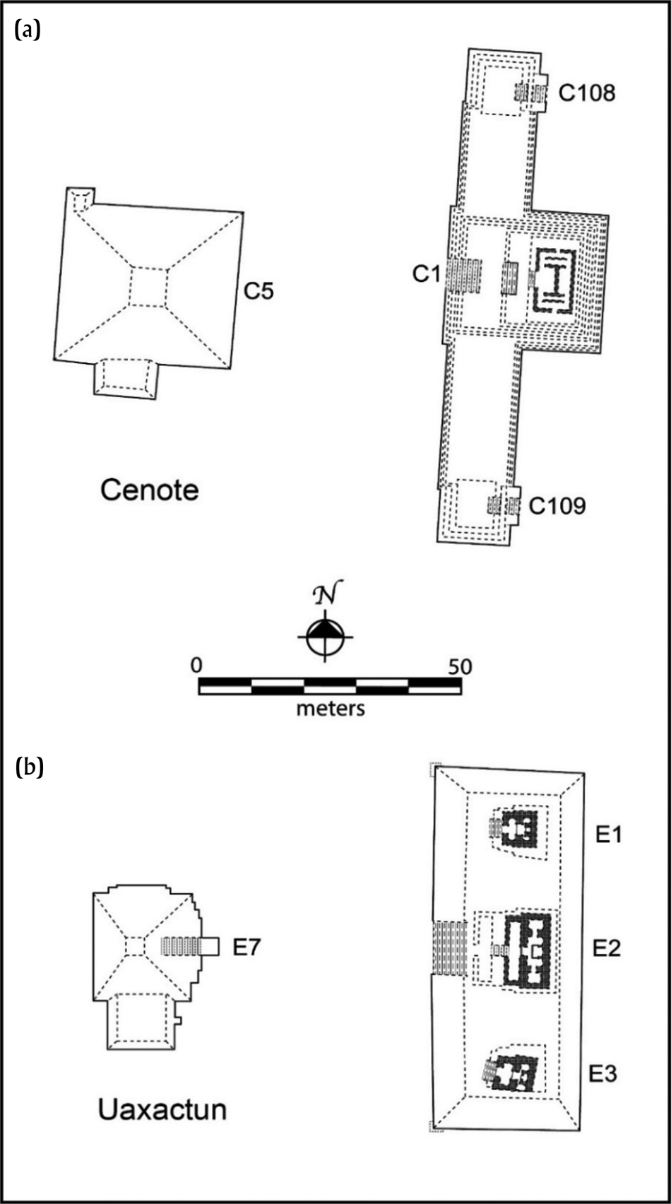
Middle Preclassic E Groups are considered the earliest formal and standardized architectural complex in the Maya Lowlands (Chase et al. Reference Chase, Dowd, Freidel, Freidel, Chase, Dowd and Murdock2017:8), but they present considerable variation. For example, in central Peten, the eastern platforms typically are tripartite, with three conjoined structures or superstructures, and they occur in two variants: “Cenote style” and “Uaxactun style” (Chase Reference Chase1983; Chase and Chase Reference Chase, Chase, Freidel, Chase, Dowd and Murdock2017). In the Cenote style (Figure 4a), the central edifice sits slightly back (east) from the north–south axis of the platform, and low wings extend to smaller structures at the north and south ends, each with a rear (east) stairway. In the Uaxactun style (Figure 4b), the three buildings are in-line superstructures atop a single platform accessed by a central front (west) stairway. The eastern platforms of the earlier E Groups around the Gulf Coast lack superstructures, although at least one has a rear stair (Inomata et al. Reference Inomata, Fernandez-Diaz, Triadan, García Mollinedo, Pinzón, Melina Garcia, Atasta, Ashley, Timothy, Gregory W.L., Juan Javier, Antonio Guerra, Luis Guerrero, Maria de Lourdes and Manuel Moreno2021:Figures 2 and 4).
Examples of E Groups in Peten: (a) Cenote style; (b) Uaxactun style. After Chase and Chase Reference Chase, Chase, Freidel, Chase, Dowd and Murdock2017:Figures 2.1, 2.2, and 2.4.

Lowland E Groups survived for centuries, with refurbishing and rebuilding leading to marked changes in form (see, e.g., Mundo Perdido at Tikal; Laporte and Fialko Reference Laporte and Fialko1995). Overall, differences between the two Peten styles do not appear to be geographical (Aimers and Rice Reference Aimers and Rice2006:82) but rather chronological, at least in part: the Early Classic Uaxactun style is later than the Cenote style. In southeastern Peten, E Group complexes exhibit significant structural, metric, and chronological differences compared with the central area (Chocón Reference Chocón, Arroyo and Salinas2013).
E Groups’ functions: Observational astronomy?
The long recognized architectural similarities of Maya E Groups led to expectations that they had similar uses. Among the many suggested functions (see, e.g., Milbrath Reference Milbrath2017b), the most enduring centers on eastern horizon–based solar observational astronomy and timekeeping. As remarked by early archaeologists studying the newly discovered (but late dating) Uaxactun E Group (Blom Reference Blom1924; Ricketson Reference Ricketson1928; Ruppert Reference Ruppert, Hay, Linton, Lothrop, Shapiro and Vaillant1977[1940]; see also Cohodas Reference Cohodas1980), positions of the sun at sunrise, viewed from the western pyramid, appeared to coincide with points (corners, rooflines, etc.) on the three eastern superstructures at the solstices and equinoxes. But it is now evident that the earliest eastern-range structures—or the early stages of their construction—were simple, flat platforms; the three conjoined buildings or superstructures were later modifications. At Tikal, the superstructures began to be built in the Early Classic period (Montuori and Rosado Torres Reference Montuori and Rosado Torres2021). If the open early platforms had the proposed observational functions, wooden poles or stone slabs might have been placed to mark positions of celestial (solar, lunar, astral) risings, as with the basalt pillar (possibly one of three) on La Venta eastern Structure D-8 (see Drucker Reference Drucker1952:9).
The observation/timekeeping explanation of E Groups was bolstered when Anthony Aveni (Reference Aveni2002:211; Aveni et al. Reference Aveni, Dowd and Vining2003) noted that around 17° N latitude (that of the Peten lakes), the solar year can be “perfectly segmented into multiples of 20 days,” each ending on a solstice, equinox, or zenith/nadir passage. Twenty days is the Maya winal calendrical unit—roughly a “month.” The implication is that this latitudinal zone would have been fertile ground for development or elaboration of the Maya sacred almanac of 260 days: 13 numerals × 20 named winal days (see also Milbrath Reference Milbrath, Freidel, Chase, Dowd and Murdock2017a). A significant role of E Groups in astro-calendrical cycling (Aimers and Rice Reference Aimers and Rice2006:87–92; Aveni and Hartung Reference Aveni, Hartung and Aveni1989; Chase and Chase Reference Chase and Chase1995) appears to have continued through the Early Classic period, when some of the earliest dated stelae were erected in front (west) of the eastern platforms to celebrate completion of 20-year periods known as k'atuns or winikhaabs. Some E Groups may have commemorated completion of 400-year bak'tun cycles (Chase and Chase Reference Chase, Chase, Freidel, Chase, Dowd and Murdock2017).
But several factors impinge on the solar-observational explanation, including variable visibility of the “natural horizon” resulting from the height of nearby structures, weather, topography, and vegetation. Low ground fog often shrouds the morning landscape until the sun burns it off, and cloud cover increases during the rainy season (June through October or later), although it typically disappears overnight. The limestone karst terrain is uneven, with hills and ridges interrupted by rivers, streams, and low, swampy areas (bajos). Except in certain areas, the visibility of the horizon is now—and would have been in Preclassic times—limited by the height and proximity of the lush tropical forest. These features, alone or in combination, might have obstructed views of the horizon and the rising or setting of stars, although not the sky overhead. Unsurprisingly, a viewshed analysis of Peten E Groups suggested they were carefully situated on elevated areas (Doyle Reference Doyle2012).
Moreover, variations from site to site in basic orientations of the assemblage, and particularly that of the eastern platform, have posed problems for hypotheses of solar stations. After an exhaustive analysis of azimuths and declinations of 71 central lowland Maya E Groups, Šprajc (Reference Šprajc2021) concluded that, although the central (east–west) axes of these arrangements were long maintained, there were no convincing astronomical explanations for the lateral structures, and “it is highly likely that astronomical criteria did not dictate the orientation of each and every E Group.” In addition, although the general positioning of the western pyramid opposite the central eastern structure suggests a focus on equinoctial sunrises (see Chocón Reference Chocón, Arroyo and Salinas2013:523, Figures 6–8; also Cohodas Reference Cohodas1980), such dates are difficult to define by observation alone. Instead, the west-to-east alignments appear to register “sunrises and sunsets on agriculturally significant dates” and possibly also “quarter days”—rough approximations of equinoxes by halving counts of days between solstices (Šprajc Reference Šprajc2021).
Still other possible astronomical relationships suggest nonsolar phenomena: alignments to the Moon, Venus, or other stars or asterisms. Cival, for example, had five E Groups, perhaps dedicated to varied astro-calendrical cycles (Estrada-Belli Reference Estrada-Belli, Freidel, Chase, Dowd and Murdock2017:320). Or, perhaps the display of hierophanies “via the subtle interplay of light and shadow in the architecture” was the aim (Aveni and Dowd Reference Aveni, Dowd, Freidel, Chase, Dowd and Murdock2017:88). Or “astronomical commemoration” was the intention (Fialko Reference Fialko1988), the three structures being metaphorical solar stations, in which case precision did not matter. Or, perhaps twentieth-century astronomical/solar explanations have been driven by “Western” traditions and biases, which can be traced back to the early Spaniards (May Castillo Reference May Castillo2018). In these hermeneutical reflections, based on analogy to today’s ch’a chaak (rain bringing) rituals in Yucatan, E Group ceremony took place in the daytime. The creation hypothesis proposes that the ceremonies took place at night, recreating the primordial darkness before the Sun emerged. Perhaps they were scheduled on the nights before sunrise on agriculturally significant dates.
As the robusticity of the observational astronomy explanation is increasingly questioned, other functions have been proposed, based on geographical associations with trade routes (Laporte et al. Reference Laporte, Adánez and Mejía2008; Stanton Reference Stanton, Freidel, Chase, Dowd and Murdock2017) and watersheds (Chase and Chase Reference Chase, Chase, Freidel, Chase, Dowd and Murdock2017:34). Various kinds of ceremonial activity also have been suggested, including general agricultural ritual (Cohodas Reference Cohodas1980), solar stations on “agriculturally significant dates” (Šprajc Reference Šprajc2021), and maize-based ritual (Rice Reference Rice, Freidel, Chase, Dowd and Murdock2017:158; Stanton and Freidel Reference Stanton and Freidel2003), all of which have implicit referents in seasonal cycling and rainfall. Other ceremonial functions relate to mortuary or ancestor veneration ritual as seen at Cival (Estrada-Belli Reference Estrada-Belli, Freidel, Chase, Dowd and Murdock2017:297), Tikal (Laporte Reference Laporte and Sabloff2003; Laporte and Fialko Reference Laporte and Fialko1995), and the Belize valley (Awe Reference Awe2013; Awe et al. Reference Awe, Hoggarth, Aimers, Freidel, Chase, Dowd and Murdock2017:432–435; Brown Reference Brown, Freidel, Chase, Dowd and Murdock2017). The presence of multiple E Groups at various sites—five at Cival and three at both Nixtun-Ch'ich' and Yaxha—might indicate that certain kin groups built these complexes to proclaim their politico-ritual importance and power, perhaps in particular neighborhoods or sectors of the communities.
E Groups, the Milky Way, and creation
Regardless of the variability in eastern structure form, size, orientation, and date, the similarities among E Groups are generally emphasized over the differences, and they are seen as examples of a widely shared, unified belief system materializing Maya deep history (Chase and Chase Reference Chase, Chase, Freidel, Chase, Dowd and Murdock2017). If E Groups exemplify an early shared belief system, what was that system, or its core tenets, in Maya communities’ histories? How was it materialized by E Group architectural arrangements? I suggest that this belief system and deep (i.e., mythical) history centered on cosmology and cosmogony: stories about creation, about the origins of the universe and of life and of time, focused on the Milky Way.
It is easy to imagine the Maya creation stories as public ritual performances and pageantry that promoted group cohesion, social integration, and community identities. These could be presented in multiple “acts” incorporating processions, dance, singing, and oratory, enhanced with physical, visual, and musical components. Early Maya E Groups, then, might have constituted ancient theaters for such performances (see Chase et al. Reference Chase, Dowd, Freidel, Freidel, Chase, Dowd and Murdock2017:18), with the eastern platform—symbolically the Milky Way—the stage for dramatic ceremonies re-enacting the events of creation.
The three eastern structures
The earliest lowland E Groups apparently consisted of only flat platforms, although they might have supported temporary or perishable features. At some point, however, the later Maya reconceived the eastern structures as tripartite, either as three conjoined platforms or with three superstructures. The reasons for this modification can only be guessed, but they suggest an important transformation in meaning and/or function of this edifice and perhaps of the E Group as a whole.
In terms of the Milky Way / creation proposal, these additions hint at a different conceptualization of this celestial phenomenon, or of creation itself, or of the performative content and context of creation ritual—or of some combination of these. The three architectural components might relate to changing emphases on the role of three beings, entities, or places, such as the three founding deities, known today as GI, GII, GIII (the Palenque Triad). In the Popol Vuh, the god Heart of Sky comprises three supernaturals: Thunderbolt Hurricane, Newborn Thunderbolt, and Raw Thunderbolt (Tedlock Reference Tedlock1996). Or, they might represent prominent stars or asterisms in the Milky Way that are visible from Earth. If so, the large middle structure would represent the brightest feature, the central bulge of the Sagittarius constellation or globular cluster, with Alpha Sagittarii the eponymous star. The two end buildings would represent major features at the north and south extremes of the Milky Way, their visibility dependent on the galaxy's positioning. The constellation Scorpio/Scorpius and its bright central star—reddish Antares—lie at the south end, which according to Maya myth also represents the watery underworld, the land of the dead.
In Maya myth, the northern part of the Milky Way, from Sagittarius through the constellation Orion (“The Hunter”), constitutes the Place of Creation and the Three Stone Place. It was here, on the Maya date 13.0.0.0.0 (or 0.0.0.0.0), that the gods set up the triangular arrangement of the three stones of the Maya hearth: the stars Alnitak, Rigel, and Saiph in Orion. This is the three-stone or three-stone-throne place described on Stela C at Quirigua: the Jaguar stone/throne/platform “planted” by the Paddlers, the Snake platform by an unknown deity, and the Water throne by Itzamna (Looper Reference Looper2003:158–160). Also, the three stars of Orion's belt (Alnitak, Alnilam, Mintaka) rose vertically in the east at the time of maize sprouting (Milbrath Reference Milbrath2017b:89). Moreover, the cluster of stars known as the Pleiades lies in the northern area. In Yucatán, the Pleiades are known as tzab, the rattle-tail of the feathered serpent supernatural called Kukulcan/Quetzalcoatl and identified with Venus (Milbrath Reference Milbrath1999:36, 38, 258). In 500 b.c., this asterism, closely associated by the Maya and other peoples with the start of planting (the Kiche' describe the Pleiades as a handful of corn), set in the evening in March and disappeared in early May (Milbrath Reference Milbrath1999:258, Table 7.4), but it was visible at dawn on June 13.
Maya interpretations of this section of the Milky Way emphasize planting and agriculture, and Carrasco (Reference Carrasco, Staller and Carrasco2010:602) suggests—following Rafael Girard—that maize and agriculture played a major role in Maya mythology: “within the ontology of myth, [astronomical phenomena] are secondary to agrarian and domestic practices.” He considers the three-stone domestic hearth to be both a “visual and literary symbol of the present creation” (Carrasco Reference Carrasco, Staller and Carrasco2010:603). It is not difficult to conceive of maize, the Mayas’ primary sustenance, as a key element of their creation myths: the first humans were said to have been formed of maize dough by the gods. Analysis of starch grains from stone tools recovered in northern Belize indicates processing of maize, beans, squash, manioc, and chili peppers as early as the Archaic period (Rosenswig et al. Reference Rosenswig, Pearsall, Masson, Culleton and Kennett2014:316–317). Maize was an important element of Early Formative / Olmec iconography; in Late Preclassic northeast Peten, the San Bartolo murals (Urquizú and Hearst Reference Urquizú and Hurst2011) show the Maize God being born from a mountain cave (in the Milky Way) and being dressed or “adorned” by young female attendants. It is not yet clear, however, when or how domesticated maize became sufficiently important as a dietary staple (or an elite food) among the Maya to play a major role in creation mythology.
Lake Peten Itza and Nixtun-Ch'ich'
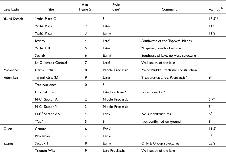
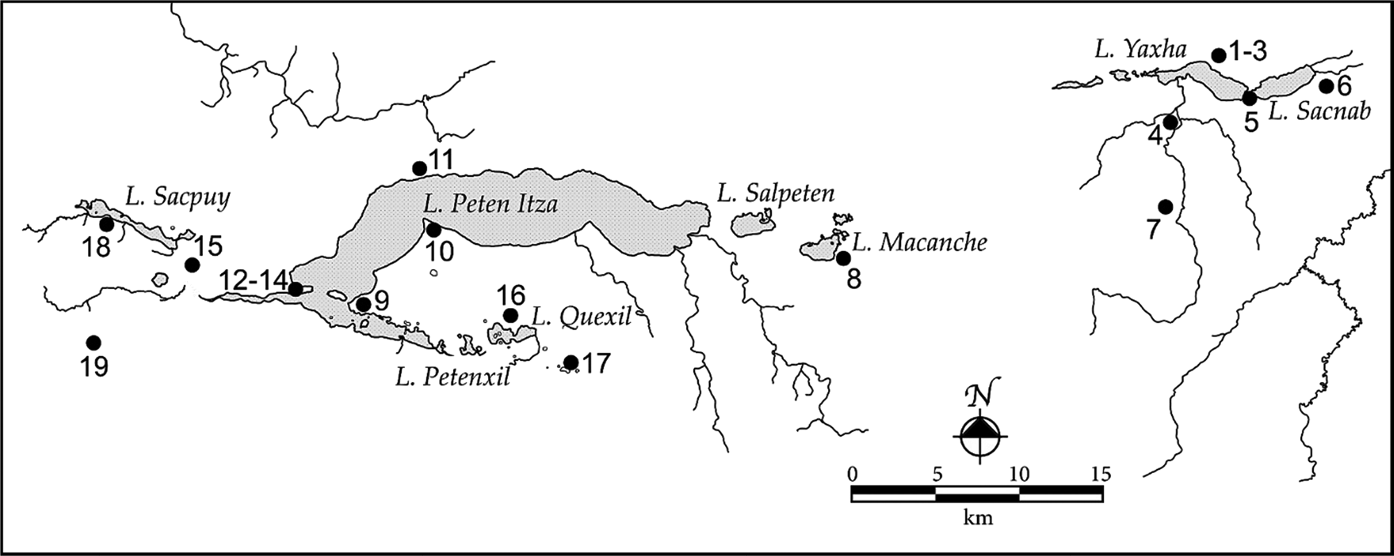
At least 20 E Groups or possible E Groups were built in the basins of the central Peten lakes, nine of them around the largest—Lake Peten Itza (Figure 5). Two early cities bookending the lakes chain, Yaxha in the east and Nixtun-Ch'ich' at western Lake Peten Itza, have three of these complexes, with others in nearby smaller centers (see Rice and Pugh Reference Rice and Pugh2021). Most remain unexcavated but, as noted, cleaned and carved bedrock was at the core of the eastern structure of the E Group at the site of Cenote, on the Tayasal Peninsula in Lake Peten Itza (Chase Reference Chase1983:92). The east–west axes of the central Peten E Groups correspond to sunrise on March 11 and October 2, and sunset (viewed over the western pyramid) on March 31 and September 12, identical to Tikal's Mundo Perdido (Šprajc Reference Šprajc2021:Figure 11). Azimuths of the eastern structures reveal clockwise deviations from North, primarily between 3° and 13° (Table 1). If these structures reproduce the Milky Way, they seem to memorialize the position of the celestial band when it arches overhead, N/NE–S/SW, in the first half of the night between July and September, including the autumnal equinox (Rey Reference Rey1962:Chart 14C). This is the rainy season, and the cleft/mouth of the celestial monster extended from overhead to the southern horizon (Figure 3), perhaps symbolically expelling rainwaters on Earth (Milbrath Reference Milbrath1999:288, 291).
E Groups and possible E Groups in the central Peten lakes’ basins, with azimuths of the eastern structures

a Style-dates with question mark rely on visual characteristics of standing architecture: Early? = Cenote style; Late? = Uaxactun style.
b From Aveni et al. Reference Aveni, Dowd and Vining2003:Table 1; Chase and Chase Reference Chase, Chase, Freidel, Chase, Dowd and Murdock2017; Timothy Pugh, personal communication 2021.
c Nixtun-Ch'ich'.
The central Peten lakes area, northern Guatemala, showing sites with E Groups (see Table 1 for identification of sites with numbers). Map by Don S. Rice.

Nixtun-Ch'ich' E Groups
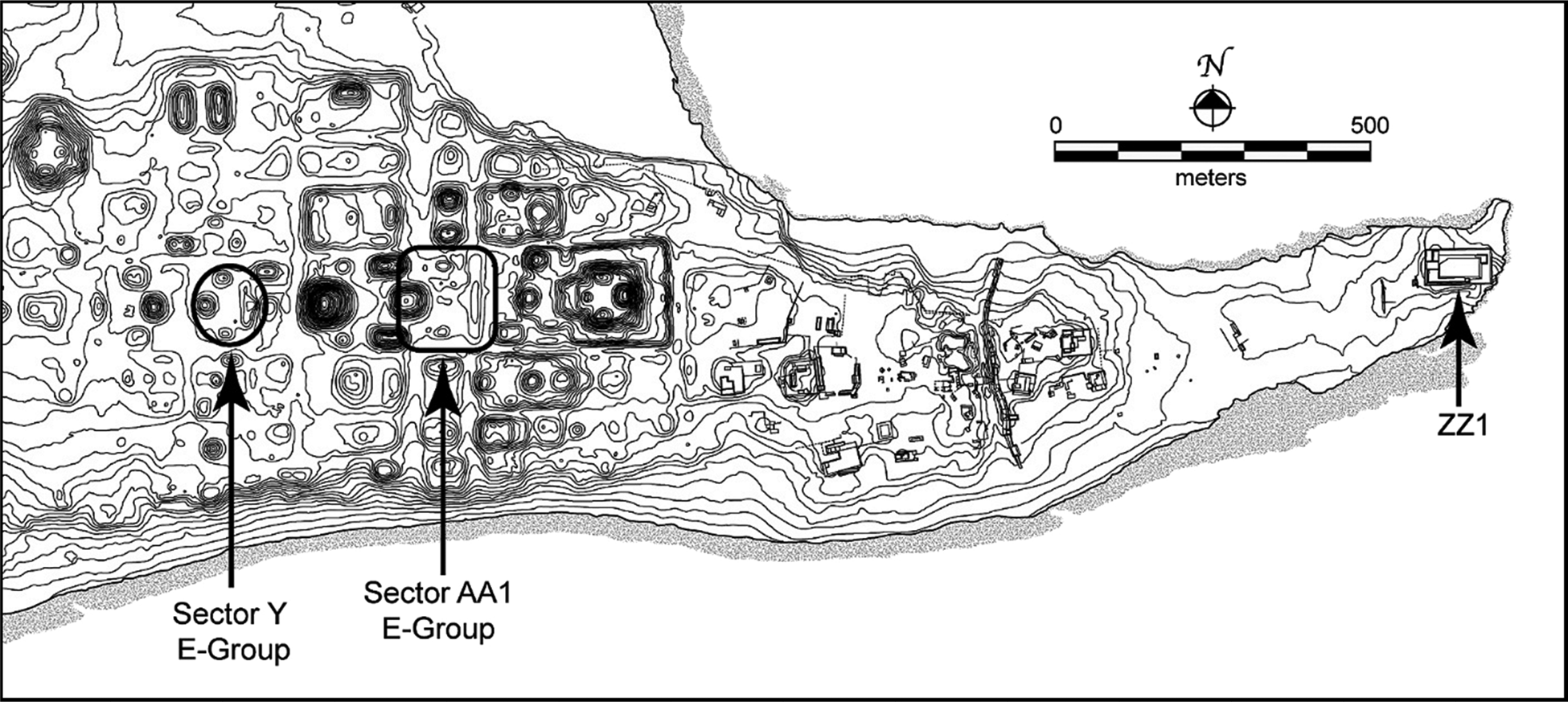
Three E Groups at the gridded city of Nixtun-Ch'ich' (Figure 6) lie on its central east–west axis (azimuth 95°). The westernmost, in Sector A, has not been excavated, but the other two, in Sectors AA and Y in the main civic-ceremonial core of the site, have been explored. Although no evidence of modification of a bedrock knoll has been found under their eastern platforms, the initiation of major construction of both was early and approximately coeval in “archaeological time”—that is, the transition from Early to Middle Preclassic periods.
Plan of the gridded site of Nixtun-Ch'ich', on the western edge of Lake Peten Itza, showing the location of the AA1 and Sector Y E Groups and Mound ZZ1. The third E Group, Group A, is off the map to the left/west. Map by Don S. Rice.

The easternmost complex in Sector AA is known only by its eastern platform (Structure AA1/1); a western structure, if it existed, was overbuilt by the large Structure AA2 pyramid. Structure AA1/1—136 m long and 2.5 m high above bedrock, with an azimuth of 6°—lacks evidence of the tripart configuration or superstructures. If once present, these might have been later destroyed, given that upper excavation levels revealed considerable Classic and Postclassic pottery. Of three test units, one into the northcentral part of the platform revealed a 30–35 cm thick deposit of mixed Pre-Mamom and early Middle Preclassic sherds (Yum Transitional ceramic complex, ~1000–800 b.c.) atop bedrock, covered by 70 cm of Middle Preclassic fill (Rice et al. Reference Rice, Cordell, Kidder, Harris, Pugh and Nieto2018:755, Figure 2).
The Sector Y E Group was built upon a large, substructural platform (Structure Y1). Structure Y1/1, the eastern range structure, is 83.5 m long, about 2.5 m high above the present plaza surface and oriented 3° east of North. A test unit placed on the western (front) centerline of this building revealed part of the construction history of the substructural platform, beginning with a 50 cm thick deposit incorporating Pre-Mamom pottery on bedrock (Rice et al. Reference Rice, Pugh and Nieto2019). Eight subsequent episodes of early Middle Preclassic construction were capped by a floor (Floor 6), above which were the patchy remains of Late Preclassic plaza surfacing that butted up to a central stairway scaling Y1/1's western (front) face. Two intrusive features were noted on the east–west centerline: an oval pit, perhaps where a stela had been placed and removed, and a partial human cranium. The final construction involved three superstructures on a single platform accessed by a front stairway. The central of these, Structure Y1/1-1, dated to the Terminal Classic or Postclassic period and had a rear (east) inset stairway of six steps. Excavations suggested that the original Y1/1 platform began as a narrow (~8 m east–west), stepped and terraced structure of indeterminate length, later greatly widened to the east or back. Massive stone fill precluded deep soundings because of the danger of collapse, so the characteristics of underlying bedrock are unknown.
The Sector Y E Group was paired with a deep depression (Fosa Y) to the east. Probably a natural sinkhole and a portal to the Maya underworld, Fosa Y was the anchor of the city's central axis urbis and its grid (Pugh and Rice Reference Pugh and Rice2017). The early raising of the E Group immediately to its west, with a stairway from the eastern platform descending to the fosa, accentuates the importance of this location as a sacred “mountain–spring” shrine, similar to the Olmec El Manatí site (Diehl Reference Diehl2004:26).
“Testing” the Milky Way / creation hypothesis
The broad geographical spread and protracted constructional histories of lowland Maya E Groups suggest that these arrangements were of profound cultural importance, but their functions, presumably widely shared, are incompletely understood. The architecture, impressive as it is, is functionally ambiguous. Moreover, as in archaeology in general, it is difficult to “prove” any interpretations of past behavior or beliefs; even radiocarbon dates have standard error ranges. The best one can do is try to amass supportive evidence from various sources and search for disconfirmatory data.
Here, the issue of interest concerns the much-debated purposes and uses of the E Group eastern platform, with its three late superstructures. The platforms might have functioned alone or with their western companion at different times. Multiple functions—mostly ritual, but with different foci—have been suggested: astronomical observation, mortuary/ancestor-veneration, trade agricultural/maize. Others propose general commemorative roles. Few of these propositions, bullletted here, have been framed as testable hypotheses:
• The astronomical explanation has been rigorously tested through celestial alignments and orientations. Some data are supportive and/or need modification; other data suggest that alternatives are necessary.
• Mortuary functions are, de facto, at least partially correct, as shown by the uncovering of burials or human remains in some eastern structures.
• The agricultural hypothesis of E Group function has been strengthened by testing the astronomical explanation: instead of uniformly pointing to solar stations, the west-to-east alignments appear to register “sunrises and sunsets on agriculturally significant dates” (Šprajc Reference Šprajc2021). Moreover, the cluster of stars known as the Pleiades, often a marker for the start of planting, lies in the northern area of the Milky Way.
• Several lines of evidence provide circumstantial support for the Milky Way / creation hypothesis: known Maya creation myths, discussed above, relate characters and events that occurred in the Milky Way.
• Support for the creation part of the proposal can be drawn from ethnographic analogy: lowland Maya E Groups might have played roles in ancient communities analogous to the 10 cofradía (religious brotherhood) houses in Santiago Atitlan, in western highland Guatemala. These
…represent the abodes of sacred ancestors and gods. These are not just symbolic representations of sacred mountains. They are, in a sense, the first mountain where creation first took place . . . a focal point for regenerative power . . . . Each is a place of origin in the sense that ritual activity conducted there opens a portal not only into sacred space but also into sacred time. Participants in these ceremonies consider themselves to be present at the moment of first beginnings when their gods and ancestors set the pattern for the world's existence. Such regeneration allows the Maya to periodically re-birth their world . . .in harmony with sacred order. Such ceremonies are considered essential to the very existence of the world (Christenson Reference Christenson and Staller2008:119).
How might the Milky Way/Creation hypothesis of E Group function be “tested” archaeologically? Here are some possibilities:
• Data might be sought through more intensive excavations of both superstructures and substructures of the eastern platforms. Precise measurements of the azimuths of the earliest platforms over bedrock would be useful. Did they change with refurbishing? If so, can they be identified with different times/seasons of observing the Milky Way? Do they preserve associations with the rainy season?
• Might the three superstructures have been decorated to enhance their identification with the sky bodies in accordance with whatever public activities were taking place? Recall that the northern Milky Way is the place of creation per se, whereas the southern part leads to the Underworld of Death. Do different kinds or styles of artifacts occur at, in, or around the three structures, corresponding to myth—agriculture (or three hearth stones) in the north, death/underworld in the south? Movable props—for example, real corn plants or representations of them—might have been placed appropriately.
• Were caches placed in the platform or superstructures, as opposed to the plaza? At Uaxactun, for example, two types of in-floor caches were noted in all three superstructures: (1) lip-to-lip redware dishes holding the skull of a sacrificed individual, and (2) lidded cylinders, one of which held an “’archaic’ green mudstone human figurine” (Ricketson Reference Ricketson1933:78). Caches might support mythic associations if different materials were cached in the north, central, and southern parts—such as agricultural implements or seeds in the north, or water symbols (e.g., shell, jade) in the south.
• Might there be unrecognized architectural parallels to the Milky Way's dark rift, such as depictions of serpents or the cosmic monster beheaded by the gods?
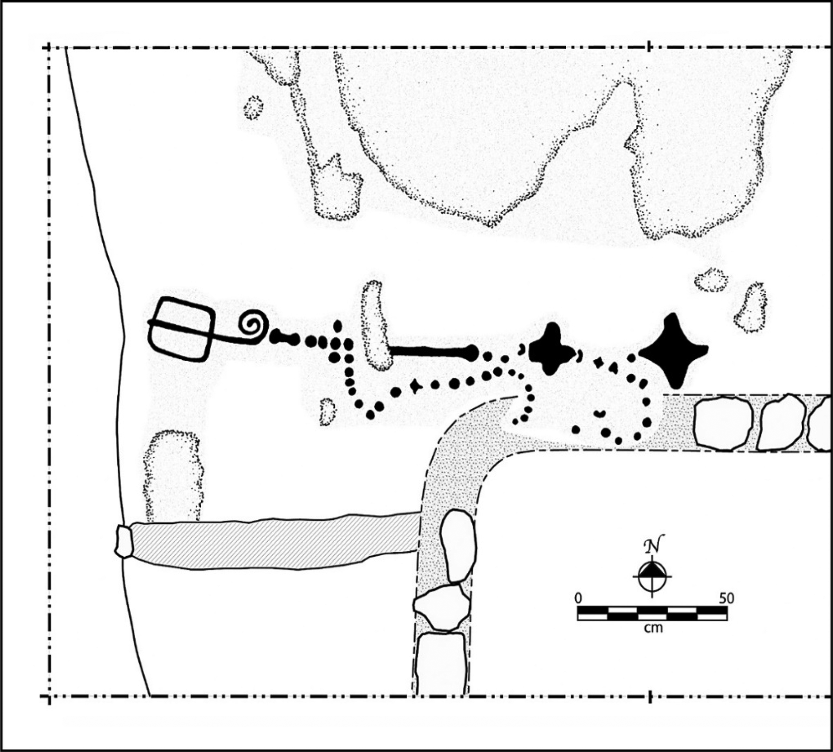
• Inscriptions, such as the enigmatic pecked design on a Preclassic floor of Nixtun-Ch'ich' Structure ZZ1 (not part of a recognizable E Group), might support celestial affinities. That linear design, approximately 1.9 m long (Figure 7), consisted of a skyband-like arrangement of lines of dots, two four-pointed star-like elements (the main sign of lamat/ek’, ‘star, Venus’), and three tiny crescents.
Pecked design in the plaster floor capping Late Middle Preclassic Structure B-2 at Nixtun-Ch'ich' Mound ZZ1. The northwest foundation of Structure B-1 is seen in the lower right corner of the figure. After Rice Reference Rice2009:Figure 11.

The problem with many of these possibilities for “testing” the hypothesis is that embellishments of the platform or superstructures to accentuate celestial and/or mythical affinities could have been painted, sculpted, or created with perishable materials such as textiles, basketry, animal skins, and plant matter. If this were the case, preservation issues severely constrain testing and explanation.
Concluding thoughts
The Preclassic lowland Maya adopted and transformed the iconic architectural assemblages later known as E Groups from their Gulf Coast neighbors. This borrowing, before or around 1000 b.c., accompanied other major changes in the lifeways of lowland peoples, including growing reliance on maize agriculture, permanent settlement, population growth, and more formalized ritual/religious and hierarchical sociopolitical organization. These monuments, consisting of only two structures—eastern and western—exhibit considerable variability in both their physical appearance and axial orientations.
The long-lived Maya E Groups are thought to represent a shared belief system materializing mythic histories. I propose that the low eastern platform, oriented roughly north–south, was an earthly recreation of what we know today as the Milky Way. This broad, glowing, white band arching across the night sky must have captured the attention and imagination of early peoples seeking to understand and explain the mysteries of their world. A key role for the Milky Way in the conceptualization of the E Group eliminates the problems with the solar-observational hypothesis caused by difficulties in viewing the horizon because of fog, clouds, trees, topography, or other structures: the Milky Way was, instead, often high in the sky and therefore readily seen. The Milky Way was the otherworldly setting for Maya origin myths, and the early eastern platforms can be envisioned as stages for performances of their creation stories. E Groups are therefore examples of what Carrasco (Reference Carrasco, Staller and Carrasco2010:620) called “the sacred architecture of Creation.”
The very early dates of these E Groups, or at least their eastern platforms, raise the likelihood that components of this arrangement have roots in Early Preclassic public ritual and architecture of the Gulf Coastal region. There, the long edges of the early plazas were sometimes lined with 20 platforms—10 per side—and thought to date to that region's Early Formative apogee (Inomata et al. Reference Inomata, Fernandez-Diaz, Triadan, García Mollinedo, Pinzón, Melina Garcia, Atasta, Ashley, Timothy, Gregory W.L., Juan Javier, Antonio Guerra, Luis Guerrero, Maria de Lourdes and Manuel Moreno2021:Figure 4). These might reproduce the clusters of stars creating the bumpy edges of the Milky Way visible from Earth (Figure 2b). Or, they might register architecturally the development of the 260-day “calendar,” with its 20 day names.
The early dates also suggest wide sharing of belief systems and rituals among the semisedentary, semihorticultural peoples of the region. Analogies drawn from middle range or tribal groups in other times and places indicate that such sharing was facilitated by their mobility and the seasonal or situational forming of larger settlement aggregations. During such times, groups held meetings, dances, mortuary rituals, and other socially integrative activities in special places, perhaps at the residential compounds of esteemed individuals such as elders, leaders, or founders (see Kopytoff Reference Kopytoff and Kopytoff1987; Powis and Cheetham Reference Powis and Cheetham2007) or in open spaces lacking permanent architecture. They also built monuments, frequently burial mounds to venerate their ancestors. According to Joyce (Reference Joyce2004:15), “because [these constructions] shaped unique and novel spaces, they provided new sites for emerging social distinctions to be inscribed, including through exclusive burial practices.”
The E Group construction process began with simple, modified bedrock in the Early Preclassic period or perhaps even earlier. Beginning with clearing soil off bedrock, often over a small knoll, to expose a clean and empty white surface, the builders reproduced the mythical landscape of creation. The bedrock rise—sometimes carved—formed a white, linear, Milky Way–like feature in an open area, suitable for public gatherings and clear views of the sky. The Maya subsequently overbuilt these Early Ritual Area components with stone masonry, or they created them de novo with rubble and debris, then finished them into the eastern platform of what archaeologists have come to call E Groups. The very early carved bedrock knolls can be seen as initial Maya landscape modifications, embryonic ritual structures inspired by the white band visible in the sky above. These were later overbuilt with earth and stone and covered with stucco, creating white, linear platforms extending approximately north–south, on the east side of open gathering spaces—in other words, earthly emulations of the celestial Milky Way. At some point—perhaps simultaneously, perhaps later—a structure was placed opposite in the west. But over time, the eastern platforms were the most enduring part of the assemblage, because the western pyramids were often overbuilt. Irrespective of their multidimensional, spatiotemporal complexity, the two structures of an E Group can be seen as a terrestrial, east-to-west, horizontal restructuring of a vertical, Earth-to-sky view of the Milky Way stretching north–south across the void.
The different axial orientations of the E Groups, especially those of the eastern platform, have been difficult to explain and—as some researchers have suggested—they may correlate with a multitude of positions of Sun, Moon, Venus, or other phenomena. I suggest that the general northeast–southwest axis of the eastern structure is related to the position of the Milky Way vis-à-vis the rainy season (northern hemisphere summer). However, any ancient intentionality of aligning structures to celestial features is difficult if not impossible to prove. With respect to the Milky Way, this is even more problematic because the starry band's visible position varies depending on where and when the observations are made: dusk, middle of the night, dawn; at varying times/seasons of the year; in varied places. These factors will be extremely difficult to tease apart. Fortunately, there seem to be groupings of azimuths that might narrow down the choices.
The three structural components of the eastern platforms may represent key visible features or asterisms of the Milky Way, in the middle and at its extremes, reimagined as three heroic mythohistorical beings—creator gods—at the core of Maya cosmological order. But why were these components expressed in such different styles? Is it merely a matter of chronology (early versus late)? Or can they be traced to something deeper, such as ethnolinguistic background, or different belief systems (creation/origin myths?) connected to the power of ancestors, emerging dynasties, and their tutelary deities? Superstructural differences may relate to changing emphases on the roles of three beings, entities, or places (e.g., Chase and Chase Reference Chase, Chase, Freidel, Chase, Dowd and Murdock2017:63) at the foundation of cosmological order, or with changes in polity size and composition, or with different rituals and cycles being celebrated by different groups.
Existing hypotheses about the function of E Groups are neither completely wrong nor completely correct. No single one is sufficient. Solar (and other) observation points might have been commemorated, ancestors were buried and venerated, and agriculture/maize ritual may have been carried out. The Milky Way / creation hypothesis does not negate these proposed functions; rather, it complements and supplements them. Maya E Groups were creation monuments, sacred landscapes and sacred timescapes serving as enduring memorials to the most sacred beliefs and traditions of the Maya world. With or without the tripart structures, the eastern platform furnished a stage for ritual performances—probably creation related, judging from Classic and Postclassic iconography and myths. The eastern night sky would have formed a wondrous backdrop to such theatrics, with stars and constellations rising, falling, and dancing in the velvety dark sky before the climactic “dawning”: the emergence of the Sun.