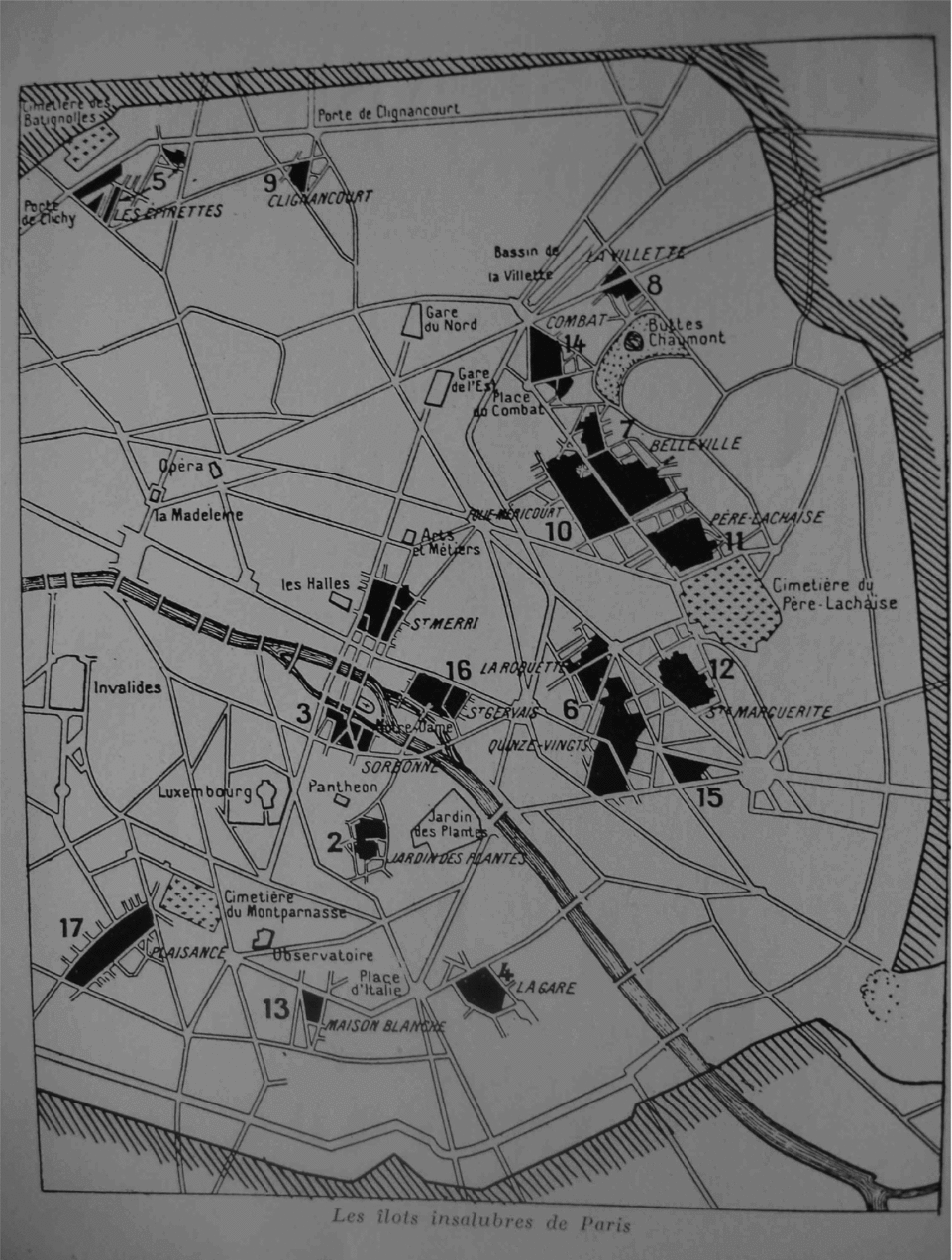


A 1921 memo from the Seine prefecture to the city councilFootnote 1 identified seventeen insanitary areas of housing (îlots insalubres)Footnote 2 in Paris with above-average mortality rates from tuberculosis. These îlots were to be razed to the ground and rebuilt. Located in the southern portion of the fourth arrondissement,Footnote 3 the sixteenth îlot on the list was apparently known as an area where the majority of its inhabitants were foreign Jews.Footnote 4 In the 1940s the secretary-general of the Seine prefecture, Guy Périer de Féral, described the area as ‘sordid, inhabited by very poor people, the majority of whom are Jewish emigrants from Eastern Europe’.Footnote 5 In October 1941 the very same prefecture and the very same Périer de Féral had begun a massive redevelopment of îlot 16.Footnote 6 This urban redevelopment was to be the only one actually implemented before the end of the war.
Areas of bad housing (Îlots insalubres) in Paris, 1921. Îlot 16 is delineated by the church of St Gervais (west) and rue St-Paul (east), by the Seine (south) and rue François Miron (north). Source: Architecture Française, March 1942.

The city council decision to evict the inhabitants of an îlot regularly described as ‘Jewish’ coincided with the start of a government policy of anti-Jewish persecution. This coincidence, if such it was, has been interpreted in two different ways. The first interpretation sees the eviction order as a racist policy disguised as an urban redevelopment plan implemented by a fundamentally anti-Semitic local administration.Footnote 7 This analysis does not explain why many Jews living in the area, though identified as such by the city services at the time of the eviction,Footnote 8 were not handed over to either the German authorities or the French police and so escaped deportation. In fact, the eviction actually assisted the escape of some of these Jews.Footnote 9
The second reading uses statistics as proof that the administration treated the Jewish inhabitants of îlot 16 in exactly the same way as their non-Jewish neighbours.Footnote 10 In 2000 the city of Paris, then under scrutinyFootnote 11, conducted a study to find whether Jewish landlords and tenants had been unfairly treated during the redevelopment process. Since the result was negative, no attempt was made to investigate the co-occurrence of racist persecution and urban redevelopment in Paris. This approach, which is chiefly quantitative, cannot penetrate further into the enigmatic motives behind the administrative action.
Thus, several questions are left unanswered. The issue of areas of bad housing had been nagging at officials since the beginning of the century; why, then, did the Seine prefecture wait until 1941 before taking action? During the Second World War, why were city officials so determined to focus exclusively on îlot 16?Footnote 12 Why did Paris then embark on a construction project on a scale not seen since the days of Baron Haussmann, in what was generally perceived to be an unfavourable situation both economically and politically?
To answer these questions, this article takes yet a third approach: it examines an ordinary town-planning decision that was made during an extraordinary period.Footnote 13 We shall see that, in 1941, local urban redevelopment policies did indeed interact with a government policy of racial persecution. Which came first, the desire of the city authorities to modernise the French capital or the desire to comply with the anti-Semitic policies implemented by the French government? Is it possible that the planning decisions affecting îlot 16 had little, if anything, to do with anti-Semitism? This question may sound provocative. However, while we do not wish in any way to minimise the acknowledged responsibility of the French government in the despoiling and murder of French Jews, we hope that our research may open new directions for the study of the Holocaust in general and the Vichy era in particular. By asking one very simple question, based on a case study, it is hoped that this article will contribute to the current upsurge in Holocaust studies concerning topics such as the relationship between spatial location and persecution (with respect to ghettoisation);Footnote 14 the links between economic interests and ideological motives;Footnote 15 and the interaction – or possibly the lack of interaction – between local and central government.Footnote 16
The article also engages with recent literature on bureaucratic networks under the Vichy regime. By October 1941, when the îlot 16 scheme began, Pétain was the head of State and his government had relocated to Vichy. Ever since the fall of France, the French State had actively participated in the implementation of a policy of racial persecution by ordering its administration to collaborate with the German authorities. The Jewish population of Paris had always been scattered across the city, although some districts held more Jews than others. In order to arrest the Jews, the government had first to locate them. In June 1941 in Paris, the police prefecture, which was a government authority, carried out a racial census: heads of Jewish households were required to register their addresses and enumerate their family members.
In the first decade of the twenty-first century researchers began to focus on the institutional and administrative dynamics of the French state's anti-Semitic policy.Footnote 17 While this is important work, it has looked only at administrative entities which were required to participate actively in the racial persecution, from organising a census of Jews to ‘Aryanising’ their goods.Footnote 18 This article departs from what we consider to be the largely tautological bias of the existing literature by focusing on the ways in which the state's anti-Semitic policy was implemented through the ordinary town-planning activities of municipal administrations.
This article is also intended as a contribution to the sociological debate on decisions and motivations relating to the Holocaust.Footnote 19 It looks at a diverse range of actors (the French government, the Seine prefecture, the Paris police, the city council, the architects in charge of the project and the inhabitants), and it is thematically wide-ranging (from various forms of corporatism to architectural modernism and to conservation of buildings judged to be of aesthetic or historical interest).Footnote 20 This enables us to take account of the possibility that while certain decisions clearly exploited the anti-Semitic measures imposed from above, the ideology behind such policies was not always anti-Semitic. In the present case, administrative organisations and interests appear far more significant for the understanding of the actual processes. Rather than ‘Vichy measures’ or measures taken ‘under’ Vichy,Footnote 21 the case of the îlot 16 redevelopment project shows it is possible to speak of policies ‘in the shadow of Vichy’. This approach can be linked to Jean-Pierre Crom's concluding remarks in his summary of the historiography of French legislation during the Second World War:
It is not entirely appropriate to contrast ‘Vichy law’ with ‘law under Vichy’. Both existed, sometimes separately, sometimes intermingled, which means that we must be cautious about any kind of generalisation. As in many other fields, the analytical scale requires continual adjustment . . . and a constant awareness of the wider context, which is usually possible, given the rich archive material available from the period.Footnote 22
The present article, situated at the interface between historiography and sociology, is fundamentally an essay in urban local history, paying particular attention to the interactions between the characteristics of a population and the events affecting its living space. We study the location of phenomena, the chronology of events and the variations among analytical scales while observing the fates of individuals at the mercy of bureaucratic decision-making. We shall scrutinise the mechanics of the operation and the close and complex interplay between changes in the lives of the inhabitants and changes in the locality where they lived. Our aim is not to decide whether or not the îlot really was a ‘Jewish quarter’.Footnote 23 Rather, proceeding on the assumption that representations are realities and vice versa,Footnote 24 we shall attempt to understand whether or not a certain ethno-religious characterisation of the îlot had an impact on the redevelopment operations under consideration here, and if so, how.
This article draws on two major types of sources corresponding to the twin approaches identified above. First, we systematically examined the eviction and expropriation files on îlot 16, now kept in the Paris city archives. Second, we searched for information on the identities and fortunes of the Jewish inhabitants in a variety of archive sources relating to the persecution of French Jews.Footnote 25 In addition, we examined the records of everyday bureaucracy,Footnote 26 from those of the Beaux-Arts administration to police crime registers.
Racial persecution and redevelopment: Intersecting chronologies
One of the main challenges historians face is to elucidate the thought processes of the actors they are studying. In the case in hand, as for so many Vichy enactments,Footnote 27 there is no clear evidence of how decisions were made – why the redevelopment scheme went ahead when it did, for example. We shall now conduct a careful, and hopefully instructive, cross-over study of the project's chronology alongside that of the relevant racial persecution policies.
First, let us recall that the elimination of slums was far from being a priority before the war. On the brink of the conflict, several people were still asking what the list of seventeen îlots was for.Footnote 28 Our îlot, the sixteenth, did not have priority even when planned building schemes around the Hôtel de Ville were given the go-ahead in 1938 with a view to the construction of a large administrative district (cité) at the heart of the capital. These schemes were dropped in May 1941.Footnote 29 In July 1941, the Paris urban planning service (Plan de Paris) and the public health and housing departments, all of which were to have a hand in the redevelopment operation, had no plans to begin work on îlot 16. The outline scheme, which we found stapled to a letter, reads ‘îlots in “utmost urgent” need of rehabilitation: 1, 2, 3, 4, possibly 11’.Footnote 30 So how did it come about that îlot 16, absent from this list, was the only one that actually had been redeveloped by the end of 1941?
The motives behind the operation may become clearer if we can determine the exact date of the decision to deal with îlot 16. We have therefore traced the entire chronology of the operation step by step from its beginning in late 1941, using interlocking scales for analysis.
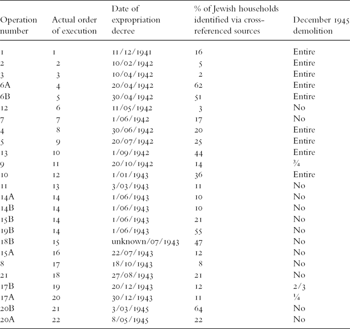
A works schedule has been conserved in the archives (Map 2).Footnote 31 Each of its twenty-one stages corresponded to an order for the expropriation of landlords and the eviction of tenants.Footnote 32 This preliminary operation began with the buildings adjoining those already owned by the city (Operations 1 and 2),Footnote 33 and continued outwards in concentric circles. Thus the operation began in a place where it was easy to secure a large landholding, significantly accelerating progress on the project. Other priorities interfered, however. Operations 1 to 5 applied to areas that included aristocratic town houses (hôtels particuliers: Aumont, Châlons-Luxembourg); as a result, actors with an interest in conserving historical monuments (the Beaux-Arts department, some intellectuals and scholars, etc.) attempted to influence the process of legislation.Footnote 34 Another ostensible purpose of the project was to open up traffic routes, particularly roads leading to bridges, such as the rue des Nonnains d’Hyères (Operations 10, 8 and 11). This preliminary stage in the operation, relating to the central area, was abandoned in 1941 but did reflect the city's plan to create an administrative cité in the heart of Paris. The idea was that the new cité, located behind the Hôtel de Ville, would include the hôtels particuliers and use them to house the secretarial services of the Beaux-Arts department. It may be that the redevelopment plan sought to reconcile conservation concerns with notions of public utility, with the additional advantage of being able to eliminate an insalubrious îlot before the end of 1941. However, when the project proper began in 1942, it departed significantly from the original ordinance. What was the reason – or reasons – behind the change that took effect some time between planning stage and implementation? (see Table 1).Footnote 35
Changes to the operations, building demolitions, and the Jewish presence
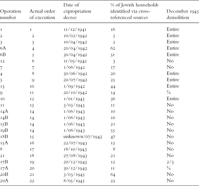
Note: The percentages were calculated as follows. First we calculated the total number of households reported to the Prefecture as ‘Jewish’ at the time of the eviction. We then added those unaccounted for by this procedure which we located from sources outside the 1900 W inventory. This total was then compared to the number of inhabited apartments according to the 1936 census data.
Source: Collection 1900 W, AP: Expropriation de la zone non aedificandi et du quartier Saint-Gervais (îlot insalubre n° 16), 1792–977 and other sources (see Note).
We attempted to determine whether there was something in common among the buildings that were dealt with either earlier or otherwise than originally planned. Among the 171 landlords (none of whom lived in the îlot) we could find no correlation between changes in priority and characteristics such as the landlord's identity (individual versus real estate company, Jew versus non-Jew, owner of one building versus owner of several buildings); the location of the property in the îlot; or the landlord's reactions to the bureaucratic intervention, which ranged from approval to dissent. The case is quite different for tenants. We have drawn up a list of the households in the îlot, with particular attention to location, time of move and administrative status (paying particular attention to which tenants were kept on file by the administration and which were not); nationality; and racial identity under Vichy law. We then compared the chronologies of the two policies: on the one hand, the eviction of the îlot's inhabitants and, on the other, the persecution of the Jews.
The twenty-one stages in the îlot 16 redevelopment operation, date unknown (probably October 1941). Source: Commission du Vieux Paris, Îlot 16, Généralités (CVP16G), carton 1.
Quickly, two operations (6A and 6B) began ahead of schedule, which put them out of order with respect to the other sub-sections of the îlot. They were those with the largest Jewish populations (50% and 62% respectively: see Map 3). Operations 1, 2 and 3 were started in accordance with the original schedule, at two-month intervals. Operation 6A was put forward to follow Operation 3, beginning only ten days later. Operation 6B began only ten days after 6A. We found several examples of this connection between the moving forward of an operation and a significant Jewish presence. Operation 13, which would involve the eviction of a large number of inhabitants, was also brought forward.Footnote 36 This section had one of the îlot's largest proportions of Jewish inhabitants: 44% of households.
Distribution of Jewish households in îlot 16 (Paris), 1941–5. Source: Paris Archives, 3067 W 898. Made by Benjamin Potet and Anne Varet-Vitu based on the 1937–8 zoning (Paris Archives).
How are we to make sense of these changes to the original timings? By comparing the chronologies of the redevelopment operations and the Jewish persecution we may find some clues to the answer. Between the start of Operations 3 (10 April 1942) and 6A (20 April 1942), the Germans set up an administrative department to organise the looting of Jewish apartments. This Dienststelle Westen (western department) was officially created on 17 April 1942, but had been in operation since March, when the first convoy of deported Jews left France. From April onwards, large numbers of Jews living in France were arrested or forced to flee, leaving or (as the Germans put it) ‘abandoning’ their accommodation.Footnote 37 Particularly affected were foreign Jews, the perceived majority of the îlot population, who had contributed to the area's pre-war characterisation as a ‘ghetto’.Footnote 38 This change to the original order by bringing forward Operation 13 coincided with a new phase in the Jewish persecution: the order of expropriation for Operation 13 was the first to be made after the Vél’ d’Hiv round-up which took place on July 16 and 17 and led to the arrest of 12,884 Jews.Footnote 39 In this instance there are strong indications that the co-occurrence of changes in the timing of the redevelopment project in the mostly ‘Jewish’ areas of the îlot, on the one hand, and on the other, the nature and intensity of the persecution of the Jews of France was not coincidental. We asked ourselves how the persecution and deportation of the Jews may have encouraged, or even incited, the expropriations and evictions in îlot 16. In answer to this question, we shall now examine the primary obstacles to renovating the îlots insalubres of Paris: obstacles that persisted until 1940 although the earliest regeneration schemes date back to the 1920s. Our research grimly highlights the way the Seine prefecture exploited the persecution of the Jews.
Redeveloping îlot 16: A chance to circumvent rehousing problems
Inter-war justifications for failing to do anything about the problem of the insanitary îlots can be summarised in two principal points, formally enunciated by the city council at the end of the First World War:
First the financial aspect, then the problem of rehousing the dispossessed . . . Was it at all possible to begin such a vast programme directly after the war, during a full-out housing crisis? It was illegal to evict tenants, and there were other moral and social obstacles as well. It was necessary to build new homes for the occupants before demolishing the old ones.Footnote 40
Despite constant amendments to the law between 1935 and 1942, all attempts to ease these constraints failed. None of the legislation bearing on the operation touches on the rehousing problem,Footnote 41 although it was evidently something that required official attention. From 1941 onwards, the Seine prefecture rehoused inhabitants on a case-by-case basis, in response to complaints from large families that there was no point in simply warning them that they were going to be turned out into the street in a few weeks’ time.
Other actors, not affected themselves by the procedure, shared these families’ concerns. In 1938, the architect Albert Laprade, future director of the îlot 16 project, stated that:
In order to house the inhabitants of the derelict buildings, we must build attractive housing on the outskirts of the city, and this time they must be genuinely intended for the workers, genuinely suited to their tastes and resources. We must build Le Corbusier's cités radieuses in the green spaces around Paris, as soon as possible. This is an absolute necessity.Footnote 42
Thus the prospect of not having to rehouse a whole category of inhabitants may have appeared as a double boon. In a neighbourhood classified as ‘Jewish’ by all the actors concerned, tenants who had been arrested or forced to flee clearly did not require re-housing. And the apartments left vacant – all over Paris – by their ‘departure’ would come in very handy when it came to re-housing evicted non-Jews.
In July 1941, then, îlot 16 was not seen as a priority. However, from August on, Seine prefecture officials actively participated in organising the detention of foreign Jews who had been arrested during the first Parisian round-ups.Footnote 43 On 27 August the occupying authorities, along with the police prefecture, the gendarmerie and the Seine prefecture, met to organise the creation of the Drancy camp. The Seine prefecture's role included supply provision, logistics and setting up the site. Hence this prefecture was directly responsible for ‘rehousing’ the arrested Jews. This means that the decision to completely clear îlot 16 was made by a department that had just realised the implications that the internment of Jews (still mostly foreign Jews at this stage) might have for housing in the capital city.
The links between the Seine prefecture's îlot 16 operation and successive stages in the persecution of the Jews were not confined to 1941, nor to the Drancy camp. We have already seen that in the spring of 1942, the escalation of evictions and the re-ordering of the îlot subsections coincided with the looting programmes organised by the Germans. This is not surprising, given that contacts between the prefecture and Dienststelle Westen were becoming more frequent at the time. The ‘abandoned’ apartments in the îlot were emptied of their furniture; the Seine prefecture stored the contents at the Crédit Municipal and made it available to the German department, with which it was in regular correspondence.Footnote 44
The persecution and deportation of the Jews was, in fact, a windfall for the Seine prefecture – and not just at the start of the operation in October 1941, or even during its acceleration in the spring of 1942. The prefecture went ahead with the operation despite opposition from all other actors, including the German authorities and the îlot's inhabitants. The German order of 22 May 1942 made it virtually impossible to implement any redevelopment scheduled to take effect after the expropriation and evictions at the îlot. The eviction operations took place anyway and as scheduled: Operations 5 and 13 are proof of this.Footnote 45 Some of the evicted tenants confronted the prefecture directly, protesting loudly and claiming their right to rehousing.Footnote 46 These protests came to a head in the summer of 1942.Footnote 47 In September the Seine prefect finally ordered a ‘general appraisal of the question’.Footnote 48
A glance through the archives of Parisian housing organisations shows that in September 1942, the plight of Jewish tenants – members of a group which was being widely and systematically persecuted – was a powerful inducement to continue with the controversial redevelopment operation. Several of the housing companies under the authority of the Seine prefecture's housing department alerted it to the fact that some city properties had been vacated by Jews without official notice and therefore could not be legally reallocated. Unsure how to proceed, the department reported to the Commissariat Général aux Questions Juives (CGQJ, general commissariat for Jewish affairs), which replied that the accommodation must be offered as soon as possible to non-Jews.Footnote 49 Certain îlot 16 families would benefit from this opportunity. At the same time, another question presented itself: could this vacant accommodation be used to rehouse Jews evicted from îlot 16? In the end, Parisians with a ‘special’ (racial) status – that is, Jews – were to be decreed ineligible for municipal housing.
The second question put by the housing department to the CGQJ in September 1942 arose from a specific rehousing case concerning one of the evicted Jews from îlot 16. In response, the commissariat ruled that the housing department must rehouse tenants who had been evicted by reason of ‘public utility operations’. Among these tenants was a Jew who had been evicted from 10 rue des Nonnains d’Hyères. He asked to be rehoused. He was a war veteran and a father and as such was entitled to this service.
Examining his request, the housing department was uncertain whether a Jewish tenant was entitled to be housed in a communal building. Some weeks previously, the Germans had demanded from the Régie Immobilière de la Ville de Paris (RIVP, Paris properties register,) a list of apartments managed by the company and inhabited by Jewish families. Seals were regularly put on the apartments whose Jewish inhabitants had been deported, or had left for the unoccupied zone or gone abroad. In most cases, all furniture was removed before the apartment was sealed.Footnote 50 So the CGQJ told the housing department that no Jewish tenants from the îlot were to be rehoused in communal buildings.
Moreover, internal correspondence from 10 April 1943 specifies that a ‘list of accommodation vacated by Jews’ had been given to a female inhabitant of the îlot who was complaining that she had nowhere to go.Footnote 51 As in Berlin, where accommodation vacated by Jews was used to rehome tenants whose homes had been demolished during the implementation of Albert Speer's project for the reshaping of the capital,Footnote 52 the arrest, deportation or escape of Parisian Jews provided the town planners with a long-awaited opportunity to deal with îlot 16.
Redeveloping îlot 16: A chance to avoid paying compensation
Jewish tenants who had vacated their apartments did not need to be rehoused, nor were they entitled to compensation. The prospect of paying substantial compensation to evicted tenants had been a major obstacle to projects for redeveloping insalubrious îlots during the 1930s. In 1936, the prospect of starting a major construction project rekindled these anxieties. Estimates on file reveal the huge potential cost of the operation, as a result of which not a single project could be implemented before the start of the war. The occupation and the ensuing widespread financial hardship tended to depress property values, and hence potential compensation.Footnote 53 This idea that falling property values would save the prefecture money on compensation were dashed, in the end, by the first conciliation commission's ruling on compensation.Footnote 54
The idea that costs might be reduced, may also have been encouraged by the systematic stripping of Jewish assets under the Vichy regime. Once again, it appears that between July 1941 (when îlot 16 was not on the list of redevelopment priorities) and October 1941 (when it was decided that all the îlot's landlords should be expropriated and all tenants evicted) the Seine prefecture was directly concerned in the despoliation of the Jews. Following the German ordinances of 20 May and 18 October 1940, the French law of 22 July 1941 confirmed that all French government departments were to be systematically Aryanised. All Jewish real estate, except private homes, would be seized. The same French law compelled administrative departments to determine the racial status of each constituent. Fifty-three merchants and shopkeepers in îlot 16 (13% of the total 397) were put under ‘provisional administration’ (administrateurs provisoires),Footnote 55 which immediately led to the devaluation of their property. It also devalued adjacent business premises.
It is now possible to explain what lay behind the planning decisions and actions of the Seine prefecture with respect to the start and pursuit of the îlot 16 redevelopment projects in October 1941. Throughout the previous summer, the prefecture had known that Jewish property was to be Aryanised. It had also been directly involved in organising the internment of foreign Jews. Hence the reputation of îlot 16 as a ‘Jewish’ quarter may have induced the prefecture to see the racial persecution as an opportunity to circumvent the main obstacles that had been preventing the expropriations and evictions in the îlot which were the necessary preliminary to acquiring an invaluable piece of real estate in the very middle of Paris. At the time the expropriation and eviction orders were published, the prefecture did not actually know the percentage of Jewish inhabitants in each section, so this information had no impact on changes to the order in which various redevelopment operations were implemented. The publication of each expropriation order was followed within a fortnight by a visit from a city architectural surveyor. The surveyors visited every lodging and were required to draw up an administrative file for each household, specifying the family's race. This file was used when awarding compensation. Evidently it was not until this had been done that the administration was able gradually to map the distributing of Jewish households throughout the îlot 16. It may be that the percentage of Jewish inhabitants affected by the first three operations (8%, 1% and 0% respectively) may have seemed so insignificant that a disappointed prefecture decided to re-order the expropriations in such a way as to give priority to areas with a higher percentages of Jews.
Even before the architectural surveyors’ visits, it had long been a matter of common but unofficial knowledge that the îlot contained ‘Jewish pockets’. In 1941, for example, Raymond Lecuyer noted, in an article published in L’Illustration, that it was an area ‘swarming with stateless persons’ where you could hear ‘echoes of bastardised Hebrew’.Footnote 56 The area he described was precisely the one affected by Operations 6A and 6B (rue des Jardins) and Operation 13 (rue du Figuier). The majority of its inhabitants were Jewish. These operations were the ones relating to the three main sections, which were brought forward in the schedule and were thus slated to begin in April 1942.
Independent of this unofficial view, once the prefecture was in possession of the architectural surveyor architects’ reports it immediately amended the operation plans so as to prioritise the more ‘Jewish’ zones. Under this new strategy, the evictions were frequently confined to certain buildings, or just parts of a street. Operation 19B covered both the rue Saint-Antoine, where few Jews lived, and the rue Charlemagne, which had a significant Jewish population. Only the inhabitants of the second street were to be evicted; those of the rue Saint-Antoine were to be spared.
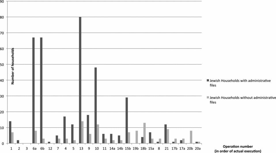
Thus the persecution of the Jews was a godsend for a department anxious to lighten the twofold financial burden of redeveloping îlot 16 and rehousing its erstwhile inhabitants. Many of the îlot's Jews had already left before the arrival of the architects, so there was no need to rehouse or compensate them. They were the forgotten people of the operation. As tenants living in the area, they should have been dealt with by the administration, but they were not. Families without any administrative files made up 21% of the 639 Jewish families that we identified as living in expropriated buildings. The copious correspondence found in the archives bears witness to the prefecture's desire not to discriminate against any of the tenants while complying with the law.Footnote 57 Of the total number of evicted households 5% ‘disappeared’ from the administrative records, saving the prefecture the cost of rehousing and/or compensating them. It may not seem like a very significant percentage,Footnote 58 but the prefecture's bureaucrats thought that it would be, and that is why they seized on it so eagerly. The actual results of the operation were less beneficial to the administration than originally expected.
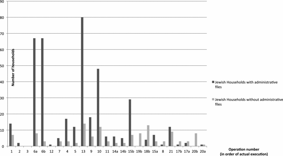
That the city administration's determination was the base of the operation may at this stage seem paradoxical. In part it derives from the Jewish reputation of îlot 16,Footnote 59 which promised to prove advantageous to the administration at a time when Jews were being persecuted. But the promise proved deceptive. For one thing, most of the inhabitants of the area were not in fact Jewish; for another, the prefecture's haste outstripped the ongoing process of racial persecution. As the operations continued, the number of Jewish households without an administrative file appears to have grown (Graph 1). It seems, then, that while the Seine prefecture's redevelopment plans may have been assisted by the persecution, this did not happen until later than the prefecture had anticipated, and then only to a lesser degree.
Jewish Households with and without administrative files per operation
Redeveloping the buildings or changing the population structure?
That the decision to expropriate the inhabitants of îlot 16 was contextually determined is confirmed by the fact that the redevelopment plan purported to use eviction as a tool to restructure the îlot's population. There was no scheme for financing the redevelopment as such,Footnote 60 and on 19 July 1944, by which time most of the evicted families had already left the îlot, Périer de Féral wrote to the Délégué Général à l’Équipement National that ‘as far as finance goes, a decision has not yet been made’Footnote 61.
As if to confirm the eviction operation was primarily opportunistic, the buildings were not renovated until long afterwards. The photo library at the Pavillon de l’Arsenal in Paris contains a series of topographic images showing buildings shored up with beams and left derelict until the 1970s. The evictions continued from 1942 onwards and the properties were left to deteriorate.Footnote 62 The registers of the Paris prefecture of police reveal an urban space given up to cupidity and greed. The only action taken by the Seine prefecture was to file complaints. Between January and March 1943 alone, Henri Drouin, a Seine prefecture engineer in charge of evacuating îlot 16, made fifteen visits to the commissariat in order to report thefts of lead from buildings for which he was responsible.Footnote 63 The haste with which the buildings had been evacuated actually caused more damage; this is all the more surprising in that the Beaux-Arts department claimed to be ensuring the preservation of buildings in the area.
Since no actual redevelopment ever took place, it soon became apparent that the evictions had been pointless. The empty apartments were to be rented out again. On 8 February 1944, after most of Paris's Jews had already been deported, an internal memo from the Seine prefecture signalled the change of course:
The Secretary-General believes that we can no longer prevent the better apartments from being rented out, despite the public utility declaration. He would like you to co-operate with the legal department to determine how we can authorise the renting of this accommodation. At first glance it appears that short-term contracts should still be valid if we plead force majeure, and we do not have to rent only to disaster victims.Footnote 64
Various archive records confirm the post-Liberation reallocation of accommodation that had been ‘emptied of tenants’ (see Map 4). By the end of the 1950s, the city had begun collecting taxes on short-term housing contracts.Footnote 65
Rental status of expropriated buildings in îlot 16, 1950. Source: Paris Archives, 3067 W 898. Made by Benjamin Potet and Anne Varet-Vitu based on the 1937–8 zoning (Paris Archives).
This reoccupation of the buildings signalled a change in the population structure, but in fact quite a number of people who had officially been evicted from the îlot had stayed in, or returned to, their old homes.Footnote 66 However, the eastern section of the îlot was totally destroyed and the population totally changed. Officially, îlot 16 had been expropriated and evacuated in order to demolish buildings that did not merit preservation, which meant most of them. And it appears that most of the buildings slated for demolition had, before the war, been inhabited largely by Jews. By 21 August 1943, the odd-numbered side of the rue des Nonnains d’Hyères had already been razed to the ground;Footnote 67the odd-numbered side of the rue des Jardins-Saint-Paul had been demolished by the following September.Footnote 68 A map made by the Seine prefecture in 1946 shows the extent of the destruction by December 1945 (see Map 5).Footnote 69 When this map is superimposed on the map of operations, it is clear that, aside from Operations 1–5 which involved demolition for ‘reasons of public utility’, the other demolition operations took place in areas with high concentrations of Jewish inhabitants (Table 1).
Demolished buildings in îlot 16 (Paris), December 1945. Source: Report on housing and redevelopment issues in Paris and its suburbs from the Seine prefect to the munical and general councils. Paris Archives, 3067 W 898. Made by Benjamin Potet and Anne Varet-Vitu based on the 1937–8 zoning (Paris Archives).
Conclusion
Our analysis has revealed a complex relationship between administrative action and racial persecution. The idea that the municipal authorities played an ‘innovative role’ in the persecution of the Jews is anything but new. Wolf Gruner drew attention to the ‘racist outlook of the municipalities’:
in fact it was at the local level that practical administrative interests had a particularly strong influence on the planning of active persecution by municipal officials.Footnote 70
However, the operation that took place in îlot 16 from October 1941 was not intended to support the persecution policy. All inhabitants, both Jews (those who had not already left) and non-Jews, were given identical treatment by the prefecture. The officials could easily have devised files for the Jewish inhabitants, but they did not. As it turned out, 57% of the 415 Jewish families who were evicted by the prefecture (and thereby formally and openly identified as Jewish) escaped deportation. This indicates that if the îlot 16 development operations were connected with the anti-Semitic policies of the French state, the connection was only opportunistic. Here, our conclusions converge with those of several other recent research projects that emphasise that the way various actors approached the ‘Jewish problem’ was dictated by their own interestsFootnote 71 rather than by ideology or opinion. However, and more surprisingly, if the Seine prefecture's redevelopment projects were not inspired by state anti-Semitism, they did help to normalise and trivialise it. Tal Bruttmann came to a similar conclusion in his study of Aryanisation in the Isère region of France.Footnote 72 Our article supplements these previous studies. It demonstrates that identical processes could take place in connection with policies that, strictly speaking, had nothing to do with the persecution.
It is unwise to assume direct causal links; nor should we concentrate on purely structural effects to the neglect of individual behaviour.Footnote 73 Rather we must reveal the mechanisms that underlay the decisions made at this particular moment in the history of the French state, particularly the chronology of that state's evolving policies. It then becomes strikingly obvious that ‘by re-situating the despoliation within the framework of medium-term economic and social history we can expose a rationale that would otherwise remain opaque. As is often the case, one policy made it possible to carry through another’.Footnote 74
In taking this approach and in drawing our conclusions, we are very aware that the results are specific to a particular situation and are therefore, unavoidably, fragmentary results which take their true meaning in a conception of social sciences as cumulative. We need to compare other contexts, including some that are right outside the domain of racial persecution in Paris in the early 1940s. The Vichy period represented a time of opportunities for reforms in sectors that the Third Republic had neglected,Footnote 75 and, as we have shown, this more general context helps to explain the redevelopment process in îlot 16. Moreover, the exodus from Paris affected all social groups and all areas of the city.Footnote 76 This massive exodus may have also played a role in the administration's decision to address the issue of insalubrious îlots in October 1941. Paris was not the only city so affected: Joseph Dawidowicz, a resident of Lens before the war, returned in 1944 to find that his home was occupied by a local government department, which had acquired the building from the temporary manager in control of the property.Footnote 77 Different studies are perforce on different scales, but this does not prevent dialogue between them.
Overall, this article is the first step in a larger study of the fate of the Jews living in a certain part of Paris. We believe that the approach and scale of our study are unprecedentedFootnote 78 and we hope that, in conjunction with studies of the fortunes of certain individuals, it will contribute to an understanding of the processes which determined both persecution and survival. From this point of view, the interface between sociology and history turns out to be a particularly fruitful area of study.