INTRODUCTION
From 1980 to 1983, the Instituto Nacional de Antropología e Historia (INAH) conducted systematic salvage excavations within the Early Postclassic city of Tula, Hidalgo (Abascal Reference Abascal Macías1981, Reference Abascal Macías1982), believed to be Tollan Xicocotitlan of Aztec legend. These investigations were conducted in advance of two large-scale construction projects: (1) a railway for a high-speed “bullet” train that would traverse the site, and (2) a large tourism complex that included a museum, botanical park, pathways, and public parking. The extent and magnitude of these simultaneous projects would negatively impact a large part of the ancient city, and therefore required a coordinated program of investigation on a much larger scale than typical salvage projects. The project that was initiated, referred to as the Proyecto Tula ’80, adopted a multifaceted investigation strategy. On the one hand, the linear character of the proposed route for the railroad provided an opportunity to conduct exploratory excavations in the form of a transect sample of the ancient city. At the same time, the proposed tourism complex provided an opportunity to conduct more intensive investigation within a large, continuous area. As will be seen, the combination of limited exploratory excavation on a wide scale and more extensive exposure in a few localities proved to be an effective strategy. In addition, limited excavations were conducted at two localities at Tula Grande: Building J, also known as Anexo C, which Acosta had briefly explored, and Las Plazas on the western edge of Tula Grande.
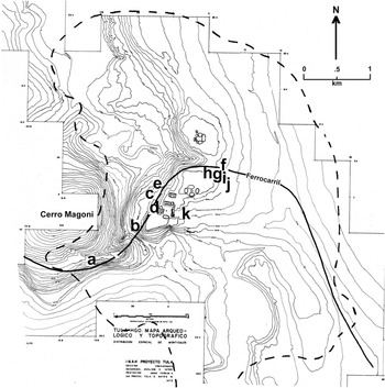
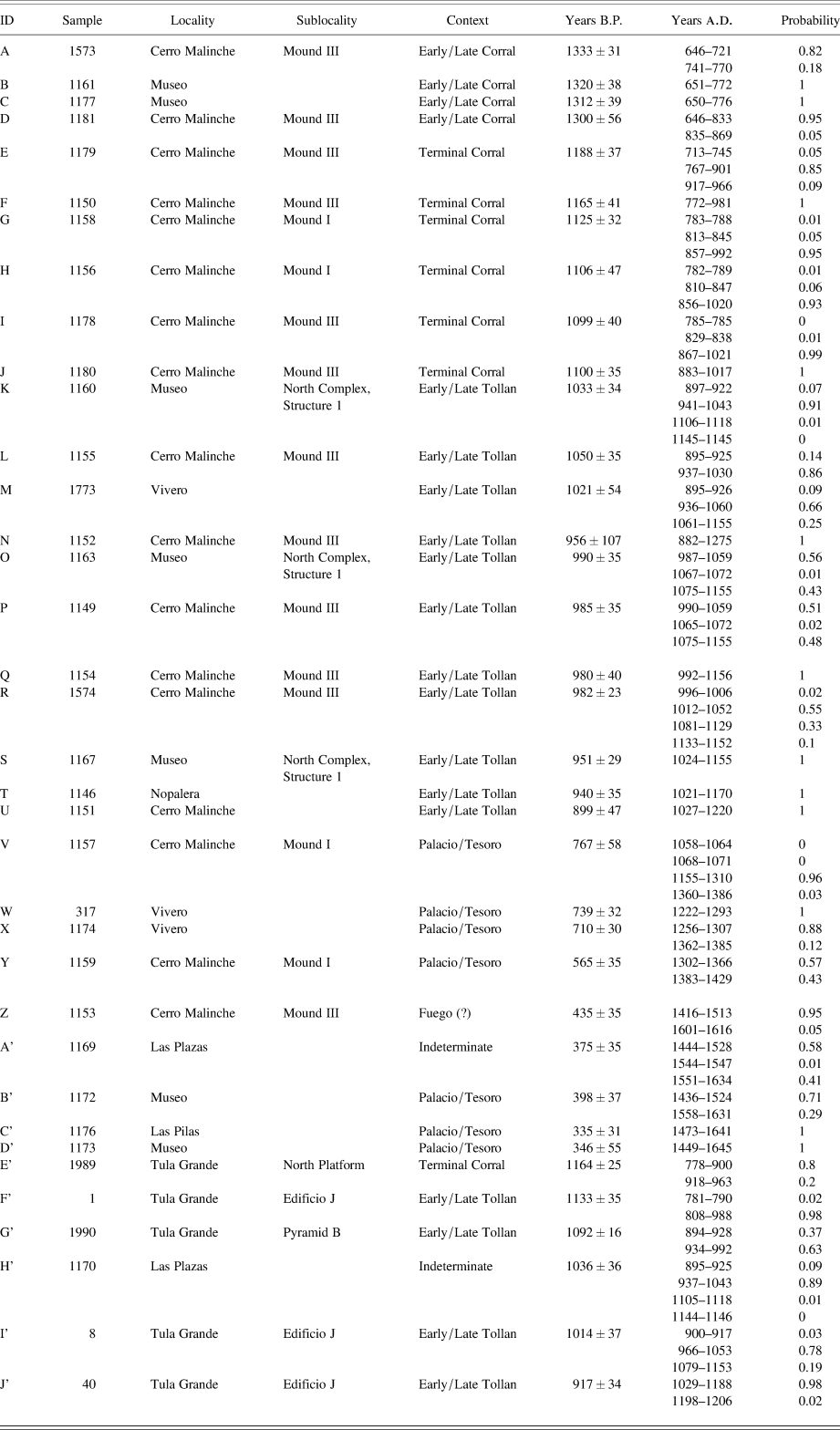
In total, 11 separate investigations were conducted at 11 different localities (Figures 1a–1k). Preliminary exploratory excavations encountered structural remains in all 11 localities, leading to more extensive exposure in nine of these. All excavations yielded ceramic, lithic, and other artifacts from controlled contexts, and the more extensive exposures provided detailed information on domestic and non-domestic architecture. Approximately 250 burials were also recovered, which have provided considerable additional information concerning funerary practices during various periods in the life of the city, as well as biological data. Considerable faunal remains were recovered, including those of canids, avians, ovines, and mollusks (Gómez Serafín et al. Reference Serafín, Susana, Sansores and Fernández Dávila1994; Paredes and Valadez Reference Paredes and Valadez1988a, Reference Paredes and Valadez1988b; Valadez and Paredes Reference Valadez and Paredes1993, Valadez et al. Reference Valadez, Paredes and Gómez1999). Finally, some 36 radiocarbon dates were obtained that form an almost continuous sequence from the Epiclassic to the early Colonial period (Table 1).
Map of Tula (Yadeun Reference Yadeun and Matos Moctezuma1974), showing the projected limits of the Early Postclassic Tollan phase city (dashed line) and the localities (A–J) discussed in the text.

Calibrated radiocarbon dates obtained by Proyecto Tula ’80, arranged by median probability date. B.P., before present.

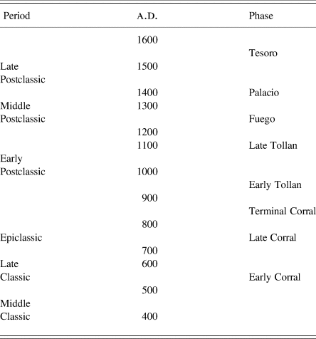
Although preliminary results of some of these investigations have been published, the present study incorporates the results of more recent studies conducted independently of those. In 1983, Paredes Gudiño was given the opportunity to undertake a formal study and classification of many, previously unstudied materials (Paredes Reference Paredes1983), and this forms a major component of the new information presented below. The present study provides the opportunity to integrate past and present knowledge gained from these investigations in a holistic manner, using a diachronic perspective provided by the chronometric dating. Accordingly, we shall proceed in chronological fashion, summarizing the results by time period using the revised chronology proposed by Healan et al. (Reference Healan, H. Cobean and T. Bowsher2021) and presented in Tables 2 and 3.
Revised chronology for Tula and the Tula region (after Healan et al. Reference Healan, H. Cobean and T. Bowsher2021).

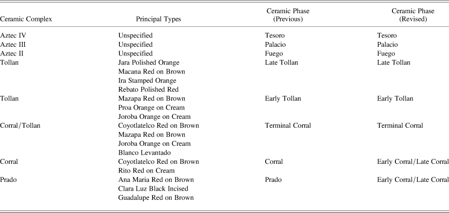
Ceramic phases, corresponding ceramic complexes, and principal types in the Tula ceramic chronology (Cobean Reference Cobean1990).

EPICLASSIC PERIOD (EARLY CORRAL AND LATE CORRAL PHASES)
The transition from the Classic to Epiclassic period in central Mexico is marked by two events: the demise of Teotihuacan and the appearance of a distinctive ceramic complex called Coyotlatelco. It was during this period that the initial settlement of Tula took place, whose location at the juncture of several routes of transportation made it a place of importance. Indeed, preliminary results of DNA analyses of burials (Paredes Gudiño Reference Paredes2020) indicate that the city may have been multi-ethnic in composition from the beginning.
The demise of Teotihuacan impacted all of Mesoamerica and was the defining event for the end of the Classic period in Western Mesoamerica (Diehl and Berlo Reference Diehl and Berlo1989; Jiménez Moreno Reference Jiménez Moreno1959; Webb Reference Webb and Browman1978). Until relatively recently, the fall of Teotihuacan was dated to around a.d. 750, but in the 1990s, several investigators proposed pushing this date back at least a century (Cowgill Reference Cowgill1996; Rattray Reference Rattray, Mastache, Parsons, Santley and Serra Puche1996, Reference Rattray2001). There now appears to be consensus that the fall of Teotihuacan occurred during the first part of the seventh century a.d., at which time there appeared several new urban centers and cultural traditions in central Mexico (Nalda Reference Nalda1998), among them Xochicalco, Morelos, Cantona, Puebla, and Tula.
Coyotlatelco was first identified in excavations near Atzcapotzalco in the Basin of Mexico (Tozzer Reference Tozzer1921), and its Epiclassic dating was based mainly on its presence in post-Metepec contexts at Teotihuacan (e.g., Armillas Reference Armillas1950:53–56). Rattray (Reference Rattray1966) produced the first definitive study of the complex, and more recent comprehensive studies include those by Cobean (Reference Cobean1990), Nichols and McCullough (Reference Nichols, McCullough and Sanders1986), Paredes (Reference Paredes1998a, Reference Paredes and Valadez1998b, Reference Paredes and García2004, Reference Paredes and Manzanilla2005a, Reference Paredes2005c), and Solar Valverde (Reference Solar Valverde2006).
Coyotlatelco ceramics were first identified at Tula by Acosta and Moedano in exploratory excavations at Tula Grande and Tula Chico, respectively (Acosta Reference Acosta1945). Systematic surface survey of Tula conducted by INAH (Yadeun Reference Yadeun Angulo1975) and by the University of Missouri (Healan and Stoutamire Reference Healan, Stoutamire and Healan1989) found that surface evidence of Coyotlatelco ceramics was concentrated in the area around Tula Chico, leading investigators of both projects to propose that Tula Chico had served as the monumental center for the earliest (Epiclassic) settlement at Tula, estimated to cover an area of approximately 3–6 square kilometers (Cobean Reference Cobean, Cobean, Healan, de Escobar and Crespo1982; Mastache and Crespo Reference Mastache, Crespo, Cobean, Healan, de Escobar and Crespo1982:23; Yadeun Reference Yadeun Angulo1975:22). Ceramics obtained from exploratory excavations at Tula Chico by INAH and the University of Missouri played a major role in Cobean's (Reference Cobean1990) formulation of the Prado and Corral ceramic complexes of the Early and Late Corral phases (Table 3).
The Proyecto Tula ’80 investigations have considerably expanded our knowledge of the extent and nature of Tula's Epiclassic period settlement (Paredes Reference Paredes2005b, Reference Paredes and Daneels2009), indicating that it was probably larger and more complex than previously thought. Both Early Corral and Late Corral phase ceramics were recovered in excavation in five localities (Figures 1a, 1f, 1g, 1i, and 1j), and associated structures were encountered in two of these (Figures 1a and 1g). In the course of these excavations, over 150 complete vessels were recovered.
Museo Locality
The most comprehensive information on the Epiclassic settlement was obtained from investigations in the Museo locality (Figure 1g), involving a program of exploratory excavations at the site of the construction of the Museo Jorge Acosta. Despite the limited exposure, exploratory excavation encountered portions of Epiclassic period structures containing rooms, corridors, and patios quite similar in form to residential compounds characteristic of the early Postclassic Tollan phase. Associated features included altars, drainage systems, and masonry columns likewise characteristic of Tollan phase residential architecture (Paredes Reference Paredes1998b). These Epiclassic structures, the first ever exposed at Tula, utilized many of the same architectural features, including stucco-covered floors and walls of both adobe and stone and the use of the distinctive tabular stone facing, commonly associated with Tollan phase civic and ceremonial structures at Tula Grande and elsewhere.
A large number of burials associated with the Epiclassic occupation were encountered in excavation. Gómez Serafín et al. (Reference Serafín, Susana, Sansores and Fernández Dávila1994:53–76) provide detailed information on 24 of the burials, including three (Entierros 13, 1, and 60) that contained two, three, and seven individuals, respectively. Most of the individuals in the multiple burials were secondary interments, as were eight of the single burials. Many contained ceramic vessels and/or other offerings, which in two cases included skulls and bones of other individuals that appear to have been accompanying grave goods rather than additional interments.
One of the most notable finds was the discovery of seven burials involving one or more canids. Most of these had been placed in their own pits, distinct from those of the human burials, but were often situated alongside the latter. The canid remains included some 27 individuals, representing three distinct races (Valadez et al. Reference Valadez, Paredes and Gómez1999), including the famous Xoloizcuintli native to West Mexico. Two other canid burials were encountered in Epiclassic contexts in the Cerro Malinche and Tunel Falso localities (Figures 1a and 1f), and another in recent excavations at Tula Chico (Cobean et al. Reference Cobean, Healan and Suárez2021).
Another find of considerable interest was a human burial with remains of three Psittaciformes, specifically two specimens of Ara militaris (macaw) and one of Amazonia finschi (parrot), which was encountered beneath a stucco floor (Valadez and Paredes Reference Valadez and Paredes1990). The three are only partial specimens, of which the most complete lacked the skull. Both are colorful species, native to western Mexico and Central America, and we assume they were valued for their plumage. A carved stone panel, bearing the likeness of a very similar avian, possibly a macaw, was encountered in excavations at Tula Chico (Cobean et al. Reference Cobean, Healan and Suárez2021:Figure 5g). Many of the burials had worked and unworked shell objects, including both Pacific and Gulf Coast species.
Interestingly, 13 of the Epiclassic period burials recovered during the Proyecto Tula ’80, including eight from the Museo locality and three from Cerro Malinche, exhibited auditory exostoses (Paredes Reference Paredes and Manzanilla2005a), an inner ear disorder commonly attributed to prolonged exposure to cold and water, although there may be other contributing factors (Godde Reference Godde2010). A recent study identified the disorder in 11 individuals in an osteological sample of 124 individuals from a Late Postclassic village along the shore of Lake Xochimilco in the Basin of Mexico (Medrano Enríquez Reference Medrano Enríquez2001). All but one of these 11 individuals were adult males, and the other, a subadult with masculine features, suggesting an association with a gender-specific activity. All of the 13 Tula individuals were adults, but included both males (n = 10) and females (n = 3) (Paredes et al. Reference Paredes, Flores and Valentín1988).
Two radiocarbon samples were recovered, one associated with one of the burials, and both produced dates with nearly identical age ranges, approximately a.d. 650–775 (Table 1:B, C).
Cerro Malinche Locality
Remains of Epiclassic period occupation were also encountered in excavations atop Cerro Malinche at the confluence of the Tula and Rosas rivers (Figure 1a). The investigations focused on three large mounds, designated I–III, excavation of which revealed that Mounds I and III were composite features composed of the remains of a series of superposed residential structures spanning the Terminal Corral, Early Tollan, and Late Tollan phases, as described below. In Mound III, remains of Corral phase structures were encountered in two exploratory excavations beneath the earliest (Terminal Corral phase) of the superposed structures. One structure contained a stucco floor and stone wall atop a low platform constructed over tepetate, the local caliche whose surface contained two trash-filled pits with Early Corral and Late Corral sherds. The other structure was likewise constructed over tepetate, which contained a multiple burial pit containing two adults and two children, plus several Coyotlatelco vessels.
Other excavations along the southern flank of Mound III encountered additional evidence of Epiclassic occupation, including a compacted earth surface and adobe wall associated with a burial likewise containing Coyotlatelco ceramics. Radiocarbon samples associated with the burial yielded two dates whose probability ranges fell mainly in the seventh and eighth centuries a.d. (Table 1:A, D).
Excavations conducted on Mound I at the east end of Cerro Malinche likewise encountered a series of superposed residential structures, beneath which limited exploratory excavation encountered a burial containing five individuals and a Coyotlatelco vessel, which was partially intruded into the stucco floor of an underlying structure left unexcavated. A nearby excavation encountered a burial of a single canid similar to those from the Museo locality.
In summary, despite the limited degree of exposure, both the Museo and the Cerro Malinche excavations produced evidence of Epiclassic period occupation, including the first exposure of Epiclassic domestic structures, which show continuity with residential architecture of the later Tollan phase. The presence of a Corral phase occupation atop Cerro Malinche suggests that Tula's Corral phase settlement was larger than previously thought. Where Mounds I and III are located offers a grand view of Tula Chico and the surrounding river valleys and would have been scenic as well as strategic. In fact, this is part of a larger pattern in the Epiclassic period of site location atop hills and elevated areas that includes La Mesa and neighboring sites at the eastern end of the Tula valley (Healan et al. Reference Healan, H. Cobean and T. Bowsher2021; Mastache et al. Reference Mastache, Cobean and Healan2002:60–77), as well as Tula Chico itself and Cerro Magoni, located immediately north of Cerro Malinche (Figure 1).
EPICLASSIC/EARLY POSTCLASSIC (TERMINAL CORRAL AND EARLY TOLLAN PHASES)
Cerro Malinche Locality
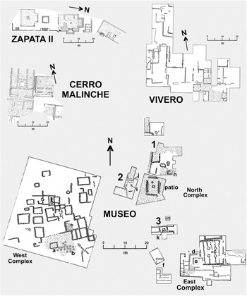
Excavations at Cerro Malinche also encountered remains associated with Terminal Corral and/or Early Tollan phase ceramics in four locations. As noted above, excavation revealed that Mound III consisted of a series of large, superposed residential structures of seemingly high status, the earliest of which (Figure 2) contained a radiocarbon sample whose age range fell mainly within around a.d. 770–900, thus spanning the Terminal Corral and Early Tollan phases (Table 1:E). The multiple burial from the Epiclassic period described above was situated directly beneath the impluvium of the interior patio in the northwest portion of this structure, suggesting settlement continuity between the inhabitants of the Terminal Corral residence and the previously buried individuals. Two radiocarbon dates were obtained for samples recovered from a partially exposed structure near the southeastern limits of the excavation, which yielded somewhat later dates, whose ranges fell principally between around a.d. 870 and 1020 (Table 1:I, J).
Plans of structures encountered in various localities. Plans by Healan and Paredes Gudiño.

A similar situation was encountered in Mound I, where the earliest of a series of large, superposed structures of seemingly high status was associated with Mazapa ceramics characteristic of the Terminal Corral and Early Tollan phases (Table 3), and two radiocarbon samples yielded very similar dates, principally in the range a.d. 870–1020 (Table 1:G, H).
Exploratory excavations in an area east of Mound III encountered five burials with Terminal Corral complex ceramics (Table 3), near to which a partially exposed structure was encountered that contained a multiple burial with a radiocarbon sample from around a.d. 770–980 (Table 1:F).
Exploratory excavation east of Mound I encountered a structure of basalt boulders arranged into a nearly complete circle, some 2.2 meters in diameter, which contained four secondary burials, three of which were partial and could have been offerings. The complete individual was associated with several grave goods, including a tripodal bowl with negative decoration of geometric designs and a transverse cut shell motif, a Mazapa vessel, a whole shell, and a fragment of alabaster. The complete individual exhibited auditory exostoses.
The identification of a Terminal Corral phase occupation at Cerro Malinche provides support for the veracity of this transitional phase that had previously been encountered in only a few contexts at Tula (Healan Reference Healan2012:60). The transitional character of its ceramic assemblage is seen in other aspects of material culture, including the construction of grand residences exhibiting the same architectural features that become common in subsequent phases.
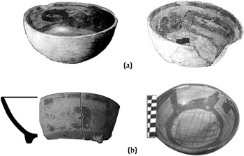
Notably, some of the ceramics recovered from the Terminal Corral phase burials comprise a distinct red on buff subcomplex characterized by very large geometric motifs, including the xicalcoliuhui or stepped fret motif (Figure 3a; Paredes Reference Paredes1998b, Reference Paredes and Barba2000, Reference Paredes and Manzanilla2005a). Very similar vessels have been found in the Sayula region of Jalisco, and also in the Classic period Ramon ceramic complex (Figure 3b) of the eastern Bajío (Hernández Reference Hernández2001). This subcomplex has so far only been found at Cerro Malinche, in Terminal Corral phase contexts.
Examples of bowls with “large format” designs. (a) Terminal Corral phase, Cerro Malinche; (b) Ramón complex, eastern Bajío. Photographs by Healan and Paredes Gudiño.

EARLY POSTCLASSIC PERIOD (EARLY TOLLAN AND LATE TOLLAN PHASES)
It is during the Early Postclassic period that Tula became a major political entity in western Mesoamerica and grew to its maximum size. Not surprisingly, Tollan complex ceramics (Table 3) were encountered in all of the localities explored during the Proyecto Tula ’80, and were associated with architectural remains in six localities (Figures 1a–1c, 1g, 1i, and 1j). Extensive excavation conducted in five localities has considerably enhanced our knowledge of settlement within the city during its apogee.
Cerro Malinche Locality
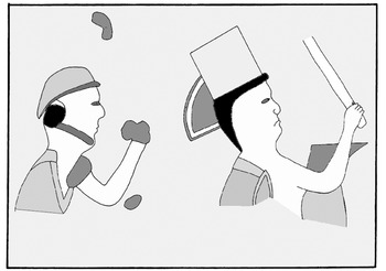
It was noted above that excavations of both Mounds I and III encountered a superposed series of large residential structures of seemingly high status, the earliest dating to the Terminal Corral phase and continuing into the succeeding Tollan phase. In both mounds, four distinct structures were identified, each a whole new undertaking rather than renovation of the existing structure. The best preserved structures exhibited numerous features in common, including substructure platforms faced with worked stone slabs, a gallery or portico along the front, and interior walls and floors faced with stucco, all of which are also characteristic features of their Terminal Corral phase predecessors, like that seen in Figure 2. Some common features of monumental architecture at Tula Grande are also present, including wide adobe walls covered with painted or unpainted plaster, tlecuiles, or stone lined hearths, recessed into the floor, and drainage systems employing stone troughs and in some cases ceramic tubes like those encountered in other residential structures at Tula (Healan Reference Healan and Healan1989). Interior walls commonly had a sill running along the bottom, and some doorways contained the scars of framing posts. Some of the painted walls appear to have been murals. One wall bore traces of three vertical stripes of blue, red, and yellow, and in the same room a large, loose stucco fragment was found that bore representations of two human figures wearing head gear and wielding weaponry or other objects (Figure 4). Two structures contained small circular features of stone measuring c. 1 m in diameter whose interior was faced with stucco. Both were connected to one or two stone troughs whose interior surface was likewise covered with stucco (Paredes Reference Paredes1990:Foto 12a). They appear too small to have been temascales (sweat baths), but appear to have been designed to hold water.
Fragment of a polychrome stucco mural depicting two individuals wearing head gear and brandishing objects (Paredes Reference Paredes1990:Figure 13).

Two burials of considerable interest were associated with these structures. In Mound 3, a burial of a young adult male was encountered that contained 59 grave goods, among them Huastec style ceramics and numerous projectile points. The historian Patrick Johannson (Reference Johannsson2012:67–84, 111) notes a long history of interaction between central Mexico and the Huasteca, and the Anales de Cuauhtitlan specifically mention arrow sacrifice of Huastec prisoners at Tollan.
In the uppermost structure in Mound I, excavation encountered postcranial remains of two ovines inside a large olla recessed into the floor and capped with a basalt boulder (Paredes and Valadez Reference Paredes and Valadez1988b:174, Figure 2). The remains were identified as female Bighorn Sheep (Ovis canadiensis) native to Baja California and other parts of northern Mexico. The remains included small beads of bone, alabaster, pink and white coral, mother of pearl, unidentified violet material, and green stone.
It is notable that throughout the Mound I excavations, remains of numerous animal species were recovered, suggesting the consumption and/or keeping of species both native and non‑native to the Tula region (Paredes and Valadez Reference Paredes and Valadez1988a, Reference Paredes and Valadez1988b; Paredes Reference Paredes1990; Valadez and Paredes Reference Valadez and Paredes1990).
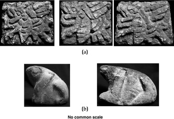
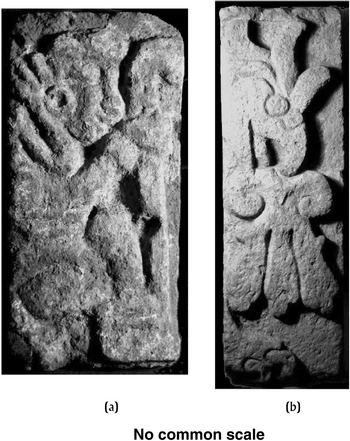
In addition to utilitarian wares, ceramics from the Tollan phase occupation at Cerro Maliche included various imported polychromes, including cloisonne and a stucco‑covered polychrome bowl painted inside and out in blue, red, and yellow designs and outlined in black, now on display in the Sala Epiclasica at the Museo Nacional de Antropología, Mexico City. Limited exploratory excavations of a third mound (Mound II) exposed a small structure atop a pyramidal platform that may represent a barrio level temple similar to one encountered elsewhere in the city (Stocker and Healan Reference Stocker, Healan and Healan1989). Associated materials included several loose pieces of stone sculpture, including a representation of a squatting individual wearing a loincloth and long hair tied in the back. Two in‑the‑round sculptures of frogs were recovered, each initially painted red, covered with stucco, and then painted greenish blue (Figure 5b). In addition, three carved stone panels were recovered bearing images of what have been variously interpreted as bees (Paredes Reference Paredes1998a) and butterflies (Jimenez García Reference Jiménez García1998:321), although the body appears bee‑like in form (Figure 5a).
Carved stone sculpture from Cerro Malinche. (a) Carved images believed to represent bees; (b) full round plaster-covered and painted representations of frogs. Photographs by Elizabeth Jiménez García.

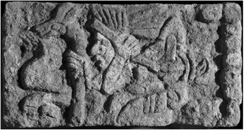
Carved stone panel from ash deposit beneath Structure 2-sub B, Museo locality, depicting an individual with a load and a zoomorphic staff, possibly Yacatecuhtli, god of merchants. Photograph by Bruce Love.

There seems little doubt that the Tollan phase occupation at Cerro Malinche represents a barrio of persons of extremely high status. Its location affords a commanding view of Tula Grande and the surrounding valley and would have been an attractive, strategic, and privileged location. In addition to the four from Terminal Corral contexts described above, six additional radiocarbon dates were obtained from excavations of Mound III for samples from contexts associated with Tollan complex ceramics that collectively span the Early and Late Tollan phases (Table 1:L, N, P, Q, R, and U).
Zapata II Locality
One of the most intriguing explorations of the Proyecto Tula ’80 took place in the Zapata II locality on the west bank of the Tula River, immediately southwest of Tula Grande (Figure 1b). Excavation exposed a linear arrangement of structures that followed the curve of the river, which formed part of what appears to be a civic-ceremonial complex (Figure 2) that included a temple, an altar, and two large buildings, each containing two or more interior rooms with flanking benches (Paredes Reference Paredes and Barba1998c). Although initially called “palaces,” neither building seems suited for a residential function, and they appear to have had a more public function. All of the structures had stucco-covered walls and floors, and exhibited decorative facades of tabular stone facing.
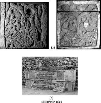
Associated remains included numerous carved stone tablets, some in situ, with extraordinary iconographic content. This includes two tablets on the face of the alfardas, or ramp-like structures, flanking a stairway, with images of reclining individuals from each of whose chests rises a tree-like plant bearing fruit or other objects (Figure 7). A strikingly similar representation of what appears to a prickly pear cactus (Opuntia sp.) emerging from the abdomen or groin of an individual appears in the Aztec-period Códice Azcatitlan (Reference Códice1949). Other tablets bore representations of an individual believed to be the deity the Aztecs called Yacatecuhtli, god of merchants, and eagles devouring bleeding hearts (Figure 8), the latter strikingly similar to the famous panels on Pyramid B, Tula Grande. Considering its monumental character and rich iconographic content, Zapata II was clearly a center of importance.
(a) Carved stone panels flanking a stairway, Zapata II locality; photograph by Elizabeth Jiménez García. (b) Panels in situ; photograph by Carlos Henández Reyes.

Carved stone panels from the Zapata II locality. (a) Individual with staff, possibly Yacatecuhli, god of merchants; (b) eagle devouring a bleeding heart. Photographs by Elizabeth Jiménez García.

La Nopalera and Vivero Localities
The La Nopalera locality was situated near the museum parking lot (Figure 1i), where excavations encountered remains of one or more residential structures. Unfortunately, no maps of these remains are available, but excavation notes indicate a configuration of rooms with stucco-covered floors and walls, arranged around a central patio with an impluvium (Paredes Reference Paredes1990:99–100), reminiscent of the high-status residences in the Malinche locality. A radiocarbon date obtained for an associated carbon sample was in the range a.d. 1020–1170 (Table 1:T).
The Vivero locality was a low mound situated southeast of La Nopalera (Figure 1j), where excavation exposed portions of three contiguous multi-room structures that appear to be residential compounds associated with Tollan complex ceramics (Figure 2). None of the three was sufficiently exposed to determine their overall size and configuration, but some portions exhibit a spaciousness and architectural quality like those seen in the high-status residences in the Malinche locality. Like the nearby Museo locality, there is evidence of a substantial reoccupation during the Aztec period Palacio phase, as described below.
Three radiocarbon dates were obtained from the Vivero locality excavations, one for a carbon sample associated with the Tollan phase occupation, with a probability range from the tenth well into the twelfth century a.d. (Table 1:M). The other two samples were associated with the Aztec period occupation and are presented below.
Museo Locality
Numerous Tollan phase structural remains were encountered in a series of discontinuous excavations conducted in three contiguous areas corresponding to the walkways and layout of the proposed museum buildings. Owing to the museum construction that was going on at the same time, the excavations were limited in scale but nevertheless exposed portions of three contiguous structural complexes, designated the North, East, and West complexes (Figure 2). All three appear to have been parts of house compounds, a common form of residential compound in Tula (Healan Reference Healan2012; Paredes Reference Paredes1990).
Although the most extensively exposed, the West complex was poorly preserved owing to its proximity to the surface. The extant remains are a portion of a residential compound, presumably a house compound, that included a central patio and altar (Figure 2a) and a multiroom structure on its north side. The latter includes what appear to be a number of individual single-room structures, but are more likely remnants of individual rooms within the larger building. Structural remains on the flanks of the patio probably represent structures on its east and west sides. Traces of stucco were encountered on the patio floor and in several of the rooms on the north side. The compound was reoccupied during the Palacio phase and became the site of sustained burial activity (Figure 2b), as described further below.
The East complex is an ill-defined entity whose principal feature is a large, nearly square building with four columns surrounding a centrally-located subfloor stone slab-lined receptacle, or tlecuil (Figure 2c), a configuration commonly seen in the open patio or atrium of high status residences and civic-ceremonial architecture in other parts of ancient Tula. The columns were constructed of stone with mud mortar and faced with the same small tabular stone facing typical of columns and pillars in other buildings at Tula, including those encountered in the Corral phase structures in the Museo locality that were described in the preceding section. Limited subfloor excavation encountered a drainage system like those encountered beneath other structures at Tula, consisting of a trough lined and capped with stone slabs. An unusual and complicating feature of the building are numerous insubstantial walls between the exterior walls and column bases that partition what was otherwise a single, spacious hall into eight or more smaller rooms. These enigmatic and crudely built features are so out of character with the other aspects of the building that we believe they were later modifications, possibly dating from the Aztec period given evidence of considerable Palacio phase activity elsewhere in the Museo locality. Unfortunately, no ceramic data are available for the East Complex that might determine this.
The remainder of the exposed portion of the East Complex is a series of ill-defined structures that include a partially-exposed rectangular platform accessed by steps on at least the north side (Figure 2d). The platform had been constructed over a smaller, nearly square platform (Figure 2e) faced with small tabular stone (Gómez Serafiín et al. Reference Serafín, Susana, Sansores and Fernández Dávila1994:Foto 23, Figure 45), a common form and construction for structures interpreted as altars. Two secondary burials of children designated Burials 6 and 7 were encountered behind the stairs in the space between the two structures.
Immediately to the west, exploratory excavation exposed part of a small temple platform (Figure 2f) and a portion of a two-tiered stairway on its north side. Excavation of the main body exposed a series of walls of unknown context, possibly part of a superstructure or perhaps earlier stages of the platform itself. As described and depicted by Hernández et al. (Reference Hernández, Healan and Beekman2019:Figure 2), it appears similar to small temple platforms encountered in other excavations, including Cerro Malinche as described above, believed to represent barrio level religious structures.
The North Complex: Altar, Cist Burial, and Other Unusual Finds
Despite its extremely limited nature, excavation in the North Complex encountered a number of unusual finds that suggest its occupants were high status individuals, possibly artisans, with access to luxury items. The core of the complex is a central patio flanked by platforms on all four sides, giving it a “sunken” appearance. Portions of three structures, designated 1–3 in Figure 2, were encountered in excavations on the north, south and west sides of the patio, and are presumed to be portions of residential structures atop the flanking platforms. Unfortunately, these structures could receive only limited exploratory excavation due to ongoing construction activity.
The overall architectural quality of the central patio and its components suggests it was part of a house compound of relatively high status. Currently visible at the entrance to the Museo Jorge Acosta, the patio was accessed by well-constructed stairs on its east and west sides that connected to a surrounding passageway that led to the flanking structures. Despite its relatively small size, the patio contained a central altar constructed of a single talud and tablero and an adjacent tlecuil. The patio, stairs, and passageway were all floored with stucco, and the patio walls and altar faced with tabular stone.
On the north side, Structure 1, the most extensively explored, was spacious, well built, and floored with stucco. The room facing the patio was quite large and contained two rectangular structures described as altars (Figures 2g and 2h), both of which were larger than and different in construction from that of the central patio. Both were simple rectangular enclosures constructed of unworked stone, one of which was constructed entirely of basalt. No other information is available regarding Structure 1 or its contents. Three radiocarbon samples recovered from Structure 1 yielded dates whose probability ranges collectively spanned the Early and Late Tollan phases (Table 3:K, O, S).
Excavation on the west side of the patio uncovered a portion of Structure 2 consisting of a spacious room floored with stucco and containing a subfloor tlecuil (Gómez Serafiín et al. Reference Serafín, Susana, Sansores and Fernández Dávila1994:Figure 37, upper; not shown in Figure 2). Excavation continued beneath the floor and encountered wall remnants and a stucco floor of an earlier structure that lay c. 40 cm below Structure 2. This earlier structure, designated Structure 2-sub A, contained two prominent features, a small rectangular altar and a stone-lined subfloor cist (Figures 2i and 2j), the latter containing an extended human burial with an array of highly unusual grave goods, as recently reported by Hernández et al. (Reference Hernández, Healan and Beekman2019) and described below.
Like the altar in the central patio, the Structure 2-sub A altar had the form of a single talud faced with courses of tabular stone and a tablero constructed of stone and mud mortar decorated with a succession of rectangular or greca-like elements carved in relief and painted in alternating colors of red and white (Gómez Serafiín et al. Reference Serafín, Susana, Sansores and Fernández Dávila1994:Foto 20, Figure 39; Hernández et al. Reference Hernández, Healan and Beekman2019:Figure 5). The altar contained a zoomorphic Tohil Plumbate vessel (Gómez Serafiín et al. Reference Serafín, Susana, Sansores and Fernández Dávila1994:Figure 4).
During exploration along the east side of the altar, six stacks of two Tollan phase vessels were encountered beneath the Structure 2-sub A floor, in association with an even earlier stucco floor designated Structure 2-sub B (Gomez et al. Reference Serafín, Susana, Sansores and Fernández Dávila1994:Foto 21, Figure 39). Each stack consisted of a Jara Polished Orange bowl topped by an inverted Toza Smoothed Brown bowl, and at least five contained a human cranium, reported to be of three children and two young adults, hence the entire deposit was collectively designated Burials 31 a-e. Each cranium included at least three cervical vertebrae suggesting decapitation, and one of the children's skulls had been exposed to fire. Although stratigraphically preceding the altar construction, the pattern of their placement suggests knowledge of its impending construction, which suggests Burials 31 were a dedicatory offering prior to construction of Structure 2-sub A and its altar. This raises striking parallels to Feature 5, likewise a dedicatory offering preceding construction of an altar and associated structural complex, excavated in the PGR Locality some 500 meters to the south (Gamboa Cabezas and Healan Reference Gamboa Cabezas and Healan2021), in this case involving some 49 individuals, mostly children, some of whom showed evidence of decapitation or exposure to fire (Medrano Enríquez Reference Medrano Enríquez2021).
The subfloor cist lay immediately to the north of the altar, measuring c. 1 × 2 meters and c. 70 cm deep and constructed of worked stone blocks coated with red-painted stucco on the interior (Gómez Serafiín et al. Reference Serafín, Susana, Sansores and Fernández Dávila1994:Figure 4; Hernández et al. Reference Hernández, Healan and Beekman2019:55). Its burial, designated Burial 29, was a middle aged adult male lying face up and fully extended (Gómez Serafiín et al. Reference Serafín, Susana, Sansores and Fernández Dávila1994:84–87, Figure 38, Foto 19). Ceramic grave goods included four Tollan phase (Jara Polished Orange) vessels and a Tojil Plumbate vessel (Gómez Serafiín et al. Reference Serafín, Susana, Sansores and Fernández Dávila1994:Fotos 18 and 19). Faunal goods included a probable pectoral ornament made from an armadillo carapace, beads of mother of pearl and other shell, a whole pearl oyster (Pinctada mazatlanica), and three teeth of a lemon shark (Negaprion brevirostiris).
Burial 29 contained a wide variety of lithic objects that included beads and mosaic elements of various kinds of stone, two obsidian projectile points, two prismatic cores, and a large quantity of lithic material underneath the skeleton that, according to Hernández et al. (Reference Hernández, Healan and Beekman2019), included both worked and unworked specimens of various types of rocks and minerals including jadeite, listwanite, prehnite, and pyrite, as well as corundum, a rare and extremely hard (9 Mohs) mineral that would have been invaluable for cutting, grinding, and lapidary work. Also present was a single fragment (< 1 cm) of what might be slag, which the authors suggest could indicate gold working.
We agree with Hernández and colleagues that the wide range of lithic types, both unworked and in various stages of being worked, including by abrasion, represents a sample of materials associated with lapidary work that suggests both the likely use for which the corundum was intended and possible ties between Burial 29 and Tula's lapidary industry.
Although the cist and burial pre-date Structure 2, they appear to post-date the occupation of Structure 2-sub A, since the cist projected c. 30 cm above the floor of the latter structure as an open pit with no type of covering. It seems likely that the cist was constructed and Burial 29 interred immediately prior to the construction of Structure 2, thus sealed by its floor.
Exploratory excavation beneath the Structure 2-sub B floor encountered a c. 25 cm thick layer of ashy soil from which were recovered two carved stone panels bearing images of the deities the Aztecs called Yacatecuhtli, god of merchants (Figure 6), and Huehueteotl, the old god. Gómez Serafiín et al. (Reference Serafín, Susana, Sansores and Fernández Dávila1994:Figure 37 lowermost) dated the ash layer to the Corral phase occupation, although this has not been confirmed by associated ceramics.
To summarize, limited excavation along the west side of the central patio in the North Complex encountered evidence of at least four episodes of occupation, the earliest of which was a possible Corral phase midden containing carved stone images of known deities from the later Aztec period that possibly dated to the Corral phase. This deposit was overlain by Structure 2-sub B, an ill-defined structure that was later the site of a dedicatory offering involving at least five severed human heads prior to constructing Structure 2 sub-A and its altar. The latter structure later became the site of an elaborate cist burial containing an intriguing variety of faunal and lithic material. The cist and burial appear to have immediately preceded construction of Structure 2, the western component of the North Complex.
Finally, excavation of Structure 3 along the south side of the North Complex patio was likewise extremely limited in scale, too limited in fact to get a clear idea of what the encountered remains represent. Aside from a single isolated 2 x 2 m square that exposed a floor and adjacent wall, the excavation consisted of an east-west transect exposing two parallel east-west walls, between which were two insubstantial north-south stone partitions enclosing a nearly square subfloor, stone-lined cist (Figure 2k). The cist contained a cache of eight whole, exotic vessels including two unidentified red on brown vessels, a Tojil plumbate vessel, two miniature zoomorphic vessels, and three Silho Fine Orange vessels including a Maya style polychrome vessel now on display in the Museo Acosta and currently undergoing further study by Paredes Gudiño. A similar cache of Tojil Plumbate and Las Vegas polychrome vessels from Central America was encountered in an adobe-lined subfloor pit in a residential compound in the nearby Canal locality (Diehl et al. Reference Diehl, Lomas and Wynn1974).
Considering the extremely small area of the North Complex that was actually excavated, the elaborate and unique features encountered and the often sumptuous and exceptional character of what was recovered is truly astonishing, and leaves to the imagination what else may have come to light had more extensive exposure been possible. Based upon the results of what was excavated, there can be little doubt that the North Complex and probably the earlier structures were occupied by individuals of high status. Likewise, the East Complex, with its elaborate architecture and nearby temple would appear to have housed individuals of comparable status.
Las Plazas and Edificio J Localities
At the Las Plazas locality immediately west of Tula Grande (Figure 1d), excavations of a small mound/plaza complex encountered a burial containing two individuals and a radiocarbon sample that produced a two-sigma range of approximately a.d. 890–1040 (Table 1:H'). Excavation encountered a fragment of a chacmool sculpture, possibly the symbolic burial of a ritually killed object.
The Proyecto Tula ’80 investigations included exposure and partial consolidation of Building J, a long mound located on the east side of Tula Grande (Figure 1k) that was partially excavated by Acosta (Reference Acosta1960). Excavation atop the mound encountered a badly damaged structure, with traces of stucco-covered floors and walls. Despite its badly damaged state, three radiocarbon samples were recovered from the structure, producing dates whose probability ranges fell mainly within the Early Tollan and Late Tollan phases (Table 1:F', I', J').
LATE POSTCLASSIC PERIOD (FUEGO, PALACIO, AND TESORO PHASES)
One of the most significant accomplishments of the Proyecto Tula ’80 was its substantial contribution to our knowledge of Tula during the Aztec period. Remains of Aztec occupation were encountered in five of the localities, which in virtually all cases involved reoccupation, with relatively little modification, of existing Tollan phase structures, in association with Aztec II (Fuego phase), Aztec III (Palacio phase), or Aztec IV (Tesoro phase) ceramics (Table 3).
Cerro Malinche Locality
Excavation encountered Aztec burials placed beneath the floors of the latest Tollan phase structures in Mounds I and III. In addition, an isolated deposit of long bones laid side by side was encountered on the floor of a room flanking the interior patio and impluvium of the uppermost structure in Mound III. The deposit was situated around 5 cm above the stucco floor, and their intact nature suggests they had been buried in the soil that had accumulated after the structure was abandoned. In another area of the same structure, several intrusive walls appeared to define a relatively insubstantial structure of small rooms and earthen floors overlying the Tollan phase structure. Associated ceramics were Aztec III, but one burial contained a vessel identified as Aztec II. One of the burials in Mound I was found inside the fill of a small, ill-defined stone enclosure constructed over the Tollan phase structure.
Three radiocarbon dates were recovered from reoccupation contexts, one from Mound III and two from Mound I, which yielded dates that principally span the twelfth through fifteenth centuries a.d. (Table 1:V, Y, Z). The date for sample V occupies the time span of the Fuego phase (Table 2), but was not associated with Aztec II ceramics. On the other hand, sample Z was associated with a burial containing Aztec II ceramics, but dates to the Tesoro phase, although field notes indicate that the sample may have fallen from a higher level (Abascal Reference Abascal Macías1982). This particular burial was placed inside the third step of a Tollan phase stairway.
Zapata II, Viaducto, Las Pilas Localities
Excavations in the Zapata II locality encountered 13 burials, including some with Aztec III and Aztec IV vessels. The Aztec burials had been placed inside existing Tollan phase structures with little disturbance. In both the Viaducto and Las Pilas localities, Aztec III ceramics were associated with a reoccupation of Tollan phase structures. The Viaducto reoccupation included new construction as well, a relatively simple stone wall enclosure containing several burials. A radiocarbon sample from a reoccupation context at Las Pilas yielded a date with a two-sigma range of approximately a.d. 1473–1641 (Table 1:C').
Vivero Locality
During the Palacio phase, at least one of the Tollan phase residential compounds was reoccupied and used as an obsidian core/blade workshop. Approximately 58,000 flakes, blades, cores, and other artifacts of green (Pachuca) obsidian were recovered from levels overlying the floor in Structure 1 (Figure 2), along with Aztec III ceramics. Based on a study of the workshop lithics (Fernández Reference Fernández Dávila and Dávila1994), it appears to have performed essentially the same general activities of producing prismatic cores and subsequent blades that were performed in a core/blade workshop from the Tollan phase, located around 1.3 km to the southeast (Healan et al. Reference Healan, Kerley and Bey1983). Two radiocarbon samples associated with the workshop yielded dates whose ranges fell mainly in the thirteenth century a.d. (Table 1:W, X).
Museo Locality
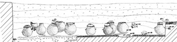
Some of the most salient evidence of the Aztec period occupation comes from the Museo locality, particularly the the West complex (Figure 2), where later construction consisting of rather insubstantial stone walls, creating a series of small rooms, overlay the floor of a portion of one of the Tollan phase structures. Additional reoccupation activity included 33 burials placed in various areas of the Tollan phase structures (Gómez Serafín et al. Reference Serafín, Susana, Sansores and Fernández Dávila1994:Figure 8). Of particular interest is an elongated east–west cluster of 21 burials and 19 globular ollas in the central patio (Figures 2b and 9). The majority of the burials were children, both primary and secondary burials, some with grave goods, and two of the ollas are known to have contained a child burial (Entierro 86; Gómez Serafín et al. Reference Serafín, Susana, Sansores and Fernández Dávila1994:116–117, Foto 29). The authors were unable to provide any information about the contents of the other ollas, “por circunstancias ajenas” (Reference Serafín, Susana, Sansores and Fernández Dávila1994:129), but suggested that they, too, had held burials.
East–west distribution of Aztec period burials and ollas probably containing burials in the patio of a Tollan phase residential compound in the Museo locality (Gómez Serafín et al. Reference Serafín, Susana, Sansores and Fernández Dávila1994:Figure 52).

Despite their placement in a common location and in a similar elongated cluster, the burials and ollas appear to have been deposited independently of each other. The ollas were deposited directly or almost directly on the patio floor (Figure 9), while the burials occurred throughout much of the overlying soil layers, hence the ollas appear to have been deposited shortly after the compound was abandoned, while the burials would have been deposited over a longer period of time.
Although no data are available concerning their contents, it is reasonable to assume that the other ollas likewise contained burials which, given their size based on published photographs, would likely have been subadults. Similar ollas containing burials were found in association with Aztec reoccupation of a Tollan phase residential compound at Daini in the Tula river valley, northeast of Tula Grande (Peña and Rodriguez Reference Peña, Rodríguez and Matos1976). The majority of the ollas in the Museo locality patio had been “killed” by puncturing, and at least ten were capped with inverted bowls (Figure 9). The latter ten included an Orange Polychrome and other Aztec vessels but also diagnostic Tollan phase vessels (Gómez Serafín et al. Reference Serafín, Susana, Sansores and Fernández Dávila1994:129). The use of Tollan phases vessels as Aztec mortuary furniture is without precedent, but appears to be a very specific example of a much larger pattern of Aztec veneration of objects taken from the ruins of Tula (Duran Reference Duran1964:511; López Luján and López Austin Reference López Luján, López Austin, Fash and Luján2009; Sahagún Reference Sahagún1961:165).
Additional burials were encountered in other parts of the same compound (Gómez Serafín et al. Reference Serafín, Susana, Sansores and Fernández Dávila1994:Figure 8). Two radiocarbon samples recovered from the reoccupation contexts in the compound produced probability ranges in the fifteenth through seventeenth centuries a.d. (Table 1:B', D').
Las Plazas and Edificio J Localities
During exploratory excavations at Las Pilas, a single radiocarbon sample was recovered that yielded a date with an age likewise in the fifteenth through seventeenth centuries a.d. (Table 1:A'), consistent with other evidence of a strong Aztec presence at Tula Grande.
During excavations of the badly damaged structure atop Edificio J, a burial associated with a probable Aztec II figurine was encountered in front of the exterior wall on the plaza side of the structure.
CHRONOLOGY
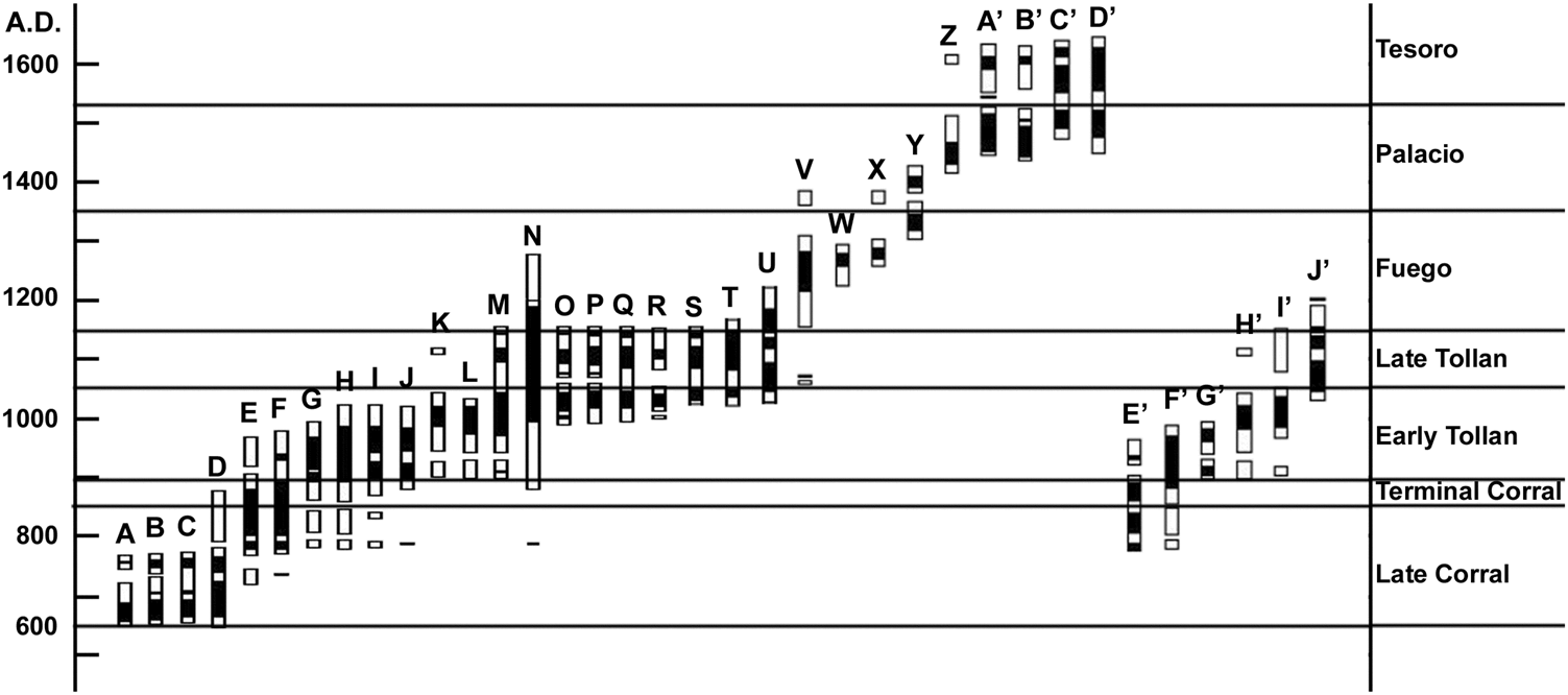
The 36 radiocarbon dates detailed in the preceding sections were processed by Magdalena de los Ríos Paredes at INAH's Dating and Analysis Laboratory, and recalibrated by the authors using the CALIB Radiocarbon Calibration Program, version 7.0.4 (Stuiver and Reimer Reference Stuiver and Reimer1993). The dates and supporting information are presented in Table 1, and their two-sigma (95 percent) ranges are represented graphically in Figure 10. We elected to use two-sigma range bar graphs, rather than full probability curves, to depict the date ranges because we believe it better facilitates pattern recognition among large numbers of dates. The dates are arranged by median probability, a point estimate recommended by Telford et al. (Reference Telford, Heegaard and Birks2004).
Calibrated radiocarbon dates obtained by Proyecto Tula ’80, arranged by median probability date (Telford et al. Reference Telford, Heegaard and Birks2004). Solid portion of bar delineates 1-sigma (68 percent) range, while light portion delineates 2-sigma (approximately 95 percent) range. Calibration performed using CALIB Radiocarbon Calibration Program Version 7.0.4 (Stuiver and Reimer Reference Stuiver and Reimer1993).

As seen in Figure 10, the dates span a period of approximately 1000 years and form an overlapping sequence, suggesting continuous occupation. As noted in Table 1, the majority of the dated samples came from contexts associated with specific ceramic complexes established by Cobean (Table 3), and in virtually all cases fall within the time range currently established for the corresponding ceramic phases (Table 2; see also Healan et al. Reference Healan, H. Cobean and T. Bowsher2021).
The four earliest dates (Figure 10:A–D) are from Epiclassic contexts at the Cerro Malinche and Museo localities, and indicate that occupation in these areas began by at least the first part of the seventh century a.d. (Paredes Reference Paredes1998a, Reference Paredes1998b, Reference Paredes2002, Reference Paredes and García2004, Reference Paredes and Daneels2009), hence they overlap in time with the Early Corral phase settlement at Tula Chico (Cobean et al. Reference Cobean, Healan and Suárez2021). These four, plus the 17 subsequent dates (Figure 10:A–U), form an overlapping sequence that indicates continuous occupation for all of the pre-Aztec period. That virtually none of the dates from Tollan phase contexts (Figure 10:K–U) extends beyond a.d. 1150 agrees with previous suggestions (Healan Reference Healan2012:96) that this date marks the approximate end of the Tollan phase and the Tollan phase city, although it probably continued to be occupied by a remnant population.
It should be noted that the only gap in the overlapping sequence of dates occurs between the latest Tollan phase date and the earliest Aztec date (Figure 10:U, V). Although this might indicate a hiatus between Tula's demise and the arrival of the Aztecs, it could also mean that the Aztec dates are not a representative sample of the full time span of the Aztec occupation at Tula.
In Figure 10:E–J, the pre-Aztec dates from Tula Grande are presented separately from the others to emphasize that the Proyecto Tula ’80 dates include a sizeable addition to the few dates that previously existed for Tula Grande. Two previously published dates are included (Figure 10:E, G) that were obtained during excavation of the massive North Platform supporting the monumental architecture on Tula Grande's north side (Sterpone Reference Sterpone Canuto2001–2002). Five of the dates from Tula Grande (Figure 10:F–J) came from Tollan phase contexts and span the Early Tollan and Late Tollan phases. The other date (Figure 10:E) falls mainly in the Late Corral phase and Terminal Corral phase time range, and was obtained for a radiocarbon sample from a probable domestic hearth beneath the massive North Platform associated with Terminal Corral complex ceramics. Taken together, these dates suggest that the construction of the Tula Grande monumental complex was initiated around the beginning of the Terminal Corral phase (Healan et al. Reference Healan, H. Cobean and T. Bowsher2021).
DISCUSSION
The widespread impact of the various modern construction projects that prompted the Proyecto Tula ’80 provided an opportunity to sample a large number of localities within the ancient city. The rich variety of artifacts, architectural remains, and the 36 radiocarbon dates obtained from these investigations have made a substantial contribution to our knowledge of Tula's settlement history, its internal structure, daily life, and other practices of its inhabitants, and their relationship to other areas of Mesoamerica.
One of the most substantial contributions is the considerable light shed on Tula's earliest (Epiclassic) settlement. Excavations in both the Cerro Malinche and Museo localities encountered occupations dated as early as the dates reported by Mastache et al. (Reference Mastache, Healan, Cobean, Fash and Luján2009) for Tula Chico, although recently obtained radiocarbon dates suggest an earlier (Middle Classic) beginning date for Tula Chico (Healan et al. Reference Healan, H. Cobean and T. Bowsher2021). Moreover, the presence of Prado complex ceramics in both the Museo and Cerro Malinche localities demonstrates that, contrary to previous beliefs, this complex was not restricted at Tula to Tula Chico. While it is no surprise that Early Corral phase occupation was encountered in the Museo locality, which falls within the previously estimated limits of the Epiclassic settlement, its occurrence at Cerro Malinche offers a new perspective on Tula's overall size during this period.
However, we do not know that Cerro Malinche and Tula Chico were part of a single Epiclassic settlement, since the two are separated by a river valley where two previous surveys found no evidence of Corral phase occupation. It is possible that the two were distinct settlements atop neighboring hills, in the same manner as La Mesa and the other Coyotlatelco-associated hilltop sites at the eastern end of the Tula valley (Healan et al. Reference Healan, H. Cobean and T. Bowsher2021:Figure 2). Moreover, the stylistic differences in the ceramics of Tula Chico and Cerro Malinche noted above are reminiscent of stylistic differences previously noted among the ceramics of La Mesa and the other hilltop sites, which were thought to reflect different places of origin (Healan and Cobean Reference Healan, Cobean and Beekman2019).
However, the absence of Corral phase surface ceramics in the area between Cerro Malinche and Tula Chico does not necessarily mean that no such occupation had existed there, given that there is little correlation between surface evidence and subsurface reality for the pre-Tollan phase occupation at Tula. Indeed, one of the reasons the Museo locality was selected as the site for the new museum was its sparse surface material, which suggested to those in charge that few, if any, prehispanic remains existed below the surface! In retrospect, the spatial distribution of surface material appears to be an unreliable indicator of the extent of Epiclassic period settlement.
Despite its limited nature, excavation of the Corral phase structures in the Museo locality was sufficient to provide the first detailed information on Epiclassic period domestic architecture at Tula, revealing strong similarities in form, mode of construction, and architectural details that provide additional evidence of cultural continuity between Tula's earliest settlement and the Early Postclassic city. The apparently closely spaced arrangement of Epiclassic residential structures in the Museo locality implies a settlement density comparable to the later city, at least at a local level.
The Epiclassic material inventory includes various elements that indicate close ties to the Bajío and West Mexico, including (1) the burial of canids, among them Xoloescuintli, a species native to West Mexico; (2) burials of Psittaciformes, another group of species native to West Mexico; and (3) marine shells native to the Pacific Ocean. Archaeological evidence from previous research indicates that Tula was founded by an intrusive population associated with Coyotlatelco ceramics that appeared in the Tula region sometime during the middle or late Classic period (Healan et al. Reference Healan, H. Cobean and T. Bowsher2021; Mastache and Cobean Reference Mastache, Cobean, Diehl and Berlo1989), which current evidence suggests originated in the Bajío (Beekman Reference Beekman, Baker and Tsuda2015; Beekman and Christianson Reference Beekman and Christensen2003; Hernández and Healan Reference Hernández, Healan and Beekman2019; Paredes Reference Paredes and García2004). This issue is the subject of ongoing investigations that include studies of genetics (Paredes Reference Paredes1998d, Reference Paredes2020; Vargas et al. Reference Vargas, Manzanilla and Paredes1998).
However, the migration process need not involve movement of large numbers of individuals over long distances. The presence of both Corral and Prado ceramics at various sites in southeast Queretaro (Nalda Reference Nalda, Crespo and Brambila1991:50; Saint-Charles Zetina and Enríquez Farías Reference Saint-Charles Zetina, Enríquez Farías and Valverde2006:310–317) suggests that initial Coyotlatelco settlement in the Tula region could have involved intraregional, short-distance migration from areas as close as 70 km, by individuals likely familiar with the Tula region and who could have had kinship or other ties to the people who lived there. In this way, short-distance migration could have involved numerous small episodes of migration and “back migration” over time, although this does not mean that episodes of long-distance migration may not also have occurred. Both possibilities might be addressed through DNA and isotopic research (e.g., Spence et al. Reference Spence, White, Cobean, Mastache and Longstaffe2006).
The Proyecto Tula ’80 investigations confirmed the urban character of Tollan phase Tula, having extensively explored residential structures at four different localities (Cerro Malinche, Museo, Vivero, La Nopalera). Regardless of whether Cerro Malinche was part of Epiclassic Tula, the continuous surface distribution of Tollan phase ceramics provides clear evidence that it was indeed part of the Tollan phase city (Healan and Stoutamire Reference Healan, Stoutamire and Healan1989:Figure 13.9; Yadeun Reference Yadeun Angulo1975:Figures 19 and 20). The sumptuous character of its residential architecture suggests the hilltop was an elite barrio, which is not surprising given what must have been its highly valued location. Perhaps the structures exposed in the Zapata II locality were also part of an elite barrio, whose inhabitants lived in structures beyond the limits of excavation.
At the same time, the presence of high quality residential architecture and exotic goods in other localities, including Museo and Vivero, agrees with other authors who have suggested that high-status families lived throughout the city rather than being restricted to specific parts (Gamboa Cabezas and Healan Reference Gamboa Cabezas and Healan2021; Healan Reference Healan, Manzanilla and Chapdelaine2009; Paredes Reference Paredes1990). It appears that some, perhaps many barrios, included families with a wide range of social status (e.g., Getino Granados Reference Getino Granados2021). It is noteworthy that exotic goods were not restricted to what might be considered elite residences, but also occur in more mundane residential compounds, perhaps including the exotic vessel cache in Structure 3, North Complex, Museo Locality and the similar cache previously discovered in the Canal locality (Diehl et al. Reference Diehl, Lomas and Wynn1974). The ability of non-elites to acquire exotic goods suggests the existence of trade networks whereby such goods were procured and moved, and modes of distribution at the consumer end, involving markets, peddlers, or other agents. These exotic goods indicate ties to specific areas of northern, southern, and western Mesoamerica, and could also indicate the presence of foreigners at Tula, and perhaps its multi-ethnic composition, as suggested previously (Paredes Reference Paredes and Manzanilla2005a, Reference Paredes2020).
It was not surprising that evidence of Aztec occupation was encountered in Building J and Las Plazas, given prior evidence of this at Tula Grande, but it must be emphasized that an Aztec presence was also encountered in virtually all of the other localities investigated during the Proyecto Tula ’80, often of a very specific character. For the most part, little or no new construction was involved, but rather reoccupation of existing Tollan phase structures. Equally important is that reoccupation almost invariably included burial of individuals in the ruins of the Tollan phase occupation, a practice that appears to have been widespread during the Aztec occupation (Gamboa Cabezas and Healan Reference Gamboa Cabezas and Healan2021; Getino Granados Reference Getino Granados2021; Healan et al. Reference Healan, H. Cobean and T. Bowsher2021). In some cases, the burials were the most salient, if not the only evidence of an Aztec presence. An extreme example is the 21 burials and 19 ollas in the patio of the Tollan phase residential compound in the Museo locality. We suggest that the paradoxical scenario of abundant burials, but relatively sparse evidence of actual occupation, indicates the systematic interment of individuals who were brought to Tula from elsewhere. The possibility that more individuals were buried there than lived there could have been evaluated more objectively had the entire compound been exposed and sufficiently dated so that the number of reoccupying families and duration of occupation could be estimated.
The nine radiocarbon dates obtained for contexts associated with Aztec ceramics collectively span the thirteenth through seventeenth centuries a.d. (Figure 10:D–V), and provide the first objective dating of the Aztec occupation at Tula, although they cannot be assumed to comprise a representative sample. The four earliest dates fall completely or nearly completely within the Fuego phase, the 200-year range currently assigned to the Aztec II period in the Basin of Mexico (Tables 2 and 3), although none of the four are from contexts associated with diagnostic Aztec II ceramics. The first two are associated with the reoccupation of a Tollan phase structure in the Vivero locality used as an obsidian workshop, whose ceramics consisted principally of undiagnostic utilitarian wares. We have confidence in the veracity of these four dates, and think it likely that the lack of associated diagnostic Aztec II ceramics is a sampling error. Indeed, the alternative explanation, that the four are from Aztec III contexts, would place this ceramic complex in Tula as much as two centuries before its appearance in other parts of central Mexico, which is almost certainly not the case.
It is unfortunate, given its importance in determining the time of Tollan phase Tula's demise and/or the appearance of the Aztec in Tula, that apart from a single, problematic date (Figure 10:Z), no obvious Aztec II contexts were dated. This information would also be of considerable value in refining the chronology of the Aztec period in central Mexico. The gap between the latest Tollan phase date and the earliest Aztec date in Figure 10, the only apparent gap in the 1000-year sequence of two-sigma ranges, could indicate that Tula had been abandoned before the arrival of the Aztec, or it could simply reflect a sampling error. Obviously, the answer requires further investigation.
RESUMEN
Entre 1980 y 1983, el INAH efectuó un programa integral de arqueología de salvamiento en Tula, Hidalgo, en respuesta a dos proyectos planificados de construcción que incluyeron la construcción de una vía de ferrocarril para un tren de alta velocidad, y un complejo grande de turismo con un museo y un parque botánico. Se efectuaron investigaciones en 11 localidades distintas, y se encontraron restos arqueológicos en todas, lo que condujo a excavaciones más intensivas en nueve localidades donde se encontraron restos arquitectónicos. En el transcurso de las excavaciones, se recuperaron cerámica, lítica, y otros artefactos de ocupación, además de restos faunísticos, aproximadamente 250 entierros humanos y de animales, y 36 fechas de radiocarbón, que abarcan los períodos epiclásico, posclásico temprano, y posclásico tardío.
La ocupación más temprana procede de las fases Corral temprano y Corral tardío del período epiclásico (alrededor de los 650–850 d.C.), que se encontró en las excavaciones en dos localidades (Cerro Malinche y Museo). Dichas excavaciones incluyeron el descubrimiento de los primeros restos arquitectónicos de habitaciones epiclásicas en Tula, que exhiben muchas ligas con la arquitectura residencial de la ciudad posterior del posclásico temprano, una indicación de la continuidad cultural que existía por toda la ocupación del asentamiento pre-azteca en Tula. Entre los entierros epiclásicos se encontraron enterramientos de perros, incluyendo la especie xoloezcuintli del occidente de México. El descubrimiento de ocupación epiclásica en el Cerro Malinche sugiere que el asentamiento temprano de Tula fue más grande de lo pensado previamente.
En las excavaciones en Cerro Malinche también se encontró evidencia de ocupación que muestra las características de la fase Corral terminal (alrededor de los 850–900 d.C.), una fase transicional previamente definida en una manera tentativa, y por lo tanto ofrece más evidencia de su veracidad, así como su carácter transicional, no sólo en la cerámica, sino en la arquitectura.
La mayoría de los restos recuperados en el Proyecto Tula ’80 vino de las fases Tollan temprano y Tollan tardío (900–1150 d.C.), y se encontraron en todas las 11 localidades investigadas. Durante esta época, parece que Cerro Malinche era un barrio de élite, y tal vez la localidad de Zapata II, donde se encontraron templos y salas con una iconografía muy rica y única. Sin embargo, el descubrimiento de conjuntos residenciales de alta calidad en varios de las otras localidades indica que los élites no eran restringidos a una sola parte de la ciudad, sino fueron dispersos por toda. Además, el descubrimiento de cerámica fina y otras cosas exóticas en casas ordinarias indica que incluso la población en general disfrutaba del acceso a tales bienes.
Otro de los logros más significativos del Proyecto Tula ’80 fue la contribución sustancial al conocimiento de la época azteca en Tula. Restos de la ocupación azteca se encontraron en ocho de las localidades investigadas, y en la mayoría de los casos implicó reocupación, con relativamente poca modificación, de estructuras preexistentes de la fase Tollan. Dicha reocupación casi siempre incluyó enterramiento en las ruinas de la ocupación tolteca, y en muchos casos fue la evidencia más sobresaliente de la presencia azteca, si no la única. Esto plantea la posibilidad de que algunos individuos difuntos fueron llevados a Tula desde otros lugares para ser enterrados en lo que fueron consideradas las ruinas de la antigua Tollan de leyenda azteca.
Las 36 fechas de radiocarbón que se obtuvieron presentan un registro de fechas traslapadas que abarcan un período de aproximadamente mil años. De importancia particular es que las fechas determinadas por radiocarbón acordaron con las fechas basadas en la cronología cerámica establecida por Cobean (Reference Cobean1990) y otros.
ACKNOWLEDGMENTS
The authors wish to thank Elizabeth Jiménez García for generously allowing us to reproduce some of her photographs.