

Introduction
In recent years, the concept of a prosperous late antique eastern Mediterranean has become widely established and accepted in scholarship. Thanks to archaeological survey and excavation work, evidence has revealed expanding rural settlement across this broad territory in the period between circa the fourth and seventh centuries.Footnote 2 Expanding rural settlement, usually identified by datable ceramic scatter, terracing, and architectural remains in the rural landscape, has been interpreted as evidence for ‘prosperity’ in the late antique countryside. Moreover, evidence, such as ceramics, together with oil or wine presses, has added to our knowledge of the ways in which geographical areas were tapping into local, regional and inter-regional economic networks and the impact such connectivity had on rural settlement. Acknowledgement of such evidence has essentially normalized the idea of ‘prosperity’ for the eastern Mediterranean region in Late Antiquity.
Evidence of expanding rural settlement cannot be denied in certain regions of the eastern Mediterranean in the late antique period. However, applying such a blanket-statement to the entire geographic territory should be approached with caution.Footnote 3 The generalized application of a notion of prosperity to the eastern Mediterranean as a whole has masked the importance of recognizing divergent settlement development on micro-regional levels in this vast and varied geographic area and hinders a more refined understanding of the economy of the eastern Mediterranean in this period.Footnote 4
By taking Lycia as a case study, the following article will question the generalizing notion of late antique prosperity and demonstrate that this narrative may skew nuances of settlement development, if variation is not recognized. I will first discuss methodological challenges in pursuing a regional study of settlement development and will briefly present historiography concerning Lycia. I will then analyse available archaeological evidence for settlement in the province, with a focus on interior areas.
I will argue that, contrary to previous theories of Lycian settlement development, an examination of the available archaeological evidence reveals that the province in its entirety did not experience ‘prosperity’ in this period. With the exception of restricted pockets of coastal areas, some settlements, particularly those of the interior, did not experience prosperity, but rather the opposite occurred. This may have been due to population migration; inhabitants may have moved outside of urban centres to rural locations or perhaps migrated to coastal areas, although this remains an open question.
Defining prosperity
As alluded to above, terms such as ‘wealthy’, ‘prosperous’, or ‘flourishing’, are often used synonymously to describe settlement expansion. Terminology surrounding the development of settlement, such as expansion, growth, intensification, as opposed to decline, decrease, or abatement (which is somewhat intrinsically linked with broader debate concerning the empire) as well as the scale on which ‘wealth’ is measured in primary sources is currently being re-evaluated in scholarship.Footnote 5 Nevertheless, terms often used to describe development are subjective and do not necessarily give clear meanings as to what they are describing and how they are qualified. Their meanings are essentially left to be determined by the value-judgements of the reader. On a similar yet contrary note, the term ‘ruralization’ generally used to describe a move away from urban monumental building and ordered site planning, need not imply an economic decline of a settlement, but may be interpreted as such.
How ‘wealth’ is identified and evaluated in archaeological material has received much attention. The identification of churches in urban and rural areas alike has led scholars to conclude that inhabitants were able to generate surplus wealth that was invested in the construction of religious structures. Thus, churches have been viewed as potential indicators of settlement prosperity.Footnote 6 While this view has its supporters, it also has its critics as churches were inherently new in the landscape in Late Antiquity.Footnote 7 It has been argued that churches do not accurately reflect settlement wealth, but merely the proliferation of Christianity.Footnote 8 References to high-quality craftsmanship or materials in the descriptions of religious remains, such as marble, may point towards degrees of investment, but such material does not survive often in its original context in the archaeological record. Churches are also frequently studied in isolation and lack settlement context. Nevertheless, churches are sometimes the only evidence mentioned for late antique occupation of sites in publications when other archaeological data is unavailable or is simply not the interest of scholars. As a result, we are somewhat forced to focus on church construction when analysing settlement development when other categories of evidence are lacking. Nonetheless, no matter how large or small the structure, the construction of a church would have required some sort of investment, planning and workforce. Thus, to an extent the presence of churches ought to be considered in an evaluation of a settlement's building activity.Footnote 9
It is difficult to resolve issues of terminology or settle on appropriate replacement terms for describing settlement change that do not carry value-based implications. Nevertheless, a combination of a comparative study of construction works across centuries and/or a comparison of settlement architecture micro-regionally when possible, is an instructive way to analyse settlement development. In this way, settlements are understood in their own relative developmental processes, as well as with the additional benefit of being placed in a broader geographic context. The importance of adopting relative and regional approaches not only provides a more comprehensive study of settlement development in context, but highlights lacunae in our evidence that, it is hoped, may be filled with future research.
Lycia: location and previous research
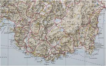
Lycia, located in the southwestern corner of Turkey, is a region that borders the Mediterranean Sea and encompasses a mountainous interior (map 1). The region's geographic location has been a factor in generating scholarly interest as the province appears to be well-placed in proximity to the lanes of maritime traffic. Lycia's location bordering the major maritime route of the eastern Mediterranean and its natural harbours has therefore been viewed as key factors in facilitating the region's prosperity in Roman and late antique times.Footnote 10 The importance of maritime activity in the region may be identified in the construction of the Hadrianic period warehouses at the major harbours of Patara and Andriake.Footnote 11
Map of Lycia (H. Hellenkemper and F. Hild (eds.), Lykien und Pamphylien, Tabula Imperii Byzantini 8 (Vienna 2004) ‘Lykien und Pamphylien (1:800.000 Ausfaltkarte)’. Cropped.)

Over the past few decades, Lycia has increasingly become the subject of archaeological interest. While past attention has focused on the study of eye-catching tomb monuments and coastal cities, more recently interest has turned to the rural development of the region and to the late antique period. However, research of coastal areas still predominates and little has been done to synthesize the archaeological material that has emerged from the past thirty years of study, resulting in a disjointed picture of settlement development.
The legacy of Martin Harrison, recognized as one of the pioneers of archaeological investigation of Lycia, remains the fundamental starting point for research of the region. Writing in the 1960s to the 1980s, his theory of a late antique migration of wealth to inland areas of the province and a decline of coastal population is no longer supported by more recent archaeological study.Footnote 12 In a 1994 article, Clive Foss largely rewrote the late antique picture of Lycia, pointing to evidence of settlements with churches on the Lycian coast.Footnote 13 Foss argued that Lycia was a prosperous region in Late Antiquity. He states that trade of agricultural products essentially ‘brought the whole region to a remarkable and unparalleled level of prosperity under the Romans and in late antiquity’.Footnote 14 He theorized that a system of interdependence between inland settlements, cities and the coast, was the foundational economic network for the region. It is a very different picture of late antique Lycia than that of Harrison.
The difficulties raised by these aforementioned theories lie in their geographical focus. On the one hand, Foss makes clear that his focus is the coastal areas of Lycia but, on the other hand, states, ‘Lycia prospered in late antiquity’.Footnote 15 Such a statement is a rather hasty conclusion based on the archaeological evidence from a narrow geographical area and gives an inaccurate impression of provincial prosperity.Footnote 16 Interestingly, in a paper written the previous year (1993), Foss briefly mentions the possible decline of interior areas of the province at the expense of the coast, briefly attributing this development to insecurities and economic changes, but does not pursue the issue in his subsequent work.Footnote 17 As will be discussed below, a reassessment of coastal settlement reveals that only restricted areas of the coast experienced what might be considered to be ‘prosperity’ in Late Antiquity, but does not apply to the entire Lycian coastline. Moreover, consideration of interior settlement further challenges the idea of a province flourishing in unity. It has been over twenty years since Foss' article. As research in Lycia has progressed, the time is now right to reassess this picture of a prosperous late antique coast and province.
Methodology
A useful reference source for historical and archaeological information of Lycia is the Tabula Imperii Byzantini volume 8 of Hansgerd Hellenkemper and Friedrich Hild (hereafter TIB), but the publication has its limitations.Footnote 18 These are due in part to the variegated nature of the archaeological research that it draws upon, thus highlighting the challenges of synthesizing studies that differ in methodology, focus, and qualitative and quantitative data. A lack of detail in site entries makes it difficult to conceptualize the size of a settlement or quantify remains and frustrates an economic analysis of settlements. If there is no mention of agricultural presses, terraces, or harbour facilities for example, it is difficult to determine the potential economic sources of a settlement. Nevertheless, approached with caution, the TIB is a monumental achievement and allows for the possibility of a regional analysis.
The information provided in the TIB can be supplemented with more recent research, but issues arise when attempting to consolidate evidence that derives from various types of studies (excavation versus survey). It is also difficult at times to discern whether or not different publications are referring to the same remains (especially churches) if only general descriptions are given. There is also the possibility that brief archaeological reports do not present all finds, thus limiting our accessibility to important information. As ancient populations were certainly not static, the nature of transhumance may also have a bearing on the evidence available for study, as the movement of inhabitants and non-permanent structures may not be identifiable in the archaeological record thus in turn skewing our perception of the method and location of settlement.Footnote 19
Furthermore, ambiguous chronological terminology across publications often makes it difficult to determine the date of remains or continuity of settlement. Challenges in dating material culture are omnipresent, especially when it concerns religious structures that are often dated based on architectural comparisons. It is on this point that another aspect should be borne in mind when approaching the dating of Lycian evidence. The conflation of Foss' work and the narrative of eastern Mediterranean late antique prosperity, as well as less than precise dating methods, may result in an over-identification of remains attributed to the period of Late Antiquity. As a result, there may be an inflation not only of the number of churches attributed to Late Antiquity, but also of settlements in general.
As the southcentral region of the province has been extensively discussed in previous studies, this southern zone will receive only a cursory overview. Instead, the inland areas of Lycia will be the focus of discussion. As it is not possible to discuss all Lycian sites in detail, it is necessary to focus on particular settlements. Lastly, it is important to keep in mind that the following discussion is based upon the information available in publications and the current state of research.
Southcentral coast
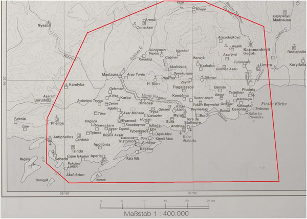
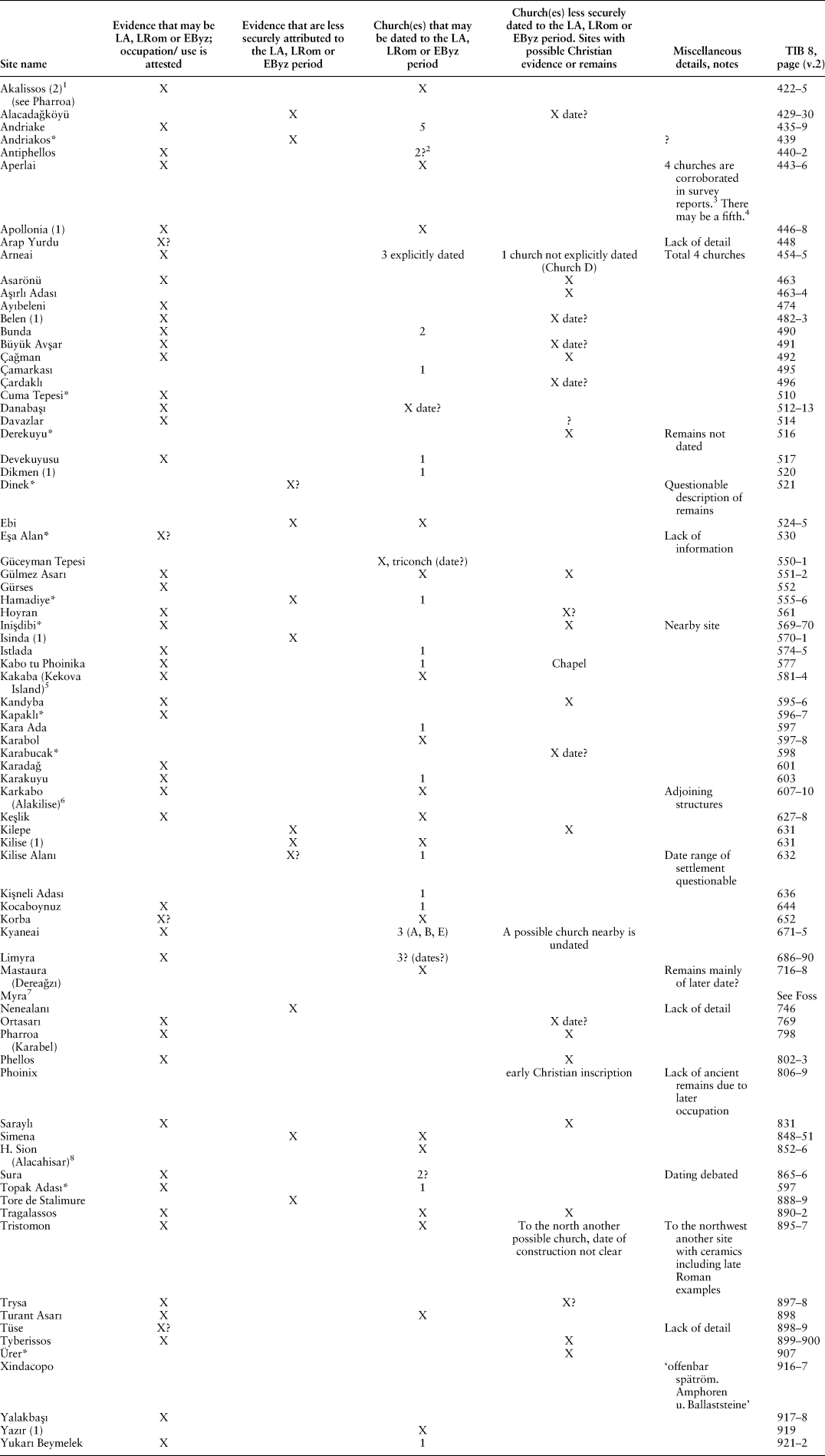
The significance of Lycia's southcentral coastal region lies in the dense concentration of settlement in this area. The sixth-century Life of Saint Nicholas of Sion refers to the Alacadaǧ region behind Myra and gives an impression of a densely settled territory.Footnote 20 There have been attempts to locate the villages and holy places mentioned in the Life to varying degrees of success.Footnote 21 Table 1 compiles information concerning a sample of sites in the area as described in the TIB (map 2).
Map of the southcentral coastal area of Lycia with the sample area considered for analysis indicated (Table 1) (H. Hellenkemper and F. Hild (eds.), Lykien und Pamphylien, Tabula Imperii Byzantini 8 (Vienna 2004) ‘Sonderkarte 1. Zentrallykien’. Modified.)

Sample overview list of settlements in the southcentral coast of Lycia between the Limyros River Valley and Antiphellos with late antique or possible late antique remains according to the TIB 8 (indicated on Map 2)

Source: H. Hellenkemper and F. Hild (eds.), Lykien und Pamphylien, Tabula Imperii Byzantini 8 (Wien 2004)
NB: Entries include nearby remains as listed in the TIB. The only exception is Topak Adası because it is an island.
* Not indicated on Map 2.
LA: Late Antique; LRom: late Roman; EByz: early Byzantine
1 Compare to Harrison, ‘Churches and chapels’, 131–6.
2 See also, M. Zimmermann, ‘Survey in Phellos (Central Lycia) 2003’, ANMED 2 (2004) 104.
3 Foss, ‘Lycian coast’, 17; R. L. Hohlfelder, R. L. Vann, ‘Cabotage at Aperlae in Ancient Lycia’, The International Journal of Nautical Archaeology 29.1 (2000), 133 state there are four churches; R. L. Hohlfelder, R. L. Vann, ‘A church beneath the sea at Aperlae, Lycia’, ADALYA 4 (1999–2000) 209 state there are three churches in the urban centre and a fourth is submerged.
4 B. Leadbetter, ‘Diocletian and the purple mile of Aperlae’, Epigraphica Anatolica 36 (2003) 130.
5 More recent survey of the island has led to the identification of ecclesiastical structures although the dates of some of these buildings are not given. For recent work see E. Aslan, ‘Harbor surveys in Kekova Region in 2010: Dolichiste (Kekova Adası) Harbor Areas’, ANMED 9 (2011) 231–5; E. Aslan, ‘Archaeological land and underwater surveys at Kekova Island in 2015’, ANMED 14 (2016) 175–82.
6 For churches in the Alaca Daǧ area in general, see Harrison, ‘Churches and chapels’.
7 See Foss, ‘Lycian coast’, 23–4; Foss, ‘Cities and villages’, 313–15.
8 Harrison considered the church at Karabel to be Holy Sion, Harrison, ‘Churches and chapels’, 131–5, 150. This identification is supported by Foss, Foss, ‘Cities and villages’, 309.
What is interesting about the southern coastline is the density of settlement in the central zone in relation to the rest of the coast. Looking westward, there is a decrease in identified settlements located between Antiphellos and the Ölüdeniz area, Patara being the only notable exception. The drop off of settlement beyond this coastal zone is striking and will be explored further below. The final point to be made is the question of whether or not the remarkable settlement density of the southcentral area is an accurate representation of the settlement development of Lycia in general, or is more a reflection of where the bulk of archaeological study has been conducted.
Western Lycia
For the western coast of Lycia (here considered as the area west of the Xanthos river northward to the Fethiye gulf), information concerning the northwestern part of this coastline predominates as the gulf of Telmessos (modern Fethiye) and the area of Ölüdeniz (directly to the south of Telmessos) have been the subject of recent archaeological research. The gulf of Telmessos is thought of as being an important maritime node in the region because of its potential port suitability.Footnote 22 Unfortunately, Telmessos/Ölüdeniz is largely overbuilt by modern construction thus limiting access to ancient remains. Nevertheless, the vicinity of Telmessos/Ölüdeniz is thought to have undergone development in the late antique period as evidence of settlement dating to this period in the area of the gulf suggests.Footnote 23
The relatively well-preserved remains found on Gemiler and Karacaören Islands have recently been the subject of survey and excavation by a Japanese team.Footnote 24 Four churches and various other buildings have been identified on Gemiler Island and although less built up, a church complex has been identified on the neighbouring Karacaören Island. Generally, the significant development of these islands has been dated to Late Antiquity.Footnote 25
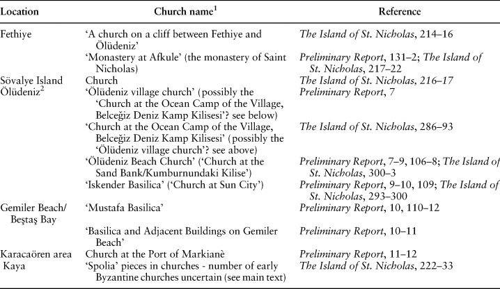
The adjacent coastlines opposite these islands and nearby area have been explored by the same team as well. At least nine churches have been identified in the Telmessos/Ölüdeniz area (Table 2). It is possible that there were additional churches in this coastal area obscured by modern construction. Although it is implied by the archaeologists that the churches may be attributed to the early Byzantine period, the dating of the structures is not secure. For example, re-used architectural materials have been identified in some buildings, which are interpreted by the archaeologists as indicating the early Byzantine origin of these churches (as at the so-called ‘Kato Panagia church’ and at the ‘monastery called Afkule’).Footnote 26 However, this material may be displaced and is not necessarily reliable dating evidence. As a result, the number of early Byzantine churches in this northwestern area remains an approximation.
Churches identified in the area of Telmessos (Fethiye) and Ölüdeniz as published in Tsuji (1995) and Asano (2010)

Source: S. Tsuji (ed.), The survey of early Byzantine sites in Ölüdeniz Area (Lycia, Turkey) The first preliminary report (Osaka 1995); K. Asano (ed.), The Island of St. Nicholas. Excavation and survey of the Gemiler Island Area, Lycia, Turkey (Osaka 2010)
1 The names of the churches differ across publications.
2 Based on the very brief description of the so-called ‘Ölüdeniz village church’ in the Preliminary Report (no plan of the church is given), it is difficult to determine if it is the same building as the ‘Church at the Ocean Camp of the Village, Belceǧiz Deniz Kamp Kilisesi’ described in The Island of St. Nicholas. The different names used across publications cause confusion.
To the south of the Telemessos/Ölüdeniz area, it appears that this area of coastline was home to only scattered settlements, according to the TIB. Apart from Sidyma (which is the only site located in the southwestern area with possible evidence for multiple churches), and a few other settlements such as Karaca Burun, Kalabatia and Pydnai, the southwestern coast appears to be less densely settled than the area to the north.Footnote 27 The disparity in the density of settlement identified in the southwest is even more apparent when compared to the southcentral coastal zone. This suggests that the entire western coastline of the province did not experience the same degree of settlement in the late antique period regardless of its potential proximity to maritime traffic.
Eastern LyciaFootnote 28
In eastern Lycia (the area east of the Limyros River to modern Kemer), coastal/near-coastal loci where late antique remains have been recorded include Rhodiapolis,Footnote 29 Korydalla,Footnote 30 Gagai,Footnote 31 and Melanippe,Footnote 32 but two major sites dominate the eastern coastline proper, Phaselis and Olympos.
Presumably, the advantage of encompassing harbours and proximity to maritime exchange underlay the economy of Phaselis.Footnote 33 It has also been suggested that murex production may have taken place in the city, as shells of hexaplex trunculus and potential work areas have been identified, which would have strengthened the city's economy.Footnote 34 Numerous repairs and structural renovations across the city have been dated to the late antique period.Footnote 35 Four early Byzantine churches are recorded in the TIB.Footnote 36 Two additional early Byzantine churches have been identified in the area of İnce Burun.Footnote 37 According to more recent survey reports, there appear to be additional churches on the acropolis and in the territory of Phaselis. However, detailed information is not yet available.Footnote 38
Olympos is the second major coastal settlement on the eastern coast. Six early Byzantine basilicas have been identified in the city, making it a settlement with one of the highest number of such churches in Lycia.Footnote 39 The city appears to have expanded in the early Byzantine period seemingly surpassing the size and population of the Roman period.Footnote 40 Notable buildings include the so-called ‘episcopal palace’ which encompassed a church, peristyle and various other rooms.Footnote 41 It has been postulated that this building may have played the role of a healing shrine that drew visitors to the city and thus underlay the economy of Olympos along with the city's role in trade.Footnote 42
Recent surveys conducted in the area of the Bey mountain range suggest that, in general, Roman period settlement grew from earlier periods and continued in the Byzantine period.Footnote 43 In the area under consideration here, a combination of recent survey results and information from the TIB record sites of interest. Examples of settlements that encompass notable remains and churches include (note that there are differences in the dating of remains between publications): Idebessos,Footnote 44 Kitinaura,Footnote 45 Çakmak,Footnote 46 Idyros,Footnote 47 Yaylakuzdere,Footnote 48 and Gedelma.Footnote 49 Together with the sites mentioned above, additional settlements in this eastern area are listed in the TIB. However, there are challenges in interpreting this evidence as a lack of detail makes it difficult to determine the extent of settlement or population in this area for the late antique period.Footnote 50
It would appear that eastern Lycia may have encompassed a higher number and more widely distributed settlement than the area of western Lycia considered here, but challenges in interpreting the extent of settlement activity make it difficult to compare each region in detail. The possibly higher degree of settlement in the east may be due to the location of the two major coastal sites, Phaselis and Olympos (as well the potential networks connecting these settlements northward to the region of Attaleia), whereas the western shoreline between Patara and Telmessos lacks notable ports. The discrepancy between the density of settlement in eastern and western coastal/near-coastal Lycia suggests that the coastline did not develop uniformly in Late Antiquity and substantial investment in building activity was restricted to particular coastal locations.
Inland Lycia: the Xanthos Valley
Over the course of the Hellenistic and Roman periods, the major inland settlements located in the region of the Xanthos valley were adorned with monumental public structures that included theatres, temples, agorai, and baths. In later periods, however, with the exception of Xanthos, construction activity appears to have been less substantial.
Evidence from Xanthos suggests that in the third or fourth century, the city experienced substantial construction activity (this included the construction of a city grid with decumanus, dipylon and piazzas).Footnote 51 Early Byzantine construction included richly decorated aristocratic houses, adorned with marble and mosaics.Footnote 52 In terms of church construction, the ‘eastern basilica’ is the most impressive structure measuring 74 × 29 m which had marble, opus sectile and mosaic features.Footnote 53 Additional churches and a late antique residential district, possibly overlying an earlier grid, have also been identified.Footnote 54 The overall impression of the development of Xanthos, from the Roman period onwards, is substantial building activity which integrated high quality materials.Footnote 55
Moving northwards, one arrives at Pinara. A lack of late antique remains at this inland settlement was noted by Foss but does not seem to have an impact on his general assessment of Lycian prosperity.Footnote 56 At the time of Foss' writing in 1991, he notes only one church at the site, but two additional churches have also been identified in the necropolis.Footnote 57 Although there is evidence for other late antique settlement activities in the city, they do not appear to be as substantial as that of Xanthos.Footnote 58
Pinara had been a member of the Lycian League, the association of cities of the province, but had been superseded by Telmessos.Footnote 59 The reason for this change in dynamics has been attributed to the geographic locations of the sites by Werner Tietz who states, ‘Telmessos flo[u]rished under Roman rule because of its near ideal harbour, whereas Pinara's was chiefly an agricultural economy, and had but a modest and less well protected harbour Artymnessos on the western coast and thus could not partake as much in interregional trade’.Footnote 60 The decline of Pinara, at the expense of the more strategically placed settlement of Telmessos, highlights the potential importance of geography and the impact location had on the economy and the development of settlement in the late antique period.
Moving further inland, Tlos is a settlement located at the junction of seven road ways where, strikingly, only one early Byzantine church has been identified.Footnote 61 Early Byzantine settlement activity also included construction and renovation on parts of city walls, building renovations (including at the baths) and the construction of a palace-like structure alongside residential occupation.Footnote 62 These various construction activities suggest that settlement continued and buildings were maintained over time. However, the extent to which this evidence suggests ‘prosperity’ is debatable.
Taking Tlos' strategic position into consideration, one might speculate that servicing inland traffic was a main source of the site's economy, enabling the settlement to construct public buildings in earlier periods (theatre, temple, agora, baths).Footnote 63 However, an assessment of the type and quantity of late antique construction activity would suggest that the investment in public building works may have declined. If a single church satisfied the needs of the population of Tlos and passers-by, this would suggest that both groups added up to only minimal numbers (or that there was a lack of investment in religious buildings). As stated above, this evidence further demonstrates the discrepancy in the evidence of substantial investment between the cities of the interior and the near-coastal Xanthos. This hypothesis is also supported by the development of Kadyanda.
In the Hellenistic period, Kadyanda appears to have been furnished with structures including an agora, ‘boulevard’, temples, and a theatre. It was also equipped with a bath building in the Roman period.Footnote 64 Although there is some early Byzantine activity at the site, what is most striking is that a church has not yet been identified at Kadyanda.Footnote 65 Based on the evidence of the construction activities over time, the developmental projection of Kadyanda appears to have been one of decline, beginning in the Roman period and culminating in a low ebb in the early Byzantine period.Footnote 66 Tietz has suggested that the population may have migrated to more strategic locations and, as discussed above, it is possible that Telmessos or other coastal locations were the destination for some inhabitants.Footnote 67
Further inland, three churches have been identified at the settlement of Oinoanda, one of which is described as being early Byzantine, while the dating of the other two is less clear.Footnote 68 Other than some indications of occupation and activity, according to the TIB, the settlement experienced a ‘standstill’ in the early Byzantine period.Footnote 69 Recent research in the vicinity of Oinoanda has revealed ‘an early Christian basilica of considerable size’ at Kemer Arası.Footnote 70 This find may be indicative of a shift of settlement outside of the urban centre in this period, but unfortunately, not more is known about the surrounding area of Oinoanda.Footnote 71
The settlement of Balboura, located the furthest in the Lycian interior, is noteworthy as it is the only northern Lycian site that has been thoroughly surveyed. According to survey results, between the fourth and eighth centuries, Balboura continued much as it had in preceding centuries.Footnote 72 During the late Roman period, a defensive wall was constructed (late third or fourth century) and a later second circuit was built also (possibly fifth or sixth century).Footnote 73 Three churches have been identified within the city centre and a further two necropolis churches have been documented.Footnote 74 Because of the uncertainties of dating, they have been attributed to a general ‘early Christian’ period.Footnote 75 Other minor construction and repair works have been noted in the city centre as well.Footnote 76 Evidence of architectural elements suggests that churches were also a feature of the rural landscape.Footnote 77
Interestingly, the ceramics identified in the city increase over the course of the sixth and seventh centuries. This increase has been attributed to a possible migration of coastal inhabitants to Balboura seeking safety presumably from turbulence caused by Persian or Arab invasions, yet this would not necessarily account for the sixth century increase.Footnote 78 Although the possibility of a slight rise in population does not necessarily equate to a higher standard of living or prosperity for the settlement and as noted in the survey publication, the higher ceramic numbers for later centuries may be due to factors of visibility.Footnote 79 Interestingly, a rise in ceramics for the surveyed rural areas is also noted. For the sixth and seventh century, the number of sherds in rural areas are greater than those of the city, which has led to the hypothesis that there may have been a shift of settlement to rural areas at this time.Footnote 80 An evaluation of the quality of carvings identified, combined with an increase in food preparation pottery, possibly pointing to ‘a drop in the quality of life’, has been interpreted by the survey director as a developmental trend ‘perhaps more of continuity than positive prosperity’ for late Roman and early Byzantine Balboura.Footnote 81
It is important to note that the brief overview of evidence discussed above predominantly comes from urban centres and little information derives from rural areas. Whether or not a decline in construction activities is an accurate representation of the late antique development of interior settlements or a consequence of archaeological methodology remains to be seen. The need for research in inland rural areas is paramount if we are to gain a comprehensive understanding of Lycian settlement development and ascertain whether shifting locations of settlement away from urban centres to rural areas has not yet been detected archaeologically; such may have been the case in Balboura and possibly elsewhere also, as at Oinoanda (and even at coastal sites like Phaselis)
Nevertheless, if we focus on urban centres, a relative comparison reveals a considerable disparity of construction between the near-coastal Xanthos and the cities to the north. Again, a lack of in-depth study may skew our interpretation of development, but the dissimilarity between the development of Xanthos and investment in construction so far identified in other inland cities is rather remarkable. If the entire province prospered as one, we might expect the other settlements along the valley to reflect the same development as Xanthos, which, according to the current state of evidence, they did not.
Inland Lycia: northcentral Lycia
Before discussing the remains of the Elmalı basin (what I have termed northcentral Lycia), it is important to note that the building materials utilized by the inhabitants of this interior region may have incorporated wood and mud-brick.Footnote 82 As such perishable materials do not survive well in the archaeological record and are not necessarily easily detectable by survey methods, these factors may affect our ability to ascertain settlement patterns in this inland zone.
Harrison's work in northcentral Lycia continues to be the main source of information for this area.Footnote 83 The descriptions of remains identified by Harrison appear to be predominately characterized by scattered settlement, dispersed and displaced architectural fragments (possibly belonging to churches), and defensive sites, thus giving the impression of a notable lack of an urban character and an absence of intense settlement activity in this northcentral region.Footnote 84 There are no mentions of theatres, baths or other public monumental buildings attributed to the Roman period.Footnote 85
Recently, archaeological study at the site of Hacımusalar Höyük/Choma and its vicinity has added information concerning the settlement of the Elmalı basin over the long durée.Footnote 86 Although there are variations, a general picture of settlement in the basin can be preliminarily reconstructed.Footnote 87 Following substantial Hellenistic settlement activity, intensity of settlement appears to decrease slightly but is maintained in the Roman period. For the late Roman period, a further decrease in evidence was detected and settlement activity seems concentrated around the Choma mound.Footnote 88 Fortifications around the Elmalı basin were renewed before or during the late Roman period as well.Footnote 89 In the late Roman period, there appears to be activity to the west of the Choma mound, where a church may have been located in the area of Sarılar Cemetery.Footnote 90 Although settlement seems to continue at Choma (where two churches have been discovered), there appears to be a shift in settlement activity to the east of the mound between the seventh and ninth centuries.Footnote 91
Further archaeological work is necessary in the Elmalı region before more conclusive remarks concerning settlement can be made, but tentative observations may be derived from the available information. Survey results so far suggest that there appears to be a slight yet notable decrease in settlement intensity from the Roman period onwards, with a subsequent concentration of activity at Choma and its immediate vicinity. Therefore, it seems that although settlement continued, it was not intensifying or growing in this period. If a system of interdependence underlay the economy of the province and agricultural products were being shipped from the interior to cities and coastal centres for local consumption and/or transportation abroad, then we might expect an expansion of settlement and greater exploitation of the basin. Instead, in the late antique period, preliminary evidence suggests a nucleation of settlement around a mound with a hint of diminishing activity elsewhere.
Discussion: evaluating Lycian ‘prosperity’
Can late antique ‘prosperity’ be identified in the archaeological evidence of Lycia? An attempt to answer this question is difficult because of the variegated nature of research across the region. While it is sometimes possible to gauge settlement development from fieldwork, it is often the case that churches are the focus of attention and are a central factor in determining the economic capabilities of settlements, although they are not necessarily an accurate tool for such an evaluation. Nevertheless, based on the archaeological evidence available, it is possible to gain a picture of settlement in late antique Lycia.
For the west coast of the province, the churches and construction activity in the vicinity of Telmessos/Ölüdeniz suggest that the area experienced substantial building activity in this period. Based on the current state of evidence, it seems that settlement and church building activity was concentrated in this area, but did not extend southward. Settlement of the southwestern coast seems scattered and does not appear to have been home to locations where substantial investment occurred in this period.
A parallel situation can be seen for the eastern area of the province as well. Based on the current archaeological information available, late antique activity is concentrated around two sites. Olympos appears to have expanded in Late Antiquity and renovations, repairs and church construction at Phaselis suggest substantial activity at this site as well. The eastern near-coastal area of Lycia seems to have been home to a larger number of settlements than the west, but this may be due to the presence of important harbours and the attention the eastern region has received in recent years. From this overview, discrepancies in the settlement development across the Lycian coastline are brought to light.
Given the importance that has been placed on Lycia's geographical location on major maritime trade routes in facilitating the province's prosperity, it could be argued that a higher density of settlement, accompanied by multiple church structures, would be expected along the coastline, possibly with greater settlement concentration around developing minor ports. That is, one might expect parallel settlement development, as seen on the southcentral coast all along Lycian shores, but this is not reflected in the evidence currently available.
The disparity of evidence in the distribution of settlement and construction activities across coastal areas suggests that the Lycian coastline in its entirety was not ‘prosperous’ in the late antique period. Instead, I would argue we ought to move away from thinking in terms of identifying ‘prosperity’ on the coast but instead ask what the three coastal zones that appear to have been the loci of investment, Telmessos/Ölüdeniz, Olympos/Phaselis and the southcentral region, reveal about the developing role of Lycia in the broader Mediterranean maritime economy. The evidence of settlement concentration in these three particular areas may be directly related and dependent on close proximity to harbour facilities and maritime networks.
If we widen the scope of analysis beyond coastal and near-coastal areas and look further inland, construction activity at inland settlements seems to be less substantial in this period. The interior of Lycia was not abandoned in Late Antiquity. It is clear that settlement continued, but a relative and regional comparison illuminates the disparities in development from inland to coastal settlement. It is also important to reiterate the challenges and limitations of our current evidence and that shifting settlement and rural churches may not yet be detected. Nevertheless, according to the available evidence, interior cities that once constructed major public monuments do not appear to (or are not able to) invest in such substantial projects in the late antique period. Instead, only a limited number of churches were built alongside other minimal building works consisting of the construction and maintenance of walls and houses. Preliminary findings from the Elmalı basin appear to reflect a slight decrease in settlement activity in this period as well. Although I have argued that clive Foss' interpretation of the Lycian coast requires revision, more recent evidence seems to support his early postulation of inland decline. In summary, I would argue that it would be inaccurate to state that the entire Lycian coast was prosperous, and what is more, that we ought to move beyond a narrative of prosperity and examine the development of the three main pockets of coastal settlement activity in relation to inland settlement changes.
Conclusion
Factors that may account for divergent settlement trends in Lycia remain speculative. It is possible that a growing importance of maritime activity in Late Antiquity had an impact on settlement and construction activity inland. A growing importance of maritime activity may have affected interior regions in two ways. Firstly, the growth of maritime activity may have caused a decline in inland traffic so that once important urban centres that derived income from servicing inland routes or supplying networks of settlements with goods lost an important economic source base. Secondly, the draw of the coast may have resulted in a migration of inhabitants (as inland areas were no longer desirable to live in) to particular important coastal zones, thus affecting the population and economic/construction capabilities of inland urban centres. Thus, evidence of new late antique settlement foundations in coastal areas may not necessarily indicate settlement growth or ‘prosperity’ but may be attributed to a re-settling of inhabitants. It is also possible that a dispersal of inhabitants from cities to rural areas, not yet identifiable in the evidence currently available, may account for changes in investment as well. We await future research in inland and rural areas of Lycia to elucidate changes in settlement development further.
In conclusion, by taking Lycia as a case study, this article has highlighted the need to acknowledge the influence of historiographical discourse surrounding settlement development concerning the eastern Mediterranean; has presented the methodological challenges of pursuing regional studies and underlined the difficulties in identifying and interpreting ‘wealth’ and ‘prosperity’ in archaeological remains. We ought to be careful not to be influenced by the swinging pendulum of discourse concerning ‘decline’ and ‘prosperity’ but instead recognize and question reasons behind nuances in settlement development across the eastern Mediterranean in the period of Late Antiquity.