Introduction
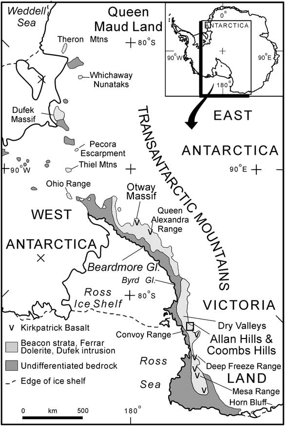
Devonian–Triassic Beacon Supergroup strata crop out along the length of the Transantarctic Mountains (Fig. 1) from north Victoria Land (NVL) to the Weddell Sea region (Collinson et al. Reference Collinson, Elliot, Isbell and Miller1994). The Permian to Triassic part of the Beacon, the Victoria Group, together with Jurassic sedimentary and overlying basaltic rocks, constitute the Gondwana sequence in Antarctica. It overlies Devonian strata of the Taylor Group on the pre-Permian Maya erosion surface or pre-Devonian igneous and metamorphic basement on the merged Kukri (pre-Devonian)–Maya erosion surfaces. The most complete Permian to Jurassic section is exposed in the central Transantarctic Mountains (CTM). There, the Victoria Group begins with glacial beds overlain by postglacial shales that transition through deltaic strata into fluvial beds comprising non-carbonaceous and carbonaceous flood plain sedimentary rocks of late Permian and Triassic age. The uppermost Triassic unit (the Falla Formation) is overlain by a Jurassic silicic sedimentary and volcanic sequence, the Hanson Formation (Elliot Reference Elliot1996), which in turn is overlain by Ferrar extrusive rocks comprising pyroclastic rocks and the overlying flood lavas of the Kirkpatrick Basalt (Elliot & Fleming Reference Elliot and Fleming2008).
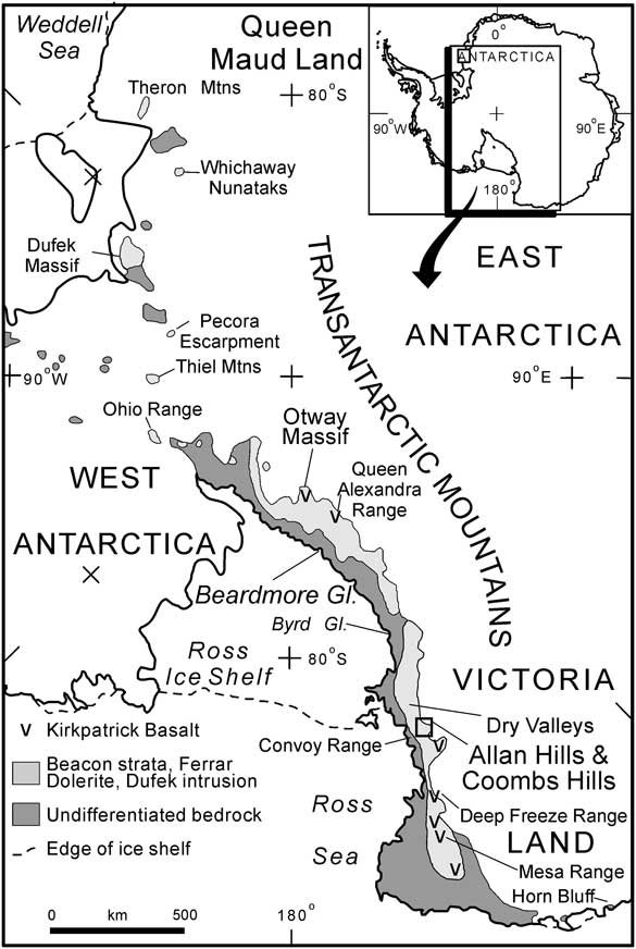
Location map for the Coombs Hills region, southern Victoria Land, Antarctica.
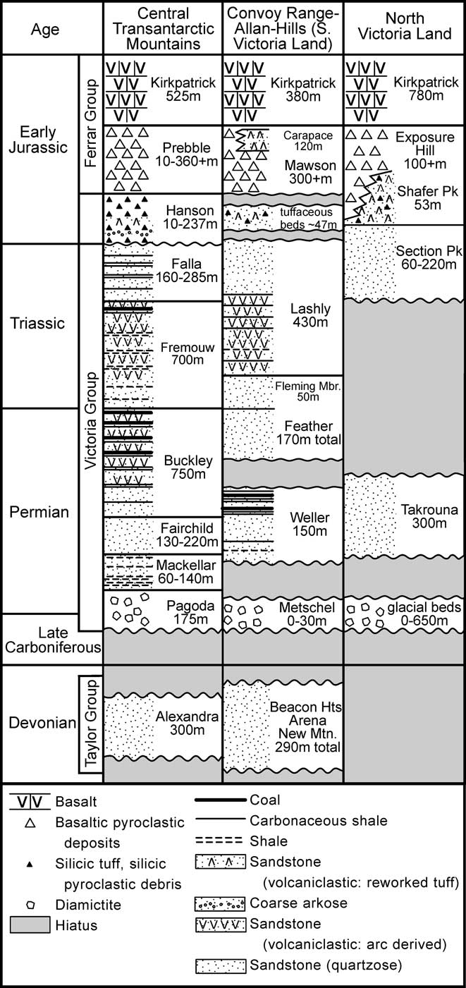
The Hanson Formation (CTM) is separated from the Falla Formation by a disconformity, which was inferred from field relationships (Elliot Reference Elliot1996). Recent work suggests, but does not prove, that the Hanson Formation is closely associated in time with the Ferrar magmatic rocks (Elliot et al. Reference Elliot, Fleming, Foland and Fanning2007), and thus the disconformity might span as much as 15 m.y. Silicic tuff clasts and sandstones with silicic ash occur in south Victoria Land (SVL) (Elliot et al. Reference Elliot, Fortner and Grimes2006). Although the sandstones appeared to be in stratigraphic continuity with the underlying Triassic Lashly Formation of SVL, the relationships to Ferrar pyroclastic rocks remained uncertain. In NVL, sandstones with silicic ash are interbedded with Ferrar pyroclastic rocks in the Deep Freeze Range and at the southern end of the Mesa Range, and overlie the Triassic–Jurassic Section Peak Formation (Schöner et al. Reference Schöner, Viereck-Goette, Schneider and Bomfleur2007).
This paper presents new information on the Triassic Lashly Formation at Coombs Hills (SVL) and the occurrence of silicic shard-bearing sandstones that are correlated with Jurassic strata (Grimes Reference Grimes2003), as well as the presence of phreatic explosion pipes cutting Lashly Formation beds. The shard-bearing sandstones are discussed in terms of the Jurassic geology of the Transantarctic Mountains (TAM) and the explosion pipes in terms of the emplacement of Ferrar magmas.
Regional geology in the Coombs Hills-Allan Hills
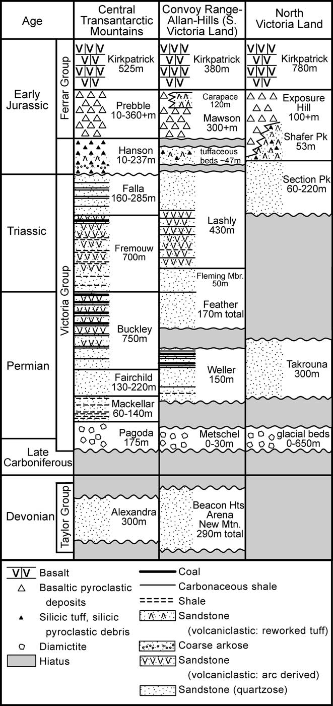
In SVL the basement consists of Neoproterozoic metamorphic rocks and Cambrian to lower Ordovician granitoids, deformed and emplaced, respectively, during the early Palaeozoic Ross Orogeny (Stump Reference Stump1995), although only the granitoids crop out in the Convoy Range (Fig. 1) 25 km to the east of Coombs Hills (Pocknall et al. Reference Pocknall, Chinn, Sykes and Skinner1994). The overlying Devonian Taylor Group in the Convoy Range consists of c. 290 m of quartzose strata (Fig. 2) although to the south in the McMurdo Dry Valleys region it is much thicker (c. 1400 m) and includes finer grained siliciclastic beds (Barrett Reference Barrett1991). The Devonian beds are overlain by a thin Permian glacial sequence that is succeeded by 75 m of Permian Weller Formation coal measures (Pocknall et al. Reference Pocknall, Chinn, Sykes and Skinner1994). At Allan Hills (Fig. 3), first described in detail by Ballance (Reference Ballance1977), 73 m of coal measures crop out (Collinson et al. Reference Collinson, Pennington and Kemp1983), but it is not known how much overlap occurs or how much section, if any, is missing. The overlying Triassic Feather Formation, a 173 m thick sandstone sequence, is succeeded by c. 325 m of the Lashly Formation. The Lashly Formation was divided into four informal members, corresponding to the subdivisions recognized 75 km to the south at Mount Bastion (Barrett & Webb Reference Barrett and Webb1973, Barrett & Kohn Reference Barrett and Kohn1975). At Allan Hills Lashly Formation member A (49 m thick) consists of volcaniclastic sandstone, siltstone, and mudstone with abundant paleosols characterized by root horizons. Member B (54 m thick) is a massive volcaniclastic sandstone with fossil logs. Member C (137 m thick) consists of volcaniclastic sandstone, carbonaceous siltstone and shale, which carry the Dicroidium flora, and minor thin coals. Member D (85 m thick, although the upper contact is not present) is a quartzose sandstone, carbonaceous siltstone and shale unit, which also includes the Dicroidium flora (Collinson et al. Reference Collinson, Pennington and Kemp1983). At Mount Bastion, Lashly Formation member D, which lacks an upper contact, has a minimum thickness of 210 m (Barrett & Webb Reference Barrett and Webb1973). Lashly Formation members C and D are late Triassic in age, based on palynomorhps (Kyle Reference Kyle1977, Kyle & Schopf Reference Kyle and Schopf1982). The depositional environment of Lashly Formation member C is interpreted to be a meandering stream setting, whereas for member D there are too few data for an interpretation (Collinson et al. Reference Collinson, Elliot, Isbell and Miller1994). Although the Lashly Formation crops out at Coombs Hills (Grapes et al. Reference Grapes, Reid and McPherson1974), stratigraphic and sedimentological information is lacking, and no plant material has been recorded.
Stratigraphic columns for Beacon Supergroup strata in the Queen Alexandra Range, Allan Hills-Coombs Hills-Convoy Range region, and north Victoria Land (Fig. 1).
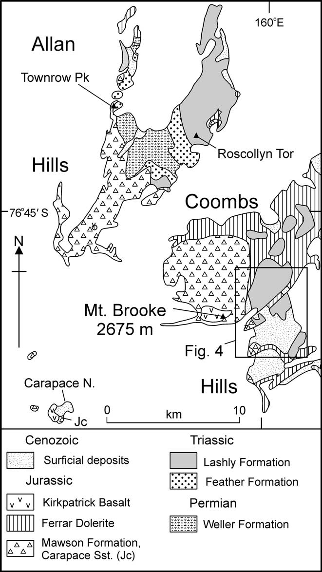
Geological sketch map of Allan Hills and Coombs Hills. Geology from Grapes et al. (Reference Grapes, Reid and McPherson1974), field observations, and aerial photography interpretation.
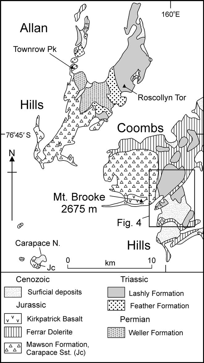
The relationship between Ferrar rocks and older strata at Coombs Hills and Allan Hills is complicated. At Coombs Hills, Mawson Formation pyroclastic rocks have cross-cutting contacts with the Lashly Formation and were interpreted as a ‘phreatocauldron’ (White & McClintock Reference White and McClintock2001), although Elliot et al. (Reference Elliot, Fortner and Grimes2006) illustrated an apparent stratigraphic contact. On Allan Hills, Mawson Formation rocks have been interpreted to overlie a major erosion surface with 500 m of relief (Ballance & Watters Reference Ballance and Watters1971, Ross et al. Reference Ross, White and McClintock2008), but evidence has been presented of a cross-cutting relationship (Elliot et al. Reference Elliot, Fortner and Grimes2006). Cross-cutting bodies consisting of basaltic pyroclastic debris together with Beacon clasts and sand grains are present at Allan Hills, and at Coombs Hills phreatic explosion pipes cut Lashly Formation beds. Kirkpatrick Basalt lavas overlie the Mawson Formation at Coombs Hills and at Carapace Nunatak (Elliot & Fleming Reference Elliot and Fleming2008).
Ferrar dolerite intrusive bodies are ubiquitous on Coombs Hills (Grapes et al. Reference Grapes, Reid and McPherson1974, White et al. Reference White, Bryan, Ross, Self and Thordarson2009). Dykes are thin and irregular, and lack any preferred orientation. More massive dykes occur within the Mawson Formation and along its contacts. Along the northern margin of Coombs Hills there are massive dolerite intrusions. Sills cutting the Lashly Formation are common, and locally in member D beds there are pods of dolerite.
Lashly Formation at Coombs Hills
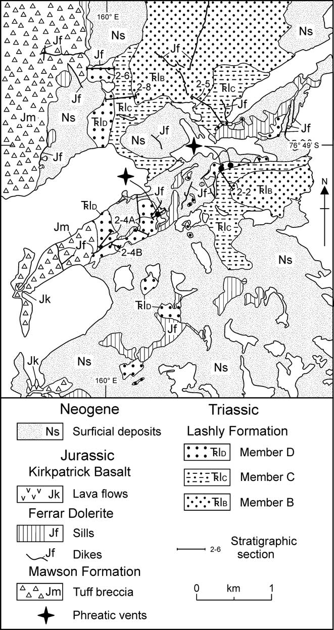
Grapes et al. (Reference Grapes, Reid and McPherson1974, fig. 1) illustrated the general distribution of the Lashly Formation at Coombs Hills, but did not discuss the stratigraphy. The study reported here was confined to a limited area east of Mount Brooke where the informal members B, C and D of Barrett & Kohn (Reference Barrett and Kohn1975) were recognized (Fig. 4). Member B forms extensive sandstone platforms in the northern and eastern parts of the map area. North and north-east of the mapped area (Fig. 3), Lashly Formation beds are present but were not examined and which members are present is not known. Bedded Lashly Formation also occurs as megaclasts in Mawson Formation breccias, as noted by White & McClintock (Reference White and McClintock2001), and was involved in peperite formation resulting from interactions between coal and magma, as described in detail by McClintock & White (Reference McClintock and White2002). The megaclast with coal peperite, described by McClintock & White (Reference McClintock and White2002), is part of member C.
Geological map of the area east of Mount Brooke, Coombs Hills. Geology from field observations and aerial photography interpretation.
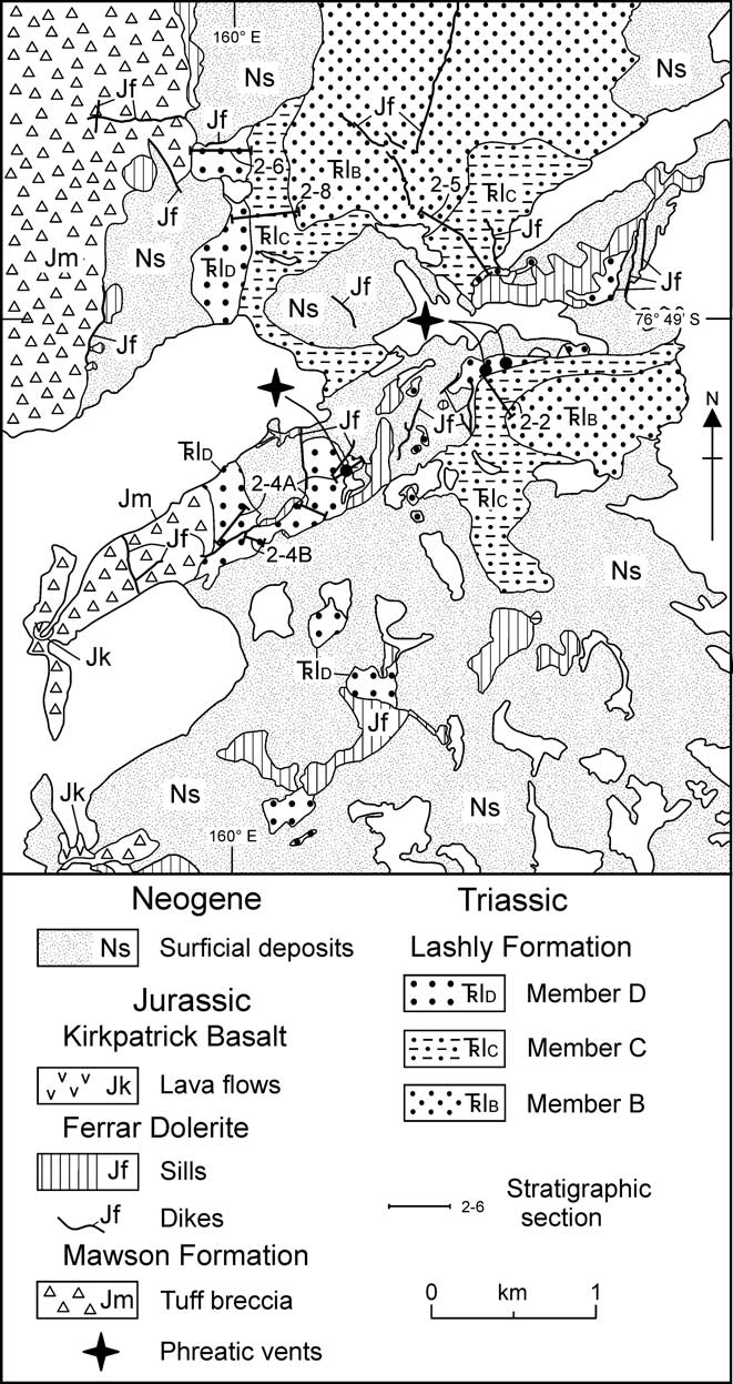
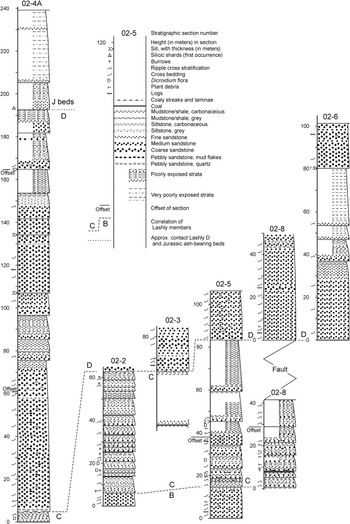
Lashly Formation strata commonly have a low dip, and attitudes vary from one locality to the next. Dips range up to c. 25° and lie between north-west and south-west. The variable attitudes probably result from Ferrar phreatomagmatism and dolerite emplacement. Stratigraphic columns are presented in Fig. 5.
Stratigraphic columns for Lashly Formation and Jurassic sedimentary strata. See Fig. 4 for locations of sections and text for the contact between Lashly Formation member D and the overlying ash-bearing beds of probable Early Jurassic age.

Member B
In the map area, only the uppermost part of Lashly Formation member B is exposed and consists predominantly of sandstones that form extensive platforms. A stratigraphic thickness of 14 m was measured at section 2-05 (for locations of sections see Fig. 4 and for stratigraphic columns see Fig. 5). The sandstones are massive, light grey to yellowish orange, medium-grained and quartzose. Trough cross bedding is well developed and consists of sets 20–50 cm thick, and smaller scale ripple-drift cross lamination is also present. Fragments of wood are common. Small pustular bodies < 1 cm in diameter are sparsely distributed.
Member C
The base of member C is marked by the lowest occurrence of carbonaceous debris and a change to cyclic sedimentation. It is 45–65 m thick at the two complete sections. The difference is due, at least in part, to variations in attitude and measurement up low slopes. The thickness at section 02-8 is a minimum because the contact with member D is faulted.
Member C consists of fining upwards cycles of medium to fine-grained volcaniclastic sandstones, many of which are micaceous, grey siltstones and grey to greenish-grey mudstones with varying amounts of carbonaceous material, and coal. Cycles commonly range from 2–6 m in thickness, but with a maximum of 11 m. The base of a cycle is a sandstone ledge, commonly < 1.5 m thick and filling slight scours in the underlying beds. Ripple cross lamination and small-scale trough cross bedding are common, with sets between 5 and 30 cm. The basal sandstones grade up into siltstones and mudstones. Carbonaceous material is more abundant upwards. Grey mudstones are increasingly dark, and pass into coaly mudstones and in many instances into coal. Coal beds range in thickness from 2–80 cm, but most are < 10 cm. Horizons with abundant plant macrofossils are present below many coal beds. Leaves of the Dicroidium flora are abundant. Other plant fossils and fossil logs also occur. Well preserved vertical burrows are present in some mudstones. One burrow has a diameter of 2 cm and a length of 35 cm, but most are thinner and < 10 cm long.
Sandstones contain ferruginous concretions and small pustular bodies. The concretions are < 7 mm in diameter and consist mostly of fine-grained pyrite with an oxidized outer rim. A zone of concentrated concretions occurs at 30 m above the base of the member at section 02-2. The pustular bodies, which consist of zeolite, stand out in outcrop due to slightly greater resistance to weathering than the host sandstone. The pustules are spherical and 0.5–1.5 cm in diameter. They occur either individually scattered or concentrated in zones.
Member D
Member D is principally a cyclic quartzose sandstone sequence, and the base is commonly marked by an intraformational breccia with angular mud clasts. Emplacement of dolerite dykes and sills, together with eruptive activity associated with generation of the Mawson Formation phreatocauldron, have disturbed the strata and caused tilting. The member has a measured thickness of 193 m, but all the measured sections are incomplete or poorly exposed. Further, although section 02-4A has the greatest stratigraphic thickness, it is a composite section with uncertainties in measurement, in particular in the very poorly exposed upper part, above the second offset at c. 165 m. Section 02-4B was measured to alleviate some of the uncertainties in that part. A unit with grey-white mudstones was used as the basis for correlation across the dyke that separates sections 02-4A and 4B, but it cannot be tied with confidence to section 02-4A and there are significant differences in the lithological succession. For these reasons it is not included in Fig. 5. The stratigraphically highest beds were examined (but not measured) to the south and west of the top of sections 02-4A and 4B. These form a sequence of sandstones and finer grained beds, which include silicic shard-bearing beds near the top of that exposure.
Section 02-4A terminates against a dyke, which separates Mawson Formation pyroclastic rocks from the sedimentary sequence. The contact, where the dyke is absent, is illustrated in Elliot et al. (Reference Elliot, Fortner and Grimes2006, figure 6.1-10). The poorly exposed section 02-4A terminates at that contact, and just out of view in that illustration. The top of section 02-8 passes into a very poorly exposed dip slope, which includes finer grained beds that abut the Mawson Formation. Just to the south of section 02-6, the uppermost coarse sandstones appear to be overlain stratigraphically by Mawson Formation pyroclastic rocks (Elliot et al. Reference Elliot, Fortner and Grimes2006, figure 6.1-8). The uppermost beds there and at the top of section 02-6 (the cliff immediately above the boxed fig. 9 in figure 6.1-8 of Elliot et al. Reference Elliot, Fortner and Grimes2006) are disturbed, showing irregular wavy bedding and abundant pustular zeolitic concretions. At the top of section 02-6 the quartzose sandstones are overlain by a contact zone, as much as 11 m thick, of irregular layers and blocks of sandstone, and bodies and layers of mixed sand and pyroclastic particles (Elliot et al. Reference Elliot, Fortner and Grimes2006, figure 6.1-9).
Member D comprises light grey to yellowish orange, coarse to medium grained sandstone with minor siltstone and grey mudstone, the latter with carbonaceous debris. Locally, massive bluffs and steep slopes of sandstone up to 56 m thick form the lower part of the member. Elsewhere the cycles average c. 10 m in thickness. Coarse sandstone grades up into medium to fine sandstone, forming ledges 30 cm to 6 m thick. Plant debris includes logs, stems and rare leaf fragments of the Dicroidium flora. The upper part of member D is also cyclic, although poorly exposed, with fine sandstone, siltstone and mudstone more common.
Pustular concretions of zeolite, similar to those in member C, are present in poorly to unstratified sandstone at the top of section 02-6. The pustules are either spherical and < 1.5 cm in diameter or form small tabular bodies up to 2.5 cm long.
Petrology
The member B sandstones examined microscopically have quartz, lesser amounts of lithic fragments, minor feldspar and accessory micas. Quartz, sub-angular to sub-rounded, is commonly undulose and contains inclusions. Feldspar includes plagioclase (An29) and subordinate microcline. Both muscovite and biotite are present, commonly deformed by compaction. Heavy minerals include sparse garnet, amphibole, zircon and opaque grains. Lithic grains are predominantly volcanic rock fragments, with trace amounts of metamorphic and sedimentary rock fragments. Volcanic fragments are microcrystalline to fine-grained aggregates of quartz and feldspar, with sparse quartz and plagioclase microphenocrysts. Feldspar-rich grains with trachytic textures form a trace component. Some quartz exhibits overgrowths and the matrix consists of phyllosilicates and secondary laumontite, which has also replaced feldspars and volcanic rock fragments. Carbonaceous matter occurs sparsely.
Member C sandstones are predominantly litharenites with sub-equal amounts of quartz and lithic fragments. Grains are sub-rounded to sub-angular, and moderately well sorted. Quartz, mainly with undulose extinction, has some inclusions and some grains show sutured margins. Minor feldspars include plagioclase (oligoclase) and a trace of K-feldspar. Micas, muscovite and biotite that is commonly bleached, are common in most samples. In some sandstones, micas form distinctive bands of aligned and elongate grains. Heavy minerals, although very sparse, include opaques, zircon, garnet, amphibole, and tourmaline. Volcanic rock fragments, commonly strongly altered, are predominantly microcrystalline with some showing trachytic textures and rarely quartz microphenocrysts. The rare metamorphic rock fragments are fine-grained and schistose. The matrix is dominated by phyllosilicates but carbonate occurs sporadically and laumontite is also present occasionally and forms the pustular bodies noted earlier. The matrix contains abundant fine-grained carbonaceous debris.
Member D sandstones are quartz-rich, ranging between quartz arenites and feldspathic arenites. In section 02-4 the sandstones are coarse-grained and grains are rounded to sub-rounded. Quartz grains are undulose, but individually they range from weak single grain undulose extinction, through multiple sub-grains with irregular boundaries or lamellar texture, to polycrystalline but lacking the fine grain size and fabric of a metamorphic rock. Needle-like inclusions are ubiquitous. Feldspars are subordinate and K-feldspar, which includes microcline and perthite, commonly exceeds plagioclase of oligoclase composition. Minor to trace amounts of micas, mainly biotite, are present. Lithic fragments are uncommon to sparse, and include volcanic, metamorphic and sedimentary clasts. Garnet is abundant, and is accompanied by traces of zircon, hornblende, and opaques. Carbonaceous debris is common in some sandstones. The composition of the cements forming the matrix is quite variable and includes carbonate, phyllosilicate and minor laumontite.
In other stratigraphic sections, the member D sandstones are medium grained, with sub-rounded to sub-angular grains, and are more feldspathic with plagioclase exceeding K-feldspar. In addition, lithic fragments, particularly fine-grained volcanic clasts, are more common but do not approach the abundance found in member C sandstones. Heavy minerals include garnet, and minor zircon, amphibole and opaque grains. The upper part of section 02-6 is characterized by abundant laumontite that forms large grain-enveloping plates. Where carbonate is the cement, there is much grain replacement.
Breccia pipes
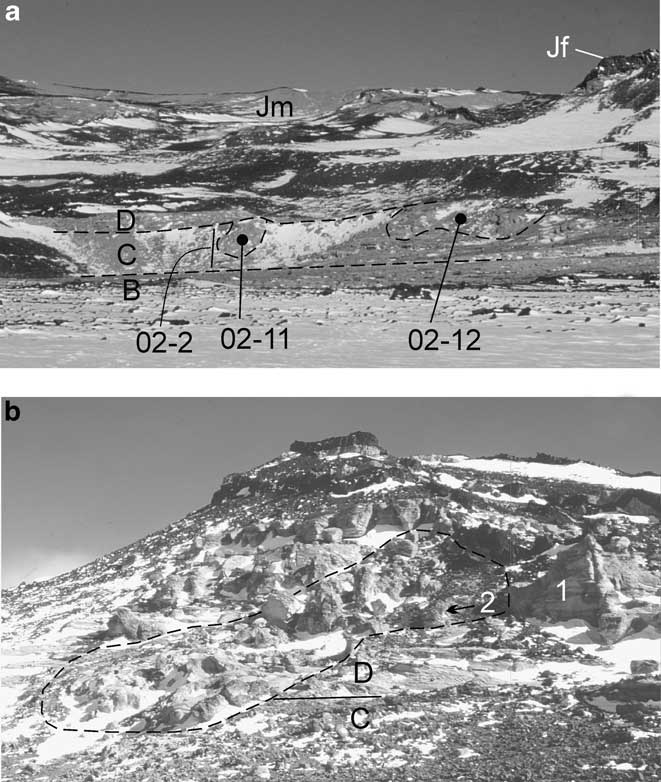
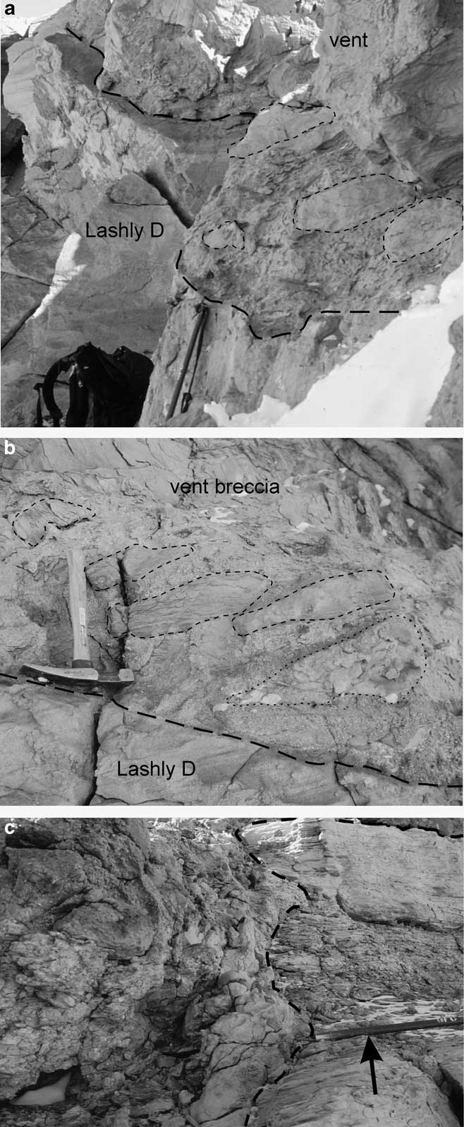
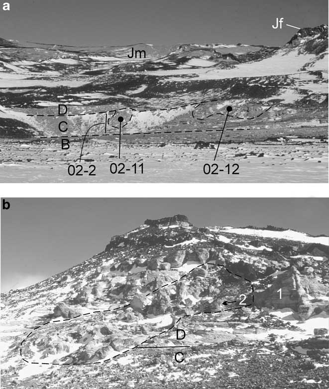
Two breccia pipes cut Lashly Formation member C beds at and near section 02-2 (Fig. 6a), and a third cuts member D beds at section 02-4A (Fig. 6b). The western pipe cutting member C (Fig. 6a, location 02-11) is exposed over a vertical interval of c. 24 m and, where it intersects a horizontal exposure of member D sandstone, has an areal extent of 14 x 7 m. The pipe consists of clasts, up to 2 m long, of carbonaceous shale and sandstone, fine-grained grey-green sandstone, and coarse quartz-rich sandstone. All clasts appear to be similar to member C except for the coarse sandstone that is probably from older Lashly Formation beds. Clasts are set in a sand matrix that includes scattered quartz pebbles up to 1 cm long, which also must have been derived from older Lashly Formation beds. Contacts are locally sharp but normally ill defined, with the adjacent country rock tilted and exhibiting loss of bedding and disaggregation. Contacts are exposed on the west side of the pipe (Fig. 7a & b) and have a range of attitudes that increases to vertical. The east side is snow covered.
a. Lashly Formation member C (section 02-2) cut by two phreatic explosion vents (locations 02-11 and 02-12). Letters B, C, and D indicate Lashly Formation informal members. View to north-west, with Mawson Formation (Jm) on the skyline. Jf = Ferrar Dolerite sill. b. Breccia pipe cutting Lashly Formation member D strata at section 02-4. Pipe outlined by dashed line. Lowest segment of section 02-4 measured adjacent to pipe. Boundary between members C and D indicated by solid line and adjacent letters. 1= north wall of pipe, illustrated in Fig. 8a. 2 = arrow indicating location of Fig. 8b.
a. Contact (heavy long dash lines) between Lashly Formation member D strata and the breccia pipe at location 02-11. Contact lies at the head of the ice axe. Several clasts are outlined by short dash lines. b. Close up of the contact (heavy long dash line) between Lashly Formation member D and breccia pipe (close to the ice axe in Fig. 7a). Short dash lines outline clasts except for that at lower right which is a pocket of centimetre size clasts. Hammer for scale. c. Member C clast with darker, fine-grained, thin bedded carbonaceous interval in centre (above ice axe, right side of image) within matrix of sand grains and quartz pebbles with centimetre size randomly oriented sedimentary clasts (left side of image) at location 02-12. Ice axe for scale (arrow).
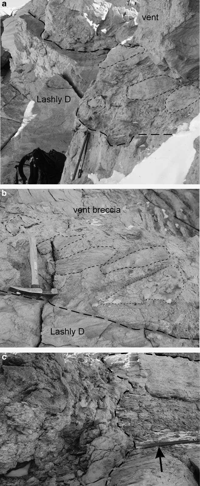
The eastern pipe (Fig. 6a, location 02-12) has a horizontal east–west extent of c. 180 m and a vertical exposure of > 20 m. Clasts and matrix in the pipe (Fig. 7c) are very similar to that described for the western pipe (location 02-11). In addition, megaclasts of sedimentary rock similar to Lashly Formation beds, rotated and slightly tilted, and with stratigraphic thicknesses up to 20 m, occur in this pipe. Slickenlines occur on many clasts. The sand matrix to the clasts may include quartz pebbles up to several centimetres. Where contacts are exposed they are irregular and not sharply delineated. At the lowest outcrop of pipe breccia, there is an exposed transition over c. 2 m from pipe breccia into stratified rock, with the coherence and stratification increasing away from the contact. The Lashly Formation member C country rock dips northward at c. 10° and the beds farther east have a similar low northerly dip and may also, from aerial photography interpretation, be cut by other breccia pipes.
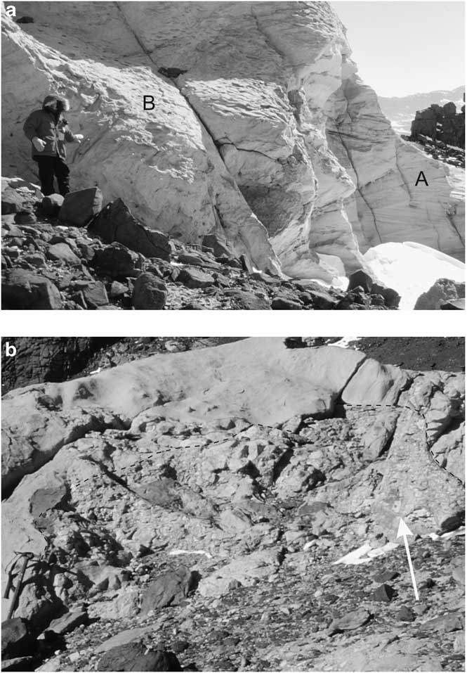
The pipe at section 02-4A (Fig. 6b), in outcrop, cuts the uppermost few metres of Lashly Formation member C and the lower part of member D. It is exposed over a vertical interval of c. 40 m and has a maximum horizontal width of c. 30 m. In plan view the form is somewhat irregular. On the north flank (right side in Fig. 6b) the Lashly Formation beds lose stratification within a few metres of the pipe (Fig. 8a). Locally the contact is well exposed and sharp, and steeply inclined to vertical. The pipe itself consists of blocks, ranging up to several metres long, of carbonaceous shale, white to greenish mudstone, grey fine-grained carbonaceous sandstone, greenish sandstone, and grey coarse-grained quartz arenite, all in a medium- to coarse-grained sand matrix (Fig. 8b). The coarse-grained quartz arenite is similar to basal beds of member D and the other clasts are similar to member C beds.
a. North margin of breccia pipe at section 02-4A (see Fig. 6b). Well stratified and cross bedded sandstones (A) pass horizontally into almost structureless sandstone in rock wall behind figure (B). Carbonaceous and wood clasts, up to 0.5 m long, occur in the outcrop to the right of the figure. b. Brecciated sandstone (dash outline) adjacent to, and partially derived from, an intact sandstone block within south side of the breccia pipe at section 02-4 (see Fig. 6b). Clasts include white angular mudstone (white arrow at right), greenish sandstone and white quartzose sandstone. Ice axe at lower left for scale.

Clasts in the breccia pipes include many that are carbonaceous, which suggests derivation from nearby member C beds or possibly from the Weller Formation at much greater depth (> 250 m stratigraphically below). Given the occurrence of shattered country rock at the pipe margins and the lack of a sharply delineated contact in many places, member C is a much more probable source. Further, it is unlikely that ‘shattered’ but intact megaclasts could have survived transport from any great depth. The shattering and disaggregation of the strata must result from violent explosions and hence, because basalt pyroclasts have not been observed, all three pipes are interpreted to result from phreatic explosions caused by emplacement of dolerite sills into underlying aquifers.
Sedimentary dyke
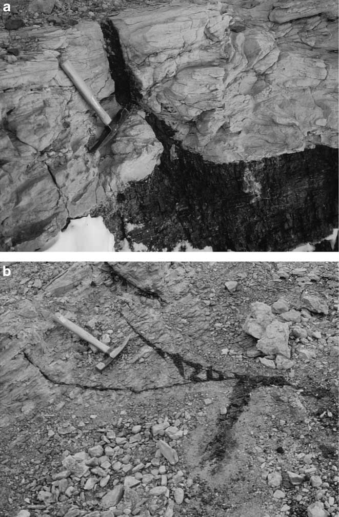
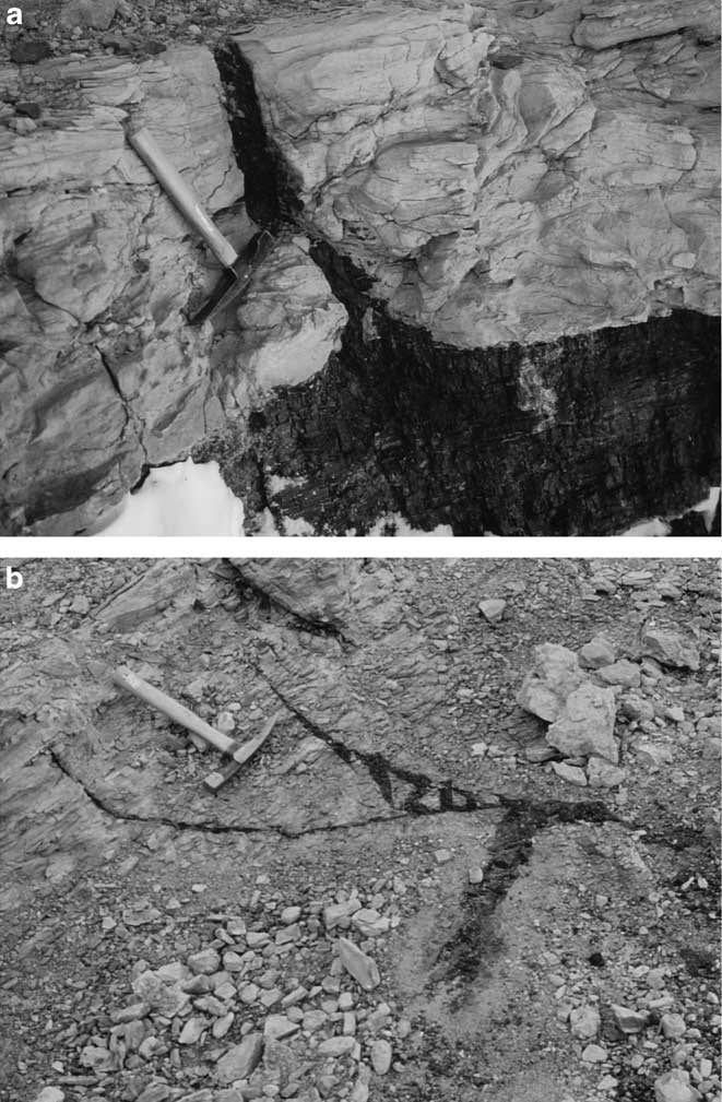
At section 02-2 thin dykes of coal originate from coal seams and penetrate overlying beds (Fig. 9a) and near the eastern end of location 02-12 form a small array (Fig. 9b). Thin sandstone dykes cut strata in the vicinity of locations 02-11 and 02-12. These dykes, mainly < 10 cm wide, originate in the pipes, or occur in strata close to the pipes, or within the pipes themselves. They have random orientation and may cross-cut each other. The sand in these dykes is poorly sorted with grains ranging up to coarse sand. The grains are angular to sub-rounded, mainly of quartz, together with small mudstone clasts and in some instances abundant carbonaceous particles in the grain interstices. Microscopically they are similar to the sand matrix that encloses the sedimentary clasts in the breccia pipes.
a. Coal dyke rising from a coal seam in Lashly Formation member C. Adjacent to section 02-2. Note the bedding in the coal, the irregular contact between coal and sandstone at the lower right hand side of the coal dyke, and the broken beds immediately above the coal bed. Hammer for scale. b. Coal dyke array cutting disturbed member C strata. The coal dykes must have originated from an adjacent underlying coal bed. Adjacent to location 02-12. Hammer for scale.
Basalt-coal interactions
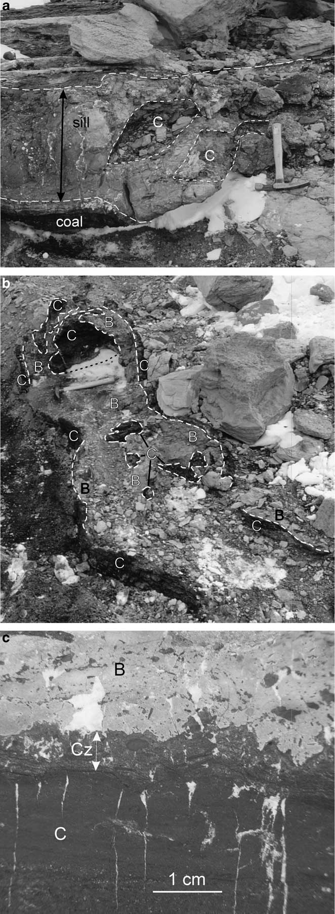
Basalt intrusions, 30–40 cm thick, occur in Lashly Formation member C beds c. 10 m below the western phreatic explosion pipe (location 02-11). These thin intrusions, parallel to and cross-cutting bedding, interacted with thin coal seams, either enclosing coal clasts or fragmenting into tuff breccia which encloses coal clasts (Fig. 10a). Locally the products of basalt-coal interaction form dyke-like bodies (Fig. 10b) with irregular and interfingering contacts. The contact (Fig. 10c) is crenulated and shows both basalt penetrating the coal and enclosing coal fragments, and basalt clasts, some angular but none with unequivocal quench form, enclosed in the vesicular contact zone of the coal. Microscopically, numerous small rounded calcite-filled ‘vesicles’, presumably cavities produced by devolatilization, occur in the coal and in coal fragments within the very fine-grained microporphyritic basalt. A few coal clasts enclose small (< 0.1 mm) globules of altered basalt which is similar to the highly altered host basalt at the contact. These are interpreted as globules of basalt magma incorporated into the coal fragments. Coal clasts, which are angular to sub-rounded, may show replacement, at least in part, by carbonate or phyllosilicate. Coarser calcite-filled veins cut the coal and basalt.
a. Basalt sill interacting with a coal bed and fragmenting into a “peperite”. Coal and basalt clasts (C) enclosed in highly altered basalt. Small blocks above the hammer consist of clasts of the basalt sill margin and coal clasts. Adjacent and below location 02-11. b. Basalt (B) interacting with coal (C) and forming a coal-peperite dyke. The dyke cross cuts sandstones. Adjacent and below location 02-11. Hammer for scale. c. Crenulated contact between basalt and coal. B = basalt, C = coal, Cz = contact zone in which coal contains numerous sub-millimetre calcite-filled vesicles; white veins and areas are calcite. Coal clasts enclosed in basalt range from non-vesicular (black) to vesicular (dark grey) and from angular to rounded and crenulated. From locality illustrated in Fig. 10b.

Dolerite intrusions
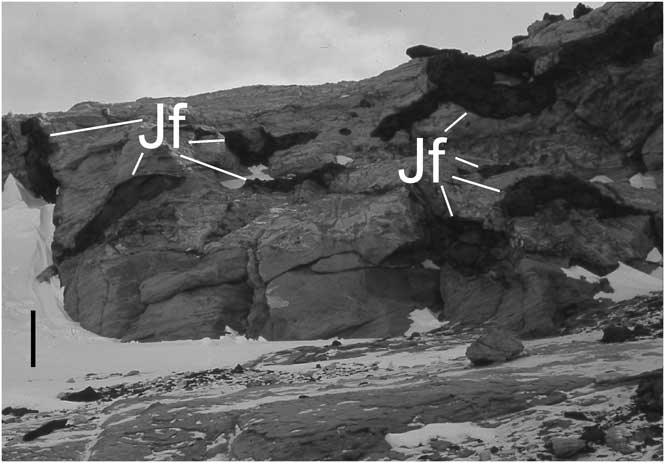
Sills, dykes and small intrusive masses emplaced into Lashly Formation strata are common. Several thin dolerite dykes intrude member D sandstones at sections 02-4A, 4B, and 6. The dykes are < 1 to 7.5 m thick, and form discordant bodies traceable for tens of metres. At section 02-4A discontinuous pods < 2 m long occur within poorly stratified sandstones (Fig. 11). Sandstones adjacent to the dykes and pods commonly exhibit poor stratification or are unstratified, in contrast to the typically well-stratified member D beds. The pustular (laumontite) concretions (up to 3 cm across) observed in other member B, C and D sandstones become notably abundant in sandstones adjacent to the dolerite intrusions.
Dolerite pods intruded into Lashly Formation member D strata. Bar scale on snow is c. 1 m. Adjacent to section 02-4A and near the 140–145 m level.

Jurassic strata
The upper, poorly exposed 47 m of section 02-4A includes finer grained sandstones, silicic ash-bearing beds, and tuffs. These beds form a distinct but not well-defined unit overlying the quartzose sandstones. Because of poor exposure, the transition from Lashly Formation member D to this unit may lie lower in the sequence in section 02-4A than the first occurrence of silicic shards, which is taken as the base of the Jurassic beds. At the contact of section 02-4A with the Mawson Formation, there are disconnected outcrops of sandstone, tuff, and rocks that were formed as a result of mixing of Mawson Formation pyroclasts and Lashly Formation sandstones during emplacement of the Mawson Formation tuff breccias. Similar lithologies occur along the contact to the south-west of sections 02-4A and 02-B, and are higher stratigraphically.
Sandstones in the upper 47 m of section 02-4A (and in section 02-4B) differ from Lashly Formation member D sandstones in the finer grain size and more abundant heavy minerals, which include garnet, green amphibole, zircon, tourmaline, kyanite and titanite. Biotite and muscovite are more common, and rare pumice fragments occur. Tuffaceous siltstones, with varying amounts of quartz and feldspar, are characterized by bubble wall shards, most of which are strongly altered. Thin shard-bearing tuff beds are also present.
Discussion
Stratigraphy
Lashly Formation strata mapped to the east of Mount Brooke comprise the uppermost part of member B, member C and member D. Member D has a thickness of 193 m at section 02-4A, but the contact with the shard-bearing beds (in Fig. 5 placed immediately below the first occurrence of ash) is not well located and may occur lower in the section. The shard-bearing beds forming the uppermost part of section 02-4A are very poorly exposed. Observations on the south flank of the ridge on which it was measured also showed that the sandstone-dominated lower part of the Lashly Formation gives way to finer grained beds. On that south flank, the thick sandstones are followed by a slope of surficial debris until just below the contact with the Mawson Formation, where a small interval of poorly exposed green mudstones and white sandstones crop out. These sandstones contain silicic shards, as do sandstone clasts incorporated into the adjacent Mawson Formation tuff breccias. Adjacent to the top of section 02-4A there are small isolated outcrops of silicic tuff and shard-bearing fine sandstone. Such silicic ash has also been reported from the contact zone between the top of section 02-6 and the Mawson Formation (Elliot et al. Reference Elliot, Fortner and Grimes2006) and as silicic tuff clasts in Mawson Formation tuff breccia at Coombs Hills (Bradshaw Reference Bradshaw1987, McClintock Reference McClintock2001).
The Triassic Section Peak Formation (NVL) is dominated by quartzose sandstone but at Roberts Butte the upper few tens of metres contain silicic ash (Collinson et al. Reference Collinson, Pennington and Kemp1986, fig. 24) and other isolated outcrops of ash-bearing sandstones were noted in the region (Elliot et al. Reference Elliot, Haban and Siders1986). The occurrence and relationships of silicic ash-bearing strata in NVL have been clarified by Schöner et al. (Reference Schöner, Viereck-Goette, Schneider and Bomfleur2007). A new unit, the Shafer Peak Formation, has been established for the sequence of fine-grained tuffaceous sandstones and siltstones that occurs above the quartzose Section Peak Formation. The Shafer Peak Formation is locally interbedded with mafic pyroclastic deposits assigned to the ‘Exposure Hill Events’ (including the former Exposure Hill Formation). Plant remains suggest an Early Jurassic age for the Shafer Peak Formation (Schöner et al. Reference Schöner, Viereck-Goette, Schneider and Bomfleur2007). Further, detrital zircon geochronology indicates an Early Jurassic age for the Section Peak Formation at Section Peak itself (Goodge & Fanning Reference Goodge and Fanning2010). This raises the possibility that the upper part of Lashly Formation member D might also be Early Jurassic.
At Mount Bastion, the Lashly Formation is at least 210 m thick and is capped by a 100 m thick dolerite sill. Above the sill, Barrett & Webb (Reference Barrett and Webb1973) report a further 10 m of poorly exposed light greenish-grey fine sandstone and siltstone, which are here postulated to be equivalent to the Shafer Peak Formation. Although broken by dolerite intrusions, Lashly Formation member D at, and in the vicinity of, section 02-4A, passes upward from thick quartzose sandstones (c. 190 m thick) into a sequence of finer grained strata that include tuffaceous beds with silicic shards. The upper part of section 02-4A at Coombs Hills is separated out as a different stratigraphic unit, although not given a formal name because of uncertainties in the contact relationship. It is clearly the equivalent of the Shafer Peak Formation in NVL (Schöner et al. Reference Schöner, Viereck-Goette, Schneider and Bomfleur2007). Detailed stratigraphic studies on the south flank of the ridge on which section 02-4A was measured should reveal the transition from the quartzose member D into the shard-bearing section, the two units perhaps being separated by a disconformity.
In CTM the Hanson Formation also records Early Jurassic silicic volcanism (Elliot et al. Reference Elliot, Fleming, Foland and Fanning2007). The lower part includes tuffaceous sandstones, two siliciclastic (arkosic) units quite distinct from the quartzose sandstones of the underlying Triassic Falla Formation, and a tuff-tuffaceous sandstone interval, whereas the upper part is dominated by tuff. It is the equivalent of the Shafer Peak Formation.
The occurrence of clasts of silicic tuff associated with the Jurassic tuff breccias has been noted at Mount Weir, Deep Freeze Range (Elliot et al. Reference Elliot, Fleming, Foland and Fanning2007) and tuffs interbedded with tuff breccia at Mount Fazio, NVL, have a significant component of silicic ash (Elliot et al. Reference Elliot, Haban and Siders1986). Large silicic tuff clasts have also been reported from Coombs Hills (Bradshaw Reference Bradshaw1987, Elliot et al. Reference Elliot, Fortner and Grimes2006) and the Beardmore Glacier region (Elliot et al. Reference Elliot, Fleming, Foland and Fanning2007). As noted by Elliot et al. (Reference Elliot, Fleming, Foland and Fanning2007) and Schöner et al. (Reference Schöner, Viereck-Goette, Schneider and Bomfleur2007), a significant episode of principally distal silicic volcanism preceded and overlapped with emplacement of the Ferrar tholeiitic rocks. Silicic ash and Ferrar magmas were erupted into an inferred rift (Elliot & Larsen Reference Elliot and Larsen1993), which is best documented in CTM. Isotopic data for the ash, which is high silica rhyolite in composition, shows that the source was neither the Ross Orogen basement nor the contaminant for Ferrar magmas (Elliot et al. Reference Elliot, Fleming, Foland and Fanning2007). Hence the source was inferred to be either an unexposed TAM crustal terrain that underwent anatectic melting associated with Ferrar magmatism or unexposed Early Jurassic magmatic centres in West Antarctica.
Ferrar magma interactions
Apart from the large-scale sills, dykes and intrusive bodies in the study area, less obvious features related to Ferrar magmatism are present. Examples include thin dolerite sills that pass into tuff breccia and peperite on magma-water (pore water) interaction, and are similar to that described at Shapeless Mountain, SVL, by Korsch (Reference Korsch1984). In situ disaggregation of sandstones in the vicinity of thin dykes and even disruption of the dykes themselves also reflects shallow intrusion of magma into water-rich sedimentary rocks. Particularly striking are those rocks that show interaction between basaltic magma and coal beds. The features formed here on basalt-coal interaction are somewhat similar to those reported by McClintock & White (Reference McClintock and White2002) who described megaclasts of Lashly Formation member C strata engulfed in Mawson Formation rocks. The scale of interaction, however, is much less as a result of the small-scale of the basalt intrusions involved in the process. Nevertheless, the member C coal was mobilized, which led to the formation of small basalt-coal intrusions exhibiting complex crenulated contacts between coal and basalt.
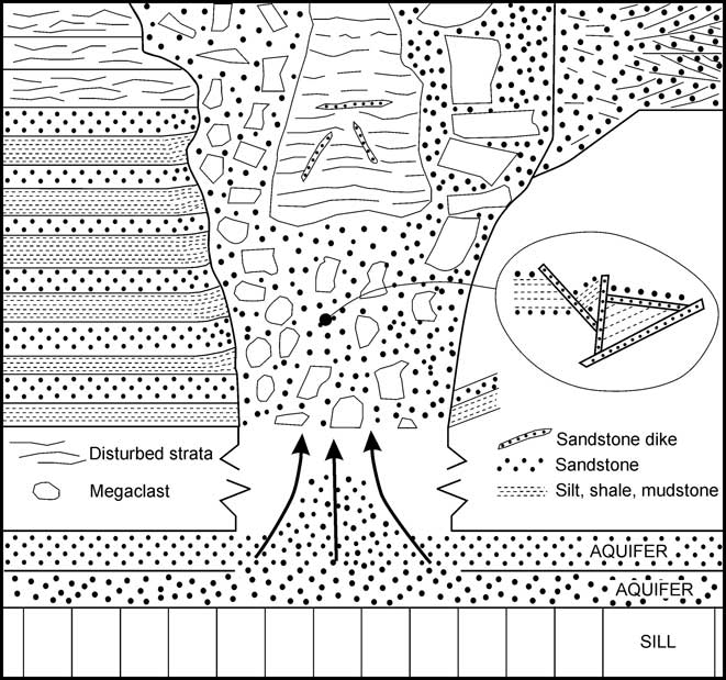
The breccia pipes cutting Lashly Formation strata are another example (Fig. 12). They are comparable with the sandstone pipes cutting Karoo strata in South Africa, which have been described as hydrothermal vents and attributed to phreatic explosions driven by emplacement of Karoo dolerite sills (Jamtveit et al. Reference Jamtveit, Svensen, Podladchikov and Planke2004, Svensen et al. Reference Svensen, Jamtveit, Planke and Chevallier2006, Reference Svensen, Planke, Chevallier, Malthe-Sørenssen, Corfu and Jamtveit2007). Similar hydrothermal vents associated with the end-Permian Siberian Traps have been documented by Svensen et al. (Reference Svensen, Planke, Polozov, Schmidbauer, Corfu, Podladchikov and Jamtveit2009), and have been inferred for seismically identified structures associated with the Palaeogene North Atlantic large igneous province off Norway (Jamtveit et al. Reference Jamtveit, Svensen, Podladchikov and Planke2004, Svensen et al. Reference Svensen, Planke, Malthe-Sørenssen, Jamtveit, Myklebust, Eidem and Rey2004).
Schematic illustration of the breccia pipes. Steam explosions, generated by sill emplacement into or adjacent to aquifers, cause disaggregation and fragmentation of aquifers and overlying strata.

Although on a much larger scale than those at Coombs Hills, a similar body of disaggregated sand and Beacon clasts occurs north of ‘Watters Peak’ on Allan Hills. This body has been attributed to basaltic magma emplacement at depth followed by collapse on magma withdrawal (Elliot et al. Reference Elliot, Fortner and Grimes2006) although alternatively, based on a more exhaustive investigation of the rocks regionally, it has been interpreted as a landslide deposit (Reubi et al. Reference Reubi, Ross and White2005). The breccia pipes cutting the Lashly Formation at Coombs Hills are attributed to Ferrar sill emplacement and accompanying explosive steam generation in Beacon aquifers, which caused fluidization and drove pipe-like columns of steam and particles upward. These explosions shattered the Beacon rocks, producing both discrete clasts with a great range of sizes and totally disaggregated sand which forms the matrix for the clasts. The resulting bodies have an irregular pipe-like form, clearly cross-cutting country rock strata. The steam explosions are also interpreted as the root cause for the occurrence of the shattered looking beds (but retaining their stratigraphic order) forming the upper 20 m of section 02-2, similar looking strata within and adjacent to the eastern margin of the pipe at location 02-12, and the lack of well-defined stratification in the Lashly Formation adjacent to thin dykes and pods of dolerite. The coal and sandstone dykes are also attributed to sill emplacement with the associated heating of pore fluids in the country rock, the fracturing thereof, and the formation of fluid escape structures (sandstone dykes) observed in the pipes and country rock. Grapes et al. (Reference Grapes, Reid and McPherson1974) described brecciated sedimentary rocks at Allan Hills that they attributed to phreatic explosions associated with dolerite intrusion. Zeolite (laumontite) and calcite observed microscopically are probably related to warm hydrothermal fluids associated with Ferrar magmatism, as noted by Ballance & Watters (Reference Ballance and Watters2002) for Permian and Triassic strata on Allan Hills.
Conclusions
Triassic strata east of Mount Brooke at Coombs Hills include Lashly Formation members B, C and D. Quartzose sandstones of member D are overlain by poorly exposed finer grained strata that include silicic shard-bearing beds. Although the exact stratigraphic relations between the quartzose strata and the silicic ash-bearing beds are uncertain, the latter are equivalent to the Lower Jurassic Shafer Peak Formation of NVL and the Hanson Formation of CTM. A disconformity may separate the quartzose and ash-bearing beds. Outcrops of members C and D are cut by breccia pipes resulting from emplacement of Ferrar magmas and consequent explosive generation of steam from groundwater. Sandstone and coal dykes also resulted from the inferred phreatic explosive activity, whereas phreatomagmatic activity is documented only by the small-scale examples of basalt-coal interaction.
Acknowledgements
This research was supported by the Office of Polar Programs, National Science Foundation grant OPP 0087919. Discussion of the stratigraphy with James Collinson and comments by James White on the breccia pipes and other features attributed to Ferrar magmatism are also greatly appreciated. Reviews by Teal Riley and Greg Retallack improved the manuscript.