INTRODUCTION
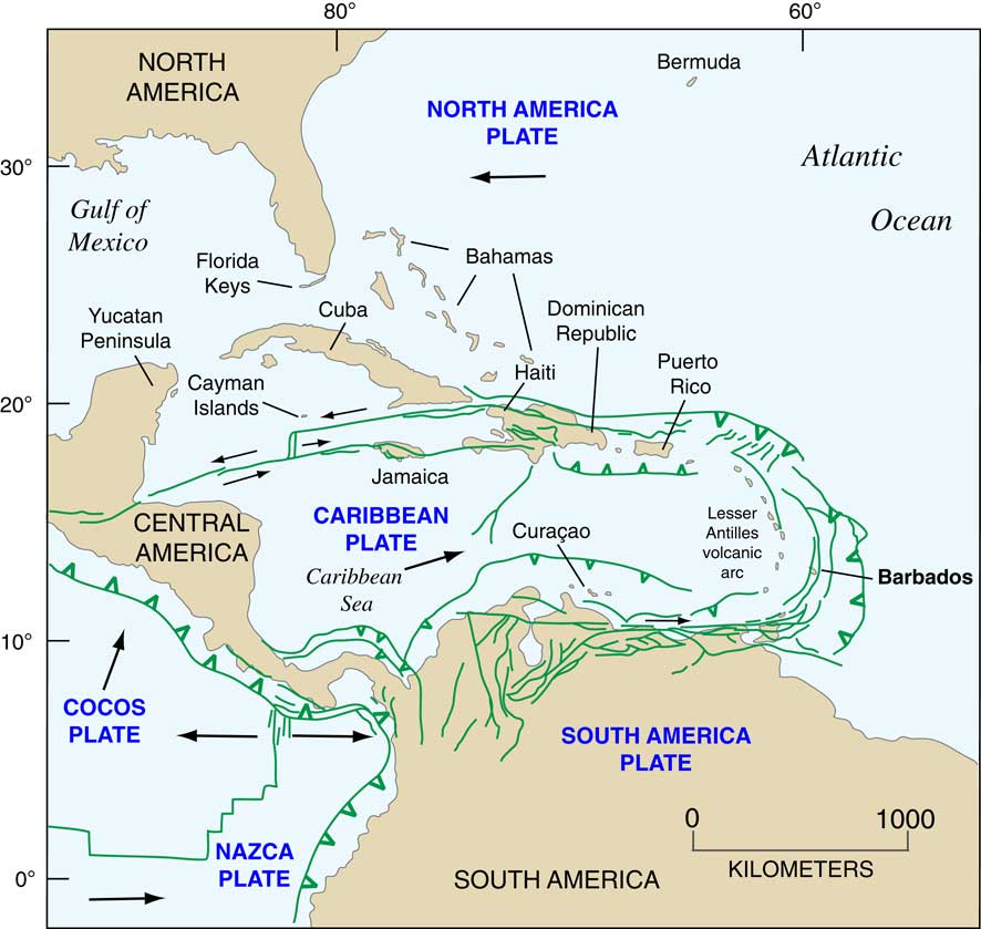
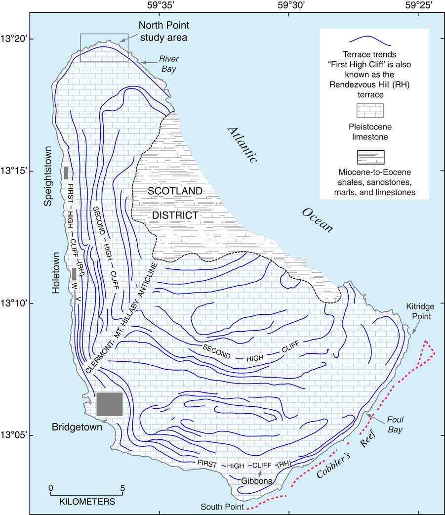
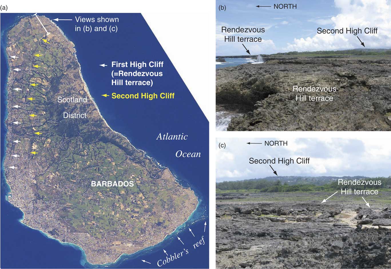
The island of Barbados, situated in the western Atlantic Ocean (Fig. 1), has been one of the most important locations in the world for providing geologic records of Quaternary sea-level history. Jukes-Brown and Harrison (Reference Jukes-Browne and Harrison1891) may have been among the first geologists to note the visually striking, multiple, uplifted coral-reef terraces on Barbados (Fig. 2 and 3). Numerous terraces have since been mapped on this island (Fig. 2) and two of them, originally called First High Cliff and Second High Cliff, are such prominent features that they can be seen easily from space (Fig. 3a). First High Cliff was later called “Barbados III” (Broecker et al., Reference Broecker, Thurber, Goddard, Ku, Matthews and Mesolella1968; Mesolella et al., Reference Mesolella, Matthews, Broecker and Thurber1969), as it is the third emergent terrace, and has been called the “Rendezvous Hill” terrace in the past few decades (Bender et al., Reference Bender, Fairbanks, Taylor, Matthews, Goddard and Broecker1979).
(color online) Tectonic map of the Caribbean Basin and surrounding areas, showing faults (redrawn from Mann [Reference Mann2007] and Pindell and Kennan [Reference Pindell and Kennan2009]), lithospheric plates, directions of present plate movements (arrows), and location of Barbados.

Map of Barbados, showing localities referred to in the text, extent of Tertiary rocks of the Scotland District, and trends of Pleistocene coral reef terraces. The two most prominent reef crests, First High Cliff and Second High Cliff, are labeled. First High Cliff is also known as the Rendezvous Hill (RH) terrace; younger terraces are the Ventnor (V) and Worthing (W) terraces. Also shown (small box) is the location of the present study area near North Point (Fig. 4a). Spatial extent of First High Cliff and Second High Cliff redrawn from Taylor and Mann (Reference Taylor and Mann1991); spatial extent of other terraces redrawn from Mesolella et al. (Reference Mesolella, Matthews, Broecker and Thurber1969). Distribution of Cobbler’s Reef (offshore, red dashed line) taken from Toscano (Reference Toscano2016). (For interpretation of the references to color in this figure legend, the reader is referred to the web version of this article.)

(color online) (a) Astronaut (handheld camera) photograph of Barbados taken from the International Space Station (image # ISS006-E-38027, acquired 13 March 2003, 13:05:03 GMT; altitude 394 km). Arrows point to cliffs of the most prominent terraces, First High Cliff (=Rendezvous Hill terrace) and Second High Cliff. Photo courtesy of NASA. (b and c) Ground photographs of the hypothesized Rendezvous Hill terrace and Second High Cliff, looking east from the northern coast of Barbados, taken by the authors (see [a] for location).

Beginning in the 1960s, Barbados terraces were the subject of detailed studies for the next five decades, starting with work on reef facies and geometry (Mesolella, Reference Mesolella1967; Mesolella et al., Reference Mesolella, Sealy and Matthews1970) and uranium-series (U-series) dating of corals from the youngest (lowest elevation) terraces, with linkage to the marine oxygen isotope record and orbital forcing (Broecker et al., Reference Broecker, Thurber, Goddard, Ku, Matthews and Mesolella1968; Ku, Reference Ku1968; Mesolella et al., Reference Mesolella, Matthews, Broecker and Thurber1969; James et al., Reference James, Mountjoy and Omura1971; Matthews, Reference Matthews1973). In southwestern Barbados, corals from Pleistocene reef-crest localities on the Worthing, Ventnor, and Rendezvous Hill terraces (Barbados I, II, and III of earlier studies) were dated to ~80 ka, ~105 ka, and ~125 ka, respectively (Broecker et al., Reference Broecker, Thurber, Goddard, Ku, Matthews and Mesolella1968; Mesolella et al., Reference Mesolella, Matthews, Broecker and Thurber1969). Thus, the lowest three terraces on Barbados can be correlated with Marine Isotope Substages (MIS) 5.1 (Worthing), 5.3 (Ventnor), and 5.5 (Rendezvous Hill), using the substage designations of Martinson et al. (Reference Martinson, Pisias, Hays, Imbrie, Moore and Shackleton1987).
Later work on Barbados initiated experimental dating of older, higher-elevation terraces by He-U and electron spin resonance (ESR) methods (Bender et al., Reference Bender, Taylor and Matthews1973, Reference Bender, Fairbanks, Taylor, Matthews, Goddard and Broecker1979; Radtke et al., Reference Radtke, Grün and Schwarcz1988). Barbados was also the island that became the natural laboratory for investigation of higher-precision U-series dating, using thermal ionization mass spectrometry (TIMS), by Edwards et al. (Reference Edwards, Chen, Ku and Wasserburg1987a, Reference Edwards, Chen and Wasserburg1987b). This new method of U-series analysis yielded similar, but much more precise ages of the Worthing, Ventnor, and Rendezvous Hill terraces dating to MIS 5.1, 5.3, and 5.5, respectively (Bard et al., Reference Bard, Hamelin and Fairbanks1990; Gallup et al., Reference Gallup, Edwards and Johnson1994, Reference Gallup, Cheng, Taylor and Edwards2002; Edwards et al., Reference Edwards, Cheng, Murrell and Goldstein1997; Cutler et al., Reference Cutler, Edwards, Taylor, Cheng, Adkins, Gallup, Cutler, Burr and Bloom2003). Still later studies led to proposals that the Barbados reef-terrace sequence had greater complexity than previously thought, with the possibility of suborbital variations in sea level being reported in some of this work (Blanchon and Eisenhauer, Reference Blanchon and Eisenhauer2001; Johnson, Reference Johnson2001; Potter et al., Reference Potter, Esat, Schellmann, Radtke, Lambeck and McCulloch2004; Schellmann and Radtke, Reference Schellmann and Radtke2004a, Reference Schellmann and Radtke2004b; Schellmann et al., Reference Schellmann, Radtke, Potter, Esat and McCulloch2004; Speed and Cheng, Reference Speed and Cheng2004; Thompson and Goldstein, Reference Thompson and Goldstein2005).
Critical factors to almost all of the Barbados studies cited above have been elevation measurements and dating of fossil specimens of coral, particularly the elkhorn coral, Acropora palmata. This Caribbean and western Atlantic coral has been found, at least until the past few decades (see the perspective by Kuffner and Toth, Reference Kuffner and Toth2016), in the eastern Caribbean region from southern Florida to Venezuela, in the western Caribbean from Belize to Colombia, and along most of the islands in between (Goreau, Reference Goreau1959; Chiappone et al., Reference Chiappone, Sullivan and Lott1996). Detailed studies of modern Jamaican reefs in a now-classic pair of papers by Goreau (Reference Goreau1959) and Goreau and Goreau (Reference Goreau and Goreau1973) show that, although A. palmata can be found in the back-reef zone close to shore, it is dominant farther offshore in the reef crest zone, within an upper (“breaker”) zone varying in width from 6–10 m and at depths of 0.5–3 m. It is also dominant in what Goreau (Reference Goreau1959) calls a lower reef crest zone that is found seaward of the breaker zone, varying in width from 30–50 m and at depths of 3–6 m. In the upper or breaker zone, A. palmata colonies are exposed to strong surf action from the open ocean. Goreau (Reference Goreau1959) notes that because of its exposure to open seas and strong wave action, A. palmata colonies are easily broken up and provide detrital fragments upon which other zones of the reef are built.
Because of its restricted depths, typically no more than ~6 m, A. palmata is particularly valuable as a paleo-sea-level indicator in fossil form if it can be found in growth position. As with all corals, A. palmata takes up U from seawater during growth, making U-series dating possible. Its robust character often preserves primary aragonite within the inner parts of the thick, dense branches of the colonies. Furthermore, it is the most common species found in fossil form in at least the lowest (youngest) emergent terraces of Barbados (Pandolfi and Jackson, Reference Pandolfi and Jackson2006). All these favorable characteristics make A. palmata a valuable species for determination of past sea levels when it is found in growth position within an emergent fossil reef. On Barbados, Mesolella (Reference Mesolella1967) showed that many of the emergent reef terraces have lateral facies changes in structure and dominant coral taxa, including A. palmata, that are very similar to the facies changes in modern coral reefs off Jamaica (Goreau, Reference Goreau1959).
Recovery of fossil corals such as Acropora palmata in growth position from emergent reef terraces is not always a straightforward process, however. Corals can be damaged by strong storms or hurricanes and this has been documented in historic time off western Barbados (Mah and Stearn, Reference Mah and Stearn1986). Macintyre et al. (Reference Macintyre, Glynn and Toscano2007a, Reference Macintyre, Glynn and Toscano2007b) report that an A. palmata-dominated reef off the southeastern coast of Barbados, Cobbler’s Reef (Fig. 2 and 3a), was damaged by a storm or storms at some time in the late Holocene. In addition to physical evidence for storm reworking, radiocarbon ages of A. palmata from Cobbler’s Reef presented by Macintyre et al. (Reference Macintyre, Glynn and Toscano2007a) show deviations from the age/depth relations that would be expected based on regional sea-level curves that have been generated for the western Atlantic Ocean. Elsewhere on Barbados, Blanchon and Eisenhauer (Reference Blanchon and Eisenhauer2001), Perry (Reference Perry2001), and Macintyre et al. (Reference Macintyre, Glynn and Toscano2007b) report evidence of storm reworking of A. palmata fragments onto emergent Pleistocene marine terraces.
With the possibility on Barbados that emergent, low-elevation terraces can host storm deposits rather than growth-position corals, it is important to determine the possible range of ages of reworked coral clasts. Interpretations about sea-level history could be erroneous if corals from an earlier high-sea stand were mixed by storm waves with corals from a later high-sea stand. If age assignments given to terraces are based on only a small number of coral analyses and without documentation of stratigraphic context (growth position vs. storm deposits), there will be uncertainty in a reconstructed sea-level history.
Because Barbados has figured so prominently in Quaternary sea-level studies, we wished to ascertain just what the range of ages of corals might be at a locality where a storm origin for deposits on marine terraces is well documented. On a marine terrace at River Bay, northern Barbados (Fig. 2), Perry (Reference Perry2001) recognized coral fragments in five depositional units that he interpreted as storm deposits. These five sequences host coral fragments that have upward-increasing thicknesses of encrusting organisms (coralline algae, serpulids, bryozoans, and foraminifera). The encrusting organisms colonized the clast surfaces after deposition but before terrace emergence. Not far from this locality, we concentrated our field efforts on deposits that have a similar sedimentology to those described by Perry (Reference Perry2001) and where coral ages within the sequence could be investigated (Fig. 4 and 5). Exposures along this reach of coastline have figured in previous publications (see Plate 3 in Mesolella et al. [Reference Mesolella, Matthews, Broecker and Thurber1969] and fig. 8.3 and 8.4 in Speed [Reference Speed2012]), but have received little study.
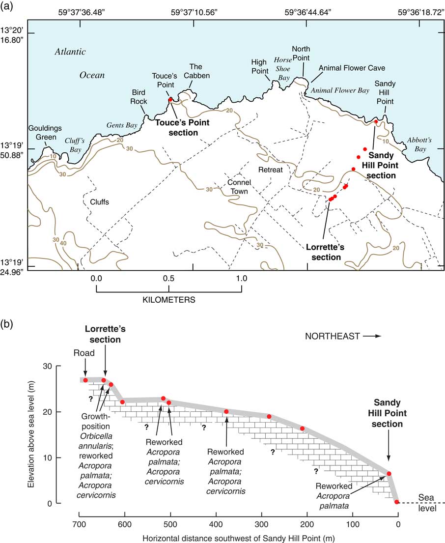
(a) Map of northern Barbados showing study localities. Red dots show localities where GPS elevation measurements were made for topographic profile shown in (b). Contour lines (interval=10 m) are redrawn from Government of Barbados, topographic map series (1986), sheet 1, scale 1:10,000, slightly modified in places where measurements from the present study are at variance with the generalized contours. Dashed black lines are roads. (b) Topographic profile from Lorrette’s section to Sandy Hill Point, showing elevations derived from differential GPS measurements; measurement points shown as red dots in (a). Also shown are the most common reef taxa found at each locality along the transect and their stratigraphic context. (For interpretation of the references to color in this figure legend, the reader is referred to the web version of this article.)

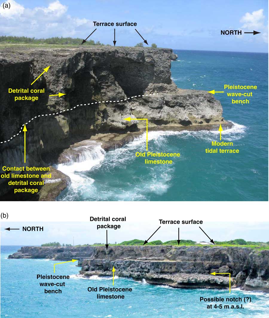
(color online) (a) Exposure of hypothesized Rendezvous Hill terrace (last interglacial age) and older, underlying Pleistocene limestone at Touce’s Point study area (see Fig. 4a for location), looking west. Note contact between younger and older limestone expressed as a distinct wave-cut bench exposed subaerially in the seaward extreme of the point. The same area appears as Plate 3 in Mesolella et al. (Reference Mesolella, Matthews, Broecker and Thurber1969) and as Figure 8.3 in Speed (Reference Speed2012). (b) Exposure of Rendezvous Hill terrace (last interglacial age) and older, underlying Pleistocene limestone, also near Touce’s Point study area (see Fig. 4a for location), but looking east. Note features as described in (a), but also possible notch at ~4–5 m asl, below wave-cut bench; another expression of this feature may be the cave/notch shown in Fig. 6b. Photographs by the authors.

PREVIOUS WORK IN THE STUDY AREA OF NORTHERN BARBADOS
Compared to southwestern Barbados, there have been relatively few studies of reef terraces on the northern part of the island. Broecker et al. (Reference Broecker, Thurber, Goddard, Ku, Matthews and Mesolella1968), Mesolella et al. (Reference Mesolella, Matthews, Broecker and Thurber1969), and Taylor and Mann (1991) considered the broadest, low terrace in northern Barbados to be a part of the ~125 ka Rendezvous Hill terrace. James (Reference James1972a), in contrast, thought that the terrace in this area was younger than ~125 ka and Poole and Barker (Reference Poole and Barker1983) thought it was of mid-Pleistocene age. None of these studies reported any direct dating of corals from the terrace, however. Radtke et al. (Reference Radtke, Grün and Schwarcz1988) and Schellmann and Radtke (Reference Schellmann and Radtke2004b) reported U-series and ESR ages of corals from this area that would permit correlation of the terrace to MIS 5.3, MIS 5.5, or even MIS 7.
METHODS
In the present study, we examined two cliff sections on the northern coast of Barbados and road cut exposures inland. One of the sea-cliff exposures, at an elevation of 17.7 m, is at Touce’s Point and the other, at an elevation of ~6 m, is at Sandy Hill Point (Fig. 4a). The Touce’s Point section was chosen because it appears to be at, or very close to, a cliff section figured as Plate 3 of Mesolella et al. (Reference Mesolella, Matthews, Broecker and Thurber1969) and as Figures 8.3 and 8.4 in Speed (Reference Speed2012), where reef limestone, dominated by A. palmata, is relatively thick. Sandy Hill Point is part of a shore-normal transect extending inland for ~700 m from the shore to the reef crest (Fig. 4b). The farthest inland locality along this transect is ~27 m above sea level (asl), exposes growth-position corals, and is informally named “Lorrette’s section” in honor of the local landowner who kindly allowed us access to the site. The site appears to be at or near the reef crest of the Rendezvous Hill terrace, as mapped by Taylor and Mann (Reference Taylor and Mann1991). All elevation measurements were made directly using hand level and tape or with a differential GPS instrument, with field measurements later refined by post-processing using the CARIB97 high resolution geoid height model for the Caribbean Sea region (Smith and Small, Reference Smith and Small1999).
Only well-preserved corals were sampled for U-series dating. Corals used in this study were cleaned mechanically, washed in distilled water, and X-rayed to determine aragonite purity. After cleaning, sample preparation followed methods outlined by Ludwig et al. (Reference Ludwig, Simmons, Szabo, Winograd, Landwehr, Riggs and Hoffman1992) and are summarized briefly here. Cleaned corals were dissolved in HNO3, spiked with 229Th, 233U, and 236U and purified with ion exchange methods. Purified U and Th were loaded with colloidal graphite on separate Re filaments and isotopic abundances were determined by TIMS. The U-Th spike is calibrated against a solution of uranium ore from the Schwartzwalder Mine that has yielded concordant U/Pb ages (Ludwig et al., Reference Ludwig, Wallace and Simmons1985) and sample-to-sample agreement of 234U/238U and 230Th/238U (Ludwig and Paces, Reference Ludwig and Paces2002). In addition, an in-house, carefully homogenized, aragonitic fossil coral of last interglacial age (~120 ka) was used for run-to-run checks. Ages were calculated using a half-life of 75,584 yr for 230Th and a half-life of 245,620 yr for 234U (Cheng et al., Reference Cheng, Edwards, Shen, Polyak, Asmerom, Woodhead and Hellstrom2013).
In assessing the integrity of U-series ages, the best criterion for determining closed-system conditions during the post-emergence history of a fossil coral is concordance between 230Th/234U and 231Pa/235U ages (Edwards et al., Reference Edwards, Cheng, Murrell and Goldstein1997, Reference Edwards, Gallup and Cheng2003). We did not determine 231Pa/235U ages for our samples, nor do most U-series laboratories. For evaluation of U-series ages, we consider the following four criteria, established during the early years of U-series geochronology by Broecker and Thurber (Reference Broecker and Thurber1965) and still valid today: (1) absence of recrystallization of primary aragonite to calcite, based on both examination of samples under magnification and X-ray diffraction analyses; (2) verification that bulk U concentrations are within the range of modern samples of the same species, indicating that there has been no gain or loss of U since deposition; (3) verification that 230Th measured is due to in situ radioactive decay of parent 234U and not from detrital silicate contaminants, confirmed by low concentrations of 232Th and high values of 230Th/232Th; and (4) measured 234U/238U values that, when combined with apparent 230Th/234U ages, yield back-calculated initial 234U/238U values that fall within the range of modern seawater. Modern seawater, commonly cited as having an “average” 234U/238U value of 1.149, has a significant range of reported values, from 1.140–1.155 (Chen et al., Reference Chen, Edwards and Wasserburg1986; Delanghe et al., Reference Delanghe, Bard and Hamelin2002).
Evaluation of back-calculated initial 234U/238U values has become, within the U-series geochronology community, the mostly commonly used measure for assessing closed-system history in corals. Nevertheless, this parameter has limitations for such assessments. For example, Edwards et al. (Reference Edwards, Cheng, Murrell and Goldstein1997) report that some corals with initial 234U/238U activity values as high as 1.166 show concordance between 230Th/234U and 231Pa/235U ages. Conversely, Gallup et al. (Reference Gallup, Cheng, Taylor and Edwards2002) and Cutler et al. (Reference Cutler, Edwards, Taylor, Cheng, Adkins, Gallup, Cutler, Burr and Bloom2003) report that a number of corals they analyzed have “acceptable” back-calculated initial 234U/238U values, but do not show concordance between 230Th/234U and 231Pa/235U ages.
RESULTS
Geomorphology, stratigraphy, and corals
As noted earlier, Taylor and Mann (Reference Taylor and Mann1991) mapped the area where our exposures are found (Fig. 2–4) as part of the last interglacial Rendezvous Hill terrace. These investigators report that in the North Point area, the crest of this terrace has an elevation of ~24 m. To the west and south of North Point, the crest elevation rises to ~36 m and it falls to ~18 m to the east (Taylor and Mann, Reference Taylor and Mann1991). Our elevations are in broad agreement with these earlier measurements. Based on differential GPS measurements, elevations are as high as ~27 m at Lorrette’s section, ~700 m southwest of Sandy Hill Point (Fig. 4b). At the outer edge of the terrace, elevations range from 6.3 m (Sandy Hill Point) to 17.7 m (Touce’s Point).
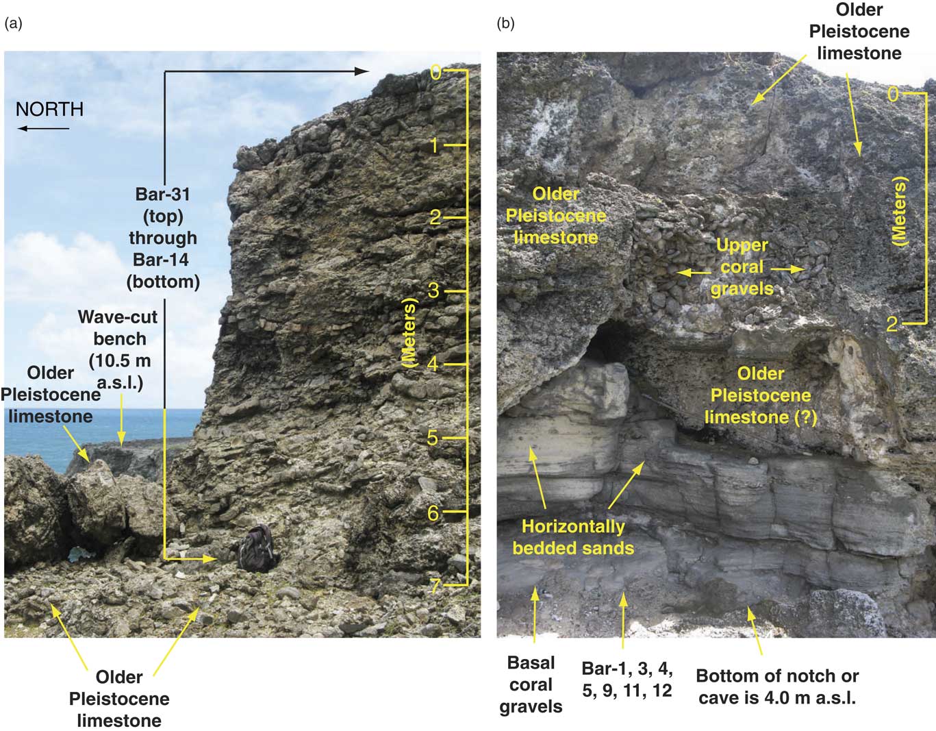
Spectacular outcrops occur in cliff sections exposed all along the coast from Touce’s Point to Sandy Hill Point. At Touce’s Point, an old, highly altered Pleistocene limestone is exposed from sea level to 10.5 m asl (Fig. 5a). What we interpret as a wave-cut bench truncates the older Pleistocene limestone 10.5 m asl. No unrecrystallized corals suitable for dating were found within the older Pleistocene limestone, but corals, dominated by A. palmata, are well preserved in the ~7 m of younger Pleistocene limestone found above the wave-cut bench (Fig. 5 and 6a).
(color online) Photographs showing stratigraphy and sampling localities in cliff section exposures at Touce’s Point. (a) Stratigraphy and generalized locations of samples in last-interglacial terrace deposits above wave-cut bench at 10.5 m above modern sea level. Base of what is interpreted as the last interglacial deposit, at the contact with the wave-cut bench, is at 13°20.027′N, 59°37.262′W. (b) Stratigraphy and samples in cave/notch ~4 m above modern sea level, cut into older Pleistocene limestone. Photographs by the authors.

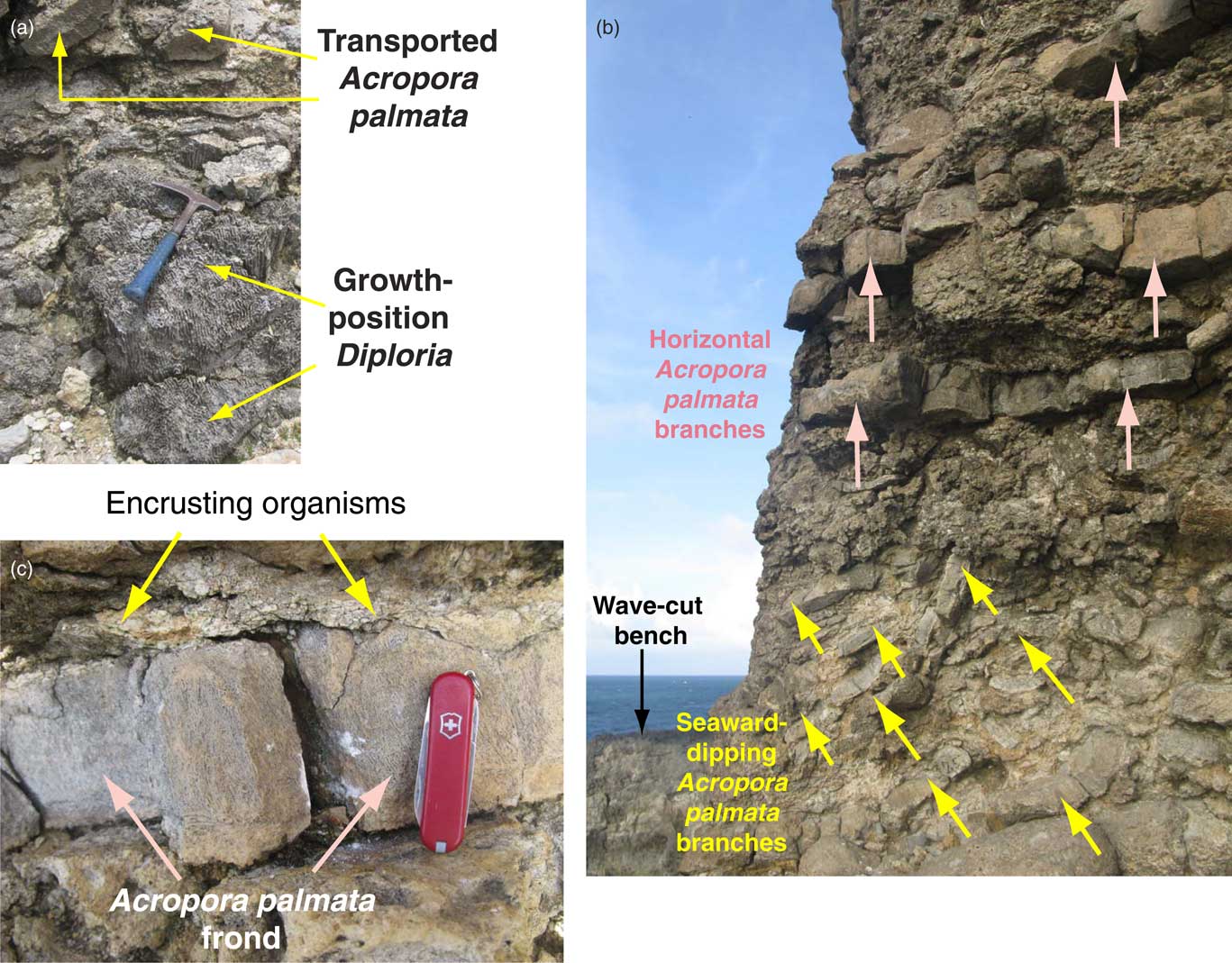
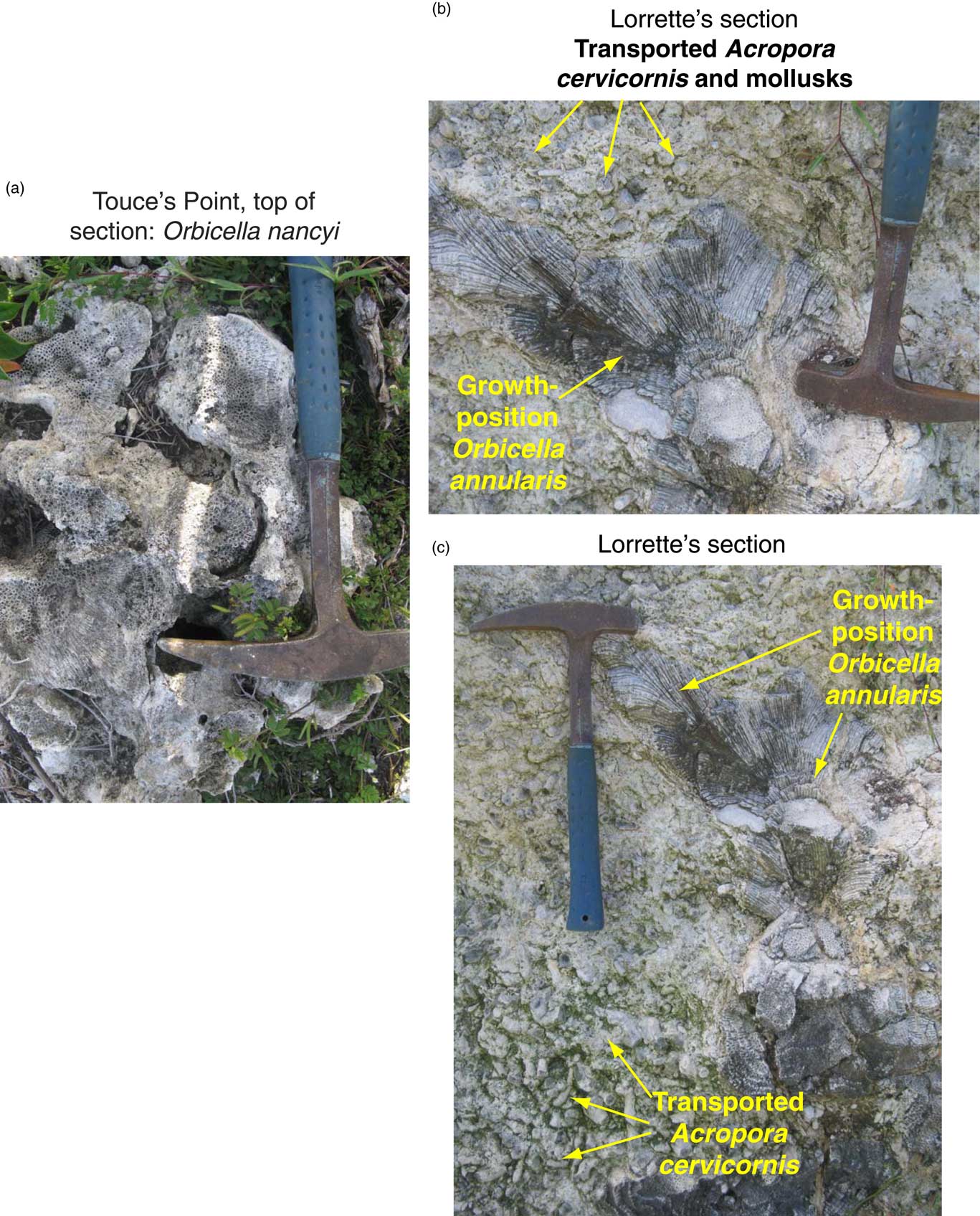
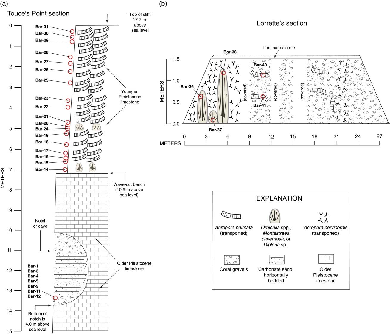
Considerable effort was focused on corals within the younger Pleistocene limestone at Touce’s Point, above the wave-cut bench cut on the older Pleistocene limestone (Figs. 5–7). A Diploria zone is found on the bench, with coral heads that appear to be in growth position (Fig. 7a). Montastraea cavernosa heads are also present within this lowermost zone, which is about a meter or less thick. Overlying the Diploria and Montastraea heads is a thick (~6.0–6.5 m) zone of Acropora palmata fragments with long axes that either dip seaward or are horizontal (Fig. 7b). Many A. palmata fragments have encrusting coralline algal colonies on the upper surfaces of individual branches (Fig. 7c), similar to what is reported by Perry (Reference Perry2001) from River Bay. Species of coral other than A. palmata are rare within this zone at Touce’s Point, although Montastraea cavernosa corals were found ~5.0 m below the top of the cliff section. In contrast to the lowermost zone with Diploria and Montastraea cavernosa, it is not clear whether the M. cavernosa coral heads higher in the section are in growth position. At the very top of the section, much of the limestone is highly altered, but we found what appears to be partly recrystallized Orbicella nancyi (= former Montastraea nancyi; see Pandolfi [Reference Pandolfi2007]) in a few places on the surface (Fig. 8a), but slightly landward of the cliff section. Overall, 18 specimens were collected for U-series dating (Fig. 6 and 9).
(a) Diploria sp. (Bar-14), bottom of the section at Touce’s Point, growing on the wave-cut bench at 10.5 m elevation; rock hammer for scale is ~0.3 m long. (b) Photograph of hypothesized Rendezvous Hill terrace exposure at Touce’s Point (close-up of exposure shown in Fig. 6a), showing fossil Acropora palmata branches. Pink arrows point to branches that are bedded horizontally or subhorizontally; yellow arrows point to seaward-dipping branches of A. palmata that show some indication of imbrication. (c) Close-up photograph of Acropora palmata clast in horizontal position (Bar-26 of Table 1) and encrusting organisms such as coralline algae on upper surface of clast; knife is 5.5 cm long. Photographs by the authors. (For interpretation of the references to color in this figure legend, the reader is referred to the web version of this article.)

(color online) (a) Colonies of Orbicella nancyi (?) at the top of the section at Touce’s Point. (b) Detailed view of Orbicella annularis at Lorrette’s section, likely in growth position, with transported Acropora cervicornis sticks and mollusks surrounding it. (c) The same Orbicella annularis colonies as in (b), but a longer view. Rock hammer for scale is ~0.3 m long. Photographs by the authors.

(color online) (a) Stratigraphy and detailed sampling depths in cliff section exposure at Touce’s Point, keyed to Table 1. (b) Lorrette’s section (informal name taken from local landowner) of the Rendezvous Hill terrace, exposed in road cut and location of samples taken. See Fig. 4a for section location. Coordinates are: 13°19.669′N, 59°36.656′W.

In places along the northern coast of Barbados, there is a notch cut into the older Pleistocene limestone, ~4–5 m asl (Fig. 5b). At Touce’s Point itself, we found a notch or small sea cave, several meters wide, with its base at 4.0 m asl (Fig. 6b). Based on the similar elevation, this feature may be the equivalent of the notch visible in Figure 5b. Within the notch or sea cave shown in Figure 6b, there is a thin (~0.2 m) basal layer of coral cobbles consisting of Acropora palmata, Acropora sp. or spp., Orbicella annularis complex corals (= former Montastraea annularis complex; see Budd et al. [Reference Budd, Fukami, Smith and Knowlton2012]), Montastraea cavernosa, and Diploria sp. This cobble layer is overlain by ~2.4 m of well-bedded, horizontal sand, in turn overlain by ~1.0 m of coral cobbles. The best preserved corals were found in the basal cobble layer and we collected a number of these for U-series dating.
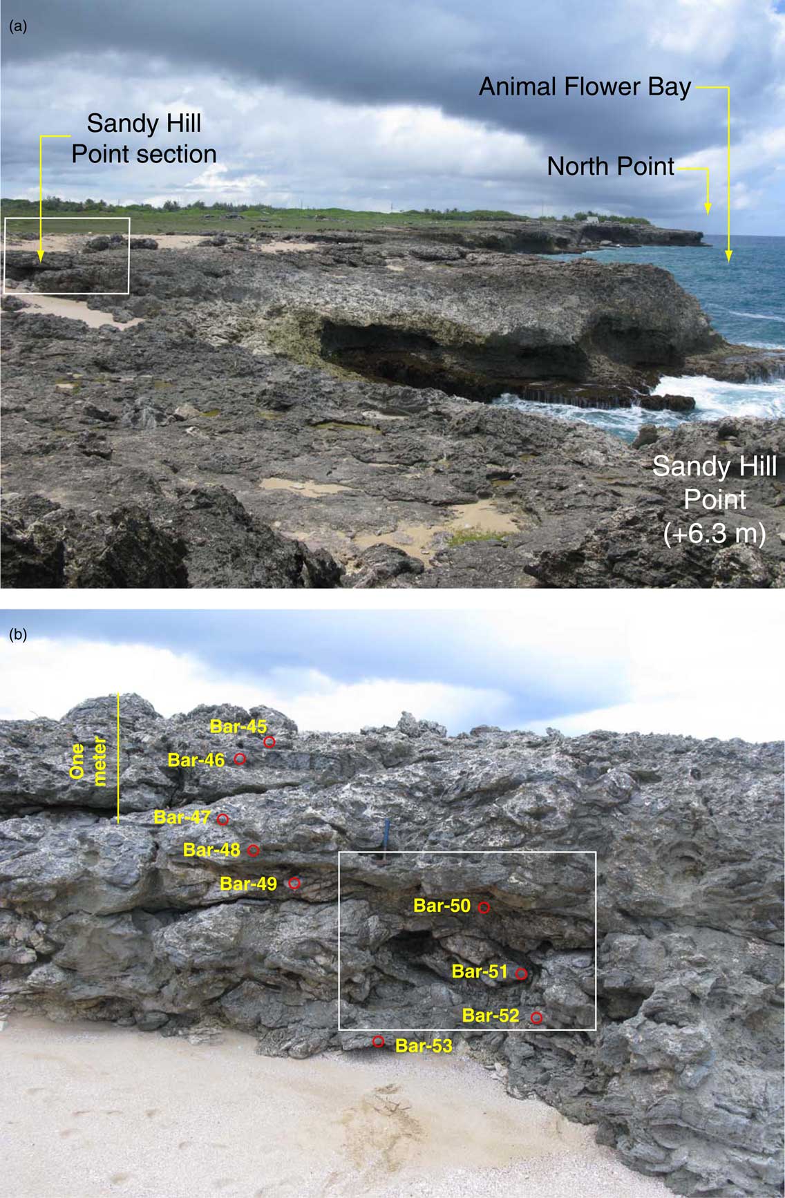
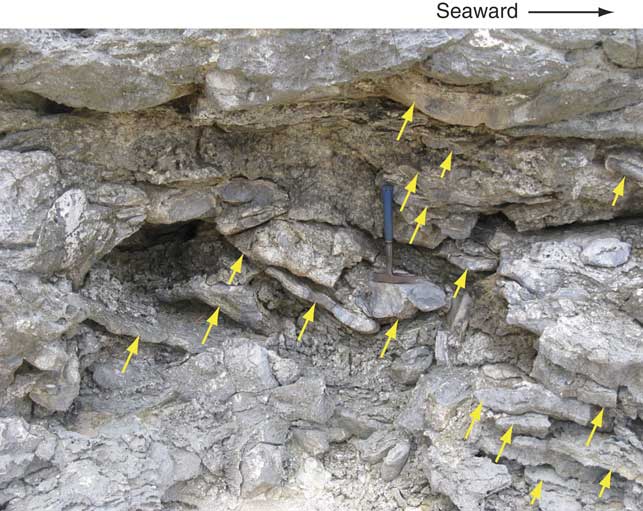
At Sandy Hill Point (Fig. 4a), shorter cliff sections are exposed (Fig. 10a) and we studied one a few meters landward of the coast, exposed in a small cove (Fig. 10b). A small pocket beach is found in the landward portion of this cove. Approximately 3 m of corals are exposed here, dominated by A. palmata. None of the corals appear to be in growth position and, as at Touce’s Point, they consist of broken branches that are either horizontal or subhorizontal, with seaward dips (Fig. 11). As is the case at Touce’s Point, what we interpret to be encrusting algal layers are found on the tops of some of these branches, particularly in the lower part of the section. Nine specimens of A. palmata in this section were collected for U-series dating (Fig. 10b).
(color online) (a) Photograph of the Sandy Hill Point area of northern Barbados (see Fig. 4a for locality) showing limestone of the hypothesized Rendezvous Hill terrace, seaward portion. Box shows area where Sandy Hill Point section was studied. (b) Photograph of the Sandy Hill Point section shown as boxed area in (a) showing sampling points. Boxed area shown in (b) is enlarged in Fig. 11; coordinates of locality are: 13°19.940′N, 59°36.483′W. Photographs by the authors.

Close-up of fossil Acropora palmata exposed in the Sandy Hill Point section (see Fig. 10b, boxed area); rock hammer (~0.3 m long) for scale. Yellow arrows point to imbricated, seaward-dipping A. palmata branches. Photograph by the authors. (For interpretation of the references to color in this figure legend, the reader is referred to the web version of this article.)

Inland of Sandy Hill Point to the southwest (Fig. 4a and b), there are short exposures of limestone across the terrace surface, ~2 m or less in height, mostly in artificial cuts. Corals in these exposures are dominantly transported A. palmata and A. cervicornis. The best exposure, and the one that is farthest inland, is the one we have informally named Lorrette’s section (Fig. 9b). The northeastern part of this 27-m-long exposure displays ~1.5 m of coral cobbles, with larger transported fragments of A. palmata and smaller A. cervicornis branches. The southwestern part of the exposure has Orbicella annularis complex corals and Diploria heads, apparently in growth position, surrounded by transported A. cervicornis sticks (Fig. 8b and c). The entire section is capped by a pedogenic, laminar calcrete, similar to those described by James (Reference James1972b) elsewhere on Barbados. In the transect from Sandy Hill Point inland to Lorrette’s section (Fig. 4b), the terrace geomorphology, coral taxa, and lateral facies changes are very similar to what is described from northeastern Barbados (fig. 3 in James et al., Reference James, Stearn and Harrison1977).
Uranium-series ages of corals
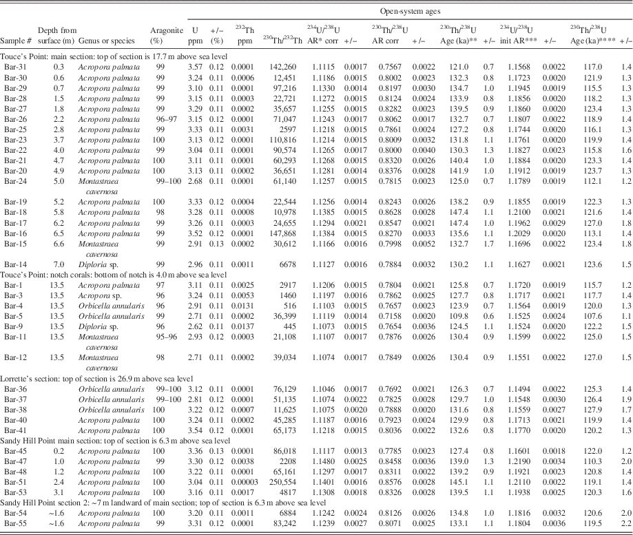
All corals analyzed here are mostly or completely free of recrystallization. All are ≥95% aragonite and only one is as low as 95–96%. Seven others are 96–98% aragonite and the remaining 29 specimens are 99–100% aragonite (Table 1). All samples of fossil A. palmata have U concentrations of 3.0–3.6 ppm, within the range of unrecrystallized fossils of this species reported elsewhere, and similar to what has been reported for modern samples of this species (Cross and Cross, Reference Cross and Cross1983). With two exceptions (Bar-36 and Bar-38), all samples of Orbicella, Montastraea, or Diploria have U contents of 2.62–2.96 ppm, again similar to what has been reported for fossils of these genera elsewhere and similar to living or modern dead specimens (Cross and Cross, Reference Cross and Cross1983; Muhs et al., Reference Muhs, Simmons, Schumann and Halley2011). Thus, there is no measurable evidence of significant post-mortem gain or loss of bulk U. Concentrations of 232Th in the corals range from 0.01 ppm to less than 0.0001 ppm. Twenty-seven of the corals have 232Th concentrations of less than 0.001 ppm. As a result, all but nine samples have 230Th/232Th values >10,000 (Table 1). Thus, for most samples analyzed here, inherited 230Th is insignificant.
Study localities, genera, aragonite contents, U and 232Th concentrations, isotope activity ratios, and uranium-series ages of corals from northern Barbados.

* AR, activity ratio; errors are absolute and two-sigma
** Calculated using half-lives of 75,584 yr for 230Th and 245,620 yr for 234U (Cheng et al., Reference Cheng, Edwards, Shen, Polyak, Asmerom, Woodhead and Hellstrom2013); errors are two-sigma.
*** Back-calculated initial 234U/238U value using 230Th/238U age and measured 234U/238U value; errors are two-sigma.
**** Open-system ages calculated using method of Thompson et al. (Reference Thompson, Spiegelman, Goldstein and Speed2003); errors are two-sigma.
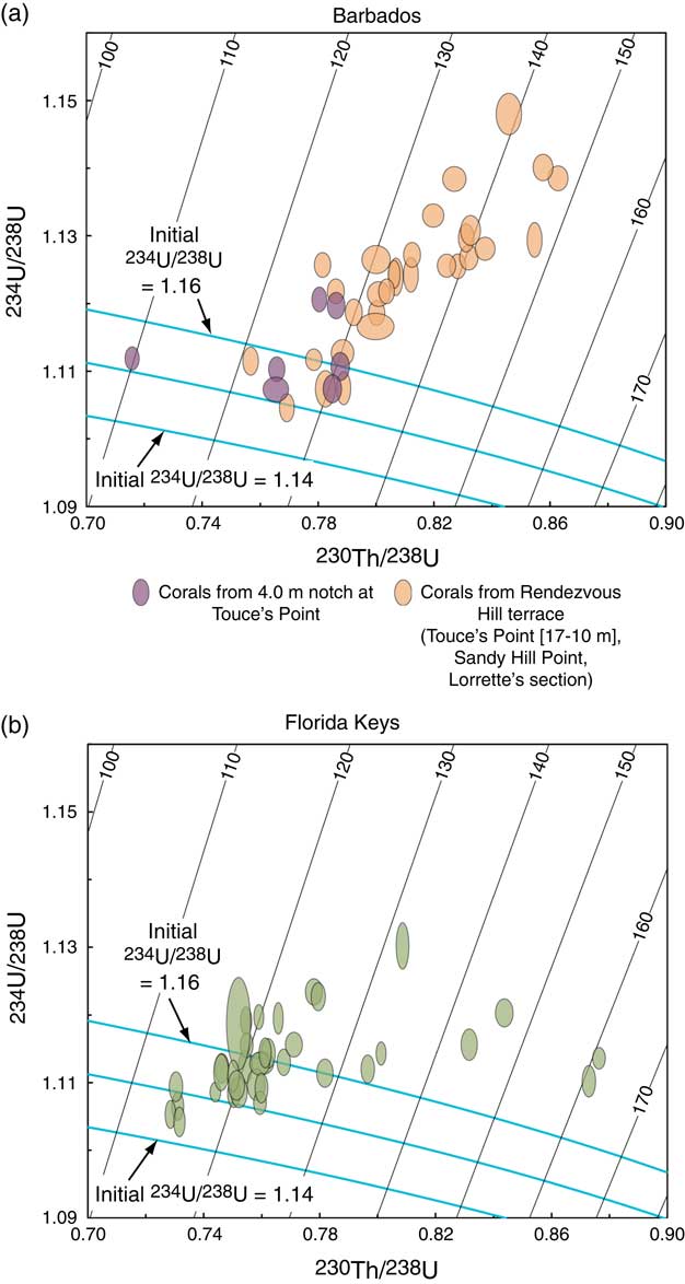
Gallup et al. (Reference Gallup, Edwards and Johnson1994) point out that the samples they studied on Barbados with elevated initial 234U/238U values from within the same reef terrace tend to yield older apparent ages. Data from other studies and the present work support this observation. On a 230Th/238U vs. 234U/238U diagram, such samples will plot above a theoretical isotope evolution pathway. Corals from Barbados, reported here (Fig. 12a) and those from the Florida Keys (Fig. 12b), reported by Muhs et al. (Reference Muhs, Simmons, Schumann and Halley2011), display the same tendency described by Gallup et al. (Reference Gallup, Edwards and Johnson1994).
Isotope evolution diagrams showing sympathetic variation of 234U/238U and 230Th/238U values (blue lines) over time in corals with initial activity 234U/238U values of 1.14, 1.15, and 1.16, approximately bracketing the range of values found in modern seawater (Chen et al., Reference Chen, Edwards and Wasserburg1986; Delanghe et al., Reference Delanghe, Bard and Hamelin2002). Ellipses show measured values with 2-sigma ranges for 234U/238U and 230Th/238U in fossil corals from (a) Barbados (this study) and (b) the Florida Keys (from Muhs et al., Reference Muhs, Simmons, Schumann and Halley2011). Diagonal lines are ischrons with ages in thousands of years (ka). Diagram constructed using Isoplot software (Ludwig, Reference Ludwig2001). (For interpretation of the references to color in this figure legend, the reader is referred to the web version of this article.)

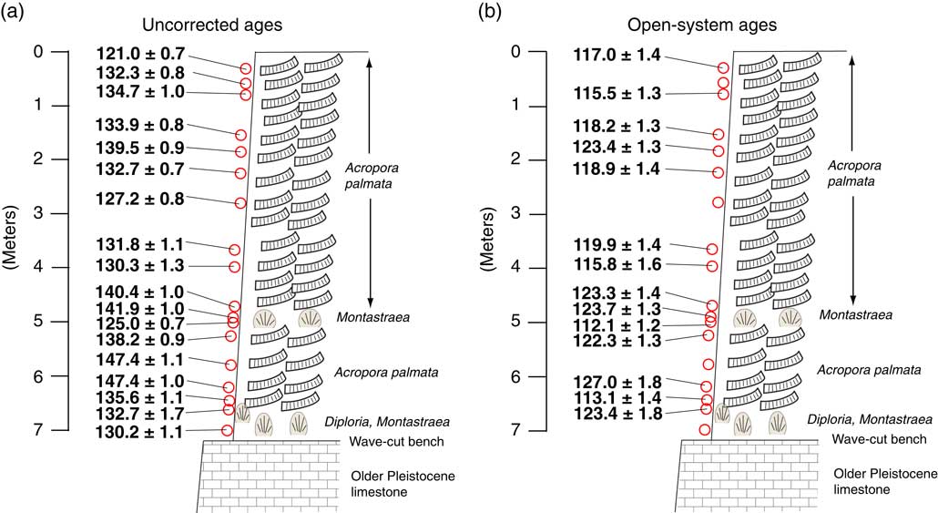
By the four criteria given earlier in the methods section, nine samples analyzed have possible closed-system histories, within the limits of analytical uncertainties. Three of these are growth-position specimens of the O. annularis complex from Lorrette’s section, with ages of 131.6 ± 0.8 ka, 129.7±1.0 ka, and 126.3±0.7 ka (Table 1). Five other specimens with possible closed-system histories are from the notch or cave cut into older Pleistocene limestone at Touce’s Point. Four of these samples, M. cavernosa (two specimens), a single O. annularis, and a single Diploria sp., yielded ages ranging from 130.4±0.9 ka to 123.9±0.7 ka. A fifth specimen from the notch/cave, Bar-5, yielded a significantly younger age of 109.8±0.6 ka. Most of the specimens from the Sandy Hill Point sections gave initial 234U/238U activity values in excess of 1.19–1.22, although Bar-45 (A. palmata) yielded an age of 127.4±0.8 and an initial 234U/238U activity value of 1.16. From the thick section at Touce’s Point, only a single A. palmata, Bar-31, near the top of the section, had an initial 234U/238U activity value less than 1.16 and this gave an age of 121.0 ± 0.7 ka. All of the other corals from the thick section at Touce’s Point gave apparent ages of ~147 ka to ~125 ka. However, the elevated initial 234U/238U activity values (Fig. 12a) of these corals indicate that all of these apparent ages are likely biased old.
Open-system ages of fossil corals
Following on the observations made by Gallup et al. (Reference Gallup, Edwards and Johnson1994), Thompson et al. (Reference Thompson, Spiegelman, Goldstein and Speed2003) proposed a method for correcting apparent U-series ages for corals with higher-than-acceptable initial 234U/238U activity values. The method is based on the theory that after terrace emergence from sea-level fall and/or uplift, dissolved 238U and 234U in terrestrial waters passing through corals and their host sediments produce 234Th and 230Th daughters that are emplaced onto solid surfaces (such as coral) by alpha-recoil. The result of this process is older apparent U-series ages of corals and higher apparent initial 234U/238U activity values. The phenomenon of nuclide emplacement onto solid particles by alpha recoil from U isotopes in solution has been observed for some time and was part of the basis for the experimental, open-system “uranium trend” dating method developed by J.N. Rosholt of the U.S. Geological Survey (Rosholt et al., Reference Rosholt, Swadley and Bush1988; Muhs et al., Reference Muhs, Rosholt and Bush1989). Thompson et al. (Reference Thompson, Spiegelman, Goldstein and Speed2003) developed their open-system correction method using fossil corals from Barbados, so it is appropriate to consider how this correction method could apply to corals in the present study.
Ages of the corals were recalculated using the open-system method of Thompson et al. (Reference Thompson, Spiegelman, Goldstein and Speed2003). The only modification made in these calculations was use of the new half-lives for 234U and 230Th presented by Cheng et al. (Reference Cheng, Edwards, Shen, Polyak, Asmerom, Woodhead and Hellstrom2013). Following a criterion used in a later study by Thompson et al. (Reference Thompson, Curran, Wilson and White2011), we did not include those corals from Touce’s Point that contain 232Th in amounts greater than 0.0004 ppm. This criterion eliminated 4 of the 18 corals at this section, but the surviving 14 samples are distributed along almost the entire vertical section (Fig. 13). All open-system ages are, of course, younger than their uncorrected ages, although the degree of correction varies with the degree of elevation of 234U/238U activity values. The corrected, open-system ages do not bring the coral ages into stratigraphic agreement. The range of open-system ages within the deposits at Touce’s Point is ~127 ka to ~112 ka (Fig. 13 and Table 1).
(color online) Cliff section exposed at Touce’s Point, showing (bottom to top): older Pleistocene limestone, wave-cut bench, and last-interglacial corals of the Rendezvous Hill terrace, slightly modified from Fig. 9a. (a) Uncorrected, apparent U-series ages of all samples collected from this section (from Table 1). (b) Open-system ages of same corals as in (a), using correction scheme of Thompson et al. (Reference Thompson, Spiegelman, Goldstein and Speed2003). Open-system ages of samples that contain more than 0.0004 ppm Th (see Table 1) are not shown.

In the other sections studied, we also calculated open-system ages. At Sandy Hill Point, samples Bar-47, Bar-53, and Bar-54 have 232Th concentrations that are too high using the Thompson et al. (Reference Thompson, Curran, Wilson and White2011) limit. The remaining four samples have open-system ages of ~122 ka to ~119 ka (Table 1). At Lorrette’s section, transported Acropora palmata corals have open-system ages of ~120 ka, similar to those at Sandy Hill Point. The growth-position samples of Orbicella annularis at Lorrette’s section have open-system ages that are somewhat older, ranging from ~128 ka to ~125 ka. In the notch or sea cave at Touce’s Point, four corals have 232Th in amounts greater than 0.0004 ppm. Two Montastraea cavernosa samples, however, had acceptably low 232Th concentrations and gave open-system ages of ~127 ka and ~125 ka (Table 1). An Orbicella annularis sample, however, gave an open-system age of ~108 ka.
DISCUSSION
Evidence of a storm deposit origin for Pleistocene Acropora palmata on northern Barbados
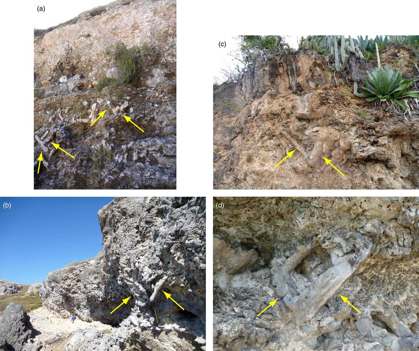
Acropora palmata has a very distinctive morphology, with large branches extending outward at variable angles from horizontal when it is growing (see fig. 1 of Kuffner and Toth [Reference Kuffner and Toth2016] for a modern example). Blanchon and Eisenhauer (Reference Blanchon and Eisenhauer2001) considered that “in situ” fossil A. palmata, in a fabric analysis, should have branches at angles of 20° to 60° from horizontal. Fossil coral reefs that have A. palmata still in growth position are easy to detect with this characteristic fabric and we have observed such corals in last-interglacial-age reefs on Curaçao and at Guantanamo Bay, Cuba (Fig. 14; Muhs et al., Reference Muhs, Pandolfi, Simmons and Schumann2012a, Reference Muhs, Schweig, Simmons and Halley2015). In contrast, Blanchon and Eisenhauer (Reference Blanchon and Eisenhauer2001) considered that branches of fossil A. palmata found at angles lower than ~20° (and of shorter lengths than living A. palmata) are detrital clasts, broken and reworked. Branches of A. palamata, when broken off from the main colony, are tabular and can range in length from 0.2 to 1.4 m (Blanchon and Eisenhauer, Reference Blanchon and Eisenhauer2001). Scheffers and Kinis (Reference Scheffers and Kinis2014) point out that imbrication of tabular clasts is common in many sedimentary environments. Where very large tabular clasts, such as A. palmata fragments, are imbricated with seaward dips, transport by strong onshore storm waves or a tsunami can be inferred.
(a and b). Photographs of growth-position fossil Acropora palmata of last interglacial age (see Muhs et al., Reference Muhs, Schweig, Simmons and Halley2015) taken at two locations (Cable Beach and Chapman Beach) near Guantanamo Bay, Cuba: (a) exposure at Cable Beach; (b) exposure at Chapman Beach. (c and d). Photographs of growth-position fossil Acropora palmata of last interglacial age (see Muhs et al., Reference Muhs, Pandolfi, Simmons and Schumann2012a) taken at two locations (Westpuntbai and Punta Halvedag) on the island of Curaçao: (c) exposure at Westpuntbai; (d) exposure at Punta Halvedag. Note angular position of branches joined at the base (yellow arrows) in these deposits. Photographs by the authors. (For interpretation of the references to color in this figure legend, the reader is referred to the web version of this article.)

Similar to the interpretation of Perry (Reference Perry2001) at nearby River Bay, we consider the sediments overlying the growth-position Diploria and Montastraea zone at Touce’s Point to be storm deposits. In contrast to the growth-position corals found on Curaçao and at Guantanamo Bay (Fig. 14), what we observe in most of the section at Touce’s Point are broken branches or fronds of A. palmata. Similar to what is described by Blanchon and Eisenhauer (Reference Blanchon and Eisenhauer2001), many of the A. palmata clasts at Touce’s Point have long axes that rest at angles lower than 20° from horizontal and most are nearly horizontal in the middle part of the section (red arrows in Fig. 7b). In the lower part of the section at Touce’s Point and at Sandy Hill Point, the A. palmata clasts are not horizontal, but dip gently seaward in an imbricated pattern, similar to what Scheffers and Kinis (Reference Scheffers and Kinis2014) describe as the expression of tabular clasts deposited by storms (yellow arrows in Fig. 7b and 11).
Age of the lowest marine terrace in northern Barbados
Growth-position corals from two widely spaced localities, 27 m asl (inland) and 10.5 m asl (seaward), allow us to assess the age of the lowest terrace in northern Barbados. At Lorrette’s section, three O. annularis complex corals in growth position (Bar-36, Bar-37, and Bar-38) yielded U-series ages of ~132 ka to ~126 ka, with open-system ages of ~128 ka to ~125 ka. The other likely growth-position corals are the Diploria sp. (Bar-14) and Montastraea cavernosa (Bar-15) specimens collected on the 10.5-meter-high, wave-cut bench at Touce’s Point. These two corals gave uncorrected ages of ~130 ka and ~133 ka, with open-system ages of ~124 ka and ~123 ka, although we caution that Bar-14 has a relatively high 232Th concentration.
The ages of growth-position corals from Lorrette’s section (inland) and the top of the wave-cut bench at Touce’s Point (seaward) indicate that the marine terrace in the northern part of Barbados is the equivalent of the Rendezvous Hill terrace of last-interglacial age (MIS 5.5) found farther south on the island. This interpretation is in agreement with mapping by Taylor and Mann (Reference Taylor and Mann1991) and the speculations of Broecker et al. (Reference Broecker, Thurber, Goddard, Ku, Matthews and Mesolella1968), Mesolella et al. (Reference Mesolella, Matthews, Broecker and Thurber1969), and Speed (Reference Speed2012) that the terrace in this part of Barbados is of last interglacial age, although no ages are given in these earlier studies. Poole and Barker (Reference Poole and Barker1983) also provided no new ages, but thought the terrace was of middle Pleistocene age. Radtke et al. (Reference Radtke, Grün and Schwarcz1988) studied road cut exposures ~700 m south of Animal Flower Cave, at elevations of 23–27 m. This locality is ~300 m to the west-northwest of Lorrette’s section. At their 23-m-high locality, they reported a U-series age of ~98 ka and an ESR age of ~271 ka; at the 27-m-high locality slightly to the south, they reported U-series ages of ~106 ka, ~107 ka, and ~147 ka and an ESR age of ~168 ka. However, Schellmann and Radtke (Reference Schellmann and Radtke2004b) re-dated corals from the 23-m-high locality by ESR and reported ages of ~123 ka and ~122 ka, in agreement with our results.
James (Reference James1972a) and James et al. (Reference James, Stearn and Harrison1977) thought that the ~125 ka terrace was present in this part of Barbados, but was overlain by reef corals dating to the ~80 ka (MIS 5.1) high-sea stand or the ~105 ka (MIS 5.3) high-sea stand. This scenario (as shown in Fig. 10 of Radtke et al. [Reference Radtke, Grün and Schwarcz1988]) would actually require subsidence of the ~125 ka reef before deposition of either the ~105 ka or ~80 ka reefs. Some simple calculations indicate that the long-term trend here has been uplift at a modest rate, by assuming the following: (1) the elevation (~27 m) of the reef limestone O. annularis complex corals at Lorrette’s section represents approximately the peak of the ~125 ka high-sea stand; (2) an adjustment is made for a minimum of a 3 m water depth habitat for O. annularis (Shinn et al., Reference Shinn, Lidz, Kindinger, Hudson and Halley1989); and (3) a paleo-sea level of +6 m at ~125 ka is used (see discussion in Muhs et al., Reference Muhs, Simmons, Schumann and Halley2011). These considerations imply ~24 m of uplift in ~125 ka, for an uplift rate of ~0.19 m/ka. This uplift rate is similar to that reported for this part of Barbados by Taylor and Mann (Reference Taylor and Mann1991).
Range of ages within coral-bearing storm deposits at Touce’s Point
Above the wave-cut bench at Touce’s Point, broken Acropora palmata fronds dominate the section. Consistent with the storm-deposit origin described above, ages do not get progressively younger up-section, whether we rely on U-series ages at face value or use the open-system ages calculated from Thompson et al.’s (Reference Thompson, Spiegelman, Goldstein and Speed2003) method. Thompson et al.’s (Reference Thompson, Curran, Wilson and White2011) open-system coral ages from last-interglacial reefs in the tectonically stable Bahamas (Fig. 1) range from ~126 ka to ~113 ka. From the tectonically stable Florida Keys (Fig. 1), we calculated open-system ages of last-interglacial corals reported by Muhs et al. (Reference Muhs, Simmons, Schumann and Halley2011), eliminating those specimens with greater than 0.0004 ppm 232Th. The range of ages for the Florida corals is ~126 ka to ~111 ka, which is not significantly different from Thompson et al.’s (Reference Thompson, Curran, Wilson and White2011) age range for the Bahamas. Open-system coral ages from the storm deposits at the Touce’s Point section show a very similar range to the Bahamas and Florida, from ~127 ka to ~112 ka (Table 1). These observations indicate that while many ages of corals are represented in the storm deposits, they apparently all date to the last interglacial period, MIS 5.5. Thus, in contrast to the ESR ages of corals reported by Radtke et al. (Reference Radtke, Grün and Schwarcz1988) from south of Animal Flower Cave and Schellmann and Radtke (Reference Schellmann and Radtke2004b) from River Bay, we find evidence of corals from only one high-sea stand at Touce’s Point. Furthermore, given that the youngest A. palmata fronds (open-system ages for Bar-24 of ~112 ka at 5 m depth; for Bar-16, ~113 ka at 6.5 m depth) are found relatively deep in the section, we infer that deposition of coral clasts from storms occurred relatively late in the last interglacial period.
Evidence of fossil coral mixing from the notch deposits at Touce’s Point
In contrast to the results from the A. palmata clasts on the 10.5 m bench, the ages of the coral cobbles found in the 4.0 m notch at Touce’s Point provide an example of mixing of corals from two high-sea stands. The detrital coral cobbles in this notch or cave gave mostly MIS 5.5 ages (both uncorrected and open-system ages), but one coral cobble gave an uncorrected age of 109.8 ± 0.6 ka (with an open-system age of 107.6 ± 1.1 ka), which falls into the age range of MIS 5.3. In southern and western Barbados, the Ventnor terrace represents MIS 5.3, as described earlier (Bender et al., Reference Bender, Fairbanks, Taylor, Matthews, Goddard and Broecker1979; Gallup et al., Reference Gallup, Edwards and Johnson1994; Edwards et al., Reference Edwards, Cheng, Murrell and Goldstein1997). One interpretation that can be made from Touce’s Point is that the notch was cut into the older Pleistocene limestone during the ~105 ka high-sea stand, and detrital, wave-worn coral gravels from both that high sea-stand and the ~125 ka high-sea stand were reworked into the notch. If we assume that the uplift rate calculated above for the Rendezvous Hill terrace (based on the age and elevation of growth-position corals at Lorrette’s section) has been steady over the past ~125 ka, then there should have been ~20 m of uplift in the past ~105 ka. Because the notch’s lower part is 4.0 m asl, a paleo-sea level of -16 m, relative to present, is therefore required at ~105 ka.
We can compare the estimated paleo-sea level at MIS 5.3 time at Touce’s Point with data reported elsewhere on Barbados. Late Quaternary uplift rates on Barbados vary in a shore-parallel sense around the coast due to local structural control, and range from 0.07–0.44 m/ka (Taylor and Mann, Reference Taylor and Mann1991). The Clermont-Mount Hillaby anticline area of Barbados, just north of Bridgetown (Fig. 2) has been the classical area for past studies of Barbados sea-level history, and likely has the highest uplift rate on the island (Taylor and Mann, Reference Taylor and Mann1991). Here, the ~125 ka Rendezvous Hill terrace has a reef crest elevation of ~61 m and the ~105 ka Ventnor terrace immediately seaward of it (Fig. 2) has a reef crest elevation of ~30 m (Bender et al., Reference Bender, Fairbanks, Taylor, Matthews, Goddard and Broecker1979; Taylor and Mann, Reference Taylor and Mann1991). Because the reef crests of both of these terraces are dominated by the shallow water species A. palmata in growth position (Mesolella et al., Reference Mesolella, Matthews, Broecker and Thurber1969), no significant correction needs to be made for habitat depth, as we did for a paleo-sea level estimate at Lorrette’s section. Using the ~61 m elevation and a +6 m paleo-sea level (as above) yields an uplift rate of 0.44 m/ka over the past ~125 ka in the Clermont-Mount Hillaby area. At this rate, ~46 m of uplift likely occurred in the past ~105 ka. The Ventnor terrace’s present elevation of ~30 m would therefore require a paleo-sea level of -16 m, the same as what we calculate for the North Point area of Barbados. We infer, therefore, that it is possible the notch at Touce’s Point was cut during the ~105 ka high-sea stand and correlates with the Ventnor terrace farther south. If this interpretation is correct, then it provides an example of fossil mixing in marine terrace deposits that consist of detrital corals, analogous to the high-energy coastline of Californa, where mixing of fossil corals of different ages has also been documented (Muhs et al., Reference Muhs, Simmons, Kennedy and Rockwell2002, Reference Muhs, Simmons, Schumann, Groves, Mitrovica and Laurel2012b). Of the seven corals analyzed from the 4.0 m notch deposit, six of them gave MIS 5.5 ages and only one gave an MIS 5.3 age. Had the one MIS 5.3 coral not been found or analyzed, an erroneous interpretation that might have been made is that the notch represents a second, somewhat lower high-sea stand within MIS 5.5.
Other evidence of fossil mixing from more than one high-sea stand on Barbados
There are other localities on Barbados where there is evidence for reworking of corals. In southwestern Barbados, Gallup et al. (Reference Gallup, Cheng, Taylor and Edwards2002) report ages of coral fragments (OC-1 and OC-2) from a locality on what is mapped as the Ventnor terrace. These corals gave ages of ~105 ka (MIS 5.3) and ~114-113 ka (MIS 5.5). These investigators also report coral fragments (OC-4 and OC-5) from a locality on what is mapped as the Worthing terrace that gave ages of ~110–108 ka (MIS 5.3) and ~117 ka (MIS 5.5). Thus, on a terrace previously established to be ~105 ka from growth-position corals, only ~3 km away (Broecker et al., Reference Broecker, Thurber, Goddard, Ku, Matthews and Mesolella1968; Mesolella et al., Reference Mesolella, Matthews, Broecker and Thurber1969; Gallup et al., Reference Gallup, Edwards and Johnson1994; Edwards et al., Reference Edwards, Cheng, Murrell and Goldstein1997), detrital corals of that age and older are found, and on a terrace established from growth-position corals to be ~80 ka, detrital corals of ~110–108 ka and ~117 ka are found.
In the study by Blanchon and Eisenhauer (Reference Blanchon and Eisenhauer2001) cited earlier, there is evidence that the storm deposits they described also likely date to more than one high-sea stand. At one of their sites near Gibbons in southern Barbados (Fig. 2), U-series data on their corals, like ours at Touce’s Point, show ages that are not consistent with the stratigraphy. Blanchon and Eisenhauer (Reference Blanchon and Eisenhauer2001) interpreted their inconsistent ages to be due to diagenetic effects, specifically open-system histories, as indicated by higher-than-expected initial 234U/238U values. Nevertheless, these corals (A. palmata) have little or no calcite, have U contents within the range of modern specimens of this taxon, and with one exception, have very low 232Th contents. In view of the possibility of “correcting” these ages for open-system histories, we recalculated their U-series ages using the Thompson et al. (Reference Thompson, Spiegelman, Goldstein and Speed2003) method. The open-system calculations give A. palmata ages of ~108 ka (at 7.25 m below the reef crest), ~102 ka (at 10.25 m below the reef crest), and ~109 ka (at 13.55 m below the reef crest), all of MIS 5.3 age, but with open-system MIS 5.5 ages (ranging from ~128 ka to ~117 ka) above (5.75 m), below (16.55 m), and between (8.75 m and 11.30 m) these younger ages. These data, combined with the fabric analyses, indicate that the Rendezvous Hill terrace deposits in this part of southern Barbados contain storm-deposited corals from both the ~125 ka (MIS 5.5) and ~105 (MIS 5.3) high-sea stands. If the Thompson et al. (Reference Thompson, Spiegelman, Goldstein and Speed2003) method of correcting U-series ages has validity, one implication of these results is that one cannot even trust which oxygen isotope substage a given terrace might correlate with, if only one or two isolated U-series analyses are conducted on corals not in growth position.
Of the numerous studies of Acropora palmata in uplifted reef terraces on Barbados, a few investigators have described their sampling strategy as limited to growth-position fossils (Mesolella et al., Reference Mesolella, Matthews, Broecker and Thurber1969; Radtke et al., Reference Radtke, Grün and Schwarcz1988) or at least have stated the importance of such sampling (Schellmann and Radtke, Reference Schellmann and Radtke2004a). Others have described their sampling to be dominantly from the reef crests (Bender et al., Reference Bender, Fairbanks, Taylor, Matthews, Goddard and Broecker1979; Gallup et al., Reference Gallup, Edwards and Johnson1994), which can be interpreted to mean growth-position corals were sampled. Still others have described their sampling as “in situ,” which can be interpreted to mean either corals in growth position or fragmented samples, but still found at or near where the corals once grew (Broecker et al., Reference Broecker, Thurber, Goddard, Ku, Matthews and Mesolella1968; Potter et al., Reference Potter, Esat, Schellmann, Radtke, Lambeck and McCulloch2004; Schellmann et al., Reference Schellmann, Radtke, Potter, Esat and McCulloch2004; Speed and Cheng, Reference Speed and Cheng2004). Speed and Cheng (Reference Speed and Cheng2004) point out that in some places on Barbados, colonies of Acropora palmata and A. cervicornis may not be found in growth position, but their present state of occurrence resulted from simple collapse, rather than significant horizontal transport. In cases like these, the elevation of dated corals may be fairly close to what would have been the elevation for a growth-position coral and there may be little danger of reworking from a wholly different terrace. Quite a number of studies from Barbados, however, do not indicate whether the corals sampled are in growth position (Bender et al., Reference Bender, Taylor and Matthews1973; Edwards et al., Reference Edwards, Chen and Wasserburg1987b; Bard et al., Reference Bard, Hamelin and Fairbanks1990; Hamelin et al., Reference Hamelin, Bard, Zindler and Fairbanks1991; Dia et al., Reference Dia, Cohen, O’Nions and Shackleton1992; Cutler et al., Reference Cutler, Edwards, Taylor, Cheng, Adkins, Gallup, Cutler, Burr and Bloom2003; Thompson and Goldstein, Reference Thompson and Goldstein2005). We suggest that with evidence of storm-wave transport of fossil corals from Barbados, investigators need to consider coral taphonomy and indicate explicitly the stratigraphic context of all corals sampled.
Constructional vs. erosional origin of marine terraces on Barbados
The early studies of Barbados sea-level history emphasized the constructional-landform origin of the terraces, where upward reef growth kept pace with rising seas during interglacials (Mesolella, Reference Mesolella1967; Broecker et al., Reference Broecker, Thurber, Goddard, Ku, Matthews and Mesolella1968; Mesolella et al., Reference Mesolella, Matthews, Broecker and Thurber1969, Reference Mesolella, Sealy and Matthews1970). This constructional process of landform genesis contrasts with high-wave-energy coasts in the mid-latitudes, such as California, where marine terraces form primarily by erosion of bedrock to form wave-cut benches and marine deposits are poorly sorted gravels, sands, and fossils left behind when the sea regresses (see review in Muhs et al., Reference Muhs, Wehmiller, Simmons and York2004). However, later investigators proposed that terraces on Barbados, at least in some localities, have an erosional component to their origins as well (Johnson, Reference Johnson2001; Speed and Cheng, Reference Speed and Cheng2004; Speed, Reference Speed2012). Indeed, Speed and Cheng (Reference Speed and Cheng2004) proposed that even in the southwestern part of Barbados, where distinct reef facies changes are generally well preserved, the earliest phase of terrace development was characterized by bench cutting.
A full testing of the alternative model of terrace genesis on Barbados presented by Speed and Cheng (Reference Speed and Cheng2004) is beyond the scope of the present study. Nevertheless, some of the observations we report here for northern Barbados provide relevant data for assessing the Speed and Cheng (Reference Speed and Cheng2004) model. At Touce’s Point, coral growth during the last interglacial period was preceded by formation of a wave-cut bench. The erosion surface that resulted from this is clearly visible in the cliff sections where it truncates earlier Pleistocene limestone (Fig. 5a–b, 6a). Coral reef growth post-dates the formation of the wave-cut bench, in agreement with Speed and Cheng (Reference Speed and Cheng2004). The sequence of events is also similar to what is reported by James et al. (Reference James, Stearn and Harrison1977), as illustrated in their Figure 3. Precisely when the bench at Touce’s Point was cut on the older Pleistocene limestone cannot be determined from the data we have here. However, sometime after this event, corals colonized the surface during MIS 5.5, based on open-system ages of ~124 ka to ~123 ka from growth-position coral heads (Diploria, Bar-14 and Montastraea cavernosa, Bar-15) alluded to above. Thus, marine terraces on Barbados are, in contrast to the prevailing model since the classic study of Mesolella (Reference Mesolella1967), constructional landforms on some parts of the island, but partly erosional landforms in other parts, such as the northern coast.
CONCLUSIONS
Barbados has been one of the most important places in the world for deciphering Quaternary sea-level history, but reworking of corals can potentially result in mixed fossil ages on a single terrace, which we explore here. At Touce’s Point in northern Barbados, study of a thick stack of storm-derived coral clasts resting on a wave-cut bench yielded 14 corals suitable for age correction using an open-system method. Corrected ages range from ~127 ka to ~112 ka, in good agreement with the MIS 5.5 age of underlying growth-position corals and growth-position corals found inland on the same terrace. Thus, in this particular case, despite the seaward location and the thick accumulation of coral clasts, storms apparently gathered only corals dating to the same high-sea stand that formed the terrace. Had only a limited number of corals been analyzed, there would have been no error in correlating this terrace with MIS 5.5.
In contrast, a notch or sea cave cut into the Pleistocene limestone below the wave-cut bench at Touce’s Point contains coral clasts dating to two high-sea stands. Of seven corals sampled, six date broadly to MIS 5.5, but one dates to MIS 5.3. The elevation of the notch/sea cave is consistent with formation during MIS 5.3 if the inland elevation of the MIS 5.5 terrace is used to compute a local uplift rate and to reconstruct local sea-level history. If we assume the notch/sea cave did, in fact, form during MIS 5.3, then, in this case, the majority of corals in the deposit are reworked and do not date the timing of the notch accurately. Had one less coral been sampled, this may not have been apparent, and an unwary investigator might have interpreted the notch to represent a second, somewhat lower sea stand during the MIS 5.5 interglacial.
A number of previous studies on Barbados have not provided information about whether corals collected were in growth position or were detrital. Our studies here, combined those of other researchers, lead us to believe that this is a hazardous practice, because detrital corals on marine terraces of Barbados appear to be common. In cases where this approach is combined with limited U-series dating, erroneous interpretations of sea-level histories can result.
Acknowledgments
This study was supported by the Climate and Land Use Change Research and Development Program of the U.S. Geological Survey (USGS) and is a contribution to the “Geologic records of high sea levels” project (http://gec.cr.usgs.gov/projects/sealevels/). Thanks go to the landowners (Lorrette Jordan of St. Lucy Parish and the friendly folks at Animal Flower Cave) in northern Barbados who graciously allowed us access for studying and sampling corals on their property. We thank Gary Skipp (USGS, Denver, CO), who X-rayed all the corals we collected for aragonite purity. We also appreciate helpful discussions with Noel P. James of Queen’s University about his early work on Barbados. Bill Thompson of Woods Hole kindly provided software for his open-system correction model, which was critical to our efforts here. Many thanks go to Lauren Toth (USGS, St. Petersburg, Florida), Janet Slate (USGS, Denver, Colorado), editors Derek Booth and Jamie Shulmeister, and two anonymous journal reviewers for helpful comments on an earlier version of the paper. Any use of trade, product, or firm names is for descriptive purposes only and does not imply endorsement by the U.S. Government.