


7.1 Introduction: Data/Infrastructure
“Infrastructures as regulation” and “governance by data” are suggestive designators of forms of ordering that are not directly legal but relate – as law does – to the generation and allocation of resources and status, the opening or constraining of future possibilities, and the shaping of behavior and all manner of relations.Footnote 1 “Infrastructures” and “data” have in common that they are relational, material, dynamic, complex, and scalar. A high proportion of infrastructures involve data, and almost all electronic digital data is collected, stored, moved, and used within infrastructures. Various melds of data and infrastructures are of tremendous significance in diverse areas of current and future regulatory governance, as well as to the formation and functioning of scientific knowledge. Knowledge and understanding of earth systems, and efforts in planetary and space governance, depend heavily on “data infrastructures.” For these reasons, the theory and practice of science-related data infrastructures and their governance demand attention.
Scientific data infrastructures are frequently discussed and analyzed as information and knowledge infrastructures.Footnote 2 Data infrastructures are, of course, largely about producing “knowledge” in the form of scientific insights and understanding of specific natural phenomena: the underlying driver for many participants (not all) is data as a means for producing information and then for generating knowledge. At the same time, data can shape imaginaries, define problems, create and “translate” processes and phenomena that are represented in data, draw boundaries (i.e., what is valid and what is “noise”), and embody normativities through choices around datafication (i.e., what becomes data), naming (i.e., what is being measured), standards (i.e., what becomes valid data), and modes of presentation (i.e., formats, visualizations, etc.).Footnote 3 Data can also enable action without ever becoming information or knowledge that is legible to humans, such as when data is transmitted between machines or is fed into a computational model. Data generation, processing, movement, and ultimate use is enabled by physical, digital, and knowledge infrastructures, each of which individually, collectively, interdependently, and/or in opposition to each other exert regulatory powers. It is through infrastructures that data is configured and reconfigured, channeled, blocked, stored, and made durable over a long time and across extended space – or fleeting and constrained.
In this chapter, we focus on the production of data about the ocean. With the urgencies of climate change and recognition of ocean’s importance in regulating climate, global-scale initiatives such as the Ocean Decade,Footnote 4 have focused on enhancing production of “ocean data” and improving observational capacities of countries to engage in such data production. Creating “a digital representation of the ocean” is one of the challenges articulated and embraced by the Ocean Decade initiative.
What role do governance arrangements, background legal rules, and the core infrastructures play in enabling data collection, determining what “ocean data” is produced, and when and how it is made available? We explore this question by focusing on data about oceanic features produced by the Argo network – an international program, operationalized by state agencies and research institutions, that comprises arrays of autonomous floats for ocean observation.Footnote 5 The floats, which drift with ocean currents and move vertically between the surface and mid-water levels, generate multidimensional spatial, temporal, sensory observation data about certain physical and biogeochemical properties of the oceans. The data is constituted and configured through physical and digital infrastructures that enable generation, transmission, and storage of data, knowledge infrastructures through which sensor data is transformed into data that is legible by scientific communities and usable for delineated purposes. This “sensing” data not only forms part of the ontology of what it is describing but also help make what the data is called to represent (in this case: “the ocean”).Footnote 6 Data, however, is necessarily reductive, partial, and incomplete – it is never the thing itself that it is meant to represent.Footnote 7 What it creates is a function of choices made at various temporal and spatial infrastructural sites: What data can be produced given existing technologies, capacities, needs, legacy infrastructures? What data has inferential potential? What data can be generated in a sustained fashion? How can relationality of (what) data be best leveraged? How can contextual variabilities be accounted for to arrive at commensurability (which itself raises questions of capacity, expertise, etc.)?
Argo’s socio-technical practices, aggregated with other ‘data infrastructures’ across different areas of scientific observational and modeling practice and across different scales, can have an onto-epistemologicalFootnote 8 effect, constructing and crystallizing a particular conception of “the ocean” (as one comprising sets of datafied physical and biogeochemical parameters) or of the self-reproducing vision of earth system, “consisting of interlinked physical, chemical, and biological processes that cycle materials and energy in non-linear, complex and dynamic ways within the system.”Footnote 9 Argo’s emphasis on openness and accessibility of data and generally participatory governance,Footnote 10 may enable users to leverage the relationality and recombinant potential of data to open up opportunities to rupture “fixed and bounded systems and the traditional notions of causality and agency, which lie at the heart of an autopoietic framing of the Earth system’s functioning” and instead reveal new ways of relating in more-than-human worlds.Footnote 11 By inverting Argo, we hope to generate insights about its regulatory ambivalence.Footnote 12 Thinking across scales – from localized sites of Argo decision-making processes to global aspirations for the development of “trusted, inclusive, and interconnected ocean data and information ecosystem that is actively used for decision making to support sustainable ocean management”Footnote 13 – we ask how thinking from infrastructure and data to “data infrastructure” may contribute to governance arrangements relating to observational science and planetary modeling.
In this spirit and drawing on our earlier work, we endeavor to “think infrastructurally” about Argo (Section 7.2). Through examination of annual meeting notes, interviews, and remote attendance of the Argo Steering Committee’s 2023 annual meeting, we analyze the techniques and practices involved in planning, testing, calibrating, validating, and error-correcting that ultimately lead to the production, transmission, and dissemination of Argo data. We analyze (in Section 7.3) the sites, processes, and interfaces that determine what data is being produced by whom, where, when, how, and why, as well as what data is not being produced, which interests remain neglected, and where and when no data is being generated. We then position Argo within the institutional governance related to oceans, weather, climate and, most recently, earth systems to illustrate both the evolution of Argo’s role and its evolving and uneasy position within different governance approaches (Section 7.4). In the conclusion, we challenge the utility of “ocean data” as an analytical category and highlight the risks of over-coordination and institutionalization of data infrastructures. We suggest that allowing data infrastructures like Argo to develop organically might lead to productive (if unexpected) connections, fusions, or splits, which might in turn reorient the focus of observation toward unexplored interactions between and within earth systems. Complementing legal reconstruction projects such as “earth systems law”Footnote 14 and “more-than-human constitutionalism,”Footnote 15 we ultimately hope that our analysis helps bring to the fore some core data-infrastructuralFootnote 16 features of planetary governance as it now exists and will (have to) rapidly further evolve.
7.2 Thinking Infrastructurally About Argo
“Thinking infrastructurally” entails understanding infrastructure not simply as a thing, but as a set of relations, processes, and imaginations.Footnote 17 The field of infrastructure studies has provided one set of observational perspectives: if it is an infrastructure it has technical, social, and organizational elements which all go together, and numerous gateways, interfaces, workarounds, alliances, upstream and downstream dependencies, re-purposing, perpetual maintenance and funding needs, and prospects or experience of incompletion, decay, and ruins.Footnote 18 The “actants” – in Actor-Network Theory parlance – include human, nonhuman, and indeed non-animate participants.Footnote 19
Like other infrastructures, Argo involves physical components, human labor, and layer upon layer of integrated, partly interconnected, or otherwise interfacing interdependent systems and networks. Like other data infrastructures, Argo is embedded in and constituted by legacy and coterminous knowledge infrastructures, including practices of scientific knowledge production and the larger (geo)political economy. Understanding Argo as an infrastructure entails studying its entangled technical, social, and organizational dimensions, with particular attention to continuities and legacies that shaped its development over time and space. Argo’s technical artifacts consist of various configurations of computational hardware and software, float design and sensor selection, satellite constellations, as well as data formats and websites. Its social conventions are characteristic of scientific knowledge production and related scientific practices of data collection and verification, and its organizational matrix involves research institutions, international organizations, funding structures, and various legal arrangements, ranging from float manufacturing contracts to the UN Convention on the Law of the Sea (UNCLOS).
Like many observational science or information-focused infrastructures, the Argo floats network is a composite, is embedded in other infrastructures, and has links to many more. We will suggest that this network is sustained and extended by the data, that the drive for data is the main precipitator of key components of the infrastructure which interact in the manner of a system, and that the infrastructure boundaries are regularly negotiated and may shift with new data demands and constituencies. A unified purposive agency is supplied by deliberations and decisions in the Argo governance institutions; but the diverse human processes which construct and operate the data infrastructures are fragmented and have multiple referents and interconnections.
For purposes of our analysis, we distinguish between Argo’s data generating infrastructures (the sensors and their floats, and their launch), Argo’s data transmission, location, and control infrastructures (enabled by satellites), and Argo’s data processing, storage, and dissemination infrastructures (provided by so called “data assembly centers”).
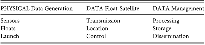
Table 7.1 Long description
A three-column table describing the main elements of the Argo Floats infrastructure or ‘stack’. Column One (Physical Data Generation) includes three elements – sensors, floats, and launch. Column Two (Data Float-Satellite) includes three elements – transmission, location and control. Column Three (Data management) includes three elements – processing, storage and dissemination.
One can think of these data infrastructures together as the “Argo stack” (see Table 7.1):Footnote 20 without sensors and floats there would be nothing to transmit, locate, or control; without the data transmission infrastructure, the data would be stuck on the floats; without the location infrastructure, “data about the ocean” could be data about anywhere in the ocean; without control infrastructures (e.g., limited directionality of the floats enabled by Iridium satellite two-way connectivity), floats would drift entirely aimlessly; without data storage infrastructure (including backups), data would be transient and could get lost; without data processing infrastructure, no scientifically relevant information could be gained from the data; and without data dissemination infrastructures, no one would be able to access and use the data for scientific research. Each of these infrastructures is itself constituted by a coming-together of the technical, the social, and the organizational. Together, they comprise Argo.
In the following three sub-sections, we navigate the Argo stack by following the “lifecycle” of Argo data,Footnote 21 beginning with data generation on the floats, followed by data transmission and float geolocation via satellites, to data processing and dissemination at data assembly centers. As becomes evident, control of data generating and transmission infrastructures is distributed among different public and private actors. Links, connections and inter-operations of different infrastructural components (e.g., satellites, sensors, floats, launching ships) are loosely coordinated by Argo members, often in ad hoc fashion. At the same time, durability and resilience of infrastructural inter-dependencies are critical to Argo being able to maintain stable and reliable generation of time-series data. Changes in data generating and transmission infrastructures (such as changes in satellite systems or recalibration of sensors) necessitate reconfiguration and adjustments during data processing (and sometimes changes to data standards) to ensure forward- and backward consistency. In light of scarce resources, Argo teams is often faced with choices and tradeoffs, discussed below, which in turn shape, configure, and circumscribe the type of data that is ultimately generated, its potential uses, and its relevant publics.
7.2.1 Data Generating Infrastructures: Floats and Sensors
Data does not exist in the state of nature – in contrast to natural resources to which data is sometimes analogized.Footnote 22 It is generated – in this case, by Argo sensors and the floats they ride on. Zooming in on how and what data is produced by Argo floats reveals the immense importance of materialities of data generation. Argo’s network of autonomous floats drift with the ocean currents and cycle between the surface and depths of 2,000 meters (“Core Argo,” the continuation of the original version initiated in the 1990s) or up to 6,000 meters (“Deep Argo”).Footnote 23 The technology behind the floats was inherited by Argo from the World Ocean Circulation Experiment (WOCE) – the first global hydrographic survey that deployed autonomous floats. Only a small group of manufacturers has the technological sophistication to cater for the relatively low demand for floats – some of them design and equip the floats in dialogue with scientific groups who plan to operate them.Footnote 24 Performance assessments, design ideas, and new needs or requirements circulate through industry channels and through the Argo governance structures. Argo’s data generating infrastructure is dependent on float manufacturers and their supply chain infrastructures, and also on laboratories for development and testing of floats and instruments, shipping and logistics infrastructures for transporting floats to vessels of launch, and the launching vessels themselves.
Access to vessels that travel at the requisite time needs to match the availability of funding, floats, and the scientific team to specific geographic areas. Where several floats are launched at intervals, the ship needs to be at sea for a sufficient period of time to enable spatial and temporal distribution of the floats.Footnote 25 Institutions that have access to funds, or that can partner with other research programs, can commission research vessels.Footnote 26 In other instances, commercial and tourist cruises,Footnote 27 and even military vessels are used for deployment. Lack of reliable launch vessels creates not only geographic but also geopolitical dependencies. Russia’s invasion of Ukraine unexpectedly complicated deployment efforts when militaries around the world were for a time put on heightened alert, with some navies no longer willing to have their ships used for Argo float deployment to avoid inadvertent disclosure of their fleets’ locations by backtracking public Argo data. Earlier, the COVID-19 pandemic had temporarily set back deployment efforts with fewer ships going out to sea and quarantine rules preventing researchers from boarding vessels.
With lifespans ranging from five to seven years (and even less for Deep Argo floats) and no opportunity for post-deployment service, every component of the float, its sensors, and communication capabilities through the satellite system needs to be tested pre-launch, and the release of the float needs to be monitored as well. This requires trained human labor and time.Footnote 28 The ultimate pre-deployment assessment can take between one and one-and-a-half hours, the last direct human-machine interaction in the series of numerous tests, calibrations, and validations that floats and sensors have undergone at the facilities of their respective manufacturers as well as at the research centers responsible for their deployment.Footnote 29
Once released, the float descends to drifting depth (usually 1,000 meters), where it drifts for roughly ten days before descending to profiling depth of 2,000 meters (or up to 6,000 meters for Deep Argo) before resurfacing. During their ascent, the floats take a series of measurements via sensors, and, once on the surface, transmit the data via satellites, while receiving instructions for their next mission. For the majority of the Argo fleet, this surface interval is between fifteen minutes and one hour, after which the float sinks to a drift depth for about nine days. It then descends anew, repeating the ten-day cycle. See Figure 7.1.
Argo float deployment, data generation, and transmission. (C) Argo Program. Reprinted with permission from the Argo Program.
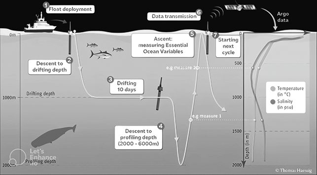
Figure 7.1 Long description
The illustration shows a boat and floating sensors on the ocean’s surface. Sensors are shown under the ocean up to a depth of 6000 metres, measuring salinity and temperature and drifting for a 10-day period. The illustration also shows a satellite above the ocean’s surface transmitting the data collected from the sensors. Three fish and a whale are also included in the depiction of the ocean.
The floats – made by different manufacturers and carrying different sensors – produce what is sometimes termed “raw data” about certain physical characteristics of the ocean, such as temperature and pressure.Footnote 30 Given the relatively circumscribed market for floats and sensors, researchers and manufacturers often collaborate in the development, testing, calibration, and customization of relevant instruments. Frictions can arise when instruments fail or produce flawed data, especially about whether the cash-strapped lab or the manufacturer will carry the loss or cost of replacement. A sensor malfunction on an already deployed float can be very costly, as floats are usually not recoverable for repairs or upgrades.Footnote 31
Although all floats are equipped with conductivity-temperature-depth (CTD) sensors, only some floats generate profiles of biogeochemical properties (BGC-Argo). In addition to CTD sensors, BGC-Argo floats can integrate sensors to measure chlorophyll fluorescence, particle backscatter, dissolved oxygen, nitrate, pH, and irradiance. The variability is partly a function of different scientific interests and needs and partly a function of launching parties’ capacity and availability of resources. Historically, except for oxygen, a single sensor was used for the other BGC variables. However, increasingly, for most of these variables there are different types of sensors available, some differing on measurement principles. Introduction of new sensors requires ensuring interoperability with float models and cross-sensor calibration to ensure standardized data output, which depends on the willingness of sensor manufacturers to share the necessary metadata among themselves as well as with float manufacturers and Argo scientists. Evaluation of new sensors may also require review of baseline standards: should the first integrated sensor be used as a reference point against which any new entrant is evaluated? Introducing new sensors also requires additional testing, but trials of sensors on floats is a slow and expensive process. Any minor malfunction (e.g., a failure in a trivial connector cable) can lead to loss of data, and since floats are difficult to recover, on-float testing is not an efficient proposition. In-lab testing requires specialized lab settings that enable sensor testing under controlled circumstances, but these are not very widely available.
7.2.2 Data Transmission, Location, and Control Infrastructures: Satellite Systems
To transmit and receive data, Argo relies on satellite infrastructures. The less time a float spends on the sea surface for transmission, the less vulnerable it is to external elements. The Iridium satellite system, which consists of sixty-six satellites at a height of approximately 781 km, can transmit more data within a shorter period of time than other satellite systems dating from the period prior to Starlink-like mega-constellations, because Iridium allows “data calls” to be relayed from one satellite to another until they reach the satellite that registers the float. Iridium also allows for two-way communication, making it possible to send instructions to the float for troubleshooting or for changing the float’s mission (e.g., a float can be redirected to observe a developing hurricane). In this way, Iridium is both a data transmission and control infrastructure.Footnote 32
Iridium, however, lacks the ability to geo-locate the floats. Hence, each float with an Iridium modem also includes a Global Positioning System (GPS) receiver to record the location of the float. A controller board on the float interfaces with the GPS receiver, the Iridium modem, the CTD sensors, and any other additionally installed sensors. The GPS receiver and the Iridium modem share an antenna that is connected to the radiofrequency circuit board, which serves as a platform for the GPS receiver, the Iridium modem, and any other communications devices.Footnote 33 Every additional instrument mounted on the float comes with a cost that is not purely financial: increased weight of the float, higher energy consumption, and shorter battery lifespan are tradeoffs and compromises that are often made through discussion among members of Argo. These shape not only what data is being generated but also who can generate it given capacity constraints.Footnote 34
Once on the surface, floats using the Iridium network perform a series of tasks in sequential order, with the floats creating their own temporality.Footnote 35 First, if a float is equipped with an oxygen sensor, it will collect in-air samples of dissolved oxygen. Second, it will acquire a position fix using GPS. This typically takes several minutes as the float establishes the connection with the GPS satellites and subsequently determines the position. Third, the float connects with an Iridium satellite and the Iridium gateway, logs on to the launching group’s data server, and queries the server for any changes that might be necessary in the mission configuration for the next profile. Lastly, the float transmits the profile (i.e., data collected from the water column during the float cycle), surface O2 samples, GPS, and engineering data (i.e., float diagnostic data), packaged into a series of highly compressed packets which are formatted according to Argo Data Management Team standards, via Iridium (for ways in which standards impact data production, see discussion infra, Section 7.3.1).Footnote 36 Due to interruptions in the transmission process, it is often necessary for the data to be transmitted several times before all data have been successfully uploaded.Footnote 37 On average, floats using Iridium spend twenty to thirty minutes on the sea surface for each cycle.Footnote 38
In the early days of Argo, almost all floats transmitted their data via the Système Argos – a location and data transmission system operated by Collecte Localisation Satellites based in Toulouse, France and Maryland, United States. Despite the similar name – both inspired by Greek mythology – Argo and Argos developed separately and at different times, although both were motivated by the desire to enhance opportunities for ocean observing. Argos satellites were initially developed as one-way, low-bandwidth satellites, with an effective data throughput of no more than 1 bit per second. In contrast to Iridium, Argos satellites have both data transmission and location data capabilities. However, Argos’ low data transmission rates required floats to spend between six and eighteen hours at the sea surface to ensure error-free data reception in all weather conditions. A later model (Argos-3) offers bidirectional transmission and a higher throughput, but the high-data-rate mode suffered from electromagnetic noise around Europe.Footnote 39 Some of the floats continue to use Argos satellites, and other satellite transmission systems have also been used on profiling floats, including transmission systems such as BeiDou in AsiaFootnote 40 and ORBCOMM in North America.Footnote 41
7.2.3 Data Processing, Storage, and Dissemination Infrastructures: Data Assembly Centers
Data is always stored somewhere (though not necessarily in one place) and needs to be processed and disseminated to render it accessible and useful for scientific knowledge production. Argo float data is transmitted via satellites to eleven national Data Assembly Centers (DACs) for processing, with each float being allocated to a specific DAC. Processed data from the national DACs is subsequently transmitted to two Argo Global Data Assembly Centers (GDACs) – one located at the Coriolis Data Center in France and the other at the US Navy’s Fleet Numerical Meteorology and Oceanography Center, where data is checked for format and content consistency.Footnote 42 Once per day, data holdings at the two Argo GDACs are being synchronized. The US National Centers for Environmental Information (NCEI) operates and manages the Global Argo Data Repository (GADR), which provides long-term archive services to store and preserve data and implements reanalysis updates and corrections provided by the GDACs.Footnote 43
The Argo Data Management Team (DMT) is responsible for coordinating data management and ensuring access to Argo data. The Argo DMT is composed of at least one representative of each institute involved in Argo data management activities.Footnote 44 DMT also defines Argo’s data management infrastructure, data formats, and quality control procedures.Footnote 45 There are numerous publicly available and regularly updated manuals, handbooks, and “cookbooks”Footnote 46 addressing all aspects of data processing for each parameter. The Argo data management teams aim to ensure not only that its data is openly available but that its potential users understand what data they receive. Argo data is made available from GDACs in the Common Data Format, a file format for storing multidimensional scientific data (variables such as temperature, humidity, pressure, wind speed, and direction).Footnote 47 All Argo data is publicly available without charge. Anyone can access Argo data via direct file transfer or via a World Wide Web interface. The digital data in this case rapidly becomes part of the public domain, not an accumulating private resource from which other well-funded scientists are excluded. It is not a form of club good in which non-contributors cannot get access.
7.3 Argo’s Data Infrastructure as Data Regulation
Argo is not a regimented enterprise in which infrastructure and data are forged together in an intentionally regulating unity or in decisive forms of public governance. At the same time, it is an infrastructure with potentially significant regulatory effects. As a data infrastructure, Argo determines what data is being produced by whom, where, when, how, and why, as well as what data is not being produced, which interests remain neglected, and where and when no data is being generated. What are the sites, processes, and interfaces where agency over these choices is exercised?
Despite a great deal of organization, labor, sustained effort, and resources that are required to produce reliable and usable data on a limited set of parameters, no single entity controls the whole infrastructure. The Argo Steering Team (AST) provides scientific leadership and oversees the development and implementation of the Argo Program,Footnote 48 but its control does not extend to each layer or capillary of the Argo infrastructure.Footnote 49 Argo forms part of the Global Ocean Observing System (GOOS),Footnote 50 whose operational arm (“OceanOPS”) acts as a focal point for implementation and operation of relevant observing platforms, monitors the Argo array, and liaises with the AST.Footnote 51 However, neither GOOS nor OceanOPS controls nor provides funding for the data infrastructure.
Argo has its own participatory governance, is embedded in other infrastructures with their own governance and legal regimes, and has close or distant links with many other scientific groups including climate modelers and some entities with governmental and commercial interests. AST annual meetings proceed rather informally and collaboratively, with decisions made by achieving some form of “rough consensus” without formal votes. When new issues arise and cannot be easily resolved, they can either lead to formation of ad hoc working groups whose task it is to study the issue and come up with recommendations, or they are assigned to certain people for follow-up and reports.Footnote 52 Argo participation and governance is emphatically not Mandeville’s fable of the bees – there is a great deal of public virtue as well as science- or funding-motivation in the Argo enterprise, together with a few shades of commercial and geopolitical interest. The whole process is organic and mycelial-like more than it is a planned and well-resourced realization of a grand vision and unified normativity.Footnote 53
In the following sections, we explore four interconnected dimensions of Argo data infrastructure governance practice that together shape what data is ultimately produced, for whom, and to what ends: infrastructural data inequality; spatial distribution of floats; temporal sampling of data; and efforts to cater (or not) to different publics, with implications for quality control and data diversification.
7.3.1 Infrastructural Data Inequality: Who Decides What Data Is (Not) Being Produced?
Who decides what ocean data is (or is not) being produced? Although the Argo array currently reflects contributions from thirty countries, significant forms of “data inequality” persist.Footnote 54 These inequalities reflect, at least in part, colonial legacies that led to the uneven distribution of oceanographic knowledge, as former colonial powers and dominant trading nations made significant historical investment in oceanography and associated technologies of ocean data generation, recording, and mapping.Footnote 55 In 2022, 80 percent of BGC-Argo float deployments were done by research labs from only three countries (US, France, and Canada), with more than 50 percent of the deployments by the United States.Footnote 56 Coverage for different parameters is uneven, with only a limited number of BGC-Argo floats carrying the complete suite of sensors (with 40 percent carrying only oxygen as the only extra sensor in addition to CTD). Overall sampling of the oceans is also unevenly distributed in Argo, with the Atlantic Ocean oversampled while the Indian, Pacific, and Southern Oceans remain undersampled.Footnote 57 Only nine countries participate in the Deep Argo array, with the United States, France, and Japan being leading national contributors. Some of the undersampled regions – such as the Southern Ocean – for many years were not the priority for main float contributors. As Dean Roemmich – one of Argo founders – noted in 2001, “[t[hat is one of the hardest implementation items for the Argo science team. In order to achieve a global array we will need to set some fraction of floats aside for a region that is not the top priority of any single government.”Footnote 58
Any decision on which data to produce must take into account technological and funding constraints and the interests of different communities. Expanding data production must be sensitive to the demands imposed on data managers, because additional sensors increase data complexity, which can require new standards, guidelines, and manuals.Footnote 59 Originally, Argo floats carried only CTD sensors. However, understanding the role of oceans in regulating climate change and, conversely, the impact of climate change on ocean ecosystems, requires observations of the ocean biogeochemistry. The Intergovernmental Panel on Climate Change’s Fifth Assessment Report listed temperature, salinity, acidification (pH), oxygen, nutrients (nitrate), and light as major drivers of ocean health. BGC-Argo introduced six new variables (oxygen, nitrate, pH, chlorophyll fluorescence, optical backscatter, and solar irradiance). The choice of these variables (and not others) was based not only on scientific research needs but also on availability of operational sensors.Footnote 60 Proponents of BGC-Argo acknowledged that specific scientific goals, regional issues, funding sources, and even sensor configurations may motivate different missions, requiring tradeoffs and compromises. For example, current radiometric sensors on BGC-Argo have four color bands available, which is not sufficient to characterize the spectral variability of the underwater light field and thus cannot capture the diversity of phytoplankton. Hyperspectral radiometry, which captures light over many wavelengths and enables recognition of tens or hundreds of colors, can enable better discrimination among different phytoplankton types, potentially improve knowledge of oceanic carbon stocks, pathways, and fluxes.Footnote 61 Enabling BGC-Argo with hyperspectral capability could also produce knowledge useful for the management of living resources and ecosystem services (e.g., habitat suitability, fish stocks, and recruitment) and for biohazard surveillance (i.e., harmful algal blooms).Footnote 62 Hyperspectral radiometric sensors, however, are more expensive, require more energy consumption, and impose additional labor costs for the Argo DMT. The working group on radiometry, created within the AST, recommended that those programs that have capacity move to hyperspectral radiometry but it could not mandate a wider adoption of the sensors.
Argo floats generate only some “ocean data” directly from the sensors (e.g., measuring temperature and electrical conductivity of the seawater sample); other data is derived from computations. For example, all Argo floats are equipped with CTD sensors. The “C” in CTD is conductivity, which measures how well a solution conducts electricity. Since dissolved salts and other inorganic chemicals conduct electrical current, conductivity increases as salinity increases. The measure of conductivity thus relates to the measures of salinity. However, salinity is also dependent on pressure and temperature. Whereas “T” measures temperature directly, “D” (depth) actually measures pressure. Using temperature and pressure, salinity can be derived via mathematical equations.Footnote 63 The density of water is calculated from temperature and salinity, and because pressure increases with increasing depth, depth can be derived in turn. Even with direct measurements, there are accuracy errors.Footnote 64 Sensor drift can introduce larger errors, requiring corrections by “experts,” which may entail comparing older floats with newly deployed instruments and with ship-based data.
Decisions of how to allocate limited resources – whether to invest in increase of spatial coverage, maintenance of Core Argo, enhanced longevity of floats, enabling more (up to six) BGC sensors on all BGC floats, expanding the reach and capabilities of Deep Argo, improving sensors to enable better data on specific parameters, or adding resources to the DMT – are discussed at annual meetings of the AST as well as at periodic meetings of various working groups formed to focus on specific issues or topics. Limitations and inequalities of funding are a recurring theme in these meetings. The phenomenon of underfunded infrastructures corresponds with broader insights from infrastructure studies that observe and sometimes lament the invisibility of infrastructures that are being “taken for granted” until their break down or fail.Footnote 65 Data infrastructures may be particularly susceptible to invisibility (as compared e.g., with physical infrastructures) because their failures and malfunctions are not immediately evident, even to those working directly with data processing and quality control. Errors may be revealed only when data is being validated by comparing it to other data sources (e.g., Argo data is often validated by data from the Global Ocean Hydrographic Investigations Program (GO-SHIP)) or when data from numerous floats is processed in the aggregate (e.g., to reveal a sensor drift). The value-added of the data infrastructure is also not immediately visible. Argo’s importance lies in having a reliable time-series data over substantial period of time, which enables comparative, historical, and predictive analysis of oceanic temperatures, for example. Yet, on a daily basis, Argo participants have to educate audiences, institutions, policymakers, and funders about the program’s importance and highlight new, potential, or previously unforeseen uses of Argo data in continuous efforts to sustain the program. Without sustained efforts at making Argo data infrastructure visible, Argo risks receding not only from public imagination but also from the gaze of those who supply information and knowledge that directly shapes earth systems governance. As a transnational infrastructure, Argo faces additional challenges that not only require international coordination but would also benefit from transnational cooperation in form of technology-transfers and capacity-building. Governmentally funded research, however, often remains stubbornly territorialized and hence misaligned with the transnational infrastructures necessary for planetary-scale science.Footnote 66
7.3.2 Infrastructural Space: Where Is Data (Not) Being Generated?
Argo seeks to generate ocean data on a planetary scale. Naturally, Argo’s floats cannot generate data everywhere as data generation depends on float location. In this way, data generation via floats differs from data generation via satellites. While the latter achieves planetary scale more easily by orbiting around the planet, the former manages to reach deeper into the ocean. In its originally proposed design, Argo was to comprise around 3,300 floats, each profiling the ocean between the surface and a depth of 2,000 meter around 25 times per year over an estimated lifetime of 3–4 years.Footnote 67 The OneArgo program aims to expand the spatial coverage of Core Argo while also increasing the number of BGC and Deep Argo floats. Given the significant financial and human resources involved in procuring, testing, and deploying the floats and processing subsequent data, tradeoffs and tensions arise along the way, shaping both the type of data that is produced and the choices about data’s target users and uses. By one estimate, given current life expectancies of floats, more than 800 floats per year would need to be deployed to develop OneArgo while maintaining the Core Argo array.Footnote 68 Funding remains a core challenge for maintaining and expanding the Argo program’s scale. However, spatial distribution is also impacted by natural phenomena, technical limitations, business models, and legal constraints.
Some areas of the ocean require more intense concentration of floats due to natural phenomena. For example, mesoscale variability in the Western Boundary Current regions require enhanced sampling to reduce noise in tracking the large-scale temperature and salinity fields.Footnote 69 One alternative to increasing float density is to increase the frequency of sampling. Another option is to rely on data provided by other instruments, such as glidersFootnote 70 or nonhuman species equipped with sensors,Footnote 71 to supplement Argo data. Both choices, however, impose costs associated with data generation, processing, and dissemination (e.g., additional processing to ensure standardization and interoperability of measurements).
Longevity of floats also impacts spatial coverage. Many floats are not recoverable (they can sink, get lost, be collected upon washing on shore and not returned to the owner, etc.) and thus cannot be repaired and redeployed. Areas with lower launch frequencies typically have older floats. Sufficient sampling would require increased float density to replace aging floats as well as to compensate for the original under-sampling. Increasing longevity of floats (and of their components), however, can be difficult both technologically and due to misalignment of incentives. Given the limited demand and supply of floats and sensors, manufacturers do not necessarily have incentives to prolong the life of the float and may need to balance demands for float longevity with demands from wealthier purchasers to enhance float capabilities or to customize floats.
Dependencies on a single producer or a limited group of producers aid in consistency of data and in implementation of uniform procedures for data processing across programs. However, such dependencies also create single points of failure: past incidents of faulty pressure and pH negatively impacted Argo coverage.Footnote 72 Greater diversification of sensor manufacturers would alleviate this problem but would also cause challenges relating to interoperability and data standardization.
Lastly, coastal areas remain undersampled due to uncertainties about whether Argo should be interpreted as “marine scientific research” under the UNCLOS.Footnote 73 Under Article 248 of UNCLOS, states or international organizations that intend to undertake marine scientific research within the exclusive economic zone (EEZ) or on the continental shelf of a coastal state are required to obtain that state’s consent, with typically a requirement of at least six-month advance notice describing the research project. Some states have agreed to deployment of Argo floats in their EEZs under the conditions of free and unrestricted data exchange and the transparent implementation through OceanOPS monitoring (a joint World Meteorological Organization (WMO)–Intergovernmental Oceanic Commission (IOC)/UNESCO Support Center for oceanography and marine meteorology). Other coastal states reportedly do not consider Argo to be “marine scientific research” and hence allow float deployment without consent.Footnote 74 Yet other states maintain the position that every float deployment needs to comply with Article 248. Thus, as a practical matter, deployment of Argo floats within EEZ is arranged on a bilateral basis. However, because there is no articulated procedure for “clearing” marine scientific research projects, compliance with Article 248 is cumbersome and deployment of floats in EEZs is often avoided.Footnote 75 This leads to significant under-sampling, given that EEZs represent nearly 30 percent of the world’s ocean surface.
7.3.3 Infrastructural Time: When Is Data (Not) Being Generated and Transmitted?
Argo generates a set of synoptically sampled time-series data that enables ongoing analysis of ocean parameters, over-time comparisons not only over the course of Argo tenure but also retroactively,Footnote 76 and forward-looking forecasts, models, and predictions. The timeliness of data generation and transmission are important infrastructural decisions that affect different scientific communities in different ways.
Fluorescence observations obtained as a measure of phytoplankton mass, for example, are best done at night. In contrast, assessment of biomassFootnote 77 using radiometry and comparison of BGC-Argo sensor results to satellite remote sensing motivates measurements around noon.Footnote 78 When manufacturers set the default for the floats to come up at noon, they put an onus on operators to alter the setting as needed. Lack of standardized guidance on the timing of sampling can create challenges for data comparability. The Argo Steering Committee and the Argo DMT deliberated on whether to adopt a sampling frequency of 10.2 days (245 hours) to ensure profiles are not taken at the same time each day. This compromise ensures temporal compatibility of measurements across the array but potentially comes at the cost of not optimizing data of particular interest for specific research communities (e.g., those interested in phytoplankton might want all data to be sampled at night).
Measurement of oxygen also poses challenges on temporal scales. Oxygen sensors can be used to measure both changes in global ocean oxygen inventories and local biological activity. Changes in the whole-ocean oxygen inventories, however, are expected on decadal timescales, necessitating sustained array observations and significant commitment to sensor stability assessments. In contrast, net community production measurements (i.e., gross oxygen production minus oxygen consumption by all organisms), especially if they are to be scaled to satellite remote sensing of biomass, require high temporal and spatial frequency observations. This is because oxygen levels shift throughout the day due to changes in photosynthesis, which rises through the day and falls to zero at night.Footnote 79 Frequent sampling increases energy consumption, which may decrease the longevity of the float.
At the time of its founding, the Argo program aimed to meet the requirements of operational oceanographers (i.e., weather monitoring and forecasting) on the one hand and the scientific community engaged in climate monitoring and modeling on the other hand. These two communities and research agendas demand different kinds of data on different time scales. Operational oceanographers need access to Argo data as soon as possible, even if the data is not of the highest quality. In contrast, for climate monitoring and modeling communities, the quality of data is of paramount importance. To meet the objectives of the two communities, Argo’s designers decided to make vertical profile and trajectory data available in “real-time” and in “delayed-mode.”Footnote 80 “Real-time” data is not immediate or continuous but is provided within twenty-four hours of satellite transmission and is subjected to a set of automatic quality tests, which assign “quality flags” to grossly “bad” data. Flagged data is preliminarily adjusted and both the original and the adjusted data are subsequently inserted into the Global Telecommunications System (GTS) used by operational meteorological agencies. In contrast, delayed-mode data is typically made available within a year (or more) after transmission. The quality control for delayed-mode data involves a combination of human expert review (e.g., data is visually examined by oceanographic experts for additional (re-)flagging) and complex statistical processes.Footnote 81 In these ways, Argo creates different kinds of data depending on when data is being generated, when data is being processed, and when it is being made available. These different kinds of data correspond to the needs of diverse scientific communities, or: Argo’s infrastructural publics.
7.3.4 Infrastructural Publics: Scientific Communities and Beyond
Infrastructures generate publics.Footnote 82 Argo’s foundation and trajectory as a data infrastructure that is mostly, but not exclusively, used by various scientific communities informs many of the contests about what data is being produced, when, where, how, and for whom.
Argo operates as a self-defined community that formed around the creation and operation of the Argo infrastructure. Argo’s trajectory has been shaped by dedicated scientists, many of whom have been deeply involved since the program’s inception. Their priorities are animated by the sensibilities of scientific practices and the desire to ensure that users of the data understand what the data represents and what its limitations are, with outermost attention placed on the quality and consistency of data.Footnote 83 The proposal for the array, put forth in 1998 by a US oceanographer from the Scripps Institution of Oceanography, Dean Roemmich, found resonance with the climate research interests of the Climate Variability and Predictability (CLIVAR) ProgramFootnote 84 and the operational estimation objectives of the Global Ocean Data Assimilation Experiment (GODAE).Footnote 85 Inheriting the legacies and technologies of prior ocean observation infrastructures, Argo founders aimed to develop a program that would respond to the needs of meteorologists and climate modeling communities. The incorporation of Argo into GOOS further entrenched these twin goals,Footnote 86 and the incorporation of Argo into the priorities of the Ocean Decade envisioned further uses and users of Argo data, including via aggregation with data from other sources and infrastructures.
Fulfilling the needs of different communities, however, presents challenges. Scientific communities deploy different methodologies,Footnote 87 pursue divergent political priorities,Footnote 88 and encounter variegated funding and organizational problems.Footnote 89 To date, neither GOOS nor the IOC provide funding for Argo (or any other ocean observation network), but instead aim to standardize and systematize what knowledge about the ocean is being produced transnationally and for what purpose.Footnote 90 Securing funding for Argo hence remains a recurring challenge for the Argo community.
In a quest to ensure its sustainability and in response to growing demand for Argo data from diverse scientific communities, Argo’s data infrastructure is constitutive of and responsive to diverse infrastructural publics.Footnote 91 Scientific communities interested in operational ocean science and related modeling, for example, are affected when Argo’s data is being updated, including retroactively. To better connect with these operational and modeling communities through regular information exchange and communication, the AST created a regular virtual forum for Argo and ForeSea/OceanPredict.Footnote 92
The rarity of having consistent time-series of ocean observations has made Argo infrastructural not only to its intended users (i.e., operational oceanographers, climate modelers, etc.) but also to those who see Argo as a foundation upon which additional types of data can be generated. In this way, Argo’s spatial and temporal data generation can generate new publics, or re-make existing publics. For example, Argo’s success in creating observations of ocean’s interior at “adequate temporal and spatial scales” prompted scientists to note that there were no similar advances in observations of large-scale biogeochemical and biological states of the ocean.Footnote 93 The only program mapping out the distribution of biogeochemical tracers in the ocean had been the global CO2 survey undertaken jointly by WOCE, the Joint Global Ocean Flux Study (JGOFS), and a few other national groupings – that program took a decade to complete, and was largely a one-time snapshot, providing limited information about evolution over time. The Repeat Hydrography program suffered from similar temporal challenges, with about a decade between repeats of hydrographic sections.Footnote 94 Although such temporal sampling was adequate for determining the long-term increase of the oceanic carbon content in response to the increase in atmospheric CO2 levels, it was incompatible with the seasonal to sub-decadal timescale of variability in many biogeochemical parameters within the transition layer between warmer mixed water at the surface and cooler deep water.Footnote 95 In 2007 it was proposed that oxygen sensors be added onto Argo floats. While this proposal was being considered, contemporaneous developments in sensor technologies for oxygen, chlorophyll, particles, and nitrate had enabled the deployment of sensors on long-endurance missions on autonomous platforms.Footnote 96 This, in turn spurred the creation of BGC-Argo – a program that would see floats carry not only oxygen sensors but other biogeochemical sensors as well, bringing into the collaborative fold of this Argo program various BGC modeling communities, along with the physical ocean data assimilation community.Footnote 97
The introduction of BGC sensors and the expansion of the originally intended Argo users, however, have introduced new challenges in determining what constitutes “bad” data and based on which criteria “flagging” of such data should occur. For example, bio-optical sensors provide proxy information on the size structure of the phytoplankton assemblage, which are responsible for about half of the biological uptake of CO2 on Earth through photosynthesis.Footnote 98 The light from bio-optical sensors, however, often attracts larger mid-water organisms, creating “spikes” in data that would be typically flagged as “bad” or “probably bad” data since it is not the type of data expectedFootnote 99 from the sensors. However, this data could be useful to scientists interested in tracking migrating organisms that live in the mesopelagic zone of the ocean (e.g., zooplankton, fish, squids, and jellyfish).Footnote 100 The eventual compromise arrived at during the 2023 meeting of the AST was to retain the automated flagging of “bad” or “probably bad” but provide an index file of profiles or data segments that are believed to contain signals of mesopelagic organisms.
Building synergies with other “communities” continues to be a strategy for the Argo program as it struggles to secure consistent and reliable funding. At the AST meeting in March 2023, discussions focused on potential collaboration with other “communities” that could benefit from Argo data and that have access to funding,Footnote 101 such as “ocean color” communities that use satellite-based remote-sensing infrastructures to monitor health of the oceans and entities and collectives focused on marine carbon dioxide removal (CDR). Diversified uses of Argo data can enrich outcomes of other knowledge infrastructures (e.g. providing the “vertical dimension” for validating satellite data)Footnote 102 while also making Argo more relevant and sustainable by creating dependencies with a broader array of users (e.g., Argo’s oxygen monitors may become indispensable to CDR projects).
At the same time, the expanded user base can lead to changes in the type of instrumentation and data, creating interoperability issues and requiring additional resources for the DMT, thereby posing governance challenges. Additionally, as data infrastructures expand or are being repurposed, contests over their normative orientation may emerge. Consider, for example, discussions at the AST meeting in March 2023 on potential collaboration with CDR projects. Should BGC-Argo act as a neutral “referee,” independently evaluating the effects of ocean manipulation associated with CDR on oxygen levels and ecosystems? Such a role would expand uses of Argo data but would not give Argo access to funding associated with CDR initiatives. Or should Argo collaborate with those involved in CDR to open up funding opportunities for Argo? Such an endeavor would implicate the Argo community in an activity that might not normatively align with its members’ priorities and expectations, and might lead to unforeseen externalities.Footnote 103
Argo’s infrastructural publics also interact with legal publics (states) and their representatives (governments),Footnote 104 as they fund, support, coordinate, prioritize, and otherwise contribute to the array. More attenuated but nonetheless affected publics are the individuals and communities that experience extreme weather conditions and the impacts of climate change and for whom weather and climate forecasts (or absence thereof) can have existential implications.
Given the “openness” (in the sense of public accessibility without charge) of Argo data not all of the data infrastructure’s publics may be immediately evident and some may be unintended. The tenor of Argo is one of scientific knowledge production – chief impacts touted by Argo members and documented by states in national reports are the number of scientific publications using Argo data. Yet data produced through BGC sensors is relevant for fisheries management,Footnote 105 and variability of temperature and salinity with depth contributes to understanding the structure of the sea for the purpose of submarine warfare.Footnote 106
Argo also engages nonhuman publics – the species and organisms of various sizes inhabiting different layers of the ocean and unwittingly “collaborating” (in a Latourian sense)Footnote 107 with the floats and their instrumentation to generate data about themselves (e.g., as in when migrating organisms are attracted to the light sensors to “reveal” their presence to observing scientists), subverting Argo’s mission by “polluting” the data or damaging the floats, or complementing and validating Argo data (e.g., where sensor-carrying animals are used to verify or supplant Argo data). The interests of the nonhuman publics are not really recognized or represented in the Argo data infrastructure, however, except insofar as their datafied representation becomes relevant to the expanded base of users of the Argo data infrastructure (e.g., those concerned with biodiversity conservation or species preservation).
7.4 Observational Science Data Infrastructures in Planetary Governance
Argo’s development and its positioning within the institutional governance of oceans, weather, climate and, most recently, earth systems, reflects tensions in different understandings of what is to be governed, by whom, for whom, and how. Responding to the challenges of observing something so vast and dynamic as oceans,Footnote 108 Argo was initially designed to match observations of the ocean sea level obtained from the satellite altimetry project Jason.Footnote 109 In the early nuclear and space era, efforts to institutionalize transnational data collection, buoyed by collaborative research during the International Geophysical Year (1957–58), led to establishment of the IOC in 1960 under the auspices of UNESCO and ultimately the creation of the Integrated Global Ocean Station System (IGOSS) whose aim was to collate regular observations from ships, buoys, and satellites about tides, temperatures, storm surges, and other oceanographic information. IGOSS, together with the International Oceanographic Data and Information Exchange program (IODE), subsequently became building blocks for a GOOS – a global coordination network aimed at creating a “global ocean observing system that delivers the essential information needed for our sustainable development, safety, wellbeing and prosperity.”Footnote 110 GOOS envisions an integrated global infrastructure that brings together a wide range of ocean observation data from different sources, including satellites, moored instruments, research vessels, gliders, animal-borne sensors, and autonomous surface and under-surface floats.Footnote 111 Globality in this context appears animated not only by the vision of international collaboration but also by the imaginary of one “global” ocean.Footnote 112
This imaginary found prominence in the framework for the United Nations Decade of Ocean Science for Sustainable Development (2021–30) (“the Ocean Decade”), proclaimed by the United Nations General Assembly in 2017. The Decade was officially launched in 2021 and announced itself as envisaging “nothing less than a revolution in ocean science that will trigger a step change in humanity’s relationship with the ocean.”Footnote 113 The Implementation Plan described seven outcomes for the “ocean we want” at the end of the Ocean Decade, each ascribing features to the anthropocentric image of a global object: “clean ocean,” “healthy and resilient ocean,” “productive ocean,” “predicted ocean,” “safe ocean,” “accessible ocean,” and “inspiring and engaging ocean,” to be managed, understood, exploited, protected, and valued by humans-as-distinct subjects.Footnote 114 Two of the ten challenges identified as objectives for the Ocean Decade to help meet specifically included ocean observations and data: expand the GOOS (Challenge 7) and create a digital representation of the ocean (Challenge 8). The aim was – in the rhetoric of that moment – to create an all-known-at-all-times-past, present, and future-everywhere-to-everyone global ocean.Footnote 115
The IOC data and information strategy for the “ocean decade,” issued in 2023, called for a shift “towards ‘data-first’ resource mobilisation.”Footnote 116 It envisaged the creation of a federated digital ecosystem that will “build on what already exists, including ongoing data strategies and existing infrastructures” to allow users to combine data from diverse sources, across disciplines and geographic boundaries “as frictionless as possible.”Footnote 117 Notwithstanding the mobilization being driven by decadal temporality, the strategy aimed for the resulting “digital ecosystem” to be sustainable “for years to come.” This rhetoric is stunning not only in its naiveté but also in its deployment of “ocean data” as a given ontological phenomenon. The strategy’s use of the term “ecosystem” echoes the presumption that “ocean data”Footnote 118 exists in nature and that the problem for ocean management and governance, including climate, fisheries, and biodiversity management, is one of epistemology: if only all the “ocean data” were accessible and interoperable, it will be known how to answer questions such “Where should a local fisher go today? Where should a marine protected area be placed? Where should infrastructure (e.g. wind farms, resilient shorelines, deep-sea cables) be developed? Is it safe to go to the beach today? What routes should ships take to avoid cetaceans or use less fossil fuels?”Footnote 119
Earth systems approaches had already come to feature in many institutionalized initiatives of planetary governance. As early as 2014, the Secretary General’s report to the UN General Assembly embraced Earth system science, whose “holistic scientific knowledge” paved the way toward earth system governance: “both Earth system science and Earth system governance continually and mutually reinforce each other regarding a holistic vision for the planet.”Footnote 120 The World Meteorological Congress had promulgated a concept of “earth” as “an integrated system of atmosphere, ocean, cryosphere, hydrosphere, biosphere, and geosphere, which informs policies and decisions based on a deeper understanding of the physical, chemical, biological and human interactions that determine the past, current and future states of the Earth.”Footnote 121 The fundamental importance of oceanic-atmospheric interactions to climate modeling and to earth system governance had by then brought Argo and cognate data-knowledge infrastructures into the purview of the climate change regime. Political as well as scientific effort has increasingly focused on what more is needed to build out comprehensive and systematic earth observation gaps for ocean, mountain, desert and polar regions, and the cryosphere.Footnote 122 If the details of the Argo program have thus far attracted interest mainly from its users and a small band of others, Argo has begun to seem of much wider importance.
The Argo program has been embraced as one of GOOS’ global observation networks,Footnote 123 with aspirations – under the label “OneArgo”Footnote 124 – to expand its global coverage, extend its span to full ocean depth, add biogeochemical sensors for improved understanding of cycles of carbon and nutrients, as well as ecosystems, and consider additional sensors that might be included in the future. Argo’s role has thus come to appear increasingly central not only in weather forecasting and climate modeling, but also as a component of aspirational planetary data infrastructure. Given Argo’s resilience and relative success in sustaining infrastructure for the production of high-quality data, albeit on limited parameters, is also likely to become a model for other networks under GOOS and beyond. Like mycelium, Argo may compose a mycorrhizal networkFootnote 125 that connects (via interoperability or gateways) diverse data infrastructures to enable exchanges and aggregations of different types of planetary data, or split off fragments of itself to give life to other independent networks.
7.5 Conclusion: Toward Organic Data/Infrastructure Governance?
Our account of Argo illustrates what it takes to produce useful data about oceanic properties. The program operates under significant capacity constraints. In its quotidian practice, Argo is a product of individual flair and initiatives, lock-in to past practices for data continuity, and the quirks and vagaries of funding and participation, as well as external overlaps of interest. High politics figures only episodically and usually at some remove within and around Argo practices about who decides what data is being produced, by whom, how, and for what purpose, where, and when. The different kinds and functions of data that are being generated, transmitted, processed, stored, and disseminated owe much to these features.
We cannot know what Argo’s ultimate contribution will be to the global governance of the ocean, as institutions and frameworks that aim to pivot toward earth system or planetary governance are still in their incipient stages, and headwinds will abound. Our analysis suggests assessing with considerable caution those grand unifying framings that treat each oceanic observation platform as a needlessly separate project requiring macro-level coordination to connect with others into a large-scale, integrated observation systems.
Overemphasizing this coordinative approach may underestimate the imperatives of concrete funding and maintenance needs within existing infrastructures, and runs some risk of entrenching early choices and tradeoffs without sufficient awareness and ongoing responsiveness to their cascading impacts on different infrastructural publics. Such unified structures may neglect (or even impede) the quirks and serendipities in the continued formation of organic connections between different producers of data, knowledge, and unexpected new insights: about the oceans, its ecosystems, and inhabitants, as well as about many different elements of earth systems. A collation of “ocean data”-producing infrastructures, if not done very thoughtfully, may risk producing highly contingent representation of the oceans, their properties, inhabitants, and ecosystems, while reifying the “global ocean” as a bounded anthropocentric object of governance that can be made manageable, predictable, and sustainably exploited for human consumption. Integrating “what exists” and silo-ing earth system components into contingently constructed objects inevitably marginalizes alternative (e.g., Indigenous) approaches to planetary governance that emphasize interactions of (eco)systems, species, and nonliving entities, as well as the historical and cultural significance of oceans.
Not every infrastructure follows (or should follow) the classical trajectory of large-scale network consolidation that Thomas Hughes described for London’s electric grid.Footnote 126 Data infrastructures, with their constituencies whose kaleidoscopic interests range across many forms of knowledge, often develop organically – like a mycelial network that extends and sprouts in valuable but not predetermined ways.Footnote 127 Data infrastructure governance, by extension, particularly in planetary science contexts, requires an alertness to the circumstances of organic (i.e., without global-scale central scheme or planning) data infrastructure development. These include the unevenness, choices, inequalities, and steep gradients of power which almost inevitably characterize such infrastructures because of the distribution of resources and capacities in the knowledge-generating projects that undergird them.
Argo has been carefully nurtured by various scientific communities that coalesced around Argo as a “data infrastructure.” Over time it has become increasingly and successfully linked to other oceans-data and planetary-data initiatives and framings, and this growth in linkages can be expected to continue and deepen. However its importance in current and future planetary-scale ocean data governance, do not equate to a need for it to be subordinated into a hierarchical planetary-scale governance for earth systems knowledge and policy structure. We ourselves are not in a position to judge, though it appears at least likely that Argo may thrive and contribute optimally, as a sprouting network that spreads out organically, creating unexpected connections and even fusions when interacting with other initiatives. Our study indicates that this modality continues to have much to offer in the development of data and knowledge of planetary importance.Footnote 128

 Open access