


Introduction
The Thick-billed Parrot Rhynchopsitta pachyrhyncha is an endangered, obligate cavity-nesting psittacine endemic to the high-elevation pine forests of Mexico’s Sierra Madre Occidental. Formerly ranging into southeastern Arizona and southwestern New Mexico, the species was extirpated from the USA by 1938, probably because of unregulated shooting (Lanning and Shiflett Reference Lanning and Shiflett1983, Moretti Reference Moretti2022). Today, the species persists only within the increasingly fragmented montane forests of northwestern Mexico, where populations breed (Jun–Oct) primarily in the states of Chihuahua and northern Durango, then overwinter (Nov–May) within the south-central reaches of the Sierra Madre Occidental (Sheppard et al. Reference Sheppard, Cruz, González, Nieto, Swaisgood and Lamberski2023). Listed as Endangered by the IUCN and in Appendix I of CITES, the Thick-billed Parrot now numbers only c.2,500 individuals in the wild (U.S. Fish and Wildlife Service 2013).
Threats facing Thick-billed Parrot populations are multifaceted and intensifying. Nesting cavities have declined sharply following intensive logging of remnant old-growth forest, of which only ~1% remains in the Sierra Madre Occidental (Monterrubio‐Rico et al. Reference Monterrubio-Rico, Charre-Medellin and Sáenz-Romero2015). Anthropogenic pressures are being compounded by higher incidences of wildfires exacerbated by drier conditions and prolonged droughts driven by climate change, which also threaten parrot forage productivity and nesting resources (Sáenz-Romero et al. Reference Sáenz-Romero, Rehfeldt, Crookston, Duval, St-Amant, Beaulieu and Richardson2010). Recent increases in predation events are also impacting the species’ recovery (Sheppard et al. Reference Sheppard, Rojas, Cruz, González, Nieto and Lezama2021).
Despite its conservation importance, empirical knowledge of Thick-billed Parrot ecology remains limited, hampering evidence-based management. This knowledge gap is particularly acute with respect to the species’ spatial behaviours. The first tracking study of wild Thick-billed Parrots by Sheppard et al. (Reference Sheppard, Cruz, González, Nieto, Swaisgood and Lamberski2023) revealed that these parrots are seasonal migrants, undertaking range shifts of up to 765 km between ranges, with most movements occurring between Oct–Apr. However, almost nothing is known about its non-breeding season distribution when these birds disperse into remote, inaccessible, poorly-surveyed regions. We report on the first formal identification, characterisation, and ground-truthing of the non-breeding (overwintering) range habitat and southern population-level home range of the Thick-billed Parrot.
Methods
The location and dimensions of the overwintering range were inferred from biotelemetry data for 78 wild parrots tracked from northern nesting grounds during 2019–2025 (Sheppard et al. Reference Sheppard, Cruz, González, Nieto, Swaisgood and Lamberski2023). Tracking data were processed using established quality‑control pipelines (Jonsen et al. Reference Jonsen, Grecian and Patterson2023; Langley et al. Reference Langley, Lang, Ozsanlav-Harris and Trevail2024) and restricted to an overwintering window (mid‑Nov to mid‑Mar) that brackets the period of stable non-breeding residency, after southbound migration is complete and before northbound pre-breeding movements initiate (Sheppard et al. Reference Sheppard, Cruz, González, Nieto, Swaisgood and Lamberski2023), and excludes transit locations that would otherwise inflate home-range estimates. No individual was tracked across the full 2019–2025 period, so the number of active tags and the winter sample size varied among years. Winter locations were analysed using continuous‑time movement models (CTMM) to estimate individual home‑range utilisation distributions with autocorrelated kernel density estimation (AKDE) (Calabrese et al. Reference Calabrese, Fleming and Gurarie2016; Fleming and Calabrese Reference Fleming and Calabrese2017; Fleming et al. Reference Fleming, Deznabi, Alavi, Crofoot, Hirsch and Medici2022). Because fewer than 50 winter locations produce unstable variograms and unreliable AKDE estimates, we restricted the analysis to the 42 of 78 tracked birds that met this threshold. Retained individuals had a mean of 196.2 ± 16.3 (SE) winter locations per bird (range 60–561). We then derived a population‑level mean utilisation distribution and intersected it with elevation, forest cover and land‑cover layers from standard remote‑sensing products to characterise habitat within the overwintering range (Gorelick et al. Reference Gorelick, Hancher, Dixon, Ilyushchenko, Thau and Moore2017; Hansen et al. Reference Hansen, Potapov, Moore, Hancher, Turubanova and Tyukavina2013; INEGI 2021).
Results
Although tagged birds moved in multiple subflocks (spatially and temporally distinct subgroups of co-occurring individuals) with per-individual winter ranges spanning several orders of magnitude (<0.001 to 0.84 km²), their collective space use converged on a well-defined population-level overwintering range located in the Sierra Madre Occidental of northwestern Mexico, primarily in western Chihuahua and adjoining Durango and Sinaloa. This range lies 380 to 570 km south of the northern breeding range and spans roughly 27–29°N, 107–109°W. The 75% AKDE contours of the overwintering range encompass a compact core and surrounding buffer of high‑elevation montane coniferous and mixed pine–oak forest on dissected ridgelines and upper slopes, embedded within the broader canyon‑and‑plateau landscape (Figure 1, Table 1). This core range occupies cool, high‑elevation terrain mostly between about 2,200 and 2,900 m above sea level and experiences mean annual temperatures of roughly 13–18 °C. Mean annual rainfall is about 500–1,000 mm, most of which falls during the summer monsoon season (Silva-Flores et al. Reference Silva-Flores, Pérez-Verdín and Wehenkel2014). Only 10% of the overwintering home range habitat area is currently covered by formal regulatory protection (dropping to 0.4% for the 75% home range utilisation distribution contour, Figure 1). These seasonal range shifts closely mirror post-release movements observed during the 1980s–1990s reintroduction trials in southeastern Arizona, in which released birds migrated north to breed and returned south post-breeding, and a VHF-tracked cohort subsequently left the release area as a coordinated flock (Snyder et al. Reference Snyder, Koenig, Koschmann, Snyder and Johnson1994). Subsequent translocation work within Mexico has shown similar patterns (U.S. Fish and Wildlife Service 2013), indicating that such movements should be anticipated and integrated into the spatial and temporal planning of future Thick-billed Parrot reintroductions.
AKDE population-level CTMM overwintering home range contours for Thick-billed Parrots Rhynchopsitta pachyrhyncha. Left: Full overwintering home range showing geographic context in northern Mexico as well as approximate historical range extending into the southwest USA and known existing nesting sites. Right: Closeup of the inner 50% (yellow) and 75% (orange) home range contours overlaid across the high-elevation pine and mixed pine-oak forests of the Sierra Madre Occidental ecoregion (green shading). Purple polygons indicate habitat protection zoning, with only 0.4% of the 75% home range contour covered by formal regulatory protection: Cerro Mohinora (Área de Protección de Flora y Fauna) in the north and Cuenca Alimentadora del Distrito Nacional de Riego 043 Estado de Nayarit (Área de Protección de Recursos Naturales), both federal protected areas administered by CONANP (CONANP 2024).
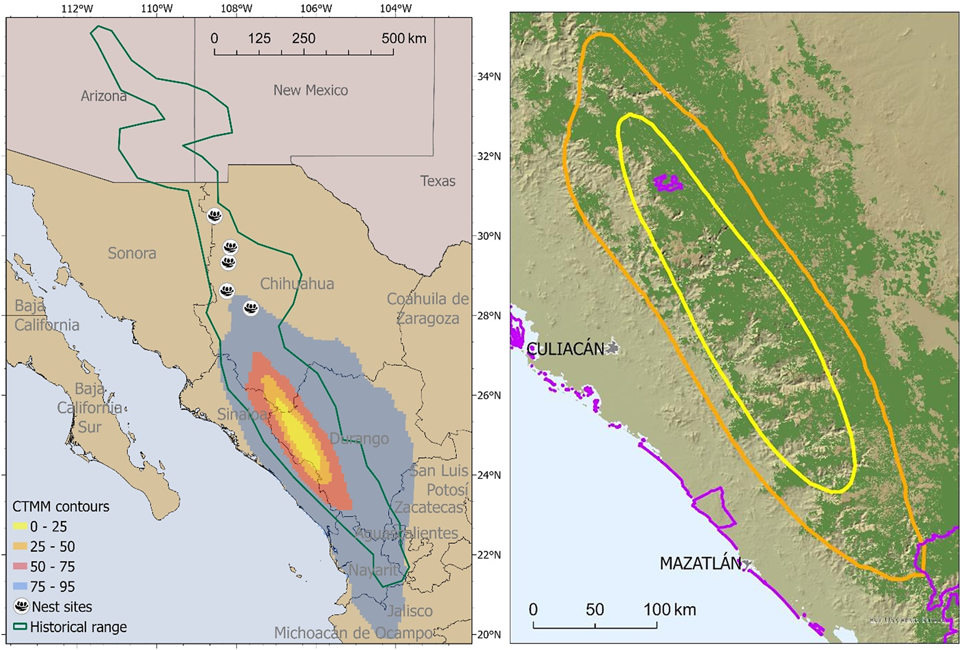
Figure 1. Long description
A two-panel map display.
Left panel: A large-scale map of northern Mexico and the southwestern United States. A green outline marks the historical range, extending from Arizona and New Mexico south through the Sierra Madre Occidental. Five nest site icons are clustered in western Chihuahua. Overlaid on the states of Sinaloa and Durango are shaded C T M M contours. At the core is a yellow region (0 to 25), followed by orange (25 to 50), red (50 to 75), and a broad blue perimeter (75 to 95). A scale bar at the top indicates 0 to 500 kilometers.
Right panel: A high-resolution topographic closeup of the core overwintering area. The background shows green-shaded forest cover across the Sierra Madre Occidental. Two concentric oval contours are centered over the mountainous terrain: an inner yellow line representing the 50 percent home range and an outer orange line representing the 75 percent home range. Small purple polygons indicate protected areas. One purple zone is located inside the northern section of the yellow contour, and another is at the southern edge of the orange contour near the coast. The cities of Culiacán and Mazatlán are labeled on the coast to the west. A scale bar at the bottom indicates 0 to 100 kilometers.
Summary statistics of the population-level overwintering seasonal home ranges for tracked Thick-billed Parrots derived from CTMM AKDE dimensions. Basic forest cover values are included for each AKDE contour.

Table 1. Long description
The table consists of six columns and three data rows. The columns are labeled: A K D E contour, Area in km super 2, Elev mean in m plus or minus S E, Canopy cover mean in percent plus or minus S E, Pine percent, and Pine-Oak mix percent.
* Row 1 (25 percent contour): Area 6912; Elevation 1756 plus or minus 4.3; Canopy cover 53 plus or minus less than 0.01; Pine 35 percent; Pine-Oak mix 18 percent.
* Row 2 (50 percent contour): Area 18725; Elevation 1719 plus or minus 0.2; Canopy cover 51 plus or minus 0.01; Pine 35 percent; Pine-Oak mix 16 percent.
* Row 3 (95 percent contour): Area 201464; Elevation 1106 plus or minus 0.1; Canopy cover 26 plus or minus 0.14; Pine 21 percent; Pine-Oak mix 15 percent.
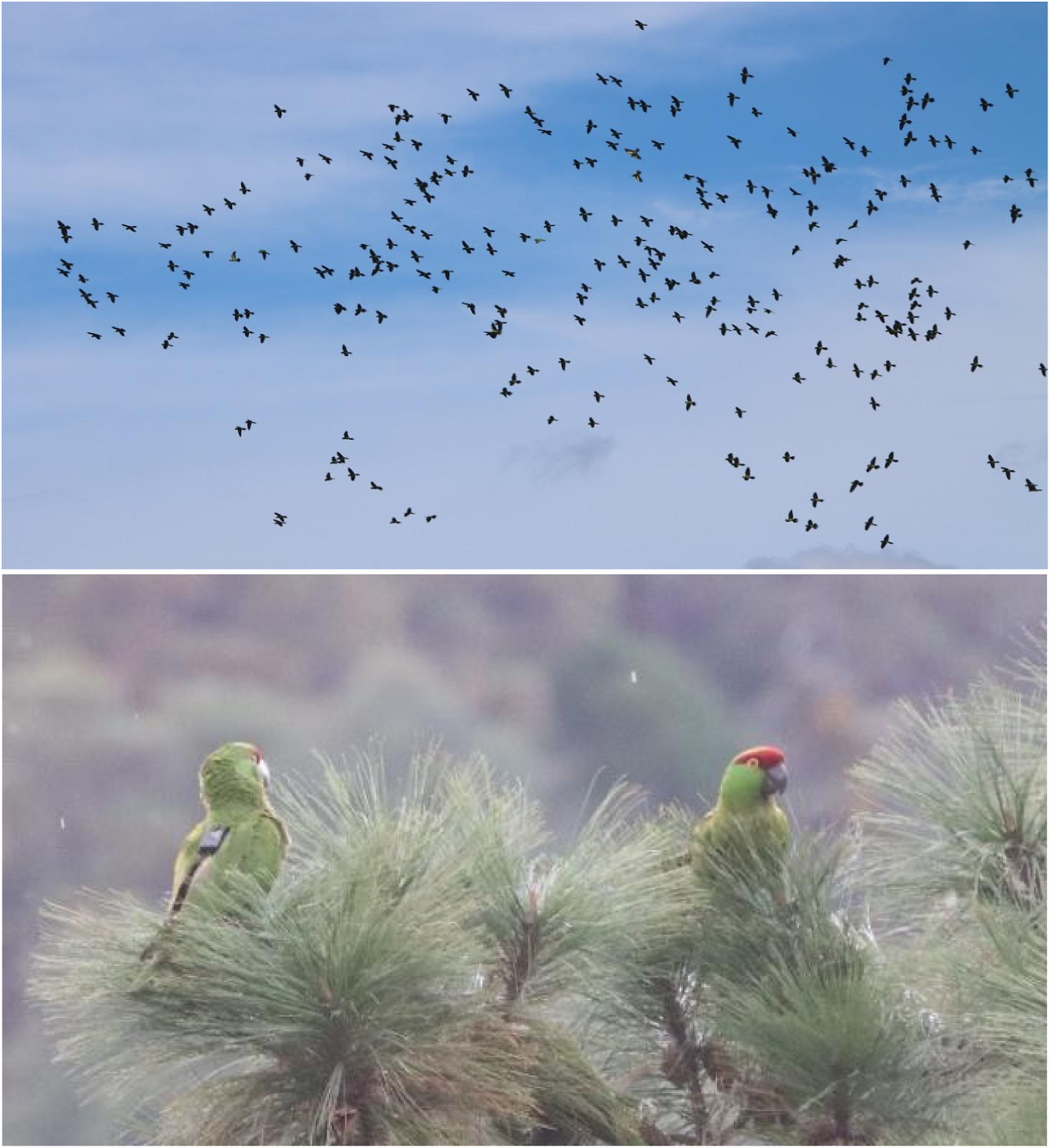
We conducted an expedition into the overwintering range in 2026 (21–23 and 28 Jan) to ground‑truth and validate the tracking data and home range estimate, confirm the presence of overwintering thick‑billed parrot flocks, and characterise the seasonal habitat of the species through direct observations. We accessed c.35,000 hectares of these remote, high‑elevation Sierra Madre Occidental sites using four wheel drive vehicles, and documented intensive use of core habitats by large flocks of wild parrots estimated at 300–900 individuals (Figure 2). Three observation points were selected from recent transmitter locations to maximise flock detections while remaining at least 5 km apart. Site choice also considered accessibility and security, and dawn/dusk counts were timed to exceed minimum flight times between sites, preventing overlap. Forests within these overwintering sites were dominated by pine species, notably Pinus durangensis, Pinus cooperi, and Pinus teocote.
Top: Previously unrecorded large flocks of Thick-billed Parrots Rhynchopsitta pachyrhyncha were confirmed by direct observations in remote overwintering habitats. Bottom: Parrots telemetered at their northern nesting sites were observed within these southern flocks (note the backpack-mounted transmitter attached to the parrot on the left).
Discussion
Our observations validate the tracking-based spatial predictions and reveal larger flock sizes than previously reported, indicating that the current estimate of c.2,500 wild individuals may be conservative and should be reassessed through systematic range-wide surveys. They also highlight the conservation importance of these largely unprotected overwintering sites and provide key information to refine habitat‑protection priorities across the species’ seasonal range. The Ejidos (communal landholding communities) that co-occur with overwintering parrots maintain landscape management plans that include agriculture, grazing, and forestry; logging is presently carried out under regulated, ostensibly sustainable forestry agreements and appears to maintain sufficient key foraging or roosting trees. Nevertheless, these habitats warrant close monitoring for impacts from illegal logging, bark beetle outbreaks, and increasing incidences of wildfire and drought associated with climate change (Salinas-Moreno et al. Reference Salinas-Moreno, Ager, Vargas, Hayes and Zúñiga2010; Ruacho-González et al. Reference Ruacho-González, Corral-Rivas, González-Gallegos, González-Elizondo, López-Serrano and Briseño-Reyes2025). Additional key sites should be secured through agreements with forestry communities, including recognition as Other Effective area‑based Conservation Measures (Brodie et al. Reference Brodie, Deith, Burns, Goetz, Cunningham and Hill2025).
Data availability
The tracking location data used in this study are archived in the Movebank data repository (Study IDs 935980287 and 4746280746) and are available from the corresponding author on reasonable request.
Acknowledgements
We thank the AZA SAFE Program and the Ellen Browning Scripps Family Foundation for their support.
Author contribution
Study design, tracking data collection and analysis, writing: JKS; telemetry, fieldwork, ground-truthing: JC, LFTG; scientific and animal care guidance, interpretation of results: NL; scientific oversight, project planning, logistics, interpretation of results and conservation implications: ECEH, LFTG.
Competing interests
None.
Ethical standards
Research activities for this program were approved under CONANP permit #SPARN/DGVS//12631/24 and SDZWA IACUC animal welfare program # 22-010.




 Open access

