In the process of urbanization, the distance that actors establish between themselves and others (the spatialities) generates different kinds of urban structure (the spaces). This article uses the example of Paris to show that the fundamentally different relationship that ‘regular’ and ‘secular’ churches – the former dedicated to a monastic and contemplative life and the latter to a life of active ministry to the local population by canons – had engendered distinct morphological effects on the urban fabric in which they were located. Since the ninth century, churches founded as monasteries were by their nature more profoundly separated from the rest of the world than collegiate and parish churches that emphasized a more secular calling. In terms of the urban morphology of the fourteenth to the nineteenth centuries, this difference is reflected on maps by both the lesser degree of fragmentation and the density of urban structures (blocks/plots) in areas controlled originally by what were historically called ‘regular’ churches compared to more secularly focused churches ministering to the population at large. The durability of a modern urban morphology therefore arises to an important degree from the character of religious foundations and owes less than is often supposed to town-planning policies and politics.
How is a town built over time? How is urban morphology constructed in the long term? Usually, urban fabric (otherwise known as the design of urban forms, which are mainly composed of plots) is analysed as the result of urban planning: projects designed to develop landscape are taken to be the main cause of changes in the urban fabric. This article focuses instead on another type of explanation: more broadly, on all social practices capable of shaping the urban fabric. This means that all the actors of a society (individual or collective) indirectly but sustainably structure the urban landscape through their life choices. With his famous phrase ‘unsocial sociability’, Immanuel Kant was the first to state that human beings cannot survive without living in society, while, at the same time, needing to maintain a necessary distance between themselves and society.Footnote 1 This antagonism in the management of otherness has a strong impact on the material environment produced by societies. Taking this idea as a point of departure, each way of life implies more or less distance between the self and the others, and this produces spaces that (1) have different kinds of fabric and that are more or less dense, and (2) have urban forms that persist through time as long as they keep a social meaning, either the meaning established at the beginning of the process, or other meanings that prove newly useful to these urban forms and thus become spatial legacies.
This article will focus on the Roman Catholic Church, a key factor during the Middle Ages for understanding not only religious but also social rules. The communities associated with ‘regular’ or ‘secular’ churches made choices that structured the urban fabric in the long term. The ‘regular’ churches – as they are called by medievalists – correspond to the monastic churches governed by a rule of life devoted to contemplation, while the ‘secular’ churches, mainly collegiate and parish churches, were dedicated to active ministry to the local population. These two types of churches, defined in opposition to each other by the Carolingian power at the beginning of the ninth century, were both dedicated to the salvation of souls, but in different ways: the goal of the ‘regular’ churches was to achieve evangelical perfection by the imitation of Christ, while the ‘secular’ churches addressed the everyday spiritual needs of the population. Urban morphology was shaped by these communities’ relationship to the world, i.e. by the decision either to maintain some distance from lay people or to encourage closer proximity to them.
Some key concepts help to explain urban morphology. Urbanization can be considered as a temporal process in which the interactions between urban forms and social norms are decisive.Footnote 2 Urban forms, identified by the geometric and physical configuration of the system of streets–plots–buildings, can be defined, strictly speaking, as spaces.Footnote 3 The social norms correspond to spatialities – what Lévy and Lussault defined as ways of interacting with space, whether it be consumed, produced, moved about in or inhabited.Footnote 4 These norms, in other words, concern everyday life. In this binary approach, spaces designate the resources offered by an environment, whereas spatialities refer to the inhabitants’ expectations, their individual or collective actions. The elements of the binary represented by forms/practices are equivalent to spaces/spatialities, configurations/actions, or environments/actors, and are structured by a strong interdependence. Urban forms condition certain social practices while social practices re-enact inherited forms or cause new ones to emerge.
The binary represented by spaces/spatialities is not always identical to that of the material/conceptual: the limit of a plot of land is not always apparent on the ground whereas ways of interacting with space, for example whether on foot or by bus or car, are very concrete. Spatialities, meaning ways of managing distance, lie at the core of social functioning as they are fundamentally based on the tension between remoteness and contact. Because of its density and diversity, urbanization can thus be considered along with mobility and telecommunications as one of the three methods by which societies manage distance.Footnote 5 In the case of urbanization, the distance between two realities A and B (whatever they are) is managed by putting A and B together in the same place (co-presence), whereas mobility carries A to B and telecommunications carry the information from A to B.
In this interface between forms and practices, between spaces and spatialities, one core issue concerns the urban fabric, namely, our relationships to others, which we could define, following Kant, as the management of otherness.Footnote 6 The distance I put between myself and others (be they human beings, animals or objects) has consequences for urban space. In short, there are spatial implications, both direct and indirect, for all actions and actors, even the most minor ones. For example, if the inhabitants of a town usually take the subway instead of travelling by car to go to work, it means they accept contact with other people in the train or subway instead of being isolated in the bubble of their car. And this will have consequences for urban engineering: the city council may invest more heavily in public transport than the road network. The distance that actors, whether consciously or unconsciously, establish between themselves and others thus generates different kinds of urban structure.
This article uses the example of Paris to show that there are differences in the urban morphology inherited from certain medieval ecclesiastical quarters – differences that can be linked to the types of churches that, in turn, correspond to different relationships with the world and its social functions. First, the results of previous research highlighting the regular and clerical spatialities that created spaces of variable density are reviewed. Next, the evolution of the density of the street system – the so-called îlots or street blocks found in four of the ecclesiastical districts of Paris from 1300 to 1836 – is analysed. Finally, comparisons are drawn with the plot density of the same neighbourhoods in 1836 in order to evaluate how the daily rhythms and routines of specific religious orders could indirectly structure the urban fabric by imposing their relationship to the world and establishing distance from, or conversely proximity to, the laity.
Different spatial configurations for different types of churches
Previous research on the morphology of ecclesiastical neighbourhoods in several French cities – St-Omer, Arras and notably Tours and Paris – has examined the spatial configuration of the ecclesiastical quarters established during the medieval period.Footnote 7 The objective was to ascertain whether the urban fabric of the pre-industrial city bore traces of the tenure of an earlier period, as characterized by the church's extremely powerful influence. The church possessed dominant seigneurial powers, both in terms of landownership and judicial functions, and these were so fundamental to society that it is impossible to dissociate the religious order of society from the wider study of society before the eighteenth century.
Research on Tours and Paris employed the same methodological approach, using Geographical Information Systems (GIS) to facilitate an examination of the geometry of urban forms, cross-referenced with medieval practices such as the locations of seigneurial holdings and parishes. To access a finer scale of urban space at the plot level, and so as not to be constrained by the boundaries of street blocks, morphological analysis was developed based on the oldest property maps available dating from the beginning of the nineteenth century. These generally corresponded to the Napoleonic cadastre, established in France by the laws of 1807 and 1815, and from maps developed mainly during the 1820s.Footnote 8 The cadastral survey included urban structures inherited from the medieval period. Based on the street system and the vectorized plots and buildings of the period 1810 to 1836, the number and surface area of blocks and plots in Paris were thus automatically obtained using GIS.
Two types of ecclesiastical districts – spaces dominated by secular churches and those dominated by regular churches – were used as simple descriptors. The initial hypothesis was that the Carolingian reform simplified the great variety of Merovingian ecclesiastical practices.Footnote 9 The typology of ‘secular’ and ‘regular’ consolidated highly diverse types of communities into two regimes of ecclesiastical life, both of which focused on procuring salvation for the Christian faithful, albeit by different means.
The Carolingian reform of the early ninth century polarized ecclesiastical life, clearly distinguishing canons from monks, that is to say, making a distinction between secular orders (the secular clerics) and religious orders (the monks or regular clerics). Each had a specific mission on earth, which defined and regulated their lives. Communal (cenobitic) monks lived in an exclusively religious community detached from everyday life and under the authority of an abbot. Since they were expected to lead an exemplary existence, closest to the apostolic model, the laity believed they provided their most important and direct connections to God. The monks followed daily routines based on the Benedictine model and its principles of poverty, chastity and obedience.
Canons belonged to the secular church, were in contact with the laity (siècle) and were responsible for framing the needs of the faithful and responding to these needs. Canons also constituted communities called ‘chapters’ or ‘collegiates’, usually under the authority of a dean, and ruled by the principles of Saint Chrodegang, bishop of Metz.
From the beginning of the ninth century, secular clerics and monks were no longer permitted in the same establishment. They had to choose either one or the other rule of life.Footnote 10 Though the shared mission of both regular and secular clerics was to save mankind and obtain salvation, they did so differently. Secular clerics ministered to the sacramental and liturgical needs of the laity, while monks sought to attain and maintain evangelical perfection. This model of perfection, and of worldly salvation, obliged them to maintain a high degree of purity and so to avoid secular contact with people who were considered impure by nature. In contrast to the monastic isolation, the secular clergy were in constant contact with laymen, who needed guidance in their daily lives, especially through parochial supervision.
The objective of the GIS-based research was to ascertain whether this binary division of ecclesiastical life was manifested subsequently in urban morphology. On the basis of the initial analysis carried out in Tours and in the north of France, a morphological dimension was observed. Systematically, it was seen that each neighbourhood dominated by or close to a secular church was always characterized by greater fragmentation, and thus greater densities of plots and buildings, than those neighbourhoods close to or dominated by regular churches. This was particularly evident in Tours and in St-Omer where canonical and monastic bipolarity was evident as early as the late eighth century. In Tours, the Châteauneuf district adjacent to the canonical territory of St-Martin is both denser and more fragmented than the neighbourhood around the Benedictine monastery of St-Julien. Similarly, in St-Omer, density and fragmentation were associated with the canons in the west of the commune in contrast to the monastic polarity in the east, around St-Bertin. In Arras, bipolarity also existed between the monastic sector of St-Vaast and the secular sector of the cathedral, and can be explained by the chronological gap between the two ecclesiastical institutions.Footnote 11
In Paris, initial results revealed that in a secular district, such as St-Germain-l'Auxerrois, urban space was more fragmented in the early nineteenth century than at St-Victor, a regular establishment since the beginning of the twelfth century. Ste-Geneviève provides an interesting intermediate case because after a secular phase spanning the ninth to the mid-twelfth centuries, this church was regularized under the leadership of St-Victor and was to remain so until the end of the eighteenth century. The GIS indicators for fragmentation and density of plots and buildings in the Ste-Geneviève neighbourhood are precisely half-way between the highest figures (for St-Germain-l'Auxerrois) and the lowest figures (for St-Victor), in accordance with their respective ecclesiastical status.
Hence, our hypothesis, at once simple and complex, was confirmed: that the fundamentally different relationship to the world around them exhibited by the secular and regular communities engendered distinct morphological effects on the urban fabric of both. Since the ninth century, monastic life generated more of a separation from the rest of the world than did secular life. This factor is reflected spatially on maps, in urban morphology, by the degree of fragmentation of space in urban structures (blocks/plots) and by a lesser density of plots and built infrastructure. These religious relationships to the everyday world, which constituted diverse ideologies, structured urban space differently in the long term, though this morphological outcome was unintended by churchmen.Footnote 12
However, Parisian sources developed at the beginning of the nineteenth century allow us to question whether there is any significance in the chronological gap between the morphological analysis and ecclesiastical practices (the distinction between regular and secular) dating from the early Middle Ages. In analysing the only plot plan available for the year 1836, it is not possible to distinguish between the legacy of the Middle Ages and subsequent transformations. Is it possible that the city's development in modern times could explain the morphological differences witnessed at the beginning of the nineteenth century? To address this question, the Parisian survey was refined in three methodological aspects. First, in addition to the previous three churches studied, another was added (St-Martin-des-Champs); then, further descriptors on street density and, finally, another date (1300) were introduced for streets and blocks. Despite the absence of plot maps for this date, the street network was reconstituted using Historical Geographical Information Systems so as to enable a comparison with the urban morphology of the various ecclesiastical districts in 1300 and in 1836.
For each of the four churches studied, their sphere of influence was carefully defined using parish lands and feudal domains. Then, geometric queries using the GIS were made to extract the street system and blocks both in 1300 and in 1836 when plots existed in each of these four neighbourhoods. The ecclesiastical status of the four Parisian churches can be characterized as a gradation between the regular – with an uninterrupted chapter of regular canons (St-Victor) from 1113 until the French Revolution in 1789 – and the secular collegiate church of canons (St-Germain-l'Auxerrois) from the Carolingian period until the Revolution. Between these is the intermediate case of Ste-Geneviève, initially secular in the High Middle Ages, and subsequently regularized from 1147 to 1148, and, finally, St-Martin-des-Champs, which was a regular institution from the mid-eleventh century onwards, despite an earlier existence as a funeral basilica.Footnote 13
Street and block densities in 1300 and 1836: a spatial configuration
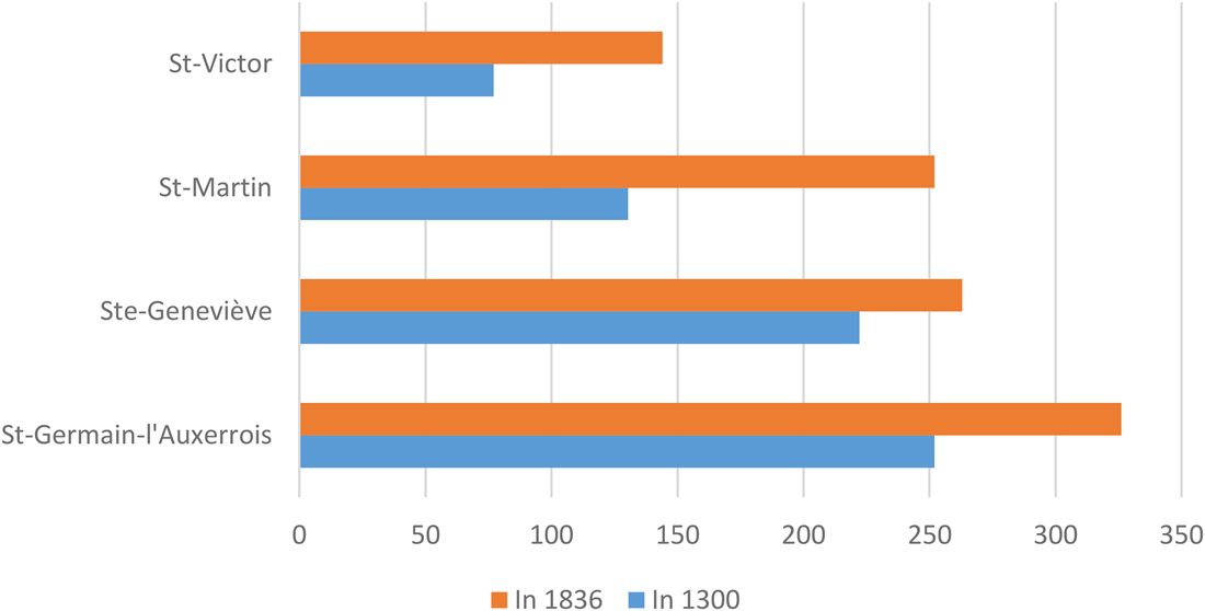
The new indicator proposed corresponds to street density. This can be calculated both in 1300 and in 1836, since the road network is available for both years. In each of the four ecclesiastical quarters for which the GIS automatically provides the surface area, the total length of streets can be calculated. To measure the density of the street system, the total length of the streets is divided by the surface area of each district. The indicator thus obtained for each neighbourhood provides the number of metres of street per hectare. The higher the number, the more densely developed the street system that serves each neighbourhood.
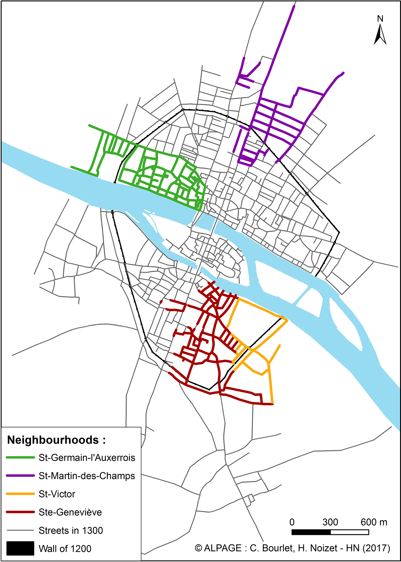
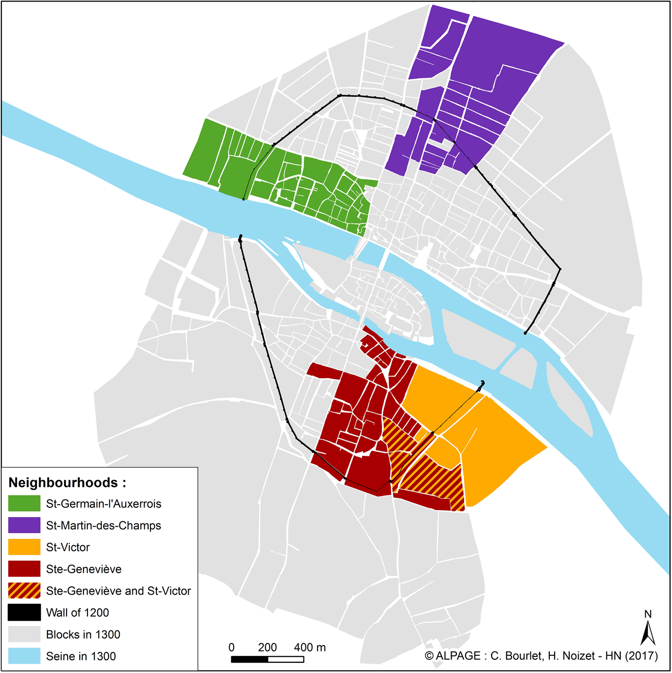
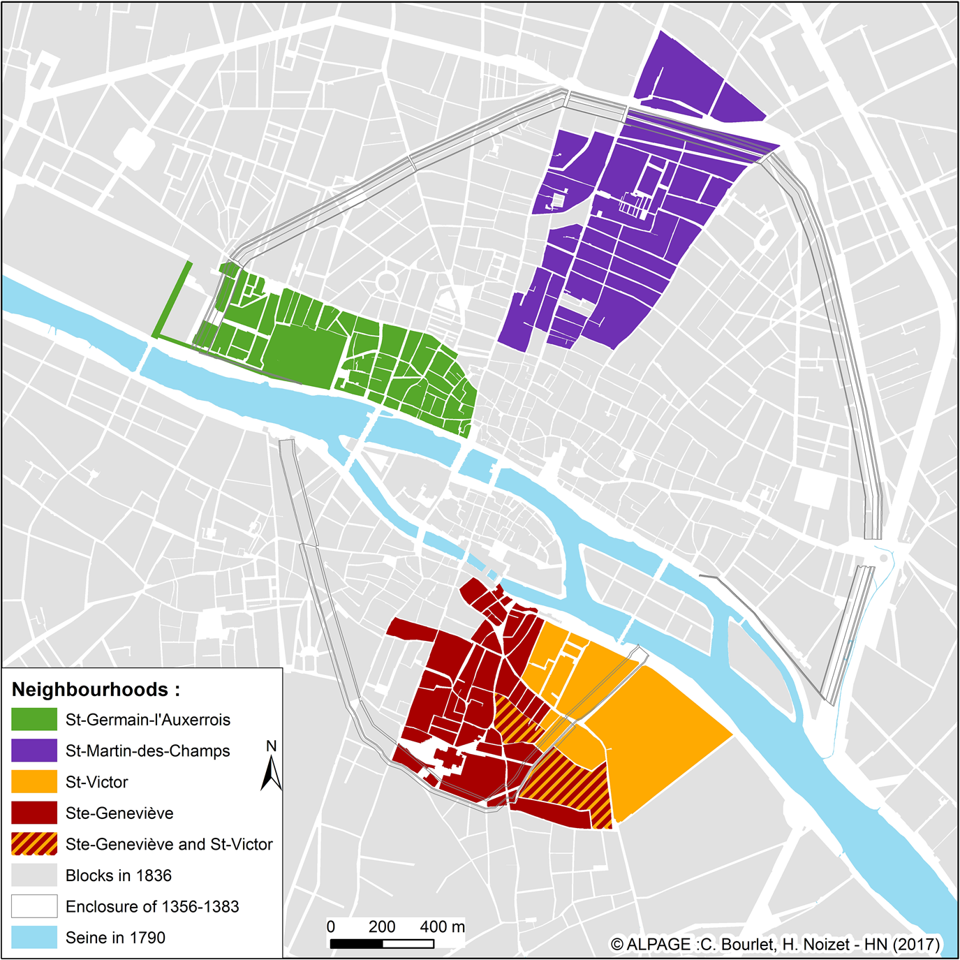
In 1300 as in 1836, the result is revealing because it reflects ecclesiastical status: the more secular the church, the higher the street density in both years (see Figures 1, 2 and 3). St-Germain-l'Auxerrois is characterized by the highest density of streets – 3.3 times higher than in St-Victor in 1300, and 2.3 times greater in 1836. Ste-Geneviève lies in an intermediate situation, while St-Martin is in third position. Between these two dates, the street system expanded at variable rates depending on the area. Logically, the districts least served by streets in 1300, that is to say, the regular districts, enjoyed the most significant increase in density in modern times, from 87 per cent to 93 per cent. Significantly, however, the ranking remains identical at the outset of the nineteenth century despite this highly differentiated evolution. In other words, despite a convergence between 1300 and 1836, the medieval legacies remained significant in 1836. That convergence was particularly marked in the area of St-Martin-des-Champs, which was distinct from Ste-Geneviève toward the end of the Middle Age but was almost on an equal footing with it by the beginning of the nineteenth century.
Street density in 1300 and 1836

Streets in 1300 in the ecclesiastical neighbourhoods of Paris

Streets in 1836 in the ecclesiastical neighbourhoods of Paris

The street blocks
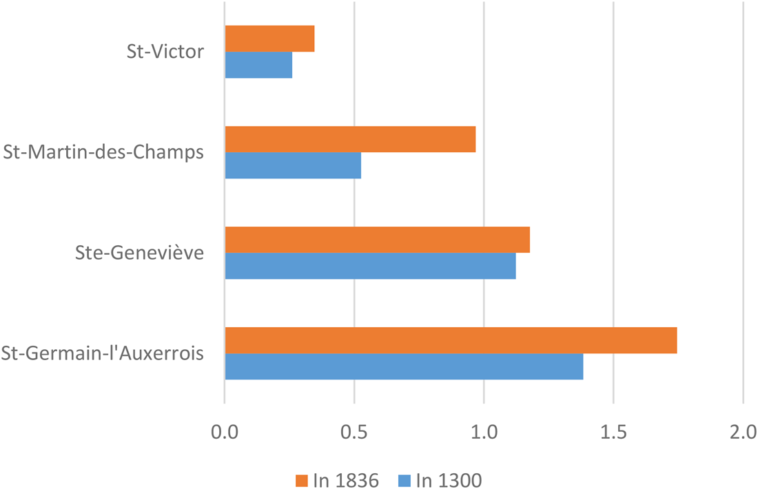
Similar analysis can be carried out on the blocks. Two attributes can be calculated, namely, the density of blocks per hectare (following the same method as for the streets) and the average surface area of the blocks per district. The density of the blocks on average provides the number of blocks per hectare in each neighbourhood. It is inversely correlated with the descriptor of the surface area of the blocks: in a given space, the larger the blocks (i.e. in terms of their surface area) the fewer they are numerically, and hence, the more their density automatically decreases.
As previously, there is an identical ranking: St-Germain-l'Auxerrois in the lead, followed by Ste-Geneviève, then St-Martin-des-Champs, and finally St-Victor. The block density is more than five times higher between the two extreme cases, both in 1300 and in 1836 (see Figures 4, 5 and 6). This factor confirms the correlation between ecclesiastical status and block size: the more secular the status, the denser the block, and the smaller the average parcel area is in both years. Again, the exceptional situation of St-Martin must be noted given its unrivalled rate of growth compared to the blocks in other districts, which signifies that the division of this quarter into residential blocks was far more important in the modern era. This point explains the near equality of Ste-Geneviève and St-Martin in 1836, even though the hierarchical order of the secular establishments in the Middle Ages was reproduced.
Street-block density in 1300 and 1836 (number per hectare)

Blocks in 1300 in the ecclesiastical neighbourhoods of Paris

Blocks in 1836 in the ecclesiastical neighbourhoods of Paris

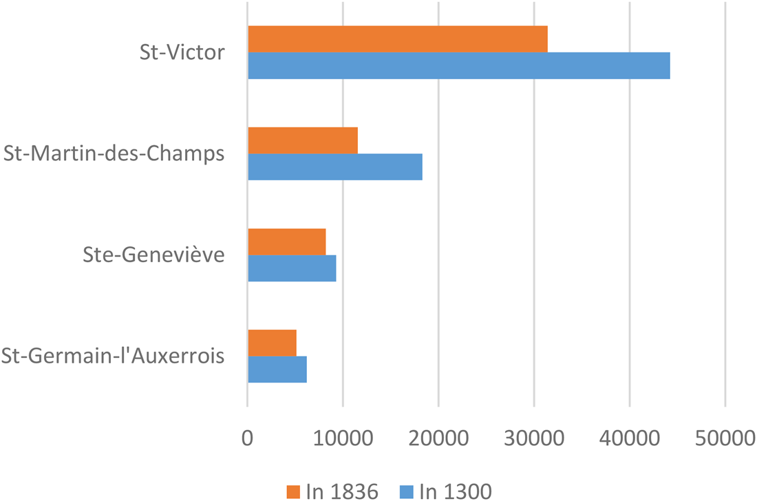
Logically, the most extensive blocks were to be found in regular districts. They were six to seven times larger in St-Victor than in St-Germain-l'Auxerrois both in 1300 and in 1836 (see Figure 3)
Average surface area of blocks in 1300 and 1836 (m2)

Though there is a general tendency towards greater density and reduced surface area of the blocks, it is much more marked in St-Martin-des-Champs. Whether the indicators of density or of surface area are derived from streets or blocks, spatial configuration is consistently more fragmented and denser around secular churches than regular churches. The correlation applies to both 1300 and 1836; the sole difference concerns the St-Martin neighbourhoods that tend over time to approximate to the secular quarters. The morphological differences between secular and regular spaces can therefore be clearly identified as emerging in the Middle Ages and do not simply derive from transformations in the modern era.
Plot density in 1836: density around the secular churches
Since no medieval plot plan for an entire town area is available, either for Paris or elsewhere, a cadastral survey from the beginning of the nineteenth century has been utilized. The absence of medieval cadastral maps is probably not because the documents have disappeared but because medieval societies did not produce them. Textual documents to administer power relations and to enforce authority in situations involving different interest groups – transferring land, taking out a lease, accepting a minor as an apprentice, arbitrating a dispute between neighbours, judging wrongdoers – seldom required recourse to written authority. Such relationships and commitments were often regulated by procedures, by oaths and vows made by the persons concerned and witnessed and agreed publicly and verbally.Footnote 14
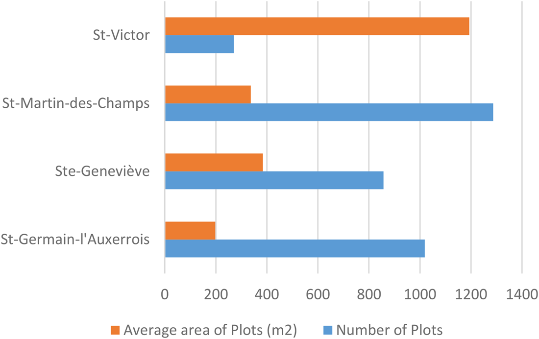
However, the lack of medieval cadastral maps does not entirely preclude analysis. It is possible to postulate some hypotheses by analysing the cadastral map dating from the early nineteenth century, and by comparing other meaningful indicators at two points in time: namely streets and blocks.Footnote 15 Given the interdependence of the various components of an urban space system (streets–plots–buildings), if the pre-industrial cadastral map shared the same features as the pre-industrial streets and fragmented blocks, and if streets and the fragmented blocks already possessed these characteristics during medieval times, then it is probable that the medieval urban space was characterized by the same trends. From the reconstructed maps for 1810 to 1836, we can derive the plots included in each of the four districts, and thus automatically obtain their geometric characteristics, specifically their number and surface area. As with the blocks, a plot density index can be established by dividing the number of plots by the total surface area. This provides the average number of plots per hectare in a particular district. Similarly with the blocks, the plot density indicator is inversely correlated with that of the surface area of the plots. Thus in a given space, the larger the plots, the fewer the number of plots and hence the lower the density (see Figures 8 and 9)
Number and surface area of plots in 1836

Density of plots in 1836 (number per hectare)

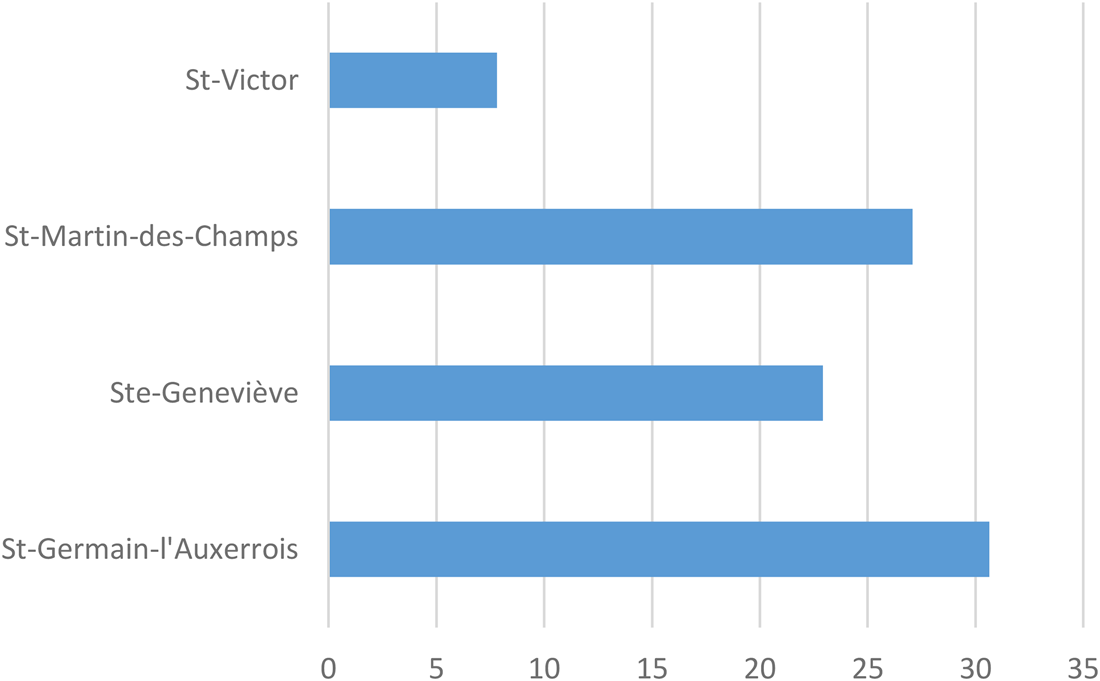
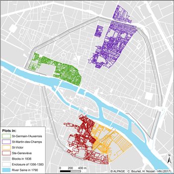
Overall, the analysis of cadastral allotments confirms the model that establishes a correlation between secular and high-density neighbourhoods: the secular (St-Germain-l'Auxerrois) and the regular (St-Victor) establishments are found at either extreme of the spectrum, with a plot density almost four times higher in St-Germain. And, as outlined previously for the blocks from 1300 to 1836, the plot area is, conversely, six times greater in St-Victor than in St-Germain. Once again, Ste-Geneviève occupies an intermediate position. Whether it be the street system, the blocks, or the plots pertaining to these three churches, the urban fabric inherited from the medieval ages is very dense in the secular districts, and, conversely, less dense in the regular districts (see Figure 10).
Plots of 1836 in the ecclesiastical neighbourhoods of Paris

It should be stressed that this progressive structuring of urban space cannot be explained either by a single project or by any deliberate action. No abbot or dean administering these churches deliberately set out to alter the density of their neighbourhood. Ultimately, in carrying out the roles of abbot or dean, these individuals generated these different types of spaces. It may thus be assumed that when an opportunity presented itself for developing the area in the immediate vicinity, secular church interests had a greater tendency to seize it than the regulars.
What spatial practices might explain why the secular interests were more open to densification? The case-study of Tours provides some telling examples of these practices. As they were naturally involved in the practical management of church lands, secular churches took a direct financial interest in the number and nature of tenancies, or authorized the opening of new streets to facilitate exchange, or encouraged the settlement of craftsmen useful for the daily functioning of the church and create facilities to receive pilgrims and patients.Footnote 16 These activities brought them into greater contact with parishioners, and the ensuing density of social relations involved a more frequent subdivision of land. Conversely, monastic communities, and especially nunneries, tended to enclose space, and they were generally more self-contained in terms of governance. Their mission defined their spatial practices.
Sometimes a hybrid form emerged, as in the case of the regular establishment of St-Martin-des-Champs, where a high plot density (27.1 plots per hectare) exceeded that of Ste-Geneviève (22.9 plots per hectare) and was not far off the maximum density achieved by St-Germain-l'Auxerrois (30.1 plots per hectare). Two explanations can be advanced for this deviation from the model. Either the density of plots surrounding St-Martin-des-Champs was already high towards the end of the Middle Ages, in which case the regular status (Clunisian) of St-Martin did not impede the development of land around this ecclesiastical seigneurie. Alternatively, parcelling was at its most intense during the modern period. Were this to be the case, a development occurred after the medieval period that played out at a time when the regular/secular binary no longer operated.
These two different chronological explanations are not mutually exclusive. The monks of St-Martin did not consider the fact of settling dependants in the vicinity as contradictory to their regular status, as can be witnessed by the works already undertaken in this area.Footnote 17 The subdivision into lots of the area located to the south of the monastery was thus realized over the course of the thirteenth century, giving rise to the highly rectilinear division of the four streets between the Wall of Philippe Auguste and the monastic enclosure.Footnote 18 The land fragmentation in this sector was thus operative in the thirteenth century.
This sector constituted only a small part of the whole of St-Martin's landholding, however. It is equally plausible to consider that land fragmentation in the neighbourhood dominated by St-Martin was very pronounced in the modern era. It is as likely that the urban evolution between the end of the Middle Ages and the beginning of the nineteenth century explains the marked land fragmentation of the neighbourhood observable in 1836. Previously, it was noted that the development of streets and blocks between 1300 and 1836 demonstrated the specificity of the St-Martin district, which was characterized by a ‘catch-up’ dynamic higher than in other sectors. Even if the density in all sectors was affected by increasing spatial division, the growth rates of urban structures between the two dates were disproportionate in St-Martin. Thus, it seems that development after the Middle Ages also explains why the pre-industrial plot density in St-Martin is different from what would have been expected given the neighbourhood's status.
Since its settlement dated back at least to the sixth century, St-Martin was located along a major circulatory axis, itself of Roman origins.Footnote 19 There was, thus, an initial impetus that differed from the settlement close to St-Victor. While both these churches were located at a considerable distance from the densely occupied area at the time of their foundation, St-Martin was even farther from the urban centre than was St-Victor. Incidentally, the street St-Martin is mentioned in a charter granted to this church in the year 1070 and it was specifically stated that this street should be kept open for public use, while another street, situated at the foot of the ecclesiastical enclosure, should be put aside for agricultural use in order to feed the monastery's dependants.Footnote 20 This last statement testifies to the fact that at the close of the eleventh century the monastery's immediate surroundings, beyond the major north–south axis, had to remain agricultural and there was no question of settlement in the area. It would be two centuries before the subdivision into lots was undertaken, encouraged by the establishment of the church beside this major road. This spatial heritage dating from the sixth century, reactivated in the mid-eleventh century, undoubtedly affected the practice of subdividing the landholdings in the area into lots in the thirteenth century, thereby providing an example of interaction between form and practice, space and spatiality. The axis of the street St-Martin was thus a pivotal element in the dynamic of fragmentation that developed strongly in this neighbourhood not only throughout the pre-industrial and medieval periods, but also in the modern era. Hence, the model establishing a convergence between secular and high-density neighbourhood is not challenged by the example of St-Martin. Even if the tension between contact and distance with the lay population – meaning with others of any kind (men/women, young/old, rich/poor, inhabitants/strangers, lords/serfs, etc.) – was doubtless less evident in St-Martin than in St-Victor, it is not completely absent.
Strengthening of the morphological legacy: the revival of urban form in St-Victor from the Middle Ages to the twentieth century
The proximity with the laity is likely to explain the greater urban densification around secular churches. This correlation is congruent with their function, their place in medieval society, in short with their beliefs. In the words of Godelier,Footnote 21 we have here the spatial translation of an ideal, in other words, of a set of ideas concretized as a material configuration.
Once set up, these urban landscapes keep their plot style as long as they keep a social meaning – either the meaning they are given at the beginning of the process (which might last several centuries), or new meanings that proved to be newly useful to these urban forms, thus becoming spatial legacies. Both can be observed in the example of St-Victor, where subsequent social configurations re-enacted the urban landscape.
First, in the 1240s, the establishment of the BernardinesFootnote 22 close to St-Victor corresponds to the Cistercian reactivation of the low spatial density of the St-Victor sector. Here, near St-Victor, the Cistercian settlement of the Bernardines reactivated the low plot density and building fabric. This Bernardines’ College forms a vast enclosure located between St-Nicolas-du-Chardonnet and St-Victor, in an urban area that was then relatively diffuse, according to the cadastral maps of 1810 to 1836. This new regular establishment, set up about 130 years after St-Victor, has its own social context, independent of the foundation of St-Victor. However, the pre-existence of St-Victor in this sector could have been an element that came into play when the Cistercian order chose to settle there from the 1240s onwards. Beyond land-based opportunities and the proximity of the university on the left bank of the river, which obviously played a key role, the environment could be considered as conducive to the practice of a Cistercian way of life. Even were it to be proved that there were no direct relationships between the two regular settlements, St-Victor and then the Cistercians, the attraction that the St-Victor neighbourhood had for the Cistercians probably resulted from spatial conditions: the fact that the surrounding neighbourhood furnished sufficient amenities for the requirements of monastic wilderness must have made the area more favourable. Therefore, these regular establishments stayed here for a long time, retaining their social function of providing salvation to souls through prayer and study up to the French Revolution.
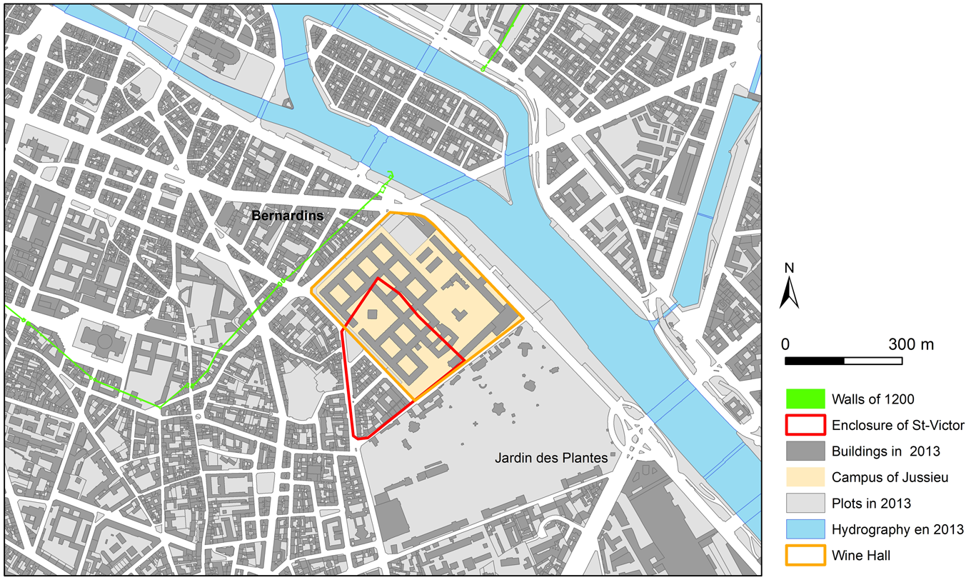
Second, in the nineteenth to twentieth centuries, totally different new establishments caused the low density of this urbanscape to be perpetuated: first the wine market, and then the Jussieu University campus. The wine market, present from 1664 on the site currently occupied by the Arab World Institute, then extended to the former site of St-Victor from 1811. Still in use until 1964, the market was finally replaced by the campus for the Faculties of Science of Paris-7 and Paris-6, constructed between 1958 and 1972. Each time, there was a reuse of the space corresponding to changing social contexts that were disconnected from one another and had different purposes from those of the original religious centre. This development was then followed by a market based on economic interest, concentrated in the hands of the exclusive operators involved in the remarkable expansion of the wine trade in the nineteenth century. Finally, an academic organization anticipated the burgeoning mass of students, reflecting both society's increasing university enrolment and the post-war baby boom. These situations, whilst unique, are not irrevocably singular. They all correspond to configurations that are socially and spatially low density and diversified, characterized by both a dominant mono-activity and actors restricted to a particular type of community (a congregation of canons, a guild of wine merchants and a college of university students and teachers).
These different uses of space around St-Victor all share the need for a very extensive, invariably space-hungry, relationship to the land. This succession of spatial actions through time has produced a specific form, an extensive block, which is currently still undivided into plots (see Figure 11). It reflects the enduring resilience of this morphological legacy in the contemporary building and urban fabric.
From St-Victor to Jussieu: the resilience of a large block in Paris

Conclusion
It was possible for urban morphology to result from social issues, and not only from urban planning. Hence, regular and secular churches can be analysed as social actors that create different kinds of urban spaces. In addition to the intended or planned use of land, and to claims to it, the mode of existence in society generated the form of settlements for centuries. These differing lifestyles – religious lifestyles in this case, though they could have focused on other areas of life – resulted in an urban form that was not planned but developed from a set of values that produced different levels of densification in town. These ways of living, of behaving, in society and of interacting with others have spatial consequences even when they do not have spatial objectives and are accordingly termed spatialities.
Reopening the Paris file merges the results of previous analyses that set out to distinguish a ‘regular spatiality’ from a ‘secular spatiality’ – both characterized by a particular type of relationship with the world, exclusive in nature for the former and inclusive for the latter.Footnote 23 These differing relationships generated many real, if unplanned, spatial effects. The secular spatiality seems heteronomous, meaning highly mediated: it tended to create highly dense, fluid spaces.Footnote 24 By contrast, the regular, autonomous, less-mediated spatiality tended to produce spaces that were neither fragmented nor very dense or fluid.
Thanks to the spatial data, and mainly the use of GIS to analyse plot maps, the effects of these spatialities were observed: they are not only abstract ideas but also have a strong influence on the urban landscape through the development of planned units that are more or less dense and divided. It is possible to measure precisely and automatically the size and density of streets, blocks, plots and buildings for huge areas as soon as these urban forms are vectorized in a GIS. Without geomatic data, urban forms achieved by spatialities are not visible due to their great extension: the urban forms seen without this data often cover hundreds of thousands of blocks, plots or buildings. Hence, GIS makes it possible to create new objects of research that consider the spatial dimension of these societies.
These social urban forms were able to develop in the long term as long as they had social meaning. Hence, they created a morphological legacy through two different processes: either the initial social function of an urban form lasted for a long period, or the same urban form was steadily reappropriated in different ways. The Parisian example of St-Victor demonstrates both modes. On the one hand, the function of this regular church, which justifies its remote position and relative distance from the town centre, lasted from its founding (in 1114) up to the French Revolution. During this long period, secular and regular communities tended to maintain their different relationships to the world and to attract churches that followed the same ideals. On the other hand, when the function of the regular churches was no longer fundamental for the societies of the nineteenth and twentieth centuries, which separated the salvation of souls from world affairs, the space inherited from St-Victor – i.e. a wide block that was not divided into plots – was reused for economic, then educational, purposes (initially as a wine market, later as a university campus). These two successive functions needed large areas, but they were conditioned by different social factors: first, the new strength of the capitalist economy, and then the democratizing of higher education. Spatialities thus play a part in creating spaces, and vice versa, especially when this interdependence is frequently re-enacted over time.
Supplementary material
The supplementary material for this article can be found at https://doi.org/10.1017/S0963926820000231.