INTRODUCTION
The debate over the chronology of the Iron Age is one of the central controversies in the current scholarship of the archaeology of the southern Levant as well as biblical studies. A solid chronology is crucial for researching various topics, such as settlement patterns, demography, economy, administration, correlation of events known from Egyptian and Mesopotamian sources with archaeological data, and the historicity of events mentioned in the biblical tradition. Despite the great efforts invested in the construction of a chronology for the southern Levant, many of the early events in the history of the Kingdom of Judah are still dated by hypothetical historical considerations. A major question is when the kingdom spread from Jerusalem in the hill country to the lower Shephelah region in the southwest (Garfinkel et al. Reference Garfinkel, Ganor, Hasel and Galil2012, Reference Garfinkel, Streit, Ganor and Hasel2015; Sergi Reference Sergi2013; Na’aman Reference Na’aman2013; Lehmann and Niemann Reference Lehmann and Niemann2014). This fertile and densely occupied zone became the backbone of the kingdom (Figure 1).
The Kingdom of Judah and the locations of the various sites mentioned in the text.

Radiocarbon (14C) dating for the Iron Age in the southern Levant was introduced more than a decade ago in order to resolve the disputes. Some progress has been made toward an agreed chronology for the northern kingdom of Israel (Levy and Higham Reference Levy and Higham2005; Sharon et al. Reference Sharon, Gilboa, Jull and Boaretto2007; Mazar Reference Mazar2012), however, it is still not the case for the southern kingdom of Judah. The main problem lies in the quantity and quality of radiometric data from Judah. As a rule, each chronological phase is represented by only one or two samples, and many samples come from unclear contexts in old excavations (Finkelstein and Piasetzky Reference Finkelstein and Piasetzky2010; Asscher et al. Reference Asscher, Lehmann, Rosen, Weiner and Boaretto2015; Boaretto et al. Reference Boaretto, Sharon, Gilboa, Bunimovitz and Lederman2016). Some studies have tried to overcome this problem by modeling the dating of periods with the help of data from the entire southern Levant, lumping together Judah, Israel, and Philistia. These dating models assume that cultural changes occurred in different places at the same time, an assumption that largely overlooks regional variations. Our study, on the contrary, deals with one small region: the Judean lowland.
In 1847 A. H. Layard excavated the palace of Sennacherib at Nineveh and uncovered the famous relief depicting the assault of the Assyrian army on the fortifications of Lachish. Today, 170 years later, the dating of Lachish’s Iron Age fortifications is hotly debated. Five major proposals have been suggested concerning their date:
1. Early 10th century BCE (Tufnell Reference Tufnell1953; Zukerman and Gitin Reference Zukerman, Gitin, Dothan, Garfinkel and Gitin2016:417).
2. Late 10th century BCE (Aharoni Reference Aharoni1975; Yadin Reference Yadin1980).
3. Early or mid-9th century BCE (Mazar and Panitz-Cohen Reference Mazar and Panitz-Cohen2001; Ussishkin Reference Ussishkin2004, Reference Ussishkin2015; Na’aman Reference Na’aman2013; Katz and Faust Reference Katz and Faust2014).
4. Late 9th century BCE, after the destruction of the nearby large Philistine city of (Bunimovitz and Lederman Reference Bunimovitz, Lederman, Finkelstein and Na’aman2011:42–43; Sergi Reference Sergi2013; Lehmann and Niemann Reference Lehmann and Niemann2014).
5. Sometime during the 8th century BCE (Niemann Reference Niemann2011).
Nearly 250 years separate the earliest and the latest proposed dates. In addition, some scholars have assumed that Level V was a small village rather than a fortified city (Ussishkin Reference Ussishkin2004:76–78; Sergi Reference Sergi2013). In order to solve this controversy a new field project conducted by us at Lachish in the years 2013–2017 uncovered a previously unknown city wall, assigned to Level V. The radiometric dating of this wall clarifies the debate.
METHODOLOGY
Taking into account the problems listed in the introduction, our research was designed in accordance with the following eight methodological principles:
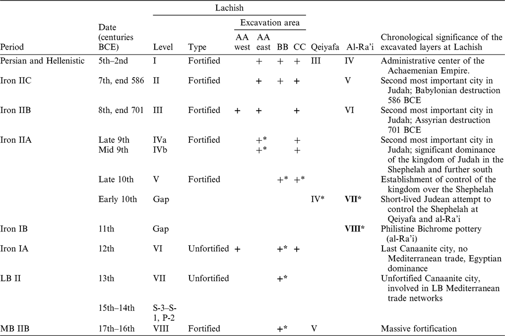
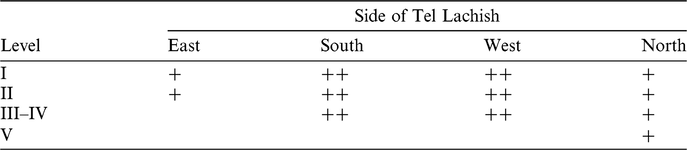
1. Focus on a major site in the kingdom of Judah: We concentrate on Tel Lachish, the second most important city in the kingdom. As the site has been excavated by three earlier expeditions (Tufnell Reference Tufnell1953; Aharoni Reference Aharoni1975; Ussishkin Reference Ussishkin2004) and is mentioned in a number of historical accounts, we already have ample data on its history of occupation, which is summarized in Table 1. What is now beyond dispute in modern scholarship is that Level III was destroyed by the Assyrian King Sennacherib in 701 BCE and Level II was destroyed by the Babylonian King Nebuchadnezzar in 586 BCE.
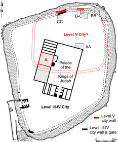
2. Excavation strategy: Three areas were excavated at Lachish. Area AA was chosen in order to obtain a reliable sequence of Bronze and Iron Age levels in the city. Area BB examined the northeast corner of the site. Area BC is located to the west of Area BB. Area CC was chosen in a location where surface surveys indicated a stone-built city wall not reported by previous expeditions; a new city wall, assigned to Level V, was indeed uncovered here and in Area BC.
3. Regional project: Over the last decade we have excavated three Iron Age sites in the Shephelah region: Khirbet Qeiyafa (2007–2013), Tel Lachish (2013–2016), and Khirbet al-Ra’i (2015–2018).
4. Relative chronology: The settlement sequences of the three sites were divided into units according to the stratigraphy and pottery typology. In this way a tight sequence of phases, from the 13th to the end of the 9th centuries BCE, was built up for the research area.
5. Absolute chronology: The various phases were dated by a large number of 14C samples.
6. Samples: Only samples of short-lived organic materials (burnt olive pits or burnt seeds) were chosen for the project and were processed at the Oxford Radiocarbon Accelerator Unit. The dates were calibrated against the IntCal13 calibration curve.
7. Context: Only samples from clear contexts were chosen for dating. We uncovered tens of thousands of olive pits and seeds, but only a few were sent for dating.
8. Sample size: To provide a reliable sample from each level, a few olive pits or seeds were sent from each archaeological context. All the samples were included in the model and none were excluded. In this way we prevented the data from being influenced by preconceptions; no date was considered a priori as too high or too low.
The excavated sequence and the position of the radiometric dates from three sites: Lachish, Khirbet Qeiyafa, and Khirbet al-Ra’i (LB = Late Bronze, MB = Middle Bronze). + phase uncovered by the new expedition (up to 2016 season).

* Samples sent for radiometric dating. Bold entries indicate destruction by fire.
The contexts of the samples that were used to generate the dating were all excavated by us in the last 10 years from three sites all located in the same geographical region, the lowland of the Kingdom of Judah.
Lachish
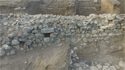
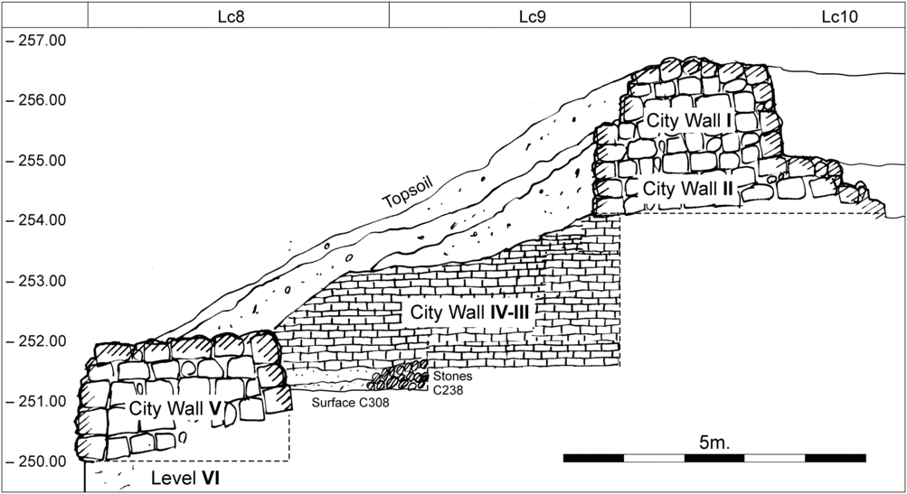
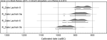
Our expedition to Lachish (2013–2017) was a five-year project aimed at examining Levels V and IV, proposed as an early occupation of the site by the kingdom of Judah by Garfinkel, Hasel, and Klingbeil (Garfinkel et al. Reference Garfinkel, Hasel and Klingbeil2013). The fortifications of Lachish were examined in Areas CC and BC on the northern slope of the site. Additional information derives from Area BB on the eastern side of the site. A major addition to the sequence observed by the previous expeditions was uncovered: a previously unknown city wall. The wall was 3 m wide and built with medium-sized stones. It included a channel that drained water away from the city (Figure 2). The stratigraphy of this new city wall and the floor related to it are important; above the new wall was the city of Levels IV–III, with its 6-m-wide brick-built city wall, and below it was the last Canaanite city of Level VI (Figure 3). The radiometric dating of this wall is based on four olive pits unearthed on Floor C308, that runs up to the wall, and sealed under the mudbrick city wall of Levels IV–III (Figure 4). These dates represent the last years of Level V.
A previously unknown city wall at Tel Lachish (Level V), a 3-m-wide stone construction uncovered in summer 2016. A channel that drained water away from the city can be seen in the center, covered with a large rectangular block of stone (Photo by Emil Aladjem).

Lachish Area CC: cross-section presenting the sequance of the fortifications on the northern slope of the site. The city walls of Levels I, II and V were built from stones. The city wall of Levels IV–III was built from mudbricks. The olive pits sent for radiometric dating came from Floor C308 of Level V. This floor runs up to the stone city wall of Level V, and covered by the mudbrick wall of Levels IV–III.

Lachish Area CC: The radiometric dating of four olive pits unearthed on Floor C308, that runs up to the city wall of Level V, and sealed under the mudbrick city wall of Levels IV–III. Sample Lachish 7 is not included here as it is too old, apparently intrusive olive pit from Level VI, some 200 years older.

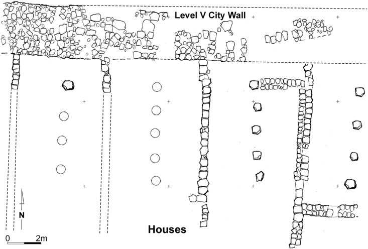
The new city wall was uncovered over a length of 35 m in Area CC and another segment of it was unearthed in Area BC, altogether a length of about 100 m on the northern slope of Lachish. In Area BC typical Judean pillar buildings abut the city wall (Figure 5).
Lachish Area BC: An eastern segment of the Level V city wall, with typical Judean pillar houses abutting it from inside the city. The excavation area was damaged in the north and east by slope erosion.

The new stone-built city wall was not found by any of the three previous expeditions, which excavated in the west and south of the site. This implies that the city of Level V was small and occupied only part of the site, probably 3–4 hectares. Later, in Level IVb, the entire city, covering an area of 7.5 hectares, was encircled by the 6-m-wide mudbrick wall (Figure 6).
Tel Lachish, locations of the various excavation areas and the recently uncovered Level V city wall.

The current expedition also excavated two additional areas at Lachish, as summarized in Table 1. Inside the city, in Area AA (east and west), we uncovered a sequence of levels, including two phases of Level IV. Samples from these two phases were submitted for radiometric dating. In Area BB Canaanite and Iron Age remains were uncovered as well. Samples from Levels V, VI, VII, and VIII were sent for dating. Together, the three excavation areas have covered the history of Lachish from ca. 1800 BCE to 250 BCE. This is, however, an interrupted sequence with various gaps in the site’s history.
The samples were taken from the following levels and contexts:
1. Middle Bronze, Level VIII, Area BB (6 samples, Locus BB466): a large concentration of cereals, probably from burned sacks that collapsed from the second floor during the destruction of a massive mudbrick structure.
2. Late Bronze, Level VII, Area BB (2 samples, Locus BB1145): burnt destruction debris with concentrations of seeds that were sealed under the floor of the Level VI temple.
3. Iron Age IA, Level VI, Area BB: massive destruction of the last Canaanite city of Lachish. One context was a storage jar filled with thousands of burnt seeds that was found in a domestic structure (6 samples, Locus BB144). The second context was a storage jar filled with thousands of burnt seeds that was found in a temple (6 samples, Locus BB244).
4. Iron Age IIA, Level V, Area CC (5 samples, Locus CC308): a floor that runs up to the inner side of the stone-built city wall, sealed under the mudbrick city wall of Levels IV–III. The floor was laid on top of the destruction layer of Level VI. This is the first time that the northern edge of the site had been examined (Table 2).
5. Iron Age IIA, Level V, Area BB (2 samples, Locus BB626): debris, concentration of ash, and burnt olive pits scattered on a floor, sealed by additional debris of Level V and lying directly above the destruction layer of Level VI.
6. Iron Age IIA, Level IVb, Area AA (4 samples, Locus AA236): burnt olive pits scattered on a floor relating to the lower phase of Level IV, about half a meter lower than the next context.
7. Iron Age IIA, Level IVa, Area AA (6 samples, Locus AA239): burnt olive pits scattered on a floor relating to the upper phase of Level IV, found under the Level III destruction by Sennacherib (701 BCE).
The sequence of the late fortifications at Tel Lachish, combined data from all relevant expeditions to the site. + Uncovered by our expedition (east side: Area BB, north side: Area CC). ++ Uncovered by previous expeditions.

Khirbet al-Ra’i
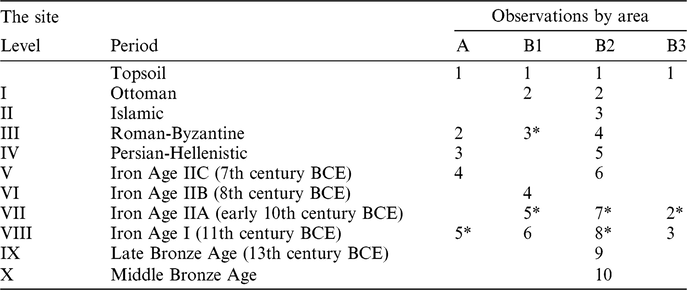
Our expedition to Khirbet al-Ra’i started the field work in 2015, and the project aimed at examining this ca. 1.7 hectare site located 3 km west of Lachish (Garfinkel and Ganor Reference Garfinkel and Ganor2017). The site sits on the border between Judah and Philistia, opposite the Philistine city of Ashkelon. Our expedition opened two main areas (A and B); the occupation sequence of the various areas is summarized in Table 3. In Area A a massive structure dating from the Iron Age IB was unearthed. In Area B a sequence of domestic structures was exposed, ranging from the Iron Age I to the Iron Age IIB.
Khirbet al-Ra’i, summary of the site: stratigraphic observations and pottery assemblages according to the various excavation areas.

* Level with domestic architecture.
Of relevance to our presentation here are Levels VII and VIII. Level VIII has been uncovered mainly in Area A, at the southern edge of the site, where a massive stone structure was partly exposed. It came to an end in a massive destruction, as indicated by the layer of burnt bricks that accumulated above its floors. A concentration of burnt olive pits and pottery was found on a floor outside the building, abutting it from the west (Locus A10). Further remains of this level were found in Area B. Among the notable finds in this level is Philistine Bichrome pottery, typical of the Iron Age IB (11th century BCE). Level VII has been uncovered mainly in Area B on the eastern edge of the site, in three nearby locations (B1, B2, and B3). Well-built architecture was found, built of massive stones and mud bricks. The level came to an end in a massive destruction. The pottery here is typical of the early Iron Age IIA, similar to the pottery uncovered at Khirbet Qeiyafa. Indeed, the radiometric dates from both sites indicate that they were occupied simultaneously.
The samples came from two different contexts, each from a different level:
1. Iron Age IB, Level VIII, Area A: burnt olive pits scattered on a floor that runs up to the outer side of a massive stone structure. The floor included a large quantity of restorable pottery (5 samples, Locus A10). Notably, the level yielded Philistine Bichrome pottery, a ceramic phase not represented at Lachish or Khirbet Qeiyafa.
2. Iron Age IIA, Level VII, Area B: samples collected from the bottom of a single storage jar, found with other jars in a heavy destruction layer characterized by a fierce fire (5 samples, Locus B331).
Khirbet Qeiyafa
The results of our excavations at Khirbet Qeiyafa (2007–2013) and its radiometric datings have already been published in great detail (Garfinkel and Ganor Reference Garfinkel and Ganor2009; Garfinkel et al. Reference Garfinkel, Ganor and Hasel2010, Reference Garfinkel, Ganor, Hasel and Galil2012; Reference Garfinkel, Ganor and Hasel2014, Reference Garfinkel, Kreimerman and Zilberg2016; Keimer et al. Reference Keimer, Kreimerman and Garfinkel2015; Garfinkel Reference Garfinkel, Schroer and Münger2017). The dates from the short-lived Level IV Iron Age IIA city (Garfinkel and Kang Reference Garfinkel and Kang2011; Garfinkel et al. Reference Garfinkel, Ganor, Hasel and Galil2012, Reference Garfinkel, Streit, Ganor and Hasel2015) can be divided into two types of contexts.
1. Burnt olive pits scattered on floors of various structures, accumulated in the city during its existence (11 samples, Loci: B214, B232, B277, B383, B284, C6155, C6160, C6836).
2. Burnt olive pits uncovered inside a single jar originating from the destruction level. These samples represent the last years of the city (4 samples, Locus C6988).
Only the samples of olive pits taken from the jar in Locus C6988 and dated by Oxford University are integrated here into the Bayesian model. This is done in order to eliminate differences between laboratories. In any case, when all the Khirbet Qeiyafa dates are taken into account the final results are the same (Garfinkel et al. Reference Garfinkel, Streit, Ganor and Hasel2015).
RESULTS
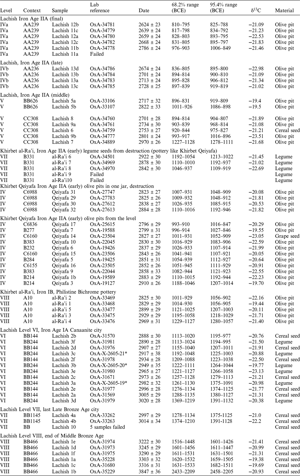
The results of the three sites are presented in Table 4 and Figure 7. Altogether, 67 samples were submitted to the Oxford Radiocarbon Accelerator Unit at the University of Oxford. Eight samples failed during the preparation stage. It turned out that no carbon had been preserved in the submitted material. The successful 59 results include 36 samples from Lachish, 15 samples from Khirbet Qeiyafa, and 8 samples from Khirbet al-Ra’i. All samples have been calibrated against IntCal13 (Bronk Ramsey Reference Bronk Ramsey2009a, Reference Bronk Ramsey2009b; Reimer et al. Reference Reimer, Bard, Bayliss, Beck, Blackwell, Ramsey, Buck, Cheng, Edwards, Friedrich, Grootes, Guilderson, Haflidason, Hajdas, Hatté, Heaton, Hoffmann, Hogg, Hughen, Kaiser, Kromer, Manning, Niu, Reimer, Richards, Scott, Southon, Staff, Turney and Plicht2013).
Radiometric dates from Lachish, Khirbet al-Ra’i, and Khirbet Qeiyafa.

* Yield on chemical treatment <10%.
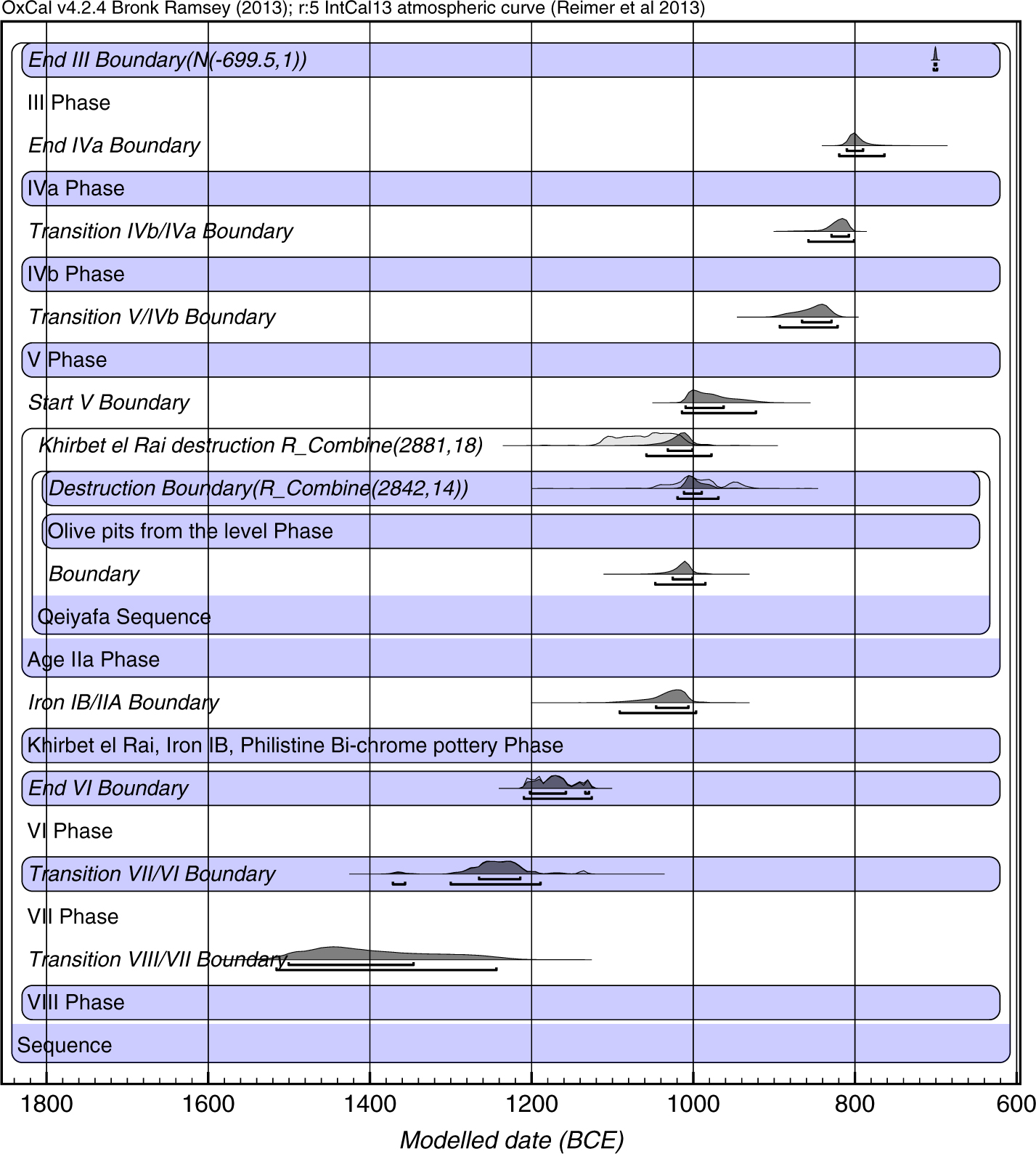
The Bayesian model of the radiometric datings from Lachish, Khirbet al-Ra’i, and Khirbet Qeiyafa.

It is clear that the radiometric dates from Lachish match the stratigraphic positions of the samples; that is, Level VIII dates are the earliest and Level IVa dates are the latest. In the same way, the samples from Khirbet al-Ra’i and Khirbet Qeiyafa fit well into their cultural sequence. There are three outliers from Lachish: a sample from Level VIII from the Middle Bronze Age that is earlier by some 500 years (OxA-35229), which does not affect our model, a sample from Level V that is earlier by some 200 years (OxA-34889, most probably an olive pit intruded into Level V from Level VI), and an olive pit from Level IVa (OxA-34778, most probably residual from Level V). In the same way the radiometric dates from Khirbet al-Ra’i and Khirbet Qeiyafa are consistent with their relative cultural horizons between Lachish Level VI and Lachish Level V. We have here an internally consistent sequence of radiometric dates for what we believe to be the earlier phases of the biblical kingdom of Judah.
The Bayesian model makes use of the phasing within the sites and the relationships between them. There is one problematic date (OxA-35229) which falls within the early Bronze Age period, nearly 500 years earlier than the other samples from the same seed concentration (BB466). This date is clearly an outlier. The destruction events at Khirbet al-Ra’i and Khirbet Qeiyafa are treated as single events and the 14C dates are combined before calibration since they come from single contexts.
At Lachish the boundaries at the end of Level VI and between Levels VI and VII are treated as single events dated by multiple 14C dates. For these boundaries and for all the phases the 14C dates are given a 5% probability of being an outlier (Bronk Ramsey Reference Bronk Ramsey2009b). The end of Level III at Lachish is given a fixed date of 701 BCE.
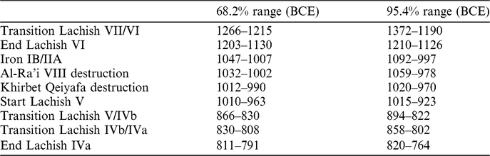
The constraints and relationships defined within the model are shown in Figure 7 along with the probability distributions arising from the model. Table 5 gives the results of the Bayesian analysis for the main transitions relevant to Lachish and informs the main discussion of the chronology in the paper.
Main transition dates from the Bayesian analysis.

The combined dating of the three sites provides the following sequence. Lachish Level VIII, the last Middle Bronze Age city, was destroyed in the mid-16th century BCE, a date corresponding with the end of the so-called Hyksos period, the beginning of New Kingdom Egypt and Egyptian dominance in Canaan (Weinstein Reference Weinstein1981). Lachish Level VII, a Late Bronze Age Canaanite city, was involved in the Mediterranean trade network (Ussishkin Reference Ussishkin2004:59–69), and was destroyed in the last quarter of the 13th century, and not around 1200 BCE. Lachish Level VI of the Iron Age IA, the last Canaanite city, was destroyed at some time in the mid-12th century BCE, as has previously been suggested. The Iron Age IB, represented by Level VIII at Khirbet al-Ra’i, ended at the end of the 11th century BCE. Khirbet Qeiyafa Level IV and Khirbet al-Ra’i Level VII demonstrate that the early Iron Age IIA started as early as the very late 11th or the very beginning of the 10th century BCE. These results accord with the previous results from Khirbet Qeiyafa (Garfinkel and Ganor Reference Garfinkel and Ganor2009; Garfinkel et al. Reference Garfinkel, Ganor, Hasel and Galil2012, Reference Garfinkel, Streit, Ganor and Hasel2015) and contradict Finkelstein and Piasetsky’s analysis (Reference Finkelstein and Piasetzky2010). Our excavations show that Lachish Level V was a fortified city. The model suggests a date for the construction of the city in the 10th century BCE within the 1σ range, but even within the 2σ range the dates are still within the late 10th century BCE. The construction of Lachish Level IVb is dated to around the mid-9th century BCE, and the dates of Level IVa are in the last quarter of the 9th century BCE.
The new data indicate that the fortified Level V at Lachish was built during the 10th century BCE. The biblical tradition of 2 Chronicles 11:9 may reflect historical memories about intensive construction activities at the time of King Rehoboam. The first Iron Age city, however, was small and occupied only part of the site.
The results demonstrate that the fortifications of Level V were built before the destruction of the Philistine city of Gath and Level IV was constructed around the time of the destruction. It was not the fall of Gath that enabled the fortification of Lachish (Bunimovitz and Lederman Reference Bunimovitz, Lederman, Finkelstein and Na’aman2011; Sergi Reference Sergi2013; Lehmann and Niemann Reference Lehmann and Niemann2014), but rather the opposite: Lachish was fortified nearly a century before the destruction of Gath.
The end of Level IV must have occurred no later than the very early 8th century BCE (even within the 2σ range). Furthermore, these dates give Level III some 80 to 100 years of existence before being destroyed by Sennacherib in 701 BCE.
Lachish does not represent the earliest phase in the expansion of the Kingdom of Judah into the Shephelah. There was an earlier attempt, attested at Khirbet Qeiyafa, in the very late 11th century BCE, which lasted for a very short time and came to a sudden end in the destruction. Now Level VII at Khirbet al-Rai presents the same type of pottery assemblage, the same 14C dates, and it also came to its end by a sudden destruction (Garfinkel and Ganor Reference Garfinkel and Ganor2017, Reference Garfinkel, Ganor and Shai2018). As a result, three chronological stages can be suggested for the expansion of the kingdom of Judah by combining the new radiometric dates, archaeological data, and the biblical narrative. The pottery assemblages of the various levels of Lachish and Khirbet Qeiyafa have already been published in great detail (Tufnell Reference Tufnell1953; Ussishkin Reference Ussishkin2004; Kang and Garfinkel Reference Kang, Garfinkel, Garfinkel and Ganor2009, Reference Kang and Garfinkel2018). Consequently, we argue that the new 14C dates imply a new chronology for the first two centuries of the kingdom of Judah.
DISCUSSION
The Early Phases of the Kingdom of Judah
A major issue in the interpretation of the fortified city of Level V at Lachish is its ethnic identification. The same issue has been raised in connection with the fortified city at Khirbet Qeiyafa. Detailed analysis of the various cultural aspects has clearly shown that Khirbet Qeiyafa was a Judean city (Garfinkel et al. Reference Garfinkel, Kreimerman and Zilberg2016). Lachish is identified as a Judean city based on the cultural continuity from Level V to Level IV and then to Level III, without any destruction episode or drastic cultural change. The pillar houses attached to the city wall in Area BC are a feature of typical Judean urban planning (Figure 5), which was not practiced by other political units in the area. Thus, the Judean city of Level III, depicted on the renowned Sennacherib relief (Ussishkin Reference Ussishkin1982), was the outcome of a long urban process that started as early as the late 10th century BCE.
The data unearthed in our regional project point to the following developments. In the very late 11th and early 10th century BCE, under King David, Judah was a small territory in Jerusalem and the hill country, with the western Shephelah region being marked by Khirbet Qeiyafa and Khirbet al-Ra’i. This first stage, however, collapsed after a few decades, as indicated by the destruction of Khirbet Qeiyafa and Khirbet al-Ra’i at around 1020–970 BCE. These particular events are not mentioned in the biblical tradition, but wars with the Philistines in the time of David are frequently cited.
We assume that around 930 BCE a second expansion phase took place under King Rehoboam, in more or less the same territory as in the earlier phase. The fortified city of Level V was built at Lachish to replace Khirbet al-Ra’i, and Socoh and Azekah were built in the Elah Valley to replace Khirbet Qeiyafa (Hasel et al. Reference Hasel, Garfinkel and Weiss2017). The recent published radiometric datings from Tel ‘Eton fit well into this picture (Faust and Sapir Reference Faust and Sapir2018).
During the mid-9th century BCE the kingdom expanded further to the south to include the Beersheba Valley. At this stage Lachish was no longer a small border city but was centrally located in a larger kingdom. It was now rebuilt in Level IVb as a large administrative center covering the entire area of the mound.
This new understanding, based on freshly excavated archaeological data and new radiometric datings, suggests that approaches that place the beginning of the kingdom of Judah at the end of the 9th century BCE are inadequate. Our results are consistent with an earlier kingdom, which was already in existence two centuries earlier, in the early 10th century BCE.
ACKNOWLEDGMENTS
The Fourth Expedition to Lachish was co-sponsored by the Institute of Archaeology, the Hebrew University of Jerusalem, and the Institute of Archaeology, Southern Adventist University, under the co-direction of Yosef Garfinkel, Michael G. Hasel, and Martin G. Klingbeil. Consortium institutions include Seoul Jangsin University (Korea), Oakland University and Virginia Commonwealth University (USA), the Adventist International Institute of Advanced Studies (Philippines), Helderberg College (South Africa), and the Universidad Adventista de Bolivia. The excavation work is undertaken in cooperation with the Israel Antiquities Authority, the National Parks Authority, and the Israel Exploration Society, and is affiliated with the American Schools of Oriental Research. The excavations at Khirbet Qeiyafa and Khirbet al-Ra’i were sponsored by the Institute of Archaeology, the Hebrew University of Jerusalem, under the direction of Yosef Garfinkel and Saar Ganor. Constant support for the latter two projects was supplied by J.B. Silver and the Nathan and Lily Silver Foundation.
SUPPLEMENTARY MATERIAL
To view supplementary material for this article, please visit https://doi.org/10.1017/RDC.2019.5