INTRODUCTION
In the Peruvian Andes, páramo and related types of high altitude Neotropical grassland ecosystems possess high biodiversity and provide important geo-ecosystem functions (Myers et al. Reference Myers, Mittermeier, Mittermeier, da Fonseca and Kent2000). Largely occurring as ‘islands in the sky’, their bio- and geodiversity is seriously threatened by rapidly expanding, changing and intensifying land use, as well as by climate change (Recharte et al. Reference Recharte, Arevalo and Glave2003).
The need for science-based information
Current studies focus mainly on biodiversity and land-use planning as a tool to reduce or mitigate human impacts on ecosystems. Ecosystem functions and services include agriculture (cropping, husbandry and forestry), water supply (drinking water, irrigation water and hydroelectric power) (Buytaert et al. Reference Buytaert, Célleri, De Bièvre, Cisneros, Wyseure, Deckers and Hofstede2006; Harden Reference Harden2006), carbon storage in both soil and vegetation (Tonneijck Reference Tonneijck2009), mining (BRGM [Bureau de Recherches Géologiques et Minières] 2001) and tourism. The geo-archive function, for example documentation of geological type localities and the preservation of peat and lake-fill deposits that may hold important climate proxies, is neglected. The geo-archive function is related to geodiversity and may require an alternative approach in conservation and ecologically sustainable management, in terms of background information required and measures to be taken. The proper evaluation of the hydrological and soil carbon storage functions of different landforms requires objective assessment criteria to assess the scientific relevance and environmental vulnerability of existing geodiversity. A scientific approach to the identification, valuation and documentation of potential geoconservation areas is necessary.
Geodiversity has been defined as ‘the natural range (diversity) of geological (rocks, minerals, fossils), geomorphological (landforms, processes) and soil features. It includes assemblages, relationships, properties, interpretations and systems’ (Gray Reference Gray2004). Concepts related to geoconservation originate mainly from Australia and Europe, where, in nature management and legislation, increasing attention has been paid to the identification of geoconservation sites in relation to planning (Sharples Reference Sharples2002; Gray Reference Gray2004; Burek & Prosser Reference Burek, Prosser, Burek and Prosser2008). Geodiversity assessment results should enhance or broaden existing conservation policies and objectives established in national, regional and local protected areas. In Latin America, however, recognition of the value of geodiversity in itself, in terms of identification and protection of landforms and deposits, is still in its infancy, and the geodiversity functions of páramo areas are therefore often unknown to politicians and the general public. Exceptions are areas of outstanding natural beauty, such as Huascarán National Park, established to protect the Cordillera Blanca in Peru (Sevink Reference Sevink2009) and major fossil bearing sites, such as Puyango Petrified Forest in Southern Ecuador (Shoemaker Reference Shoemaker1977). However, these areas are protected because of their scenic beauty (tourism), economic and/or scientific value (fossils), and important storage and buffering function in the generation of water.
In the Peruvian Andes, there is an abundance of glaciated or recently deglaciated regions, which have as yet only been investigated partially, but are likely sources of scientific information on the Quaternary climate record. Nearly all current information on impacts of natural (Quaternary) and human-induced climate change in the tropics stems from deposits and landforms in the high Andes. Examples include studies of lake sediments and landforms in the high altitude sedimentary basins of Central Colombia (van der Hammen & Hooghiemstra Reference Van der Hammen and Hooghiemstra1997; Torres Torres et al. Reference Torres Torres, Vandenberghe and Hooghiemstra2005) and in the Cordilleras of Peru (Rodbell Reference Rodbell1992; Mark & Seltzer Reference Mark and Seltzer2005). Furthermore, important geoheritage sites are often prehistoric sites, for example caves and rock shelters in specific formations such as the various Bosques de Rocas in Northern and Southern Peru and Chile (Lynch Reference Lynch1986).
Sources for science-based information on geodiversity in Peru are scarce. The national geological maps at reconnaissance scale are strongly biased towards assessment of potential for mineral deposits and thus lack sufficient information and detail on surface deposits. There are few detailed geomorphological and soil maps at a scale relevant for land-use planning at local or regional level (Bussink & Hijmans Reference Bussink and Hijmans2001). To fill this apparent gap, we applied a method for geodiversity assessment developed for the Austrian Alps (Seijmonsbergen et al. Reference Seijmonsbergen, De Jong and de Graaff2010) to the Las Lagunas site (Fig. 1). We aimed to identify and document potential science-based geodiversity information for the Las Lagunas area, by collecting and analysing potential geoconservation data and examining related landscape functions in detail. Such data provide evidence supporting the need to protect the fragile páramo geo-ecosystem, which has been increasingly affected by ongoing land use and climate change.
Location of the study area Las Lagunas in northern Peru. The location of the cross section refers to that shown in Figure 4.

METHODS
Study area
Las Lagunas is a formerly glaciated area lying c. 3500–4600 m above sea level, with varied geology and relatively pristine jalca vegetation (Sanchez et al. Reference Sánchez Vega, Cabanillas Soriano, Miranda Leiva, Poma Rojas, Díaz Navarro, Terrones Hernández and Bazán Zurita2005). Its present climate is classified as ‘Tropical Summer Rain High Mountain’ climate (HAw; Rudloff Reference Rudloff1981). Land use is largely limited to extensive grazing. Nearby is the huge Yanacoccha gold mine, holding mining concessions for parts of the Las Lagunas area.
The geology of the area consists of a folded and faulted basement of Mesozoic sedimentary rocks, partially covered by more recent (Tertiary-Quaternary) effusive volcanic rocks (Molina & Little Reference Molina and Little1981; Ramos Reference Ramos1999; Carrascal-Miranda & Suarez-Ruiz Reference Carrasca-Miranda and Suarez-Ruiz2004; Hermoza et al. Reference Hermoza, Brusset, Baby, Gil, Roddaz, Guerrero and Bolãnos2005). The overlying young ignimbrite formations are composed of successive silica-rich white ash flows, ranging between low-density pumice and loose granitic fragments (Wilson Reference Wilson1985).
The Quaternary landforms and deposits belong to a Late Quaternary fluvioglacial depositional complex. The existing geological map makes no further distinction, though it is clear that the Andes was glaciated repeatedly and that deposits are highly varied in origin (Parsons Reference Parsons1982). A recent palaeoecological study of a sediment core from one of the lakes in the area (Weng et al. Reference Weng, Bush, Curtis, Kolata, Dillehay and Binford2006) provided evidence that Laguna La Compuerta (3950 m above sea level; Fig. 1) was covered with ice c. 32 100–15 000 years before present (BP), as inferred from sedimentation hiatuses in the core. Ice-free conditions prevailed 14 900–13 000 BP and near glacial conditions occurred 12 900–11 000 BP (Younger Dryas). However, Weng et al. (Reference Weng, Bush, Curtis, Kolata, Dillehay and Binford2006) provided little information on the spatial extent and former dynamics of the ice cap.
Few data on regional deglaciation after the last glacial maximum (LGM) exist. Some information exists on the former position of equilibrium line altitudes (ELAs) for the Peruvian Andes (see for example Clapperton Reference Clapperton1972; Wright Reference Wright1983; Porter Reference Porter2001; Mark et al. Reference Mark, Harrison, Spessa, New, Evans and Helmens2005; Smith et al. Reference Smith, Seltzer, Rodbell and Klein2005) and the Cordillera Oriental (Rodbell Reference Rodbell1992; Seltzer Reference Seltzer1993; Farber et al. Reference Farber, Hancock, Finkel and Rodbell2005; Mark et al. Reference Mark, Harrison, Spessa, New, Evans and Helmens2005; Ramage et al. Reference Ramage, Smith, Rodbell and Seltzer2005; Smith et al. Reference Smith, Seltzer, Rodbell and Klein2005; Mark Reference Mark2008). During the LGM, an ELA depression of approximately 860 m is assumed for the Cordillera Blanca and >1000 m for the eastern side of the Cordillera Oriental (Smith et al. Reference Smith, Seltzer, Rodbell and Klein2005). According to Rodbell (Reference Rodbell1992), former LGM snowlines fluctuated between 3600 m and 3900 m above sea level on the western side of the Cordillera Oriental, while Smith et al. (Reference Smith, Seltzer, Rodbell and Klein2005) considered the altitude range to be narrower (3850–3900 m above sea level). Mark (Reference Mark2008) showed that reconstruction of palaeo-snowlines based on moraine positions alone is inaccurate, and that mass balance and glacier area based methods for calculation of ELAs were more reliable. Rodbell et al. (Reference Rodbell, Smith and Mark2009) reviewed existing data on Late Glacial and Holocene glacial recession phases for the Andes, finding that during the Younger Dryas local glaciers advanced in the northern and central Andes, while such advances did not appear to have occurred in southern Andean regions.
The altitude range of the Las Lagunas area largely exceeds the ELA values mentioned above, implying that the Quaternary landforms and soils are of Late Glacial age or younger (see also Weng et al. Reference Weng, Bush, Curtis, Kolata, Dillehay and Binford2006). In our study, we focused on the varied landscape in the southern part of Las Lagunas, which includes a series of well preserved ice marginal features. This deglaciation sequence was analysed and found to be a potential reference area for a Late Glacial deglaciated high Andean landscape, meriting proper geoconservation assessment.
Geodiversity assessment
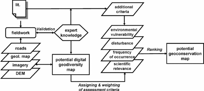
We adapted the geodiversity assessment method originally developed by Seijmonsbergen et al. (Reference Seijmonsbergen, De Jong and de Graaff2010) for the European Alps for application in an Andean setting where less scientific data are available (Fig. 2). Data were collected and stored in a digital geodatabase in ArcGIS 9.3 (see URL at http://www.ESRI.com), based on examples presented by Gustavvson et al. (Reference Gustavvson, Seijmonsbergen and Kolstrup2008). The database included scanned and georeferenced 1:30000 scale panchromatic air photos from 1961, a Landsat satellite image (path/row: p009r065_7k20010824_z17nn) and a 90-m resolution digital elevation model (DEM), downloaded from the Global Land Cover Facility (URL http://glcf.umiacs.umd.edu/index.shtml). A digital geodiversity map was produced through stereoscopic interpretation and analyses and digitization in a geographical information system (GIS). We validated the quality of the potential geodiversity boundaries and preliminary interpretations, and the available geological maps by field survey. We made a detailed study of exposures of unconsolidated materials for their composition, genesis and position in the landscape. We used the collected and processed data to construct a digital geodiversity map that formed the basis for the final potential geoconservation map.
Workflow of geodiversity assessment method for constructing potential geoconservation maps in a high Andean setting.

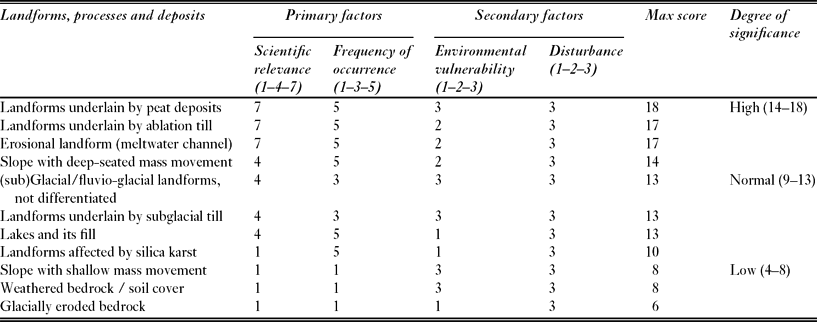
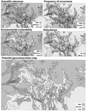
We considered four factors when assessing the final degree of significance in the potential geoconservation map, namely scientific relevance, frequency of occurrence, disturbance and environmental vulnerability (Coratza & Giusti Reference Coratza and Giusti2005; Pralong Reference Pralong2005; Seijmonsbergen et al. Reference Seijmonsbergen, De Jong and de Graaff2010). Scientific relevance refers to a landform's potential to hold information for scientific research. The frequency of occurrence is a measure of the uniqueness of a landform or deposit in the context of the Peruvian Andes. Disturbance refers to the degree to which a landform or deposit has already been disturbed by human activity. Environmental vulnerability or ‘degree of sensitivity to environmental change by external impacts’ (Kværner et al. Reference Kværner, Swensen and Erikstad2006) refers to the effect natural processes and/or human activity will have on a landform or deposit. Each factor used to evaluate the landforms, materials, and processes in Las Lagunas was weighted, scored and ranked (Table 1). GIS largely automates the assignment, combination and ranking of these scores. The ’disturbance’ factor was automatically assessed in GIS by intersecting the available roads infrastructure vector layer with the boundaries of the potential digital geodiversity map. An undisturbed score of ‘3’ could be lowered to a score of ‘2’ if roads intersected with polygons of the potential digital geodiversity map. The resulting potential geoconservation map contained three categories, namely a low, normal or high degree of significance for geoconservation, based on ranking of the maximum scores (see Table 1).
Overview of the weighting and ranking method for landforms, processes and deposits in Las Lagunas. Individual scores are given for the primary factors (scientific relevance and frequency of occurrence) and the secondary factors (environmental vulnerability and disturbance). The range of possible scores has been indicated between brackets below the four criteria. Maximum scores are ranked into three categories (high, normal and low) by degree of significance.

Additional assessment criteria related to the existing status of internal and/or external ecosystem functions of the area, which were examined during the field survey. Internal functions related to activities important for the local area, while external functions related for example to the water storage and supply function for population concentrations in semi-arid lowland areas. This was an optional step, which was based on expert knowledge, literature and other thematic data. Additional criteria may have upgraded individual scores to the maximum score of a potential geoconservation unit or downgraded them to lowest possible individual scores upon loss of ecosystem functions, but we did not consider these necessary in the pristine area of Las Lagunas. Geodiversity was finally ranked in three categories of ‘degree of significance’ and visualized in a final ‘potential geoconservation map’. In our assessment, the 580 recognized lakes and their fills were also evaluated and assigned a high degree of significance because they may potentially contain records of climate and deglaciation history (see Weng et al. Reference Weng, Bush, Curtis, Kolata, Dillehay and Binford2006). For visualization purposes, however, we displayed the lakes in blue. The official recognition of the ‘potential geoconservation site’ as a designated geoconservation site is taken by local authorities and is not included here.
RESULTS
Geodiversity information and climate proxies
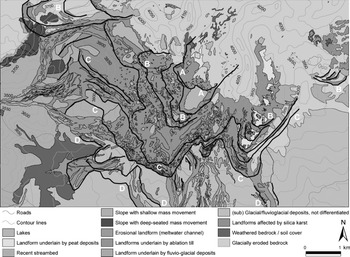
The geomorphological diversity map (Fig. 3) identified areas of potential scientific information. These potential scientific ‘hot spots’ are single landforms or combinations of landforms that could potentially provide information on climate proxies and relevant for understanding and reconstruction of past and present landscape development and ecosystem functioning. A series of well preserved ice-marginal complexes documented stationary phases in the general deglaciation after the LGM. Based on spatial correlation between prominent morainic ridges, four distinct ice-marginal complexes were identified (Fig. 3, A–D) and used to reconstruct and estimate former ELAs (Fig. 4). The ELAs were between 3925 and 4000 m above sea level for the reconstructed glacier levels of the former ice-margins of phases D–A (Fig. 3).
Geomorphological diversity map of Las Lagunas with reconstructed former ice margins (heavy black lines). The four recessional complexes are numbered A (youngest) to D (oldest).

Reconstruction of glacier levels (A-D) of the former ice-cap in Las Lagunas. The location of this cross section is indicated in Figure 1. The glacial deposits are underlain by faulted Mesozoic basement.

The occurrence of subglacial and fluvioglacial deposits beyond the margins of recessional complex D (Fig. 3) suggests that during the LGM the ice cap reached further downslope, in accord with possible lower ELA altitudes between 3600 m and 3900 m (as suggested by Rodbell Reference Rodbell1992). We mapped numerous peat deposits and the locations of possible lake fills that may contain pollen records.
Field observations on exposures in unconsolidated sediments confirmed the general retreat of glacier margins and thus warming of climate conditions after the LGM. Many exposed sediment sequences documented a change from full glacier conditions (subglacial till) to overlying high energy ice-marginal conditions (coarse-grained, non-sorted cobbles, gravel and sand), fine-grained layered fluvial deposits and, finally, soil formation.
The occurrence and size (>150 m wide, >30 m deep and several kilometres long) of former meltwater channels and the distribution of coarse-grained deposits (‘landforms underlain by fluvioglacial deposits’, see Fig. 3) suggest that during retreat from ice-marginal complex D to C sudden releases of meltwater may have occurred, which are tentatively attributed to glacial lake outburst floods (GLOFs).
Geodiversity information and ecosystem functions
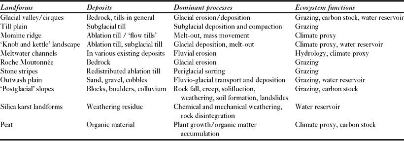
Several ecosystem functions and services preferentially occurred in associations of particular landforms and deposits. Since the landforms and deposits were weighted and ranked, it was also possible to examine the status of the ecosystem function, for example as the result of an external impact such as extraction of water for irrigation. This hydrological function is closely linked to glacial basins and the knob and kettle morphology now consisting of water stagnation areas in which peat bogs developed. Wetlands were particularly present in areas underlain by subglacial till, a reflection of the dense clay and silt-rich low permeability matrix. In contrast, wetlands were scarce in adjacent areas that had not been subjected to intensive glacial deposition (Fig. 3). Here, the presence of undisturbed soil cover still leads to a significant water storage capacity, but in the Mesozoic limestone and Tertiary ignimbrite bedrock infiltration was rapid and deep and often accelerated by prominent karst features. For the area as a whole, the water storage capacity was very high and rainfall peaks were strongly buffered. Five ecosystem functions were linked with the landforms and deposits of Las Lagunas (Table 2).
List of landforms, deposits, dominant processes and associated ecosystem functions in Las Lagunas.

Potential geoconservation map
The potential geoconservation map of the total landscape (Fig. 5) shows areas of low, normal and high potential geoconservation value. In the digital geodatabase the underlying base maps, attributes and additional information, such as maps, imagery and field photos, can be consulted interactively and serve as base-line documents for general and specific information.
Spatial distribution and classes for the four assessment criteria (small maps): scientific relevance, frequency of occurrence, environmental vulnerability and disturbance and their ranked categories. The potential geoconservation map (large map) shows areas with low, normal and high potential for geoconservation value. All underlying weighting and ranking attributes are stored in a digital geodatabase in a GIS.

DISCUSSION
Geodiversity assessment method
The Seijmonsbergen et al. (Reference Seijmonsbergen, De Jong and de Graaff2010) method can be used to identify potential geoconservation sites in the Las Lagunas area and similar former glaciated high Andean locations. It is based on well-developed field protocols and applicable to the total landscape when adequate remote sensing imagery and GIS data are available. The geoconservation map is an important step in developing a more sophisticated landscape approach to geoconservation that can be used to develop an appropriate geoconservation strategy. However, other areas might be less diverse and it is not yet tested whether the methodology is applicable in all situations and at all scales. Some scores depend on interpretation of landform associations. For instance, in the Las Lagunas area all moraine ridges, including those occurring as ‘knob and kettle’ landscapes, have been assigned maximum scores for scientific relevance. Although individually such ’knobs’ have lower value, the association with lakes and peat deposits may potentially hold a detailed climate proxy that documents stepwise deglaciation. Further refinement of the method to increase objectivity is therefore necessary.
Object based image analysis (Drăguţ & Blaschke Reference Drăguţ and Blaschke2006) of high resolution DEMs in combination with the extraction of land surface parameters (Hengl & MacMillan Reference Hengl, MacMillan, Hengl and Reuter2008) has the potential to objectively delineate and classify landforms. In combination with rating scales based on expert knowledge and GIS techniques, such as those presented in this article, these new techniques may lead to objective potential geodiversity maps in the near future. Such high resolution DEMs also promote more detailed analysis and thus improve the quality of the final potential geodiversity map.
Geodiversity information on climate proxies
We selected the Las Lagunas area as a promising case study area (Fig. 3) because of its high potential for hosting climate proxies (as partially explored by Weng et al. Reference Weng, Bush, Curtis, Kolata, Dillehay and Binford2006) which merited further study. We propose, by incorporating the results from Weng et al. (Reference Weng, Bush, Curtis, Kolata, Dillehay and Binford2006) from the core in Laguna La Compuerta (Fig. 1), that the former Lagunas ice cap started melting just after the LGM, and that the ice-marginal complexes B, C and D (Fig. 4) were formed between the LGM and 15 000 BP. All glacial and ice marginal landforms belonging to phase A (see Figs 3 and 4) were of Younger Dryas age (12 900–11 000 BP) or younger. Study of pollen records in peats, to establish the (14C) age of organic material, and the ability to date moraine deposits using optical stimulated luminescence (OSL) techniques would further increase the archive function of Las Lagunas as a reference area for a detailed chronostratigraphy of the Late Quaternary. The well-preserved large meltwater channels in front of recessional complex C (Fig. 3) are consistent with a deglaciation sequence and are thus of great scientific interest. In fact, these channels and the present ‘Lagunas’ may represent relics of former GLOF activity. Recent GLOFs have been reported from the Cordillera Blanca in Peru (Carey Reference Carey2005), but Late Glacial evidence of such activity in the Andes is scarce. The combination of additional sediment records and higher resolution digital evaluation models (Racoviteanu et al. Reference Racoviteanu, Manley, Arnaus and Williams2007) would permit further refinement and completion of climate reconstruction after the LGM. Furthermore, extending the geomorphological mapping from the local to the regional level and beyond might be achieved by upscaling potential geodiversity boundaries, using supervised classification techniques of remote sensing images.
Geodiversity information and ecosystem functions
While we consider the major ecosystem functions for the major landforms, deposits and dominant processes (Table 2), little attention has been given to intrinsic and/or cultural values, aesthetic and economic values. The further integration of such parameters could highlight other potential ecosystem functions and services that are unrelated to underlying landforms and deposits or the four criteria we used in the present assessment. For example, the Yanacocha goldmine (Vargas de Eiden Reference Vargas de Eiden2006) has claimed approximately two-thirds of the present land surface of Las Lagunas, and potentially important peat deposits and the ice marginal landscape may be irreversibly lost as the result of future mining activities. In addition, indirect threats from mining (such as access roads and associated drainage of the area) are likely to reduce the carbon stock potential of the peat bogs and jeopardize the carbon stocks in the thick organic soils that dominate the other landforms.
Most landforms and therefore their ecosystem functions remain intact, as human intervention in the area is as yet relatively low and disturbance is limited. The internal and external function of water in this geo-ecosystem is crucial (irrigation and drinking water), and soil disturbances may directly affect surface and ground water in quantity and quality (Harden Reference Harden2006). The high environmental vulnerability of the wetlands (especially the lakes within the knob and kettle landscape) directly threatens the downstream areas that largely rely for their water on these elevated areas (Buytaert et al. Reference Buytaert, Célleri, De Bièvre, Cisneros, Wyseure, Deckers and Hofstede2006). The peat bogs are also highly vulnerable to degradation induced by groundwater lowering, grazing and reforestation (Wösten et al. Reference Wösten, Ismail and van Wijk1997; Podewojewski et al. Reference Podwojewski, Poulenard, Zambrana and Hofstede2002; Buytaert et al. Reference Buytaert, Iñiguez and De Bièvre2007). Overextraction of water for irrigation purposes may dry out local peat bogs and affect adjacent soil covered slopes, reducing the carbon storage capacity of soils and peat bogs, and thus damaging geo-archives.
After the potential geoconservation classification, a next step is the implementation of the collected information in legislation by local, regional and national authorities, to define protected geoconservation sites and incorporate this information into environmental impact assessments for planning.
CONCLUSIONS
Through this geodiversity assessment, the Las Lagunas area could be recognized as an archive holding a variety of complementary and undisturbed climate proxies, marked by glacial, ice-marginal and postglacial landforms and deposits, pollen records and lake sequences from the LGM into Younger Dryas and the Holocene.
Most geo-ecosystem functions and services, such as grazing, water storage, buffering and irrigation, carbon storage in soil and vegetation, occur in close relation with the underlying landforms, materials and dominant processes (Table 2).
The potential geoconservation map (Fig. 5) constitutes an important basis for future monitoring of geodiversity and therefore the status of these geo-ecosystem functions. We conclude that upon increasing human pressure (for example mining activities, livestock grazing and extraction of water for irrigation and drinking) the carbon storage capacity of the soil and vegetation may be irreversibly degraded.
We hope that this assessment and valuation of the geodiversity of a high Andean area raises awareness among scientists, planners and policy makers of the relevance of geodiversity as an intrinsic property of the landscape and a carrier of several important functions. We encourage the wider application of this method to similar high Andean and other mountain environments. The collected data may eventually be used to assess changes in geo-ecosystem functions and services as a result of human disturbance and climate change.
ACKNOWLEDGEMENTS
This study was carried out under the auspices of the Proyecto Páramo Andino (PPA) by the Institute for Biodiversity and Ecosystem Dynamics (IBED), jointly with The Mountain Institute. We thank Fresia Chunga (PPA) for coordinating the project. Two anonymous reviewers helped to improve the manuscript. We thank the GIS-studio of the University of Amsterdam (URL http://www.GIS-studio.nl) for use of GIS and remote sensing facilities.