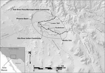
The Akimel O'Odham communities along the middle Gila and lower Salt Rivers in the Phoenix Basin are exceptional for many reasons (Figure 1). For example, the United States Congress established a reservation for the Akimel O'Odhams in 1859, and they were the first native society in Arizona so recognized (Wilson Reference Wilson2014). The Gila River Indian Community (GRIC) is also one of the oldest extant reservations in the country. Furthermore, in contrast to many indigenous communities, the Akimel O'Odhams have successfully expanded their reservation on more than 10 occasions, and a second community was also established along the lower Salt River. Also in contrast to other Native Americans, the Akimel O'Odhams still occupy the same settlement area where Europeans first encountered them (Wilson Reference Wilson2014). As another example, nearly all reservations in the United States are in peripheral locations that are far removed from major centers for Euroamerican settlement, while the Akimel O'Odham communities are located within one of the country's largest metropolitan areas.
Map showing the location of the Gila River Indian Community and Salt River Pima-Maricopa Indian Community.

Prior to the diversion by upstream settlers of the Gila River in the late 1800s, the Akimel O'Odhams were economically prosperous, and they were able to supply large amounts of food to the U.S. military and others (Dejong Reference DeJong2009; Wilson Reference Wilson2014). Irrigation agriculture has long been a focal point for the Akimel O'Odhams, and they are currently in the process of constructing the Pima-Maricopa Irrigation Project (P-MIP), a large-scale agricultural improvement undertaking that extends across nearly the entire GRIC (Ravesloot et al. Reference Ravesloot, Darling, Waters, Fisher, Hill and Feinman2009). In order to document, investigate, preserve, and protect cultural resources, the community created a Cultural Resource Management Program (CRMP) as part of P-MIP. Prior to GRIC-CRMP investigations, comparatively little was known about the reservation's archaeology (Wells Reference Wells2006).
However, at the outset of large-scale archaeological excavations in the Phoenix Basin during the 1930s, researchers recognized that the material cultural traits of Historic period Akimel O'Odhams are highly similar to those of the Preclassic (roughly A.D. 650–1150) inhabitants of the region (Haury Reference Haury1976; Sayles Reference Sayles1938:79–80). This is why these early archaeologists argued that the changes in material culture that occurred during the Classic period (ca. A.D. 1150–1450) were the result of the Salados, who were thought to have moved to the Phoenix Basin and lived alongside the Hohokams. Instead, nearly all researchers now recognize that cultural continuity exists between the Preclassic and Classic periods, and they no longer use “Salado” to refer to the Classic-period inhabitants of the Phoenix Basin. Despite this recognition of continuity between the Preclassic and Classic periods, archaeologists still have questions regarding the relationship between prehistoric and historic Phoenix Basin indigenous populations (McClelland Reference McClelland2015).
In general, archaeologists who have studied prehistoric remains in the Phoenix Basin have ignored Akimel O'Odham cultural traditions (Hill et al. Reference Hill, Lyons, Clark and Doelle2015:618). Even those who have incorporated Native American perspectives have generally combined Akimel O'Odham information with the traditions of people who live outside the Phoenix Basin, especially the Tohono O'Odhams (i.e., Papagos) who live in less well-watered regions to the south (e.g., Rice Reference Rice2016). This mixing of the traditions of people who live in the Phoenix Basin with those of people who live outside the basin has introduced additional variation, and this paper instead focuses exclusively on beliefs of the people who actually live in the area.
The Akimel O'Odham worldview involves an inception, overpopulation and breakdown of traditional practices, and then subsequent destruction; the cycle then repeats (Bahr Reference Bahr1975:77). Unlike the common Western belief of a single instance of creation, the Akimel O'Odham story instead says that the O'Odhams were created and destroyed multiple times, and the population therefore fluctuated dramatically over time. This indigenous paradigm has important implications for the interpretation of material culture variation within the Phoenix Basin (McNiven Reference McNiven2016).
The Akimel O'Odham conception is similar to Puebloan beliefs that describe a cycle of creation and destruction, but there are substantial differences. One fundamental distinction is that the Akimel O'Odham story emphasizes continuity of place, while Pueblo traditions privilege migration. The Hopis, for example, believe this cycle involves movement between “worlds” with people physically leaving one and traveling to the next. In each cycle, the creator becomes unhappy with the transgressions of some people, and so he creates a new world for the few righteous beings (Waters Reference Waters1963). The Akimel O'Odham story emphasizes continuity of place, while Pueblo traditions privilege migration.
Despite many decades of work, little consensus exists regarding what caused the Hohokam Collapse, and researchers still don't agree about the nature of the relationship between prehistoric and historic populations in the area (Ezell Reference Ezell1963, Reference Ezell and Ortiz1983:149–150; Gilpin and Phillips Reference Gilpin and Phillips1998:28–43; Haury Reference Haury1976; Hegmon et al. Reference Hegmon, Howard, O'Hara, Peeples, Der and Fernandini2016; Hill et al. Reference Hill, Lyons, Clark and Doelle2015; Loendorf Reference Loendorf2012; Loendorf et al. Reference Loendorf, Fertelmes and Lewis2013; McClelland Reference McClelland2015; Mills et al. Reference Mills, Clark, Peeples, Haas, Roberts, Hill, Huntley, Borck, Breiger, Clauset and Shackley2013; Nelson et al. Reference Nelson, Kintigh, Abbott and Anderies2010; Ravesloot et al. Reference Ravesloot, Darling, Waters, Fisher, Hill and Feinman2009; Rea Reference Rea2007; Redman Reference Redman1999; Rice Reference Rice2016; Seymour Reference Seymour2011; Tainter Reference Tainter1988; Wells Reference Wells2006). We propose that understanding the changes at the end of the Classic period has been an intractable issue because researchers have tacitly assumed that major changes in material culture patterns indicate that a different ethnic group migrated to the region. Akimel O'Odham cultural traditions suggest that this supposition is incorrect, and we show here that substantial archaeological data support their understanding of the past.
The Akimel O'Odham Creation Story
Rather than a narrative that has historical validity, researchers have generally regarded the Akimel O'Odham creation story as an invention or myth made up to explain the existence of the world (Russell Reference Russell1908:206). Examination of this story, however, shows it has close parallels with the archaeological record (Lewis and Rice Reference Lewis, Rice, Rice and Czarzasty2009; Loendorf Reference Loendorf2012; Rice Reference Rice2016; Teague Reference Teague1993). While there are many written versions of the Akimel O'Odham story, they all share the same basic structural elements (Bahr Reference Bahr1975, Reference Bahr2001, Reference Bahr, Fish and Fish2007; Bahr et al. Reference Bahr, Smith, Allison and Hayden1994; Baker Reference Baker1973; Farish Reference Farish1916; Fewkes Reference Fewkes1912; Grossman Reference Grossman1873; Lloyd Reference Lloyd1911; Robinson Reference Robinson1935; Russell Reference Russell1908; Shaw Reference Shaw1995; Thomas Reference Thomas1917; Webb Reference Webb1959:90–126). Because the story is sacred and strict rules proscribe when it can be told, in the following discussion we summarize a secular version (Russell Reference Russell1908:206–230) that reflects this arcane knowledge as it was taught to the second author. In fact, until recently, Lewis intentionally avoided reading written versions in order to not confuse the information he was taught through traditional Akimel O'Odham practices.
The story begins with Earth Doctor creating the O'Odhams and their world, but the people rapidly became too numerous, so Earth Doctor destroyed his creation. He then made new O'Odhams, but, in contrast to the previous cycle, other supernatural beings, including Elder Brother and Coyote, were also created. “The people increased in numbers, but Elder Brother shortened their lives, and they did not overrun the earth as they had done before” (Russell Reference Russell1908:209). This, however, did not satisfy Elder Brother, and he decided to destroy the people Earth Doctor made. This was accomplished by sending a handsome man who caused increasingly rapid reproduction to occur until he directly gave birth himself, and the tears from that baby caused an overwhelming flood. Before the flood, Earth Doctor helped some O'Odhams escape through a hole in the earth, and he directed others to a high place above the floodwaters.
After traveling back from the distant locations where the water carried them, Coyote, Earth Doctor, and Elder Brother reunited. They agreed that Elder Brother was first to emerge, and he was therefore “the ruler of the world” (Russell Reference Russell1908:213). They traveled again until they found the center of their world, and the three of them made new people and animals. Coyote created web-footed animals, snakes, and birds that Elder Brother said to throw into the water. Earth Doctor made creatures resembling human beings, but they were deformed. Elder Brother told Earth Doctor to put his creations in the west, after which Earth Doctor sank into the ground, leaving sickness behind him. Elder Brother then made new O'Odhams and three other groups of people.
After a series of more detailed events, the O'Odhams decided to kill Elder Brother because he had become mischievous. After three attempts (he revived each time) they enlisted the help of Vulture for a fourth try, but Elder Brother still was not destroyed. In retaliation, he sank into the ground and resurrected the people whom Earth Doctor had previously helped escape (i.e., O'Odhams from before the flood), who proceeded to attack and defeat one by one the platform mound leaders along the Salt and Gila Rivers. Each mound is associated with a specific named individual, such as Morning-Blue for Casa Grande, and Elder Brother himself is connected with a particular platform mound. During the conquest, the mound leaders tried to defend themselves by causing windstorms and other, mostly weather-related, phenomena. After completing the destruction, the O'Odhams from before the flood continued moving with Elder Brother and then eventually returned to the middle Gila River.
The next section summarizes archaeological and paleoclimatic research that suggests why people may have moved among different locations. Factors that could have influenced the population fluctuations that are described in the Akimel O'Odham story are also considered.
Phoenix Basin Environmental Conditions and Constraints
Some anthropologists reject the kind of arguments presented in the following discussion as “environmental determinism” (Dean and Doyel Reference Dean, Doyel, Doyel and Dean2006:1). This is in part because human beings can (and are likely to) respond to the same natural events in different ways (Ingram Reference Ingram2010). For example, some people might react to a catastrophic flood by moving, others could change their social organization to facilitate the increased labor necessary to maintain previous agricultural practices (Waters and Ravesloot Reference Waters and Ravesloot2001:292; Woodson Reference Woodson, Ingram and Hunt2015), and many might simply die. We argue that all of these responses (and others) occurred, and we agree that environmental conditions do not determine cultural practices. Environmental factors, however, constrain human behavior, and it is the responses of individuals to those changing limits that we can see in the archaeological record.
The Phoenix Basin lies at the junction of the Salt and Gila Rivers (see Figure 1). These rivers have substantial differences in the topography and elevation of their drainage basins that affect how climatic variation alters river flows, and consequently they differ substantially in discharge volume (Graybill et al. Reference Graybill, Gregory, Funkhouser, Nials, Doyel and Dean2006:82; Huckleberry Reference Huckleberry, Ingram and Hunt2015:105–106). Annual discharge of the Salt River is determined largely by winter precipitation in the upper reaches of the watershed, while Gila River discharge is much more dependent on precipitation associated with the North American Monsoon (NAM; Graybill et al. Reference Graybill, Gregory, Funkhouser, Nials, Doyel and Dean2006:83–85). Based on differences in reconstructed stream flow patterns between the rivers, Graybill et al. (Reference Graybill, Gregory, Funkhouser, Nials, Doyel and Dean2006:107) argued there were “substantial long-term differences in the timing and magnitude of labor requirements and in the reliability of foodstuffs derived from irrigation farming” along these two rivers.
The stream-flow data are based on dendroclimatology records that are largely derived from trees growing in the upper portions of the watersheds, and consequently these reconstructions do not accurately reflect the contribution of flows from NAM rainfall (Graybill et al. Reference Graybill, Gregory, Funkhouser, Nials, Doyel and Dean2006; Huckleberry Reference Huckleberry, Ingram and Hunt2015:114). Another weakness of the stream-flow data is that it is not possible to determine the configuration and discharge capacities of the river channels (Ravesloot et al. Reference Ravesloot, Darling, Waters, Fisher, Hill and Feinman2009:239). However, geoarchaeological investigations have reconstructed the alluvial histories of the lower Salt and middle Gila Rivers (Ravesloot and Waters Reference Ravesloot and Waters2004; Waters and Ravesloot Reference Waters and Ravesloot2000, Reference Waters and Ravesloot2001). These investigations provide critical data for understanding the development and organization of irrigation communities that were dependent on the two rivers. The studies demonstrate that, after 750 years of floodplain stability and a predictable stream-flow regime, a down-cutting event occurred sometime between A.D. 1020 and 1160, which caused a major environmental catastrophe (Ravesloot et al. Reference Ravesloot, Darling, Waters, Fisher, Hill and Feinman2009:238).
LeBlanc (Reference LeBlanc1999:32–36, Reference LeBlanc2003:147–149, Reference LeBlanc, Arkush and Allen2006) argued that, over the last 2,000 years, a worldwide climatic cycle between warmer and colder conditions affected southwestern agricultural populations. Although the exact timing and local effects of these oscillations remain uncertain, LeBlanc (Reference LeBlanc1999:33) suggested that “any change in temperature could have had major effects on Southwestern crop yields, not only in higher elevations but also in lower ones.” Dean (Reference Dean, McIntosh, Tainter and McIntosh2000:97–101) synthesized paleoclimatic data that show low-frequency and high-frequency climatic change over the last 2,000 years on the Colorado plateau in Arizona and identified intervals of potential environmental stress. He argued that the period between A.D. 900–1130 was the most favorable interval for irrigation agriculture in the last 2,000 years (Dean Reference Dean, McIntosh, Tainter and McIntosh2000:101; see also Huckleberry Reference Huckleberry, Ingram and Hunt2015:106–108). This long interval of stability coincides with the late Preclassic period (A.D. 950–1150). These extended favorable conditions are likely to have resulted in population increases, which would have made groups more susceptible to subsequent climatic events. Following Dean (Reference Dean, McIntosh, Tainter and McIntosh2000), Lekson (Reference Lekson2002) examined dendroclimatology records for the Southwest and identified patterns of “high temporal variability” in resource availability that he associated with cycles of conflict and variation in settlement patterns.
Most recently, Huckleberry (Reference Huckleberry, Ingram and Hunt2015) synthesized Holocene climate data and found that uncertainty exists regarding postglacial climatic variation in the North American Southwest. He concluded that climatic and geomorphological variation are such that it is necessary to study different reaches of rivers on an individual basis (Huckleberry Reference Huckleberry, Ingram and Hunt2015:108). He found that during the Holocene the NAM has provided a substantial proportion of the annual precipitation in the Southwest, and this rainfall is highest in the southern and eastern Southwest (Huckleberry Reference Huckleberry, Ingram and Hunt2015:96). Huckleberry (Reference Huckleberry, Ingram and Hunt2015:106) also observed that the late Preclassic to Classic transition coincides with steady average discharge on the Salt River and high flow variability for the Gila River. While the overall effects of past climatic events remain uncertain, it is clear that southwestern farmers “had to deal with decadal to century changes in temperature and precipitation linked to volcanic eruptions, variable solar output, and ocean-atmospheric dynamics” (Huckleberry Reference Huckleberry, Ingram and Hunt2015:113).
If the climatic variation observed by Huckleberry (Reference Huckleberry, Ingram and Hunt2015), LeBlanc (Reference LeBlanc1999), and others differentially affected summer and winter precipitation patterns in southern Arizona, then, given the variation in the hydrology of the two streams, climatic events that impacted the lower Salt River would not necessarily affect the middle Gila River, and vice versa. This possibility appears to have affected the cultural practices of the irrigation agriculturalists who lived along these streams. The following sections summarize extensive archaeological and historical evidence, which indicates that the highest population density oscillated between the middle Gila and the lower Salt Rivers within the Phoenix Basin.
Prehistoric- and Historic-Period Population Estimation Methods
Southwestern archaeologists have widely employed room counts to approximate prehistoric and historic population sizes (Hill et al. Reference Hill, Clark, Doelle and Lyons2004, Reference Hill, Lyons, Clark and Doelle2015). However, Preclassic- and Historic-period pithouses in the Phoenix Basin are not readily visible on the modern ground surface and can only be identified through excavation, which makes it difficult to count all rooms (Fish and Fish Reference Fish, Fish, Wills and Leonard1994:119). Furthermore, less compact settlement layouts prevailed during both the Preclassic and Historic periods, and the dispersed nature of these villages greatly complicates the identification of every individual room because excavations are generally restricted to small portions of sites (Fish and Fish Reference Fish, Fish, Wills and Leonard1994:119). In contrast, other architectural types, such as masonry houses, are readily visible on the surface. As a result, using room counts to calculate population size will result in the underestimation of people, such as the Preclassic- and Historic-period residents of the Phoenix Basin, who lived in less archaeologically visible architectural types.
Furthermore, there are substantial differences in household organization between northern and southern Arizona that affect the number of rooms constructed per household. In the hotter regions of southern Arizona, many more activities were conducted outdoors, or in ephemeral constructions such as brush kitchens and ramadas that are identifiable only in unusual circumstances (Rice et al. Reference Rice, Upham and Nicholas1983; Russell Reference Russell1908). Consequently, people in southern Arizona built fewer substantial structures per household than did residents of Arizona's colder regions (Cameron Reference Cameron1999:52; Eiselt Reference Eiselt2002; Stone Reference Stone2016:62). Because of these differences in the archaeological visibility of structures and household organization in different regions of the Southwest, any analysis that employs uniform room count assumptions for estimating population sizes will substantially underestimate the Preclassic- and Historic-period occupations in the Phoenix Basin. Therefore, the following discussion also incorporates several other proxy measures (e.g., public architecture size and irrigation system reconstructions) to estimate population densities over time (Fish and Fish Reference Fish, Fish, Wills and Leonard1994; Woodson Reference Woodson2016).
Preclassic- and Classic-Period Settlement Patterns and Material Culture
The down-cutting event identified by Waters and Ravesloot (Reference Waters and Ravesloot2001) that occurred between A.D. 1020 and 1160 coincides roughly with the Preclassic- to Classic-period transition. If the flood described in the Akimel O'Odham story is assumed to correspond with the river channel down-cutting identified by archaeologists, then events immediately prior to the flood occurred in the Preclassic period, while the time immediately after the flood can be inferred to be the Classic period. This down-cutting event happened close to a major climate shift (Dean Reference Dean, McIntosh, Tainter and McIntosh2000:102; LeBlanc Reference LeBlanc1999:35, Reference LeBlanc2003:147–149; Lekson Reference Lekson2002). In the Phoenix Basin, this shift coincided with various changes: pithouses were gradually replaced by surface structures, red-on-buff ceramics became less common, Salado polychromes appeared in the late A.D. 1200s, ball courts were no longer built, platform mounds became the predominate form of public architecture, the incidence of cremation decreased while inhumation increased, and production stopped of some items (e.g., palettes and censers) that appear to be associated with religious activities (Fish and Fish Reference Fish, Fish, Ingram and Hunt2015; Haury Reference Haury1976:286–289; Hegmon et al. Reference Hegmon, Howard, O'Hara, Peeples, Der and Fernandini2016; McClelland Reference McClelland2015; Nelson et al. Reference Nelson, Kintigh, Abbott and Anderies2010; Rice Reference Rice2016).
The down-cutting event made irrigation more difficult (Craig Reference Craig2004:280; Waters and Ravesloot Reference Waters and Ravesloot2001; Woodson Reference Woodson2016), which, when combined with a shift in regional precipitation patterns, may have made some people respond by moving to locations along the Salt River and other areas. Waters and Ravesloot (Reference Waters and Ravesloot2001) argued that aggregation occurred in response to the down-cutting event because of the increased labor necessary for irrigation (Ravesloot et al. Reference Ravesloot, Darling, Waters, Fisher, Hill and Feinman2009). Similarly, in his study of Canal System 2 along the lower Salt, Ingram (Reference Ingram2008:137) found that “population growth rates generally increased as the frequency, magnitude, and duration of inferred flooding, drought, and variability increased.” Ingram (Reference Ingram2010:65) concluded that during the Classic period “this relationship suggests that the lower Salt may have been a refuge for people moving away from other areas.”
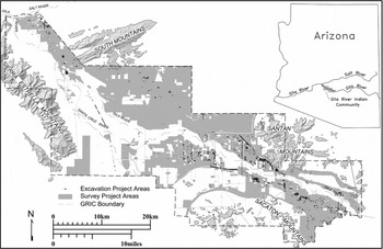
Wilcox and Sternberg (Reference Wilcox and Sternberg1983:198–203) suggested that Snaketown (see Figure 1) was the paramount regional center within the Phoenix Basin during the Preclassic, and Haury (Reference Haury1976) argued that the site was abandoned at the end of the period (Woodson Reference Woodson2016:137). Furthermore, ongoing GRIC-CRMP investigations, which include more than 61,693 hectares (152,446 acres) of full coverage survey, as well as 579 hectares (1,430 acres) where testing and/or data recovery excavations have been conducted provide substantial additional evidence for population loss along the middle Gila during the early Classic period (Figure 2; Darling Reference Darling, Cabana and Clark2011; Darling et al. Reference Darling, Ravesloot and Waters2004; Fertelmes Reference Fertelmes2014; Loendorf Reference Loendorf2012, Reference Loendorf2014; Loendorf and Rice Reference Loendorf and Rice2004; Loendorf et al. Reference Loendorf, Fertelmes and Lewis2013; Ravesloot Reference Ravesloot, Fish and Fish2007; Ravesloot et al. Reference Ravesloot, Darling, Waters, Fisher, Hill and Feinman2009; Wells Reference Wells2006; Wells et al. Reference Wells, Rice and Ravesloot2004; Woodson Reference Woodson, Ingram and Hunt2015, Reference Woodson2016). For example, based on his comprehensive analysis of the middle Gila canal systems and settlement locations, Woodson (Reference Woodson2016:7) concluded that
water scarcity in the Late Sedentary and Early Classic periods forced a response by [middle Gila] Hohokam populations. Responses were reflected in the settlement pattern and the canal systems, including a decrease in main-canal capacities and the lack of new canal-system construction in the Classic period. Another key response was the movement of people away from downstream systems, as indicated by steep population declines. Segments of these downstream populations apparently moved to better-watered locales either further upstream along the Gila River or along the lower Salt River.
P-MIP survey coverage and excavation areas within the GRIC.

This reorganization of the population is expected to have altered economic, political, and ideological relationships within the Phoenix Basin (Loendorf Reference Loendorf2012). People who were already living along the Salt would have been in a position to dictate conditions for allowing immigrants from the Gila to settle near their homes (Fish and Fish Reference Fish, Fish, Ingram and Hunt2015:311). This is analogous to how the Hopi Bear clan achieved its position at the top of their hierarchy by maintaining access to the best lands and most important ceremonies for itself (Levy Reference Levy1992). The appearance of platform mounds, which have more personalized and secluded characteristics than Preclassic public architecture (e.g., ball courts), supports the suggestion that changes in political organization occurred during the Classic period (Elson Reference Elson1998; Fish and Fish Reference Fish, Fish, Ingram and Hunt2015:320; Hegmon et al. Reference Hegmon, Peeples, Kinzig, Kulow, Meegan and Nelson2008:319; Loendorf Reference Loendorf2012:117–133; McGuire Reference McGuire1992; Wilcox Reference Wilcox, Crown and Judge1991).
Differences in the size of this public architecture and in the number of sites with communally constructed features also suggest that there were substantial differences in population size along the Salt and Gila Rivers in the Preclassic and Classic periods. While there are 28 Preclassic ball courts along the GRIC portion of the middle Gila, including sites with multiple courts, during the Classic period only six comparatively small platform mounds were built in the same area (Rice and Ravesloot Reference Rice and Ravesloot2003). In contrast, over 40 mounds (including by far the two largest examples, Mesa Grande and Pueblo Grande) occur along the lower Salt River, and 26 mounds are present in the Tonto Basin, a location with far less potentially irrigable land than the middle Gila; it also lacks any ball courts (Abbott et al. Reference Abbott, Breternitz, Robinson and Abbott2003:12; Elson Reference Elson1998; Marshall Reference Marshall and Craig2001; Rice Reference Rice2016).
There is considerable additional evidence for population growth along the Salt River during the early Classic period, including sites such as Pueblo Grande, which experienced a two- to threefold increase “as entire residential groups newly rooted themselves at the margins of the village” (Abbott and Foster Reference Abbott, Foster and Abbott2003:46). At the same time, substantial increases also occurred further upstream along the Salt River in the Tonto Basin (Doelle Reference Doelle, Elson, Stark and Gregory1995, Reference Doelle and Dean2000; Oliver Reference Oliver1997:470). Ingram (Reference Ingram2008) found evidence that immigration occurred throughout Canal System 2 along the lower Salt during the Classic period. Furthermore, reconstructions for the entire lower Salt suggest that the overall population of the area increased from the Preclassic to the Classic periods (Doelle Reference Doelle and Dean2000; Hill et al. Reference Hill, Clark, Doelle and Lyons2004; Nelson et al. Reference Nelson, Kintigh, Abbott and Anderies2010). Recent research suggests that Classic-period people were generally in good health, an observation that is consistent with the Akimel O'Odham traditions that describe long periods of population stability (McClelland Reference McClelland2015).
Rather than resulting from the migration of outside ethnic groups, the architectural changes that occurred are consistent with responses to variation in the raw materials available for construction and shifts in performance requirements resulting from changed climatic conditions. Preclassic pithouses were built largely of wood and frequently had multiple support posts, whereas late Classic adobe structures used no wood in the walls and commonly had only one main roof support post (Haury Reference Haury1976:46–74; Rice Reference Rice2003). The down-cutting event destroyed riparian habitats along the Gila and Salt Rivers (Waters and Ravesloot Reference Waters and Ravesloot2001:292) and, as people concentrated in locations along the Salt River, they would have rapidly depleted the remaining trees (Kwiatkowski Reference Kwiatkowski and Abbott2003:67). In most areas, house types that used progressively less wood were built over the course of time (Abbott and Foster Reference Abbott, Foster and Abbott2003:26–30; Craig et al. Reference Craig, Elson, Jacobs, Lange and Germick1992:38–49; Ezell Reference Ezell1961:49; Rice Reference Rice2003, Reference Rice2016; Sayles Reference Sayles1938:79–80).
Pithouses and surface structures do not have equivalent thermal characteristics, and climatic conditions may also have played a role in the preference for different house types (Gilman Reference Gilman1987). For example, Craig (Reference Craig, Hackbarth, Henderson and Craig1995) identified a tendency for the number of contiguous rooms to increase over time during the Classic period (see also Haury Reference Haury1976:48). Building structures with shared walls both decreases the construction materials required and also reduces the overall thermal energy loss for individual rooms. This would have facilitated the heating of structures with limited fuels.
Furthermore, macrobotanical evidence suggests that fewer trees were locally available along the lower Salt River and in the Tonto Basin during the Classic period (Elson Reference Elson, Elson, Stark and Gregory1995:259; Kwiatkowski Reference Kwiatkowski and Abbott2003:57). Faunal data, notably the cottontail/jackrabbit ratios, also suggests that less cover existed in lower elevations during the Classic period (Bayham and Hatch Reference Bayham, Hatch and Rice1985; James Reference James and Abbott2003). The shift from cremation to inhumation that occurred during the early Classic period is also consistent with a response to constraints imposed by the limited availability of fuels for cremation fires (Loendorf Reference Loendorf and Rice1998:199–200, Reference Loendorf, Mitchell and Brunson-Hadley2001; Rice Reference Rice2016:36). Although it is unlikely that the scarcity of cremation fuels alone would cause the alteration of mortuary traditions, it is possible that environmental limits favored the adoption and/or development of beliefs that ameliorated stresses that resulted from an inability to complete previous ceremonies. Finally, the possibility that raw material availability influenced burial practices is supported by data from the Tucson basin, where evidence shows that wood was still available in lower elevations during the Classic period, and cremation continued to be the predominate burial method (Cerezo-Román Reference Cerezo-Román2015; Wallace and Swartz Reference Wallace, Swartz and Swartz2016).
The disappearance of artifacts such as palettes and censers during the Classic period suggests that changes in religious practices occurred at this time, which is reflected by the replacement of Earth Doctor by Elder Brother after the flood in the Akimel O'Odham creation story. The appearance of Salado polychromes during the Classic period, which Crown (Reference Crown1994) argued were part of a pan-regional religion, also suggests changes in traditions (see also Clark et al. Reference Clark, Huntley, Hill, Lyons and Card2013; Mills et al. Reference Mills, Clark and Peeples2016). Abbott (Reference Abbott2000, Reference Abbott2009) argued that Preclassic red-on-buff ceramics were largely made along the middle Gila instead of the Salt River. The rapid decline of buffware proportions at Classic-period sites is thus also consistent with population loss along the middle Gila.
In contrast to the extensive Preclassic exchange relationships, patterning in Classic-period data suggests that prehistoric people in the Phoenix Basin maintained different trade relationships, and by the Late Classic goods were rarely transferred between adjacent subregions, suggesting that conflict intensified at this time (Abbott Reference Abbott2000, Reference Abbott2009; Loendorf Reference Loendorf2012; Loendorf et al. Reference Loendorf, Fertelmes and Lewis2013; Nelson et al. Reference Nelson, Kintigh, Abbott and Anderies2010; Simon and Gosser Reference Simon, Gosser, Rice and LeBlanc2001; Wilcox Reference Wilcox, Rice and LeBlanc2001). These differences suggest that Classic-period people were not politically integrated, a possibility that is supported by patterned variation in projectile point serration data (Loendorf, Oliver, et al. Reference Loendorf, Oliver, Tiedens, Plumlee, Woodson and Simon2015). The greater incidence over time of flaked-stone projectile points designed for warfare also suggests that conflict intensified, which is reflected by the Akimel O'Odham story of conquest that resulted in the destruction of the platform mounds (Loendorf, Simon, et al. Reference Loendorf, Simon, Dybowski, Woodson, Plumlee, Tiedens and Withrow2015; Teague Reference Teague1993).
Protohistoric- and Historic-Period Settlement Patterns and Material Culture
The time interval (ca. A.D. 1450–1700) from the end of the Classic period until the arrival of Euroamericans in the Phoenix Basin is generally referred to as the “Protohistoric” period (Gilpin and Phillips Reference Gilpin and Phillips1998; Wells Reference Wells2006; Whittlesey et al. Reference Whittlesey, Ciolek-Torello and Altschul1997:185). In contrast to the Prehistoric periods and phases, the Protohistoric is defined based on an external event (the arrival of Europeans in the New World) rather than changes in indigenous material culture. As a result, Protohistoric-period remains are poorly defined throughout southern Arizona. Furthermore, recognition of this time period is also complicated by methodological constraints of absolute dating techniques. For example, radiocarbon dating reaches its upper limit of sensitivity around A.D. 1500, and a similar problem exists for archaeomagnetic dating (Dean Reference Dean and Gumerman1991:96; Deaver Reference Deaver, Teague and Deaver1989; Doyel Reference Doyel, Doyel, Black and Macnider1995:485–486). Although this time period is difficult to define archaeologically, analyses undertaken by Wells (Reference Wells2006) have demonstrated the continuity of settlement occupation along the middle Gila River between the Classic and Historic periods.
Waters and Ravesloot (Reference Waters and Ravesloot2001:292) did not find evidence for a down-cutting episode until the late Historic period, and they observed that riparian habitats along the Gila River had recovered during this time (Ravesloot et al. Reference Ravesloot, Darling, Waters, Fisher, Hill and Feinman2009). As a consequence, more trees would have been locally available, and this material could have been used for construction and other purposes. Based on stream flow patterns near the end of the Classic period, Graybill et al. (Reference Graybill, Gregory, Funkhouser, Nials, Doyel and Dean2006:114–120) argued that conditions for irrigation along the Salt were substantially worse than along the Gila River, and the Gila River communities endured longer than those on the Salt River. Graybill et al. (Reference Graybill, Gregory, Funkhouser, Nials, Doyel and Dean2006:118) concluded “that some portion of the Salt River population may have sought refuge in the Gila during the late 1380s and thereafter.”
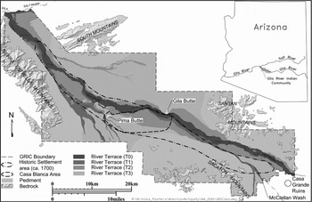
Although it is not currently possible to estimate Historic-period Akimel O'Odham populations exclusively using room count data, extensive ethnohistorical evidence exists regarding settlement patterns during this time. The missionary Kino was the first European to visit the people living along the middle Gila, making four trips there beginning in 1694 (Bolton Reference Bolton1948; Wilson Reference Wilson2014). Although variation in the number and locations of villages on the different maps he made has caused confusion, it is clear that settlement areas were documented along the middle Gila, and no villages were recorded along the lower Salt River (Ezell Reference Ezell1961, Reference Ezell and Ortiz1983; Russell Reference Russell1908). Wilson (Reference Wilson2014) concluded that the Akimel O'Odham settlements were restricted to an approximately 76-km stretch of the middle Gila, beginning about 12 km above the junction of the Salt and Gila Rivers and extending east to roughly 4 km from Casa Grande (Figure 3). Communities were dispersed along this portion of the river, and the houses were scattered in loose clusters that varied in size and density (Ezell Reference Ezell1961:110).
Historic-period Akimel O'Odham settlement areas and major landforms.

Between 1744 and 1775, Akimel O'Odhams further concentrated their settlements to the Casa Blanca area on the south side of the Gila River. Akimel O'Odham villages had become the target of more frequent raiding by the Apache and Yavapai during this time (Ezell Reference Ezell and Ortiz1983; Russell Reference Russell1908; Wilson Reference Wilson2014). To defend against these threats, Akimel O'Odhams adopted this denser settlement pattern, maintained mandatory military service for all males, and conducted punitive campaigns (Shaw Reference Shaw1994; Webb Reference Webb1959). By the late 1800s, however, the raiding began to abate and the Akimel O'Odhams returned to a more dispersed settlement pattern. Both ceramic and projectile point data from the GRIC support these observations of Historic-period Akimel O'Odham settlement patterns (Loendorf Reference Loendorf2012, Reference Loendorf2014).
Because Historic-period Akimel O'Odhams concentrated their settlements along a small segment of the middle Gila River for defensive purposes, many researchers have inferred that the remainder of the Phoenix Basin was abandoned or depopulated (Hegmon et al. Reference Hegmon, Howard, O'Hara, Peeples, Der and Fernandini2016; Hill et al. Reference Hill, Lyons, Clark and Doelle2015; Nelson et al. Reference Nelson, Kintigh, Abbott and Anderies2010). However, Akimel O'Odhams farmed fields across a larger area, and they extracted plant and animal resources from throughout the Phoenix Basin, which they defended as their territory (Hackenburg Reference Hackenberg1974).
The upstream diversion of water from the middle Gila that started in the 1860s resulted in repeated failures of the Akimel O'Odham crops (Dejong Reference DeJong2009; Wilson Reference Wilson2014). Some community members responded by abandoning irrigation agriculture altogether, and they took wage labor jobs. Others cut wood to sell to Phoenix residents. Some community segments, however, responded by reoccupying better-watered locations outside the original border of the GRIC. These areas were either further upstream on the middle Gila or to the north along the Salt River, and these migrants continued to practice traditional canal irrigation agriculture (Dejong Reference DeJong2009; Shaw Reference Shaw1994:58–65; Webb Reference Webb1959:38). Starting with the Spanish in the late 1600s, Christian missionaries had little success converting any Akimel O'Odhams, but during this time, when the community was extensively disrupted, most members became Christians (Wilson Reference Wilson2014). As described above, similar migrations and religious changes occurred earlier in time in response to prior socio-environmental disruptions.
Many additional commonalities exist between the Prehistoric and Historic periods within the Phoenix Basin. First, these include close correspondences in projectile point shape and serration data, as well as the uninterrupted trends in obsidian acquisition patterns that continued from the Prehistoric period (Loendorf Reference Loendorf2014; Loendorf et al. Reference Loendorf, Fertelmes and Lewis2013; Loendorf, Oliver, et al. Reference Loendorf, Oliver, Tiedens, Plumlee, Woodson and Simon2015). Second, Akimel O'Odhams practice a dispersed settlement pattern that is similar to Preclassic strategies (Ezell Reference Ezell1961:110–113; Fish Reference Fish, Cordell and Gumerman1989:21; Seymour Reference Seymour2011:198–209). Third, Akimel O'Odhams are dependent on irrigation agriculture, and their canal system shares close correspondences with both the Classic and Preclassic subsistence patterns (Ezell Reference Ezell1963:63; Ravesloot et al. Reference Ravesloot, Darling, Waters, Fisher, Hill and Feinman2009; Webb Reference Webb1959:121–126; Woodson Reference Woodson2016). Fourth, most Akimel O'Odhams believe that they are descendants of the prehistoric Phoenix Basin populations (Shaw Reference Shaw1994; Webb Reference Webb1959:53). Fifth, Akimel O'Odhams returned to making red-on-buff pottery, which requires wood for firing. This pottery has many similarities to prehistoric artifacts, including manufacturing technique (i.e., paddle and anvil), composition (e.g., type of clay), and style (Ezell Reference Ezell1963; Newman and Woodson Reference Newman, Woodson and Woodson2002). This ceramic construction technique rarely occurs elsewhere in the U.S. Southwest and northwest Mexico, and other methods such as coil and scrape are more prevalent outside the Hohokam region (Crown Reference Crown2001). Sixth, we have shown here that Akimel O'Odham cultural traditions are consistent with the archaeological record, which would not have occurred by coincidence (Lewis and Rice Reference Lewis, Rice, Rice and Czarzasty2009; Teague Reference Teague1993). Finally, during this interval people returned to building structures that are similar to Preclassic pithouses, which require substantially more wood for construction than adobe houses (Ezell Reference Ezell1963, Reference Ezell and Ortiz1983; Sayles Reference Sayles1938; Seymour Reference Seymour2011:97–138). These similarities led Sayles (Reference Sayles1938:83) to conclude: “Indications point strongly to the Pima as being the cultural descendants of the Hohokam. The analogy between the Pima type of single unit dwelling and that of the Hohokam is close.”
This reappearance of Preclassic period cultural traditions is reflected by the return of people from before the flood as symbolized in the Akimel O'Odham creation story. Recently, Ravesloot et al. (Reference Ravesloot, Darling, Waters, Fisher, Hill and Feinman2009) offered a new model for the Classic-period collapse that supports continuity in cultural traditions within the Phoenix Basin. They argue that the prehistoric populations entered a new adaptive cycle at the end of the Classic period, and the Historic Akimel O'Odhams represent a reorganized society. We agree, and suggest that similar reorganizations also occurred earlier in time.
Finally, this paper has focused exclusively on the Phoenix Basin, and the nature of relationships among populations in other regions, such as the Tohono O'Odhams and Tucson Basin Hohokams, is beyond the scope of this manuscript. We also recognize that Tohono O'Odham, Pee Posh (i.e., Maricopa), and other people immigrated to the Phoenix Basin during the Historic period (Loendorf Reference Loendorf2014; Russell Reference Russell1908; Spier Reference Spier1933; Wilson Reference Wilson2014). Because many of these populations moved from elsewhere in the Hohokam region to the middle Gila, they have maintained traditions regarding migration, as well as distinctions among themselves (Webb Reference Webb1959:22). Furthermore, this process of coalescence caused changes in social organization and material culture, and it may also have resulted in genetic variation from the prehistoric populations who lived along the middle Gila River (Loendorf Reference Loendorf2012). We maintain, however, that O'Odhams are the direct cultural and biological descendants of the prehistoric Hohokam inhabitants of southern Arizona.
Conclusions
Prehistorians have advanced many different models for cultural change in southern Arizona, and they have identified a wide range of factors as potential causes. These include such diverse mechanisms as migration, flood, drought, volcanic eruptions, variable solar output, ocean-atmospheric dynamics, social unrest, salinization, earthquakes, warfare, path dependencies, network size, and astronomical associations (Elson et al. Reference Elson, Ort, Hesse and Duffield2002; Graybill et al. Reference Graybill, Gregory, Funkhouser, Nials, Doyel and Dean2006; Haury Reference Haury1976; Hegmon et al. Reference Hegmon, Howard, O'Hara, Peeples, Der and Fernandini2016; Hill et al. Reference Hill, Lyons, Clark and Doelle2015; Huckleberry Reference Huckleberry, Ingram and Hunt2015; Loendorf Reference Loendorf2012; Masse and Espenak Reference Masse, Espenak, Doyel and Dean2006; Mills et al. Reference Mills, Clark, Peeples, Haas, Roberts, Hill, Huntley, Borck, Breiger, Clauset and Shackley2013; Nelson et al. Reference Nelson, Kintigh, Abbott and Anderies2010; Ravesloot et al. Reference Ravesloot, Darling, Waters, Fisher, Hill and Feinman2009; Redman Reference Redman1999; Tainter Reference Tainter1988; Woodson Reference Woodson2016). We agree that many factors conditioned cultural variation in the Phoenix Basin, and these theories are not necessarily mutually exclusive with the model presented here, which posits that cyclical overpopulation led to repeated vulnerabilities to socio-environmental constraints.
The Phoenix Basin occurs at the junction of two streams that have substantial variation in the topography and elevation of their drainage basins, differences that created divergent discharge regimes. Data presented here suggest that Holocene climatic variation alternately favored conditions for irrigation along the Salt and Gila Rivers. This, in turn, affected ideological, economic, and political relationships within the region (Loendorf Reference Loendorf2012:117–133). Economic and social responses, as well as changes in settlement patterns caused by a down-cutting episode around roughly A.D. 1100, resulted in a fundamental reorganization of Phoenix Basin populations. After the Classic period, conditions shifted back to favor the middle Gila, and Akimel O'Odhams returned to emphasizing practices that are highly similar to those of the Preclassic period, when the population was previously highest along that stream. Although the overpopulation and subsequent reorganization of ancestral communities can be characterized as a series of “collapses,” we believe that this cycle is more accurately seen as a sequence of cultural responses to changing conditions. By understanding that the Akimel O'Odhams are a reorganized society who survived and succeeded, we can stop denying these people their past and recognize that their prehistoric ancestors in the Phoenix Basin did not simply fail and collapse.
Recent research on the changes that occurred at the close of the Classic period has focused on archaeological remains from the lower Salt River, but any theory for the depopulation of this area also needs to take into account the evidence for the continuity of occupation along the middle Gila River. There is no dispute that Akimel O'Odhams were living along the middle Gila River when the first Euroamericans arrived in the late 1600s, and if these people are not directly related to the prehistoric inhabitants of the area, then the burden of proof rests on identifying where they came from and why their material culture is so remarkably similar to that of the Preclassic-period inhabitants of the region. Any explanation for the Hohokam collapse should be judged on the amount of data it accounts for, and we have presented a model based on Akimel O'Odham traditions that explains the periodic changes in cultural practices, as well as the continuity of populations over time.
Acknowledgments
This research was conducted as part of the Pima-Maricopa Irrigation Project, which is funded by the Department of the Interior, U.S. Bureau of Reclamation, under the Tribal Self-Governance Act of 1994 (P.L. 103–413), for the development of a water delivery system utilizing Central Arizona Project water. This paper would not have occurred without the support of M. Kyle Woodson, GRIC-CRMP Director. We also recognize the hard work of the field crew and the entire GRIC-CRMP staff who contributed to collection of the data on which this paper is based. These investigations were also overseen by John Ravesloot and J. Andrew Darling, who in turn directed GRIC-CRMP. Many thanks are due to Sylvia Walters for translating the abstract into Spanish, and to Nora Franco for checking it. Comments provided by three anonymous reviewers also provided essential insight for improving this paper. Last but not least, Lynn Simon provided invaluable assistance by producing the maps.
Data Availability Statement
All information employed in this paper is derived from the cited sources, and data presented here may be used with reference to this manuscript.