

Investigating Hoards And Single Finds
Prehistorians have studied collections of Bronze Age metalwork for over a hundred years. Single finds played an important part in their research, but the main emphasis has always been on the groups of artefacts described as ‘hoards’.Footnote 1 They were investigated on the premise that the contents of these assemblages would provide a cross-section of the objects that were available at any one time.Footnote 2 Despite some problems, this method allowed the artefacts to be assigned to a series of industrial phases whose validity has been confirmed by radiocarbon dating.Footnote 3 That procedure did not depend on knowing where the hoards had been found. What mattered was that the contents of these collections had been kept together after their discovery. To a large extent the same applies to studies investigating the composition of these groups.Footnote 4
Hoards were also used to reconstruct prehistoric technology. Together with casting waste and unfinished artefacts, many contained broken objects that might have been collected as scrap. For that reason they were associated with the activities of smiths or founders.Footnote 5 At one time it was suggested that bronze working took place away from settlements because so much fuel was needed.Footnote 6 With some notable exceptions,Footnote 7 that idea influences most practice in public archaeology, for the evidence of metalwork hoards plays little part in the planning process. As a result, archaeologists have not studied the siting of hoards in sufficient detail. The overall distribution of these finds seemed to be more significant than their individual locations.
Now that more is known about the chronology of Bronze Age metalwork, new questions can be asked. Why were so many objects deposited and never recovered, and why are certain types found in hoards whilst others are in different contexts? It was once supposed that the finds resulted from the storage, concealment and loss of valuable materials. That idea has been questioned.Footnote 8 At the same time archaeologists were unable to decide whether the deposition of metalwork should be interpreted in practical terms and looked for ways of distinguishing between ‘votive’ and ‘utilitarian’ deposits.Footnote 9 These discussions focused on two issues: were the hoards directly associated with the transformation of metals by a smith, and could the artefacts have been retrieved once they had been deposited?
Those questions involved some unwarranted assumptions. One was that the working of the metal was a purely technological process, carried out for entirely practical reasons and not accompanied by ritual. That is not consistent with ethnographic accounts of metalworking, which suggest that it can involve knowledge that is not generally available. It can take place at special locations and is attended by arcane rules.Footnote 10 Some of the metal can be deposited as an offering by the smith. The social anthropologist Mary Helms expresses the point by suggesting that powerful materials taken from the earth had to return to the earth to ensure that life would continue.Footnote 11 Her argument would mean that the deposits associated with prehistoric bronze working should not be described as ‘utilitarian’.
Rituals were inferred when artefacts were deposited in contexts from which there was no prospect of retrieving them.Footnote 12 That seemed logical twenty years ago, but it was too easy to assume that where artefacts could have been recovered they might be mundane deposits. There is some evidence to the contrary.Footnote 13 Objects that possess a special significance may remain untouched because contact with them is forbidden.Footnote 14 On the other hand, the fact that artefacts were buried and never recovered cannot show that these deposits were meant to remain untouched, since other hoards could have been dug up again.Footnote 15 A fresh approach to the problem is required.
Fontijn has shown that finds of different kinds of objects are associated with different parts of the landscape of the southern Netherlands.Footnote 16 Thus sickles and pins are associated with settlements, whilst spearheads and axes were deposited in streams and marshes. Swords and the most elaborate personal ornaments were placed in rivers even further away from where people lived. Hoards are usually classified according to the kinds of artefacts they contain. It is equally important to analyse these collections in relation to where they were found. It remains to be seen whether this example is typical, for certain locations might have been chosen for hoards because their positions would be easy to find. In Denmark, for instance, some were buried beside conspicuous rocks and others in natural mounds.Footnote 17 The contexts of these deposits need careful investigation.
The siting of Bronze Age hoards in Britain has rarely been considered in much detail. A ready supply of fuel was seen by early researchers as the main criterion for site selection.Footnote 18 Metal was rarely worked inside the settlements, perhaps because the process gave off fumes and there was a risk of fire. Even where hoard sites have been excavated, fieldwork has been limited to very small areas. As a result the few hoards found in settlements have been studied in a wider context,Footnote 19 while the others still remain in limbo.Footnote 20
Now, however, the results of developer-funded fieldwork have raised the possibility that bronze artefacts were deposited just outside the settled area. Some were associated with their earthwork boundaries. Another possibility is that metalwork hoards were deposited close to the burnt mounds of the same period. That is not to suggest that these structures were used by smiths. Rather, both hoards and piles of fire-cracked stone seem to have been located in a restricted zone beyond the living area.Footnote 21 Recent excavations suggest that metalwork might also be deposited within field systems, or just outside their limits.Footnote 22
There are indications that Bronze Age hoards were also associated with features of the natural landscape. Some of this work has been based on published sources, but more has taken place where hoards have just been discovered, often by metal detectorists. This research suggests that a number of important collections of Bronze Age metalwork come from hilltops, passes, caves, streams, springs and prominent rock formations.Footnote 23 Because the discoveries are widely scattered, it is hard to know whether these observations have a wider application. They suggest that a topographical approach to metal finds is useful, but ideally it should examine the finds from a single region.
A useful model is provided by a recent study of Late Iron Age metalwork in East Anglia.Footnote 24 It considers some exceptionally rich collections. For a long time they were interpreted as stores of valuables, concealed during times of crisis. Recent research sheds fresh light on this issue, for it has shown that in the second century bc the artefacts were usually deposited in the same kinds of location: on high points in the landscape or in places close to water. Again the choice of sites followed certain conventions, suggesting that these were sanctuaries rather than hiding places.
Characterizing The Findspots Of Bronze Age Hoards
Until recently it would have been difficult to take a similar approach to Bronze Age hoards, but the situation is changing. There has been an increase in finds, many of them documented by the Portable Antiquities Scheme (PAS), and much archaeological fieldwork has taken place as part of the planning process. This has led to some discoveries of metalwork, but more important is the light it sheds on the prehistoric landscape. Large-scale excavation has led to the identification of settlements, land boundaries and field systems across a larger area than had earlier been suspected.Footnote 25 It suggests that the findspots of hoards were not as isolated as they had seemed.
This paper builds on these developments. On one level it is inspired by fresh approaches to the archaeology of metal hoards. On another, it takes advantage of the increasing number of new discoveries, as well as the results of developer-funded fieldwork. It has two objectives. The first is to characterize the findspots of a large number of Bronze Age hoards. Did the choice of locations follow any pattern? The second is to assess the usefulness of different methods for investigating the places where such collections were found. Which were most effective, and which had limitations? Analysis of the findspots can shed light on the character of metalwork deposits themselves, but it is equally important to predict where further discoveries will occur. The object of the exercise, nevertheless, was to characterize the findspots of hoards that had already been found. No attempt was made to excavate new examples.
The study area
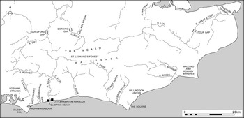
This paper considers all the provenanced finds of Bronze Age metalwork in south Hampshire, Sussex and parts of Surrey and Kent (fig 1). By this means it is possible to look at the pattern of deposition in the Weald, along the watercourses crossing the study area, and on the coastal plain between the downland and the sea. The study area offers several other advantages. There are many findspots to consider, and a number of hoards have been discovered recently and recorded by the PAS. The same region has seen a rapid expansion in the scale of archaeological fieldwork. It sheds new light on the organization of the prehistoric landscape, and the evidence for Bronze Age settlements and field systems has recently been assembled by one of the authors.Footnote 26
The location of the study area, with the chalk of the North and South Downs indicated in black

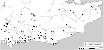
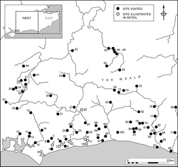
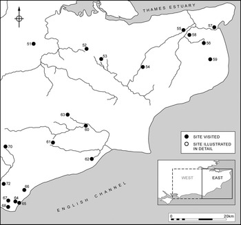
A hundred sites were visited in the project presented here (fig 2), and the records of other finds were consulted. Both single finds and hoards were investigated in this research. Most of the visits were to findspots where the quantity of metalwork discovered varied from two items up to the 185 discovered at Crundale, in Kent (site 54). The Treasure Act applies to finds of two or more prehistoric base-metal finds. Coroners, mindful of advice from archaeologists, may judge that repeated discoveries of single finds are the contents of dispersed hoards. They are considered to be Treasure. The discoveries at Chislet (site 55) fell into this category. The hoards and single finds were of Middle and Late Bronze Age dates. Most were dominated by tools and metalworking residues.
The Middle and Late Bronze Age hoard sites visited during fieldwork

Sources of information
The work drew on a number of different sources. The most important was the local Historic Environment Record (HER). The primary references in the HER were also consulted. Normally each office maintains files for the sites, which may contain further information (for example, a letter from the finder). The HERs describe the artefacts but contain less information about their contexts. The records of the PAS were invaluable; its national database provided the greatest number of precisely provenanced hoards.Footnote 27 County Finds Liaison Officers provided access to new finds, copies of Coroners’ Reports under the Treasure Act and a protocol for approaching the original discoverers and obtaining access to farmland. Some of the findspots are not in the public domain and cannot be described in this article, but they were visited in the course of the research.
Field methods
If deposits of Bronze Age metalwork were closely allied to settlements it should be possible to demonstrate this by conventional methods. Work in West Sussex had already established the value of field walking on cultivated land. It had shown that hoard sites might be located towards the limits of surface scatters of later prehistoric worked flints.Footnote 28 This material could not be dated accurately because it included few diagnostic artefacts. Pottery did not survive on the surface, but it might remain intact where it was not exposed to weathering. For that reason one approach was to combine surface survey with the excavation of test pits to look for ceramics. Because there were also indications that hoards might have been near to burnt mounds, the distribution of fire-cracked flints was recorded. Where the hoard sites were in pasture or woodland other techniques were employed. Domestic sites could be located by geophysical survey, and deposits of burnt flint could be detected by coring. Additional information was provided by the results of excavations carried out by other people. Some were near to places where metalwork had already been found, and a few resulted in new discoveries.
These methods were used alongside another kind of analysis. This was based on the topography of the findspot. It could be employed where other kinds of evidence were absent. The work was helped by the study of early maps. Every attempt was made to examine the findspots on the ground and to investigate areas containing a number of different hoards. Only by considering the largest possible sample would it be possible to document any general patterns.
Part One: The Contribution Of Intensive Survey Methods (with David Dunkin)
Field walking
It was planned to carry out extensive field walking, but, in the event, not many of the hoard findspots were cultivated. Shortened fallow times restricted the number of sites that were ploughed during the lifespan of the project (their locations are shown in fig 7, together with those investigated by other methods).
Systematic field walking was undertaken at five sites: three on the coastal brickearth, one on the chalk and one on the Lower Greensand of the Weald. Each survey collected a 10 per cent sample of surface finds. At sites on the coastal plain it became clear that the metalwork had been deposited in an area of intensive prehistoric activity, evidenced by concentrations of worked and fire-cracked flint.
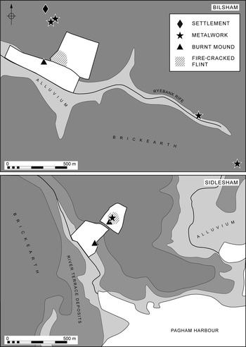
At Bilsham (site 5), 9ha were investigated (fig 3, upper). Two late prehistoric sherds were recovered, but 470 worked flints were collected. Fire-cracked flints covered the entire field, increasing in volume close to the position of a burnt mound. Subsequent ploughing showed that similar material extended towards the edge of a palaeochannel close to where a Middle Bronze Age hoard had been found.
The distribution of burnt flint, burnt mounds, worked flint, metalwork and settlement sites at Bilsham (after Dunkin Reference Dunkin2001) and Sidlesham. The unshaded areas enclosed by a broad line were investigated by field walking

At a second site at Sidlesham (site 9), a 10 per cent systematic field-walking survey was undertaken around the position of a Late Bronze Age hoard (fig 3, lower). In this case there was a concentration of burnt flint 30m to its south.
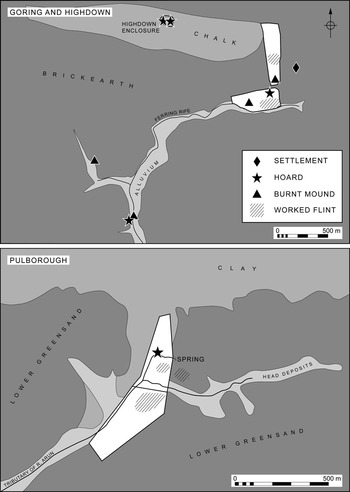
At Goring (site 17), two field blocks were walked to investigate the context of a Late Bronze Age hoard (fig 4, upper). The first survey covered a 9ha field immediately west of the findspot. It produced four sherds of later prehistoric pottery and 153 worked flints. Again fire-cracked flints were spread across the entire field, but there were greater concentrations toward the edge of a palaeochannel. The second survey block investigated a 12ha field immediately north of the findspot. There was little later prehistoric pottery, but seventy-nine flint implements were recovered together with a large amount of fire-cracked flint. The greatest concentration of burnt stone was within 100m of the hoard.
The distribution of worked flint, burnt mounds, worked flint, metalwork hoards and settlement sites at Goring, Highdown and Pulborough, West Sussex. The unshaded areas enclosed by a broad line were investigated by field walking

On the southern edge of the downland an area of 12.5ha was investigated around the findspot of a Late Bronze Age hoard at Sompting (site 96). It produced three sherds of prehistoric pottery and 667 worked flints. Burnt flint also occurred.
The high density of artefacts on the Sussex coastal plain was not matched in a smaller area surveyed around the findspot of a Middle Bronze Age hoard at Pulborough (site 26) on the Lower Greensand (fig 4, lower). No surface prehistoric pottery was found and there were only thirty worked flints, most of them Mesolithic. Total collection produced very little fire-cracked flint. Another field, located 300m further to the south, produced no pottery at all, but here there were forty-five worked flints and 3kg of burnt flint.
Thus sites on, or overlooking, the Sussex coastal plain all produced concentrations of worked flint of later prehistoric character, together with large quantities of fire-cracked flint. In two instances settlements had already been recorded nearby. In all four cases there was enough evidence to suggest that the hoards had been deposited within the settled landscape. These surveys indicated the proximity of burnt mounds. That was also true of the one site investigated on the Lower Greensand.
Test pitting
Test pits (1m by 1m) were dug close to the findspots of four metal hoards. This provided an opportunity to see whether pottery survived below the surface. The method was effective at Bilsham (site 5) where Middle or Late Bronze Age sherds were found in an alluvial deposit covering a burnt mound. At one site at Pulborough (site 26) small quantities of burnt flint were located close to a stream, and at Wilmington (site 72) test pitting produced tiny sherds of undiagnostic later prehistoric pottery near the findspot of a Late Bronze Age hoard.
Coring
Test pitting was supplemented by a programme of coring. At Bilsham (site 5) it was used to trace the extent of a burnt mound and at Pulborough (site 26) the auger holes allowed samples to be recovered from the stream bed, where small quantities of fire-cracked flint were found. The core samples also helped to map palaeochannels and the edges of deposits of alluvium close to metalwork hoards.
Geophysical survey
At Sidlesham (site 9) the geophysical survey did not locate any buried features, but at Ferring (site 18) it identified a palaeochannel close to a Late Bronze Age hoard. At Pulborough (site 26) there were amorphous anomalies (possibly small pits) but no signs of any regular structures below the surface. The anomalies were examined by test pitting but no finds were made. At these sites, hoards are unlikely to have been deposited inside settlements.
Developer-funded excavation
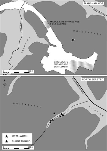
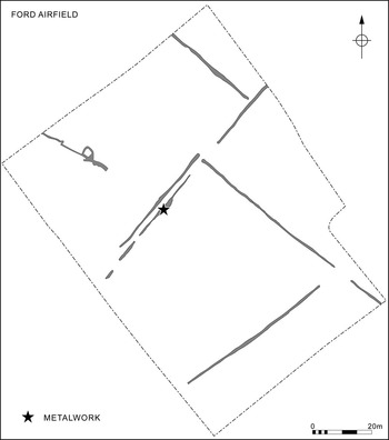
This is one of the most effective ways of investigating metalwork deposits. At Bognor Regis Community College, North Bersted (site 1), topsoil was cleared from the site of a Late Bronze Age hoard found in 1956. It showed that the artefacts had been located near to a boundary ditch.Footnote 29 At Flansham (site 7) fieldwork revealed areas of Late Bronze Age occupation and land divisions close to another hoard site (fig 5, upper).Footnote 30 Clearance of topsoil at Persimmons, North Bersted (site 2), showed that four palstaves had been deposited by a palaeochannel (fig 5, lower). There was a series of burnt mounds within 50m of the findspot.Footnote 31 At Ford (site 19) another palstave had been placed in the upper filling of a ditch belonging to a coaxial field system (fig 6).Footnote 32
The distribution of burnt mounds, finds of metalwork and settlement sites at Flansham Hoe and North Bersted, West Sussex. The unshaded area enclosed by a broken line was investigated by excavation. Information from Wessex Archaeology, Archaeology South-East and Thames Valley Archaeological Services

The location of the palstave found within a Bronze Age field system at Ford Airfield. Information courtesy of Archaeology South-East

At South Heighton (site 86), where a Late Bronze Age hoard had been found, there were elements of a similar field system. At Drayton Lane, Oving (site 8), a palstave had been deposited close to cremation urns, a burnt mound and a palaeochannel.Footnote 33 Similarly, a hoard at Northbrook College, Goring (site 17), was within 150m of a Middle or Late Bronze Age settlement.Footnote 34 Again it was associated with burnt mounds.Footnote 35 These were chance discoveries, but they lend weight to the evidence collected in our own fieldwork.
There are fewer examples away from the coastal plain, where most commercial development has taken place. On the downland, a Sussex Loop was found in a small pit containing fire-cracked flint at the end of a chalk spur at Lavant (site 14).Footnote 36 Beside the River Arun, developers found a dress pin and Late Bronze Age pottery in a possible well,Footnote 37 and on the southern edge of the Weald a Late Bronze Age gold hoard was located at Fitzleroi Farm, Fittleworth (site 27). A series of pits was identified in subsequent excavation.Footnote 38 The pottery found in the course of these projects was not sufficiently diagnostic for its chronology to be compared directly with that of the metal finds, nor are any radiocarbon dates available.
Discussion
The field methods adopted by the writers have a disadvantage. They relate the positions of known hoards to scatters of domestic artefacts, but the surface finds are difficult to date. Despite the use of test pitting, virtually no diagnostic sherds were recovered. For that reason it is not possible to compare the finely calibrated sequence of metal hoards with the coarser chronology provided by field survey. The evidence of test pitting raises another problem, for this method has produced large numbers of later prehistoric worked flints and very small quantities of pottery, even from the lower levels of ploughsoil, where it might be expected to survive. Given the large number of vessels associated with excavated settlements, it seems possible that the findspots that were investigated were near to the limits of the occupied area but actually lay outside it. The artefacts may have been accumulated as manuring scatters in which pottery would not have survived exposure to the elements.
The limited body of excavated evidence points to the same conclusion. In this case finds of metalwork seem not to be associated with the living sites, but with the field ditches, cremation cemeteries and burnt mounds in the vicinity of those sites. A consistent feature of both kinds of study is the association between Bronze Age hoards and palaeochannels. This relationship was somewhat unexpected and the best way to investigate it was by topographical analysis of the places where artefacts were buried.
Part Two: The Contribution Of Topographical Survey
One aim of the research was to visit all the accessible findspots of well-provenanced hoards. It soon became apparent that these places had much in common with one another, and as more sites were examined on the ground it was clear that the hoards were not located at random.
Topographical information was rarely provided in accounts of these finds. It had to be acquired by examining the sites on the ground. In most instances the area around the hoard sites was visited several times as new information emerged on air photographs, soil surveys or historical maps. It was only then that the potential significance of certain natural features became apparent. It was still more evident as the sample of sites increased.
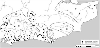
The most striking pattern was the association between finds of metalwork and sources of fresh water: rivers, streams and springs. That connection also extends to the alluvial channels crossing the West Sussex coastal plain. At the same time, there are differences in the placing of hoards and other finds from one region to another, so the study area cannot be discussed as a single unit. For that reason the results of topographical analysis are divided into eleven separate sub-sections which follow the main rivers, streams and their tributaries. It is important to set out the field evidence one region at a time, for some of the most striking local patterning would be lost in a more general summary.
The following account presents the evidence from these different regions (figs 7, 8 and 9). It begins with finds on the West Sussex coastal plain, and then follows the main watercourses extending into the Weald. It describes the results of fieldwork in that area, before considering selected hoards in Kent. Finally, it considers the metalwork found close to the Channel coast in east and mid-Sussex. The numbering of findspots follows the same arrangement. All the sites are named in an extended caption to these maps, but National Grid references are not provided in order to protect these places from unauthorized excavation. A few of the one hundred hoards are not referred to individually because visits to the findspots were inconclusive.
The sites with finds of metalwork visited in the course of the project. Key: 1. North Bersted (Bognor Regis Community College); 2. North Bersted (Persimmons); 3. Aldingbourne; 4. Yapton; 5. Bilsham; 6. Middleton on Sea; 7. Flansham; 8. Oving; 9. Sidlesham; 10. Apuldram; 11. Funtington; 12. Funtington (Bosham Stream); 13. Havant; 14. Lavant; 15. Elsted; 16. Highdown; 17. Goring; 18. Ferring; 19. Ford; 20. Madehurst; 21. Binsted; 22. Clapham; 23. Arundel; 24. Houghton; 25. Storrington; 26. Pulborough; 27. Fittleworth; 28. Lower Beeding; 29. Chiddingfold; 30. Fernhurst; 31. Duncton; 32. Buriton; 33. Langrish; 34. Hawkley; 35. Colemore and Priors Dean; 36. Liss; 37. Whitehill; 38. Woolmer Forest; 39. Blackmoor; 40. Binsted; 41. Headley Down; 42. Guildford; 43. Betchworth; 44. Reigate 1; 45. Reigate 2; 46. Reigate 3; 47. Reigate 4; 48. Reigate 5; 49. Charlwood; 50. Newdigate; 51. Offham; 52. Hollingbourne; 53. Lenham; 54. Crundale; 55. Chislet; 56. Ringlemere; 57. Ebbsfleet; 58. Preston; 59. Tilmanstone; 60. Newenden; 61. Mountfield; 62. Pett; 63. Hawkhurst; 64. Eastbourne, Mill Gap Road; 65. Eastbourne, Terminus Road; 66. Shinewater; 67. East Dean, Pea Down; 68. East Dean, Sheep Farm; 69. Framfield; 70. Heathfield; 71. Berwick; 72. Wilmington; 73. Slaugham; 74. Handcross; 75. Ardingly; 76. Newick; 77. Barcombe Mills; 78. Plumpton Plain; 79. East Chiltington; 80. Clayton; 81. Lewes, Hope in the Valley; 82. Lewes, Malling Down; 83. Lewes Brooks; 84. Firle; 85. Iford; 86. South Heighton; 87. Newhaven; 88. Lewes, Chyngton Lane; 89. Brighton, Coldean Lane; 90. Brighton, Varley Halls; 91. Hollingbury; 92. Ditchling Common; 93. Cowfold; 94. Bramber; 95. Sompting, Halewick Lane; 96. Sompting, Lyons Farm; 97. Sompting, Cokeham Lane; 98. Chanctonbury; 99. Sompting, Stump Bottom; 100. Southwick, Mileoak Farm

Sites with finds of metalwork visited in the course of the project (continued)

The eleven regional groups of hoard sites considered in the text

Watercourses and other features associated with finds of metalwork

Area A: the Aldingbourne Rife, Sussex, sites 1–7
Loess or ‘brickearth’ deposits mantle large parts of the Sussex coastal plain, where they are cut by the small streams called ‘rifes’. The distribution of metalwork was closely associated with these watercourses. The account commences with this area (fig 10).
The distribution of metalwork finds and burnt mounds along the Aldingbourne Rife and its tributaries

Eighty Middle Bronze Age palstaves were found at Marshall Avenue, Bognor. The site is within a kilometre of the hoard at Bognor Regis Community College (1) mentioned earlier. Another discovery was at Persimmons Land (2) where a group of palstaves was identified 30m from the edge of a rife. A hoard of axes, spearheads and ‘items of jewellery’ reported to the PAS was found beside a tributary of the rife.
In the upper reaches of the Aldingbourne Rife, the PAS records a Late Bronze Age penannular gold ring and a hoard that includes a fragmentary ingot and parts of at least two axes (3). The area was settled during the Bronze Age, with a series of enclosures at Lidsey. Not far away a burnt mound is exposed in the bank of the channel.
Some 3km north of Lidsey the coastal plain meets the South Downs. At Long Down, Eartham, there is a chalk spur in between two dry valleys leading to the Aldingbourne Rife. Two socketed axes and metalworking debris have been discovered here. Further west, part of another socketed axe came from Halnaker.
At Barnham, eight palstaves were found by an alluvial arm of the Aldingbourne Rife. At Yapton nearby, there was a Late Bronze Age hoard containing eight socketed axes, six rings and copper cake (4). Close to Bilsham along the stretch of the Ryebank Rife, finds of a fragmentary ingot and another palstave hoard were discovered (5). A socketed gouge was found further to the east, by a stream feeding the Ryebank Rife (6).
Flansham Hoe forms a peninsula jutting out into the widest point of the Aldingbourne channel. The Late Bronze Age hoard from Flansham includes tools, weapons and ingots (site 7; fig 5, upper). Unlike most findspots in the vicinity, it does not overlook running water. Just south west of the hoard site there was a Bronze Age settlement and field system.Footnote 39 There are further finds of metalwork between Flansham and the coast.
Summary
Here Middle Bronze Age hoards contain palstaves, sometimes to the exclusion of other types of artefact. The same emphasis on deposits of axes continued into the Late Bronze Age when the hoards were located further from the watercourses. Now these items were combined with other kinds of artefacts. There are sword fragments from two collections deposited within field systems; in each case they form part of a larger assemblage. Most of the metalwork was close to channels of clear, fresh water. There were settlements near two of the hoards. Hoards are also associated with the remains of burnt mounds.
Area B: the River Lavant, Selsey Bill and the south Hampshire coast, sites 8–15
Again the findspots are similar. The edges of the rifes are obviously important, and here the metalwork is often associated with mounds or other deposits of burnt flint. For example, at Drayton Lane, Oving (8), a palstave was found with a small group of pottery vessels within 20m of a burnt mound.Footnote 40 There is a palaeochannel of the Pagham Rife nearby. Field walking identified another concentration of burnt flint 30m south of the Middle Bronze Age hoard at Rookery Farm, Sidlesham (site 9; fig 3, lower). A burnt mound was also found on the margin of a former inlet of Pagham Harbour.
At Apuldram Sewage works a socketed axe was found in the river itself (10). Here the Lavant consists of a fan of swampy ground with extensive reed banks. There are two other findspots at West Ashling, Funtington (11 and 12). One produced a hoard with small spearheads, ornaments and a saw fragment. It occupied a low promontory extending into an area of wetland where the Bosham Stream contained a spearhead. In the same way, there were two adjacent findspots in the grounds of Southleigh Park House, Havant (13). Each was close to a pond and a spring.
Finds along the River Lavant were also investigated. A Sussex Loop was found in a small pit at Lavant Reservoir (14). Further to the north, four Middle Bronze Age palstaves come from Beacon Hill, Elsted (15). The hilltop was enclosed at the end of the Bronze Age when two penannular gold rings were deposited in its entrance.Footnote 41
Summary
Again there was a close association between watercourses, burnt mounds and finds of metalwork on the coastal plain. There is also a little evidence that finds of ornaments were further inland than some of the other deposits.
Area C: Littlehampton and the Rivers Arun, Stor and Rother, sites 16–36
There appears to be a ‘dendritic’ pattern of deposition along the River Arun and its tributaries. For 20km the river system is tidal and is characterized by saline or brackish water. Sea levels have changed since the later prehistoric period, and today fresh water is confined to the upper reaches, minor tributaries and springs. It is here that most of the metalwork is found.
There are fewer finds of bronzes near the modern coast. Most have been found along Climping beach, although a palstave is said to have been dredged from Littlehampton harbour. The coastal plain is dominated by Highdown Hill (site 16; fig 4, upper). This was a Bronze Age enclosed settlement, although the structural sequence is unclear.Footnote 42 A socketed knife was found in a pit, and a bronze hoard comes from the same site. Immediately south of the hillfort is the Ferring Rife. Two more hoards are reported along this stream. One (17) is within 150m of a Middle and Late Bronze Age settlement and was associated with burnt mounds.Footnote 43 The second, on the Ferring Rife (18), was also near a burnt mound. Field walking around the findspot led to the discovery of another burnt mound beside a palaeochannel.
There is evidence of Bronze Age of coaxial fields, enclosures and droveways on both sides of the Ferring Rife.Footnote 44 They include a field system at Ford Airfield where a palstave has been found in a boundary ditch (site 19; fig 6). Just north of Ford, a seasonal watercourse may have extended northwards to the edge of the Weald. A single find of a palstave was associated with its likely source. From there a valley system extends down to Madehurst (20) where two palstave fragments and ten pieces of scrap are recorded. The finds were 50m west of an earthwork enclosure. The area between the findspot and the earthwork is strewn with later prehistoric cores and flakes and with fire-cracked flints.
An alluvial arm of the same watercourse runs past Binsted (21) before joining the Arun. South east of Binsted, a socketed axe and part of another axe were found at separate locations beside this stream. Finds on the east side of the River Arun are not dissimilar, with the discovery of a dress pin plus Late Bronze Age pottery in a possible well near to a palaeochannel. At Clapham, a Sussex Loop was discovered at the source of another stream (22). There were two burnt mounds nearby.Footnote 45 Further downstream, there was a single find of a palstave.
From Arundel northwards, the river drains through a gap in the chalk downland. The waters are both brackish and saline, but fresh water enters the river north east of the town. Not far upstream, palstaves were found on a low bluff overlooking the stream (23). On the other side of the river a biconical gold pendant comes from Houghton (24). It was on the northern edge of a deep V-shaped valley running down to the river.
The tributaries of the Stor and Rother meet near Pulborough. Each is fed by springs along the scarp of the South Downs. The Stor rises at Storrington, where a major Late Bronze Age hoard was found (25). A Later Bronze Age field system has been identified nearby.Footnote 46
The present tidal limit of the Arun is close to Pulborough, where fieldwork was carried out at the findspot of a hoard of palstaves found downstream from a spring (26). In this case it seems as if the metalwork was located in between two settlements (fig 4, lower). Traces of burnt flint in the stream suggest that there had been a burnt mound here. Where the Pulborough stream joins the main channel on the opposite bank of the Arun, there is another small spring near Fittleworth (27). Here a Late Bronze Age gold hoard was located on the watershed between a valley draining down to the Rother to the west and another overlooking the Arun. Further north, the Arun has produced fewer finds, but their locations follow a familiar pattern. Axes from Lower Beeding (28) were found near a feeder stream; here the surrounding soil apparently showed signs of fire. Another site in the upper reaches of the Arun was also investigated: the findspot of a palstave from Chiddingfold (29).
To the west, the River Rother runs parallel to the scarp of the South Downs and is fed by streams issuing from the junction of the Upper Greensand and Gault Clay. Here a palstave was discovered at Fernhurst (30) beside a tributary of the river. There was a similar find at Duncton (31) where worked flint of later prehistoric character can be found on the surface.
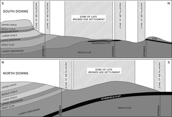
There were a number of metalwork deposits close to the source of the Rother. At Buriton (32), a palstave was found on the edge of a steep-sided valley cut into the Upper Greensands by another spring. There is a cluster of three finds at Langrish (33), two of which are on sloping ground where water collects at the junction of the Lower Chalk and the Upper Greensand (fig 11). A Middle Bronze Age annular bracelet was also found overlooking this area and was reported to the PAS.
Idealized cross-sections of the South and North Downs indicating the areas favoured for Bronze Age settlement and the relationship between springs and finds of metalwork

Five kilometres further north, an ingot hoard and a rapier were found at Hawkley (34). The findspot was at the start of a deep gully which cuts through the chalk to the Upper Greensand to join the main channel of the Rother close to where a palstave and two bracelets were discovered (36).
Summary
In common with the areas already described, the Arun and Rother illustrate a dendritic pattern of deposition in which tools are placed by fresh-water tributaries of the principal rivers. Their distribution avoids the brackish major channels, but environmental evidence is needed to show whether this was the case in the past. Several hoards seem to have been found near to burnt mounds or Bronze Age field systems, and there are also finds from what may have been a defended enclosure. The distribution of metal artefacts suggests the special importance of the Lower Greensands and the associated spring lines. The relatively few deposits containing personal ornaments place less emphasis on the coastal plain than the other finds of metalwork.
Area D: the Wey–Godalming hydrology, sites 37–42
The sources of the Rother and the Wey are close to one another, but different kinds of metalwork are associated with each of the rivers. The Wey flows northwards into the Thames Valley and is dominated by finds of weapons. That is not true of the Rother. Nevertheless metalwork was deposited in similar places in both areas. Several findspots were on the edge of the catchment of the Wey: for instance, Whitehill (37) and Woolmer Forest (38) at the end of an alluvial spur. Another example is a hoard from Blackmoor (39). They are poorly provenanced antiquarian finds. One PAS find was located by a fresh-water spring. An annular bracelet was found at Binsted (40), where the findspot was close to a tributary of the Wey.
The river cuts through the North Downs at Guildford. There have been significant discoveries along the spring line at the base of the chalk scarp (site 42; fig 11). The metalwork from these springs includes palstaves, socketed axes and fragments of swords and spears.
Summary
The positioning of the hoards shows the familiar association with springs and the headwaters of fresh-water streams and rivers. Towards the Thames Valley the metalwork includes a higher proportion of weapons.
Area E: the escarpment east of Dorking, Surrey, sites 43–50
Dorking is in the next cutting through the Downs. Again deposits of metalwork follow the spring line. At Betchworth (43), a number of deposits have been found in the same area. They include palstave fragments, swords and socketed axes, although in this case there was more evidence of metalworking debris. Fresh water flows from these springs into the Mole.
The river runs westward to the Dorking Gap, where fresh water from Reigate joins the main channel. There is a large alluvial basin below the town. The area is characterized by several single finds of metalwork (44–48). Two weapon fragments were found on the slopes of a prominent greensand ridge, and the other finds were of metalworking debris – one was close to the Wallace Brook, and the other two in the valley of a small stream feeding the Mole. Again the locations of these deposits may have been influenced by the presence of local springs.
Prior to the introduction of the PAS, little was known of metalwork along the Mole valley. In 1952, a Hallstatt C sword was recovered from the Polesfleet Stream at Charlwood (49). The findspot is on the eastern edge of a wide expanse of alluvium. There is little evidence of other kinds, but the wider region certainly was occupied, as fieldwork 1.5km north of the findspot revealed an enclosed Late Bronze Age/Early Iron Age settlement on a promontory extending into the wetland.Footnote 47 A socketed axe fragment from Newdigate (50) was found just below a spring, the waters of which join the Mole.
Summary
The deposition of metalwork along the North Downs escarpment resembles the pattern observed at the base of the South Downs. Again springs were very important, and the gap through the high chalk provided another focus for the deposition of metalwork.
Area F: metalwork hoards in Kent, sites 51–59
Fieldwork in Kent reveals a close association between metalwork deposition and the spring waters of the Lower Greensand/Chalk escarpment. In recent years a number of Late Bronze Age hoards have been reported along the scarp slope between the Medway and the Great Stour. All the findspots were visited during this research. Each hoard has a dependable provenance, and was located along the river system linking the Weald to the coast.
At Hollingbourne (52), thirty-five metal artefacts were recovered belonging to the Carp’s Tongue industrial phase. They were buried close to the source of the River Len, a tributary of the Medway. Similarly, metalwork of both Middle and Late Bronze Age date was found at Lenham, on a promontory beside the source of the Great Stour (53).
Where the Great Stour cuts through the North Downs at Crundale, Kent’s largest hoard was discovered (54). One hundred and eighty-five items were recovered, including complete and fragmentary tools, razors and weapons. From there, the river runs down to join the Wantsum Channel at Chislet where metalwork has been found by a fresh-water stream entering the main channel of the Stour (55). There is the same association with a fresh-water stream at Ringlemere, where a Late Bronze Age hoard was discovered (56). Finally, on the Ebbsfleet peninsula, where the Great Stour discharges into the sea, there have been recent discoveries of Late Bronze Age metalwork (57).Footnote 48
Summary
These finds extend the pattern examined in greater detail in other parts of the study area and illustrate the same emphasis on springs and the confluences of streams and rivers. Another focus was where a river cut through the chalk escarpment.
Area G: the River Rother on the Kent–East Sussex border, sites 60–63
The Rother is the main drainage channel extending from the Weald towards the Walland and Romney Marshes. There are few metal finds along its course, but a spearhead was dredged from the river opposite Newenden (60). Further finds along the fresh-water feeder streams fit the pattern of deposition seen elsewhere.
At Mountfield, in East Sussex (61), a hoard of Late Bronze Age gold ornaments was ploughed up in 1863. This findspot is on a promontory overlooking a series of streams flowing north to the Rother. Two recent discoveries are from similar locations, and at Pett (62) three palstaves were found within 40m of a pond on the end of a promontory overlooking a stream (fig 12). The site, which is situated by the head of a valley, occupies clay which would have been difficult to cultivate.
At Hawkhurst, in Kent, a series of finds were made in an open field bounded on either side by fresh-water streams (63). Again the location is unusually wet.
Summary
Again the finds of metalwork were deposited close to fresh running water, but the sites were sometimes on areas of high ground. They were also located on soils which would have been unsuitable for settlement.
Area H: Eastbourne, the Bourne and Birling Gap, sites 64–68
Three sites were examined at Eastbourne: two old discoveries and a recent one. The first was at Mill Gap Road, where an urn and a bronze chisel were dredged from a pond (64). The second antiquarian discovery, of two socketed axes, was at Terminus Road (65). Both come from the edge of the Bourne stream and were buried in a considerable depth of alluvium. The third site is Shinewater on the Willingdon Levels (66). This wooden platform/causeway produced similar artefacts to Flag Fen.Footnote 49
Immediately west of Eastbourne, the findspots of metalwork follow the course of a dry valley running down to the sea. At Pea Down, East Dean, two Sussex Loops and three ring-headed pins were deposited (67). A number of other metalwork finds are associated with the same valley, including those from Belle Tout and recent finds from the East Dean Sheep Farm (68). It is possible that the ‘promontory fort’ at Belle Tout dates from the Late Bronze Age.Footnote 50
Summary
This area shows the same emphasis on deposits associated with fresh water, but the discovery of a timber platform at Shinewater suggests that the site may have played a more specialized role than the others. The same could be true of Belle Tout.
Area I: the River Cuckmere, sites 69–72
The sources of the River Cuckmere are in the High Weald. To the west, tributaries rise in Possingworth Park at Framfield (69) towards the western end of the Heathfield ridge. The site commands a view of the South Downs and overlooks an extensive area to the north. A piece of bronze-casting waste was found, and a number of worked and fire-cracked flints have been revealed by ploughing. Heathfield (70) is 3 km to the east on the watershed at the southern edge of the High Weald. A hoard of five palstaves was found here in 1856. There are reports of two poorly provenanced axes from the same area.
The fresh waters of the Cuckmere eventually pour into Arlington reservoir, near Berwick. A socketed spearhead was found here (71). It was on a slight promontory of Wealden clay overlooking an alluvial arm of the Cuckmere. Wilmington, 2km to the south east, had a large Late Bronze Age hoard buried in Gault Clay (72). In 1861, bronze artefacts were found inside a pot. As at Berwick, a slight promontory was chosen for the purpose (fig 12). Again it is almost a peninsula, bounded to the east and west by watercourses discharging into the Cuckmere. The hoard was on the highest point. There is little environmental evidence from this area but investigations at Chiddingly suggest that it was farmed to an increasing extent during the Late Bronze Age.Footnote 51
The Cuckmere then flows through the chalk downland. Metalwork has been found at this point on either side of the river.
Summary
Again it seems as if the distribution of hoards and single finds has a dendritic structure. It follows the course of the river and its tributaries, with a special emphasis on their headwaters and springs. The findspots were often on small areas of higher ground overlooking the water. Some of the finds from the Weald occupy prominent areas of poor soil, even though more fertile land was available nearby.
Area J: the River Ouse, sites 73–91
The River Ouse rises in the High Weald and cuts through the chalk to enter the sea at Newhaven. It has numerous tributaries.
The northernmost metal deposit associated with the Ouse is at Ardingly (75), where a series of torcs was found. The site is on the edge of a gorge immediately above a spring. Close to the hoard site is the Millennium Seedbank, where Bronze Age cremations have been identified.Footnote 52 Further downstream at Newick, two palstaves were found by another spring (76). Environmental research at Sharpsbridge, 1.5km to the east, showed that Late Bronze Age communities had made a significant impact on the environment, causing flooding and alluviation within the Upper Ouse.Footnote 53 Another five kilometres to the south, five palstaves were found beside a watercourse, at Barcombe Mills (77).
Some kilometres to the west, the well-known settlements on Plumpton Plain are above the springline.Footnote 54 Finds included an awl from Plumpton Plain itself (78), a palstave from East Chiltington (79), an axe from Plumpton and a palstave. Most of these finds are from the downland, including a palstave from the scarp slope. Lorrie Gaston, the detectorist responsible for some of these discoveries, sought out winterbourne, or deluge, springs on the scarp slopes along the Melbourn Rock member. This is how he found the Warningore axe and a similar artefact from Clayton Pumping Station (80).
Bronze finds are plentiful around Lewes, but few have reliable provenances. A Middle Bronze Age rapier was found near to where the Ouse cuts the chalk (81). Others include a spearhead and a bronze ring on Malling Down (82). They were close to a lynchet which forms part of a coaxial field system. Both findspots are on the northern edge of a valley which may have contained a seasonal stream.
To the south, the Ouse opens out to a wide expanse of alluvium, with two small islands of higher ground. Spearheads are reported to have been found at Lewes Brooks, close to the southern knoll (83). At Firle (84), a hoard containing a socketed palstave and a spearhead was placed on high ground overlooking the Glynde Reach, a watercourse which joins a tributary of the Ouse. At Iford (85), a palstave was placed near the tip of a low spur at the edge of the floodplain.
Still further south at South Heighton (86), the Stump Bottom hoard came from a sinuous dry valley. The finds were just below a lynchet belonging to a field system. Another chalkland site is Castle Hill, Newhaven (87), which dominates the river mouth. Here a tool hoard was discovered. It may have been associated with a defended enclosure.Footnote 55
Summary
Information is rather limited, but the finds of metalwork were associated with streams and the main river. They were sometimes on small areas of higher ground overlooking the water. They may have been connected with springs in the Weald and along the northern scarp of the South Downs. One focal point was where the river cut through the chalk, but hoards could also have been associated with field systems and the site of a defended enclosure.
Area K: the catchment of the River Adur, sites 92–100
At Ditchling Common (92), an axe and a mass of molten copper came from a spring. Because of its pure water, which is rich in iron, the site was once exploited for its curative properties. There is a small pool by the spring, which is the source of the Adur. Another watershed at St Leonards Forest supplies the Ouse, the Adur and the Arun. Poorly provenanced finds from this area include three Sussex Loops, an armlet and flanged axe. A palstave was found in association with a bronze ring at Cowfold (93) where the local sandstone acts as an aquifer within the Wealden clays and feeds two ponds.
At Bramber (94), where the Adur cuts through the chalk, a Late Bronze Age hoard was discovered. It contained ninety-eight items (mostly spearheads), together with human and animal bones, burnt flints, pottery and possible crucible fragments. The deposit had been placed in marshy ground. The knoll occupied by Bramber Castle is a prominent local landmark.
Coastal erosion has altered the shoreline considerably. During later prehistory the Adur may have had a wide delta. The coastal zone has produced a large amount of metalwork, including the Sompting Hoard (95) which contained a cauldron and seventeen socketed axes. Air photographs suggest that it was deposited near the edge of another coaxial field system. Field walking at Lyons Farm, Sompting (96), at the position of another hoard, recorded concentrations of fire-cracked flint close to an alluvial arm of the Adur.
Summary
The evidence from this part of the study area suggests that watersheds were favoured places for metal deposition and that the heads of rivers possessed a special significance. There was also an emphasis on where the Adur cut through the downland. In common with practice in other regions, ornaments were deposited in places away from the coast. Again one of the hoards may have been connected with a field system.
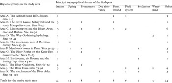
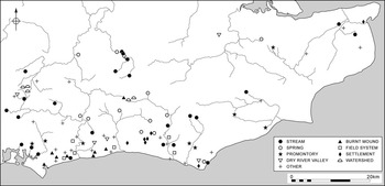
The principal hoard locations in all these study areas are summarized in table 1.
Summary of the main hoard locations in the areas studied in the field. Of the locations classified as ‘other’, there are fourteen with no recognizable characteristics, three marsh sites (66, 83, 94), four hillforts (15, 16, 87, 98), a river find (60) and two findspots perhaps associated with gaps in the chalk (54 and 81)

Conclusions
The original aim of the project was to characterize the findspots of Bronze Age hoards and single finds using a combination of field walking, test pitting and geophysical survey. It soon became apparent that all these methods had limitations. Not only did field walking require large tracts of cultivated land, it was so labour-intensive that it was used on a restricted number of sites. The same applies to the other techniques. At first this appeared to be a disadvantage, but in selecting suitable places to investigate it became apparent that many of them occupied distinctive topographical locations and that they needed to be investigated in detail. In fact it was no accident that so few of the hoard sites were under the plough. It happened because some of them occupy quite marginal positions in the modern landscape. Certain kinds of deposit were appropriate in certain natural settings. The point has been accepted for the weapons found in rivers, but in this study the metalwork consisted mainly of tools and raw material found on dry land. The contents of these deposits can be studied in more detail than has been undertaken here, for it seems possible that the selection of particular items for inclusion in these hoards was influenced by their locations in the prehistoric landscape. There is thus scope for further research.
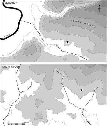
The contexts of the hoards do not seem to have changed significantly between the Middle and Late Bronze Ages, and in both periods it is hard to support the argument that their deposition was a purely ‘practical’ procedure. They exhibit a recurrent association with fresh water and with springs, pools, streams, rivers and confluences. In some instances they were placed on small areas of higher ground overlooking these features (figs 12 and 13). In others they were located near to burnt mounds or coaxial field systems (fig 14). A few finds of ornaments suggest another pattern, for in some cases they were deposited in inland areas. A small number of deposits were also in ‘hidden’ locations on small patches of heavy clay.
The siting of metalwork hoards on promontories at Pett and Wilmington, East Sussex, and their relationship to local watercourses

The siting of metalwork hoards on promontories in relation to the Rivers Arun and Great Stour and their tributaries. Local place names are omitted to protect the findspots

The principal characteristics of the hoard sites investigated in the field

On the West Sussex coastal plain there is evidence to suggest that most of the hoards were near to late prehistoric flint scatters or to excavated settlements and field systems of Middle and Late Bronze Age date. At present it is difficult to compare their chronologies in detail, but that should be possible in the future through carefully targeted research. On the other hand, the evidence from the chalk is rather different. With the doubtful exception of the finds from three fortified hilltops, the main deposits of metalwork were not inside the occupation sites on the downland. Indeed, there are fewer finds of bronze artefacts, even from the extensively excavated settlements on the high ground. These places lacked a dependable water supply, and it may be significant that the distribution of metal finds in south-east England so often follows the courses of permanent or seasonal streams.
Thus only part of the settled area may have been used for the deposition of hoards. Perhaps certain locations were considered appropriate for the burial of bronze artefacts and others were unsuitable. That may be the most significant finding of this project. For some time it has been apparent that concentrations of metalwork hoards occur in the same areas as excavated settlements. This work suggests that the link was not always so direct. It is possible – but unproven – that the distribution of hoards also extended into areas that could not have been farmed. Still more important is the consistent link between the locations of metalwork hoards and details of the local topography. Unlike the weapons associated with the Thames, the hoards were not deposited in the water itself. Instead they were buried in dry ground but often in positions that overlooked springs and watercourses a short distance away. Recent research in the English Fenland suggests an equally complex pattern, for here different kinds of metalwork were deposited in different kinds of water.Footnote 56
It seems likely that these conventions changed from one area to another. For instance, there was growing emphasis on deposits of weapons in the hinterland of the Thames Valley. There are more local contrasts between the siting of hoards containing tools and those with ornaments. The comparatively rare gold hoards in the Weald also come from distinctive locations. It will be necessary to follow this study by conducting fieldwork in other regions, but it is already apparent that finds of Bronze Age metalwork can be investigated in a new way. In particular, it makes it possible to predict where fresh discoveries are most likely to occur.
The possibility has hardly been considered before, but this approach has already been taken in another sphere. For some time it has been obvious that metal detectorists have been extraordinarily fortunate in locating previously unrecorded hoards. The same people have found them on a number of different occasions. Discussions with the finders have made it clear that this did not happen by chance. Long before prehistorians had realized that the siting of hoards might follow topographic ‘rules’, metal detectorists had reached the same conclusion. Their ability to make new finds is the clearest indication of the usefulness of taking a fresh approach to this material. That is why a project that began as a contribution to prehistoric archaeology has unexpected implications for the management of the cultural heritage.
Acknowledgements
The project was funded by the Arts and Humanities Research Council. Fieldwork in West Sussex was carried out in collaboration with David Dunkin. We must also thank the staff of the Portable Antiquities Scheme for their assistance. Liz Andrews-Wilson, Frank Basford, Laura Burnett, Dan Pett, Andrew Richardson, Robert Webley, David Williams and Sally Worrell provided invaluable help and advice. We must also acknowledge the help of Dave Thornley (geophysics), Bridget Neeve and members of the Brighton and Hove Archaeological Society. The results of developer-funded fieldwork were kindly made available by Alistair Barclay, Kathy Grant, Diccon Hart, Greg Priestley-Bell, Jörn Schuister, Jim Stevenson, Jon Sygrave and Andy Taylor. Greg Chuter, John Mills, Rachel Salter, Ian Scrivener-Lindsay, Mark Taylor and Keith Watson helped to search the public records, and local archaeologists Ron Bowman, Gill Davies and Tyndall Jones shared their knowledge of the findspots. Elise Fraser created and managed the database and Aaron Watson is responsible for the illustration in this paper. Finally, we are grateful to all the landowners who allowed access to the sites, in particular Cathy Foreman and Mr P Hicks for their enthusiastic support.