

The Meath–north Dublin region of eastern Ireland, corresponding with the ancient territory of Brega (Bhreathnach Reference Bhreathnach2005a), is home to some of the most celebrated archaeological sites on the island. Alongside the Hill of Tara, in central Meath, and the famed passage tomb complexes at Brú na Bóinne (the Boyne Valley), Loughcrew, and Fourknocks, the archaeological evidence from places like Teltown (ancient Tailtiu), Tlachtga (the Hill of Ward), Lagore, Raffin Fort, and Lambay, among others, serves to further illuminate the rich and deep history of this region. Renowned for its fertile soils and navigable rivers such as the Boyne and Blackwater, the region is also favoured by an accessible coastline, making it from the earliest times an important conduit for the movement of people, goods, and ideas between Ireland, Britain, and the continent (Waddell 1991/Reference Waddell2; Charles-Edwards Reference Charles-Edwards1999; Cunliffe Reference Cunliffe2001; Newman Reference Newman2005; Bhreathnach Reference Bhreathnach2005a, 410–12; Reference Bhreathnach2011, 130–2). Perhaps the clearest illustration of the ‘internationalisation’ of this area in prehistory is provided by the artefact and burial records of the Iron Age, not least the occurrence here of the greatest concentration of Roman material in Ireland (eg Bateson Reference Bateson1973; Raftery Reference Raftery1994; Newman Reference Newman1998; Reference Newman2005, 366 and 381–2; O’Brien Reference O’Brien2003; Cahill Wilson et al. Reference Cahill Wilson, Standish and O’Brien2014a).
Although Tara’s renown as the pre-eminent ‘royal’ site of ancient Ireland and seat of the high-kings rests largely on a reputation forged in the medieval period (eg Bhreathnach Reference Bhreathnach1996; Reference Bhreathnach2005b; Reference Bhreathnach2014), the exceptional nature and scale of some of the monuments within the extensive ceremonial and funerary complex on the hill, and in its wider landscape, seems to support the view that Tara was the dominant focal centre in the region from at least later prehistory (Newman Reference Newman1997; Reference Newman2005, 378–9; Reference Newman2011). Chronologically, the monuments on the Hill of Tara appear to span from about the mid-4th millennium bc to the second half of the 1st millennium ad (Newman Reference Newman1997; Reference Newman2007), however only three have been subject to archaeological excavation: the Mound of the Hostages (Duma na nGiall), a Neolithic passage tomb reused for burial during the Early Bronze Age (O’Sullivan Reference O’Sullivan2005); Ráith na Ríg (‘Fort of the Kings’), a 320 m diameter internally-ditched enclosure dated to the 1st century bc (Roche Reference Roche2002); and the Rath of the Synods (Ráith na Senad), a 2nd–4th century ad multivallate enclosure which represents the latest structural phase at this multi-period site and is associated with one of the largest assemblages of provincial Roman material in Ireland (Grogan Reference Grogan2008). Though a relative chronology has also been established for some of the other enclosures and burial monuments on the hill (Newman Reference Newman1997; Reference Newman2007; Fenwick & Newman Reference Fenwick and Newman2002), the vast majority of monuments at Tara remain undated, leaving major gaps in our understanding of the development of the complex as a whole. Indeed, while by the 7th century ad Tara had emerged as the pre-eminent focal centre in Brega – and, moreover, as a ‘royal’ site of supra-regional significance – precisely when it achieved this status has yet to be established. Although further archaeological work at Tara is clearly essential to addressing this question, any consideration of its evolving role and importance over time must also take account of other, potentially contemporary, focal centres and broader developments in the region.
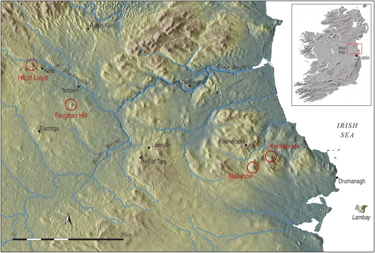
The present study arises out of the Discovery Programme’s ‘Late Iron Age and ‘Roman’ Ireland’ (LIARI) Project and earlier ‘Tara Project’,Footnote 1 and was designed to contribute to this research by investigating a number of hilltop sites suspected on the basis of archaeological, topographical, and early documentary evidence to have been important focal centres in later prehistory. The investigations combined extensive geophysical survey with broader landscape analysis, drawing on LiDAR data, aerial imagery, and early documentary sources, and targeted four sites in two separate study areas (Fig. 1): Knockbrack and Mallahow, near the village of Naul, in north Co. Dublin, the former crowned by prehistoric burial mounds and a massive enclosure; the Hill of Lloyd, in west-central Meath, the site of a prehistoric enclosure overlooking the early monastic foundation at Kells; and nearby Faughan Hill, the reputed burial place of Niall of the Nine Hostages (Niall Noígiallach), eponymous ancestor of the Uí Néill federation of dynasties that came to dominate the kingship of Tara from the 7th to early 11th centuries (eg Bhreathnach Reference Bhreathnach2005b). Despite the obvious archaeological potential of these sites, however, none had been subject to detailed investigation prior to the present study.
Map of the Meath–Dublin region showing the location of target sites (circled in red) and other signification places in the area

Geophysical Survey
The geophysical surveys, comprising magnetic gradiometry, were conducted on a phased basis between August 2013 and September 2014 and covered a total area of approximately 24 ha. The investigations were focused on the summits of the four target hills which, geologically, comprise sandstone and (at Faughan) limestone, overlain mainly by limestone and shale till. The survey areas were aligned to Irish National Grid using a Trimble 5800 series GPS in conjunction with the VRSnow correction service. Two Bartington Grad 601-2 fluxgate gradiometers were employed for the surveys. Data were collected at 0.25 m intervals, moving from south to north along traverses set 1 m apart, though more detailed survey (0.25×0.5 m) was also undertaken on the summit of the Hill of Lloyd to provide greater resolution of archaeological features. The geophysical data presented as greyscale images below have been interpolated (from 1 m to 0.5 m/0.5 m to 0.25 m in traverse spacing) to improve visual quality, but have otherwise undergone minimal processing.
While features of archaeological significance predominate, some of the anomalies recorded by survey relate to modern land-use practices. Apart from Knockbrack, which is still used for tillage, all of the sites are currently under pasture but have been cultivated in the past, with the effects of ploughing and, to a lesser extent, adjacent wire fencing evident in most areas. The numerous small ferrous responses registered by the survey relate to metallic material in the topsoil which is likely, for the most part, to represent modern iron litter but may also encompass objects of archaeological interest. Landscaping in recent centuries at the Hill of Lloyd and Faughan has also produced some distinctive anomalies, discussed below, whose imprint has in certain instances obscured the signature of weak archaeological features. Despite this, however, the surveys have provided major new insights into all of the sites investigated, revealing important information on the layout and character of several previously ill-defined hilltop enclosures, as well as identifying an astounding array of new archaeological monuments and features.Footnote 2
Knockbrack & Mallahow, North Co. Dublin
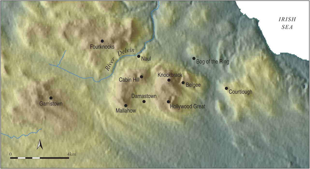
At 176 m above sea-level (ASL), Knockbrack (an Chnoic Bhric, ‘the speckled hill’)Footnote 3 is the highest of a belt of hills that extends westwards from the coast at Loughshinny, north Co. Dublin, as far as Tara (Figs 2 & 3). All of these hills, which include several low but conspicuous rises at Popeshall (57 m ASL), Baldongen (69 m ASL), and Courtlough (94 m ASL), as well as the more prominent eminences of Mallahow (148 m ASL), Fourknocks (158 m ASL), Garristown (168 m ASL), and Skreen (172 m ASL), are crowned by significant archaeological monuments (Hartnett Reference Hartnett1957; Reference Hartnett1971; Newman Reference Newman2005; Kilbride-Jones & Monks Reference Kilbride-Jones and Monks2011), some of which have only recently come to light through geophysical survey undertaken by the LIARI Project (Dowling Reference Dowling2014a; see below). Separating Knockbrack and the neighbouring hills of Cabinhill (143 m ASL) and Mallahow from the renowned early prehistoric cemetery at Fourknocks, only 5 km to the north-west, is the broad valley of the River Delvin, which today forms part of the county boundary between Dublin and Meath. The estuaries of the Delvin (Inber nAilbine) and Broad Meadow rivers, at Malahide Bay (Inber nDomnann), lie 7 km north-east and 15 km south-east of Knockbrack respectively, placing the hill, and nearby Mallahow, in close proximity to two of the key landing places on the east coast referred to in early Irish documentary sources (see Bhreathnach Reference Bhreathnach2005a, 411).
Map of the Knockbrack–Mallahow region

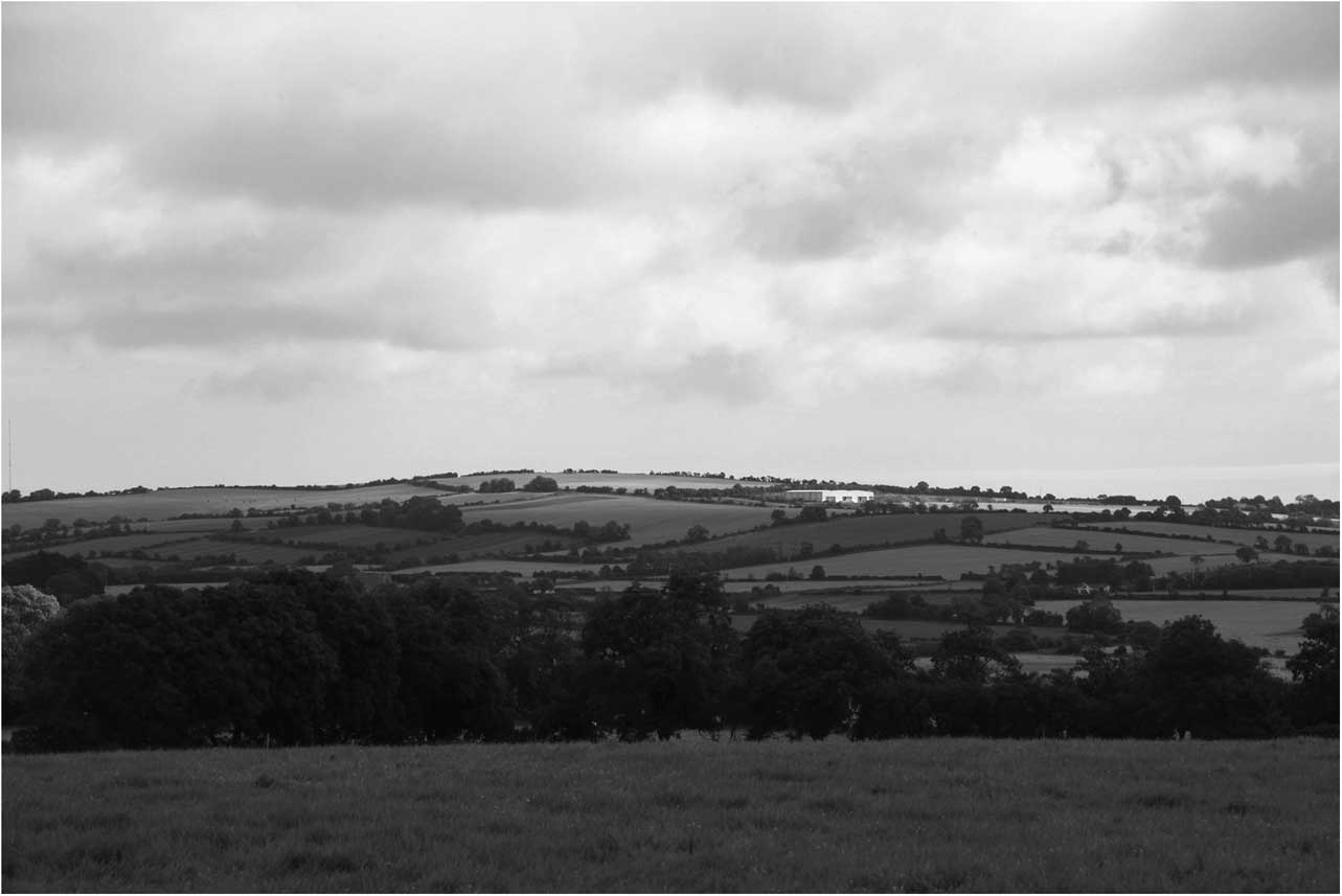
Looking north-eastwards from Mallahow towards Knockbrack

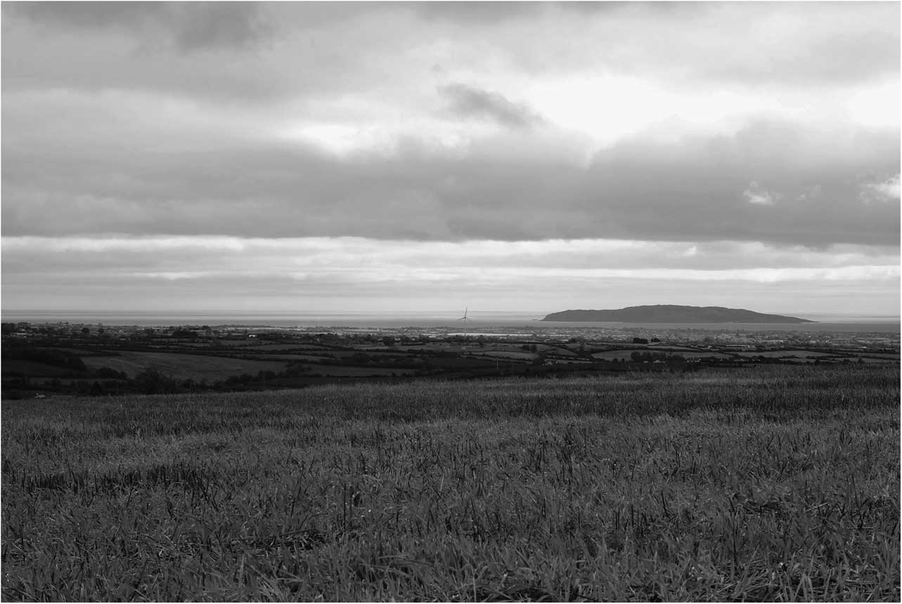
The strategic position of Knockbrack is further enhanced by the extensive panoramic views afforded from its summit. On a clear day the entire central-eastern seaboard, sweeping southwards from the Mournes to the Wicklow Mountains, opens up, with Slieve Donard, the Boyne estuary, Howth Head, and many other significant landmarks clearly discernible. Impressive vistas are also provided westwards over the rolling drumlin topography of Meath and across the plain of the River Liffey to the south. This commanding aspect, overlooking sea and coast, riverine networks, and gateway sites, draws the hill into the littoral landscape of eastern Ireland, a zone of interaction where cultural connections between communities living either side of the Irish Sea were forged and sustained over many millennia (Waddell 1991/Reference Waddell2; Charles-Edwards Reference Charles-Edwards1999; Cunliffe Reference Cunliffe2001; Newman Reference Newman1998; Reference Newman2005, 366; Bhreathnach Reference Bhreathnach2005a, 410–12; Reference Bhreathnach2011, 130–2). Dominating the eastern horizon is Lambay Island (Fig. 4), whose strategic location in respect of maritime trade and exchange routes along this part of the coast, and within the wider Irish Sea province, is illustrated from as early as the Neolithic (Cooney Reference Cooney2004; Cahill Wilson et al. Reference Cahill Wilson, Cooney, Dowling and Elliott2014b). Also within view, 12 km to the east of Knockbrack, is the coastal promontory fort at Drumanagh, a site long suspected to have been an important entrepôt linking eastern Ireland with Roman Britain (eg Raftery Reference Raftery1994, 207–8; Mitchell & Ryan Reference Mitchell and Ryan2003, 246–7; see also Dowling Reference Dowling2014a). The discovery at Damastown, 2 km from Knockbrack and Mallahow, of a Roman-type copper ingot identical to those identified at Drumanagh (Raftery Reference Raftery1994, 208; Mitchell & Ryan Reference Mitchell and Ryan2003, 247), suggests that individuals or communities in the Knockbrack area in the early centuries ad may have been tied into a wider network of trade or exchange facilitated by gateway sites on the eastern seaboard. Indeed, as well as navigable rivers like the Boyne, one of the more important overland routes in this region may, as Newman (Reference Newman2005, 379) has proposed, have served to connect Drumanagh and Tara, passing by Knockbrack and Mallahow.
View of Lambay Island from the summit of Knockbrack

Knockbrack
The hill of Knockbrack descends gently to the south to meet the adjacent rise of Hollywood Great (151 m ASL), producing a distinctive ‘saddle-shaped’ profile common to many of the ridges in this region. The domed summit of Knockbrack gives way on the north to a broad level plateau, beyond which the land falls away steeply, as it does to the west. The hill slopes more gently to the east, where a narrow valley known as ‘Knockbrack Glen’ separates it from a low rise in Belgee townland, which overlooks the now much-reduced ‘Ring of the Bog’, the only freshwater marsh in Dublin (Goodwillie & Fahy Reference Goodwillie and Fahy1973, 61–3).
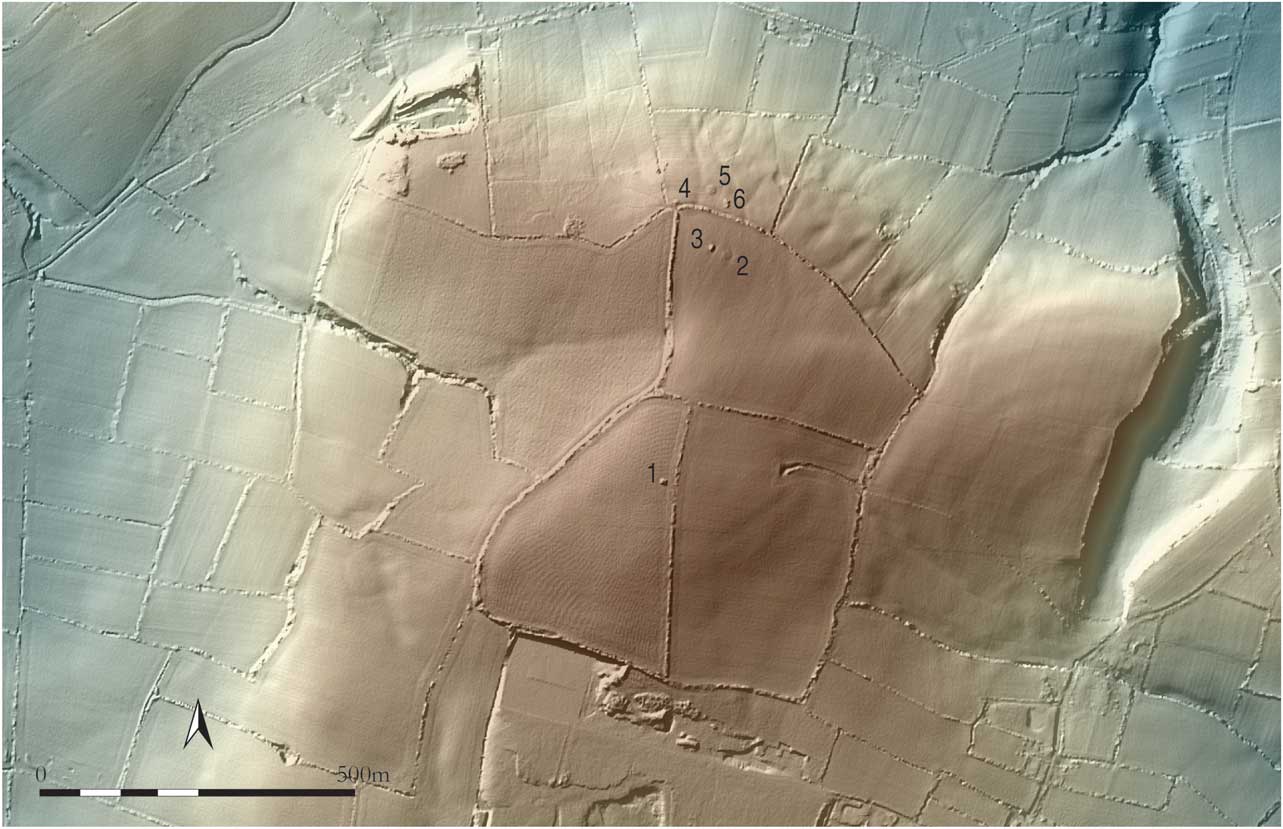
Like several other hills in its vicinity, Knockbrack is the location of a significant concentration of archaeological remains. Some of these survive as surface features while many others were revealed through the present geophysical investigations, which covered most of the summit and upper slopes of the hill (total area c. 11.2 ha). The visible monuments consist of six, roughly circular, earthen mounds and traces of a large hilltop enclosure first identified as a cropmark on aerial imagery in 1982 (Fig. 5; Keeling Reference Keeling1983, figs 22 & 24). One of the mounds (measuring c. 10 m in diameter and 1.5 m in height) is situated near the summit, while the others, which vary from about 8 m to 13 m in diameter, are located to the north: two set close together on the plateau extending from the summit and the remainder strung along the 150 m contour, immediately below the cusp of the hill. Yet another mound, of similar size, crowns the summit of the adjacent rise at Hollywood Great, less than 2 km to the south. The northerly distribution of all but one of the mounds at Knockbrack, however, suggests an orientation towards the coast and the lowlands around the River Delvin, while the siting of the summit mound just to the south-west of the highest point of the hill affords it a wider perspective, extending south-eastwards from Fourknocks to encompass the lands around Mallahow and Damastown. Although a late prehistoric date for these putative burial monuments has previously been advanced by Keeling (ibid., 70), the broad chronology of comparable, excavated mounds in Ireland (eg Hencken & Movius Reference Hencken and Movius1934; Raftery 1960/Reference Raftery1961; O’Sullivan Reference O’Sullivan2005), and the site’s close proximity to Fourknocks, also leaves open the possibility of an earlier, Neolithic or Early Bronze Age, date.
LiDAR map of Knockbrack showing the location of mounds (Nos 1–6); the summit mound (1) lies at the approximate centre of the hilltop enclosure (LiDAR data courtesy of Fingal County Council)

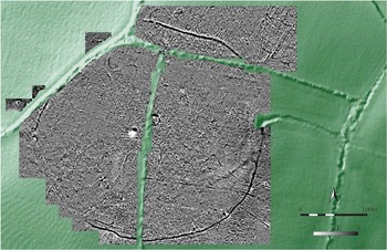
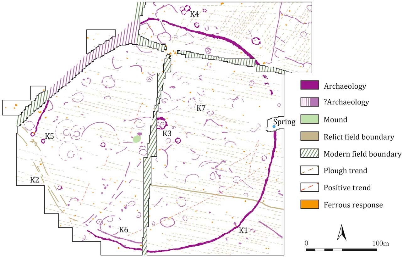
The summit mound is the only visible monument within the hilltop enclosure, the significance of which was corroborated by geophysical survey (Figs 6 & 7). Although largely levelled today, the enclosure appears in its original form to have been defined by a broad, roughly circular ditch with external earthen bank, a small segment of which survives on the north-west, where it has been incorporated into a modern field boundary (Keeling Reference Keeling1983, 71). Positioned on the break of slope, the extant bank measures c. 4 m in width and stands approximately 1.5 m above the exterior ground surface and 0.5 m above the present base of the ditch (c. 6 m in maximum width). Though no traces of a bank were identified elsewhere by the survey, the enclosure ditch is generally well defined geophysically. It registers as a positive magnetic band varying from 2 m to 5 m in width (K1), except on the east-north-east, where its line is all but invisible in the survey, and on the south-west, where it is substituted by up to three discontinuous, arcuate negative lineations (K2). The latter anomalies, which continue beyond the enclosure to meet the western field boundary, mark the line of a former field division shown on the 1st (1837) and 2nd edition (c. 1900) Ordnance Survey maps, and suggest that this part of the enclosure also retained a surface presence until relatively recently. While these variations and discontinuities in the geophysical signature of the enclosure boundary make it difficult to establish the location of an original entrance(s), such a feature may be indicated by a 4 m wide gap, flanked by slightly swollen ditch terminals, on the north.
Knockbrack: greyscale image of gradiometry results overlaid on a LiDAR map (LiDAR data courtesy of Fingal County Council)

Knockbrack: interpretative plan showing principal geophysical anomalies

Encompassing an area of approximately 8.5 ha, with maximum dimensions of 350 m east–west by 330 m north–south, the enclosure is truly monumental in scale, surpassing in size the 1st century bc internally-ditched enclosures of Ráith na Ríg at Tara, and Navan Fort, Co. Armagh – sites with which it is closely comparable (cf. Keeling Reference Keeling1983, 74; Raftery Reference Raftery1994, 80). Interestingly, the line of the enclosure flattens out on the north, possibly to avoid a cluster of potential ring-ditches in this area (see below), recalling a phenomenon also seen, for example, in the layout of Ráith na Ríg (Newman Reference Newman1997) and the ditch encircling the base of the great mound at Rathcroghan, Co. Roscommon (Waddell et al. Reference Waddell, Fenwick and Barton2009). A curious indent also occurs on the south side of the enclosure and may likewise reflect the presence here of a significant feature/s, though no clearly-defined footprint of such is apparent in the geophysical data. In contrast, a natural spring emanating from a conspicuous arc-shaped (natural?) depression that extends from the eastern side of the enclosure appears to have been deliberately subsumed within the enclosure boundary, perhaps indicating a symbolic or ritual significance for the spring.
A plethora of previously unknown archaeological features was also identified by the survey inside and surrounding the hilltop enclosure. The magnetic intensity of these features varies considerably, however, with many exhibiting signatures that are barely discernible above the magnetic background response. This is probably due to the disturbance or truncation of archaeological deposits by modern ploughing (evidenced in the survey as two contrasting patterns of closely-set linear trends), which may also account for the variability in the background responses noted across the site.
Small circular anomalies or ring-ditches are among the most numerous features recorded, with over a dozen possible examples identified inside and to the north of the hilltop enclosure. The majority measure between 5 m and 12 m in diameter, and where potential entrances gaps can be identified, they tend to face north-east. Some of the ring-ditches display strong magnetic responses (10–20nT), suggesting the presence of burnt material in their fills, and several have small anomalies, possibly pits, in their interiors. The largest and most striking example (K3) occupies the highest point of the hill, at the approximate centre of the enclosure, and is characterised by a broad, positive magnetic annulus, c. 18 m in diameter, the western sector of which is obscured by a modern field bank. Several pit-type anomalies and zones of increased magnetic response in its interior are likely to denote archaeological features and deposits. The elevated siting of this ring-ditch, overlooking the extant mound just to its south-west, is significant and raises the possibility that it once encircled a now-destroyed mound or barrow which acted as a focal point for some of the other monuments on the hill. Moreover, like several smaller ring-ditches on the northern plateau, the central position of this putative burial monument within the hilltop enclosure suggests that it, too, may pre-date the enclosure and had a bearing on its ground plan. Some of the ring-ditches form small clusters and several examples visibly overlap (K4), providing a further illustration of multi-phase activity.
The remaining features identified by survey are disparate and often poorly-defined but, nonetheless, highlight the intensity and varied complexion of past activity on the hilltop. A significant number of faint, circular, oval, and arcuate features is apparent on close examination of the data which may represent the remains of enclosures and structures of varying size and form. Some of the larger examples (eg K5 & K6) have diameters in the region of 25–30 m and appear to enclose small circular features and/or pits. An oval-shaped setting of possible post-pits (K7) located c. 40 m north-east of the summit ring-ditch is also of interest and may describe a small enclosure with dimensions of approximately 15 m north–south by 10 m east–west. Small pit-type anomalies also occur elsewhere across the site, though few form coherent patterns and it is possible that some have an agricultural or natural (geological/pedological) origin. In addition to several relict field boundaries marked on early Ordnance Survey maps, many of the other linear features mapped by the survey may likewise relate to agricultural activity, however in the absence of any supporting evidence their significance and antiquity is uncertain.
Mallahow
Unlike Knockbrack, no archaeological features were recorded on the summit of nearby Mallahow (or Mullahow, Mullach Uamha, ‘hill of the cave/souterrain’) prior to the present survey. However, the presence on the southern flank of the hill of a prominent, ditch encircled, mound, possibly an Anglo-Norman motte (Healy Reference Healy1975), and its proximity to the find-spot of the Damastown ingot, suggest an earlier importance for the site, as does its putative location on an ancient routeway. The hill is one of two prospective sites (along with Navan, Co. Meath) identified by historians as ancient Odba (Mullach Odhbha, ‘Odhbha’s Hill’), the reputed burial place of the eponymous first wife of the legendary king of Ireland, Éremón (Morris Reference Morris1939, 186–9; see also Bhreathnach Reference Bhreathnach2005a, 417–18).
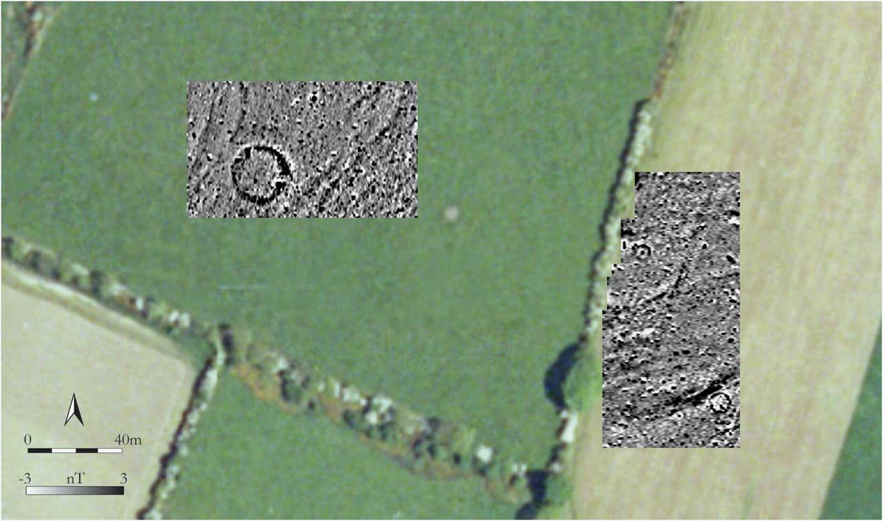
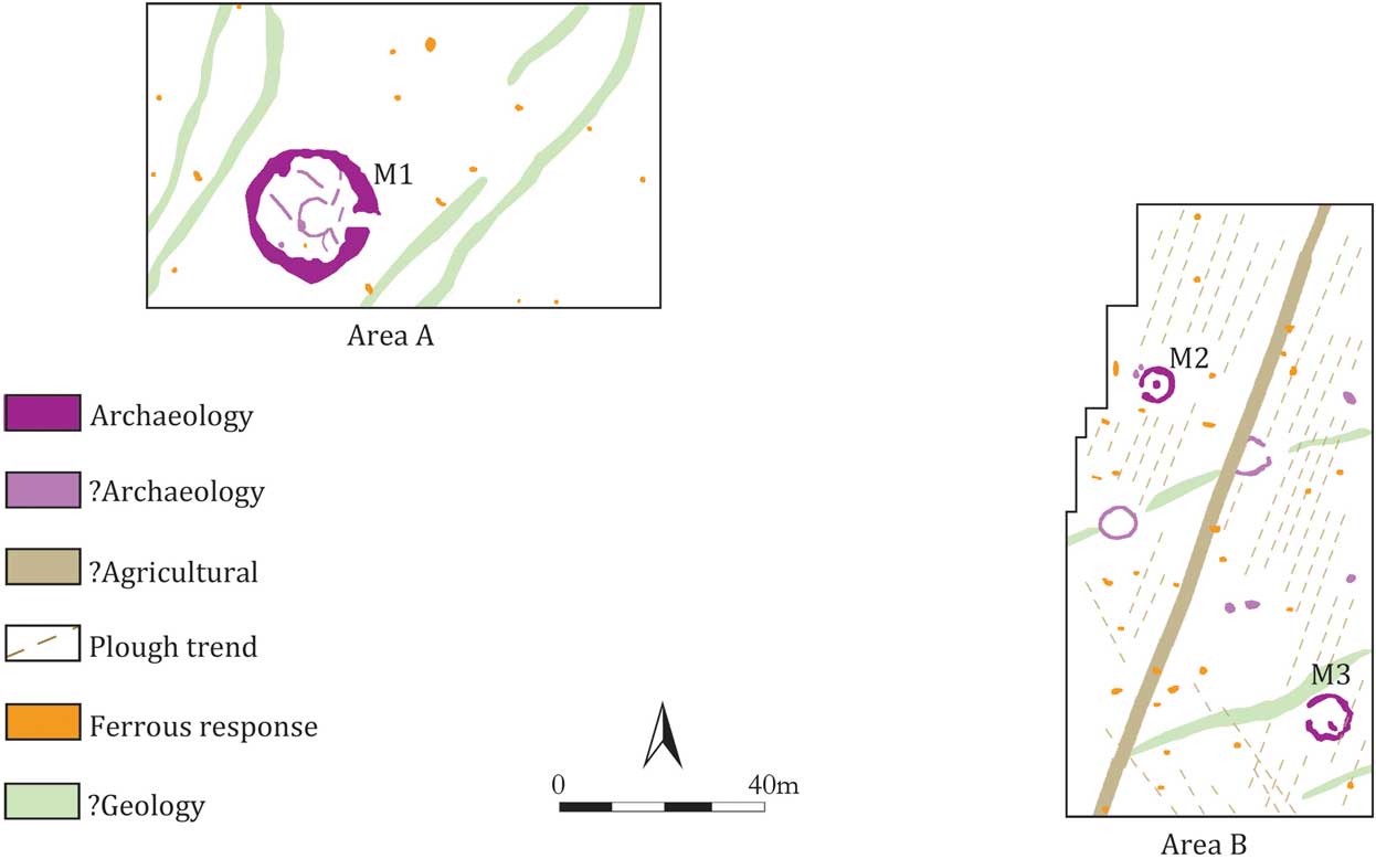
Geophysical survey at Mallahow has confirmed that the hill was indeed a focus for ancient activity (Figs 8 & 9). The survey covered two small areas of pasture separated by a tree-lined field bank, the first of which (Area A) encompassed the highest point of the hill, while the second (Area B) lay 80 m downslope to the east. Despite the modest size of the areas investigated (c. 1.3 ha in total), no less than five circular features, including a well-defined enclosure, were identified, all of which exhibit positive ditch-type responses. Although time constraints prevented more extensive survey, the results of the present work clearly justify further investigations at the site in the future.
Mallahow: greyscale image of gradiometry results overlaid on an aerial orthophoto image (Orthophoto © Ordnance Survey of Ireland. All rights reserved. Licence no. EN0059212)

Mallahow: interpretative plan showing principal geophysical anomalies

Crowning the gently rounded summit of the hill, the enclosure (M1) displays a particularly striking signature and appears to be defined by a circular ditch measuring some 3–4 m in width and 25 m in maximum diameter, with a causeway entrance on the east. Faint traces of features are evident inside the enclosure, including the possible outline of a centrally-positioned, circular building, as well as several short lineations which could potentially reflect sub-divisions of the interior space. There are no indications of an earthen bank accompanying the ditch; however the former presence of an inner bank, if such existed, would have reduced the internal area to no more than c. 15 m. This is well below the average for an early medieval ringfort and thus opens up a wide range of possibilities as regards the dating and role of the enclosure.
The remaining circular features lay downslope from the enclosure, to the south-east, and are of more modest dimensions, varying from c. 5 m to 8 m in overall diameter. The two most clearly defined examples (M2 & M3) are described by positive penannular rings, open to the west, and each has a single pit-type feature in its interior. Located between them are at least two other potential circular features defined by less coherent responses. While, individually, the size and form of these features is not inconsistent with slot-trenches for circular buildings or round-houses, as a group they are perhaps more suggestive of ring-ditches.
The Hill of Lloyd & Faughan Hill, Co. Meath
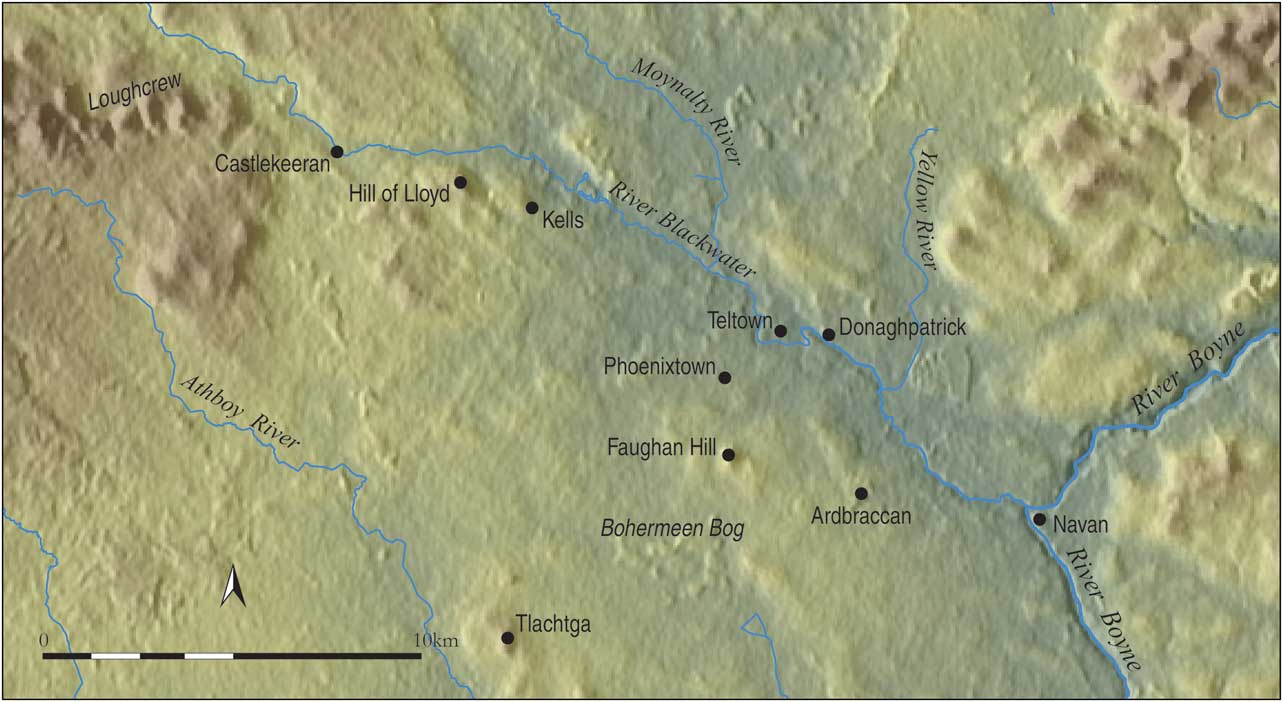
The Hill of Lloyd (129 m ASL) and Faughan Hill (109 m ASL) are two of the most conspicuous landmarks to punctuate the fertile lowlands to the west and north-west of Tara (Fig. 10). Generally lying between 40 m and 80 m above sea-level and traversed by a dense network of rivers and streams, these lowlands are bounded to the west by a sinuous belt of hills and drumlins that define the modern border between counties Meath, Westmeath, and Cavan. Passing directly to the north of the Hill of Lloyd and Faughan, the River Blackwater flows in a south-easterly direction from Lough Ramor in Co. Cavan to its confluence with the River Boyne at Navan, while further to the south, the Athboy River runs in a similar direction to join the Boyne near Trim. Both hills stand in close proximity to key fording points on the Blackwater, an important conduit for riverine and overland movement in antiquity (see below). The surrounding locale is home to an impressive array of prehistoric and later archaeological sites, among the most eminent of which are the multi-period complexes of Teltown (Swan Reference Swan1998; Eogan Reference Eogan2006), the site of the famed Lugnasad assembly (Óenach Tailten) presided over by the early medieval kings of Tara (Binchy Reference Binchy1958; Swift Reference Swift2000; Bhreathnach Reference Bhreathnach2011), and Tlachtga. Lying directly to the north of the rivers Blackwater and Athboy, respectively, Teltown and Tlachtga have been suggested by Newman (Reference Newman2005, 367–70, 400–3) to represent the principal focal points of two discrete landscapes, the boundary between which is defined topographically by Bohermeen Bog, 2 km south of Faughan Hill.
Map of west-central Meath showing the location of the Hill of Lloyd and Faughan Hill, as well as other sites mentioned in the text

The Hill of Lloyd
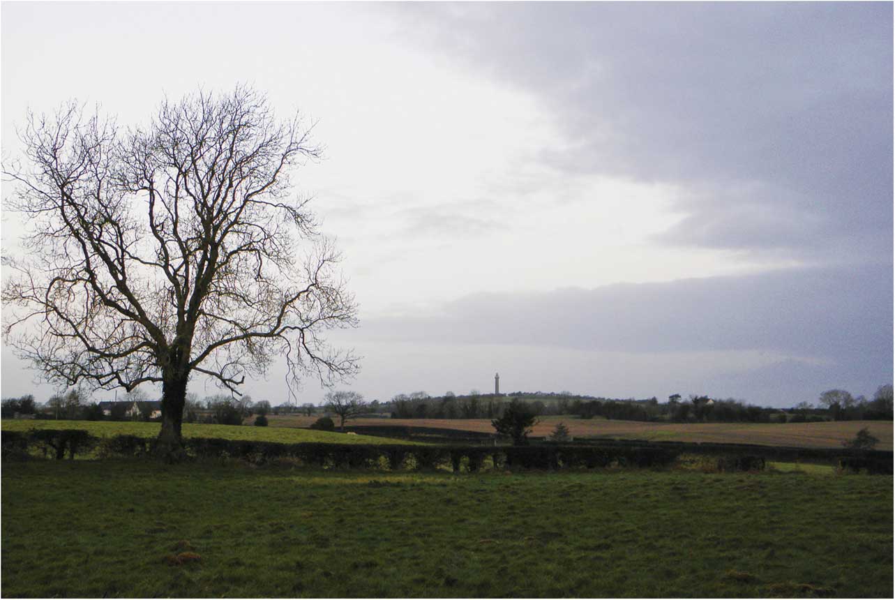
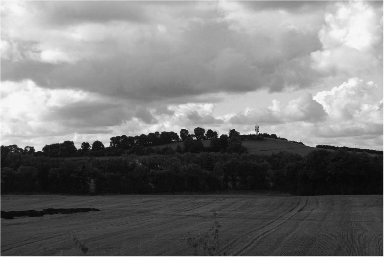
Dominating the western approach to the Blackwater Valley and the Hill of Tara beyond, the Hill of Lloyd (Mullach Aite, ‘Aite’s Hill’) occupies a key strategic position and is easily recognisable from afar, being distinguished all the more today by the tall inland lighthouse, known as the ‘Spire of Lloyd’, erected as a folly on its summit in 1791 (Fig. 11; Carr Reference Carr2000). The hill, which overlooks the early monastic foundation at Kells 1.5 km to the east, affords a particularly commanding prospect over the surrounding lowlands, with many of the distant hills that frame the region clearly visible from its gently rounded summit. Looking clockwise from the cairn-topped hills near Ballieborough, Co. Cavan, to the north, the view encompasses such elevations as Slieve Breagh and Mount Oriel, to the north-east, Slane, Faughan Hill, Tara, and Skryne, to the east and south-east, and Tlachtga, to the south, all significant sites in their own right. Some 12 km to the west of Lloyd, and foreshortening the view in that direction, the distinctive three-peaked ridge at Carnbane West, Carnbane East, and Patrickstown, provides a suitably impressive setting for the renowned passage tomb cemetery of Loughcrew (Sliabh na Caillighe, ‘the Hill of the Witch’). Further to the north-west the vista opens once again to afford uninterrupted views over the upper reaches of the Blackwater Valley and the hills that flank it to either side, at Bruse and Kingsmountain.
The Hill of Lloyd, viewed from the south-east

An historical importance for the Hill of Lloyd–Kells area is documented even prior to the establishment of the Columban monastery at the foot of the hill in the early 9th century ad. Lying at the western extremity of the territory of Fir Chúl Breg (‘men of the nook/corner of Brega’), Kells is recorded as the site of a battle in 718, reflecting a wider pattern of military engagements focused on strategic boundary locations in early Ireland (Ó Riain Reference Ó Riain1974; Bhreathnach Reference Bhreathnach2014, 62). An ogham stone at Castlekeeran, less than 4 km west of Lloyd at a point where the Blackwater Valley broadens out, may mark another early territorial boundary, in this case between the Luigne and the Gailenga Mór, to the north (Charles-Edwards Reference Charles-Edwards2000, 467, n82). Kells itself, Old Irish Cenannas (‘the Head Fort’), is traditionally identified as the site of a royal stronghold where the legendary and proto-historical kings of Tara are said to have resided prior to assuming the kingship (Bhreathnach Reference Bhreathnach1995, 94, 99, and 102; Ní Bhrolcháin Reference Ní Bhrolcháin2011, 50). However, while these allusions to an early fort are of interest, apart from a c. 22 m diameter enclosure of possible 7th century date excavated in the 1980s (Byrne Reference Byrne1987; Reference Byrne1988), no substantial structures pre-dating the monastery have yet been identified at Kells. One cannot but wonder, moreover, whether the putative, presumably prehistoric, ‘fort’ in question was located not at Kells, but rather on the far more commanding Hill of Lloyd.
An ancient origin may also be indicated for some of the routeways reputed in early medieval sources to have converged at Kells. The Slige Assail (‘Assal Road’), one of the main east–west arteries in early Ireland (see, eg, Ó Lochlainn Reference Ó Lochlainn1940), would have passed close to the Hill of Lloyd on its route westwards from Teltown and Kells, the probable location of a fording point on the Blackwater. The distribution of prehistoric monuments and later ringforts in this area suggests that the main east–west axis of movement was across the elevated ground and well-drained lands to either side of the river, around the Hill of Lloyd. In addition to the large and obviously important enclosure(s) encircling its summit (described below), the concentration of prehistoric burial monuments in the immediate vicinity of the hill, which includes a number of prominent mounds, three Early Bronze Age cist graves and an Iron Age ring-ditch (Moore Reference Moore1987, 28–9; Healy Reference Healy1891, 595; Whitty Reference Whitty2012), may also be significant in this context. In comparison, the numerous burnt mounds (fulachta fiadh) of predominately Bronze Age date identified to the south of Lloyd during the construction of the M3 motorway (eg Reilly & Ginn Reference Reilly and Ginn2008; Russell & Ginn Reference Russell and Ginn2008; Kyle Reference Kyle2010) indicate that, prior to modern drainage, these lands are likely to have been of more marginal significance from a settlement perspective.
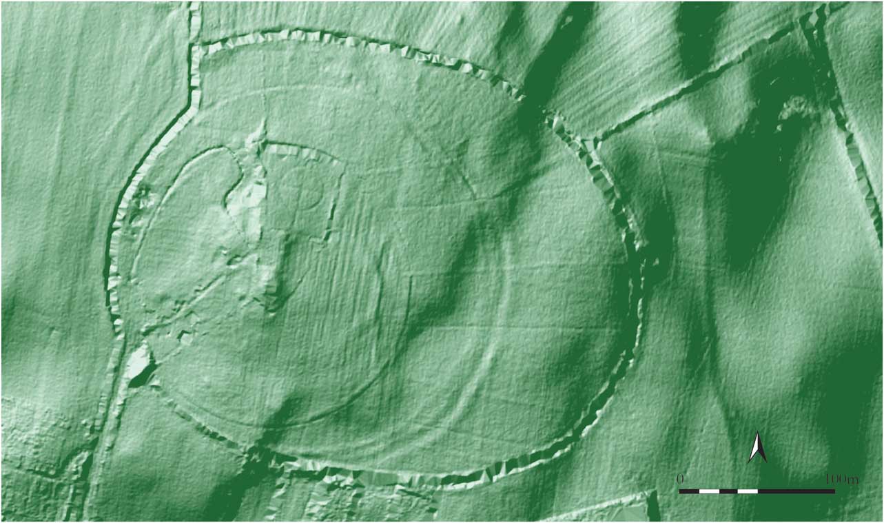
Though the monuments in the immediate vicinity of the Hill of Lloyd point to activity extending back as early as the Bronze Age, the prehistoric importance claimed for the hill has to date rested mainly on its identification as the site of a large contour hillfort. Variously described as comprising three widely-spaced, single ramparts and/or ditches (Moore Reference Moore1996; Newman Reference Newman1997, 201; see also Moore Reference Moore1987, 98), the surviving remains are ephemeral and interpretation of the enclosing elements is complicated further by the extensive overprint of later features on the hilltop. Among the most conspicuous today are two narrow, perfectly circular, concentric ditches that enclose the summit (Fig. 12) and appear on the basis of cartographic evidence to represent landscape features of late 18th or 19th century date. These are surrounded in turn by a curving, tree-lined earthen bank which, together with the inner ‘ditch circle’, demarcated a woodland plantation shown on the Ordnance Survey map of c. 1880. Though the roughly oval ground-plan of the tree-lined field bank may raise suspicion of an archaeological origin, the fact that it cuts across the outer hilltop enclosure (see below) and is not recorded on earlier mapping suggest it to be relatively modern. Much of the area inside the inner circle is taken up by the lighthouse folly and an adjacent workhouse graveyard of mid-19th century date, while the western part of the summit was developed as a public park and recreation area in the early 1990s. These landscape features restricted the area available for geophysical survey, which covered lands totalling 4.9 ha.
LiDAR map of the Hill of Lloyd (LiDAR data courtesy of Kells Heritage Park Ltd)

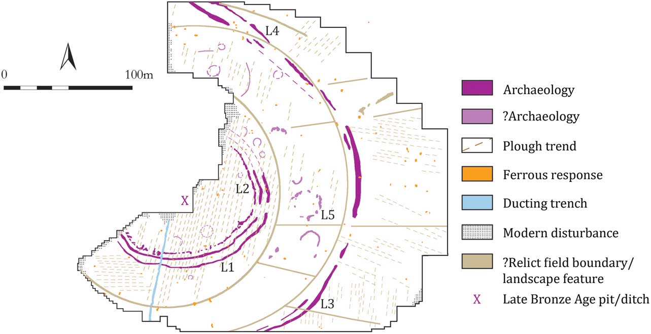
Previous archaeological works at the site involved the excavation of a ducting trench near the folly, which revealed a pit or ditch-type feature containing burnt animal bone (mainly pig) dated to c. 1000 bc (Neary Reference Neary2003). This feature offers an interesting glimpse into activity on the hilltop during the Late Bronze Age; however its significance in terms of the wider context of the site is uncertain. Indeed, as we shall see, the present investigations have revealed that the extant archaeological remains are considerably more complex than is suggested by the site’s classification as a ‘conventional’ (ie, Late Bronze Age) hillfort.
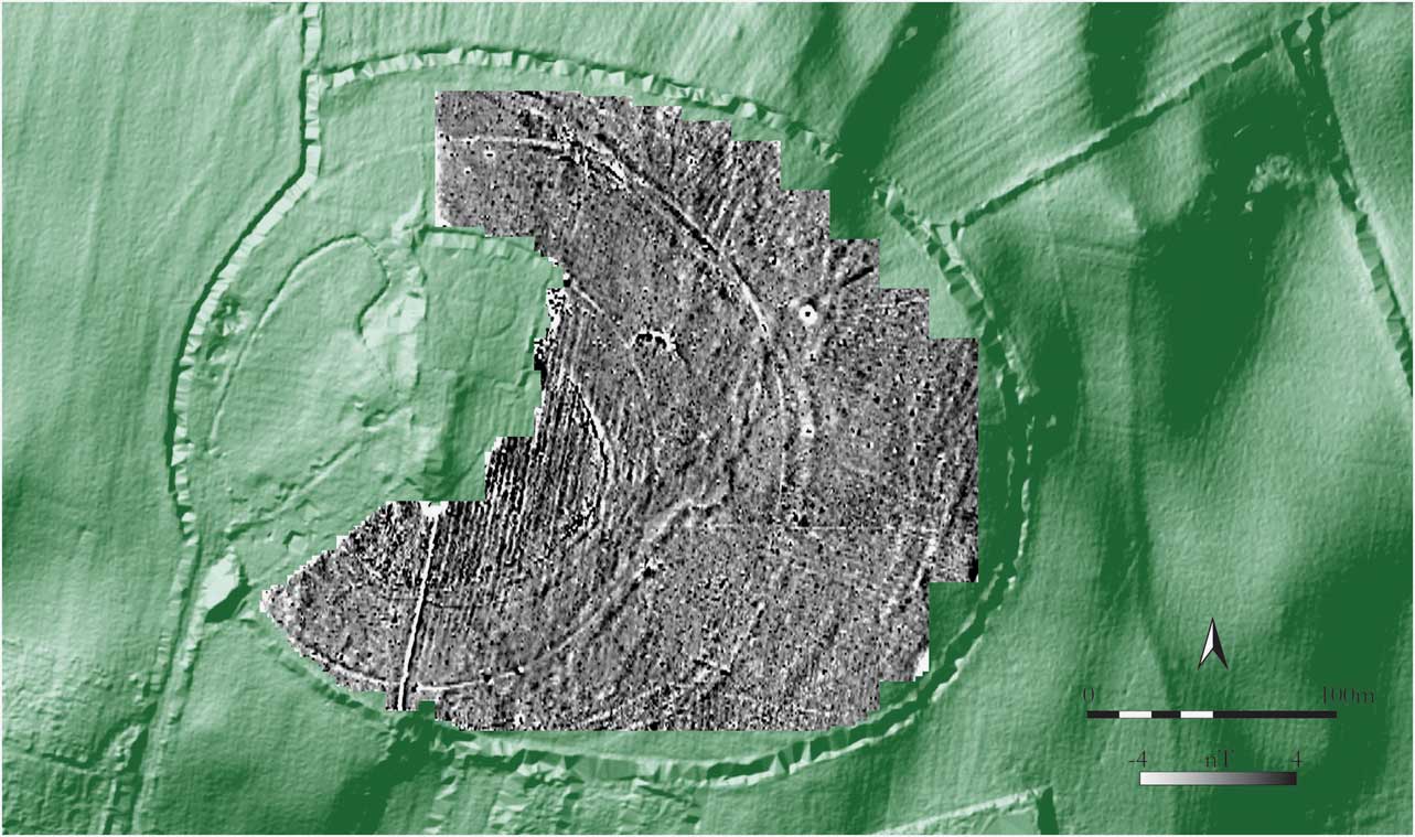
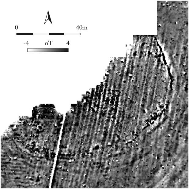
The principal features of interest survive as a series of low-relief, curvilinear banks and ditches that follow the upper contours of the hill on the east and south. Although difficult to discern on the ground, LiDAR survey (commissioned by Kells Heritage Park Ltd) and the 2013 geophysical investigations suggest that they comprise the remains of two widely-spaced, concentric enclosures of roughly circular ground plan (Figs 13 & 14; see also Fig. 12). The inner (summit) enclosure, which has been mapped in greater detail by high resolution survey (Fig. 15), lies at the approximate centre of the modern ditch circle and has a projected overall diameter of c. 120 m. It is defined topographically by a low-profile earthen bank curving from north-east to south-east, but has been shown by gradiometer survey to be delimited by multiple enclosing elements, possibly originally consisting of two ditches (L1) with internal banks. Just inside the line of the partly extant, inner bank, moreover, are suggestions of what may be a palisade trench containing burnt material, defined geophysically by a strong, narrow, curvilinear response (L2); a putative gap on the east may mark the location of an entrance.
Hill of Lloyd: greyscale image of gradiometry results overlaid on LiDAR (LiDAR data courtesy of Kells Heritage Park Ltd)

Hill of Lloyd: interpretative plan showing principal geophysical anomalies

Hill of Lloyd: results of high-resolution gradiometer survey over the summit enclosure

Lying some 70–80 m outside the summit enclosure, the outer enclosure appears on LiDAR imagery to comprise at least two (possibly three) banks with outer ditches. However, apart from the extant, south-east sector (L3), no trace of the enclosure was identified elsewhere by geophysical survey. Nonetheless, the original circuit of the enclosure may be preserved in the line of the larger, modern ditch circle and the curving field boundaries on the west and south, suggesting a potential diameter of c. 250 m. The ditch circle overlaps with, and partly obscures, the extant enclosure boundary, as do a series of regularly-spaced, shallow linear ditches/drains which extend eastwards from the inner ditch circle to the tree-lined field bank. Crossing the projected line of the enclosure at an oblique angle on the north-east is a sunken trackway (L4), which survives topographically as a broad linear depression and registers in the survey as a pair of positive lineations, oriented north-west to south-east.
Given the scale and significance of the hilltop enclosures, it is perhaps surprising that few other features of obvious archaeological potential were identified by the survey. Those that can be distinguished appear mainly to comprise small (c. 5–10 m diameter) circular features defined by ditches – a morphology shared, for example, by both ring-ditches and round-houses – though a few larger, possible enclosures are also apparent (eg, L5: diameter c. 22 m). There are also hints of features inside the summit enclosure, but these are particularly difficult to discern owing to the increased magnetic response of the modern plough trends in this area, which is in itself likely to signal disturbance to buried archaeological deposits. A plethora of isolated pit-type anomalies was also recorded across the site, though it is possible that many of these are natural, rather than anthropogenic, in origin.
Notwithstanding the limited extent of the survey and the disturbance of archaeological features by later activity, it is clear that the hilltop enclosure at Lloyd presents a notable departure from the usual configuration of sites of this type and scale in Ireland. Of singular importance in this context is the realisation that the widely-spaced inner and outer boundaries of the enclosure are each defined by multiple, closely-set banks and ditches, a morphology whose implications as regards dating, however, are not yet fully understood. Indeed, while large-scale enclosures defined by multiple, widely-spaced, boundaries were in use from as early as the Late Bronze Age (eg, hillforts), the Rath of the Synods at Tara, constructed in the 2nd century AD, was up until recently the only closely-spaced multivallate enclosure in Ireland known to date from the prehistoric period (see Dowling Reference Dowling2011).
This picture has now changed, however, with excavation over the past few years revealing a handful of large, Late Bronze Age and Early Iron Age sites characterised by more complex boundaries. The closely-spaced, trivallate ramparts of the large inland promontory fort at Knockdhu, Co. Antrim, for instance, have been shown to date from the last few centuries of the 2nd millennium bc (Macdonald Reference MacDonald2011), while the fill of the innermost of three closely-set ditches describing a large hilltop enclosure (c. 190 m in diameter) revealed by geophysical survey at Tlachtga has recently been dated to the 5th–4th century bc (Steve Davis, pers. comm.). Also of note in this context is the double-ditched (bivallate?) outer boundary of the Late Bronze Age ‘hillfort’ at Rahally, Co. Galway (Mullins Reference Mullins2009), a close parallel for which has been identified by geophysical survey at Faughan Hill (see below).
Comparison with the above sites points to a potential date range of c. 1200 bc–ad 500 for the hilltop enclosure at Lloyd, and this might be narrowed further by the current lack of evidence for enclosures of this scale dating from the first five centuries ad (Dowling Reference Dowling2014b). The Hill of Lloyd appears to be unique, however, in having not one but two, widely-spaced, multivallate enclosures, and while their similar morphology and concentricity suggests them to be contemporary, this has yet to be definitively established. Viewed independently, it may be noted, for example, that the inner enclosure at Lloyd is broadly comparable in size and form to the multivallate hilltop enclosures at Garranes and Ballycatteen, Co. Cork, which have been dated to the late 5th and early 7th centuries ad, respectively (Ó Ríordáin Reference Ó Ríordáin1942; Ó Ríordáin & Hartnett Reference Ó Ríordáin and Hartnett1943). Irrespective of the relative chronology of the enclosures on the Hill of Lloyd, however, they clearly demonstrate that this was a major focal centre prior to the establishment of the monastery at nearby Kells.
Faughan Hill
Located some 10 km south-east of the Hill of Lloyd, Faughan (Old Irish Ocha) is perhaps best known as the traditional burial place of Niall of the Nine Hostages (Fig. 16; Morris Reference Morris1926; Byrne Reference Byrne1973, 77). The symbolic and strategic importance of the hill is also illustrated by its identification as the site of a battle between Niall’s descendants and other rival claimants to the kingship of Tara in ad 482 (Mac Airt & Mac Niocaill Reference Mac Airt and Mac Niocaill1983, s.a. 482), and by its location on a routeway, described in a 10th century poem on Niall’s funeral ceremony as the ‘the track of the hosts’ (Gwynn Reference Gwynn1906, 37). Movement through this part of the Blackwater Valley is likely to have been facilitated by a fording point at Donaghpatrick (MacNeill Reference MacNeill1962, 313; Graham Reference Graham1975, 240), only 3 km to the north of Faughan. Located near the Early Christian foundation of Domnach Pátraic and the impressive multivallate enclosure of Ráith Airthir (‘the Eastern Fort’), the ford lies on a pronounced bend in the Blackwater, which forms the southern boundary of the Teltown area.
Faughan Hill, viewed from the north

Prehistoric activity in the immediate vicinity of Faughan is indicated by a range of excavated sites and chance finds. Archaeological works in advance of motorway construction in the area of Phoenixtown townland, roughly midway between Faughan and Teltown, revealed a rectangular Neolithic house and two Middle Bronze Age round-houses, as well as a variety of other settlement–related features dating from the late 3rd and 2nd millennia bc (Coughlan Reference Coughlan2010; Lyne Reference Lyne2010a; Reference Lyne2010b). A spiral armlet or bracelet of possible 2nd century ad date found beside a holy well in the same townland has been suggested to represent a votive offering (Kelly Reference Kelly2002). Prehistoric activity, possibly involving ritual deposition, is also attested directly to the south of Faughan Hill at Bohermeen Bog, the find-location of a significant corpus of prehistoric objects, including three stone axes, a bronze rapier, leaf-shaped sword, and socketed axehead, and a Roman bronze ladle.Footnote 4 Other notable, if somewhat later, sites in the area include Ardbraccan, where a church was reputedly founded in the 5th century by St Patrick (Bhreathnach Reference Bhreathnach2011, 130–1).
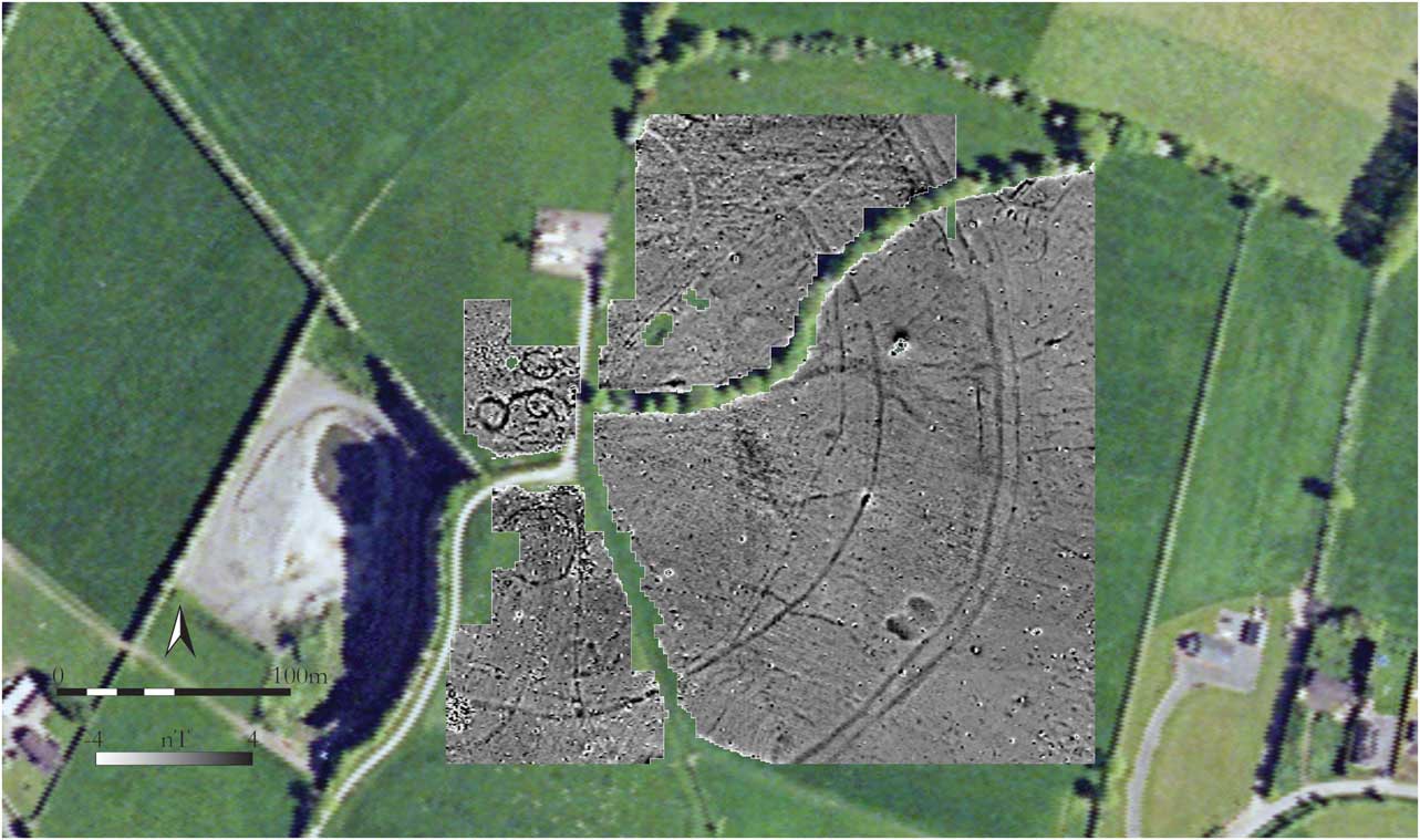
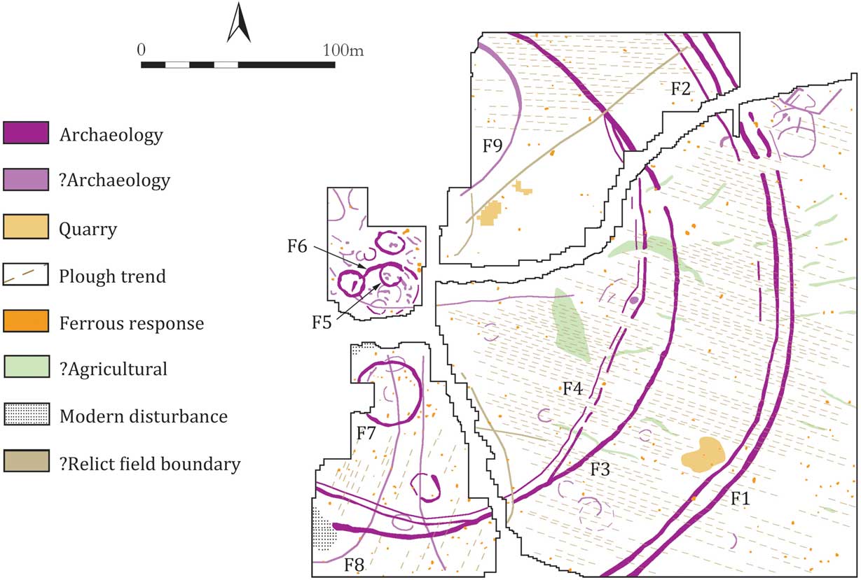
Notwithstanding its physical prominence and commanding prospect, Faughan is distinguished from other important and historically documented sites in the Blackwater Valley by its lack of upstanding archaeological remains. Much of the south-western sector of the hill has been cut away by a modern quarry and, apart from several other, smaller quarries, the only conspicuous features today are the townland boundaries and field divisions that meet near a telecommunications mast on the summit. However, the identification on a 1995 aerial photograph of several curvilinear cropmarks in a field on the southern side of the hill suggested that archaeological features may be present, and this has now been confirmed by geophysical survey across the summit and eastern and southern sectors of the hilltop (total area c. 6.2 ha). Indeed, the array of archaeological features revealed by the survey is quite astounding, comprising portions of what appear to be two very large enclosures – the more substantial of which is described by up to four concentric enclosing elements – as well as numerous smaller enclosures and features of varying size and form (Figs 17 & 18). The positive responses exhibited by the majority of these features suggest they comprise ditches containing enhanced magnetic material in their fills.
Faughan Hill: greyscale image of gradiometry results overlaid on an aerial orthophoto image (Orthophoto © Ordnance Survey of Ireland. All rights reserved. Licence no. EN0059212)

Faughan Hill: interpretative plan showing principal geophysical anomalies

The most striking of the features identified is an enclosure defined by two widely-spaced boundaries, which were traced extending in a semi-circular arc around the eastern side of the hill and can now be seen to be associated with the curvilinear cropmarks visible on aerial imagery to the south. The outer boundary appears to consist of two closely-spaced ditches, set 7–8 m apart (F1), with traces of a third, narrower, ditch, possibly a palisade trench (F2), located a similar distance inside the inner ditch. A well defined gap on the north-east is likely to represent an original entrance to the enclosure, which has a projected overall diameter of approximately 400 m.
Positioned about 50 m inside and concentric with the outer enclosure, the inner enclosure (F3) has a north–south diameter of c. 270 m and is defined by a single ditch with a causeway entrance on the north-east. Though the concentricity and similarly-aligned entrances of the inner and outer enclosures suggest them to be contemporary, this juxtaposition of widely-spaced, single and multi-ditched boundaries is somewhat unusual. Direct comparison can be made, however, with the Late Bronze Age ‘hillfort’ at Rahally, Co. Galway, which was found on excavation to comprise three widely-spaced enclosures, consisting of two single ditches and an outer, double-ditch, with an overall diameter of c. 450 m (Mullins Reference Mullins2009). The deposition pattern of some of the ditch fills at Rahally hinted at the former presence of accompanying banks (ibid.), a configuration that may also have pertained at Faughan. Taking into account both this and some of the broader parallels discussed in relation to the Hill of Lloyd above, a Late Bronze Age, or possibly Iron Age, date is suggested for the hilltop enclosure at Faughan.
Just inside the line of the inner enclosure are traces of what appears to be another large, and potentially earlier, enclosure (F4). It is defined by a pair of closely-spaced lineations, possibly representing narrow ditches and/or slot-trenches, which extend in a broad, angular arc from the north-east boundary of the inner enclosure to the south-west limit of the survey area. The boundary of this putative enclosure may in places have been incorporated into the line of the inner enclosure, which can be seen to flatten out slightly on the south-east, possibly to accommodate it and/or to avoid several small circular features in this area.
Many of the other newly-identified features are concentrated around the relatively small, level area of the summit, though a group of sub-rectangular and linear features located just outside the entrance to the outer enclosure is also of potential interest. Notable among the former are three well-defined, circular, and sub-circular features measuring c. 10–12 m in diameter, which may be classified as ring-ditches, though the uniform circularity of one example (F5) would also be consistent with the slot-trench of a wooden structure or building. Two of the ring-ditches overlap with a semi-circular ditch-type feature which may describe the northern half of an enclosure (F6) of roughly similar dimensions to the 35 m diameter circular enclosure (F7) located a short distance to its south. There are slight suggestions of small circular features at the centre of, and overlapping with, the latter enclosure, which is also bisected north/south by one of a pair of linear features (F8) that splay outwards across the line of the inner hilltop enclosure and continue beyond the limits of the survey. Though not visible topographically, cartographic, and aerial photographic evidence suggests that these lineations may terminate at or near the outer enclosure boundary, thus raising the interesting possibility that they formed some kind of funnel-shaped ‘avenue’ leading to the centre of the enclosure. However, the lack of an entrance in the inner enclosure corresponding with these lineations, and their depiction as part of a decorative woodland on the Ordnance Survey map of c. 1885 (on which the hilltop enclosure is not marked), may indicate a later date and significance for these features. Similar uncertainties surround a large, semi-circular feature of negative magnetic gradient (F9) recorded at the north-west edge of the survey area, which is also shown on historical mapping and survives as a shallow depression, c. 1 m in width.
Discussion
The present study has highlighted the archaeological significance of a number of prominent hilltop sites in a region that has long been a focus for research by the Discovery Programme and other scholars. The array of features mapped by geophysical survey is spectacular, ranging from large-scale enclosures to smaller structures and ring-ditches, with other significant archaeological remains also noted at many sites. The hilltop enclosures vary in form and comparative dating evidence, albeit tentative, suggests they may range in date from the late second to late 1st millennia bc, and possibly later in the case of the inner enclosure on the Hill of Lloyd. Some of the burial monuments at Knockbrack and Faughan, moreover, may pre-date the hilltop enclosures and the occurrence of overlapping archaeological features at these sites also points to multi-period activity, potentially spanning many centuries.
The scale of the hilltop enclosures alone suggests they acted as focal centres for relatively large social groups, each possibly comprising a number of discrete communities. Indeed, while it would be unwise to dismiss the possibility of a residential aspect to activity at these sites, the evidence suggests they were primarily places of assembly, ceremony and burial, and as such, provided an arena for the forging and maintenance of social bonds and group identity. Periodic or seasonal gatherings at such sites may, for instance, have involved religious observances, the negotiation of social contracts (eg marriage) and exchange, as well as feasting, the latter perhaps attested by the dominance of pig among the burnt animal bones from the Late Bronze Age pit/ditch on the summit of the Hill of Lloyd. The deposition of prestige metalwork in Bohermeen Bog and at Phoenixtown well, both in the shadow of Faughan, could, moreover, represent a wider correlate to activity on the hill during the Bronze Age and the late Iron Age.
The identification of the Hill of Lloyd, Faughan Hill, and Knockbrack as prehistoric focal centres of potential regional importance is all the more significant given their proximity to one another and to the Hill of Tara. All three sites lie within a 25 km radius of Tara, with only 10 km separating the Hill of Lloyd from Faughan, which is itself located near two further sites of late prehistoric importance, at Teltown and Tlachtga. How these sites relate to one another and the question of their broader significance in terms of landscape development and social organisation is very difficult to address, however, particularly given the lack of definitive dating evidence and dearth of information on contemporary settlement patterns in their respective hinterlands. That said, some preliminary observations may be put forward.
The strategic, putative boundary, location of the Hill of Lloyd, overlooking the western entry point into the Blackwater Valley, and of Faughan, marking its southern extent, strongly implies an overlapping catchment for these two sites, focused on the river valley (cf. Newman Reference Newman2005, 368–70). However, whether they served as contemporary focal centres, possibly for different social groups, or, as seems more likely, are associated with different phases in the development of this landscape, is as yet far from clear. At a local level, the new archaeological evidence from Faughan suggests that it may at one time have formed the dominant component of a more extensive complex of monuments that extended across the Blackwater to include the Teltown area. Indeed, in contrast to Tlachtga, which appears to have formed the principal focal point of a discrete landscape to the south of Faughan Hill and Bohermeen Bog (ibid., 367–8), it is possible that the historical and symbolic links intimated between Faughan and Teltown in early documentary sources have their roots in later prehistory. Both sites were central to the political and territorial ambitions of the Uí Néill and although it is Teltown that by the 7th century ad emerges as the pre-eminent assembly place within this landscape, the obvious prehistoric importance of Faughan and the ancestral significance claimed for the site as the burial place of Niall of the Nine Hostages suggest that Faughan may have fulfilled a similar role at an earlier period.
An equally significant pedigree is indicated for the hilltop enclosure at Knockbrack, whose putative internally-ditched morphology is, as previously noted, reminiscent of sites like Ráith na Ríg at Tara, Navan Fort and – in terms of size, if not form – the 360 m diameter ditched enclosure at Rathcroghan. Together with its elevated siting and internal mound, the Knockbrack enclosure thus exhibits all the hallmarks of an Iron Age ceremonial site and, like them, is also distinguished by a significant concentration of internal features and the presence of additional burial monuments in its vicinity. Although the survey at nearby Mallahow was more limited in scale, the 25 m diameter enclosure and putative ring-ditch cemetery identified here may denote a site of more local significance, possibly for a group for whom Knockbrack was a regional focal centre. Certainly, the massive size of the Knockbrack enclosure suggests a wide catchment area for the site, potentially extending eastwards as far as the coast and evidenced archaeologically by the matching Roman copper ingots from Damastown and Drumanagh.
Though none of the features mapped by geophysical survey can be definitively ascribed to the Late Iron Age, the presence of Roman and other objects of the early centuries ad in the immediate vicinity of Knockbrack/Mallahow and Faughan, and the strategic and symbolic significances indicated for the sites by early historical sources, likely attest to their continued or renewed importance during this period. In this context, it is worth noting that the archaeological record for the Late Iron Age as a whole illustrates a remarkable degree of continuity in the places used for ceremony and burial, as well as settlement, from the preceding period (Dowling Reference Dowling2014b). While excavation is clearly required to elucidate the broader history of activity at these sites, and in particular the dating of the hilltop enclosures at Knockbrack, the Hill of Lloyd and Faughan – all of which are similar or greater in size than broadly comparable monuments at Tara – the results of the present study serve to emphasise that Tara was not the only major focal centre in this region in later prehistory and may, indeed, as Newman (Reference Newman2005, 379) has suggested, only have assumed a dominant status towards the end of this period.
Acknowledgements
This paper is based on research undertaken as part of the Discovery Programme’s ‘Late Iron Age and ‘Roman’ Ireland’ (LIARI) Project and I would like to thank all my colleagues in the Discovery Programme and on the LIARI Project Committee for their input. The surveys would not have been possible without the generous support of many landowners: Barry McDermott and family (Knockbrack); David Baker and Dan Carmody (Mallahow); Kells Urban District Council (The Hill of Lloyd); and the Moriarty family, Oliver English, and Lawrence McCabe (Faughan Hill). For assistance with the surveys I would especially like to thank: Gary Delvin, Robert Shaw, Anthony Corns, Philippa Barry, Michael Ann Bevinivo, and Patrick Griffin (the Discovery Programme); and Susan Curran, Lorcan Scully, Eileen Cameron, Anita Pinagli, Karen Mulryan, and Emmet Marron, who kindly volunteered their time. The surveys were supported by the ‘ArchaeoLandscapes Europe’ Project (EU Culture 2007–2013). Access to LiDAR data was provided by Fingal County Council, Kells Heritage Park Ltd. and Steve Davis (University College Dublin), while Steve Davis, Fintan Walsh (Irish Archaeological Consultancy Ltd), Patrick Neary (Neary Archaeology), and Martin Jones and Jerry O'Sullivan (Archaeologists, National Roads Authority/Galway County Council) generously made available information on unpublished excavations. I am also grateful to Robert Shaw (the Discovery Programme) for the production of location maps and LiDAR imagery and Edel Bhreathnach for information on early historical source material. Last, but certainly not least, I am greatly indebted to Roseanne Schot for her constructive comments and keen editorial eye.