


1. Introduction
In disaster studies, it has become common to acknowledge that disasters and hazards are not merely natural phenomena. Natural events and hazards can only become a disaster when the societies affected are vulnerable.Footnote 1 The main question, therefore, has become: what types of societies are vulnerable, and what are the root causes of that vulnerability? Peasant societies have often been described as very vulnerable. In three of the most renowned works on vulnerability and disasters, peasant societies have figured prominently on the most vulnerable list.Footnote 2 It is important to define ‘peasant societies’. In this article we use both the concept peasant society as well as peasant community. By peasant society, we refer to a societal model that is dominated by small scale peasant households as defined by Larson. Peasant communities refer to individual village communities or clusters of rural communities. In this article we want to make a clear distinction between the two most important groups within rural societies: farmers and peasants. The main distinguishing feature is not autarky, or absence of markets. Peasants aspire to reach a subsistence level, while farmers have the goal of producing marketable surpluses, which makes them oriented and dependent on the market. Following the definition of Larson: ‘Peasants were primarily small-scale agricultural producers, who controlled the means of production and who used these means directly to provide for their subsistence or use. Their productive activity generally was based around the household unit of immediate family and servants, supplemented by hired labour at key points in the agricultural calendar. Their activities were integrated into the market economy (even if production for the market was not the main goal) but not dependent on markets’.Footnote 3
The level of vulnerability of peasant societies in modern times has been described as high. For example, the ever-shifting commodity frontier, the growing importance of capital and technology from the green revolution and the loss of peasant land because of land grabbing, development and engrossment, have rendered the peasants more unsafe.Footnote 4 Nevertheless, historical peasant societies have often been labelled one of the most vulnerable groups in history as well. Peasants, in contrast with commercial farmers, are believed to have lacked the capital, power, flexibility and technology to respond swiftly and effectively in the face of crisis. This has been put forward in the analysis of coastal floods, sand drifts and deforestation as well as the potato blight in 1845–1847.Footnote 5
For example, in 1845, European but especially Irish peasants were extremely vulnerable to the potato blight, because of the dependence of smallholders on the mono-cultivation of potatoes. Population growth, subdivision of peasant estates and power imbalance towards rural elites and landlords limited their agricultural options. Most peasants were cultivating a highly homogenous variety of potatoes, which was heavily affected by the phythophtera infestans (potato blight). The lack of coping mechanisms of the impoverished peasants caused the potato blight to turn into one of the worst disasters among peasant populations in history, causing mass mortality, immigration and further proletarianisation. Peasants – by definition focusing on subsistence farming – faced severe risks in times of harvest failure.Footnote 6 In contrast to commercial farmers owning large estates, peasants do not have land to provide a surplus nor do they have the storage capacity to stock up. Most peasants provide just enough to reach subsistence levels with just a minor margin to allow some fluctuations. According to Ó Grada and Campbell even a reduction of yields of 15 per cent in two consecutive harvests is enough to lead to disastrous situations.Footnote 7
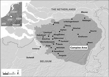
Famine was not the only risk, however. Peasant societies in general were seen as particularly vulnerable towards flooding, sand drifts and other crises.Footnote 8 This article, however, questions whether the picture was that dire. By looking at one particular peasant society, namely the Campine area in the late medieval and early modern Low Countries (Figure 1), we analyse whether peasants were by definition vulnerable to exogenous shocks and crises. We will search for both the vulnerabilities and the strengths of peasant societies in coping with crises.
Map of the selected case study: The Campine area. Map made by Iason Jongepier. GIStorical Antwerp (UAntwerpen/ Hercules Foundation)

After all, more and more case studies have supported the exact opposite argument.Footnote 9 Peasants, being risk averse, independent from the market and operating on small estates, have shown remarkable levels of resilience in both the past as well as the present. For example, Jessica Dijkman and Bas Van Leeuwen have concluded, based on their edited volume, that regarding famines, peasants were often very good at absorbing and coping with shocks, while they less frequently turned to large scale transformations to bounce forward after shocks.Footnote 10 McCloskey stressed the characteristic of the ‘prudent’ peasant. By scattering land holdings and collectively organising arable production, English peasants between the fourteenth and nineteenth century defended themselves against harvest failures and famines.Footnote 11 The same findings apply for historical and present-day Philippine peasants.Footnote 12
Regarding North Sea coastal floods, Tim Soens made the argument that peasant communities were resilient in the later Middle Ages until the peasant model became eroded and marginalised when absentee landlords and capital intensive dyke management replaced the peasant economy.Footnote 13 Similarly, in fourteenth-century England, Daniel Curtis discovered that the peasant communities in the Bourn valley in Cambridgeshire were more resilient towards the pandemics and crises of the beginning of the fourteenth century than their neighbours in East Chilford. The main difference between the two was that in East Chilford, peasant farming with a focus on arable production, labour-intensive strategies and plots of manorial land held by customary tenants was gradually disappearing, whereas it survived in the Bourn valley. Sheep breeding and engrossment in the hands of a few elites had become the norm, which did not provide the means to secure the livelihood of a dense population in the times of the Great Famine and bovine pestilence.Footnote 14
Despite this growing corpus of literature on the vulnerability of peasant societies in the past, it remains unclear whether peasants were inherently vulnerable or resilient towards crisis. Therefore, we want to systematically explore what the weapons of the weak were in the face of crises. Just like Scott in his famous book, we will zoom in on one exemplary peasant society, namely the Campine area. And we will look at how their everyday structures and strategies contributed to their level of vulnerability or resilience. In this analysis, we do not look at large infrastructures or capital-intensive investments, neither at large-scale peasant revolts. We will show how the everyday choices and normal institutional structures impacted the ability of peasant societies to withstand shocks.Footnote 15 For this article, we have tested whether one particular peasant society was resilient or showed high levels of vulnerability towards three different kinds of threats: soil erosion, nature induced harvest failure and economic crisis. There are multiple types and categories of hazards or risks that can be studied.Footnote 16 Our three selected hazards represent an overview of different categories in these typologies. Sand drifts are an extreme example of an insidious hazard, taking decades or even centuries to manifest into a disaster, while nature induced harvest failures are typically very swift events. Economic crises are cyclical events that fall in between the Longue Durée and short-term events. Also, the selected hazards diverge in their endogenous or exogenous character. While we concur with the thesis that all forms of disasters are in a way social events,Footnote 17 some hazards are more endogenous than others. The potato blight or drought-induced harvest failure that struck potato plants and grain fields is of a far more exogenous nature than erosion in the coversand belt or an economic crisis, that could only occur due to societal choices and trends. As a result, we have a diverse and representative sample of hazards or risks a historical peasant society had to face and should try to mitigate.
The region that was selected is the Campine area, in present day Belgium. As we will show later, the Campine area is a quintessential peasant society according to the definition used by Larson. But most importantly, the Campine area was a remarkably stable region regarding the most important institutions, such as its common law, feudal power, property distribution, economic structure and common pool institutions. We have adopted the approach of Van Bavel and Curtis to consider history as a social laboratory to test the impact of shocks. Since the societal blueprint remained virtually unchanged between the thirteenth and the end of the eighteenth century, we have a very long timespan to analyse.Footnote 18 We can assess how the same peasant society coped with different crisis episodes and different types of crisis during the Early Modern period. We overstretch a bit by including one outlier, namely the notorious famine caused by the potato blight in the nineteenth century, because it is revealing how in a peasant society – even when it was experiencing fundamental changes – most of the premodern institutions still had a significant influence. In addition, the wealth of data regarding this crisis allows us to clearly see the causal mechanisms in play. In order to analyse the impact of shocks of such a different nature, we have brought together a broad range of demographic, judicial, and socioeconomic sources. Because of the extensiveness of this range, we will explain the particularities of the sources throughout the corpus of the text.
2. Peasant society: the Campine area
As mentioned above, in this article we focus on the Campine area, where different types of peasant societies continued to exist well into the nineteenth century whilst Coastal Flanders changed towards a highly commercial and unequal society, dominated by absentee landlords and commercial investors.Footnote 19
The case study, Campine area, is delimited by the sandy area in the former Duchy of Brabant that is roughly delimited by the river valleys of the Nethe in the south and south-east, the Scheldt in the West and the Meuse in the North-east (Figure 1).
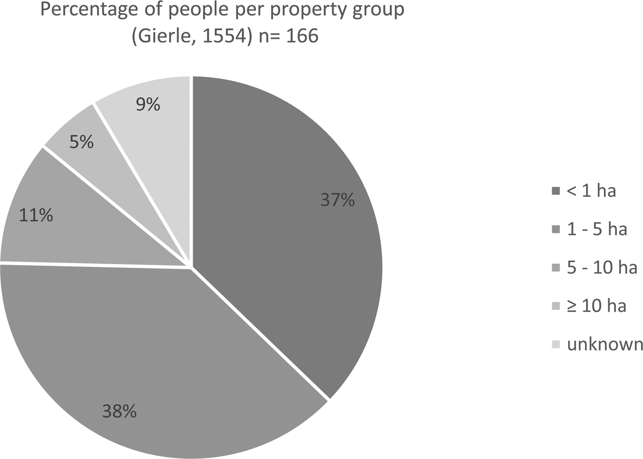
Between at least the thirteenth and the end of the eighteenth century, the area was dominated by small-scale agricultural producers, who had strong property rights in their most crucial capital good: land. We use the village of Gierle, that left a detailed sixteenth-century tax register, or penningkohier, to illustrate this point, but similar distributions have been attested for multiple villages, including Kalmthout-Essen, Loenhout, Brecht and Arendonk.Footnote 20 As Figure 2 shows, an elite farming class was almost absent. Seventy-five per cent of the society existed of peasant households, owning less than five hectares of land. Moreover, only 5 per cent owned more than 10 hectares of land. Until presently, the biggest farm discovered in the Campine area until the sixteenth century was called ‘in vorst’, measured 82 hectares and belonged to the abbey of Tongerlo.Footnote 21 The top 5 per cent were mostly the tenant farmers of ecclesiastical institutions or landlords. These tenant farmers were the odd ones out and were not present in all Campine villages. By the eighteenth century, the Campine area remained a peasant society, maintaining most of the aforementioned characteristics. In contrast to the surrounding regions, absentee landlords or urban investors did not shake up the social composition of society and the village communities were good at defending their privileges and traditions both through symbolic action and in court.Footnote 22 However, the average peasant had even less land when a small group of rural elites did develop. The Campine area was not immune to the relentless trend of rising inequality, attested to in urban regions and Flanders.Footnote 23 In Loenhout, for example, almost all family members of the Van Elsacker family owned or rented around 20 hectares of land.Footnote 24
Household property distribution in the Campine village Gierle. Source: RAA, OGA Gierle, 344. 10th and 20th penny tax (penningkohier), 1554.

The Campine region deserves the label peasant society, rather than feudal or manorial society, because of the weakness of feudal lords.Footnote 25 Between 900 and 1150, most of the land was allodial land. Some families, such as the Berthouts, lords of Duffel, had become powerful and managed to concentrate land into large estates. A real feudalisation process, however, only took place after 1150, when the Dukes of Brabant tried to incorporate the allodial estates into the feudal system. During that same period three Norbertine abbeys were founded in the area, that would become some of the most important lords and landowners, namely Postel, Averbode and Tongerlo. Nevertheless, while the Dukes introduced the feudal system, they immediately undermined it in their struggle to dominate the region. They founded nova oppida, or free urban centres, and granted extensive privileges to entire village communities, including the rights to install village governments and manage the extensive commons. These actions triggered a similar trend in the other feudal or allodial estates. In order not to cause a wave of immigration, the lords, such as the Berthouts, granted similar privileges. The feudal remnants of power were the ability to collect rent, the right to speak justice and collect fines, and some earnings from feudal dues, such as hunting and milling privileges.Footnote 26
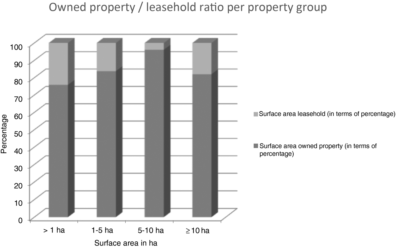
Despite the small-scale nature of their agricultural enterprises, the Campine peasants had two significant advantages between the thirteenth and eighteenth centuries. First, they had strong claims on their private land. The large majority of the land was held in cijns or customary rent which resembles English freehold land, and which was the closest form to absolute private property for a premodern society. As Figure 3 shows, on average only 20 per cent of land in sixteenth-century villages was leased.Footnote 27 Every year a cijns had to be paid to the lord, but the property could be inherited, sold, divided, cultivated or leased at will by the peasants that rented it. In contrast to strongly manorialised regions, no dues or fines were required for most transactions. The concept of ‘pontgeld’, a due of 5 percent on all land transactions, had existed in the Campine area during the late medieval period. In some regions, such as Westerlo (owned by the Merode family), it survived until at least the sixteenth century, but the accounts of the entire land of Turnhout show that in most regions these dues were no longer collected from the later Middle Ages onwards.Footnote 28 Moreover, the cijns paid was a customary sum and therefore, could not be increased or changed in times of inflation or rising land values. Regarding property rights, not much changed throughout the centuries. Customary rent was dominant from at least the middle of the twelfth century until the end of the eighteenth century. Leasehold did become more common by the end of the seventeenth and eighteenth centuries, mostly due to subletting of land held in cijns.Footnote 29
Relationship between customary rent and leasehold for peasant households in Gierle in 1554.
Source: RAA, OGA Gierle, 344. 10th and 20th penny tax (penningkohier), 1554.

Second, all peasant households were able to complement their small plots of privately-owned land with access to the village commons. The Campine area was one of the most inclusive societies regarding communal rights. Access to the commons was granted to all households that were part of the village community. For the village of Zandhoven, it could be proven that 98 per cent of the village community not only had access, but actively used the common waste lands during the sixteenth century.Footnote 30 From the sixteenth century onwards, access was a bit restricted, since immigrants had to show proof of good behaviour and some villages required families to wait a couple of years to become full members of the community of users. Because of the sandy character of the soil, up to 80 per cent of each village was unsuitable as arable land. The most important types of common land were the common heathlands and meadows that could be grazed by cattle and sheep. Arable land, however, was not common and tillage was the individual responsibility of the peasants, without obligatory sowing, harvesting and ploughing cycles.Footnote 31 From the end of the thirteenth century, we have proof that the management of the commons was in the hands of the village community. Even though the lord could intervene in setting the rules, the village representatives – the aldermen – arranged the day-to-day management. In addition, village members could suggest and create new rules.Footnote 32 Proof of this collective action can be found in the village bylaws or common law books. For the Campine area, a collection of bylaws of 24 villages and hamlets has been analysed and will be discussed later in the article.Footnote 33 The longevity of the Campine commons is noteworthy, but not exceptional. The common waste lands and meadows survived until the nineteenth century. In 1772 the Holy Roman Empress Maria Theresa, as ruler of the Habsburg Low Countries, tried to abolish the commons, but the edict had barely any impact due to the following turmoil during the French occupation and revolutions. Only when the new Belgian government reinforced the edict was the fate of the commons sealed.Footnote 34
The goal of the peasant households was subsistence farming. Most households were unable to generate any grain surplus. Each household, even the smallest cottage farmer, had a mixed farming strategy combining grain – mostly rye – production with animal husbandry, some additional wage labour and other activities such as transporting and proto-industrial activities.Footnote 35 Peasants were active on the commodity and even land, labour or financial markets, however these were not predominantly allocated through the market. Peasants used their property as a deposit for long term credit to invest in their farms; they actively sold and bought land as a life cycle strategy and performed labour for a wage. But none of these peasant households was solely dependent on the market for their survival.Footnote 36
This type of peasant society, with a highly egalitarian private property distribution, strong property rights and inclusive common pool institutions, fits the definition of Larson perfectly. This is important to note, because not all societies that have been called peasant societies meet these criteria. Smallholding might have been the norm, but several peasant communities neither had strong claims, nor could they complement these tiny estates with communal benefits. Even where common lands existed, large groups of peasants were often excluded because of a lack of private property or inheritance rights. Finally, in strongly manorialised or feudal regions, surplus extraction and feudal dues could highly affect the independence or means of subsistence of the average peasant household. The difference between the Irish peasants in the nineteenth century and the Campine area, is as big as the difference between highly commercialised farmer societies and peasant societies. The Campine area, therefore, is representative of a particular type of peasant society. Similar peasant societies could be found in several European regions. They are predominantly found in marginalised regions, with mountainous surroundings or infertile soils, where manorial power was weak and commercial investors did not arrive before the communal privileges were bestowed upon the communities. Some examples are Puglia and the Italian Alps, the Spanish highlands around Toledo, Schleswig-Holstein in Denmark, the Camargue and Brittany in France, and English moorlands, fenlands or peak district, to name a few.Footnote 37 While in theory we could have compared the Campine area with another peasant society regarding the way they coped with similar crises, we do not have similar in-depth studies for all the types of crisis. Neither were the same types of data studied together for any of these regions. Therefore, we will retain our rather fragmentary references to other regions and rather compare different time frames and crises within the same case study.
As a result, in this article we will analyse how Campine peasant communities, with strong property claims, communal resources and a relatively egalitarian structure, coped with crises and hazards such as sand drifts, famines and economic crises between the thirteenth and eighteenth centuries.
3. Insidious threats and hazardous shocks
For the Campine area, soil erosion manifested itself as sand drifts, which were an ever-present and insidious threat. As Figure 1 shows, the Campine area was part of the European coversand belt, characterised by sandy soils, made up of loose quartz particles. As long as vegetation covered these soils, the risk was limited. Still, once the subsoil was uncovered because of agricultural practices, overexploitation or ecosystem shifts, the quartz particles could easily start to drift and create sand floods.Footnote 38 This posed a double problem. First, the limited productive soil, consisting of just a couple of fertile centimetres, was blown away, leaving a barren landscape behind. Second, the sand drifts created dunes, possibly covering productive land, wells, and villages. Once dunes become activated, it is difficult to stabilise the sand particles again. Dunes, therefore, pose a continuous risk for rural communities. That the insidious hazard could turn into a disaster becomes clear when we look at Pulle and Nabbegat. Pulle is a village to the east of Zandhoven in the Southern Low Countries (Figure 1) and Nabbegat is a small hamlet in the Northern Low Countries to the east of ‘s Hertogenbosch. Between the tenth and eleventh centuries the village, fields and wells of Pulle were covered by a 2.5-metre-thick layer of sand.Footnote 39 Between the late eighteenth through the nineteenth centuries, the enk or arable fields of Nabbegat were lost due to a swift sand drift that covered the once productive fields.Footnote 40
Surprisingly, however, the Campine area – in contrast with other regions in the European coversand belt – was able to restrict any disastrous sand drifts in between those two events.Footnote 41 Despite sand reactivation on a small scale and some dune growth during the intermediary period, these processes were much slower, and no village or entire arable complex was lost in the process. Recent excavations and Optically Stimulated Luminescence (OSL) dating of Campine dune sites has shown an entirely different pattern of drifting if one compares early medieval and post-eighteenth century drifting with the period in between.Footnote 42 The stabilisation of the soil was mostly due to active management and prevention measures implemented by the village governments. In the Campine area the aldermen, the representatives of the villagers, were responsible for the management and the formulation of regulations. These regulations were written down in bylaws from the fifteenth century onwards and defined the management of the landscape until the end of the eighteenth century. Abidance by the rules and the management of the actual landscape was a collective obligation for all the villagers, supervised by a handful of overseers appointed by the aldermen. Especially regarding sand drifts, the rules became much more detailed and stricter throughout time. As mentioned before, 24 of these bylaws were studied, and they show some very successful measures. Despite their formal judicial character, bylaws evolved over time and show changing policies and solutions.Footnote 43 Several bylaws refer to heather forests, the maintenance of hedges and the necessity to enclose fields.Footnote 44 All of these features can be labelled wind breakers and deterrents of drifting sand. Hedges planted to protect fields and dunes in the surrounding infertile heathlands caught the sand, indicating that the Campine villages managed to prevent the risk to turn into a full blow disaster for multiple centuries.Footnote 45
For this article, we zoom in on two particular food crises. Throughout the premodern period, erratic weather, climatic shifts and plant diseases were a constant challenge for rural communities. One such occasion of extreme weather occurred in the spring, summer and autumn of 1556. In Deurne, a little village in the Dutch part of the Campine area, no significant precipitation was recorded from the middle of March until November. Hay meadows were almost barren, and corn withered away in the fields. Shortages were recorded from the summer of 1556 onwards, while the famine reached its peak during the winter and spring of the next year. There was a shortage of both grains and dairy products.Footnote 46 The analysed sources lack further direct observations for the Campine area. Still, since the sandy region is one of the driest and warmest spots in the Southern Low Countries because of the subsoil, we believe that the situation should have been especially devastating here. In Antwerp, the price of the dominant food grain, rye, rose to 256.86 per cent of the average price of the previous 11 years.Footnote 47 Unfortunately, it is difficult to investigate the actual food availability decline of that year for the Campine area. In the Castellany of Oudenaarde, the harvest of 1557 yielded only 739 l of grain, while the average of the middle of the sixteenth century was 1416 l.Footnote 48
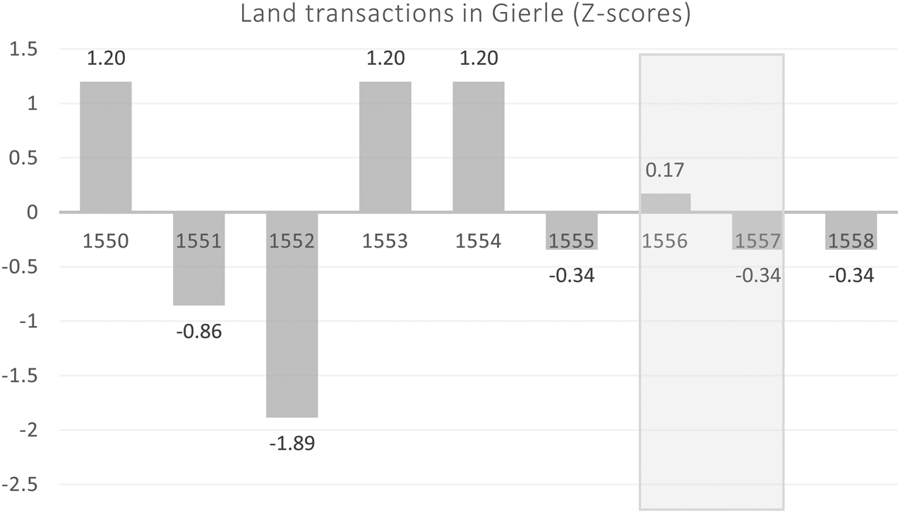
It is not possible to analyse the mortality impact of these food crises since population figures or funeral records are missing for the fifteenth and sixteenth centuries. Nevertheless, analysing the aldermen's registers of Gierle for the period 1550–1557, containing all formal land and credit transactions, it has become clear that in the Campine area peasants rarely had to sell land or engage in credit markets in times of crisis, as we will see.Footnote 49 Even though informal credit and land transactions remain outside of the scope of this source, the aldermen's registers are the only available source to analyse the trend of transactions for the Campine area. Figure 4 shows the land market activity in the village of Gierle in the surroundings of Turnhout between 1550 and 1558. Due to the small number of transactions per year, there are significant fluctuations throughout the period. But most importantly, the graph shows that in the crisis years of 1556 and 1557 less activity on the land market occurred. Emergency transactions, selling of vital acreages of the family farm or engaging in overburdening credit in dire times, discovered for multiple rural regions throughout history, therefore, did not occur during the 1556–1557 crisis in the Campine area.Footnote 50
Z-scores for land market activity of households in Gierle for the period 1550–1558. Grey bar indicates the 1556–1557 crisis.
Source: RAA, OGA Gierle, 344. 10th and 20th penny tax (penningkohier), 1554.

A second nature-induced harvest failure is the notorious potato blight of 1845–1846. The disaster was caused by the fungus phythophtera infestans, which reached Europe by 1845. It is most renowned for the famine and mortality crisis in Ireland, but in fact, it affected much of Europe.Footnote 51 In the Campine area the potato blight affected 80 per cent of the crop, which resembled the losses in other regions that ranged between 90 and 80 per cent, and in 1847 yet again between a third and half of the potatoes were lost. Since in the Campine area only 13 per cent of the crop area was planted with potatoes (compared to 16 per cent in Inland Flanders and 18 per cent in the Walloon area), this was not the biggest problem. In 1846, however, due to bad weather conditions between half and two-thirds of the rye harvest, the dominant crop, were lost as well.Footnote 52
Despite the enormity of the harvest failure and huge similarities regarding the impact of the potato blight and rye harvest failures within the Southern Low Countries during the middle of the nineteenth century, the Campine society showed a remarkable resilience towards this shock. In 1845–1846 the Campine area stood out as one of the Belgian regions with the lowest excess mortality rate, being less than 20 per cent, while some Flemish regions showed a large excess of more than 40 per cent.Footnote 53
Finally, economic crises occur with a cyclical frequency. One of the most renown occasions was the late medieval crisis that affected most of Europe during the fourteenth and fifteenth centuries. The starting and end date of this crisis is mostly unclear and depends on which economic sector one focuses on. For this article we focus on the cyclical movements of the Brabantine rural sectors and industrial activities as described by Van Der Wee. Brabant is the Duchy to which the Campine area belongs. The most important industrial sector was the textile and predominantly cloth industry. Brabant had several bigger and smaller industrial towns or cities, but due to proto-industrial forces, the countryside was involved in the textile industry as well.Footnote 54 It is to be noted that regarding industrial centres, the Campine area can be labelled the periphery.Footnote 55 According to Van Der Wee, the late medieval crisis had many up and downs. The first phase of the crisis started in 1349 with the Black death and lasted until 1378. This was followed by a short recovery, thanks to devaluations and advantages compared to the surrounding regions. Another phase of recession followed in 1399, which lasted till 1406, due to financial troubles and industrial setbacks. The first half of the fifteenth century was a time of economic growth. Especially the industrial sectors such as cloth production were booming. By 1437, however, a new phase of economic decline set in, which lasted until the end of the fifteenth century with its nadir around 1480 when industrial woes and a famine hit the countryside hard.Footnote 56
Nevertheless, for the Campine area, the fourteenth and fifteenth centuries were less bleak than for the surrounding areas. We have looked at the cloth guilds and production centres in the small Campine urban centres, population counts and the economic registers of the Abbey of Tongerlo, the biggest and most important ecclesiastical institution in the area that had farms throughout the region. The records show the grain and cattle yields of the tenant farmers in the Campine area. Unfortunately, detailed and continuous reconstructions of grain and cattle yields for peasant households were not available. Since they had a very similar profile as the average Campine peasant even though on a larger scale, and fragmentary evidence of peasant flock sizes and yields do confirm the trends discussed here, they can function as a proxy to measure the cyclical trends in grain production and cattle breeding.Footnote 57
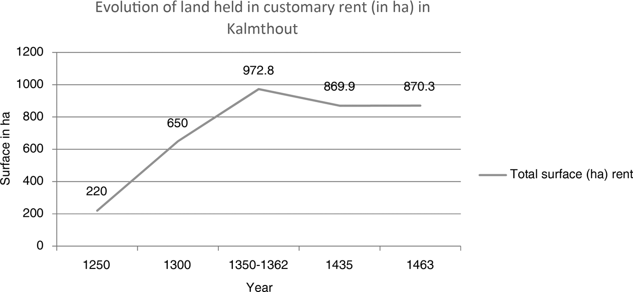
Firstly, as Figure 5 indicates, new land was exploited and cultivated throughout the fourteenth century, and only a tiny fraction was abandoned during the late medieval crisis. Figure 5 is based on the cijns registers of Kalmthout, that mentioned all plots of land held in cijns (a type of customary rent) per household. Since other types of landholding, such as fiefs and leasehold, were still a real exception and only a tiny fraction of the entire region, this source gives an almost complete overview of privatised land in Kalmthout. The total acreage is calculated based on the rent that was paid by every household. A reconstruction was possible because the type of land was mentioned. The mortality crisis of 1349 did take a toll, but the phase of recession after 1437 does not show in the customary rent registers. This stands in stark contrast with the expectations since the Campine area is a typical marginal economy with infertile soils that were the first to be deserted in England during the late medieval crisis.Footnote 58
Total acreage of customary rent in Kalmthout between 1250–1463. Graph based on calculations of Jean Bastiaens.

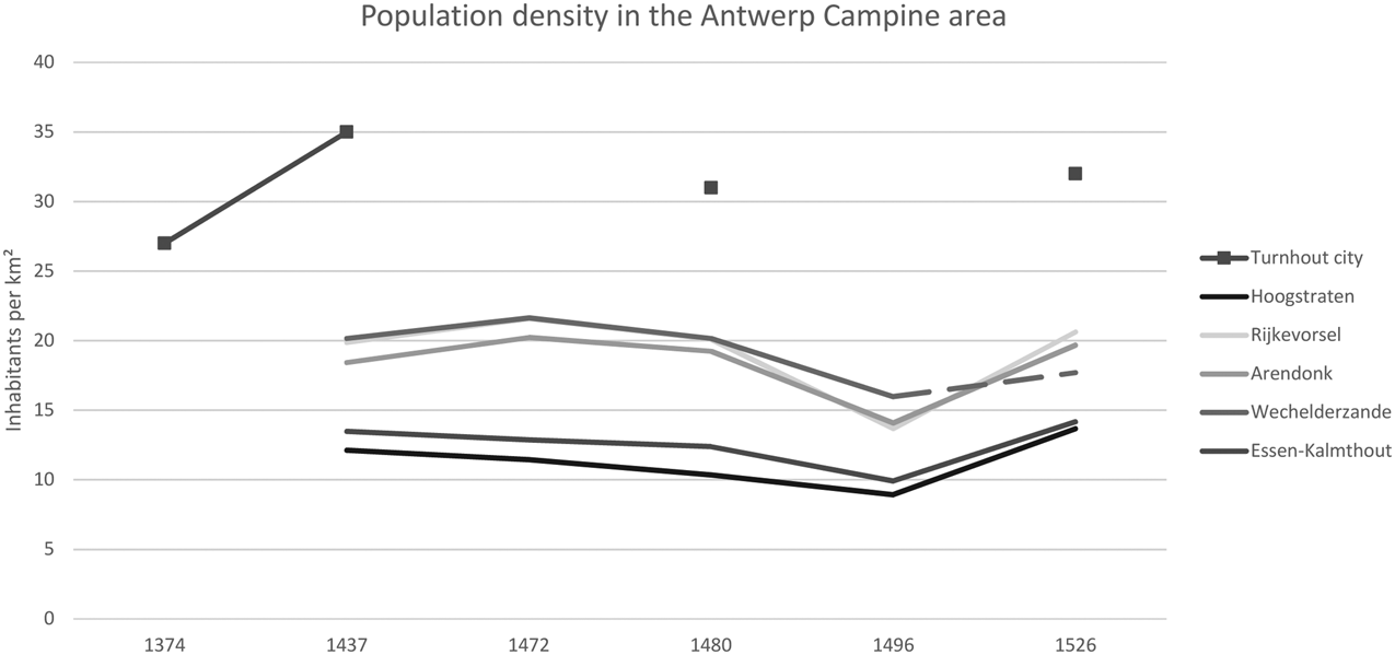
The same picture arises when we look at population figures (Figure 6). The economic decline starting in 1437 is not to be witnessed in the graph. While Van Der Wee discusses large emigration waves of weavers and population decline in the second half of the fifteenth century for the entire Duchy of Brabant, no such trend is visible in the hearth counts of the Campine villages and urban centres. While a dip in the curve is apparent between 1480 and 1526, the overall trend is one of stability between 1374 and 1526. To compare, in Flanders, between 1370 and 1410, the population levels declined significantly.Footnote 59 Unfortunately, no sources are available to look at the demographic impact of the Black Death. Still, the evolution of land in customary rent does suggest that the Black Death did not lead to a fundamental and long-term population decline in the Campine area.
Evolution of the population density in a selection of Campine villages and urban centres, based on the hearth counts and the village surface area.
Source: Cuvelier, Les Dénombrements. The surface area of the villages is based on the historical database of http://www.hisgis.be/nl/start_nl.htm

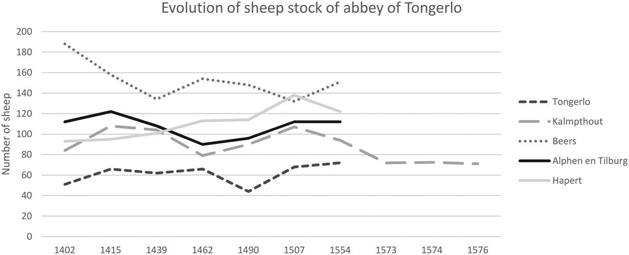
Finally, Figure 7 shows that sheep possession of the abbey of Tongerlo was not as negatively affected by the late medieval crisis and the troubles that affected the cloth industry throughout the Low Countries. The animal counts of the abbey of Tongerlo show the total flock size of the tenant farmers of the abbey. The tenant farmers were not the owners of their livestock but had a specific contract with the abbey, called Kempisch stalrecht. This was a form of shareholding, since half of the flock was owned by the tenant farmer and the other half by the lessor or landlord.Footnote 60 Van Der Wee noted that despite the overall crisis in the cloth industry between 1349 and 1380, especially the Northern part of the Duchy of Brabant showed signs of recovery and growth already from the 1360s onwards. Several urban centres such as Mol, Hoogstraten, Geel, Turnhout and Herentals turned into industrial centres, opened cloth halls or added stalls for selling cloth in other cities.Footnote 61
Total count of sheep on five Tongerlo estates in the Campine area between 1402 and 1576. Based on calculations of Cedric Heerman.Footnote 104

The same lighter touch of crisis is apparent from 1437 onwards. While the Kalmthout and Beerse herds do show a decline in the number of sheep, the Tongerlo and Alphen herds remained stable. In Hapert growth can even be seen. Conversely, Tongerlo was affected by the 1480 nadir of the crisis, while Kalmthout actually showed a recovery. In sum, the abbey estates were affected by the crisis but when taking together the different estates, the total picture is one of stability.
Looking at these three types of hazards and risks, the Campine area showed a remarkable resilience towards exogenous and endogenous shocks. In the following sections, we will discuss the strengths and weaknesses of the Campine peasant system, to explain the outcome during these hazards.
4. Weaknesses
Despite the overall resilience of the Campine peasants towards hazards, the society did have three fundamental weaknesses that made it vulnerable in general, which could deteriorate during crises: land subdivision, a lack of capital and exogenous attacks to the peasant system in general.
First, the Campine peasants held most of their land in customary rent or cijns. As abovementioned, that gave them the right to sell, divide and inherit the land at will. On the one hand, land ownership proved a critical root cause of resilience during the 1845 potato crisis, and strong property claims provided opportunities to adapt their agricultural strategy and restricted the surplus extraction of lords. On the other hand, it was a fundamental threat to the most essential goal of peasant households: subsistence farming. In the Campine area, partial inheritance was dominant during the entire pre-modern period, even though certain areas implemented slightly different systems. In those villages that followed the Antwerp common law, all children received an equal share of the land at the death of their parents. While daughters and younger sons sometimes received annuities or other financial products instead of a part of the property, this customary inheritance system led to the subdivision of land.Footnote 62 Even in the Campine area, one of the least densely populated regions in the Southern Low Countries, the average family farm included less than 5 hectares (Figure 2). This was mostly due to the fact that up to 70–80 per cent of the total acreage of the village was common heath land and could not be added as arable fields or meadows. Therefore, the estate did not provide enough yields to reach a safe subsistence level for an average family.Footnote 63 Van Den Broeck and Soens have calculated for Turnhout that even minor fluctuations in yields put all the households with less than 2.5 hectares of land at risk. Even peasant farms with five hectares did not necessarily have a sufficient buffer capacity to withstand serious harvest failures.Footnote 64 During the 1556 and 1845 harvest failures, a large proportion of the population was, therefore, unable to feed themselves from their produce alone. The absolute majority of the Campine households were reliant on additional services, labour opportunities and resources.
Nevertheless, as we discussed before, mortality peaks, mass emigration, loss of land and other crisis measures were relatively moderate in the Campine area compared to neighbouring regions during the three discussed hazards. The village community provided most of the additional resources and mitigation measures in the form of access to communal lands and charity. Still, as we will discuss later, this was not an unchanging and unwavering right.
Second, the Campine peasant communities, like almost all peasant communities, had a lack of financial capital and technology, which went hand in hand. Elites were virtually absent in the Campine area. Therefore, the accumulation of wealth and the possibility to invest in technological solutions or buffer capacity in times of adversity was limited. While capital accumulation in itself is no guarantee to mitigate crises and elites more than often refused to invest their capital to reduce shocks, the availability of capital could prove vital.Footnote 65 In the Polder society of Zeeland in the Northern Low Countries, the financial strength of the elite farmers was used to develop one of the most technologically advanced levee systems to protect the polder communities from floods.Footnote 66
For the Campine sand drifts, capital investments could have been a solution as well. Most useful were windbreakers such as plantations, hedges, or enclosures around fields to prevent the sand from drifting in the first place or catch the sand and prevent the formation of dunes on unwanted spots once it became active.Footnote 67 Enclosing land or planting windbreaks is a costly endeavour, however. In addition, grazing pressure of cattle and especially sheep was a risk as well. Overgrazing could reduce the soil cover and create barren patches that were prone to drift.Footnote 68 Relying on hay and fodder derived from pastures or nearby regions could alleviate the pressure on the extensive but fragile heathlands, but this again required capital investments to buy or grow enough hay. Neither of these options was easily applied by the Campine peasants and could not be implemented swiftly in times of crisis. As a result, all farmers grazed their cattle and sheep on the common wastelands, and the herds were not limited in size.Footnote 69 In addition, large scale infrastructural projects to stabilise the soil and build windbreaks did not occur. Nevertheless, as we will see later in this article, this vulnerability was countered by relying on labour investments and collective action rather than capital investments.
Finally, but on a somewhat different level, the peasant economy itself was vulnerable from competing systems. Peasant systems can have internal vulnerabilities, but also external weaknesses. Regardless of the efficient crisis measures peasant societies could take, peasant systems themselves could become economically and politically marginalised by more powerful interest groups. All throughout premodern Europe peasant systems transformed because of engrossment practices, proletarianisation, enclosures and market forces. The most renowned process is the enclosure movement or rather movements. Different regions had their own or multiple chronologies, but all communal peasant communities were confronted with enclosures and privatisation movements. This evolution was not limited to merely changing the access to, and ownership of, land but rather the forces at play wanted to transform extensive and communal practices into intensive and specialised agricultural strategies. Open fields turned into pastures, mixed forests with meadows transformed into timber or hunting forests, heathlands were ploughed into fields or planted with trees.Footnote 70 Several peasant communities were also vulnerable to land accumulation and engrossment process by the hand of absentee landlords or rural elites. Due to limited availability of capital and in times of crisis, the land was easily bought up by wealthier interest groups, therefore either expelling or proletarianising the peasant households.Footnote 71
In the Campine area, most of these forces were repelled for a long time. Absentee land ownership and engrossment of estates remained limited until the nineteenth century. This was probably due to the limited amount of land available on the land market because of the common property regime, the infertility of the land and the investment opportunities in the surrounding regions such as Southern Brabant and the Antwerp polders. Most enclosures, apart from some piecemeal enclosures by the peasants themselves, were prevented up until the middle of the eighteenth century by symbolic, collective and judicial actions to maintain communal privileges and rights to the common land. The Campine peasants' agency in court and in the field to stop enclosures and reconfirm their charters and privileges that bestowed the rights to manage and use the commons was strong. Time and again the ducal courts agreed with the complaints or pleas of the Campine peasant communities, therefore preventing large- and small-scale enclosures. The ducal administrations recognized the privileges and charters that peasants could present and acknowledged their rights from time immemorial. This was most probably due to the fact that their predecessors created these charters and that by acknowledging these they thwarted the power of the competing local feudal lords.Footnote 72 Nevertheless, by 1772, when the physiocrats and their patron Maria Theresa orchestrated a top-down attack on collective privileges, the first serious attempt to marginalise common pool institutions took place.Footnote 73 Even though this first endeavour did not result in a large scale transformation, later attempts after 1830, at the nascence of the Belgian state, progressively dismantled the peasant system. Complaints from the peasants had little effect after the turmoil of the French Revolution, and during the nineteenth century all communal lands were privatised or turned into public lands.Footnote 74 This significant judicial change and the land transfers immediately led to a large-scale shift from independent peasant households into industrial labourers or other professions.
By the middle of the nineteenth century, the Campine area was no longer a real peasant society. During this period of transformation, the vulnerability of the Campine society increased. In Nabbegat, precisely during this period of transition, the fields were covered by a swift and thick layer of sand. At the same time, the 1845 potato crisis did cause a mortality peak. Nevertheless, enough elements of resilience were still present at that time that the Campine area showed a remarkably low level of deaths compared to other Flemish and Brabantine regions.Footnote 75
5. Strengths
5.1 Commons
These weaknesses were countered by the three most important strengths and root causes of resilience of the Campine area: the commons, redistribution mechanisms, and economic diversification.
First, in addition to strong property rights, they developed a common property regime. Many peasant societies, though not all of them, held and managed a part of their resources in common.Footnote 76 Common resources could be a significant addition to privately owned land and as such, provided extra resources that peasant households were not able to produce on their private plot of land. Commons, however, are not always a safety net for the average peasant household. This only is true when small peasants have access to communal lands, which was the case in the Campine area as mentioned before. The majority of land was held in common, and the entire village community had access to these communal resources. In some other parts of premodern Europe, however, access to the commons was highly restricted. To manage the pressure on the shared resources, common pool institutions defined strict access rules that became more and more exclusive in times of population growth, urbanisation and commercialisation. The most vulnerable rural dwellers were often the first to lose their access to the commons when requirements such as minimal land ownership, inheritance rights or access fees were introduced.Footnote 77 In those cases, the commons did not constitute a root cause of resilience but rather deteriorated the chances of poorer peasants compared to more privileged rural families.
In the Campine area, the most important and vast common lands were the heathlands, and they were open to all community members, only excluding outsiders, such as recent migrants, neighbouring community members, etc. Moreover, we know that 98 per cent of the Campine peasants actively used the commons.Footnote 78 While infertile, they provided grazing for cattle and sheep, fuel in the form of peat, building materials and clippings or sods to fertilise the arable land of the community members. Next to the heathlands, common hay meadows provided indispensable grazing for community members, all of whom lacked sufficient pastures and private meadows themselves. These additional resources were one of the most important sources of resilience of the Campine peasants. Given the limited size of the household property, living as independent households would have been impossible without the communal lands. The commons and the collective organisation of the village fostered resilience on three levels.
First, as Neeson has stated, being able to keep a cow makes the difference between being independent and becoming a fully dependent labourer.Footnote 79 This reduced the vulnerability to famine in a fundamental and long-lasting way, but it also reduced risk in times of harvest failure. Beeckaert and Vanhaute discovered a correlation between the availability of commons and lower mortality rates during the potato blight in the nineteenth century. The Ardennes and the Campine area are the only two regions that still registered a minimum of 10 per cent communal land in 1859.Footnote 80 Since the large-scale privatisation movement only started in 1830, the size of communal lands must have been significantly larger during the 1840s. In addition, both peasant communities provided strong property rights on private land as well as common land. In the Ardennes and the Campine area, more than 45 and in most areas more than 65 per cent of all private land was held in full property, while in most of Flanders less than 40 or even 20 per cent was not leasehold.Footnote 81 This correlates with mortality figures of 19 and 20 per cent during the crisis, while Inland Flanders registered an excess mortality of 40 per cent in 1847.Footnote 82
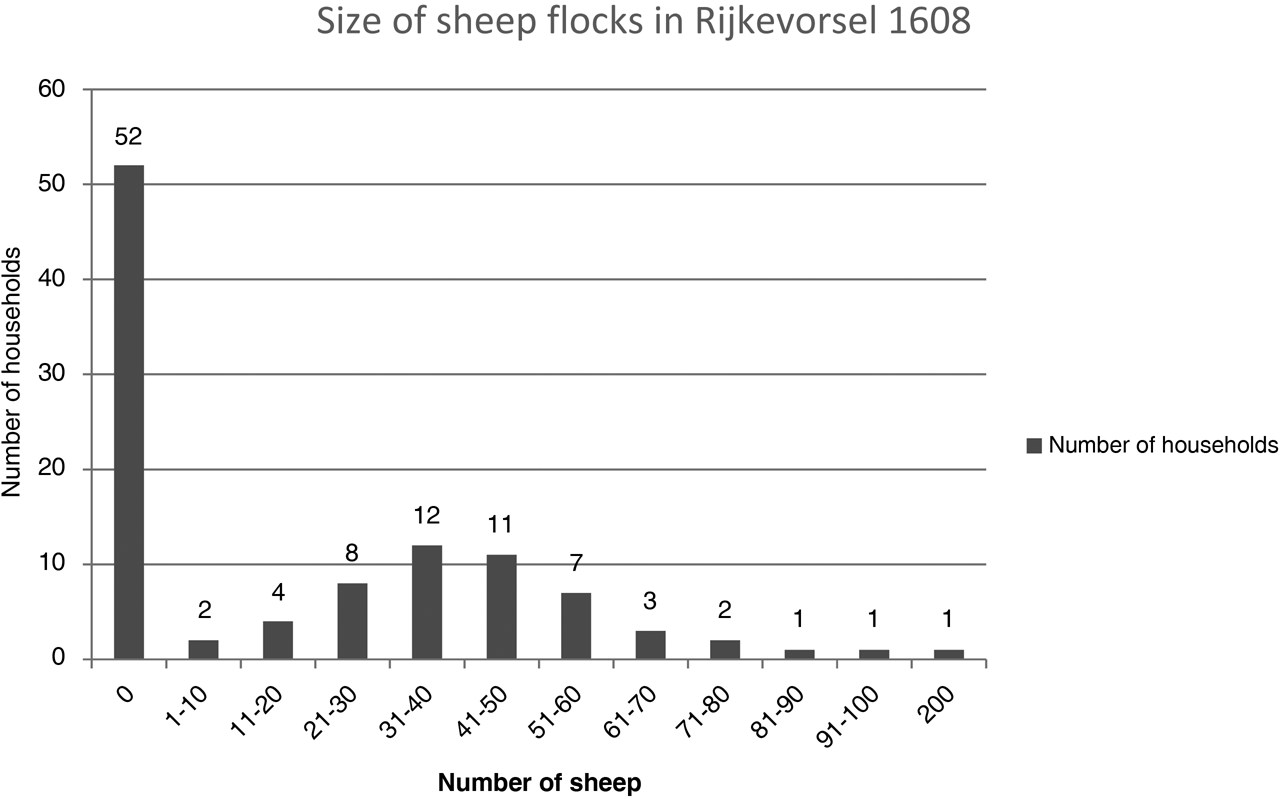
Second, the commons provided ‘free land’ or ‘ghost acres’ to the Campine peasants, which allowed them to engage in more agricultural activities than their individual means did. Looking at all available animal counts for the end of the sixteenth and beginning of the seventeenth century, we have reconstructed peasant sheep herds for several villages, including Brecht, Loenhout, Wortel, Alphen, Nispen, Kalmthout and Rijkevorsel.Footnote 83 While most families did not have any sheep, in general the top 30 per cent of the village was engaged in sheep breeding and sold wool, hides and meat on the local and regional markets, even though they owned only around 5 hectares of land. The average flock was approximately between 20 and 60 sheep (Figure 8), while sheep-owning peasants could only feed around 2 or 3 cattle units on their private meadows.Footnote 84
Sheep possession in the village of Rijkevorsel in 1608.
Source: RAA, OGA Rijkevorsel, 3141–3149, Animal counts, 1608.

The availability of vast heathlands provided Campine peasants with the opportunity to invest in sheep, without having to invest in extra land or to specialise in sheep breeding. The peasants owning sheep could combine sheep breeding with maintaining a couple of cattle, a draft horse and arable production.Footnote 85 The peasants did not opt to target the luxury market that sought after the highest quality wool. They aimed at the more constant demand for lesser quality wool for basic necessities on the regional and local markets, which was much less sensitive to international textile crises.Footnote 86 This explains why the flocks of sheep showed such remarkable stability, even during the late medieval crisis in the fifteenth century (Figure 7). A household owning a flock of sheep could potentially earn an additional income equal to thirty days of wages as a skilled urban mason.Footnote 87 As a result, the commons added significantly to the standard of living and income of a large portion of Campine peasants.
Third, the Campine peasants did more than just share resources. They created common pool institutions, and they developed a real communal society. This collective action proved vital in tackling the insidious hazard of sand drifts. While the peasants lacked capital and sophisticated technological solutions, they tapped into their most crucial resource: labour. The village bylaws stated that all community members were obliged to collectively check, maintain and replant the woodlands or heather forests which functioned as windbreaks and stabilised the sand layers in the communal heathlands. The villages of Retie, Kalmthout, Ravels, Geel and Arendonk all refer to small plantations or wooded areas, called heibossen (heather forests), that were constructed on the wastelands in order to prevent or limit drifts.Footnote 88 In addition, everybody was obliged to maintain the fences and hedges around their fields and cover peat pits or loam digging sites so as to prevent drifting. Finally, grazing was off-limits within zones that were prone to drift and that were delimited by the appointed officials of the village called aardmeesters. Abidance by the rules was secured by implementing fines, but most importantly, by social control.Footnote 89
Peasants that built a communal society with substantial common lands, therefore, created robust institutions and practices that lowered overall vulnerability levels which also withstood insidious and swift shocks. When all peasant households were allowed to access and exploit the common lands, they provided the buffer capacity that none of the individual households themselves could guarantee. As stated before, they provided the hardware to develop a diverse economic portfolio that constitutes the second strength that we want to discuss.
5.2 Diversification
Diversification is the key concept of the peasant enterprise. Peasants, as opposed to commercial farmers, were active on the commodity and factor markets during the entire study period. They sold some of their produce, they had active credit and land markets, and wage labour was limited but present. Still, in general, they actively opted not to become dependent on these markets, nor did they specialise in one type of commodity. In Coastal Flanders or Holland, for example, two of the most commercially oriented rural regions in the Low Countries, farmers specialised in cattle breeding, dairy or grain production.Footnote 90 In the Campine area, all peasants, from the smallest cottagers to the largest tenant farmers, produced rye. However, this was not a grain- exporting region and different types of grain, mainly rye, oats and buckwheat, were grown by the same households.Footnote 91
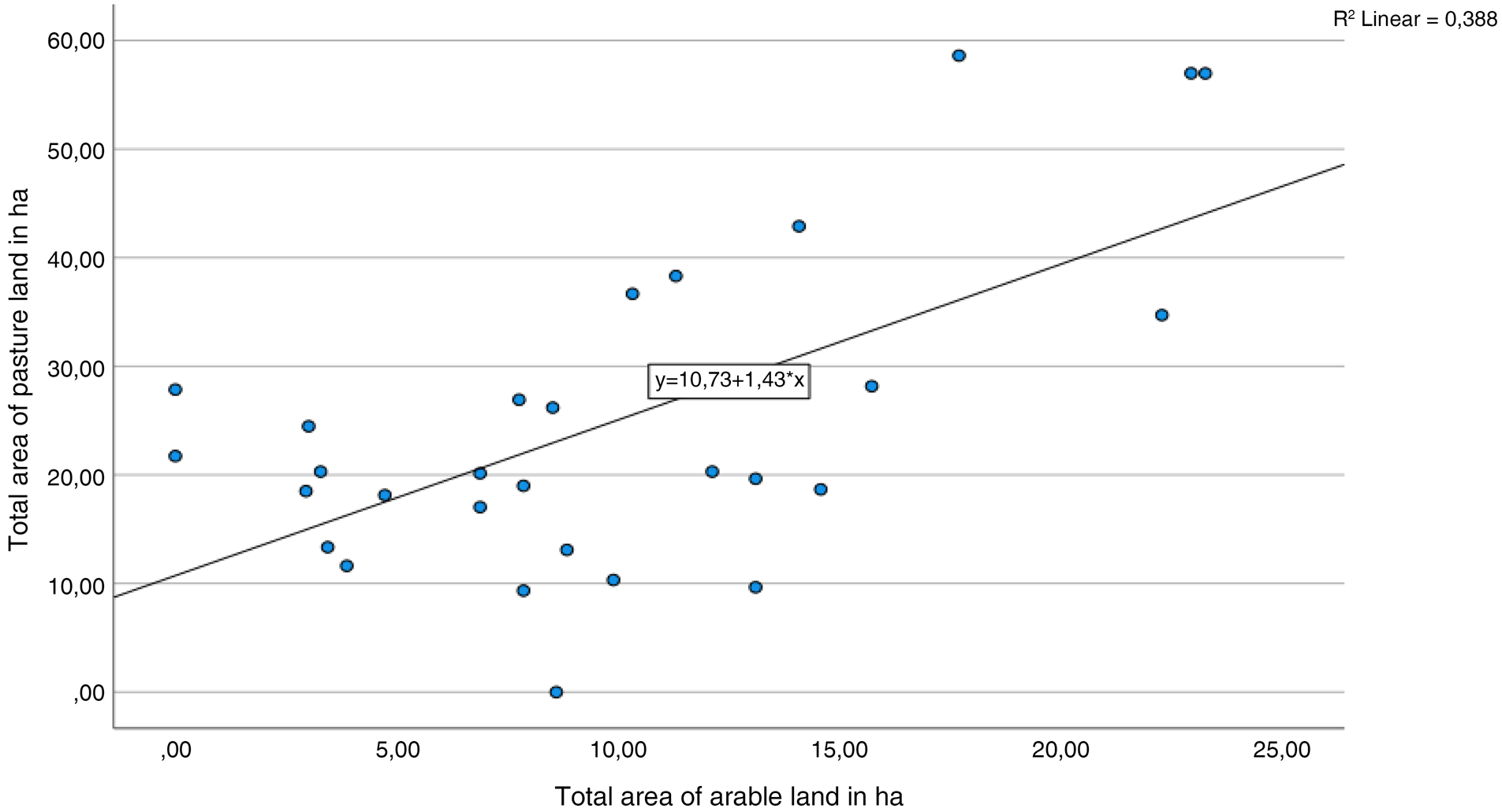
Looking at the animal counts mentioned before, 80 per cent of all households possessed at least one cow, and peasant estates existed of as much pasture and meadows as arable land.Footnote 92 Thanks to detailed tax registers and farm descriptions of the abbey of Tongerlo, we know that a rise in arable land was accompanied by an increase in grazing land (Figure 9). Here diversification was key as well. Campine peasants did not invest exclusively in dairy, meat, or draft animals; rather, they combined several types of animal husbandry. In the sixteenth century a remarkably large group, constituting 40 per cent of all households owned a horse. Moreover, in the accounts of the abbey of Tongerlo all types of cattle were found, and hides and meat as well as live animals were sold.Footnote 93 Also, sheep, the most suitable animals on the Campine heathlands, were always combined with the former two practices. The fact that the choice of the Campine peasants was deliberate and not dictated by the subsoil or environmental conditions is shown if we look at other areas in the European coversand belt. For example, in the Brecklands, ecologically a very similar region to the Campine area in East Anglia, the rural elites as well as peasants replaced mixed farming by specialisation. The comparative advantages of a sandy region were exploited to invest in large scale and commercial rabbit warrens and sheep flocks.Footnote 94
Scatterplot showing the correlation between the surface area of pastures and arable land in the tenant estates of the abbey of Tongerlo in the sixteenth century.
Source: AAT, Section II, 292–293 Farm descriptions.

The diversification process did have a positive influence on food availability for the Campine peasants. The eighteenth-century probate inventories of the village Loenhout show an abundance of milk, milk cows and chickens in the Campine households and even a surprising presence of cured and processed meat such as bacon. Sixty-seven per cent of all probate inventories show at least one source of protein and most show multiple sources (namely milk, chickens and meat).Footnote 95 Most of the protein was derived from the abundance of cattle that were present in the village. Almost all the probate inventories that registered sources of protein listed dairy processing equipment and milch cattle. And even while perishable food normally is not registered in probate inventories, still around twenty per cent of the inventories list bacon or tongue meat. This probably is an underestimation because it was not required to list these goods. In a time when protein intake dipped to an absolute low point in Europe, access to the commons provided the Campine peasants with the opportunity to diversify their food production and consumption, even in times of crisis.Footnote 96
Next to purely agricultural strategies, the Campine peasants added extra activities. Bart Ballaux discovered that Campine peasants were strongly present in the transport services to and from Antwerp.Footnote 97 The widespread ownership of horses was an asset in this regard. Proto-industrial activities probably remained limited until at least the seventeenth century, but this conclusion may be affected by a lack of sources. In the eighteenth century, 37 per cent of all households of Loenhout owned at least one spinning wheel and must have been active in wool or flax processing as a part-time activity.Footnote 98
It has been shown time and again that a dependence on monoculture or one type of business rendered communities vulnerable. The proto-industrial heartland in Inland Flanders was struck hard in the nineteenth century because of their absolute reliance on potatoes and linen production.Footnote 99 In Cambresis, one of the most productive grain-producing regions, famines were a recurring phenomenon well into the eighteenth century.Footnote 100 For the Campine peasants, who resolutely opted for subsistence and mixed farming, large profits and commercial gains were always out of reach. Still, they proved remarkably resilient during both the late medieval crisis and both periods of harvest failure.
5.3 Poor relief
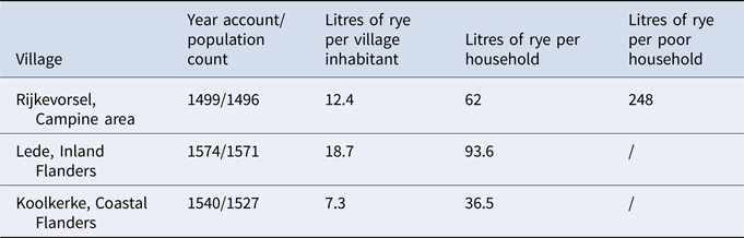
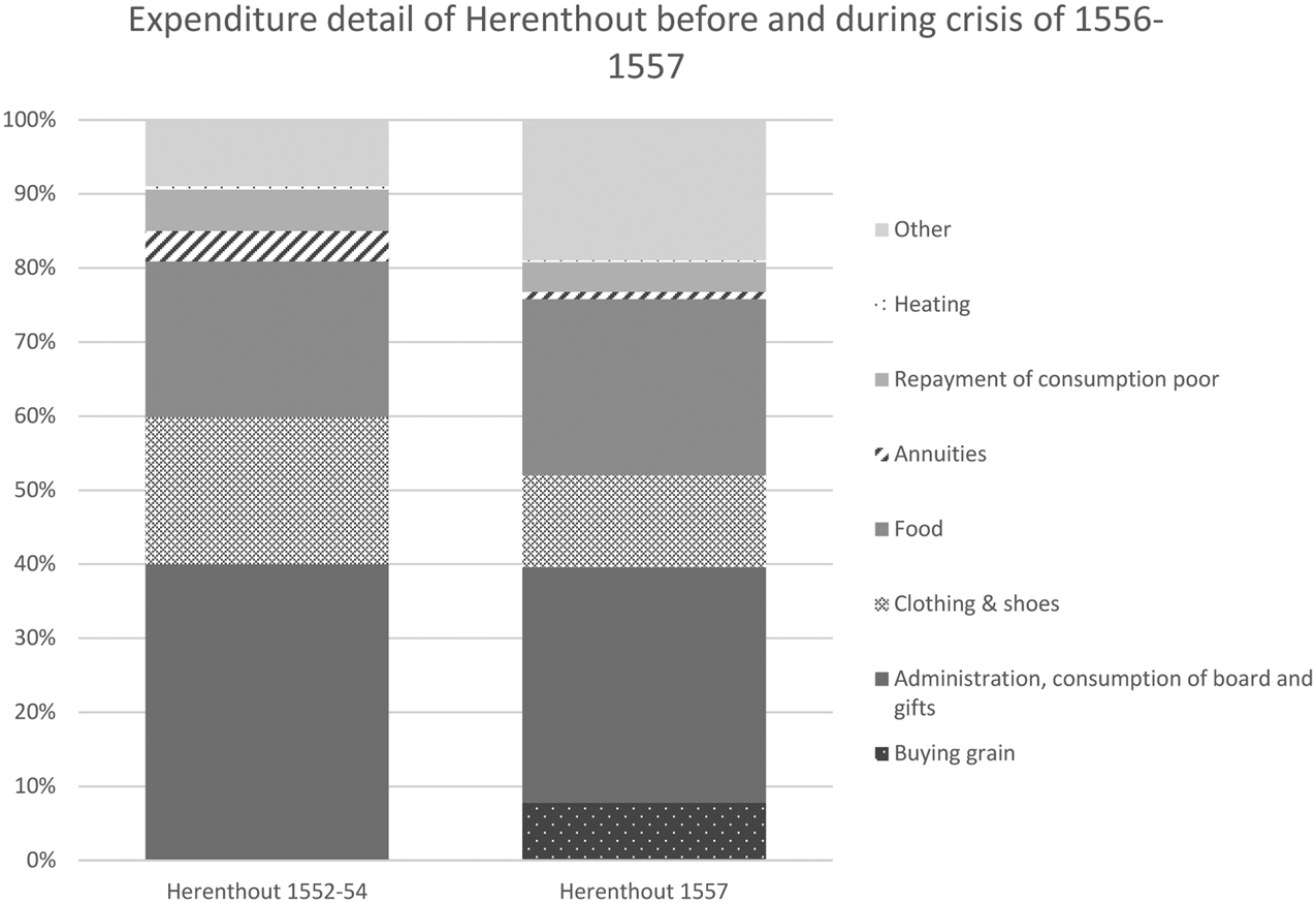
Finally, when these two overall institutional factors of resilience proved insufficient, the third root cause of resilience functioned as a safety net: charity or redistribution mechanisms. In the Campine area, as everywhere in the Low Countries, poor tables called the Holy Ghost Tables were the formalised institution organising relief and charity.Footnote 101 For this article, we studied three poor tables: the sixteenth century Holy Ghost tables of Herenthout, Rijkevorsel and Brecht. Two things stand out for the Campine area, however. First, the poor tables got most of their revenues in kind rather than specie.Footnote 102 While this was atypical in the heavily commercialised Low Countries, it proved useful in times of harvest failures when grain prices increased enormously. The poor table always had a ready supply of grain to redistribute without having to rely on the grain market. Second, the Campine poor tables provided substantial relief even in non-crisis years (Table 1). This becomes apparent if we look at the expenditure of the Campine poor tables, compared to other rural communities. When compared with commercial farming regions, peasant poor tables such as in Herenthout provided much more substantial sums and more sustained relief to its members. As Table 1 shows, Lede and Rijkevorsel, both typical peasant communities, provided more substantial relief, regardless of crisis or not, than Koolkerke, a typical commercialised polder society. In addition, as Figure 10 shows, this relief entailed a wide range of goods and services.
Extent of poor relief in Rijkevorsel, compared to two different rural communities in Flanders

Source: RABr, Kerkfabriek Oostkerke, inv. nr. 149–154, 1530–1590; RAB, OGA Lede, inv. nr. 471–503, 1456–1591; RAA, OGA Rijkevorsel, inv. nr. 4058–4098, 1490–1599; RAA, Rekeningen van de Heilige Geesttafel van de Sint Pieterskerk te Vorselaar, inv. nr. 396–402, 1552–1568.
Expenditure of the poor table of Herenthout in 1552–1554 and 1557.
Source: RAA, Archief van St.-Gummarus en St.-Pieterskerk te Herenthout, 330, 1546–1575.

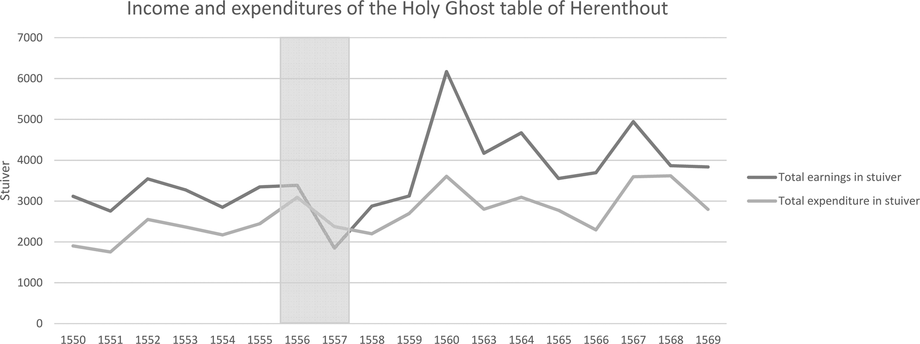
During the crisis of 1556–1557, the total amount spent on relief did not rise significantly, since the earnings of the poor table were very inflexible. The income of the poor tables was not based on taxes, but rather on annuities and revenues from rents and land. Nevertheless, the poor table of Herenthout did attempt to counter the crisis. They acted countercyclical by spending more than they earned that year (Figure 11), and they reshuffled their spending, cutting back on gifts, administration costs and clothing, while overspending on food (Figure 10). The poor table invested in buying additional grain, which was highly unusual for this institution throughout its history.
Comparison of the total income and expenditure of the Holy Ghost table of Herenthout between 1550 and 1569. Grey bar indicates the crisis if 1556–1557.
Source: RAA, Archief van St.-Gummarus en St.-Pieterskerk te Herenthout, 330, 1546–1575.

Similar findings are established for the 1845–1846 potato crisis. Even though poor relief was less necessary in the Campine area than in other Flemish and Brabantine regions because of the generally more robust institutions discussed above, the omnipresent formal poor tables did provide a subsidy of 10 francs per indigent, while only 0.92 and 7 francs were spent in Walloon Brabant and Inland Flanders respectively.Footnote 103
6. Conclusion
While peasant societies have often been deemed vulnerable, our case study of the Campine area between the thirteenth and middle of the nineteenth century shows that peasants societies could be very resilient in tackling insidious hazards as well as sudden shocks. The Campine peasant communities became resilient towards shocks and insidious hazards because of three specific conditions. First, they combined their strong property claims on their small estates with common pool resources. This provided ‘ghost acres’, which their private means could never obtain. Importantly, resources were not only held in common, but the Campine community members also acted collectively and harboured the power of communal labour to fend against the constant hazard of sand drifts. Because of these continuous and collective endeavours, disastrous sand drifts were kept at bay between the twelfth and late eighteenth centuries. Moreover, the commons allowed them to diversify their agricultural strategies and built a buffer against, for example, the harvest failures of 1556–1557 and 1845–1846.
Second, the Campine peasants resolutely opted to combine mixed farming with other economic activities without specialising or becoming dependent on the commodity markets as much as possible. This made them more crisis resilient during the late medieval crisis. Finally, the Campine peasants showed solidarity to those in need. The poor tables that redistributed food and resources to the poor on a permanent basis acted countercyclically and helped those families for whom the other two institutional settings of resilience were insufficient during crises.
It is important not to overstate the level of resilience of peasants, nor to generalise these findings. Peasant societies did have some inherent weaknesses. Small landownership prevented peasant households from having a large buffer capacity of food or capital which could be used in times of crisis. While poor relief and redistribution measures could create a collective buffer capacity, the example of the Holy Ghost tables has shown that their total income to provide for such relief was inelastic and could not increase spending beyond certain limited thresholds. Peasant societies were able to invest labour and time in mitigating disasters, but capital-intensive solutions, such as technology, were often out of reach. Also, not all peasant communities in the past had the three strengths the Campine peasants had. Commons were not a universal feature of peasant communities, nor did all common pool institutions allow all the members of the community to benefit from the collective resources. The same goes for the diversification of economic activities. Finally, peasant communities were vulnerable to attacks on their societal model from other interest groups.