Introduction
The Earth’s climate has been known to change periodically and during the last ∽2.8 Ma, cold glacial periods have alternated with shorter, warmer interglacial periods. The last glacial period came to an end ∽11 500 years ago (cal years BP), and the onset of the Holocene is marked by a large and abrupt rise in global temperatures (∽78C; Reference Sveinbjörnsdóttir and JohnsenSveinbjörnsdottir and Johnsen, 1990). Although the Holocene climate can be regarded as stable when compared to observed climate oscillations in the past 150 000 years (e.g. GRIP Members, 1993), significant Holocene climate oscillations have been identified with as many as six periods of rapid climate change (Reference MayewskiMayewski and others, 2004).
Paleoclimate proxies and reconstructions indicate a Holocene thermal maximum around Iceland between 10 200 and 7000 cal years BP and again from 5500 to 4500 cal years BP, with a major cooling event between 8600 and 8000 cal years BP (Reference Knudsen, Jiang, Jansen, Eiríksson, Heinemeier and SeidenkrantzKnudsen and others, 2004). Kaufman and others (2004) noted that the thermal maximum in Iceland seems to have occurred somewhat later, or between 8000 and 6000 cal years BP. The paleoclimate record indicates that at times it was warm enough in Iceland during the Holocene for glaciers to disappear, but the critical question is how this can be verified. One method of assessing this question is to measure volatiles in tephra deposits.
Microprobe analysis of sulphur in phreatomagmatic and magmatic tephra and melt inclusions reveals distinct differences in their S contents (Reference Metrich, Sigurdsson, Meyer and DevineMetrich and others, 1991; Reference Thordarson, Self, Óskarsson and HulseboeschThordarson and others, 1996, Reference Thordarson, Miller, Larsen, Self and Sigurdsson2001, Reference Thordarson, Self, Miller, Larsen, Vilmundardóttir, Oppenheimer, Pyle and Barclay2003). The melt inclusions demonstrate undegassed S concentration whereas the difference in magmatic versus phreatomagmatic tephra is directly linked to the contrasting eruption mechanisms. In magmatic eruptions the gas escapes readily from the low viscosity melt and the degassing is carried out to near-completion when the magma emerges from the vents. Therefore, the glass grains of magmatic tephra are low in residual volatiles such as S. In phreatomagmatic eruptions, on the other hand, the degassing is abruptly ceased in actively vesiculating magma at shallow conduit levels (i.e. the top 500–1000 m) due to explosive interactions of magma and external water resulting in moderately high and variable S contents (Reference Thordarson, Self, Óskarsson and HulseboeschThordarson and others, 1996, Reference Thordarson, Miller, Larsen, Self and Sigurdsson2001).
In this paper we address the glacial history of Mýrdalsjökull in southern Iceland over the last 8400 years. Our approach is to measure sulphur concentration in tephra produced by Holocene eruptions at the Katla volcano, which is today covered by the Mýrdalsjökull ice cap. The sulphur concentration in melt inclusions and fully degassed magma from the Katla volcano has already been analyzed and modelled (Reference Thordarson, Self, Miller, Larsen, Vilmundardóttir, Oppenheimer, Pyle and BarclayThordarson and others, 2003). By using this model and knowing that the Katla volcano has erupted regularly during the Holocene (Reference Oladottir, Larsen, Thordarson and SigmarssonOladottir and others, 2005), any changes from phreatomagmatic (subglacial) to magmatic (ice-free) eruption styles should be detectable in the measured sulphur concentration in the tephra clasts. If Katla volcano was ice-free at any stage, the eruptions should produce fully degassed magmatic tephra. In the interval from about 9000–2700 years ago (8000–2500 14-C years BP), the climate in Iceland was drier and warmer than it is today and it has been suggested that it was warm enough for ice caps to disappear entirely (Reference BjörnssonBjörnsson, 1979). Thus, if the Mýrdalsjökull ice cap did disappear it most likely did so during this period, which should then be represented by low S concentrations in the analyzed tephra.
Geological Settings
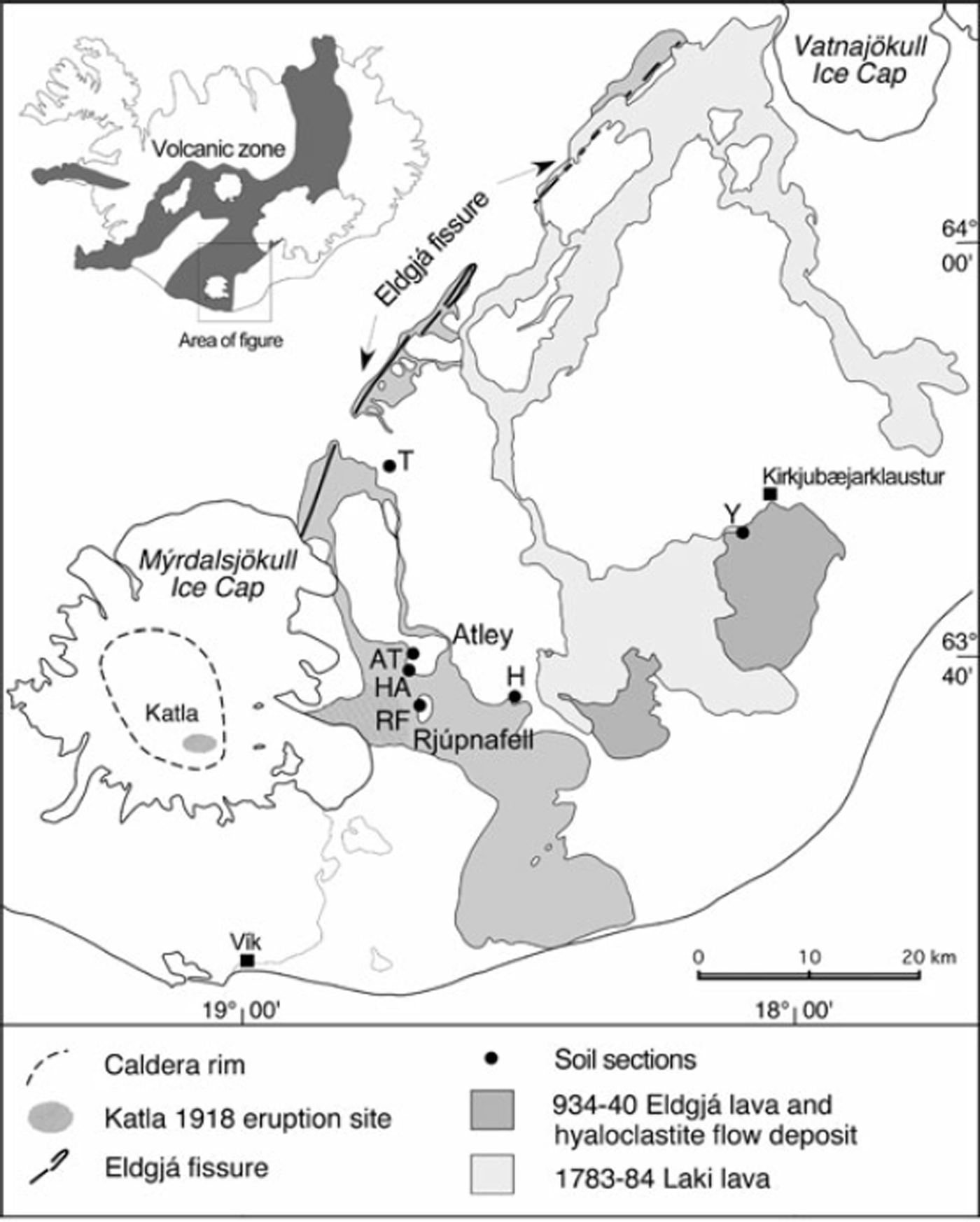
The Katla volcanic system is situated on the propagating Eastern Volcanic Zone (EVZ) in southern Iceland. The system is 80 km long, comprising the ice-capped central volcano, Katla, and a southwest–northeast trending fissure swarm (Fig. 1). It has been active since the penultimate glaciation (Reference JakobssonJakobsson, 1979). Katla is 30–35km in diameter at the base, narrowing to 20km at 700m elevation. It is crowned by a 650–750m deep caldera that is surrounded by 1300– 1380m high mountains and has an area of 100 km2 (Reference Björnsson, Pálsson and GuðmundssonBjörnsson and others, 2000). The caldera floor has an elevation of 650–1000 m, dropping towards the north. The caldera walls have been breached by glacial erosion in several places and the lowest pass is at ∽740m (Reference Björnsson, Pálsson and GuðmundssonBjörnsson and others, 2000).
Katla volcanic system located in southern Iceland, showing the central volcano caldera and the northeast-trending fissure swarm. The locations of the measured soil profiles are indicated: Atley (AT and HA), Rjúpnafell (RF), Hrífunes (H), Ytri-Dalbær (Y) and Tjaldgilsháls (T) (after Reference Oladottir, Larsen, Thordarson and SigmarssonOladottir and others, 2005).
Mýrdalsjökull, which caps the Katla volcano, is the fourth largest glacier in Iceland (590km2) and rises to 1450 m a.s.l. It has an average thickness of 230 m and the total ice volume is ∽140km3. The glacier is thickest in the northern part of the caldera, ∽740 m, and the total ice volume inside the caldera has been estimated as 45 km3 (Reference Björnsson, Pálsson and GuðmundssonBjörnsson and others, 2000).
Three types of eruptions have occurred in the Katla volcanic system during the Holocene: (1) explosive basaltic (phreatomagmatic eruptions); (2) explosive silicic eruptions that are confined to the central volcano; and (3) effusive basaltic fissure eruptions that take place on the ice-free fissure swarm (Reference LarsenLarsen, 2000). The most frequent type is the explosive basaltic eruption, and the least common is the fissure eruption. The source vents of the explosive historical Katla eruptions have been short fissures situated within the caldera or along bounding caldera faults. In most recent times (i.e. since the 13th century) the activity has been confined to the eastern part of the caldera (e.g. Reference LarsenLarsen, 2000). Katla is characterized by Fe-Ti basalt magmatism, although intermediate and silicic rocks represent a minor component in the erupted products (e.g. Reference JakobssonJakobsson, 1979; Reference Lacasse, Sigurdsson, Jóhannesson, Paterne and CareyLacasse and others, 1995; Reference Jóhannesson and SæmundssonJóhannesson and Sæmundsson, 1998; Reference Larsen, Newton, Dugmore and VilmundardóttirLarsen and others, 2001; Reference Thordarson, Miller, Larsen, Self and SigurdssonThordarson and others, 2001).
Within historical time (last ∽1100 years), the Katla volcanic system has been the fourth most active system in Iceland with 21 recorded eruptions since 870 AD. The eruption chronology reveals 1–3 eruptions per century, with an average repose time of 47 years between events since 1500 AD (Reference LarsenLarsen, 2000). All but one of the historical eruptions were explosive subglacial basalt eruptions that took place on fissures within or along the periphery of the caldera. These eruptions have produced widespread tephra layers with volumes ranging from 0.02–1.5km3 (Thorarins-son, 1975; Reference LarsenLarsen, 2000). The only historical eruption in the Katla system outside of the central volcano was the 934– 940 AD Eldgjá Fire fissure eruption that took place on a discontinuous 75 km long southwest–northeast trending volcanic fissure that produced 18.3 km3 of lava and 1.3 km3 of tephra (Reference LarsenLarsen, 2000; Reference Thordarson, Miller, Larsen, Self and SigurdssonThordarson and others, 2001).
In prehistoric time, the average frequency of explosive basaltic eruptions was higher than in historical time with ∽4 eruptions per century (Reference Oladottir, Larsen, Thordarson and SigmarssonOladottir and others, 2005). At least 12 felsic eruptions were also produced during this time as well as 8–10 fissure eruptions (Reference Jóhannesson, Jakobsson and SæmundssonJóhannesson and others, 1990; Reference LarsenLarsen, 2000). The total number of explosive basalt eruptions from Katla in the last ∽8400 years is ∽300, which should be regarded as a conservative estimate (Reference Oladottir, Larsen, Thordarson and SigmarssonOladottir and others, 2005).
Methods
Fieldwork
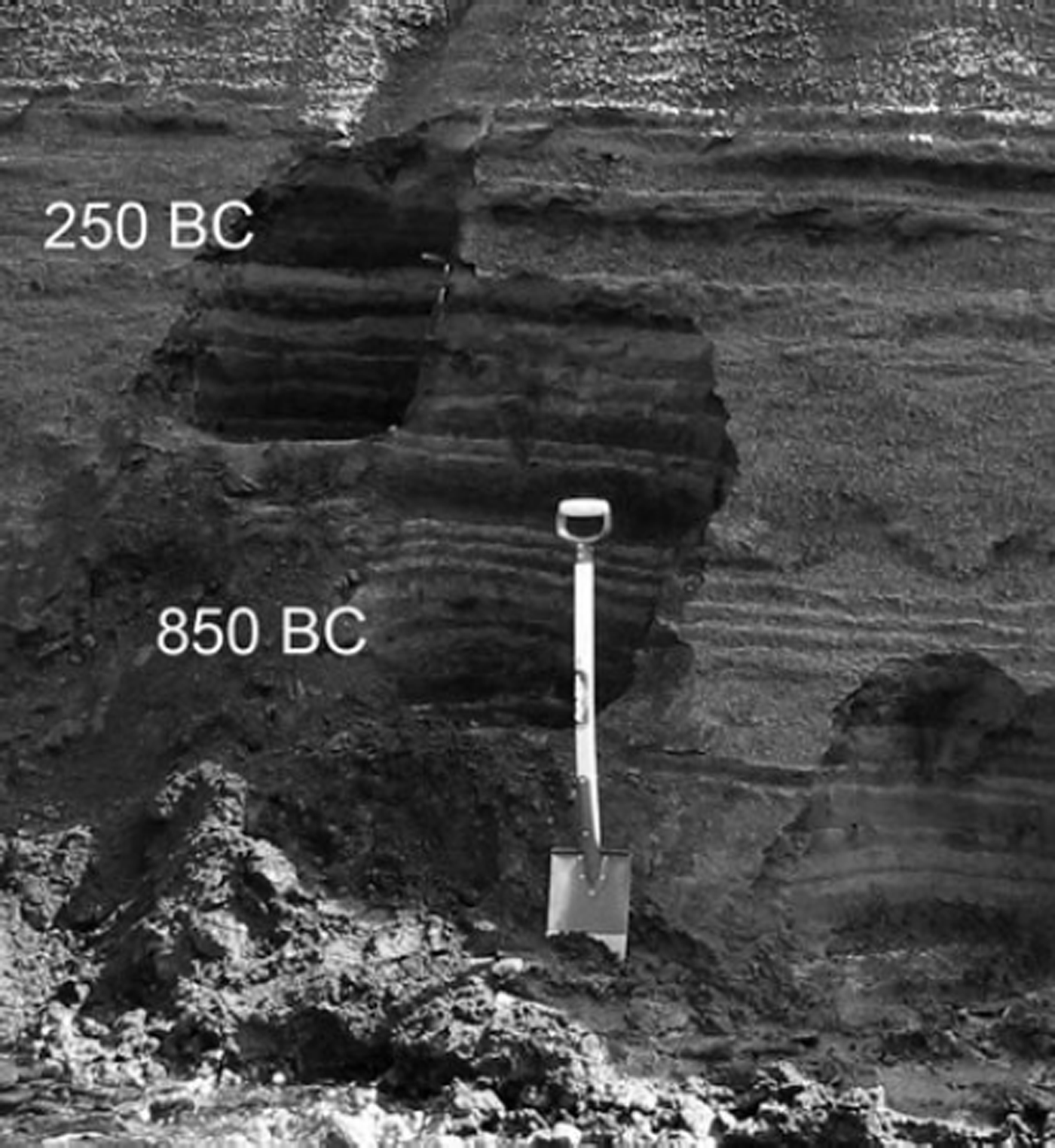
A total of 208 tephra layers were identified in a composite soil section east of the Katla volcano (Fig. 1). They are from 0.1–55 cm thick and separated by soil horizons (Fig. 2). of the 208 identified layers, 182 were inferred to originate from the volcano. of those, 172 are basaltic, 10 are from historic Katla eruptions and 162 are from prehistoric events. of the 208 layers, 126 were analyzed for major element and sulphur concentration giving 111 layers with Katla composition (e.g. Reference Oladottir, Larsen, Thordarson and SigmarssonOladottir and others, 2005) that are the basis of further discussions.
Photograph showing a soil section measured in this study. The shovel is ∽1m in length. The soil horizons separating the individual tephra layers are light grey and the tephra layers are black.
Sample description
The basaltic tephra layers produced by Katla eruptions are brownish black to coal black consisting of poorly to highly vesicular ash- to lapilli-size glass grains. All the Katla tephra samples are composed of light brownish sideromelane glasses and opaque tachylites with 1–15 modal % (94% of the samples have < 5% phenocrysts) and groundmass crystals of plagioclase, olivine, clinopyroxene and rare magnetite. Wall-rock lithics of crystalline basalt, rhyolite and hyaloclastite, as well as crystal fragments of plagioclase and olivine, are present in very small amounts (<1%).
Analytical techniques
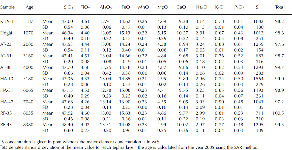
Microprobe analyses were obtained on a WDS Cameca SX 100 at the Laboratoire Magmas et Volcans (LMV), Clermont-Ferrand. The instrument was calibrated on natural and synthetic mineral standards for major elements and sulphur was calibrated using the basaltic glass standard ALV981R23 from a pillow lava rim on the East Pacific Rise (Reference Metrich and ClocchiattiMetrich and Clocchiatti, 1989; Reference Fine and StolperFine and Stolper, 1986). Raw data were corrected by an improved ZAF procedure. During S analyses the accelerating voltage was 15 kV, the beam current 8 nA and the beam diameter 10 mm. The counting time was 50 s on the peak and background. The glass standard, ALV981R23 (Reference Metrich and ClocchiattiMetrich and Clocchiatti, 1989; Reference Fine and StolperFine and Stolper, 1986), was analyzed several times during each microprobe session and all S results are relative to that standard. The analytical error for sulphur is 1.37% (2RSE). Five tephra grains of groundmass glass were analyzed in each tephra layer. Ten representative examples of their mean value and associated standard deviation are given in Table 1.
Major and volatile element concentration in Katla products
Soil accumulation rate (SAR) age model
Seven key marker tephra layers of known age from three volcanic systems, in addition to that of the Katla volcanic system, are distributed throughout the composite soil section. These layers are the basis of a soil accumulation rate (SAR) model used here to determine the age of individual tephra layers in the composite soil section. The mean SAR was obtained for six time periods, each calculated between two known dated tephra layers, and the approximate age of each tephra layer was obtained by interpolation between the dated layers (see Reference Oladottir, Larsen, Thordarson and SigmarssonOladottir and others, 2005, for further details).
Results and Discussion
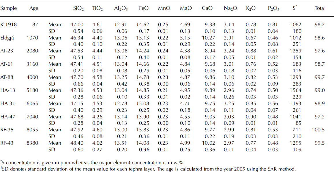
The sulphur concentrations, measured in individual grains from the sampled Katla tephra layers, span the range 466–1811 ppm. A broad range is observed within individual layers with a typical variation of 200–400 ppm and a maximum range of 940 ppm. The mean concentration of individual layers was calculated from five analyses and shows a range of 594–1597 ppm S; the mean S value of the tephra layers is 1180±204 ppm. In Table 1, major and volatile element concentrations for ten representative samples of the whole 8400 year history of Katla activity are shown.
As a general rule, the solubility of sulphur increases with increasing iron concentration given that it is a function of iron content, oxygen and sulphur fugacities (e.g. Reference MathezMathez, 1976; Reference Wallace and CarmichaelWallace and Carmichael, 1992). Hence, Fe-Ti-basalt magmas are characterized by high sulphur concentrations at depth and Katla magmas contain between 2000–2500 ppm of dissolved sulphur prior to eruption (Reference Thordarson, Self, Miller, Larsen, Vilmundardóttir, Oppenheimer, Pyle and BarclayThordarson and others, 2003).
Previous microprobe analyses of sulphur in glass grains from magmatic and phreatomagmatic tephra produced in basaltic fissure eruptions reveal a distinct difference in their S contents (Reference Thordarson, Self, Óskarsson and HulseboeschThordarson and others, 1996, Reference Thordarson, Miller, Larsen, Self and Sigurdsson2001, Reference Thordarson, Self, Miller, Larsen, Vilmundardóttir, Oppenheimer, Pyle and Barclay2003). The magmatic tephra typically contain 300–600 ppm S, which is consistent with the expected sulphur solubility at one atmosphere pressure in basalts, indicating extremely efficient degassing of the magma upon eruption. On the other hand, phreatomagmatic tephra, even from the same eruptions as the magmatic tephra, contain on average significantly more sulphur, ranging from 550–1780 ppm (e.g. Reference Thordarson, Self, Óskarsson and HulseboeschThordarson and others, 1996, Reference Thordarson, Miller, Larsen, Self and Sigurdsson2001). Note that the highest values in the phreatomagmatic tephra approach the sulphur concentration of undegassed magma.
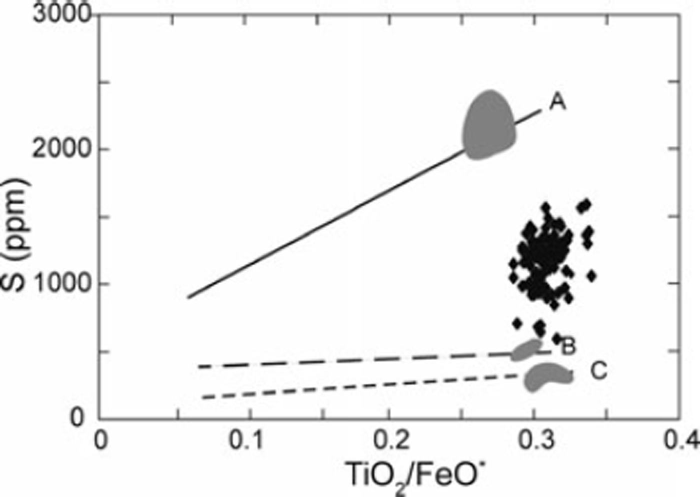
Evidence of a phreatomagmatic origin for the tephra layers in this study are derived from the S versus TiO2/FeO* graph of Thordarson and others (2003; Fig. 3) which is used for evaluating sulphur degassing in basaltic eruptions within the EVZ. The lines A, B and C are best-fit regressions through melt inclusions, magmatic tephra and crystalline lava from three volcanic systems on the EVZ, namely Katla, Grímsvötn and Veiðivötn. Typical values for undegassed Katla magma, fully degassed magmatic tephra and lava, respectively, are shown by the shaded grey areas. The data from this study lie within a tight cluster in the area between the melt inclusions (A) and magmatic tephra (B), i.e. in the area of partially degassed phreatomagmatic magmas. However, six data points with S values 593–711 ppm lie just below the main cluster and approach values indicative of magmatic tephra. One of these samples has a more evolved basaltic composition (i.e. lower in Fe), which may explain the relatively low S concentration. The remaining five samples have typical Fe-Ti basalt composition.
Graph of S versus TiO2/FeO* to evaluate sulphur degassing in basaltic eruptions within the EVZ (after Reference Thordarson, Self, Miller, Larsen, Vilmundardóttir, Oppenheimer, Pyle and BarclayThordarson and others, 2003). Best-fit regression lines for (A) inclusions, (B) magmatic tephra and (C) crystalline lava have been calculated from samples from Grímsvötn, Veiðivötn and Katla; the shaded grey area shows Katla compositions (data from Reference Thordarson, Self, Miller, Larsen, Vilmundardóttir, Oppenheimer, Pyle and BarclayThordarson and others, 2003). Diamonds show analyses from this study: 2-sigma analytical errors are smaller than the symbols.

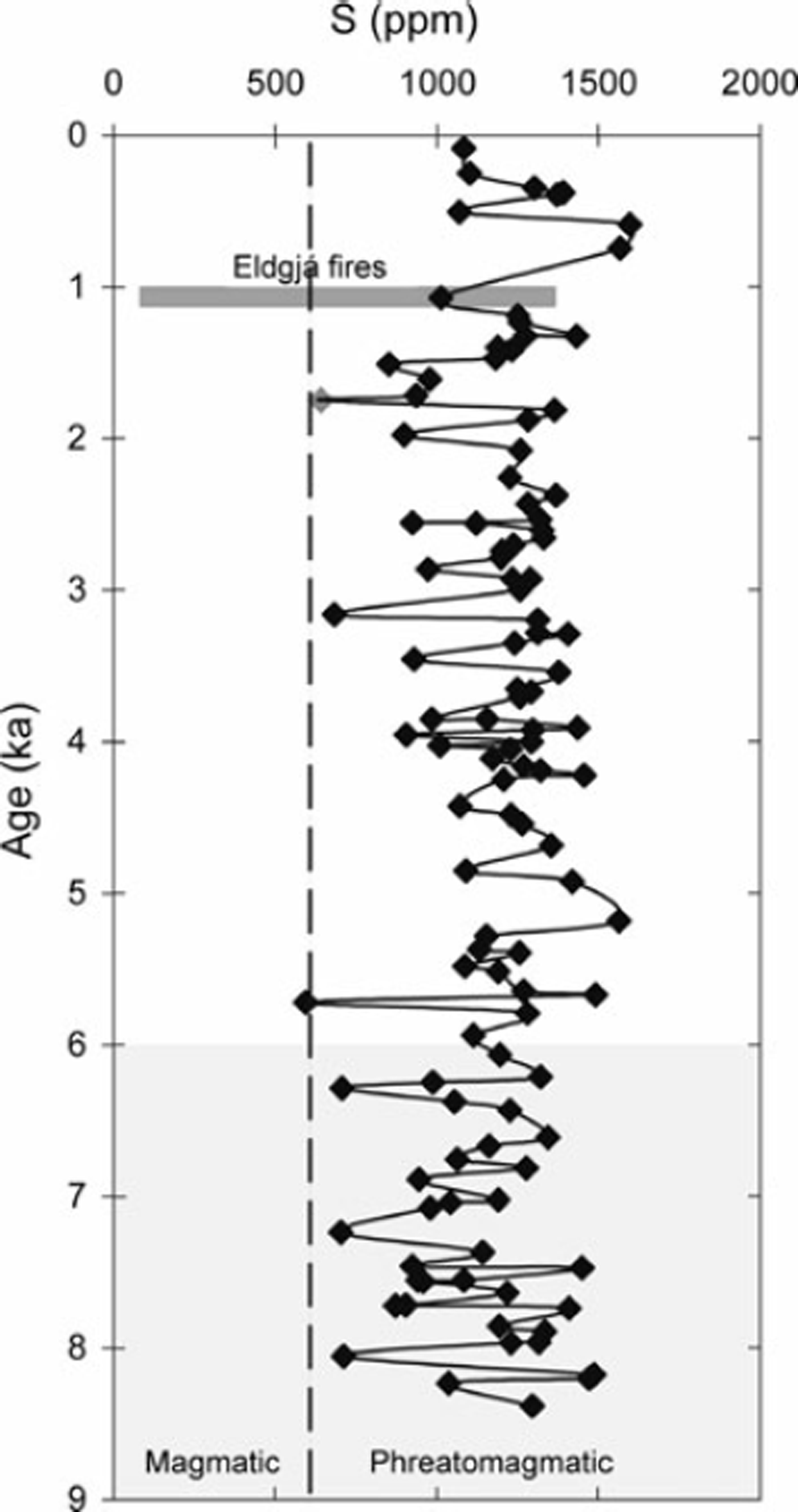
In Figure 4, the mean S concentrations of individual tephra layers are plotted against age, where age was calculated from a SAR model (Reference Oladottir, Larsen, Thordarson and SigmarssonOladottir and others, 2005). The Eldgjá Fires produced tephra with a wide range of S concentrations (85–1360 ppm S; Thordarson, unpublished data), shown with a dark grey line. A fairly irregular distribution was revealed, not indicating any systematic temporal evolution in sulphur. We interpret this pattern to reflect variable degrees of degassing of the measured grains, rather than differences in the amount of degassing between eruptions. The six data points with low S concentrations lie close to the line separating magmatic and phreatomagmatic values. They occur more frequently from ∽8000 to ∽6000 years ago, in accordance with the Holocene thermal maximum proposed by Kaufman and others (2004), but are far from being representative for the period. This might indicate that the Mýrdalsjökull ice cap has been reduced significantly in size by the warmer and drier climate and consequently more magmatic eruptions occurred during this time, although it may not have completely disappeared. However, the fact that the phreatomagmatic eruptions are notably more common throughout the thermal maximum indicates that the Mýrdalsjökull ice cap did not disappear entirely at any time during the last 8400 years. Alternatively, the tephra layers with these low S concentrations may correspond to some of the basaltic fissure eruptions outside the glacier. As the age of those eruptions is unknown, this possibility cannot yet be verified.
Sulphur concentration plotted against age. The vertical broken line shows the value of highest magmatic S concentration (Reference Thordarson, Self, Miller, Larsen, Vilmundardóttir, Oppenheimer, Pyle and BarclayThordarson and others, 2003). The six events showing the lowest S values might represent a significant reduction in the size of the Mýrdalsjökull ice cap during the thermal maximum (indicated by a pale grey shaded area). The grey diamond represents a sample with the most evolved basaltic composition, in which case the low S value is explained by its low Fe value.

The phreatomagmatic eruptive activity that has dominated the last ∽8400 years at Katla indicates that the Mýrdalsjökull glacier has capped the volcano throughout this period. The Holocene climatic optimum in Iceland appears to have occurred between 10 200 and 7000 cal years BP and most likely between 8000 and 6000 cal years BP (Kaufman and others, 2004). Consequently, the Mýrdalsjökull glacier appears to have been present across the climatic optimum, as indicated by our sulphur data. This is also supported by the occurrence of volcanogenic jökulhaups from the Katla volcano between 8000 and 6000 years ago (Reference Smith, Dugmore, Larsen, Vilmundardóttir and HaraldssonSmith and others, 2000; Larson and others, 2005). Thus it is likely that the glacier has been present throughout the Holocene.
However, it is very difficult, if not impossible, to distinguish between phreatomagmatic products created by interaction with water supplied by melting of a glacier or a lake. The topography of the Katla volcano is such that it is possible that the caldera was partly filled by a lake at some stage during the Holocene and the presence of such a lake could also be the cause for the phreatomagmatic eruptions. Nonetheless, the water level of such a crater lake would have been ∽740m a.s.l. at its maximum (based on the bedrock topography; Reference Björnsson, Pálsson and GuðmundssonBjörnsson and others, 2000). The path of the jökulhaups 8000 to 6000 years ago over the highest pass in the caldera wall does not support a crater lake source and is taken to indicate the presence of an ice cap. Consequently, the moderately high and variable sulphur values measured in the phreatomagmatic tephra from Katla are most likely linked to the presence of the Mýrdalsjökull ice cap throughout the Holocene.
Conclusions
Results of S analyses of Katla tephra layers representing the last ∽8400 years show that they were mainly produced in phreatomagmatic eruptions. Six layers show S concentrations close to magmatic values. They occur more frequently from ∽8000 to ∽6000 years ago, which might indicate that the Mýrdalsjökull ice cap was reduced significantly in size during the thermal maximum. Moderately high and variable sulphur values in Holocene tephra layers from Katla indicate persistent phreatomagmatic activity and consequently the presence of water above the eruption sites, either in the form of a glacier or a crater lake. The bedrock topography of the central volcano indicates that a lake could form in the caldera but such a lake cannot be the source of the jökulhaups 8000 to 6000 years ago. Therefore, the phreatomagmatic values observed in the Katla tephra are interpreted here as evidence that the Mýrdalsjökull ice cap has capped the Katla volcano for the last 8400 years and probably longer.
Acknowledgements
This paper is based on a Master-study at the Laboratoire Magmas et Volcans (LMV), CNRS-Université Blaise Pascal in Clermont-Ferrand, financed by the French government through grant No. 20035296. M. Veschambre and J.-L. Devi-dal are thanked for their help with electron microprobe analyses. Support for this work was also provided by the French-Icelandic collaboration programme ‘Jules Verne’ and the Icelandic Science Foundation Rannís, which funded travel costs and microprobe analyses, respectively. Positive reviews of our paper by B. Cameron and J. Dixon are also gratefully Iacknowledged.