INTRODUCTION
Understanding the timing and influence of the mid-Holocene high stand is important for discerning the coastal evolution of the Pacific Islands (Grossmanand Fletcher, 1998), interpreting early human migration and occupation histories (Allen, Reference Allen1998; Rieth et al., Reference Rieth, Morrison and Addison2008; Cochrane et al., Reference Cochrane, Rieth and Dickinson2013), and guiding decision making related to future sea-level rise (Dickinson, Reference Dickinson2003; Goodwin and Grossman, Reference Goodwin and Grossman2003). Holocene sea-level change in the far-field region was initiated by eustatic sea-level rise (Lambeck et al., Reference Lambeck, Esat and Potter2002) associated with the addition of glacial meltwaters and thermal expansion of seawater following the last ice age. In the Northern Hemisphere, melting ended approximately 5000–6000 yr BP (Alley and Clark, Reference Alley and Clark1999) and, assuming no additional meltwater was added to the oceans, Earth continued to deform viscously on time scales of 1000–100,000yr (Conrad, Reference Conrad2013). The solid Earth’s viscous response to deglaciation produced emergent coastal systems in areas formerly occupied by ice sheets and submergent coastal systems in the region of the peripheral forebulge (Mitrovica and Milne, Reference Mitrovica and Milne2002; Conrad, Reference Conrad2013). Far-field locations such as the equatorial Pacific Islands experienced a mid- to late Holocene drawdown in sea level (termed “equatorial ocean syphoning”; Mitrovica and Peltier, 1991) as seawater migrated to the near field and filled growing oceanic basins related to the collapsing forebulge (Mitrovica and Peltier, 1991) and the ocean load induced by levering of continental margins (Mitrovica and Milne, Reference Mitrovica and Milne2002).
The high stand is documented across the equatorial Pacific with peak sea-level values ranging from 0.25 to 3.00 m above present mean sea level (MSL) between 1000 and 5000 yr BP (Fletcher and Jones, Reference Fletcher and Jones1996; Grossman et al., Reference Grossman, Fletcher and Richmond1998; Dickinson, Reference Dickinson2003; Woodroffe et al., Reference Woodroffe, McGregor, Lambeck, Smithers and Fink2012). Woodroffe et al. (Reference Woodroffe, McGregor, Lambeck, Smithers and Fink2012) argues that Holocene sea-level oscillations of a meter or greater are likely to have been produced by local rather than global processes. Thus, the timing and magnitude of the high stand varies between island settings because of localized uplift or subsidence (Dickinson, Reference Dickinson2014) and distance from continental margins (Mitrovica and Milne, Reference Mitrovica and Milne2002). Previous studies estimate mid-Holocene sea level by identifying and dating emergent paleoshoreline features that formed within a restricted elevation range relative to the sea surface (Dickinson, Reference Dickinson2001). Intertidal corals such as microatolls are believed to be the most precise sea-level indicators with an indicative range as low as 3 cm (e.g., Smithers and Woodroffe, Reference Smithers and Woodroffe2000). Beachrock is often used as a paleo–tidal range indicator, and uncertainty can be reduced to half the tidal amplitude if the deposit can be referenced to the upper or lower intertidal zone (Mauz et al., Reference Mauz, Vacchi, Green, Hoffmann and Cooper2015).
Coastal plain sedimentology is often overlooked in mid-Holocene sea-level studies because carbonate sediments alone are not indicative of a precise relationship to former sea level (Goodwin and Grossman, Reference Goodwin and Grossman2003). However, the subsurface sedimentological record of high Pacific Islands is of value because it can be used to infer the geomorphic response and environmental consequences of coastal evolution in response to changes in sea level and local tectonics. Prior research has shown that as sea level falls following a high stand, carbonate sediment is stranded along the coastal plain and later buried by terrigenous sediment as the coastal plain progrades seaward (Calhoun and Fletcher, Reference Calhoun and Fletcher1996). The subsurface carbonate unit thus preserves a record of the landward extent of marine transgression, supplementing prior estimates of high-stand sea level.
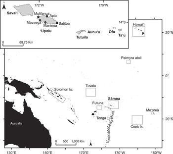
Pacific archaeologists have had a long-standing interest in the effects of sea-level drawdown and environmental habitability along coastal plains as exemplified by analyses at Tikopia, Solomon Islands (Kirch and Yen, Reference Kirch and Yen1982); Manu‘a Islands, Sāmoa (Kirch, Reference Kirch1993); Ha‘apai group, Tonga (Dickinson et al., Reference Dickinson, Burley and Shutler1994); Aitutaki, Cook Islands (Allen, Reference Allen1998); and Mo‘orea (Kahn et al., Reference Kahn, Nickelsen, Stevenson, Porch, Dotte-Sarout, Christensen, May, Athens and Kirch2014). Early in the drawdown phase of the high stand, some coastal landforms may have been less conducive to large populations and productive forms of staple food crops such as wetland taro (Colocasia esculenta) (Kirch, Reference Kirch1983; Spriggs, Reference Spriggs1986; Quintus et al., Reference Quintus, Clark, Day and Schwert2015). Continued sea-level fall, however, eventually led to the expansion of sandy coastal flats characterized by increased size of coastal lowlands, eased coastal access, and low sloped environments more suited to larger human populations (Rieth et al., Reference Rieth, Morrison and Addison2008; Cochrane et al., Reference Cochrane, Kane, Fletcher, Horrocks, Mills, Barbee, Morrison and Tautunu2016). Building on prior archaeological studies, we provide a geologic reconstruction of ‘Upolu, Sāmoa’s (−14°1.2′S, −171°26.0′W; Fig. 1) coastal plain because of the unique potential to assess the impacts of differential subsidence and local variability of sea level across a single island. We define the value below which sea level must fall for a carbonate coast to prograde seaward as the critical value of sea level (Fig. 2A). The critical value initiates a regressive phase of island evolution, enabling the development of coastal landforms for a variety of human uses and settlement.
The central Pacific Island group of Sāmoa consists of three large, high volcanic islands (Savaiʻi, ʻUpolu, and Tutuila) and several smaller islands that are bordered in the southwest by the Tonga-Kermadec trench. Previous sea-level assessments in Sāmoa have focused largely on ʻUpolu Island, whereas the majority of relevant archaeology, paleoclimate, tropical cyclone, and tsunami assessments have been conducted at neighboring Pacific Islands.

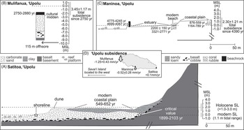
‘Upolu Island coastal stratigraphy interpreted at Mulifanua (after Dickinson and Green, Reference Dickinson and Green1998), Maninoa (after Goodwin and Grossman, Reference Goodwin and Grossman2003), and Satitoa (this study) as a function of Holocene sea-level change and local tectonics. All ages are reported as calendar years before present (cal yr BP). (A) We define the value below which sea level must fall for a carbonate coast to prograde seaward as the critical value of sea level. Following the 1–3 m modeled mid-Holocene high stand, coastal progradation at Satitoa was initiated as sea level fell beneath a critical value of 0.3–1.0 m (approximately 1899–2103 cal yr BP), and the coastal zone switched from a transgressive to a regressive environment. (B) The general stratigraphy at Mulifanua reveals paleobeachrock that formed as beach sands were cemented within the intertidal zone approximately 2750–2880 cal yr BP. The entire unit is now a submerged feature approximately 115 m offshore because of local subsidence (3.45±1.17 m total subsidence). (C) Offshore paleobeachrock formed at Maninoa prior to 4000 cal yr BP and subsided (2.30±1.21 m) to its current position within the modern intertidal zone. The coast prograded 50–100 m in response to a slight lowering in relative sea level between 300 and 700 cal yr BP. (D) Differential subsidence rates were calculated for ‘Upolu based on the elevation and age of beachrock at Mulifanua and Maninoa (Dickinson, Reference Dickinson2007). MSL, mean sea level; SL, sea level.

REGIONAL SETTING
The Sāmoan archipelago consists of three large, high volcanic islands (Savaiʻi, ʻUpolu, and Tutuila) and several smaller islands (Fig. 1) that formed as the Pacific plate moved west over a stationary hot spot. Currently, the hot spot is located beneath Vailuluʻu, a seamount east of Tutuila; however, posterosional volcanism has occurred as recently as AD 1905–1911 on Savaiʻi (Terry et al., Reference Terry, Kostaschuk and Garimella2006). We chose Satitoa village (14°1.73′S, 171°25.96′W), located along the southeastern coast of ʻUpolu, as the focus of this study because modeled subsidence rates are negligible (Dickinson, Reference Dickinson2007), and tropical cyclone and tsunami impacts are well documented in this region (Jaffe et al., Reference Jaffe, Buckley, Richmond, Strotz, Etienne, Clark, Watt, Gelfenbaum and Goff2011; McAdoo et al., Reference McAdoo, Ah-Leong, Bell, Ifopo, Ward, Lovell and Skelton2011; Richmond et al., Reference Richmond, Buckley, Etienne, Chagué-Goff, Clark, Goff, Dominey-Howes and Strotz2011).
Satitoa is characterized by a relatively broad coastal plain (up to 300 m in width) bordered on one end by a gradually ascending alluvial slope and on the other by a wide, shallow (<~5 m) fringing reef (Richmond et al., Reference Richmond, Buckley, Etienne, Chagué-Goff, Clark, Goff, Dominey-Howes and Strotz2011; Supplementary Fig. 1). The eastern and southern coasts of ʽUpolu are characterized by regionally thicker coastal deposits because of exposure to the dominant southeasterly trade winds, well-developed and sediment-rich fringing reef complexes, and relatively high wave energy (typical 1.3–2 m wave heights may exceed 10 m during severe cyclones) (Richmond et al., Reference Richmond, Buckley, Etienne, Chagué-Goff, Clark, Goff, Dominey-Howes and Strotz2011). A rock revetment protects the coastal Satitoa community and prevents the formation of a modern beach.
Subsurface stratigraphy of the carbonate plain
Two studies on the island of ʻUpolu, Sāmoa, focused on the post–mid-Holocene high-stand sedimentary sequence. Mulifanua (northwestern ʻUpolu; Fig. 2B), the oldest known Sāmoan settlement site (2880–2750 cal yr BP), was discovered submerged approximately 115 m offshore (Dickinson and Green, Reference Dickinson and Green1998; Petchey, Reference Petchey2001). A cultural midden layer was deposited on a thick (4.58 m thick) sandy beach that originally lay above sea level during the high stand. Following the high stand, local subsidence outpaced sea-level fall, and the surface of the beach became cemented into beachrock within the intertidal zone. Beachrock (0.75 m thick) currently extends up to the modern lagoon floor, preserving the underlying carbonate sand and cultural midden unit.
Building on the work of Dickinson and Green (Reference Dickinson and Green1998), Goodwin and Grossman (Reference Goodwin and Grossman2003) analyzed coastal sedimentology along a shore perpendicular transect at Maninoa, southern ʻUpolu (Fig. 2C). Offshore, stranded beachrock is interpreted as a former carbonate beach that formed around the time of the mid-Holocene high stand (4699-4067 cal yr BP) (Goodwin and Grossman, Reference Goodwin and Grossman2003). Because the offshore beachrock is not emergent and instead is located within the modern intertidal zone, the authors concluded that southern ʻUpolu subsided since the high stand. In addition, the region is believed to have experienced expansive coastal plain progradation (50–100 m) between approximately 300 and 1000 cal yr BP in response to a slight lowering in relative sea level (Goodwin and Grossman, Reference Goodwin and Grossman2003).
Vertical shifts in island elevation
Accounting for vertical shifts in island elevation in response to local or regional tectonism is necessary to accurately reconstruct paleo–sea level (Dickinson, Reference Dickinson2001). Over time, shorelines may be vertically displaced because of a volcanic load creating lithospheric flexure (Pirazzoli and Montaggioni, Reference Pirazzoli and Montaggioni1988; Muhs and Szabo, Reference Muhs and Szabo1994). For example, subsidence rates of the island of ‘Upolu (Mulifanua and Maninoa) (Fig. 1) were reestimated (Eq. 1) by Dickinson (Reference Dickinson2007) based on the elevation and age of beachrock (interpreted as a paleoshoreline indicator) at each site and a correction for ice age sea-level change (Mitrovica and Peltier, 1991) across each respective time period.
 $$\eqalignno{&{\rm Subsidence}\,{\rm rate}\left( {{{{\rm mm}} \over {{\rm yr}}}} \right) \cr& {\,\equals\,}{{{\rm Elevation}\,{\rm of}\,{\rm dated}\,{\rm beachrock}\,({\rm mm}){\plus}{\rm Sea{\hbox-}level}({\rm mm})} \over {{\rm Age}\,({\rm yr}\,{\rm BP})}} \cr& $$
However, Dickinson (Reference Dickinson2007) underestimated the uncertainty associated with subsidence because his analysis only accounted for the 14C error associated with the dated material and ignored the vertical error associated with beachrock formation. In the absence of cement and facies analysis, beachrock error can be approximated by the local tidal range (Mauz et al., Reference Mauz, Vacchi, Green, Hoffmann and Cooper2015). Dickinson’s (Reference Dickinson2007) subsidence estimates were updated in this study by incorporating the median tidal range value of 1.1 m observed at Apia, ‘Upolu (Goodwin and Grossman, Reference Goodwin and Grossman2003), into the uncertainty analysis. Mulifanua was modeled to be subsiding at 1.25±0.43 mm/yr, and Maninoa, located approximately 30 km from Mulifanua, was modeled as subsiding at 0.52±0.28 mm/yr (Fig. 2D). Subsidence rates at Mulifanua and Maninoa were compared with the modeled pattern of flexural subsidence known for Hawaiʻi (Moore et al., Reference Moore, Ingram, Ludwig and Clague1996), and it was concluded that differential subsidence related to distance from the central volcanic load at Savaiʻi was a viable option for explaining the local sea-level history. Furthermore, the model implies that the lowest subsidence (<0.1 mm/yr) rates would be found on the far eastern end of ʻUpolu.
The role of tsunamis and storms in reworking coastal plain sediments
The tropical Pacific is characterized by a high frequency of tropical cyclones and tsunamis. Although distinguishing amongst tsunami and storm deposits is a growing field, it was not the purpose of this study, and rather we acknowledge that both events are mechanisms of carbonate deposition and erosion within the subsurface coastal plain. The historical record of storms and tsunamis should be investigated so that correlations between the sedimentological record and these catastrophic saltwater events may be made or ruled out. For example, in the region surrounding ʻlthou, Sāmoa, five tsunamis with a maximum water height of 3 m or greater (Richmond et al., Reference Richmond, Buckley, Etienne, Chagué-Goff, Clark, Goff, Dominey-Howes and Strotz2011) and eight category 2 cyclones or greater have been documented since 1868 (Diamond et al. Reference Diamond, Lorrey, Knapp and Levinson2011; Supplementary Table 1). In both Sāmoa and Tuvalu (Fig. 1), cyclone banks as large as 2–3 m high, 50 m wide, and 2 km long formed by large storm waves that dredged coral debris from the fore reef and reef crest and deposited them as far as 10–20 m shoreward onto the reef flat (Rearic, Reference Rearic1990) where they were reworked and moved shoreward by subsequent wave action. In addition, both tsunamis and storm waves can transport and deposit coral boulders along the coastal plain (Goto et al., Reference Goto, Miyagi, Kawamata and Imamura2010; McAdoo et al., Reference McAdoo, Ah-Leong, Bell, Ifopo, Ward, Lovell and Skelton2011; Richmond et al., Reference Richmond, Buckley, Etienne, Chagué-Goff, Clark, Goff, Dominey-Howes and Strotz2011).
Because Holocene sea-level studies typically extend beyond the historical record, an understanding of the potential for paleotsunamis and paleostorms is pertinent for interpretation of coastal stratigraphy. A recent study at Futuna Island (~600 km west of Sāmoa; Fig. 1) identified two Holocene paleotsunamis believed to have originated from the Tonga-Kermadec trench region (Fig. 1) around 1860–2000 cal yr BP and 470 cal yr BP (Goff et al., Reference Goff, Lamarche, Pelletier, Chagué-Goff and Strotz2011). In addition, fossil corals provide high-resolution reconstructions of tropical Pacific climate, and a 1100 yr δ18O monthly resolved coral record from Palmyra Atoll (Fig. 1) reveals significant changes in El Niño–Southern Oscillation (Cobb et al., Reference Cobb, Charles, Cheng and Edwards2003), indicative of a highly variable tropical Pacific climate throughout the late Holocene (Mayewski et al., Reference Mayewski, Rohling, Curtstager, Karlén, Maasch, Davidmeeker, Meyerson, Gasse, Vankreveld and Holmgren2004). Time periods characterized by “El Niño–like conditions” generally have an increased probability for extreme weather events such as tropical cyclones for island countries within the South Pacific region (Cai et al., Reference Cai, Lengaigne, Borlace, Collins, Cowan, McPhaden and Timmermann2012).
METHODS
Cores (sample collection)
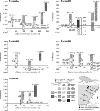
Eighteen cores were sampled along five shore perpendicular transects (labeled A–E; Fig. 3) to record the spatial coverage, composition, and age of the subsurface carbonate unit. A T-handle bucket auger recovered successive units of sediment until refusal, typically at depths of 1 to 2 m. Field descriptions such as texture, depth of sediment horizons, and the presence of datable coral clasts were recorded at each core location. Two surface grab samples were recovered from the Satitoa reef flat and the modern beach face at Taufua beach (~2.20 km to the southwest). This project was completed in conjunction with an archaeological study that excavated four test pits next to the geologically focused auger cores (Cochrane et al., 2016).
Stratigraphic cross sections of 18 cores depicting dominant sedimentological units, location of carbonate clasts, and calibrated age ranges (cal yr BP) of dated material at Satitoa, eastern ‘Upolu. Elevation is referenced to mean sea level, and distance from the modern shoreline is based on the mapped position of the low water mark during the time of data collection. Calibrated age ranges are reported at the 95.4% (2σ) confidence interval. In general, the stratigraphy of the coastal plain consists of a carbonate sand layer overlain by a loam. The coastal plain transitions into a terrigenous unit at the furthest inland extent of the study area.

Topographic data
A digital elevation model (DEM) of the study area was created from topographic point data collected with a Leica TS12 robotic total station on September 2–7, 2014. The reference survey points were adjusted to geographic coordinates and ellipsoid heights relative to World Geodetic System 1984 using an Ashtech LOCUS survey grade integrated L1 global positioning system receiver/antennae base station. Because the tidal relationship between the Satitoa village study site and the Apia tide gauge is not established, the surveyed elevations were referenced to local low water observed at the toe of the Satitoa shoreline. Low water positions were adjusted to MSL using the average low tide recorded at the Apia tide station on the days that topographic data were collected (http://www.ioc-sealevelmonitoring.org/). A triangular irregular network was derived from the topographic point data and interpolated into a DEM using the nearest neighbor method.
Sedimentology, age, and composition of the coastal plain
Similar to Harney et al. (Reference Harney, Grossman, Richmond and Fletcher2000), carbonate sand samples were sieved through eight grain-size classes according to the Wentworth (Reference Wentworth1922) scale, and mean grain size and sorting index were calculated using Folk and Ward (Reference Folk and Ward1957). Coral clasts and two surface sediment samples were submitted to the National Ocean Sciences Accelerator Mass Spectrometry Facility at Woods Hole Oceanographic Institution for 14C radiocarbon dating. Coral clasts selected for dating had uniform characteristics: minimal recrystallization, spatial representation of the study area, and constrained at the top and base of the cored carbonate layer. Coral clasts were pretreated for dating with ultrasonic washing and acid etching, and radiocarbon ages were corrected for the regional marine reservoir effect using CALIB version 7.1 and the Marine13 calibration data set (Stuiver and Braziunas, Reference Stuiver and Braziunas1993; Reimer et al., Reference Reimer, Bard, Bayliss, Beck, Blackwell, Bronk Ramsey and Buck2013; http://calib.qub.ac.uk/calib/calib.html).
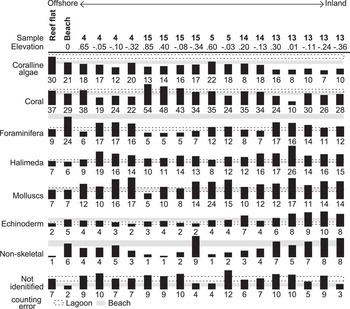
A compositional analysis of the carbonate sand layer was performed to determine the origin and relative percentage of skeletal, nonskeletal, and unidentifiable grains (Harney et al., Reference Harney, Grossman, Richmond and Fletcher2000). Skeletal grains included coral, coralline algae, Halimeda, mollusc, benthic foraminifera, and echinoderm fragments. Nonskeletal sediment includes intraclasts and crystalline/volcanic grains. Carbonate sediments were embedded in epoxy and thin sectioned, and a petrographic microscope was used to classify a minimum of 300 identifiable grains for cores 4, 5, 13, 14, 15, and the surface sediment samples collected at the reef flat and beach.
RESULTS
In general, the stratigraphy of the coastal plain reveals an abrupt contact between the surface loam and underlying carbonate sand (Fig. 3). Carbonate sand extends inland as far as 200 m and is typically found between 1.34 m and –0.71 m relative to MSL. Thickness varies from 0.58 m to 1.80 m; however, because of difficulty in coring, most cores were not able to fully penetrate the sandy carbonate unit. The basal carbonate units typically did not contain rip-up clasts, included both intact and fragmented marine shells, and were thicker (0.48–1.51 m) than both the modern tsunami deposits recorded at ‘Upolu and paleostunami deposits of Futuna Island. Three cores (3, 9, and 10) encountered a second carbonate layer (<25 cm thick) at the surface of the core, which may be interpreted as a deposit of the 2009 South Pacific tsunami. The landward cores of each transect are typically composed entirely of loam or clay, with the exception of transect D, which is bordered on the landward extent by a thickly vegetated marsh. Surface sand content diminishes in the south (transect E), and cores are capped with clay loam.
The subsurface carbonate unit generally fines upward (66.7% of cores) and contains poorly to very poorly sorted, coarse to very coarse sand at the base. The seaward cores (9 and 10) and core 17 are an exception. Cores 9 and 10 contain a massive medium sand layer that is moderately well to poorly sorted, and core 17 fines upward with the exception of a very poorly sorted medium sand layer at the base of the core. Cores 3, 9, and 10 have a second carbonate sand unit at the surface that is characterized by moderately well to poorly sorted, fine to medium sand. Modern beach and reef flat sediment samples are characterized by coarse sand that is moderately well and poorly sorted, respectively.
Cored sands contained isolated coral clasts, marine shells (Monetaria moneta), and carbonate concretions. The subsurface carbonate unit was dominated by skeletal grains, with unidentifiable grains accounting for 2%–12% of total composition (Fig. 4). Coral and coralline algae derived from the reef framework are the dominant sources of sediment, representing ≤42.0% of total composition. Core 13 was found to have a lower relative percentage of reef-derived components and a higher combined percentage of in situ calcareous organisms such as benthic foraminifera, Halimeda, molluscs, and echinoderms.
Relative percentage of reef-derived skeletal sediment, nonskeletal sediment, and unidentifiable materials (origin could not be determined). Surface samples were collected within the reef flat and Taufua beach, and subsurface carbonate samples were obtained from cores 4, 5, 13, 14, and 15.

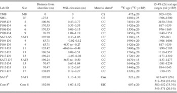
All calibrated 14C ages presented in Table 1 may be referenced with respect to distance from the shoreline and elevation relative to MSL. Core 5 (3150–3346 cal yr BP) and core 9 (1949–2151calyrBP) contain the two oldest dates and are found near the surface of the carbonate layer and relatively close to the modern shoreline. There is a general trend of increasing age with depth for those samples collected 150–200 m from the modern shoreline. The remaining coral clasts and surface sediment samples cluster around 838–1518 cal yr BP; however, these samples do not depict a relationship with depth or distance from shoreline. Because the base of the carbonate unit was not penetrated, reported ages of basal sediments may underestimate the initiation of coastal progradation.
Radiocarbon dates of cored material.

a Material dated: CC, coral clast; Cnn, Cocos nucifera nutshell; CS, carbonate sand; UIC, unidentified charcoal.
b Samples SAT1 (1.13–1.30 m depth) and Core 8 were originally published in Cochrane et al. (2016) and were found in a cultural loam layer that sits on the subsurface carbonate unit.
DISCUSSION
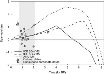
Numerous studies throughout the central Pacific equatorial region provide evidence of emergent shorelines formed by the mid-Holocene high stand (Calhoun and Fletcher, Reference Calhoun and Fletcher1996; Fletcher and Jones, Reference Fletcher and Jones1996; Allen, Reference Allen1998; Grossman et al., Reference Grossman, Fletcher and Richmond1998; Dickinson, Reference Dickinson2001), yet coastal plain sedimentology is often overlooked because coral clasts and sands are not indicative of a precise relationship to former sea level (Goodwin and Grossman, Reference Goodwin and Grossman2003). The true value of the subsurface carbonate unit is that it records the landward extent of marine transgression, and when correlated with time using modeled sea-level curves, we can determine a timeline for shoreline regression. For example, at Satitoa the coastal plain prograded seaward approximately 200 m beginning as early as 2000calyrBP. Holocene sea-level curves for ʻUpolu (Fig. 5) were computed using a theory of ice age sea-level change (Alley and Clark, Reference Alley and Clark1999) that incorporates the full deformational, gravitational, and rotational perturbations to the Earth system driven by ice melt and ocean meltwater loading (Kendall et al., Reference Kendall, Mitrovica and Milne2005). The calculations require, on input, models for the ice history across the last glacial cycle and the depth variation of viscosity within the Earth model. The following published pairings of ice history and mantle viscosity were adopted: the ICE 5G ice history and VM2 viscosity model (Peltier and Fairbanks, Reference Peltier and Fairbanks2006), the ICE 6G ice history and VM5 viscosity model (Argus et al., Reference Argus, Peltier, Drummond and Moore2014), and the ice history described by Lambeck et al. (Reference Lambeck, Rouby, Purcell, Sun and Sambridge2014), which is referred to as ANU, together with the viscosity model favored in their analysis (henceforth, the “LM” model). Variations in modeled ice history and viscosity affect the timing and amplitude of the high stand. For example, the viscosity models VM2 and VM5 are characterized by a relatively weak lower mantle (<3×10²¹Pas), significantly lower than the value in model LM (2×10²²Pas). Thus, coupling the sedimentary record with the modeled sea-level curves does not confirm the accuracy of the geophysical record, but rather we can conclude that coastal progradation at Satitoa occurred nearly two to four millennia after the mid-Holocene high stand. As sea level fell below a critical sea-level value of 0.3–1.0 m, the rate of deposition of marine sediments exceeded the rate of erosion along the coast.
Dated core material is plotted together with three Holocene sea-level curves computed using the coupled ice history and mantle viscosity models: ICE 5G-VM2, ICE 6G-VM5, and ANU-LM (see text). Cultural dates were obtained from the sandy loam cultural layer described by Cochrane et al. (2015), and all other dates originate from subsurface coral clasts or surface carbonate sand. The sedimentary record is plotted here with the modeled sea-level curves not to confirm the accuracy of the modeled sea-level record or to reconstruct Holocene shoreline migration, but rather to constrain a time period for the initiation and growth of the sandy coastal plain. Coastal plain progradation initiated 1899–2103calyrBP and continued until approximately 549–652calyrBP when the unit became buried by the cultural loam layer. Because the base of the carbonate unit was not dated, the reported dates may represent a minimum age for coastal progradation.

An understanding of the vertical shifts in island elevation in response to local or regional tectonism is necessary to accurately account for the magnitude of sea-level change, as well as the timing of subsequent coastal evolution. We argue that differential subsidence rates at ʻUpolu result not only in variations of relative sea level but also the timing at which the coastal plain recovers from an erosive state and begins to prograde seaward. Expansive coastal plain progradation has also been observed along the southern coast of ʻUpolu but occurred later between 300 and 1000calyrBP and is originally believed to have been linked to increased sediment production and coral growth in response to a slight relative lowering of sea level (Goodwin and Grossman, Reference Goodwin and Grossman2003). Thus, a lag in seaward growth along the southern coast may be related to higher relative sea level because of greater subsidence rates with closer proximity to the volcanic load on Savaiʻi Island (Fig. 2D).
Improving the interpretation of coastal plain evolution
Based on the age of carbonate clasts and presence of date inversions, we conclude that the subsurface carbonate architecture was heavily influenced by periodic, high-energy events such as tsunamis and cyclones. Prior high-intensity events are known to remove and transport large sediment loads (silt size to coral boulders) from the reef crest to the beach and coastal plain (McAdoo et al., Reference McAdoo, Ah-Leong, Bell, Ifopo, Ward, Lovell and Skelton2011; Richmond et al., Reference Richmond, Buckley, Etienne, Chagué-Goff, Clark, Goff, Dominey-Howes and Strotz2011). We acknowledge periodic redeposition by high-energy events as a research problem and call on the importance of analyzing both the instrumental record and geologic record of tsunami and tropical cyclones when interpreting the stratigraphic record of Pacific Islands. For example, the 1860–2000 cal yr BP paleotsunami recorded at nearby Futuna Island could have eroded and deposited sediment at the base of our carbonate unit, and the younger 470 cal yr BP event could have reworked sediment near the surface. High-energy punctuated events could also be responsible for our two oldest dates, which we interpret as outliers. Core 9 (1949–2151calyrBP) represents the closest core to the present marine environment, and core 5 (3150–3346 cal yr BP) is at least 1000 yr older than any other dated material.
Dated bulk surface sediments from the beach and reef flat suggest that coastal sand-sized sediment may remain in transport for approximately 900–1500yr, which is not uncommon for the Pacific Islands (Moberly and Chamberlain, Reference Moberly and Chamberlain1964; Harney et al., Reference Harney, Grossman, Richmond and Fletcher2000; Resig, Reference Resig2004). In bioclast-rich environments, there is inherently a temporal uncertainty associated with radiocarbon ages because beach sediment originates from the progressive destruction of reef framework limestone and calcifying organisms. In future experiments, the age of the coastal plain can be constrained more accurately by dating individual, delicate or spiny foraminifera such as Calcarina and Baculogypsina spaerulata as the ages of these specimens are more reflective of deposition and burial soon after death (Kayanne et al., Reference Kayanne, Yasukochi, Yamaguchi, Yamano and Yoneda2011; Ford and Kench, Reference Ford and Kench2012).
The Holocene sea-level models incorporated in this study assume lateral uniformity in mantle viscosity, and as a result, continental margins and midocean environments are described by the same mantle rheology parameters. We acknowledge this as a flaw in the current state of these models because of the limited distribution of island data and the poor resolution of depth dependence of viscosity for islands (Lambeck et al., Reference Lambeck, Rouby, Purcell, Sun and Sambridge2014). Following conventional practice, we attempt to account for uncertainty by employing a suite of the most widely accepted ice history and viscosity models (Peltier and Fairbanks, Reference Peltier and Fairbanks2006; Toscano et al., 2011; Argus et al., Reference Argus, Peltier, Drummond and Moore2014; Lambeck et al., Reference Lambeck, Rouby, Purcell, Sun and Sambridge2014), thus producing a range of predicted sea-level values that encompass both the Holocene high stand and the subsequent fall in sea level. Coupling the sedimentary record with the modeled sea-level curves does not confirm the accuracy of the modeled sea-level record but rather constrains a time period for the initiation and growth of the sandy coastal plain. Interpreting the shape of the sea-level curves is imperative to interpreting coastal plain evolution. The slopes of the three curves are comparable for the period of sea-level drawdown, resulting in a similar rate (0.8–0.9 mm/yr) of sea-level fall. The LM model implies that coastal progradation started when the sea level was approximately 0.5 m higher than the other two curves.
Implications of coastal evolution on past and future societies
Coastal plain evolution is of particular interest to the permanent settlement and migrations of the first Pacific Island peoples because no single factor has influenced coastal environments more than sea-level fluctuations (Allen, Reference Allen1998). Prior studies have argued that because of the low gradient of most coastal plain environments, the rate of future sea-level rise impact will rapidly accelerate once the height of the sea surface exceeds a critical elevation (Kane et al., Reference Kane, Fletcher, Frazer and Barbee2015). Using this same logic, we reason that habitable coastal environments may not evolve until the sea level falls below a critical value that allows for the rapid development of suitable coastal flats. For example, at the nearby Sāmoan islands of Tutuila and Aunuʻu it has been argued that permanent settlement prior to approximately 2500 cal yr BP was limited because of the lack of suitable sandy coastal flats related to less settlement space, coastal access, and higher slope under elevated sea level (+2.0 m) (Rieth et al., Reference Rieth, Morrison and Addison2008). A cultural layer with sparse anthropogenic deposits found directly on top of the carbonate sands at Satitoa, ʻUpolu, was dated and provides a terminus ante quem of 549–652 cal yr BP for the marine carbonate unit (Cochrane et al., Reference Cochrane, Kane, Fletcher, Horrocks, Mills, Barbee, Morrison and Tautunu2016). Thus, it is not until ~500 cal yr BP (Cochrane et al., Reference Cochrane, Kane, Fletcher, Horrocks, Mills, Barbee, Morrison and Tautunu2016), more than a millennium after coastal progradation began, that the coastal zone stabilized and anthropogenic deposits indicative of a small population along eastern ʻUpolu appear. Our findings support previous studies that suggest that post–mid-Holocene drawdown in regional sea level produced coastal settings that were morphologically attractive for human settlement (Dickinson, Reference Dickinson2001; Rieth et al., Reference Rieth, Morrison and Addison2008; Cochrane et al., Reference Cochrane, Rieth and Dickinson2013; Burley and Addison, Reference Burley and Addison2015).
A better understanding of coastal plain evolution since the fall of the mid-Holocene sea-level high stand may guide decisions related to coastal communities affected by future sea-level rise. The Intergovernmental Panel on Climate Change Fifth Assessment Report predicts by the end of the century, under a worst case scenario (RCP8.5), that equatorial Pacific regions may experience sea-level values 10%–20% above the global mean of 0.74±0.23 m (Church et al., Reference Church, Clark, Cazenave, Gregory, Jevrejeva, Levermann and Merrifield2013). Coastal plain evolution recorded in the sedimentary record of volcanic islands reveals the timing and extent of marine transgression as Holocene sea level approached values similar to future projections. In addition, model projections also forecast increased South Pacific Convergence Zone migration and increased extreme El Niño and La Niña events in response to global warming (Cai et al., Reference Cai, Lengaigne, Borlace, Collins, Cowan, McPhaden and Timmermann2012, Reference Cai, Borlace, Lengaigne, van Rensch, Collins, Vecchi and Timmermann2014, Reference Cai, Wang, Santoso, McPhaden, Wu, Jin and Timmermann2015). Thus, overlaid on the long-term rise in sea level may be periods of increased probability for extreme weather events such as tropical cyclones. The impacts of short-term catastrophic events such as storms and tsunamis will be further exacerbated by future sea-level rise.
CONCLUSION
Coastal plain stratigraphy is often overlooked in paleo–sea-level reconstructions because carbonate sediments do not precisely constrain former sea level. Here we show that Pacific Island sedimentology provides an invaluable record of geomorphic and environmental consequences of coastal evolution in response to changes in sea level and local tectonics. Coastal evolution in response to prior changes in sea level is of particular interest because the late Holocene fall in sea level is believed to have played a dominant role in the availability of suitable coastal habitats where early human populations were typically found. A series of auger cores obtained from eastern ‘Upolu reveal that as sea level falls following a high stand, carbonate sediment derived from the destruction of the offshore reef framework is stranded along the coastal plain and subjected to periodic erosion and redeposition by punctuated high-energy events such as tsunamis and tropical cyclones. When interpreting coastal sediments, it is important to have some understanding of the historical context of the timing and impacts of tropical cyclones and tsunamis so that uncertainties related to interpretations of the sedimentological record may be reduced. In addition, to accurately reconstruct the magnitude of relative sea level and the timing of coastal progradation across larger volcanic islands, it is necessary to account for vertical shifts in island elevation in response to local or regional tectonism. For example, we show that a lag in seaward growth along the southern coast of ʻUpolu may be related to higher relative sea-level rates resulting from increased subsidence rates closer to the volcanic load on Savaiʻi.
Coupling the sedimentological record with geophysical models of mid- to late Holocene sea level, we identify a critical value (0.3–1.0 m) during the falling phase of the sea-level high stand (1899–2103 cal yr BP) that represents the transition from a transgressive to a regressive environment and initiates coastal progradation. By correlating the critical value with time, we observe that nearly a millennium of coastal plain development is further required before a small population is established. The framework by which a critical value of sea level may be used to better constrain the timing and development of morphologically attractive coastal settings for human settlement is relevant throughout the far-field Pacific as the mid-Holocene sea-level high stand was a regionally prominent geophysical event that shaped the coastal plain of thousands of islands. Thus, we conclude that as sea level rises into the future, approaching mid-Holocene high-stand values, lessons learned from the Pacific Island sedimentological record may be useful in guiding future decisions related to coastal processes and habitat suitability. Future sea-level rise will once again exceed a critical value, and the rate and extent of flooding will rapidly accelerate across the coastal plain. By coupling future sea-level rise models with local topography, decision makers may begin to develop a timeframe by which they may plan for the largest impacts of sea-level rise.
ACKNOWLEDGMENTS
Mahalo e Satitoa village, Matiu Matavai Tautunu, Joseph Mills, Alexander Morrison, and Ralph Moberly. Funding provided by the School of Ocean and Earth Science and Technology, Pacific Islands Climate Change Education Partnership, Pacific Islands Climate Science Center, and the University of Auckland Faculty of Arts Research Development Fund.
Supplementary material
For supplementary material/s referred to in this article, please visit http://dx.doi.org/10.1017/qua.2017.2