


Introduction
The Indian government has embarked upon an ambitious programme to transform the ‘idyllic’ waterscapes of the river Brahmaputra and its tributaries into the nation's future powerhouse. Behind this grand ambition lies a troubled relationship between the Indian nation-state and the country's rivers.Footnote 1 The anxiety inherent in this relationship is reflected by attempts to construct embankments and canals in previous centuries. In the nineteenth century, the British colonial government invested massively in flood control and canal construction, for instance, in eastern and northern India. A central aim of these works was to ensure property rights in permanently settled areas and to stabilize the government's revenues. In contrast, no major river training work was undertaken in the Brahmaputra's floodplains until the middle of the twentieth century. The valley was not unfamiliar to the empire: its grand capitalist investments in Assam and the re-ordering of its natural resources—tea plantations, timber, and the petroleum industry—had already proved profitable in the nineteenth century.Footnote 2 Tea plantations were not greatly threatened by flooding because they were located chiefly in the valley's highlands. As these grand designs unfolded, the river acted as the main artery for the circulation of humans and commodities.
Flood protection in the Brahmaputra's floodplains began rather late and was implemented to protect the important commercial crop of jute. To begin with, early in the twentieth century, after a long wait and a great deal of speculation, it was time to take action to make the Brahmaputra's floodplains more productive to the British empire. Soon the commercial production of jute in the floodplains began. As jute cultivation expanded, over several decades millions of smallholding peasants arrived in the floodplains of the valley from the neighbouring areas of East Bengal. By the third decade of the twentieth century, the valley emerged as South Asia's main jute-growing area. Jute was principally a flood season crop. As more low-lying areas were reclaimed and the acreage under jute cultivation expanded, the need to protect the jute crops of the smallholding raiyatwari Footnote 3 farmers from floods became urgent. With this aim in mind, after the 1940s the government built a network of embankments. Embankments transformed the nature of the rivers and their relation with the floodplains, and thereby ensured the separation of water from land.
Literature examining how imperialism unfolded in Assam reveals little about the ecological transformation of the Brahmaputra's floodplains in the twentieth century. This article, by examining the interconnected stories of jute and the floodplains, argues that flood control in the valley began mainly as a means to protect this cash crop and expand agriculture in the low-lying areas. Flood management also safeguarded the interests of capital. The Brahmaputra valley was not the only region where flood protection measures were implemented for such reasons. In the twentieth century, various governments in different parts of the world undertook grand flood control projects to expand agriculture into low-lying areas.Footnote 4 This article also explores how the Indian government's ambitious river valley projects, seemingly aimed at improving the valley, represent a fundamental shift in the Indian state's perspective on rivers and agrarian environments. This ambition demonstrates not only the techno-economic strength of the modern stateFootnote 5 but is also symptomatic of the evolving character of the Indian state and its attitude towards India's natural resources.Footnote 6 The article explores how the ecological profiles of the river and the floodplains were more dynamic than the human understanding of the floodplains. This incongruity acted as a major hindrance behind the repeated failure of the government to keep its promises. The failure to engage with this historical experiences, resulting in the undertaking of hydropower projects only reinforces James C. Scott's powerful argument that bureaucratic institutions ‘can never adequately represent the complexity of natural or social processes’.Footnote 7
The first section of this article explains how the Brahmaputra's floodplains were converted into the British empire's eastern-most jute frontier. The second section explains the political economy of flood management in Assam in the second half of the twentieth century. The concluding part, explaining the shifting relations between state, capital, and floodplains, argues how these schemes achieved only partial success and at the cost of irreversible ecological damage.
Reclaiming floodplains: producing jute
The idea of reclaiming of the floodplains of the Brahmaputra, an estimated 6.78 million acres, had held the attention of the Indian colonial government for some time. The British East India Company annexed the valley in 1826,Footnote 8 and by the 1860s, the flood plain districts, except Goalpara, had come under raiyatwari settlement. As the apprehension of large areas of floodplains that remained uncultivated began to unfold, Assam became well known for tea plantations, mineral industries, and government-owned forests with high-quality timber.Footnote 9 More than half a million people had already moved to the valley in the previous decades to work on the tea plantations.Footnote 10 On the other hand, peasant agriculture did not expand substantially during this period. The government's income from land revenue during 1868–1898 increased fourfold, while the expansion of acreage stood at only seven per cent.Footnote 11 In the eyes of the colonial government, vast tracts, on both sides of the river, which they considered to be wasteland, were still awaiting reclamation. The government had a mixed opinion about the fertility of the floodplains:
Down the centre of the valley flows the Brahmaputra, but, owing to the rapidity of its current, it does not, in this the upper part of its course: [sic] exercise the fertilizing influence of the Nile, the Ganges, and other great rivers (This view is not universally accepted, and it is held by some that the chars of Upper Assam, though sandy, are fertile).Footnote 12
Throughout the nineteenth century, the valley's colonial bureaucrats wondered about its sparse and scanty population and plentiful land. Such a portrayal failed to take account of the valley's history of population and land usage. This was despite the fact of colonial officials’ frequent mention of pockets of densely populated villages and the peasants’ lack of access to good and fertile land. Population pressure on the riverine tracts and floodplains was relieved to a modest extent in the nineteenth century. Since the last quarter of the eighteenth century civil wars and attacks by the Burmese army had led to a decline in population. Mortality rates did not improve significantly in the nineteenth century; epidemics of smallpox, malaria, and kala-azar (black-fever) haunted the valley during this period. The valley did not recover from the increasing mortality rates until the early decades of the next century. In the late nineteenth century, colonial officials noted how a large number of densely forested tracts had previously been settled areas.
The need to transform the floodplains into a more productive space gained more attention towards the later decades of the nineteenth century. In 1888 officials aired their concerns about bringing the floodplains under cultivation. Fear of mortality and the challenges of an unfavourable climate forced the government not to act at that time. In 1897, Henry Cotton, the chief commissioner of Assam and a British liberal, famously asserted that the fight of civilization against nature demands its victims no less than a war against a human enemy. Cotton lamented that ‘the millions of acres of culturable land now lying waste represent millions of rupees which might be dug out of the soil, but are now allowed to lie useless like the talent wrapped in a napkin’.Footnote 13 He further argued:
land cannot be reclaimed from jungle, except at the cost of comparatively high mortality among the pioneers of cultivation. This sacrifice of life is not confined to reclamation of land in Assam . . . But the cost of life and treasure has never been allowed to count in the balance and the triumphs of peaceful industry must continue to claim their victims.Footnote 14
As the demand for settlement of the floodplains for agricultural purposes found increasing support within the colonial government, two primary, interconnected problems had to be resolved.Footnote 15 The first concerned the choice of crop for these tracts, and the second concerned who the cultivators would be. The first issue was resolved with the decision to cultivate jute. These tracts, the government believed, were unsuitable for tea plantations and should thus be subjected to small peasant production.
Jute as a choice
By the 1870s jute cultivation had deep roots in Bengal.Footnote 16 The demand for raw jute was increasing regularly, as Bengal now had an organized jute industry.Footnote 17 Jute, in the new organization of colonial agricultural production, acquired importance because of its economic value. It came next to cotton as a fibre crop.Footnote 18 Jute fibre mainly catered to the global packaging industry, and jute was the highest export earner for India in the early twentieth century, helping Britain to square much of its trade deficit with the rest of the world. Bengal's capacity to grow jute was saturated by this time, and the British capital were looking for more land to grow the golden fibre.
The plant that yields the jute fibre is called koshta or pat (leaves) by the Bengali farmers. Jute belongs to the mallow family (Corchorus olitorius and Corchorus capsularis), often growing to more than 12 feet in height. This summer crop was able to survive high floods before the harvest in August and September. The harvested stems were then tied up in bundles, which were put into the receding flood waters or a pool of water. After a few days farmers were easily able to peel off the rotten bundles’ outer coat, after which they would remove and wash the fibre. The long, soft, silky, thread-like fibre they extracted would then be sent to the markets.
Until the end of the nineteenth century, farmers from the floodplain villages of the northern and eastern Bengal produced mostly jute, which was grown on flooded lands covering only a small portion—4 per cent—of the total cultivated area in the jute-producing districts of Bengal. In Bengal, the farmers preferred the alluvial sandbanks and the chars (river islands) for the cultivation of jute. The littoral lands of the deltaic regions of Mymensingh, Dhaka, or Faridpur produced high-quality jute.Footnote 19British officials agreed that Bengal's status as the major jute-producing area in the world was due to its sandy loom, ideal rainfall, hot and humid climate, and easy access to rivulets. The extensive river networks across the Bengal countryside helped in the consolidation of the jute trade. Mobile Bengali petty traders would reach out to areas of jute production by boat. All jute, thus collected, would be transferred to wholesale merchants, who sent it to Calcutta by steamers or large boats.
By the early twentieth century, extensive experiments were being carried out to explore the possibilities for jute cultivation across different parts of British India, beginning with the river deltas. However, because of various ecological challenges, not every experiment gave favourable results. In the south, the Godavari delta's dirty water led to poor fibres.Footnote 20
As the valley began to be considered for jute production, famine hit Bengal. To overcome any criticism brought about by converting food-growing areas into cash crop production zones, officials in India argued that jute had never replaced rice as the main crop and the former had always been secondary to the latter:
[T]he fertility of the rice-fields of Eastern Bengal is such that they could support a much denser population than at present. Jute, in short, is no rival of rice; but a subsidiary crop, from which the cultivator makes money, while he reserves the rice for his own consumption.Footnote 21
The Indian government also thought that jute contributed significantly to the well-being of the Bengali peasants. William Hunter, the imperial statistician, reiterated in support of this view that the demand for jute in Europe had contributed more than any administrative measure to raising the standard of comfort throughout eastern Bengal.Footnote 22 Evidence, however, ran contrary to such a conclusion. Despite the direct interest of the jute industries, jute production came to be dominated by small peasant production. The Bengal peasants were dependent on market-led price fluctuations. Indebtedness became widespread, and this alienated large numbers of East Bengali smallholding peasants, making them landless peasants. Landless peasants began to search for places where they could own land anew; the jungles of Assam offered some possibilities in this respect.
The floodplain setting as ecological commons
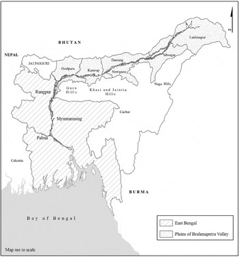
The Brahmaputra's floodplains, consisting of grassland, with a similar environment to that of East Bengal (Map 1), were considered best-suited for the cultivation of jute, as the requirements for the quality of soil, rainfall pattern, and availability of clear water in the alluvial tracts of the valley were all met.
Eastern Bengal and The Plains of Brahmaputra Valley.

The Brahmaputra's waters, indeed, contain a large quantity of matter including sand and silt in suspension, especially in the rainy season. The sand is deposited in the riverbed. The silt spills over to the floodplains and fertilizes the plains of Assam and Bengal. Sand is carried by the river until the slackening of the river's current allows it to settle down; this sand has been active in the making and unmaking of the valley's floodplains.
The river does not flow in one single channel; its braided channels continuously multiply. This also means that the river and its floodplains remain constantly in a dynamic state. The dynamic phase of the river and floodplains attains full momentum during the monsoon. This newly acquired momentum regularly forces the river and its many tributaries to change course. Changes in the river channels also often lead to permanent abandonment of some channels. Farmers quickly reclaim these abandoned channels (mora nodi), as they allow the soil to give a higher yield, as well as for a range of other purposes. Also volatile and very dynamic are the riverbanks. The dynamic character of the riverbanks is generally characterized as erosion, and lands closer to the rivers are vulnerable to a high risk of erosion. This high level of risk and the dynamic nature of the riverbanks have only prevented the growth of permanent cultivation in these areas.
These dynamic features of the Brahmaputra, its tributaries, and their floodplains, over the centuries gave birth to a floodplains-based agro-ecology. Peasants all along the river came to terms with these natural challenges and the river's ecological features.Footnote 23 At least since the middle of the first millennium, the valley's agrarian practices were reasonably tuned to the flooding pattern. Peasants made careful choices by avoiding flood-prone tracts. They commonly divided the the valley into different zones depending on their flooding patterns. Coming closer to the river meant enormous risk to the crops and thus their material well-being. As mentioned earlier, the rivers changed their courses often, making it difficult to cultivate close to their banks. The peasants avoided such hostile riverbanks and the floodplain. Keeping such tracts fallow for one season would lead to the growth of tall grasses; such vegetation was always welcomed by wild herbivores. But unlike the difficulty of clearing dense forests covered with trees, the reclamation of such tracts was easier, as it required only the burning of grasses in the winter. These areas were highly productive because of their fertility and the regular replenishment of nutrients by floods. Floods dynamically united the river, its islands, and floodplains. Normally, floods were a positive thing; they brought nutrients, fertilized soils, removed dirt, or destroyed the breeding grounds of mosquitoes. Riverrine populations had stocks of Assamese words—dhal, ban, and banpani (all meaning flood); pani aha and pani utha (both meaning rising water); and pani jowa (receding water)—to identify, explain, and categorize floods and their various types. This also shows that floods had different meanings and various outcomes.
The valley's peasants, nineteenth-century officials noted, knew well the characteristics of areas liable to regular inundation,Footnote 24 and they cultivated little in those tracts. The Assamese peasants cultivated such fields as an extra source of earning. Evidence suggests that until the late nineteenth century these peasants produced winter crops like mustard, opium, and pulses in these lands in order to avoid the risk posed by floods. Peasant production in these low-lying areas was thus organized on a temporary basis. Temporary farming (Pam kheti) disappeared during the monsoon.
The river's special features were its chars—the river islands or sandbars which are regularly formed. In neighbouring Bengal, and to a moderate extent in the valley, too, the government auctioned chars out to rich and powerful peasant families. As in the neighbouring Bengal Presidency, rich Assamese peasants always asserted their claim on such lands, often leading to legal disputes.Footnote 25 By the early twentieth century, with better access to markets, large-scale production of winter crops like mustard or cereals was already underway in these chars.Footnote 26Char's fluid geography remained a major hindrance to carrying out cadastral surveys. The government failed to impose revenue on such lands, so their high fertility and yield contributed little to the government's revenue.
There were some attempts to cultivate low-lying areas. Indeed, evidence of the construction of embankments to protect agricultural fields from floods could be found as early as the eleventh century.Footnote 27 In the fifteenth century increasing population pressure and increasing revenue demands forced peasants to reclaim agricultural land in the fertile low-lying areas. From that point on flood protection gained significant royal patronage. The Ahom rulers used corvée labour— compulsory labour service, similar to the corvée labour of European feudalism—to build embankments along the tributaries of the eastern part of the Brahmaputra.
This did not necessarily mean that the peasants in the valley were usually afraid of floods. Floods and agrarian cycles were compatible. Peasants considered silt left behind by the annual floods to be vital for the nourishment of their agricultural fields. Examples from other parts of eastern IndiaFootnote 28 show that flood dependency was common knowledge. For instance, peasants sowed a deep-water variety of paddy (bao) in these low-lying areas that could easily withstand prolonged floods. Flood-induced damages such as the failure of agricultural crops were frequent, but there was nothing unusual about this experience. Peasants were dependent on popular wisdom to predict the arrival of floods. Floods might hamper fresh reclamation of land in the plains, but the peasants would wait for the floods to leave behind the silt (polosh) that nourished agricultural fields. Any loss caused by flooding could always be compensated by the winter harvest. Colonial officials reported extensively on the peasants’ warm reception of floods until the later decades of the nineteenth century. Early twentieth-century research had already confirmed the benefits of silt.Footnote 29
Until the early twentieth century, colonial officials rarely expressed concerns about flooding. They noticed how the Assamese peasants considered normal floods useful to the fertility of the land.Footnote 30 Some officials also believed that floods could become destructive to crops only under certain conditions. A nineteenth-century colonial report noted how floods could ‘damage crops in two ways . . . both by the rapidity of the current which actually carries away the plants, and by the depth of the water, owing to which the plants are submerged, and so die’.Footnote 31 Floods in many parts of the Brahmaputra valley were considered to be of an ‘ordinary’ and ‘local’ nature, which did not cause widespread destruction and the loss of crops and property. Officials ascribed several reasons for this, most describing the interplay between flood and agricultural practices as the reason behind such limited damage. An official account thus noted, ‘The Brahmaputra and many of its tributaries occasionally overflow their banks, but the area subject to inundation is well known, and the villagers do not attempt to cultivate anything more than summer rice or cold weather crops in these flooded tracts.’Footnote 32
Geomorphological and ecological similarities also gave rise to shared agro-ecological practices along the river's middle and lower courses. These shared agro-ecological practices helped in the expansion of the political cultures of Bengal into western parts of the valley. The valley's western part mostly remained alternatingly under the rule of the local Koch and Mughal during the sixteenth and seventeenth centuries.Footnote 33 The Mughal land revenue system was deep-rooted here until the late eighteenth century. The river was the medium of a long, shared history of economic exchanges. The floodplains of the Brahmaputra could be best described as an ecological commons for various communities at different historical moments. The British empire's boundary- and frontier-making process unsettled these shared agro-economic practices in the nineteenth century.Footnote 34 The river's floodplains increasingly came to be seen as a space for distinct and exclusive political cultures, and jute emerged as a central character in this evolving story.
In defence of jute
As mentioned earlier, as the pressure to expand India's jute acreage increased, the government began to consider the Brahmaputra's floodplain, which it had considered waste, as the best place to undertake this expansion. The Bengal-based jute industrialists fully endorsed the government's view.Footnote 35 Accordingly, in 1898, the Indian government asked the Assam government to find out the prospect of jute cultivation in the valley. An official report reaffirmed the prospect of a massive expansion of jute acreage. The valley's aptness to produce jute was already well-known. Official investigations carried out in the 1870s had already noted the small scale of production of jute by the local peasantry in the valley.Footnote 36 Officials then mentioned the apathy of the Assamese peasants towards jute cultivation. This apathy was conditioned chiefly by the high cost of production.Footnote 37 The little jute that was grown in the valley (a mere 0.02 per cent of the entire Bengal production in 1872) was only a supplement to paddy cultivation, which was the principal crop.
Given this lack of capital and labour, who could undertake the fast reclamation of the floodplains for jute production? Speculation surrounding the Bengal jute industry had the potential to help the flow of capital, and capital would flow in from jute industries themselves. The Marwari traders became intermediary between Bengal jute industries and would-be jute producers in the valley. The government could not repeat the example of the tea plantations. The landless peasants from eastern and central India had continued to arrive in the tea plantations to work since the middle of the nineteenth century. British tea planters shared a widespread fear that any induced migration for purposes of smallholding peasant cultivation would drive away the existing workers from the plantation. The hope, thus, was on the villages of East Bengal. The Government of India had proposed ‘the stout and fanatical Mohamedan of Eastern Bengal’Footnote 38 as the natural choice to convert these areas into jute-producing fields. Officials argued that these farmers were ‘hardy and prolific cultivators. . .gradually working their way northwards. These people are accustomed to the risk arising from diluvion [sic] and devastating floods, which other cultivators are unwilling to face.’Footnote 39 The importance of Bengal farmers as the future settlers in the valley continued to win official endorsement. There were signs of landless peasants migrating to the western districts of the valley. The landlords of the permanently settled Goalpara had attracted peasants from the northern districts of East Bengal to their unused char land as tenants to cultivate jute. How does one explain the mobility of the peasants into the valley?
This migration into the chars of Goalpara—mention of which was found in the maps prepared by the British East India Company officials in the early nineteenth century—and subsequently to more central floodplain areas, unaided by the colonial government, was facilitated by a combination of factors. Apart from the linguistic-ethnic—not religious—similarities in the peasant society, the historical experiences of the floodplains of the Brahmaputra as ecological commons facilitated the mobility of the peasants. Perhaps the absence of any strong resistance from local peasant groups and any political border also played the role of a facilitator. Existing river routes and a new railway in the early years of the twentieth century made mobility comparatively easier. That floodplains in the western areas of Assam and the adjoining villages of northeast Bengal, from where most future migration would take place, had a shared ecology (as discussed above). This likeness is obvious in the river's flooding pattern, the unpredictability of the river channels, the volumes of sand and soil carried by the river, and the vegetation growing in the floodplains. Unlike northeast Bengal, the Brahmaputra valley in Assam was better protected from the ravages of cyclones.Footnote 40 This protection came from the Garo hill ranges along the south of the valley.
The ecology of the Bengal delta worsened during the early 1900s. The villages were regularly faced with waterlogging, waterborne epidemics, and floods which repeatedly resulted in crop failure as well as the under-exploitation of available agricultural land.Footnote 41 The villages of East Bengal were unable to recover from this until the mid twentieth century. The river's flooding regime also underwent significant changes. The major earthquake of 1897 changed the river's surface, bank lines, and the courses of its channels.Footnote 42 The river's ecological features became more fragile. All these factors led to the increasing loss of agricultural land. Decline of agricultural endowments spelt crisis for the peasantry.
If a shared and deteriorating ecology helped shape the condition for outflow of landless or smallholding peasant families to seek land in the middle reaches of the Brahmaputra, the Bengal peasants were further alienated from their resources. In the early years of the twentieth century jute markets almost collapsed and rice prices spiralled up. Low jute prices compelled many smallholding peasant families to mortgage their lands in lieu of credit. As they failed to repay their loans they ended up giving up their land to their creditors. Meanwhile, as population increase led to the fragmentation of landholding, more and more peasants took to jute for subsistence. This also helped credit to become firmly established as the principal mechanism for the expropriation of the peasant surplus. Increased indebtedness was accompanied by an intensified vulnerability to market fluctuations, which reinforced environmental worries. East Bengal had experienced ‘intensive margins’ of land use by this time, which exhausted the resources available for the peasants. Further, famines during 1896–1897 forced populations out of the densely populated tracts.Footnote 43 Years later, after the First World War, jute was no longer associated with wealth and vitality but with poverty, debt, hunger, and disease.Footnote 44
Growth of jute
Migration from these densely populated areas that were prone to natural calamities had already set in by the last quarter of the nineteenth century.Footnote 45 Most migrations took place during the first decade of the twentieth century. By 1911 around 118,000 migrants had settled in Goalpara. This constituted 20 per cent of the district's population. The Bengal partition of 1905 and the consequent arrangement of Assam and East Bengal into a single administrative unit boosted the mobility of the peasants. From then on, more landless peasants travelled eastward and settled in the interior tracts. Official accounts suggest that within three decades of the twentieth century, nearly 1 million peasants migrated from the East Bengal districts to settle in the valley.Footnote 46
Rapid settlement in the first two decades of the twentieth century helped the expansion of jute acreage.Footnote 47 In 1903–1904 and 1919–1920, the export of raw jute rose more than threefold. During the same period, the growth of paddy acreage stood at only 12 per cent. The industrial boom during the First World War encouraged jute industrialists to push for further expansion of jute cultivation in the valley.Footnote 48 The results were clear. By the Second World War, Assam was the third-largest jute producer in the country. Along with the migrants, local peasants—principally Assamese and Bodo—also expanded their jute acreage, but at a slower rate. Most migrants, moving in with their families, settled as small holders. The government also reaffirmed that all future land settlement in the valley would be based on the raiyatwari principle.
Migrant peasants had converted large patches of alluvial land—from an estimated 38,000 acres in 1902 to 300,000 acres in 1932—along the river Brahmaputra into a productive export zone. This land reclamation only confirmed the nineteenth-century colonial concern about the Assamese peasants’ supposed apathy towards production. Officials often described the Muslim peasants from East Bengal as ‘hard-working’ compared with the ‘simple and lazy’ and ‘non-productive’ Assamese peasants. Jute production meant the reclamation of tracts nearer to water bodies or low-lying areas, leaving forested savannah tracts as the only areas of the valley not under the plough.
Jute cultivation required capital and labour and simultaneously increased the flow of usury capital. Benefits went to both Marwari and Bengali traders as well as petty Assamese landlords-cum-traders. Credit flow was controlled by a complex nexus of traders and moneylenders. These traders-cum-moneylenders often fixed the crop prices during the time of loan payments. Also, by the time the valley witnessed rapid expansion of jute cultivation, Bengal jute industries, independent of the Dundee jute mill lobby, had become powerful in their ability to decide the prices of jute.Footnote 49 The majority of migrant families failed to overcome the economic and social burdens that they used to face in East Bengal. Indebtedness burdened them enormously. Their disappointment appeared in print and began to be circulated through folk literature. Heavy indebtedness continued to be noticed among the jute cultivators until a much later period.Footnote 50
Commercial production of jute massively impacted the ways in which the Assamese peasantry organized their economic practices. At the same time, the newly settled farmers’ agrarian practices, centred on jute production in low-lying flood-prone areas, appeared different from those of the Assamese peasants. Within a very short period, migrant jute farmers were able to reorganize the space of economic activities in the valley. Assamese peasants found themselves on the receiving end of such reorganization practices. Also, by the early decades of the twentieth century, floodplains were no longer exclusive resources for the rich Assamese peasantry. As the epidemics slowly disappeared, increasing population pressure on land located in ecologically safe places forced poor and landless peasants to seek land for cultivation in the riverine areas. Before this pressure was actually felt, the floodplains in the western part of the valley were slowly reclaimed by peasants who migrated there from the lower reaches of the river. Competition over resource use soon spilled over to activities such as animal husbandry. All these led to massive political dissatisfaction, which took various forms at different times and never subsided. Meanwhile, the demographic composition of the valley was highly impacted by this migration. In 1874, the percentage of Muslims in the Brahmaputra valley was 5.9 per cent. Over the next 65 years, this figure rose to one quarter of the valley's population. The rate of population growth was strikingly high compared to the India-wide average in the first three decades of the twentieth century. This could be partially attributed to immigration from East Bengal. The earliest setback to jute came after the First World War, when the wartime boom broke. By now, land settlements and jute production sparked intensive localized clashes. The government was forced to control the pattern of settlements. The Line System, as it was known, aimed at regulating settlement of East Bengali peasants in specific tracts.Footnote 51
Jute production reached an all-time high during the early 1940s. Until India's independence in 1947, jute produced in the valley was exported into Bengal (west). The partition of India suddenly disrupted the valley's river transport link with Bengal. This was a major blow to the jute industry, but migration did not stop. Another half a million migrated to the valley from East Pakistan during the short period between August 1947 and November 1949. Jute production continued to grow in Assam until the 1960s. After that it began to decline and did not recover until the end of the twentieth century.Footnote 52 Temporary growth in jute acreage after 1947 was partly influenced by the fact that jute prices rose as partition jeapordized Bengal's jute economy. While all the jute mills fell within India, almost four-fifths of jute production areas were incorporated into East Pakistan. Supply from East Pakistan to the Indian jute mills declined because of the imposition of export duty on jute and the political rivalry between India and Pakistan.Footnote 53 Prices increased and the valley was able to benefit from this until the recovery of Pakistan's jute industry.
Agrarian production, floods, and flood management
By the middle of the twentieth century, the floodplains of the valley, long considered by the colonial government as an idle zone, were transformed into a highly productive zone. The low-lying floodplains came under regular and permanent peasant cultivation. In the 1930s and 1940s, as jute prices began to show volatility, peasants tried to cope with the situation by shifting to paddy cultivation. In the later years of the 1940s jute prices went up. Over the next few years, because of the changing political scenario, farmers preferred a seasonal arrangement of both jute and paddy.
As East Bengali peasants settled down in the riverine tracts, the government became aware of the actual physical space of the floodplains. Paddy cultivation in the low-lying areas was easily susceptible to regular and repeated flooding, and erosion of the riverbanks was regularly reported by the revenue officials.Footnote 54 Moreover, jute producers in the valley had chosen the flooding season for jute cultivation so that they could also undertake paddy cultivation for the winter. Slowly, loss of land due to floods and erosion forced the migrant peasants to move out repeatedly in search of land, and new reclamation of land put pressure on the tracts where Assamese peasants had already settled.
As the valley's floodplains were reclaimed in the first half of the twentieth century, flood-induced damage to crops began to draw attention. Natural challenges to the highly remunerative jute crops could not be ignored by the government. Until early years of the twentieth century, the colonial government gave little importance to damage caused by flooding in the valley. Given the nature of the colonial government's perception of floods, no significant effort was made to invest in flood protection. H. Z. Darrah, the director of the Department of Land Record and Agriculture of the Assam government, writing to the Indian government in 1897, categorically admitted the absence of ‘any action’ for flood protection.Footnote 55 Yet, by this time the officials commanded a fair understanding of the existing networks of flood-protection mechanisms in the form of embankments, which used to criss-cross over several places in the valley. Poorly maintained high-raised roads dating back to the pre-colonial period continued to protect the homes and fields. That the valley's trunk roads acted as embankments and protected the urban settlements and agricultural fields was fairly accepted within official circles. The government's limited engagement with the question of floods in the valley began to change in the twentieth century. Official reports began to note increasing damages to jute caused by flooding. However, no official investigation was carried out to understand the sudden escalation of floods.
The twentieth century witnessed repeated increases in the pre-monsoon rains.Footnote 56 Floods induced by monsoon rains caused further damage to jute crops. Inundation of new areas was also reported which resulted from the changing pattern of the monsoon. In the last three decades of the nineteenth century (1871–1900) flooding occurred mostly during the monsoon period. Pre-monsoon floods were infrequent. This meant that the predominant traditional crop cycles based on the winter crops were less susceptible to damages. Also, before the river and its floodplains could recover from the massive ecological impact of the 1897 earthquake, another major earthquake, measuring 8.6 on the Richter scale, shook the valley in 1950. The river regime underwent further transformation. Several reports afterwards pointed out that the bed of the Brahmaputra had risen considerably. Siltation increased, and in several areas the river changed its course. All this led to increasing erosion and land loss. Increased siltation and changes in the course of river channels contributed to the dynamics of the riverine area. Subsequent floodings resulted in a slow decline of agricultural endowments. The 1897 earthquake made a small number of tea plantations in eastern Assam vulnerable to floods,Footnote 57 although only a few plantations fell victim to flooding. It was rare for plantations to be established in flood-prone areas. A few urban settlements, like Dibrugarh, suffered irreversible damages owing to flood and river erosion. As the intensity of floods and river erosion rapidly multiplied, it unfolded a crisis in peasant agriculture. To the government, these were causes for concern which warranted some intervention.
Explaining floods and the search for a remedy
Fresh appraisals of the causes behind the floods started to refer to their increased intensity after the 1897 earthquake; the easiest way to explain their increasing ferocity was by reference to the earthquake. Reports prepared by the Geological Survey of India in 1898 showed rising riverbeds and predicted that the river, having to carry and distribute away silt, would take a longer time to return to a stable situation. This explanation did not lead to any safeguard against flooding. Structural intervention into the river system was seen as a possible means to avoid floods. The dominant view was that the most pressing need was for sound engineering solutions. Over the next few decades, several commissioned surveys suggested possible remedies apart from trying to explain flooding and the causes of the river's behaviour.
The government tried to respond to the floods by declaring a waiver of land revenue and granting monetary and grain relief. Often agricultural tools and cattle were distributed. In some places, homestead and cultivable land were granted to peasants displaced by floods. Such actions were needed precisely to overcome huge losses in land revenue. However, attention was not limited to pro-peasant actions. The government considered other measures that could be employed to lessen the adverse impact of floods in the valley. For instance, in 1918 F. O. Lechmere-Oertel, the chief engineer of the Public Works Department in Assam, argued that the remedies for floods rested in alleviation, not prevention. He argued that the advantages of the floods should not be lost sight of while studying their adverse effects. He reiterated that ‘these floods are by no means an unmixed evil, the harm done in one year being often more than compensated in succeeding years by the increased fertility of the land through the silt deposited on it. It is only when there is a succession of abnormal flood years that the cultivator seriously felt the stress.’Footnote 58
The chief engineer emphasized that continued fertility of the cultivated soil was necessarily dependent on its exposure to the silt brought down by the flood water. He made it clear: ‘Nothing that could interfere with the raising of the low lands by silting, such as marginal bunds along the edges of rivers for the purpose of protecting fields from inundation, which were in use in Assam long before the British occupation, should be permitted.’Footnote 59
The most prolonged, devastating, and unprecedented flood came in 1929 and affected the central part of the valley, a major jute-production area. While this flood was also induced by heavy pre-monsoon rains, a combination of factors including new trunk roads and railway tracks on both the sides of the riverbanks aggravated the damage caused by flooding. The flood drew widespread attention in official circles, which came to be haunted by the fact that low-lying areas in the western part of the valley had become vulnerable to floods. Floods returned to central Assam again in 1933, causing widespread damage to jute crops. In a bid to overcome the challenges posed by floods, the government began to search for some urgent remedies.
By 1929, despite this mixed reaction, structural remedies for flood protection became standard vocabulary among technocrats in Assam.Footnote 60 A committee was appointed to examine the railway tracts in the valley as a possible cause of the floods.Footnote 61 The committee inferred that the newly introduced railways and public roads, which criss-crossed the floodplains, aggravated the floods, as there was not enough space for the passage for water.Footnote 62 The railway tracks seriously obstructed the natural flow pattern of flood water. Challenges posed by these artificial barriers, against the flow of flood water, were usually of a grave nature. Also, peasants in affected areas requested that drainage systems be implemented in the railway tracts for the release of flood water. Flood damage, the committee felt, could be controlled by effective change in the bureaucracy, installation of gauges, and dredging of the river. A waterways department was also proposed so that the river could be kept under constant and effective monitoring. Like the rivers of eastern India, the committee suggested the installation of gauges for a better understanding of floods.Footnote 63 The report also hesitantly recommended that the lower reaches of the river be dredged.Footnote 64 The idea of river dredging was already a much-debated aspect of river engineering in Europe and America.Footnote 65 The Orissa Flood Enquiry Committee of 1928 had already adversely commented on the outcome of dredging. It argued that dredging only led to disruption in the deltaic formation and could not stop the deposit of sand. This resulted in the ultimate failure of any dredging work.
In the valley no dredging work took place, nor was a waterways department established. What became noticeable instead was a better quantification of flood damage. This was important given that floods now meant an increasing uproar from Assamese nationalists for the remission of land revenue.Footnote 66
The idea of dredging the Brahmaputra resurfaced in the 1950s and 1960s.Footnote 67 Within popular imagination, dredging was the best possible remedy against floods. Assamese technocrats, not trained in river engineering, voiced their opinion in support of river dredging. Despite financial stringency for such a massive physical intervention, the Assam government decided to dredge the Brahmaputra experimentally in 1966–1968.Footnote 68 The government claimed, ‘the dredging is to preserve the main channel of the river at a suitable distance from the banks’. This would not only ‘liberate a larger volume of drainage but also its banks and embankments’.Footnote 69 Another experimental dredging was carried out in 1974.Footnote 70 The high cost involved in dredging ensured that such experiments remained confined to small stretches of the river. The results of this small experiment were not very convincing. Officials admitted that although dredging could prevent bank erosion, it proved not to be a particularly effective measure; the dredged segment promptly filled up once more with silt. What was required for an effective dredging was to undertake further engineering work ‘to train the river to flow through the dredged area and to remove the earth’. This optimism could not be put to the test due to the huge expenses involved. By the twenty-first century, the idea had become unattractive among the river technocrats.Footnote 71 But despite this perceptible shift in attitudes to the benefits of dredging, there was an increasing popular demand for dredging further downstream.Footnote 72
Surveys into the causes of floods increased in the second half of the twentieth century. International engineering cooperation was limited until 1950, and no physical survey of the river was conducted. In the 1950s and 1960s international help was sought; support came in from the United States Army Corps of Engineers, which gave advice on how to control floods. Suggestions included dredging the river and constructing storage reservoirs and embankments as possible protection against floods. The only exception in this period was S. C. Majumdar, a senior engineer credited with extensive works on the rivers of Bengal delta and also a key person advising the Indian state on the question of floods. Majumdar came down heavily on the benefits of embankments, unhesitatingly predicting that they would be a disaster.
Devastating floods swept away crops and other properties in 1950, and earthquake-induced flooding led to the loss of human lives, crops, and animals. Assam experienced severe flooding in 1954 along with several other northern and eastern Indian states.Footnote 73 The 1950 earthquake and the resulting floods, especially those during 1954, helped engineers to better explain the river topography and its relation to floods. Floods, now of a much higher intensity because of the 1950 earthquake, prompted the Indian government to draw up an urgent flood strategy. A survey conducted in 1954 found that the siltation pattern had changed dramatically because of the earthquake. The riverbeds were full of tough clay soil rather than their natural sandy material. This soil came down heavily from the exposed hills. The catchment areas became volatile. Landslides brought down timbers, clogging the channels. All these factors led to unusually heavy silting. Raised riverbeds helped the river channels to change their courses rapidly.Footnote 74 Well-formed bank lines also suffered from erosion, and the erosion of high banks flooded new areas that had long been settled and turned into productive agricultural fields.Footnote 75 Away from such official surveys, an alternative explanation came from a British botanist, Francis Kingdon-Ward, who was intimately familiar with the lower Himalayan hills and upper reaches of the Brahmaputra.Footnote 76 Ward pointed to the complex nature of the catchment areas of the Brahmaputra and its tributaries to explain the varied nature of the floods.
These surveys also exposed the larger doubts of the Indian state about rivers and floods in the valley. It was agreed that structural solutions alone could not be the answer to the flood problem. Attention was also drawn to the subject of protection and management of the landscape and watersheds. But such voices were feeble. Deforestation in different parts of the region came to be increasingly identified as the primary cause of floods. The large rainfall catchment area of the Brahmaputra basin and the role played by the monsoons came to the forefront. That the flood-prone areas needed better flood warning systems was also suggested. Equally, concerns were raised about the effectiveness of embankments as an instrument of flood protection. Meanwhile, engineers with experience of the valley's rivers suggested that the embankments were a catalyst for confinement of flows. The latter led to increased flood levels as embankments reduced natural drainage and augmented waterlogging. The Indian government increasingly came to believe that engineers could undertake complete flood protection works. At the same time a 1958 report by the Government of India unanimously stated that ‘the various flood control measures either executed or visualized should not lead to the wrong impression that complete immunity from flood damage is physically possible in some distant future. Any such illusion has to be dispelled.’
The government conducted more surveys after 1958 which continued until the end of the twentieth century. These surveys largely agreed with the threefold issues of embankments, storage reservoirs, and dredging as a solution to floods. The surveys equally expressed uneasiness at the sheer unpredictably of the behaviour of the Brahmaputra. Probable cure lay, surveys agreed, in the effective control of watershed, erosion control, and stabilization of the Brahmaputra to single channel.
Meanwhile, the 1954 Indian national policy on floods continued to be the guiding principle of Indian flood control regimes.Footnote 77 Political intervention came in 1964 when an Indian ministerial committee re-examined the flood control issue.Footnote 78 The committee, reaffirming its faith in the existing embankments, suggested that the inter-basin diversion of river waters would reduce floods in the valley. The committee also repeated the idea of construction of a multi-purpose dam. Advice for non-structural intervention also came in: flood forecasting, floodplain zoning, and flood insurance. The committee suggested that soil conservation was the core issue for future flood management. These ideas resurfaced in 1972 when another ministerial committee pointed out the issues. I will return to these issues a little later.
In sum, by the middle of the twentieth century, the river technocrats began to argue about the need for flood control and constructing embankments as a remedy against recurrent floods in Assam. Floods, the majority argued, could be controlled by erecting embankments which would help prevent water from spilling over to the fields. This would in turn protect both crops and human lives. Embankments would help to stabilize river courses and regulate a regime of controlled water flow in the river channels.
Floods and Assamese nationalists
Following the repeated failure of crops and an imminent famine-like situation in the state in the 1940s, the Assamese ruling classes focused their attention on overcoming the problem of floods. Assamese elites began to consider the ferocity of floods in the Brahmaputra and other rivers in Assam as a cause of sorrow and suffering to Assam and the Assamese peasantry. Assamese politicians across ideological divides convincingly argued for the need for river control. It was perceived that flood control would restore to health a crisis-ridden agrarian economy. The best example of such articulated voices surfaced on the floor of the legislative assembly. Inspired and heated debates on floods took place in the assembly, and often these went on for days. In 1947, the acclaimed architect of modern Assam, Gopinath Bordoloi, strongly argued for the immediate need of river engineering: ‘The best method as is now advocated by the scientists is that the river could be best controlled by putting some dams.’Footnote 79 Such concerns repeatedly surfaced on the floor of the assembly. That the river and its systems created havoc for the peasant economy of the region came to be emphasized by others, too. Hem Chandra Barua, another Assamese nationalist, wrote:
it is quite often that they over bring [sic] and spread across the fallow lands in great pressing volumes, and destroy cultivation, human habitation and cattle lives. At times, whole villages far and near are swept away. In a miniature scale, they are, in the destructive aspect of thing, like of the often heard tidal wave [sic] of the Japanese islands.Footnote 80
The ruling classes in Assam, political leaders, senior bureaucrats, engineers, and a host of contractors, after 1950, tried to solve the problem of increasing floods through a series of political debates. They all mastered the right language to win over the peasantry; whether it was on the floor of the legislative houses or public platforms, no one spared any opportunity to speak about the urgent need for flood control, and everyone found an answer in the construction of embankments. All agreed that floods seriously disturbed the valley's agrarian economy. Public opinion and political fora spoke about the extent of the loss of cultivable land because of floods, and political intervention was deemed the best possible remedy. The confidence of the government in the ability of embankments to prevent floods and protect agriculture is clear:
In a backward country like Assam, where agriculture dominates the economic life of the people but where methods of agriculture are still primitive and Nature plays the most important role in the production of food, the importance of embankment and drainage works are being realised by our people every day. . .The government have realised the necessity of a comprehensive embankment and drainage system scheme in the state.Footnote 81
As floods and flood crises worsened after the 1950 earthquake, the Assamese ruling elites sought financial help from the Government of India. This was done with an aim ‘to take necessary steps to train or otherwise deal with the river Brahmaputra in order to stop floods which are devastating the state almost every year causing huge loss to the agriculturists’. Several issues became clear. First, it affirmed that the Indian nation-state was able to tame the river and control flooding. Second, Assam could not manage the river alone, owing to a lack of resources. This twofold approach continued to shape the Assamese ruling classes’ attitude to the river and floods. That river engineering through embankments would pave the way for safe cultivation was widely appreciated. Some suggested that this would open up new areas for the extension of permanent agriculture along the Brahmaputra. Such rhetoric also served to strengthen the ruling classes’ dominance over the peasantry. The Assamese peasantry was not convinced of this political rhetoric and only hoped for some miracle to happen. The government of Assam, throughout the 1950s, repeatedly admitted its failure to give justice to the flood victims with its ‘limited state resources’ and appealed for central funding. The role of floods in making Assam's underdeveloped economy came to be highlighted.Footnote 82
Between 1982 and 1987, Assam sought flood relief amounting to  6,610 million from the central government and received assistance of 1,150 million.Footnote 83 The area of flood-prone land in Assam was estimated to be 3.15 million hectares. Contemporary commentators agreed that the discrepancy between the volume of financial support sought and the support granted was in part because of differences of opinion on estimates of the damages and ‘a general shortage of financial resources, and also in part political bias’. The increasing failure to provide finances to remedy flooding forced the Assamese ruling classes to argue for the declaration of the floods as a ‘national problem’. But the Centre did not respond. Over time, flooding contiued to emerge as a ‘national problem’. For the Assamese ruling elites, this was another example of the problem of the federal structure of the Indian government.
An era of embankments (1947–1980s)
Emboldened by the experiences of other parts of India, an Embankment and Drainage Department had already been working in Assam since 1944. The department's primary task was the upkeep of the river drainage system. The department's mandate was to build embankments and divert the river wherever possible. The construction of embankments began in 1947, and about 200 kilometres were completed within few years.Footnote 84 The previously slow pace of embankment construction gained rapidity after 1954. Between 1950 and 1954, floods resulted in massive damages to crops and property. The impact of the 1950 earthquake on the valley's rivers was increasingly noticeable: the riverbeds rose; there were increased volumes of silt in the Brahmaputra and its north bank tributaries; flood waves reached out to new and higher areas. Along with poor farmers, the rich farmers, closely linked to the sources of political power, were adversely affected.
The building of embankments gained massive political backing from the middle of the twentieth century. Construction of embankments was undertaken on a war footing. A few select towns with small areas dotted with tea plantations and extensive stretches of land for jute-growing were provided with flood protection. The most publicly visible urban protection work was for the city of Dibrugarh in eastern Assam, which had key tea plantation interests.Footnote 85 Suggestions were put forward to raise the height of some flood-prone villages. This could be done through the construction of new embankments and spurs.Footnote 86 The viability of extending the existing embankments and improving the drainage channels were now investigated. This gave an impression of a radical ideological shift in the government's understanding of floods and its willingness to tame the river.
But confusions prevailed. The government argued that embankments would provide only temporary relief. Official reports pointed out how the valley's geological constraints went against the whole idea of flood control. As a way out, the government recommended further technological studies on the river with the aim of proposing multi-purpose river engineering.
As embankments emerged as an answer to flooding, there was a focus on state instrumentalities as means of controlling floods. In 1953, the Assam government reinforced an existing legal instrument, the Assam Embankment and Drainage Act 1953, in an apparent bid to control floods. Further, in 1957 it passed the Assam Embankment Act. The government also set up several other institutions to decide on matters related to both technology and financial support for embankment construction. In the following decades as embankments were increasingly built to combat floods they simultaneously gave birth to a class of interested groups; contractors, petty traders, lower-ranked officials, and locally influential villagers all became important partners in the construction of embankments. Thus, embankments now played an important role in electoral politics and soon became an instrument for electoral victory.
Embankments lined up across both banks of the Brahmaputra and its tributaries. In the western and central part of the valley, they protected the jute fields. After three decades, one third of India's embankments were in Assam. Between 1954 and 1987 Assam built 4,448 kilometres of embankments and 599 kilometres of drainage, in addition to soil conservation measures. The official claim was that the embankments protected an estimated 1.56 million hectares of agricultural land. Embankments worked well in the early years of their construction. They also served as roads and places of shelter during floods, for both humans and domestic animals. In 1975, the Indian government reaffirmed its sustained effort to train personnel to tackle the problematic subject of flash floods. For the government, the obvious solution was to construct another embankment, despite knowing that it was doomed to failure. Yet the government turned a blind eye to the repeated failure of embankments.
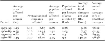
In popular opinion, the floods of 1986 and their devastating impact in the central part of the valley were caused by the newly built storage dams across the southern tributaries of the Brahmaputra. Official accounts did not mention storage dams as a factor in this flood as the government was not convinced of their negative impact. Despite great efforts and massive spending (more than Rs. 15,000 million) on building channels and a 431 square kilometre area for soil conservation, floods continued to occur. There were disastrous floods in 16 of the years between 1954 and 1998. Each year floods affect 12.21 per cent of the geographic area of Assam, which equates to more than 9,600 square kilometres of land (Table 1). In 1998, four waves of floods flooded 38,200 square kilometres, or 48.65 per cent of the geographic area of the state, endangering the lives and properties of 15 million people.Footnote 87 Official circles, however, believed that the issue of flooding was under control, andFootnote 88 the recurrence of floods was considered to be the result merely of mechanical failures in structural solutions, which could be easily improved upon.

The ecological degradation of a landscape
Problems with embankments surfaced quite early on. The regime of flood control through embankments was based more on local political needs than a combined application of science and river ecology.Footnote 90 The efforts of the Embankment and Drainage Department often resulted in unforeseen damages and public protests. Occasional river engineering took place which attempted to divert excess water into shallower rivers in the neighbourhood. In fact, opinion in the government itself was divided on such engineering works. For instance, in 1950 the department tried to divert water from the Buri-Dihing to Noa Dihing in the eastern part of the valley. Its effectiveness was never recorded, but the government heavily condemned such works.
A distrust of embankments became increasingly evident.Footnote 91 The Indian government agreed that although ‘embankments were providing a certain degree of protection at rather low cost, the effects of embankments on [sic] river regime were not well understood’. In the late 1970s the Indian Planning Commission argued:
One of the important causes of occurrence of floods viz., the devastation of forests and lack of other conservative measures on the catchment areas of the rivers leading to heavy soil erosion and consequent increase in silt load in rivers, has not so far received adequate attention.
In the 1970s more reports highlighted the consequences of the embankments. The National Flood Commission of India in 1976 highlighted several challenges of flood control through river training. The Commission agreed that river aggradation posed a threat to the safety of the embankments. The Commission also reiterated the findings of the 1929 Flood Enquiry Committee on the role of the railway tracts in floods. The Commission noticed that the north bank tributaries in western Assam continued to cause floods along the railway tracts upstream. That some rivers on the north bank of the Brahmaputra refused to be tamed continued to haunt policy-makers and technocrats. Some tributaries were erratic in their behaviour, carrying heavy silt, and often experienced flash floods. Many tributaries were interdependent and the flow pattern of one river could influence that of another neighbouring river. They changed their course erratically, causing unpredictable and extensive damages to crops. The Commission, however, agreed that although the agricultural fields were now deprived of silt, there could be no conclusive proof of whether they were deprived of their sources of renourishment.Footnote 92
After several years of experiments with embankments, and repeated floods, a sense of uneasiness was noticeable among the ruling class. The 1986 flood came as an eye opener. An expert committee which looked into the flood problem, admitting that such intervention had changed the behaviour of the rivers in Assam for the worse, suggested that no more embankments should be constructed to avoid the recurrence of such calamities.Footnote 93 An official survey highlighted the loss of land, embankment failure, and disruptions to fish breeding between the floodplains and rivers, which reduced passage for the flow of flood water.Footnote 94 The embanked rivers came to be characterized by erodible bank lines and heavy siltation. The troubles did not end there. For instance, floods breached embankments and threw this engineering solution into serious disarray.Footnote 95 High silt loads carried by the rivers changed land drainage patterns in the floodplains and were considered to be major factors behind the flood of 1986. High silt led to the choking of river channels. River slopes decreased, andFootnote 96 embankments added to the process of filling and raising the level of the river channels. Prior to the construction of embankments, flood water would push the silt to the distant fields. A controlled river channel meant silt remained in the channel.
Embankments could control the erosion of the riverbanks.Footnote 97 Often, as in 1998, embankments failed after they became saturated following a prolonged period of flooding and relentless rainfall.Footnote 98 Erosion brought riverbanks close to the embankments, which led to breaches. Sudden breaches damaged crops and properties;Footnote 99 both paddy and jute suffered hugely in the western and central parts of the valley at regular intervals. At this time there was increasing evidence about how the embankments led to a high level of flooding within the embanked area. There was a rise in the riverbeds which led to a reduction in the fertility of land in the flood-protected area. The government conceded that the embankments, through breaches and the entry of flood water, regularly allowed flood-protected areas to become submerged. The threat of waterlogging and drainage congestion increased, and the mechanized outlet instruments failed repeatedly. Technocrats unanimously held that all this resulted in the rising of riverbeds and narrowing of the channels. ‘The land drainage pattern changed drastically because all streams were now guarded by marginal embankments.’Footnote 100 Aggradations of the riverbeds occurred because of the increasing siltation of the river channels. The silt that was now deposited inside the channels used to be deposited in the flood-plains. For a long period, this silt was considered a key element in land fertilization. Meanwhile, as work on structural interventions into flood management advanced, it became obvious that erosion control was inescapably connected to flood management. Embankments which were intended to reduce overbank spill were being destroyed by river erosion and thus multiplying the problems. Rainwater that fell outside the embankments was obstructed by them and so failed to recede to the river, instead remaining in the fields and, leading to the formation of bodies of stagnant water. Water hyacinth growth also reduced drainage efficiency. Thus, embankments were constructed at the cost of massive and irreversible damage to the wetland bodies.
Flood control through embankments also put local social relationships into disarray. The idea to construct embankments was based solely upon the hydrological behaviour of the river, and the intricate social relationships of people across different communities with the river and floods did not fit into this hydrological understanding. The idea of damage was also based upon such a perspective, and the idea of compensation was articulated in various ways.Footnote 101 Localized dissent emerged which contested such views about water and the river. For example, fishing communities relentlessly resisted the move to construct embankments in eastern Assam.Footnote 102 They argued that embankments would jeopardize their livelihood, while others, who depended on agriculture, welcomed it in the hope that their crops and properties would be protected. As time passed, the embankments had to be protected through state-sponsored patrols.Footnote 103 Often such vigilance did not help, and human-induced breaches took place. Cattle were also blamed for breaches.
Notwithstanding such challenges, the government continued to endorse the structural remedy of maintaining embankments, as well as new engineering measures, which included additional protection against challenges like seepage, wave wash, or erosion by river currents. As water levels rose, the height of embankments was increased almost annually. Reflecting on the decades-old experiment with embankments, early in the twenty-first century the Indian government conceded:
throughout the more than three decades during which flood management policy was evolving, necessity dictated that physical interventions continued. Despite well-founded concerns over embankments, they were in fact the only reasonably cost-effective measure that afforded protection from lesser floods, and their construction went on practically unabated in the Brahmaputra. . .Footnote 104
Shifting alliances of agriculture, ecology, and capitalism
The introduction of cash crops in the flooded areas of the valley had firmly connected Assam's agrarian economy to the international economy. The late colonial government introduced flood protection in the valley to sustain these linkages between the floodplains and global capital, where tea plantation had only a marginal role to play. Their flood protection policy, despite providing occasional relief to crops and human lives, ultimately led only to intensified flooding. Flood protection invited more settlement in the low-lying areas, and as flooding intensified, these areas witnessed serious damage to life, property, and crops.
However, in the middle of the twentieth century, there was an ideological shift towards large dams away from embankments. India's First Five-Year Plan (1951–1956) stressed the need for large dams both for the production of hydroelectricity and the creation of facilities for irrigation. Several rivers in northern and eastern India became part of this new thrust, although no dam was considered for the Brahmaputra. There are several possible reasons for this. Public and private finance did not see profit in such investment. In Assam this shift also coincided with the post-1960 declining trend of jute production. By the last quarter of the twentieth century jute had lost its crucial economic importance. Global capital, the driving force behind the expansion in jute cultivation, seemed to have foreseen this and had slowly withdrawn from the field. Jute farmers, however, did not stop cultivating jute, albeit without the entanglement of speculative capital, and became prisoners of an uncertain future.Footnote 105 Years of low prices forced them to seek governmental intervention. In response, on 10 October, 2011 the police shot dead four of the jute farmers who protested against the government's apathy.Footnote 106 This was only a single episode in the larger story of the decline of the political and the economic relevance of jute.
The floods did not cease, but still the idea of flood protection did not receive any financial support.Footnote 107 In the twenty-first century the Indian government, ignoring the historical complexities and ecological consequences, gave high priority to the Brahmaputra as a site for the generation of hydropower. The floodplains and the agricultural activities that took place on them were seen as less productive than using the river as a commodity to produce hydropower. All such river training schemes were now dissociated from promises of flood protection and the improvement of agriculture.Footnote 108
So, by the late twentieth century the Indian state assumed a new role in facilitating capital to reconnect with rivers and their floodplains. Scientific research on the river and its ecology progressed significantly during this period. There was also improvement in the sphere of river engineering. Modern capitalism has relied considerably on these advances to redefine its relations with the river. This changing dynamic between science, ecology, and capital was reflected in a shift from embankment to hydropower dams. But in all this, jute cultivation and its requirements had no place.