

INTRODUCTION
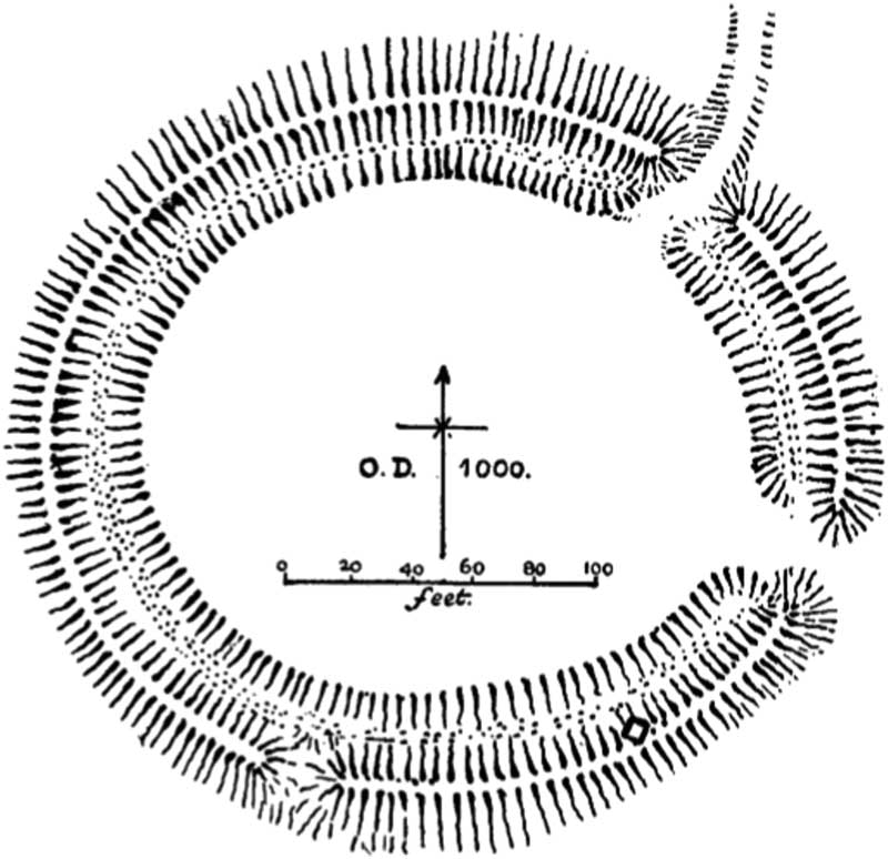
Castle Dykes (National Grid reference sd 98231 87289) lies at c 305m od (ordnance datum) some 2km south-west from Aysgarth in Wensleydale, North Yorkshire (fig 1). It was first surveyed by Allcroft (fig 2),Footnote 1 who compared the site to Arbor Low, then recently dated to the Late Neolithic/Early Bronze Age by St George Gray.Footnote 2 Allcroft reasoned that of three gaps in the bank only that on the east was original as it had a corresponding causeway across the ditch. He also noted a large stone protruding through the turf on the south-east arc and suggested that a peristalith may have stood along the crest of the bank, though this is unlikely. Castle Dykes appears in Atkinson’s list of Class i (single-entranced) henges and in Atkinson’s later corpus,Footnote 3 Harding with Lee largely repeat Allcroft’s description.Footnote 4 However, the aerial photograph that they reproduce clearly shows the drainage channel running from the gap in the northern bank. The southern gap in the bank can also be seen to lack a corresponding break in the ditch and there is a slight hint of a third break in the bank to the west in an area of springs. In his general book on the Yorkshire Dales’ landscapes, WhiteFootnote 5 tentatively hints at the potential Neolithic date of some undated enclosures but is more certain about the dating of the henge of Castle Dykes due to its classic form.
Location map of Castle Dykes henge. Diagram: Alex Gibson.

Allcroft’s Reference Allcroft1908 survey of Castle Dykes. Reproduced from Allcroft, Reference Allcroft1908, fig 195.

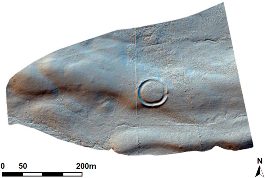
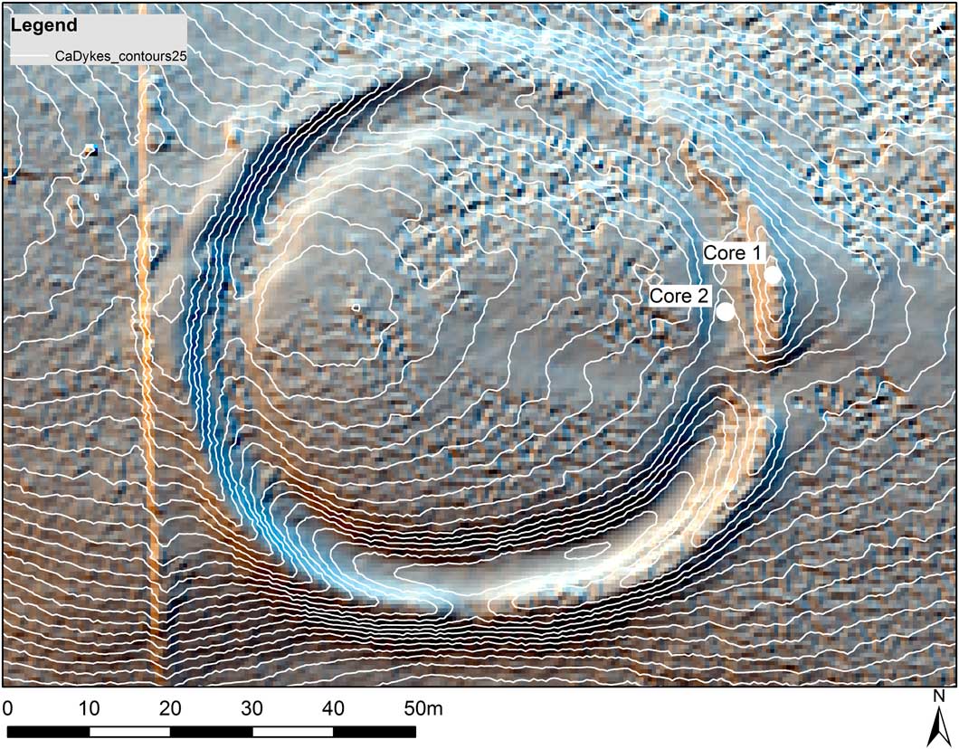
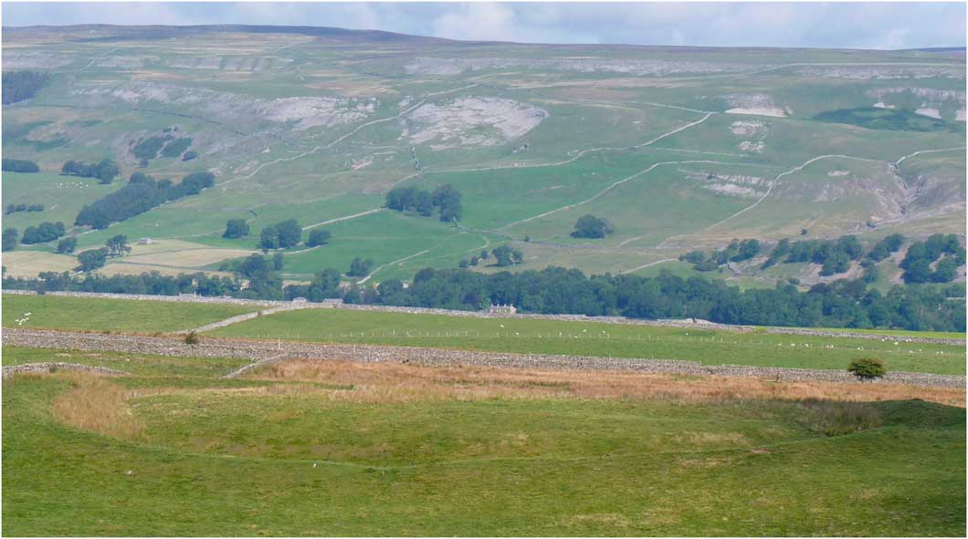
The enclosure is slightly oval and lies on the crest of an east-sloping spur. It has an overall diameter of c 81m (c 53m internally) (figs 3 and 4). The well-preserved bank measures up to 9m across and up to 1.2m high. The internal ditch reaches 4m wide and 1.1m deep from ground level. As Allcroft noted, there are traces of three breaks through the bank, but only that on the east appears to be original; those on the south and north do not correspond with a causeway in the ditch, and the latter appears to be modern and perhaps resulting from an attempt to drain the northern half of the waterlogged ditch (a slight channel runs northwards and downhill from this break) (figs 4 and 5). There are hints of large stones in the bank on the south-east quadrant and the HER records the removal of other stones, though how many and from where is not recorded. This may just be derived from Allcroft’s speculative peristalith. The southern half of the ditch circuit, despite being downhill from the centre, is not waterlogged and appears well drained, probably due to the nature of the underlying geology (discussed later). There is also a slightly hollowed area leading up to and within the entrance (see figs 4 and 5).
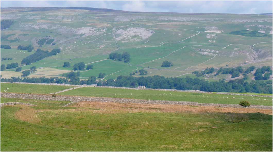
Castle Dykes looking north. Photograph: Alex Gibson.
Digital terrain model of the Castle Dykes ‘henge’. Laser scan image: LBI.
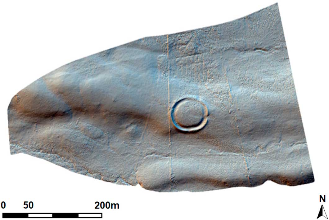
Castle Dykes contour survey – 25cm intervals with locations of cores marked. Laser scan image: LBI.

The enclosure was surveyed and sampled as part of the main author’s Henges in the Dales project, which had already seen trial excavation of the henge at Yarnbury and geophysical survey at the pair of henges at Threshfield, all of which lie in Wharfedale.Footnote 6 The Iron Age date for the site was therefore unexpected and raises further questions about the reliability of morphology alone for site classification as well as the extent of later prehistoric emulation of earlier prehistoric monuments. Does this represent an appropriation of the past, the creation of local ‘histories’ or are there other, more practical, considerations for this apparent replication of earlier architecture? These themes will be considered later after the presentation of the results of the survey and sampling.
SURVEY
Until recently, Yarnbury and Castle Dykes were the only two single-entranced ‘henges’ known in the Yorkshire Dales.Footnote 7 They both have classic external banks and internal ditches, but both are unusual in that they lie on high spurs or crests between their main river valleys and smaller tributaries. They also do not appear to be associated with contemporary monuments. During an earlier survey in Wharfedale,Footnote 8 two more henges were located, at Threshfield near Grassington. One single-entranced enclosure contains an internal oval of pits, while the double-entranced henge still survives as an earthwork. Following and building on the Wharfedale surveys, and the small excavations at Yarnbury, a further survey was planned at Castle Dykes to core the waterlogged ditch. The project was directed by Alex Gibson in collaboration with Mike Allen and Wolfgang Neubauer. The sampling was undertaken in June 2015, with the survey taking place over one week in the following September.
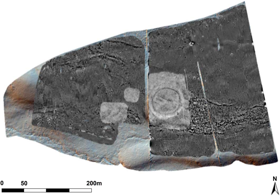
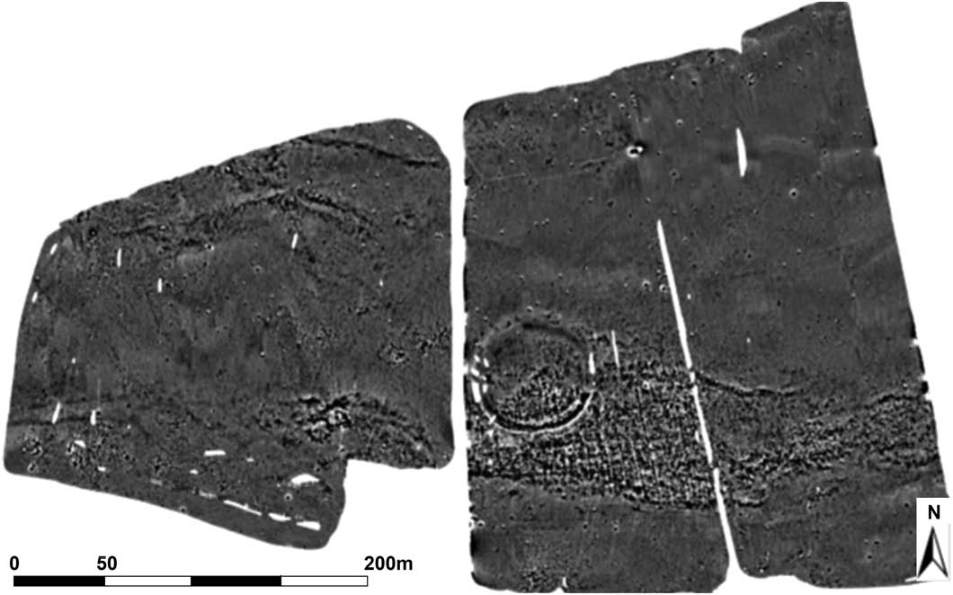
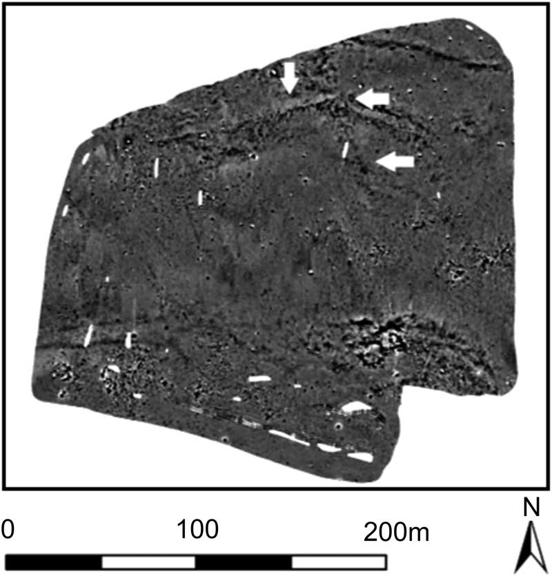
The survey area totalled 15ha and was designed to search for internal and external features. The lay of the land, areas of bog and streams meant that 12.3ha could be surveyed by magnetometer (fig 6), while terrestrial laser scanning covered the entire area (see fig 4). Possible features noted on the magnetometry were surveyed using ground-penetrating radar (GPR) and approximately 1.4ha were surveyed by this method. The magnetometers and GPR antennae had a traverse separation of 25cm and magnetometer reading intervals were at c 10cm (depending on driving speed) and GPR reading intervals were at c 8cm.
Area of magnetometer and GPR survey at Castle Dykes. Magnetometer image: LBI.

RESULTS
Geophysical survey
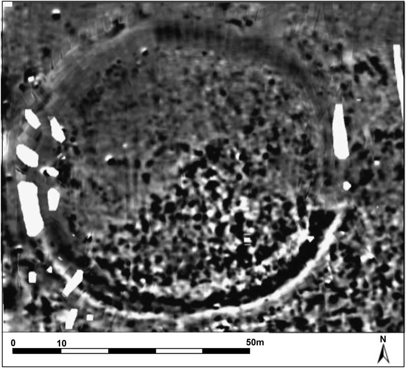
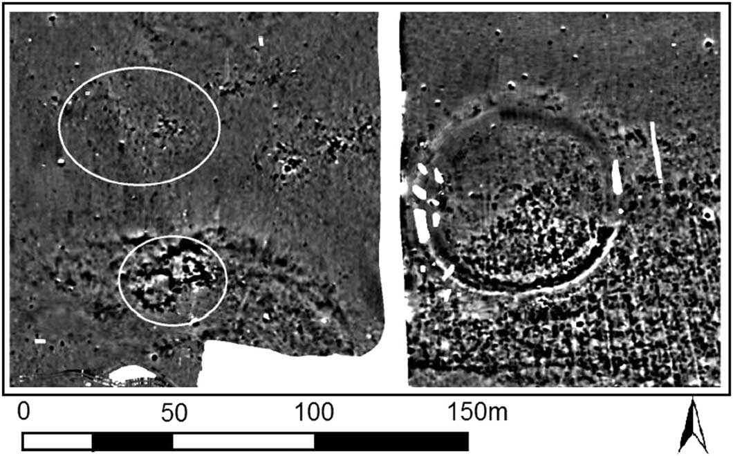
The results suggest that the site is not part of a larger ritual landscape and that potential archaeological features largely comprise possible pits (fig 7). There are, however, some small interrupted circular features, the first of which lies within the centre of the enclosure but does not appear to be exactly concentric with it (fig 8). An arc of six elongated pits (Structure 1) runs into an area of geologically generated interference in the southern half of the enclosure, and it is uncertain whether the pits form a full circle; if they did, such a circle would have had a diameter of c 15m. There is a concentric arc, more linear than pit-like, about 3m to the outside of the pit circle (see fig 8), but once again a full circuit cannot be demonstrated. Although detectable in the GPR survey, particularly in the 60–90cm time-slices, the GPR data do not improve on the information provided by the magnetometry.
Results of magnetometry survey. Magnetometer image: LBI.

Detail of the pit circle (Structure 1) within the centre of the enclosure. Traces of a concentric outer circle can be seen to the north west of the arc of pits. Magnetometer image: LBI.

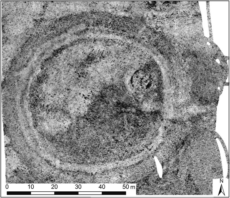
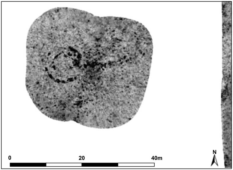
Traces of a second similarly sized structure are visible in the GPR data (especially 30–40cm time-slices) to the north east of the central structure (Structure 2, fig 9). Again, traces of an outer circle are visible, but not for the entire circuit. Other pits visible on the GPR may be anthropogenic or the result of extensive rabbit activity. That each circle has concentric elements might suggest circular post-built structures with external drainage gullies.
20–30cm GPR time-slice with Structure 2 clearly showing as a darker ring in the north east of the enclosure. GPR image: LBI.
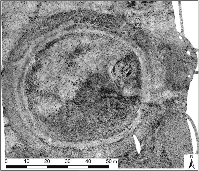
The interference shown in the magnetometry of the south-east quadrant of the enclosure (see fig 8) is almost certainly geological and suggests a fragmented bedrock, thus explaining the dryness of the southern arc of ditch, the deposits here draining more easily to the stream below. It is interesting to note that the core through the ditch encountered natural dense glacial till at its base in contrast to the core through the bank, which hit bedrock (see next section).
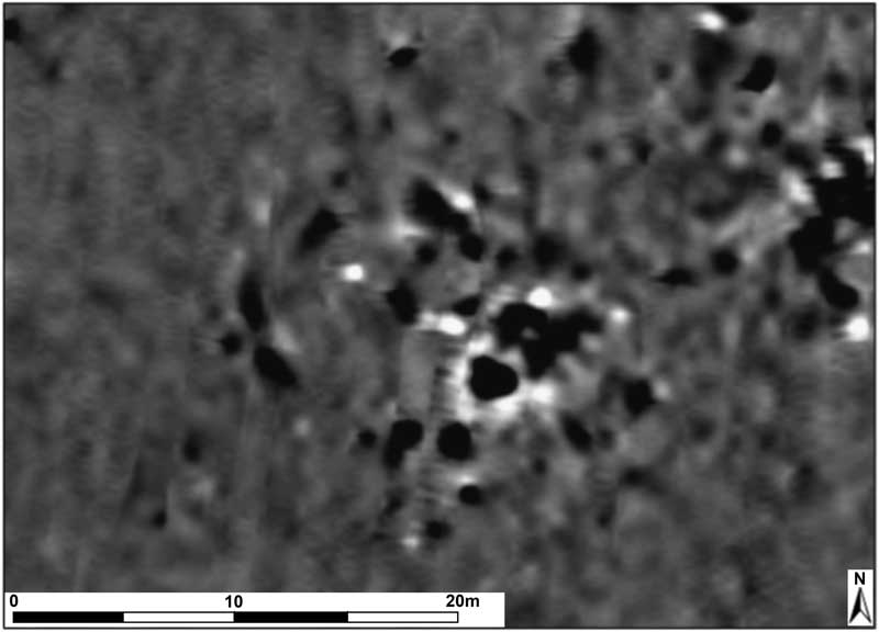
Another circular feature was located to the west of the enclosure comprising an arc of seven irregularly spaced pits (Structure 3, fig 10). The spring, responsible for the waterlogging of the ditch, rises on the eastern arc of this potential circle and once again makes it difficult to determine whether the circumference is complete. The arc measures some 11m in diameter with a large near-central pit. The GPR adds extra information (fig 11) and suggests that the magnetometry is detecting only the outer arc of a double circle with an inner circle or part circle, some 5m in diameter. This is visible from the 20–30cm to the 40–50cm time-slices. It suggests another circular structure with external drainage gully.
Structure 3: detail of magnetometry. Magnetometer image: LBI.

GPR image of Structure 3 (20–30cm time-slice). GPR image: LBI.

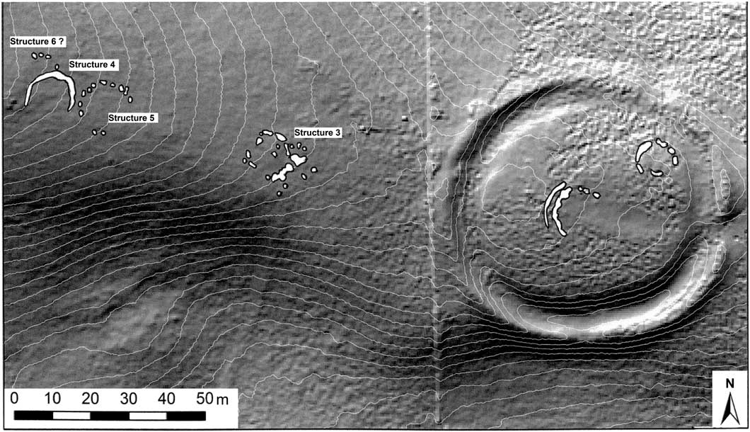
Noticed only during the data-processing in Vienna were two, possibly three, more post-hole circles located to the west-north-west of Structure 3 (fig 12). Structure 4 appears to be in the region of 10–11m in diameter and Structure 5 appears slightly larger at 12–13m. To the north of Structure 4, and overlapping with it, is an arc of pits possibly representing part of a sixth structure. Unfortunately, there are no supporting GPR data for this area. These circular structures, including that within the centre of the enclosure, form a linear arrangement running along the top of the ridge that the enclosure straddles and suggests that they were connected if not actually contemporary. They almost certainly represent later prehistoric settlement activity (fig 13).
Detail of Structures 4 and 5 to the west-north-west of the henge and possible settlement to the west-south-west. GPR image: LBI.

Circular structures running along the spine of the ridge. Magnetometer image: LBI.

Two stone-built structures are situated to the west-south-west of the henge in an area recorded as a potential settlement on the HER (see fig 12). This settlement does not seem as extensive in the geophysical survey as that recorded on the HER and there are no traces of the rectangular stone-built features recorded on the associated field sketch. No patterning was noted in the GPR survey and these anomalies possibly represent quarrying.
Traces of possible relict rectilinear field boundaries in the field to the west of the henge are visible on both the digital terrain model and the magnetometry (fig 14), the latter with the suggestion of a small circular structure in the north-east corner.
Possible relict field boundary and circular corner structure. Magnetometer image: LBI.

CASTLE DYKES CORING
Mike Allen
One core from the bank and a second from the ditch were taken from just to the north of the east-facing entrance (see fig 5) using a tracked window-sampling rig operating a petrol-driven percussion hammer driving a window sample of 80mm diameter. Undisturbed sediment was retrieved in sleeved cores.
The bank (Core 1) was cored at a location 15m north of the centre of the entrance, and 1.71m of sediment recovered (0–1.0m and 1.0–1.71m) encompassing the modern turf, henge bank and buried land surface above the parent material.
The ditch (Core 2) was sampled c 7m north of the centre of the entrance. A total of 2.95m of sediments above the parent material/bedrock was recovered in three blocks (0–1.0m, 1.0–2.0m and 2.0–2.95m). The sequence included the turf, tertiary silty loam, stone layer and soft grey waterlogged silts. The ditch deposits were not uniform and at least two or three locations met resistance, probably stony horizons, which were punctured.
Geoarchaeology and stratigraphy
The cores were cut open and the exposed faces cleaned and described following notation outlined in Hodgson,Footnote 9 and with Munsell colours recorded moist. In all cases, compression of the sediments by up to c 30 per cent was evident. Recovered (compressed) depths were compared to actual core depths and all measurements were adjusted accordingly for both descriptions and subsamples.
The bank was built on a weakly humic azonal (humic rendziniform) relict soil (at 165–171cm deep) that overlay the sandstone bedrock.Footnote 10 Two samples were taken for soil micromorphology by Professor Charles French.Footnote 11 This was overlain by what seems to be bank material with A horizon material (topsoil) incorporated (at 152–65cm). The lower bank or base of the bank comprised a greyish silt, possibly of alluvial origin, while the upper bank consisted of redeposited grey silt loam, largely B horizon (‘subsoil’) soil matrix, with some stones. Soil micromorphology suggested that the relict soil had been stripped of turf prior to the construction of the bank, while the lower bank material above this horizon comprised redeposited local soil, including some possible hearth sweepings.
The ditch was surprisingly deep.Footnote 12 Although 2.95m of deposit was recovered, the lower 0.53m was very dense and firm (almost solid) silt loam, with small and medium stones from several geologies. This probably represents a geological deposit such as a glacial moraine in deep fissures or voids in the bedrock. Above this a profile of 2.4m of ditch included a possibly waterlogged primary fill, silty secondary fill of which its upper part (at 101–61cm) was also possibly waterlogged just below a possible standstill zone/buried soil (at 62–101cm). A more mixed and gleyed tertiary fill and present soil represented the upper 0.51m of the ditch.
Waterlogged plant remains were encountered in the cores, and twenty-six bulk samples were taken and processed at 10cm contiguous intervals with care taken not to cross horizon boundaries.
The twenty-six bulk samples for waterlogged plant remains were processed by washover flotation onto 300μ mesh sieves and sieving onto 0.5mm and 4mm sieves. Sample size varied from 242g to 1,150g, with most samples being greater than 500g. There were few stones and very little, if any, residue in many samples.Footnote 13 Stones >4mm were examined, weighed, recorded and discarded. The finer stones, or residue >0.5mm, were weighed, recorded and retained. Three samples had no residue and residues were small (1g to 462g, but most about 100g or so).
Ten samples produced potentially waterlogged remains (see next section). Some of these, especially upper samples, may just be recent/modern plant root debris. Waterlogged remains, however, seemed present principally in the waterlogged secondary fills of the ditch (101–161cm) and in a highly localised part of the primary fills (209–219cm). Charcoal and charred remains were present in four samples; all in the potential buried soil in the ditch and the very upper part of the waterlogged secondary fills.Footnote 14 Significantly, both fine fragments of burnt (or cremated) bone were recovered from these samples, along with a miniature jet bead (see the section ‘The jet bead’).
Summary of the geoarchaeological and environmental significance
The ditch proved deeper than expected and contained a typical tripartite fill,Footnote 15 including a primary fill, secondary fill with stabilisation horizons, and tertiary, or upper, fill. The deposits are fine gained (predominantly silty), with few stones (though coring does not always sample stones representatively). Significantly, however, there were: zones of waterlogging; a zone of charcoal with burnt bone; and the recovery of a miniature jet bead. The fact that so many cultural remains were recovered, including very large quantities of charcoal, in relation to the very small sample sizes, indicates significant human activity during the later filling of the ditch. On top of this, the presence of a buried but truncated soil under the bank was noted.
The burnt bone fragments reported above are very small (<2mm and >0.5mm), are unidentifiable as to species and were recovered from two samples in the stabilisation horizon (82–92cm and 92–101cm) and one from near the top of the waterlogged secondary fills (111–121cm).Footnote 16
Radiocarbon dating
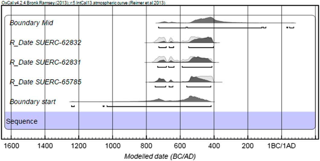
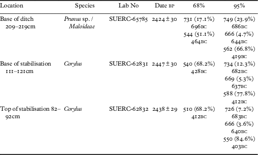
Two samples of Corylus roundwood charcoal were submitted. The first (SUERC-62831) was from just below the stabilisation horizon (depth 111–121cm) while the second (SUERC-62832) came from just above the same horizon (depth 82–92cm), from which depth the burnt bone fragments and the small jet bead were also recovered. These produced unexpected Iron Age dates. The question arose as to whether the stabilisation horizon could either have been or have masked a later prehistoric re-cut, so a third sample of Prunus sp./Maloideae from the base of the primary silts was also submitted (SUERC-65785). This produced similar results. Although clearly from different samples, the results are so statistically similar that they can be combined (X2−Test: df=2 T=0.5 (5 per cent 6.0)). This suggests that, as expected, the rapid primary fills had probably formed over a generation or so. The dates fall on the Iron Age plateau between roughly 700 and 400 bc, giving each a wide date range at 95 per cent probability (fig 15; table 1). If modelled in sequence using OxCal v4.2 and the IntCal 13 curve,Footnote 17 the date ranges can be refined and the weighting places the lower ditch silts to the stabilisation horizon probably in the sixth to fifth centuries bc (68 per cent probability). This is confirmed by the combined dates (546–409 cal bc; 76.2 per cent probability).
Modelled radiocarbon dates from the ditch sequence at Castle Dykes. Graph: Alex Gibson.

Modelled radiocarbon dates.

These dates were indeed surprising as Castle Dykes has the form of a classic single-entranced henge conventionally dated to the Late Neolithic or Early Bronze Age. While only small windows in the bank and ditch were examined, SUERC-65785 from the base of the ditch suggests either significant Iron Age remodelling or, more likely, that the enclosure is Iron Age in origin. This will be discussed below.
THE JET BEAD
Alison Sheridan
The bead was retrieved from the stabilisation horizon (82–92cm) identified in the core through the ditch. This is associated with a radiocarbon date of 550–403 cal bc (SUERC-62832), as discussed above.
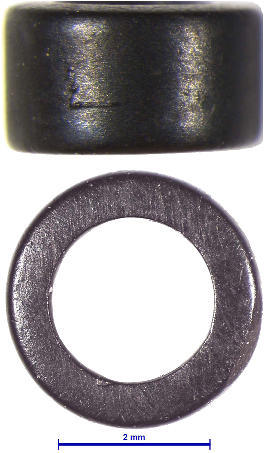
The bead is a minuscule, chunky, disc bead, circular in plan and cylindrical in profile, with a wide, centrally positioned thread hole (fig 16). Its external diameter is 3.7mm; perforation diameter 2.8mm; hoop width 0.9 mm; and thickness 2.3mm. The ends are neatly squared off and the perforation is parallel-sided and smooth. The outer edge has a low sheen, while the ends have a minimally higher sheen (possibly relating to bead-on-bead wear) and the interior of the perforation a markedly higher sheen; whether the last is due to thread-wear polishing the interior, or is a by-product of the drilling process, is unclear. There is no obvious trace of thread-wear to the ends of the perforation, which are crisp. A few very faint diagonal striations on the ends of the bead may relate to their grinding smooth following the bead’s detachment from a cylindrical preform, while a slightly deeper scratch on one end and a shallow scratch on the bead’s outer edge relate to minor ancient damage. The bead had been made with considerable skill: achieving such a narrow hoop without breaking the preform is difficult.
Microscope photo of the bead. Image: Alison Sheridan.

The bead is made from a black, compact material that is warm to the touch and which, under the microscope, does not have a ‘stony’ appearance, unlike cannel coal or shale. While the object proved to be too small for undertaking compositional analysis using X-ray fluorescence spectrometry (in the National Museums Scotland laboratory) and particle-induced X-ray emission (at the Louvre laboratory), nevertheless macroscopically and microscopically its colour and texture is characteristic of jet – more specifically, hard jet. This identification was confirmed by gemmologist and expert Whitby jet worker Sarah Steele. Given that the only significant deposit of high-quality jet in Britain is to be found on the coast around Whitby (around 85km to the east-north-east of Castle Dykes) and inland from there on the North York Moors, it seems most likely that the bead is made from Yorkshire jet.
There are two main periods when such minuscule (that is < 5mm in diameter) disc beads were made and used in Britain: the first extends from the Chalcolithic to around 1500 bc, Footnote 18 and the second is the Roman period, particularly (but not exclusively) the late third and fourth centuries ad.Footnote 19 While chunky disc beads resembling the current example are known from Early Bronze Age contexts (for example, Folkton barrow 245, East YorkshireFootnote 20), along with thinner versions, numerous Roman examples that closely match the Castle Dykes bead are known. The Roman examples include those from a ninety-two-bead necklace found at Walmgate, York;Footnote 21 here, their mode of manufacture (by grooving a cylindrical drilled preform and snapping off individual beads) is confirmed by the presence of longer cylindrical beads, notched to form two, three and four segments. A further Roman example is a delicate, five-strand necklace comprising several hundred beads, including numerous chunky disc beads, found on a female skeleton at Bainesse, on the site of the Roman fort and settlement of Cataractonicum (Catterick), North Yorkshire.Footnote 22
Given the radiocarbon dating evidence, indicating that the Castle Dykes earthwork was constructed during the Iron Age, it seems most likely that the bead is indeed of Roman date, quite possibly the late third or fourth century ad (although an earlier date in the Roman period cannot be ruled out). There is abundant evidence for a flourishing jet-working ‘industry’ of Roman date in the Whitby area,Footnote 23 and it is highly likely that the Castle Dykes bead is a product of that. Given its exceedingly small size, it could have percolated down through the waterlogged ditch-fill.
POLLEN SAMPLES FROM THE ENCLOSURE DITCH
Garry Rushworth
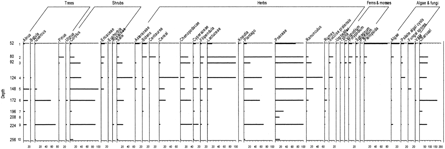
Standard palynological processing methods were used: disaggregation in 10 per cent KOH solution,Footnote 24 sieving through 160 micron mesh to remove coarse particles and on a six-micron mesh to remove solutes and fines, swirling on a clock-glass to gravity separate fine clastic particles. The samples were stained with safranine and mounted in Gurr Aquamount. The pollen was identified using Moore and Webb and the author’s own pollen type slide collection.Footnote 25 The description of pollen follows Bennett et al and the nomenclature is based on Stace.Footnote 26 The results can be seen in SM Appendix 2, table SM 4, and in fig 17.
Castle Dykes pollen diagram. Graph: Garry Rushworth.

The pollen sequence indicates environmental changes from woodland to open heathland with the possibility of clearance (possibly landnam practices?) indicated by amounts of charcoal and other burnt plant matter present in the pollen samples. Evidence for cereal cultivation appears at 172cm, low in the secondary silts, and there is also evidence of soil erosion, especially at 148cm in the secondary waterlogged fills, possibly as a result of forest clearance and soil disturbance by agricultural practices allowing for the greater influx of cereal pollen at this level.
These practices may also have contributed to the rise of algal and fungal spores from 148cm upwards by allowing for localised ponding to occur. Samples from low in the secondary or from the primary silts at depths 196cm, 208cm and 256cm had poor pollen representation. This may be due to the underlying Quaternary geology, probably till deposits.
THE CHARCOAL FROM THE DITCH
Dana Challinor
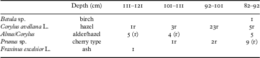
Four samples of charcoal were recovered from Core 2 through the ditch.Footnote 27 They are mainly from the upper secondary waterlogged silts (121–101cm) and the overlying stabilisation horizon (101–82cm). Three of the samples also produced burnt bone, with one containing the jet bead. A selection of random fragments were identified to provide a characterisation of the taxonomic composition of the charcoal assemblages and to select suitable pieces for radiocarbon dating. Standard identification procedures were followed, with fragments mounted in a sand bath for examination at high magnification.
Four taxa were positively identified: Betula sp., Corylus avellana L., Prunus sp. and Fraxinus excelsior L. (table 2). The Alnus/Corylus category is probably mostly Corylus, but not all fragments were confirmed at high magnification. Many of the fragments derived from roundwood, evidenced by the moderate to strong curvature of the rings. Any (near) complete stems were selected for radiocarbon dating.
Castle Dykes plant macro fossils.

Note: r=roundwood.
The type and character of the charcoal suggests that wood of relatively small diameter and age had been burnt and the species are typical of underwood or hedgerow types. The charcoal assemblage would be fairly typical for domestic type fires, where fuel was gathered from easily available branches in local woodland and margins.
CHARRED AND WATERLOGGED PLANT MACROFOSSILS AND INVERTEBRATE REMAINS FROM CORE 2
Wendy Carruthers and Enid Allison
The sampling and processing methods have been discussed by Allen above. The flots/washovers from the upper deposits containing no or very few waterlogged plant remains were dried (samples at 82–92cm and 92–101cm). Flots/washovers from lower samples were kept wet. The flots/washovers from thirteen consecutive samples from Core 2 were sent to Wendy Carruthers (WC) for analysis. Waterlogged and charred plant macrofossils were sorted by WC using an Olympus SZX7 stereoscopic microscope. Large charcoal fragments (see above) and invertebrate remains prepared by Enid Allison (EA) were extracted by WC and sent to the relevant specialists.
Results
Tables SM 5 (plant macrofossils; WC) and SM 6 (invertebrate remains; EA) in SM Appendix 2 present the detailed results of the analysis. Nomenclature and much of the habitat information for the plant remains follow Stace.Footnote 28 Other texts consulted for habitat and ecological information included Hill et al and Smith.Footnote 29 Identifications were made with the help of the authors’ reference collection and publications such as Cappers et al.Footnote 30 A key to habitat preferences and soils is provided at the bottom of table SM 5.Footnote 31 The small numbers of invertebrate remains were identified by EA and the nomenclature follows Duff.Footnote 32 Detailed sample descriptions are given in table SM 7.Footnote 33
Results of the analysis
A multidisciplinary approach to the analysis of waterlogged sediments provides a much higher degree of confidence in the interpretation of the deposits. Pollen provides a broad picture of the changing environment, while charred and waterlogged plant and other remains focus on the vegetation growing in the ditch, washing into the ditch from nearby and being deposited in the ditch due to human and livestock activities. Invertebrate evidence can help to provide information about land use in the immediate area, such as the grazing of livestock, and, using information about specific food plants, it can provide support to plant macrofossil interpretations.
The earliest evidence from the primary ditch-fill indicated that the local environment was primarily open and subject to human disturbance from the time the first sediments accumulated. However, some woodland or scrub may have survived in the area, since hazel and oak was frequent at 224cm (see the section ‘Pollen samples from the enclosure ditch’) and some poorly preserved wood fragments, including twigs and possible alder leaves, were recovered from the two lowest samples in the ditch. Sample 219–229cm contained only around a fifth of the number of plant remains as sample 209–219cm, perhaps because it may have been partially composed of clean sediments from the eroding ditch sides in the early stages of its use. Sample 209–219cm contained a diverse assemblage of grassland and disturbed ground taxa with a few aquatics indicative of shallow water. A date of 562–419 cal bc (66.8 per cent probability; SUERC-65785) was obtained from a fragment of Prunus sp./Maloideael from this sample. Sedges and rushes were growing along the margins of the ditch. Both samples contained frequent cladoceran ephippia, indicating that standing water was present for at least some of the year, and suggesting that nutrient-enrichment was taking place. This was confirmed by the identification of fragmented sclerites of a scarabaeid dung beetle (Aphodius). These beetles are primarily associated with herbivore dung, although some species will less commonly exploit foul vegetable material and foul occupation waste.Footnote 34 Given the small size of the invertebrate assemblages in the Castle Dykes samples, the records are likely to be significant. The presence of grazing livestock was also supported by the dominance of plant species of nutrient-enriched soils, such as common chickweed and stinging nettle. Despite the numerical dominance of nitrophilous taxa, open grassland was likely to have been the dominant vegetation type overall, perhaps with patches of trampled and disturbed soil due to livestock activity. The thin-walled seeds of grasses do not survive well in anoxic deposits and would seldom have survived to set seed if heavily grazed, so they are under-represented in this type of deposit.
The presence of plants of both nutrient-enriched soils and nutrient-poor soils (cuckoo flower, mouse-ear and bracken) in sample 209–219cm may be because nutrient-enrichment was only taking place on one side of the ditch. This sort of situation could have occurred if livestock were restricted to only one side of the ditch, or if human activities causing nutrient-enrichment, such as feasting, cooking and defecating, only took place in part of the site. Terrestrial beetles included leaf beetles associated with grassy habitats and a possible synanthropic element: Cercyon haemorrhoidalis is associated with dung deposited in the open and foul occupation waste, and Gyrohypnus fracticornis is typically recovered from man-made habitats with decomposing plant litter, though it may also occur in natural habitats. Although no definite plant macrofossil or pollen evidence of cultivation was found in these lower deposits, the presence of traces of possible black mustard seeds (Brassica cf nigra) in the two earliest samples as well as sample 161–71cm could represent a cultivated crop, since it is occasionally found in abundance on Iron Age sites. Over 2,000 black mustard seeds were recovered from a Middle Iron Age pit at Biddenham Loop, Bedfordshire,Footnote 35 and frequent seeds were found in Iron Age four-posters at Truro CollegeFootnote 36 and Chester.Footnote 37 It is the most pungent of the mustards and has been used as a condiment and a source of oil at least since Roman times. It also has medicinal uses, either in poultices or for its antibacterial properties. Up to 30 per cent of a black mustard seed consists of oil. Since black mustard is thought to be a native plant it is possible that the plants were growing naturally as a weed of waste ground and disturbed soil.
The next two samples (199–209cm and 171–84cm) contained only traces of waterlogged and charred plant remains, and very little pollen (see the section ‘Pollen samples from the enclosure ditch’) suggesting that the ditch had dried out during this period, perhaps due to climatic factors. Moderate amounts of cereal pollen occur from 172cm upwards, together with frequent burnt material and possible signs of erosion, though cultivation and burning may have been taking place some distance from the ditch as a few large identifiable charcoal fragments (>3mm) were only present from around 111–21cm and upwards (see the section ‘The charcoal from the ditch’).
The presence of frequent ephippia and reasonable numbers of waterlogged plant and invertebrate remains in the next two samples (161–71cm and 151–61cm) indicates that the sediments were once again subject to anoxic conditions. However, only a single seed of an aquatic plant was present (a water-starwort nutlet) and only two ditch-side marshy taxa were recovered (a rush seed and sedge nutlet), suggesting that the ditches may have been kept clear during this period. The presence of remains from water beetles confirmed that the ditch held water at this time, but perhaps the grazing pressure increased so that the vegetation was unable to set seed. Alternatively, vegetation such as rushes and sedges may have been cut and collected for use in the house or for fodder, but this explanation would not account for the absence of floating aquatics such as duckweed. In other aspects, the plant assemblages from these two samples closely resembled those of the primary deposits in the range and frequency of plant taxa present.
Sample 141–51cm was unique in containing a shoot tip and a few fruits from heathland taxa (heather and heather/ling). The pollen results showed that Ericaceae first appeared at 148cm and continued to be present in the samples above (see the section ‘Pollen samples from the enclosure ditch’), but heathland may have been located some distance from the ditch as no ericaceous plant macrofossils were found higher up the profile. It should also be remembered that the soil samples were small in volume (mostly around 600ml), so the plant macrofossil assemblages cannot be expected to be fully representative of the local flora. It is also possible that the material was brought in as fodder or fuel, or that the livestock had been grazing on heathland before returning to the site and introduced the remains in dung or trample. In other ways, this sample was very similar to the next two samples (131–41cm and 121–31cm). All showed some probable signs of over-grazing, as thistles, greater plantain, buttercups and selfheal were recorded. Buttercups and thistles become frequent in over-grazed pastures and greater plantain can thrive in areas of trampling. Selfheal is an indicator of impoverished soils and is common in poor grasslands. Two fragments of dung beetles were present, suggesting that, in addition to the impoverished, over-grazed grassland, some areas were enriched with dung (as demonstrated by the high nitrophilous weed counts). The ditch continued to hold water, as indicated by frequent ephippia, a higher representation of aquatic beetles than before and a sudden rise in sweet-grass (Glyceria sp.) in sample 141–51cm. Sweet-grass can become dominant in shallow, muddy ditches. Since Glyceria maxima contains compounds with cyanogenic potential,Footnote 38 it is likely that the livestock found it distasteful, perhaps allowing it to thrive in the ditch. Although uncommon, there are some records of cattle-poisoning fatalities from this taxon.
From sample 121–31cm upwards, the ditch appears to have gradually become silted up to the extent that sedges increased, nettles dominated and brambles became established nearby. All of these taxa produce either tough-coated or abundant seeds, so the remains are more likely to survive in drier sediments. The absence of ephippia or other aquatic remains from level 92–101cm upwards and the reduction in the diversity of plant taxa at this point suggests that the ditch was no longer permanently waterlogged, presumably due to its having become silted up. Traces of possible charred food waste were found in the two uppermost samples (92–101cm and 82–92cm) consisting of two fragments of hazelnut shell (Corylus avellana) and a hulled barley grain (Hordeum vulgare). Since the sizes of the ditch samples were small, the recovery of sufficient charred plant remains to provide information about arable cultivation and diet would not be expected.
Iron Age radiocarbon dates from the middle and bottom of the ditch sediments demonstrate that the long sequence of environmental evidence from the ditch relates to activities taking place probably from the sixth to fifth centuries cal bc, but possibly from the seventh to fourth centuries. Comparable sites do not exist in the area, although occasional Iron Age hillforts and enclosures from other parts of the British Isles have produced waterlogged plant and invertebrate assemblages from ditch sediments. The Iron Age ringwork at Arbury Camp, radiocarbon dated to the fourth to second centuries bc, produced mixed assemblages from one ditch that were dominated by grassland taxa with some aquatic plant species but no shrubby taxa and less evidence for nutrient-enriched soils than at Castle Dykes.Footnote 39 Later sampling of internal features and ditch terminals found more evidence of nitrophilous plant taxa, revealing areas with higher levels of human activity and some scrubby taxa.Footnote 40 Very similar results have been found in the bottom of Iron Age enclosure ditches, with open grassland being the principal vegetation type but with varying levels of nutrient-enrichment, scrubby taxa and aquatic plants. There are often few remains of economic plants in this type of ditch, as was the case at Castle Dykes.
DISCUSSION
The extensive geophysical and topographic survey was designed to investigate the environs of the ‘henge’ as well as the monument itself. The results, though limited, located internal and external features. Had no dating materials been obtained, the central internal setting may have been interpreted as a timber or pit circle, both common in Late Neolithic and Early Bronze Age henges, but the dating of sites by morphology alone is dangerous and this has certainly been demonstrated at Castle Dykes. Although coring a substantially re-cut section cannot be ruled out, Iron Age dates from the top and bottom of the primary silts and the morphology of the internal structures make it virtually certain that this enclosure is not Neolithic. The ‘pit circles’ with their traces of external drip trenches can also now best be interpreted as later prehistoric roundhouses: they are fairly uniform in size and, lying on the crest of the spur, they share a common topographical setting with the external sites. The construction of these timber structures, at least within the enclosure, may be contemporary with the woodland clearance noted in the basal pollen assemblage and the grassland assemblage in the plant and insect report above (see the section ‘Charred and waterlogged plant macrofossils and invertebrate remains from Core 2’). It suggests the settlement and exploitation of an environment that already had substantial cleared areas. Cereals as well as plant and insect microfossils that thrive in nutrient-rich environments attest that a mixed economy was being practised at the site.
The internal ditch of Castle Dykes is not, of course, without parallel in an Iron Age context. ‘Banjo enclosures’, usually interpreted as stock enclosures, often have internal ditches and external banks, though their circuits are usually less regular than Castle Dykes.Footnote 41 Interpreted as stock enclosures by virtue of their funnel-like approaches and lack of internal structures, the internal ditch at these sites may have acted as not just a means of containment, but also as a convenient drainage facility in an attempt to keep the interior relatively dry. The outer bank itself, especially if surmounted by a hedge, would have been sufficient to act as a means of stock control. This functional explanation may also be relevant at Castle Dykes, where the ditch is presently waterlogged in the northern arc, yet better drained in the southern. The spring responsible for this waterlogging may be post-Iron Age in origin, especially given the proximity of Structure 3, but it nevertheless demonstrates the efficacy of the ditch as the interior is generally dry (as demonstrated by the rabbit activity). Castle Dykes was used at least partly for stock and/or other agricultural activities, as attested by the plant species favouring nutrient-rich soils and fragments of fauna such as dung beetles from the ditch silts. The presence of taxa preferring both nutrient-rich and nutrient-poor conditions in sample 209–19cm is suggestive of animals and/or humans using only one side of the enclosure ditch, presumably the interior. This might explain the desirability of a drainage ditch as well as the slight hollow leading into the interior from the entrance, which probably represents scarring resulting from ground surface poaching through continued use by people, animals and vehicles.
Circles of earth, timber and stone have, however, been demonstrated to have had a longevity that lasts from the later Neolithic to the later Bronze Age, and appear in a sequence that seems to start small and simple, to develop into the large (and in the case of timber examples, multiple) circles of the final Neolithic and then trail off in size and complexity towards the Middle and Late Bronze Age.Footnote 42 The Late Bronze Age cremations and the early historic burials within henges such as that at North Mains, Perthshire, are well known.Footnote 43 The use of stone circles, recumbent stone circles and Clava Cairns in Scotland can also be seen to extend into the Late Bronze Age,Footnote 44 and Bradley has recently discussed the use and re-use of Scottish stone monuments not just into the Late Bronze Age but even further.Footnote 45 He discusses the unexpected discovery of Iron Age roundhouses within the recumbent stone circles of Strichen and the Candle Stane and the Roman–Iron Age re-use of other stone monuments in Scotland, suggesting the importance of these monuments in later landscapes. This point had already been made by Hingley with relation to the Iron Age manipulation of chambered tombs going as far as the later prehistoric mimicking of styles of Neolithic pottery found within those tombs.Footnote 46 This was not seen as a desecration of these monuments, but rather an attempt ‘to project the identity of the lineage through an association with the ancestors’.Footnote 47 Barrett made a similar point when interpreting monumental change at the end of the Bronze Age, and stated that in the Iron Age ‘the past was … represented in the landscape … and was still an essential component of the landscape, acting as an horizon to which the acts of inhabitation could refer’.Footnote 48 Hingley later also discussed later prehistoric activity at earlier sites in other parts of Britain and saw this as an ‘active manipulation of the past’, though he was keen to point out that this need not have represented ‘part of a standard pattern’.Footnote 49
Manby has also drawn attention to the similarity between henges and his type 1 Late Bronze Age ringworks found increasingly in eastern England from Essex to Yorkshire.Footnote 50 The inner circuit at Thwing, for example, has an internal ditch, external bank and two opposed entrances, but the radiocarbon dates span the fourteenth to ninth centuries cal bc. The double-entranced North Rings at Mucking also bears a strong resemblance to Castle Dykes, with a trackway leading in from the east-facing entrance, a near-central post-hole-defined structure and a second hard against the inner edge of the ditch in the north-east quadrant. Slightly later than Thwing, spanning 1020–410 cal bc, these dates are likely to be termini ante quos as they come from the secondary fills of the ditch.Footnote 51
The use and re-use of these circular monuments, though remarkable for the timespan involved, even if the activity is episodic rather than continuous, can be easy to understand as developing over time from one period to the next on a monument of continued visibility. Less easy to explain are sites of Neolithic and Bronze Age ‘type’ that appear to be much later foundations: sites that were apparently founded in the later Bronze Age or Iron Age without any ostensible continuity from earlier periods, such as would appear to be the case at Castle Dykes.
At Ferrybridge, West Yorkshire, there is an opposed entranced inner ditch with an outer bank, with apparently three gaps through the latter. Manby attributes the finding of a La Tène (third century bc) sword scabbard from the inner double-entranced ditch as a result of cleaning and re-cutting;Footnote 52 however, while this may seem logical, no evidence for such a re-cut was found in the limited excavation.Footnote 53 Roberts discusses several phases of bank construction with hiatus periods between some of the phases and quotes radiocarbon dates of the late fourth/early third millennium for the bank’s initial construction. These dates, however, are by no means secure. Charred grain from a humic layer over the phase 1 bank probably dates to between the thirty-fourth and twenty-ninth century cal bc, but this is rather early for double-entranced henges,Footnote 54 and the sample was not a deliberate deposit. Given the amount of potentially contaminating Neolithic and Bronze Age activity in the area, the sample could easily be an accidental incorporation. Added to this, Neolithic and Early Bronze Age artefactual evidence is absent from the site. The phase 2 bank is dated from a similar context by two samples of oak charcoal that are not statistically similar and which date to between the thirtieth to twenty-eighth century cal bc and the twenty-sixth to twenty-third century cal bc respectively,Footnote 55 again suggesting that they do not date an archaeological event but rather represent accumulated charcoal accidentally incorporated into the bank. Not only does the scabbard come from the base of the broad shallow ditch, it is immediately overlain by silts containing Roman material. Given the small-scale nature of the excavation, however, definitive dating cannot be offered, and the central area remains unexplored.
The small single-entranced enclosure at Pict’s Knowe in Dumfries and Galloway had a broad and shallow ditch that enclosed an area some 22m in diameter.Footnote 56 The excavator interprets dates spanning the twenty-fifth to the twentieth century cal bc as providing termini post quos for the construction of the henge and a re-cut in the ditch may relate to later Iron Age embellishment.Footnote 57 The pre-bank dates, however, come from peat formation and Thomas suggests that, in the absence of a buried soil, the peat was forming as the bank was built. While this is obviously a possibility, the soil micromorphology analyses from both Castle Dykes and the Bronze Age single-entranced henge at Yarnbury, North Yorkshire, indicate that at both sites the topsoil had been stripped before the construction of the bank,Footnote 58 and a similar scenario at Pict’s Knowe seems likely. Dates from waterlogged wood from the primary ditch-fill span the fourth century cal bc to the first century cal ad and use of the site continued well into the Roman Iron Age.Footnote 59 Albeit smaller than Castle Dykes, Pict’s Knowe bears strong comparison.
A review of henges in Wales also identified later prehistoric enclosures that had been identified as henges on morphological grounds.Footnote 60 In a non-defensive position straddling a spur, the oval externally ditched enclosure at Castell-Garw, Dyfed, despite rumours of internal stone settings and evidence for pre-enclosure Neolithic activity, returned first millennium radiocarbon dates from below the bank.Footnote 61 The same result befell the hillslope enclosure at Dan-y-coed, Dyfed, datable to the Late and Roman Iron Ages.Footnote 62 A penannular ditched enclosure at Tytandderwen, Gwynedd, initially interpreted as a henge, once again produced late first millennium radiocarbon dates,Footnote 63 though the site produced no evidence for a bank. A site that appears to have come full circle is Castell Mawr, Dyfed, which lies close to the source of the Stonehenge bluestones. This oval earthwork 160m east–west by 100m north–south was originally interpreted as a later prehistoric enclosure. The site has an external bank and an internal ditch some 10–15m wide and 3m deep with two opposed entrances, and for this reason, following survey, was re-interpreted as a possible henge.Footnote 64 Recent exploratory excavation at the site has, however, confirmed its later Bronze Age date.Footnote 65 Bayvil Farm, Dyfed, also suspected to be a ‘henge’, proved to be a later Bronze Age foundation,Footnote 66 and, indeed, it was the henge affinities of this site and Castell Mawr that prompted the excavations. This has lead Parker Pearson to review later Bronze Age ringworks in Wales, thus complementing the work in eastern England as discussed above and concluding in agreement with both Hingley and Barrett that ‘the majority … of Late Bronze Age ringworks appear not to have had any local Neolithic monument to inspire their construction. Even so, the similarity of form between ringworks and henges is close enough to suppose that ringworks referenced an ancient Neolithic past’.Footnote 67 This may not be the case at Llandegai (see below), but may be pertinent to Castle Dykes.
At Castell Bryn-Gwyn, Anglesey, Middle Neolithic activity associated with Impressed Wares centred on a circular externally ditched enclosure that received major modifications in the later prehistory.Footnote 68 These several modifications transformed the site into a small ring-fort with a V-sectioned ditch and stone-faced wall. It may be that, in such a case, the location may have been paramount to the Iron Age occupants rather than the earlier monument, as the ‘henge’ was rendered unrecognisable by the later modifications. That said, it must be remembered that the alterations and modifications may have added to the history, biography and mythology of the site, serving to justify the occupants’ claim to the area. Not so at Llandegai henge A, Gwynedd, a ‘henge monument’ with which the present writer (AG) has never felt comfortable and which on closer inspection was not re-used in the later Bronze Age as initially suspected, but rather was almost certainly of later prehistoric foundation.Footnote 69 With an external ditch and internal bank, this single-entranced enclosure is perfectly circular. The bank, which was formed from only part of the excavated ditch material, seals a Neolithic soil; however, there are traces of a relict turf-line between the soil and the bank, suggesting that the henge may have been constructed at a considerable time after the soil had become sealed. The ditch was 10–11m wide and some 3m deep and rapid primary fills stabilised at 1.2m from the base. Residual pottery from these rapid basal silts was interpreted as Fengate Ware, while a radiocarbon date spanned the thirty-sixth to twenty-ninth centuries cal bc. Unfortunately, the integrity of this date can be seriously challenged,Footnote 70 as it was obtained from ‘scattered charcoal’,Footnote 71 and, as with Ferrybridge above, given the extent of Neolithic and Bronze Age activity in the surrounding area, the charcoal and pottery may well represent washed-in material from features or soils eroded from the ditch edge. Above this stabilisation layer, radiocarbon dates suggest a slow silting process starting around c 800 cal bc. This date may be nearer the construction of the site than is the residual pottery and charcoal: after all, the basal ditch silts are reported to have formed ‘rapidly’ and, given the gravel environment, this may have taken no more than one or two generations. The only Neolithic features on the site are either sealed by the bank (and therefore are earlier, probably much earlier) or have no stratigraphic relationship to the perimeter at all and are focused largely on the external cremation cemetery. Instead, the interior of henge A is filled with later prehistoric features such as four-posters and at least two roundhouses, and the similarity to the internal arrangements at Castle Dykes is obvious. The case for a later prehistoric date for Llandegai A seems undeniable. Contrary to Parker Pearson’s observation noted above, there does appear to be the potential for Neolithic inspiration at Llandegai A in terms of the nearby double-entranced, internally ditched henge B, which is almost certainly of later Neolithic/earlier Bronze Age date,Footnote 72 and was presumably still visible as an earthwork in the later Bronze Age as attested by the pottery in the secondary ditch silts. The relevance of this potential inspiration may, however, be questioned as Llandegai A is significantly different in its component parts (single rather than double entrance, internal rather than external bank, external rather than internal ditch) to suggest that henge B may have had limited, if any, influence on the design or construction of the later monument.
In Cornwall, excavators were equally surprised by the dates from the suspected henge at Hay Close, St Newlyn East.Footnote 73 This 60m diameter circular enclosure had an internal ditch and external bank, and, like Castle Dykes, lay on a sloping spur. Pottery from the site was almost totally Iron Age and Romano-British and a radiocarbon date from the ditch suggested the foundation of the site in the eighth to fifth centuries cal bc (95 per cent probability), therefore broadly contemporary with Castle Dykes. The Hay Close ditch was then re-cut in the early post-Roman period. Jones identifies other Cornish henge-like enclosures that can be dated to the Iron Age, such as the internally-ditched enclosure at Camelford dated by radiocarbon to the first century bc/ad. Traces of occupation were absent, which led Jones to interpret the site as ceremonial.Footnote 74 A triple-ditched enclosure at Tremough was also devoid of settlement evidence, and at least one of the ditches had a stone-built bank against the outer edge. Traces of what was probably a substantial post was found in the interior and again a ceremonial function was suggested.Footnote 75 Jones goes on to reference the royal sites in Ireland, to which we shall return.
We have already seen above that the use and re-use of earlier sites in the later Bronze Age and Iron Age in some cases appears to be a clear case of continuity. In other cases, it seems that emulation is being practised, and this is more difficult to understand. In Ireland, the Late Bronze Age and Iron Age manifestations of henges (Lugg, Co Dublin) and timber circles (Raffin, Co Meath, Haughey’s Fort, Co Armagh, Knockaulin, Co Kildare, and Navan, Co Armagh) have been known for some time and a case was previously made for continuity,Footnote 76 though the Late Iron Age dates at Navan and Knockaulin did stretch the argument. A case was subsequently made for a reinvention of timber circles; a tradition that possibly survived in the oral record, to be resurrected in the Late Iron Age as Ireland suffered a climatic down-turn and was immersed in a period of economic stress.Footnote 77
Warner examined the Iron Age internally ditched enclosures at Navan, Tara (Co Meath) and Knockaulin.Footnote 78 Tara encloses the Mound of the Hostages, a Neolithic passage grave with secondary Bronze Age activity,Footnote 79 but also, as with Navan, contains smaller circular monuments with either internal ditches or with ditches between internal and external banks.Footnote 80 Similarly shaped enclosures, such as the three sites that form the Cléonfherta, are also found close by, though outside the main enclosure at Tara. Using the classical Irish literature, Warner suggested that they were to contain Otherworld forces: they were hillforts in reverse, designed to keep danger in rather than out. There is a degree of evidence to suggest that the mounds and circles that these sites contain may have been seen as portals to the Otherworld; the idea of such portals (caves, mountains, springs) being a concept common to many world mythologies. The idea is attractive and would explain the ditch/bank arrangement of both these royal sites and conventional Neolithic henges, but it does not explain the resurgence or reintroduction of internally ditched enclosures. Whatever the reason – and arguments are far from conclusive – there does seem to be a clear continuity of embanked enclosures from the Neolithic to the Late Bronze Age in Britain and Ireland,Footnote 81 and a later resurgence of circular non-defensive enclosures in the Iron Age.
Of course, landscape features are just that – features surviving in the landscape – and they often attract their own mythologies, as witnessed by the names of many prehistoric monuments: the Twelve Apostles stone circle, West Yorkshire; the chambered tombs at Hetty Pegler’s Tump, Gloucestershire, and Wayland’s Smithy, Oxfordshire; and the passage grave at Barclodiad y Gawres, Anglesey (the apronful of the giantess), to name but four. There is, therefore, every reason to assume that Neolithic earthworks would have been observed in the Iron Age and possibly ‘explained’ by legend and mythology, as suggested by Barrett.Footnote 82 They may even have been revered by revisiting and by the renewing of rituals or, conversely, they may have been avoided altogether as sites of potential danger. They may have signalled rights to ancestral territories, perhaps physical remains around or upon which mythological lineages were constructed. A case has been made for the deliberate slighting of Neolithic palisade enclosures by the Roman armies of occupation some two to three millennia after they had been constructed.Footnote 83 This pattern is a consistent one and suggests that the locales of these long-gone wooden enclosures still had some Late Iron Age importance, even if little in the way of Iron Age archaeological evidence remains. Perhaps the sites were indeed perceived as Otherworldly and inhabited by ancestral ghosts or even genii loci: unnamed yet potentially powerful spirits. Were these forces to be considered more powerful at some locations than at others, then an element of monumental emulation may also have happened. This may be the case at Castle Dykes, Ferrybridge and Pict’s Knowe – the last two, in particular, on the sites of earlier activity. This may be a way of referencing a mythological past, as has been suggested for the deposition of earlier artefacts at some Iron Age sites and that ‘Iron Age people were using locales, geographical orientation and objects to communicate with their origins’.Footnote 84 It is clear from the discussion above, however, that while the past clearly was referenced in some cases, it does not seem to have been in all. There may be a purely practical explanation for some internally ditched enclosures and a superstitious, religious or ancestral reason for others. There is no single universal mechanism or single explanation for the perceived phenomenon that may have more to do with our modern need to categorise and classify monuments from our distant past.
ACKNOWLEDGEMENTS
The author is grateful first and foremost to the landowners, Mr D Wood and Mr D Dinsdale, for their permission to survey and sample and for their interest throughout the project. The work was facilitated by generous research grants from the Royal Archaeological Institute and the Society of Antiquaries of London. A derogation from Natural England and Scheduled Monument Consent from English Heritage were obtained through the respective good offices of Margaret Nieke and Neil Redfern. Thanks are extended to the team at the Ludwig Boltzmann Institute, for collaborating in the project and for taking time to discuss and interpret the results in Vienna, and to the various specialists who provided full and timely reports. The author is also grateful to the anonymous referees who provided very positive feedback. Charles French would like to thank Tonko Rajkovaca of the McBurney Geoarchaeology Laboratory, Department of Archaeology and Anthropology, University of Cambridge, for making the thin section.
SUPPLEMENTARY MATERIAL
The following supplementary material can be found online at https://doi.org/10.1017/S0003581518000628
ABBREVIATIONS AND BIBLIOGRAPHY
Abbreviations
- CBA
Council for British Archaeology
- HER
Historic Environments Record
- LBI
Ludwig Boltzmann Institute