1. INTRODUCTION
Signals received from navigation satellites experience delay or distortion due to several types of error source. Signal delay is a typical error component that depends on the signal path from a satellite to a user, and it mainly occurs in the ionosphere and troposphere. The speed of propagation of Global Positioning System (GPS) signals in the troposphere is lower than that in free space and, therefore, the apparent range to a satellite appears longer, typically by 2·5–25 m depending upon the satellite elevation angle (Misra and Enge, Reference Misra and Enge2011. P.169).
The ionospheric zenith delay (i.e., the path delay in the zenith direction) typically varies at mid-latitudes from about 1–3 m at night to 5–15 m in the mid-afternoon (Misra and Enge, Reference Misra and Enge2011. P.165). The ionosphere error is affected by solar activity, which makes the size of the error differ greatly between day and night, as well as between seasons (Misra and Enge, Reference Misra and Enge2011). For error components that occur in the signal propagation medium such as the ionosphere and troposphere, the magnitudes are almost equal at two nearby ground sites. Differential GPS (DGPS) is a method that removes these errors to enhance positioning accuracy. DGPS is a type of ground-based augmentation system that uses correction messages received from a nearby base station. Based on the accurate coordinates of a reference site, one can calculate error components contained in GPS measurements. Based on these errors, corrections to the pseudorange measurement can be computed and broadcast to the user. The user thus gets an accurate location by integrating the correction messages in the positioning algorithm.
Traditional Single-Reference-station DGPS (SR-DGPS) corrects positioning errors by using correction messages received from one reference site. When a user is close to a reference station, positioning accuracy is improved by removing similar error components using the correction messages. Positioning accuracy is approximately 1–3 m in this case. However, this method has a limitation in that the spatial correlation of errors decreases as the user moves away from a reference station. This leads to a degradation in positioning accuracy (Monteiro et al., Reference Monteiro, Moore and Hill2005).
Multi-Reference-station DGPS (MR-DGPS) was designed to overcome this limitation. In this approach, a user receives correction messages from multiple base stations, interpolates them to derive the best optimal value at a specific location and applies the results to DGPS positioning (Lachapelle et al., Reference Lachapelle, Alves, Fortes and Cannon2000; Retscher, Reference Retscher2002; Bakuła, Reference Bakuła2007). Thus, even with greater baseline length, relatively accurate positioning can be achieved compared to SR-DGPS. However, a certain number of correction messages are needed, and it can be difficult to process them simultaneously. In addition, if the user is located outside an available network, errors due to extrapolation may degrade the positioning accuracy.
We devised a new method to improve positioning accuracy by considering the satellite elevation angle in SR-DGPS positioning. First, we analysed correlations between satellite elevation angle and Pseudo-Range Correction (PRC). Then a simple model is introduced that uses elevation angles at the reference site and the user to obtain a new PRC at the user location. Finally, the model is validated by comparing positioning accuracies with those from SR-DGPS and MR-DGPS.
2. CONCEPT OF DGPS POSITIONING
2.1. Single-Reference-Station DGPS (SR-DGPS)
DGPS positioning can be used when two receivers observe four or more satellites at the same time. One receiver is located at a base station whose precise position is known in advance based on geodetic surveys. This reference receiver broadcasts PRC and range rate correction messages. Users receive the correction messages and use them to correct pseudorange measurements collected at their location.
The pseudorange correction for satellite s at reference epoch t 0 is defined by the relation (Hofmann-Wellenhof et al., Reference Hofmann-Wellenhof, Lichtenegger and Wasle2008. P.170):
 $$PRC^{\,s}(t_0)=\rho_r^s (t_0)-R_r^s (t_0)=-\Delta \rho_r^s (t_0)-\Delta \rho ^s(t_0)-\Delta \rho_r (t_0)$$
where the subscript r denotes the reference station. The geometric range
 $\rho_{r}^{s} \lpar t_{0}\rpar $
is obtained from the known position of the reference station and the broadcast ephemerides, and
 $R_{r}^{s} \lpar t_{0}\rpar $
is the measured quantity (Hofmann-Wellenhof et al., Reference Hofmann-Wellenhof, Lichtenegger and Wasle2008. P.170). The term
 $\Delta \rho_{r}^{s} \lpar t_{0}\rpar $
denotes range biases depending on the terrestrial base position and satellite position as well (e.g., radial orbit error, refraction effects), the range bias
 $\Delta \rho^{s} \lpar t_{0}\rpar $
is purely satellite dependent (e.g., effect of satellite clock error), and the range bias
 $\Delta \rho_{r} \lpar t_{0}\rpar $
is purely receiver dependent (e.g., effect of receiver clock error, multipath) (Hofmann-Wellenhof et al., Reference Hofmann-Wellenhof, Lichtenegger and Wasle2008. P.170). Since
 $R_{r}^{s} \lpar t_{0} \rpar $
is a distance that includes signal delays, it is larger than
 $\rho_{r}^{s} \lpar t_{0}\rpar $
, and PRC
s
(t
0) normally has negative values. A corrected pseudorange
 $R_{u}^{s} \lpar t\rpar _{corr} $
at the user receiver can be obtained by adding the received PRC value to the code pseudorange observable
 $R_{u}^{s} \lpar t\rpar $
generated at the user location:
 $$R_u^s (t)_{corr} =R_u^s (t)+PRC^s(t)$$
2.2. Multi-Reference-Station DGPS (MR-DGPS)
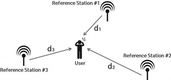
MR-DGPS combines correction messages from more than one base station to generate an interpolated PRC at the user location, as shown in Figure 1. This method allows the user to obtain accurate coordinates even when reference stations are far away. Inverse Distance Weighting (IDW) is one of the most popular methods and is given in Equation (3). IDW is a simple but powerful interpolation method that can generate PRC for the user location by applying weights according to the reciprocal of the baseline length to each base station.
Schematic diagram of multi-reference DGPS: The user receives concurrent PRC messages from multiple base stations and considers distances to each base station.

In Equation (3),
 $PRC_{u}^{k}$
is the interpolated PRC of satellite k at the user location, while
 $PRC_{u}^{k}$
indicates the PRC of the corresponding satellite at base station r. d
r
is the baseline length between the reference station r and the user, and its reciprocal is used as a weight w
r
. N is the number of base stations used for interpolation.
 $$PRC_u^k =\displaystyle{{\sum_{r=1}^N {PRC_r^k w_r}}\over{\sum_{r=1}^N {w_r}}};\quad\quad w_r =\displaystyle{{1}\over{d_r}}$$
3. PRC GENERATION BASED ON ELEVATION ANGLE
In SR-DGPS, the user receives correction messages from a certain base station. To achieve high accuracy with PRCs from a distant reference site, the PRC messages should be modified to make them appropriate for the user location. We used satellite elevation angles to design a new PRC generation model. The atmospheric delay is a major contributor to the magnitude of the PRC and is larger at low elevation angles. As the satellite elevation angle decreases, the path that the GPS signal has to pass through in the atmosphere increases substantially. Therefore, we examined the relations between PRC and the elevation angle.
To examine the changing pattern of PRC with respect to the satellite elevation angle, it is necessary to compute the elevation angle. For this computation, it is essential to obtain the line-of-sight vector from the user to the satellite in the topocentric reference frame. By utilising Keplerian orbit elements contained in the broadcast navigation message, the user obtains three-dimensional satellite positions (ICD-GPS-200C, 2000). Meanwhile, the user can obtain his/her location from standalone positioning without PRC. The satellite and user coordinates are all in the Earth-Centred Earth-Fixed (ECEF) reference frame and the line-of-sight vector in ECEF can be transformed into the topocentric coordinate system. Then, north-east-up components in the topocentric system are the input to the computation of the satellite elevation and azimuth angles (Misra and Enge, Reference Misra and Enge2011). Every step explained in this paragraph can be executed in real-time because the satellite position is obtained from the satellite navigation message broadcast in real-time.
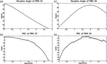
Figure 2 shows the satellite elevation angle and observed PRC from the MARA DGPS reference site for a three-hour period from UTC 00:00 to 03:00 on 4 June 2015. Subplots (a) and (b) correspond to PRN 25, while (c) and (d) correspond to PRN 29. Figures for PRN 25 show that a smaller elevation angle leads to a larger absolute value of PRC. Similarly, strong correlation between the elevation angle and magnitude of PRC can be observed for PRN 29. Thus, we concluded that there exists clear anti-correlation between the magnitude of PRC and the elevation angle. Another thing to note is that PRC changes rapidly when the elevation angle is low, and vice versa.
Observed elevation angles and collected PRC messages from the MARA DGPS station for PRN 25 and PRN 29.

Based on these behaviours, we devised a simple but effective mathematical formula to model the relation between satellite elevation angle and PRC and it is shown in Equation (4). As can be seen from Figures 2(b) and 2(d), the change of PRC over time is similar to a sinusoidal wave. From this observation, we have attempted to develop a new PRC model using sinusoidal functions such as sine and cosine. After trying many different functions, we found that the sine function achieves the best performance because it changes rapidly when the angle is small while it is very slowly changing at larger angles.
 $$PRC_u =\displaystyle{{\sin \theta_r}\over{\sin \theta_u}} PRC_r$$
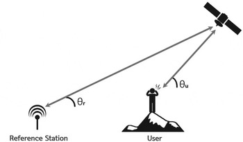
In Equation (4), PRC u is a new PRC value at the user location, while PRC r is that received from a base station. θ u and θ r are the satellite elevation angles at the user and reference site locations, respectively (Figure 3).
Differences in satellite elevation angles at a reference station and the user. The maximum difference was a little less than 5° degrees for the baseline length of 400 km in our case studies.

4. PERFORMANCE ANALYSIS
The National Maritime Position Navigation and Timing (PNT) Office of the Ministry of Oceans and Fisheries in South Korea operates 26 DGPS reference and monitoring stations. Five of them were chosen as base stations for this study: GAGE (Gageo-do), MARA (Mara-do), PALM (Palmi-do), SOCH (Socheong-do), and YNDO (Yeong-do). As shown by red circles in Figure 4, all of them are located in coastal areas or on islands. As the user location, we chose five permanent sites operated by the National Geographic Information Institute (NGII) of the Ministry of Land Infrastructure and Transport, as shown in Figure 4 by blue triangles: SONC (Sunchoen), JIND (Jin-do), SEJN (Sejong), JINJ (Jinju), and CHJU (Jeju-do). All user locations are inside the network of the five DGPS base stations.
Map of DGPS base stations (red circles) and user locations (blue triangles). All locations are permanent GPS sites operated by government agencies in South Korea.

To validate the new DGPS positioning scheme, we used one hour of observation data from UTC 00:20 to 01:20 on 4 June 2015 (DOY 155). Standalone positioning was followed by DGPS positioning, and the two resulting positioning accuracies were compared to compute the amount of improvement achieved with DGPS. For standalone positioning, we used standard data processing steps described in ICD-GPS-200C (2000). However, the ionospheric delay was not corrected through the Klobuchar model, and tropospheric error compensation was not applied. Using our standalone data processing strategy at SEJN, we obtained Root-Mean-Square Errors (RMSE) of 1·4 m and 11·5 m for the horizontal and vertical directions, respectively. At CHJU, these RMSEs were 1·1 m and 11·4 m. The positioning accuracy is poor here because the PRC correction has not been applied yet. In addition, the accuracy of the height is especially low due to the absence of tropospheric correction.
DGPS positioning was achieved next by adding PRC values to the observed pseudorange measurements in the standalone positioning algorithm. PRC messages generated at the five DGPS reference stations were collected for the same time span. To analyse the effectiveness of the new method, the positioning results were compared to those from traditional SR-DGPS and MR-DGPS. RMSE and the ‘improvement percentage’ of the accuracy were considered for comparison. For MR-DGPS, the IDW scheme was adopted to interpolate PRC at the user location, and all five base stations were used.
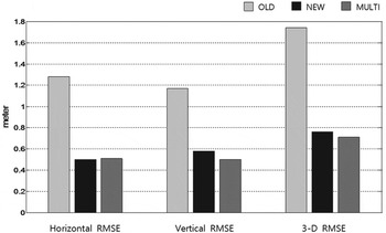
Figure 5 shows the RMSE of positioning results at the user location SEJN. PRC messages from GAGE, which is located 335·7 km away from SEJN, were applied in SR-DGPS processing. The horizontal, vertical and 3-D RMSE values were 1·28, 1·17 and 1·74 m, respectively. Compared to those from standalone positioning, the improvements are quite significant, especially in the height component. This is because PRC messages are very effective in reducing the tropospheric delay, which mostly affects the vertical coordinate. The horizontal, vertical and 3-D RMSE values from the new model were 0·50, 0·58, and 0·76 m, respectively. Thus, the improvement percentage is larger than 50% in all three directions. This level of accuracy is comparable to that of MR-DGPS, for which RMSE values were 0·51, 0·50, and 0·71 m, respectively.
RMSE of the traditional method (OLD), new method (NEW), and multi-reference (MULTI) DGPS at the user location SEJN.

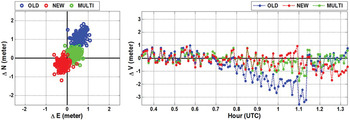
DGPS coordinate estimates are shown in Figure 6, where horizontal deviations are depicted in the north-south and east-west directions with respect to the true position and heights as a time series. In the left plot, traditional DGPS positioning produces biases of 1·1 m and 0·6 m in the north and east directions, respectively. However, the corresponding bias decreases to
 $-0\!\cdot\!3$
m and
 $-0\!\cdot\!2$
m, which are similar to those of MR-DGPS. For the vertical direction, the new DGPS positioning results are free of large deviations, which are as high as
 $-3\!\cdot\!4$
m with the traditional DGPS. The height bias was reduced from
 $-0\!\cdot\!6$
m to less than
 $-0\!\cdot\!2$
m. It is notable that the positioning error magnitudes are similar to those of MR-DGPS, even though the correction messages are from a base station more than 300 km away from the user location.
Position estimates in the horizontal and height directions obtained from the traditional method (OLD), new method (NEW), and multi-reference (MULTI) DGPS at the user location SEJN.

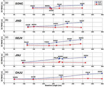
For thorough validation of the new DGPS model, 25 different baseline combinations were tested using the five reference stations and five user locations. The resulting RMSE values are shown in Figure 7, where each subplot corresponds to the user location, and the horizontal axis represents the baseline distance between the user site and base stations in km. The shortest baseline is ~50 km between CHJU and MARA, while the longest is ~500 km between CHJU and SOCH. The positioning error increases proportionally to the distance for the traditional DGPS with correlations ranging from 0·82 to 0·98. The correlation coefficient r was computed by Equation (5), where n is the number of data points and
 $\bar {X}$
and
 $\bar {Y}$
are the mean of X
i
and Y
i
, respectively. In this case, X
i
is the baseline length between the reference and rover sites, and Y
i
is the three-dimensional RMSE. The correlation of the new method is 0·38 on average, which means that it can effectively reduce the spatial correlation of distance-dependent errors. For the improvement percentage, the overall correlation coefficient with respect to baseline length was quite high at 0·80.
RMSE at five user locations and their variations according to baseline length to the base station: OLD and NEW mean traditional DGPS and the new DGPS scheme.

 $$r=\displaystyle{{\sum_{i=1}^n {(X_i -\bar {X})(Y_i -\bar {Y})} }\over{\sqrt {\sum_{i=1}^n {(X_i -\bar {X})^2} } \sqrt {\sum_{i=1}^n {(Y_i -\bar {Y})^2}}}}$$
Importantly, the improvement in Figure 7 is not as noticeable when the baseline length is less than 200 km. The average improvement is about 14% for the seven cases with distances less than 200 km. For distances greater than 250 km, the improvement ranges from 29% to 66%. The lowest improvement of 29% was observed for SONC-PALM, for which the baseline length is 280·5 km, while the greatest improvement occurred for JINJ-SOCH, where the inter-site distance is 413·4 km. The reason why no significant improvement was observed for short baselines is that the elevation angle does not differ much for nearby locations.
5. CONCLUSIONS
We devised a new model to use satellite elevation angles in SR-DGPS to improve positioning accuracy and validated its performance. Five user locations were chosen from a subset of the South Korean DGPS network, and 25 different combinations of baselines were tested. The positioning results did not improve much when the distance was less than 200 km, but the improvement percentage was significant for baselines greater than 250 km and ranged from 29% to 66%. We also found that the improvement is proportional to the distance, and the correlation coefficient was 0·8. Thus, the new model should be very effective in reducing distance-related DGPS positioning errors.
ACKNOWLEDGMENTS
This research was supported by a grant (17NSIP-B082188-04) from National Land Space Information Research Program funded by Ministry of Land, Infrastructure and Transport of the Korean government and Korea Agency for Infrastructure Technology Advancement.