Cumbria
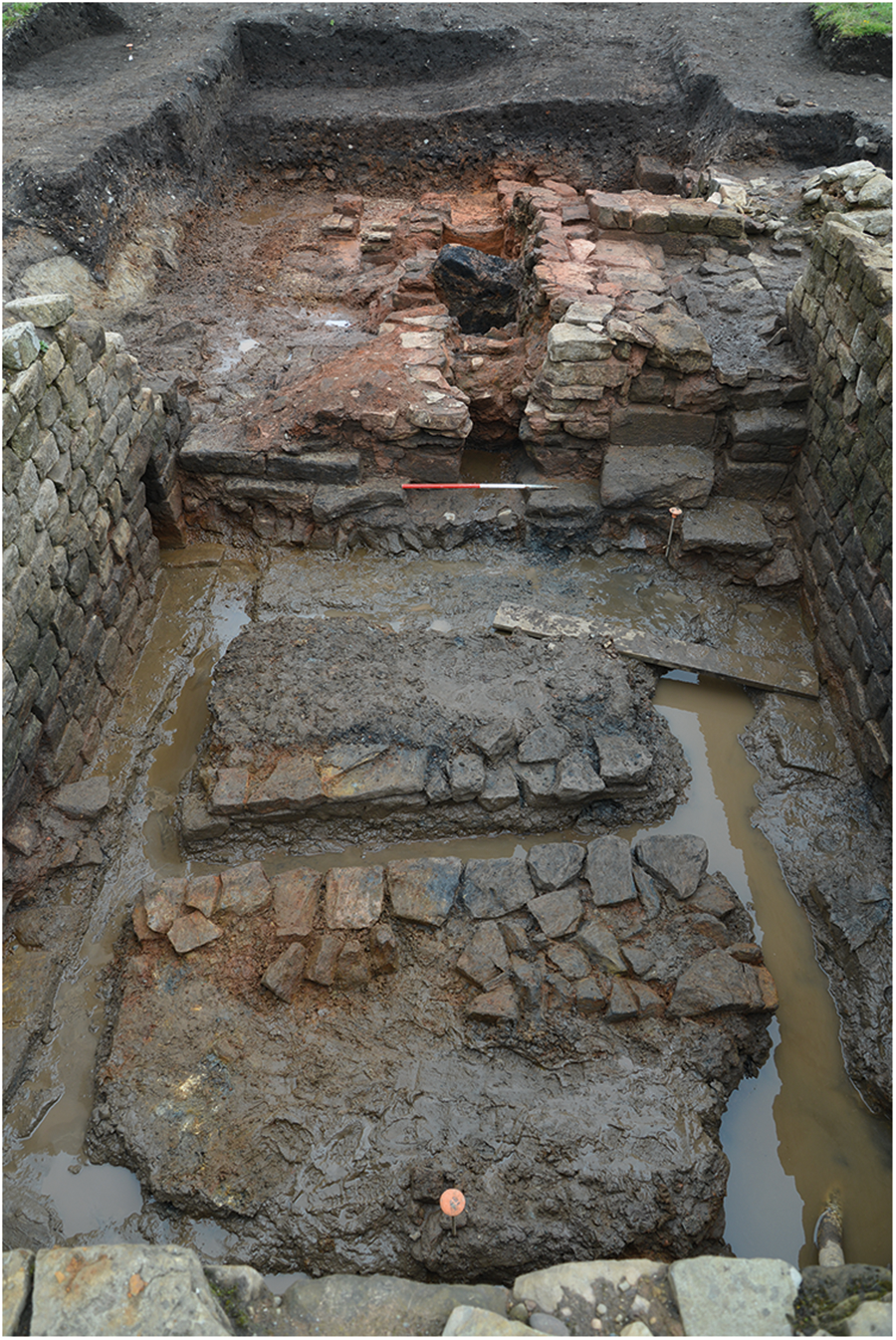
(1) Birdoswald (Banna) (NY 615 633): work continued in two of the areas opened up in the extramural area beginning in 2021 and continuing annually to the final season in 2024.Footnote 18 In Area A, the building first examined by Richmond in 1930 was further confirmed to have been the praefurnium of the fort bathhouse. Details of both firing and water supply were examined. A maximum of 14 courses of masonry (2.15 m) survived. Seven of these courses were beneath primary Roman ground surface. The stoking chamber was thus semi-subterranean, built into a large rectangular pit. Prior to the construction of the building a deep drain was built, running from the north and designed to carry ground water beneath the floors of the subterranean structure (Fig. 8). This formed a contemporary offshoot from the rectangular construction cut for the construction of the building. The drain was capped by massive sandstone slabs. Outside the north wall of the building a stone-lined vertical shaft led through the wall emerging at the base of the wall through an aperture built into the wall and capped with a lintel incorporated in the ninth course from the base. This shaft lay at the end of a run of timber water pipes evidenced by in situ iron connection rings. There can be little doubt that this was how the water supply entered the building.
Birdoswald bathhouse praefurnium; the flue viewed from the stoking chamber with its underfloor drain (© HE Archaeological Projects Team).

The western end of the excavated structure was the stoking chamber from which the fire was fed, and into which waste products were raked back. At the eastern end of the stoking area was the furnace. This comprised a flue-channel built of clay-bonded and sealed stone, all of which had been fired and shattered by fire. Across the flue were three iron bars measuring 1.2 m long and 150 mm square in section. These would have supported a metal half-cylindrical testudo over the fire. To one side of the flue was a stone platform accessed by stone steps from the stoking chamber. This platform would have supported a metal boiler. A variety of large stone objects pierced with circular holes of a common diameter were probably supports for metal pipework.
The east end of the flue opened into a hypocaust. The proximity of this to the fire bars and therefore the testudo suggests that the hypocaust supported the hot water bath. Twenty-nine pilae were excavated comprising a variety of stone and ceramic tiles. A complete displaced box-flue tile was found in the hypocaust fill. The semi-subterranean level of the base of the hypocaust meant that the floors of the heated rooms would have been level with the exterior gravel surfacing. The stratigraphic position of the construction pit for the bath building confirms that it is a primary structure. A long-known but anomalous culvert in Hadrian’s stone Wall may now convincingly be interpreted as the point at which an aqueduct entered the area of the fort, running in a straight line via wooden pipes to the bath building. This culvert is of one build with the Hadrianic stone Wall. It seems therefore that the bathhouse and the water supply were integral to the construction of the stone Wall, which at Birdoswald replaces the turf Wall as the linear barrier.
To the east of the fort, it was clear that the road out of the fort’s principal west gate expanded into a broad oval open area. On the south side of this area primary timber structures cut into the surviving fabric of the turf Wall were succeeded by several industrial heaths or kilns. To the south of the area were several long narrow strip buildings with their short end walls opening onto the open area.Footnote 19
Northumberland
(1) Halton Red House, B6318 Halton Shields to A68 Route Action Scheme, Military Road, Northumberland (NZ 00241 68513): the probable remains of Hadrian’s Wall were identified within the post-holes for replacement road signs 315A and 315B along the northern verge of the B6318 Military Road at Halton Red House in Northumberland.Footnote 20 Two 0.35 m diameter post-holes were excavated for each sign with sandstone masonry uncovered within all four post-holes between 0.24 m to 0.42 m below ground level.Footnote 21
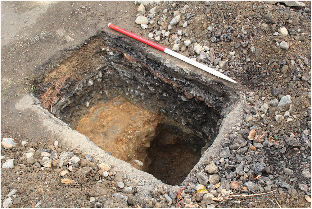
(2) Heddon-on-the-Wall, Street Light Replacement Scheme (NZ 13351 67010): an evaluation in December 2017 ahead of the replacement of street-light columns along Hexham Road, Heddon-on-the-Wall, uncovered the truncated remains of Hadrian’s Wall in Trench 14HK that comprised sandstone rubble bonded with clay, approximately 0.50 m below present ground level (Fig. 9).Footnote 22 These remains are thought to represent the rubble core of Hadrian’s Wall with the outer facing stones robbed out at a later date.Footnote 23
Hadrian’s Wall (wall core) in Trench 14HK, view north-east, 1 m scale (© Pre-Construct Archaeology Ltd).

(3) Magna, Milecastle 46 and the field to the north of the fort (NY 66467 66015): in 2024 the excavations at the fort and milecastle of Magna completed the second year of a five-year project in the field to the north of the fort. The remains of a military ditch of Roman date were explored below the cobbled surfaces to the immediate east of the milecastle. The ditch measured 2.2 m in width at the top and continued east beyond the limit of the excavation. The cut had a steep profile, and an additional V-shaped slot cut into its base, with a total depth of 0.48 m. This feature could have been associated with a hitherto unknown marching or temporary encampment that pre-dated the construction of Hadrian’s Wall. The feature contained datable Roman material which included sherds of amphora and Samian.
In the 48 m from the position of the milecastle’s south wall to the cut for the north side of the vallum ditch A pre-Roman ditch and pre-Hadrianic Roman pits were encountered. The ditch produced a single sherd of pre-Roman Iron Age pottery and formed a rough D-shaped boundary. The Iron Age ditch and pre-Hadrianic features had been filled with debris to make a large Roman yard area to the south of the milecastle and to allow the military way to pass smoothly through the landscape. At the junction between the road from Magna and the military way a Roman stone-lined well had been cut into the natural boulder clay. This feature was well constructed, filled with silt, and produced a single Roman glass bead. The northern line of the military way was marked by a boundary ditch which was full of grey silt and several pottery sherds, suggesting a long use. The southern edge of the military way had been placed against the northern edge of the north turf and clay mound of the vallum.
Although only preserved down to its foundations, the north mound of the vallum retained evidence for the individual spades of clay and turf used to make its foundation. The north berm was intersected by several pits and ditches in the space between the mound and the vallum cut. The ditch cuts marked the edge of a cemetery, and the largest of the pits contained funerary waste from several different cremations. Surrounding this pit were a further cluster of smaller cremation deposits.
Excavations within vallum were hampered by the wet summer of 2024 with daily flooding for several months. The vallum cut had a width of 8.9 m at its top, and a 3 m wide section was dug down to the base which sat at around 1.9 m in depth. The fill of the vallum included a large amount of turf and clay from the adjacent north and south mounds which had been redeposited to fill the ditch. The ditch fill included several artefacts, such as pottery, CBM, roof tiles and animal bones. A large Roman leather shoe was found near the base of the ditch. Work continued to explore the remains of the pre-Hadrianic landscape below the southern mounds of the vallum, with the partial remains of further linear ditches encountered that may have been associated with the Iron Age features further to the north. This area produced no Iron Age ceramics or other datable material.
Sixteen metres to the south of the vallum were the remains of a much larger pre-Hadrianic ditch with a width of 7.19 m and a depth of over 2 m. The ditch ran in an east–west direction and an 8 m wide section was cut through the feature to reveal its contents. The fill below the topsoil cover was anaerobic and filled with organic matter deposited from the run-off from the surrounding peat bog. The ditch showed evidence of at least one substantial re-cut and the remains of a silver birch grove taking root on its northern side. Several instances of slumping from its northern side had taken place while the feature was open, partially filling the base with a mixture of heavy boulder clay and stones. The organic fill included seven Roman shoes, three large oak timber planks and large amount of pottery. The remains of an antler dice tumbler and copper-alloy lorica squamata were also recovered. This ditch is substantial enough to have been associated with an early pre-Hadrianic fort or perhaps a military annexe.
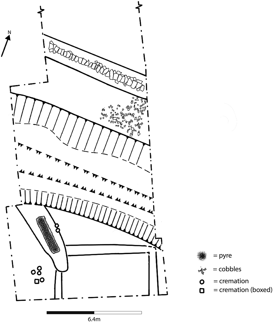
Cut into the natural clay on the southern side of the ditch were the remains of a series of angular trenches for timber beams, forming a building foundation associated with the ditch’s use, and a slightly later rectilinear pit that had been used as a funeral pyre site once the ditch and associated buildings were no longer required. The area surrounding the pyre site produced several cremation burials, the earliest of which had been placed into a wooden box. The charcoal from within this cremation has been radiocarbon dated to between 110 and 236 cal. a.d. (90.3 per cent probability). This is the earliest radiocarbon date for all the cremation burials from this area of the site, although it appears that the site of the pyre remained in use until the mid-fourth century (Fig. 10).
Plan of the pre-Hadrianic ditch with timber building foundation and cremation cemetery to the south and a modern drain to the north (© The Vindolanda Trust).

A final trench in the field to the north of the fort investigated a post-Roman well. This feature had been cut through the Roman-period peat that underlay its foundations, and this Roman layer of peat produced some unusual features which may have been associated with the tanning industry. A series of horse manure deposits, some rounded, others rectilinear, were dumped into the peat. Bark was stripped from silver birch trees and laid out in rafts surrounding the manure and the remains of two wooden posts were the possible location of a frame used to clean and hang hides. In 2025 the excavation will move to explore the northern ditches of the last stone fort at Magna before entering the fort to start work on the site of the praetorium.Footnote 24
(4) Vindolanda, the northeastern quadrant of the last stone fort (NY 769 663): on 8 April 2024, the Vindolanda Trust started the excavations as part of a new five-year plan entitled ‘the Castrum Project’. The project is designed to complete the excavations of the third- and fourth-century fort at Vindolanda. The archaeological examination, and in some areas re-examination, of the northeastern quadrant of the last stone fort and its associated eastern defensive ditch are key objectives. At the project’s conclusion, in 2028, all quadrants of the third- and fourth-century fort at Vindolanda will have been comprehensively explored and recorded.
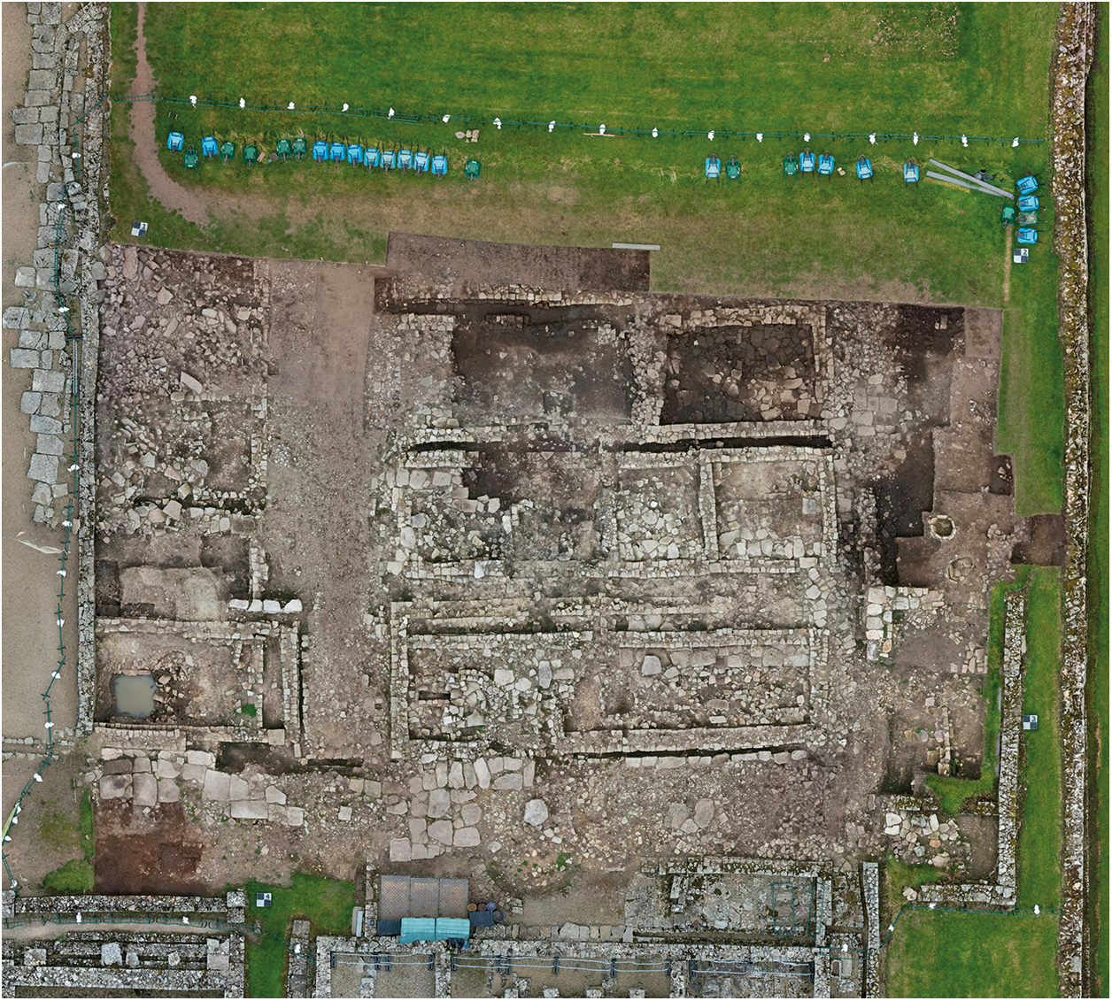
Castrum will provide the most complete dataset of third- and fourth-century material culture yet to come from a fort in the Roman Empire. The excavations will encounter and contextualise previous smaller-scale archaeological exploration in this area, including but not limited to the work of Rev. Anthony Hedley between 1829 and 1835,Footnote 25 Eric Birley in 1929–35,Footnote 26 Robin Birley in 1979, Patricia Birley and Paul BidwellFootnote 27 in 1980. Excavations started to the immediate north of the remains of the principia and praetorium and uncovered the final phasing of the via principalis roadway. The road was partially paved with large, 1 m long by 1 m wide flagstones, comparable in size to the ones used in other surviving flagged roads inside the fort (Fig. 11). The newly discovered stretch of the via principalis was between 6 m and 4.5 m wide and 33.4 m long, crossing the length of the excavation area and reaching the fort’s rampart. In the western portion of the quadrant were a series of poorly preserved late-fourth-century stone-built structures, opening onto a north–south-oriented metalled surfaced barrack road. The building stones were marked by ploughing, as were several of the larger stone elements in the metalled street to the east of the structures. The buildings were similar in design to the ‘chalet type’ structures explored in the north-western quadrant of the fort, excavated between 2008 and 2012.Footnote 28 The buildings excavated here formed a single street of north–south-oriented detached houses based on the foundations of an earlier third-century barrack, set between the via praetoria and a metalled barrack road.
An aerial photograph of the excavated area taken in September 2024 (© The Vindolanda Trust).

To the east of the metalled road were four east–west-oriented rectangular buildings, on average 18.5 m long (including the thickness of the walls) and 5.2 m wide. These were different in character to the detached structures to the west. As well as being larger and better preserved, the eastern buildings were multi-roomed and semi-detached, with narrow corridors (60 cm wide) separating them one from another. The most southerly of these rectangular building showed evidence of multiple phases of use, standing originally at 6 m wide and having been reduced in size to 5.2 m wide, to match the other three. This building featured a large oven situated within its western perimeter. The oven had a well-preserved flagged chamber c. 3 m in diameter, that might have served a commercial enterprise rather than domestic purposes, perhaps a bakery at the busy junction between the via principalis and the barrack road. Aside from the oven, the other notable feature within this space was a well-defined phallic symbol that had been picked into one of the flagstones on the floor. Features like this have been found to have been associated with designated cooking and eating spaces at Vindolanda, such as the statue of Priapus that was excavated next to a rampart oven in 2005 (SF10497).Footnote 29
The excavations in this area explored two previously unknown trenches from Eric Birley’s 1930s campaigns. One had been placed into the floor of the first fourth-century detached building adjacent to the principia and had been backfilled with loose rubble to a depth of 1.7 m. Another trench had also been placed into the next barrack room to the north. Birley was working on the assumption that the principia had been built on the northern side of the central range of the fort, and his exploratory trenches proved that this was not the case. The hitherto hidden location of Birley’s spoil heaps from his exploration work were uncovered and recorded within the 2024 excavation area. Finds from the historic archaeological spoil heaps included glass vessels, two leather shoes and an assortment of twentieth-century cups and plates.
The excavations discovered that Birley was not the first person to explore this area: the remains of several stone-robbing trenches were uncovered during the work. One of these, an elongated trench that snaked along the line of two walls, produced a worn early brass coin of Mary Queen of Scots (C3492) with the unusual feature that the reverse of the coin had been purposely defaced to make it unusable as currency. Although very worn, this coin likely dates some of the stone-robbing activities to the later seventeenth or early eighteenth century.
To the north of the potential bakery a series of fourth-century barrack buildings were discovered. While not precisely matching the structures recorded by Bidwell,Footnote 30 they were different from the later fourth-century detached building encountered elsewhere. These structures were preserved to a height of 80–95 cm or four courses of masonry and, barring damage from stone robbing, most had intact flagstone and earthen floors, many of which were covered by very late Roman or perhaps sub-Roman rubble surfaces made from re-using facing stones as rough cobbles. The excavations recovered 134 coins in 2024, most of which are dated to the fourth century. The late Roman dating of the phasing was supported by a large quantity of calcite gritted wares.
Finds of note included: a copper-alloy figurine of Mars on its stand (SF24514), similar to the Cullompton Mars figurine;Footnote 31 a lead-filled copper-alloy head a of a bull deity, and the stone head of an unknown goddess wearing a mural crown (Fig. 12). The Bull deity is the second representation of a copper-alloy bull to come from the site. The other (SF24500) was found in a context from below the third-century praetorium in 1998, a bull-headed lamp on its stand. The goddess with mural crown is similar, although not identical to an example recovered during the WallCap project in 2014 at South Shields. It may be that this is another depiction of the goddess Brigantia, which is also shown on a statue at Birrens, recovered in 1731.Footnote 32 However, it may also have represented a very different figure or deity. The excavations of 2024 explored around 40 per cent of the northeastern quadrant’s surface area. The archaeological work will re-recommence in April 2025.Footnote 33
Tyne and Wear
(1) Newcastle-upon-Tyne, Castle Garth/St Nicholas Street (NZ 25024 63858): Pre-Construct Archaeology’s Durham office undertook an archaeological evaluation and watching brief prior to and during a scheme of highway works located around the junction of St Nicholas Street and Westgate Road and St Nicholas Street, Queens Lane and Castle Garth between July and November 2018. Significant archaeological remains were encountered within Trench 5 that exposed a 1.07 m long east–west sandstone wall of probable Roman date,Footnote 34 which is thought to be either the northern external wall or an internal division within the western barrack block of Pons Aelius Roman fort due to its location to the south of the Principia based off the hypothetical reconstruction of the fort.Footnote 35 Although no datable material was recovered from the wall it is almost certainly Roman in origin, as it was sealed by post-Roman demolition/dump material and truncated by early medieval burials (Fig. 13).Footnote 36