Introduction
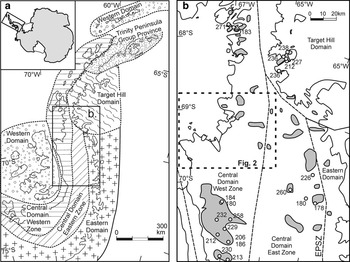
Geochronological relationships at the junction of north-west Palmer Land and south-west Graham Land, a zone of distinct physiographic change in the Antarctic Peninsula, are relatively poorly known compared to some other parts of the Antarctic Peninsula. The area is a classic magmatic arc terrane, dominated by plutonic, hypabyssal and subaerial volcanic rocks with no significant sedimentary formations. It forms part of the aerogeophysically and geologically defined Western Zone of the Central Domain of the Antarctic Peninsula (Fig. 1), a Mesozoic magmatic arc terrane that formed in response to subduction along the Pacific margin of Gondwana (Vaughan & Storey Reference Vaughan and Storey2000, Ferraccioli et al. Reference Ferraccioli, Jones, Vaughan and Leat2006). Most of the area shown in Fig. 2 is poorly described in the literature. The area dominated by volcanic rocks south-west of the Fleming Glacier has been described by Davies (Reference Davies1984) and Leat & Scarrow (Reference Leat and Scarrow1994), and the volcanic rocks were Rb-Sr dated by Thomson & Pankhurst (Reference Thomson and Pankhurst1983). Most of the area north of the Fleming Glacier is dominated by plutons and orthogneisses, with minor volcanic sequences. Although uncomformable and intrusive relationships have been observed locally, age relationships are inevitably heavily dependant on geochonological data.
a. Terrane map for the Antarctic Peninsula after Vaughan & Storey (Reference Vaughan and Storey2000) and Ferraccioli et al. (Reference Ferraccioli, Jones, Vaughan and Leat2006). The area shown in panel b is indicated. b. Areas with significant ‘basement’ outcrops. Spots indicate U-Pb zircon ages for the protoliths and metamorphism affecting them. Age information from Vaughan et al. (Reference Vaughan, Millar and Thistlewood1999), Millar et al. (Reference Millar, Pankhurst and Fanning2002), Flowerdew et al. (Reference Flowerdew, Millar, Vaughan, Horstwood and Fanning2006) and BAS unpublished data.

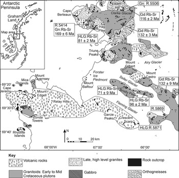
Geological sketch map of north-west Palmer land and south-west Graham Land showing the location of the dated samples. The map is compiled from Davies (Reference Davies1984), unpublished reports by Wyeth (Reference Wyeth1972, Reference Wyeth1973), and fieldwork by PTL, JHS and ILM in the seasons 1991–92 and 1992–93. The Rb-Sr ages are from the authors’ unpublished data: Gn = gneiss, Gd = granodiorite, HLG = high-level granite. Inset shows the location within the Antarctic Peninsula; AI = Alexander Island.

We report whole rock and zircon U-Pb geochonological data in this paper. Multiple samples of plutons or orthogneiss sequences we mapped in the field were chosen for Rb-Sr geochronology. A subset of samples was analysed for Sm-Nd isotopes. One sample of orthogneiss and one volcanic sample were chosen for U-Pb dating of zircon crystals.
Regional field relationships and Rb-Sr and Sm-Nd results
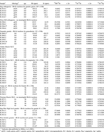
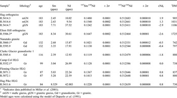
The Rb-Sr whole rock geochronology forms a basis for understanding age relationships in the area, so is discussed with the field information and Nd isotope data. Rb-Sr and Sm-Nd analytical methods used for data in this paper are those of Royse et al. (Reference Royse, Kempton and Darbyshire1998). Whole-rock Rb-Sr geochronological data are shown in Fig. 2 and Table I, and Nd isotopic data are shown in Table II. Apart from four Rb-Sr and three Sm-Nd analyses (including three pairs) reported in supplementary data tables by Millar et al. (Reference Millar, Willan, Wareham and Boyce2001), all the data in Tables I & II are previously unreported.
Whole rock Rb-Sr data.

1 *indicates data published in Millar et al. (Reference Millar, Willan, Wareham and Boyce2001).
2 mGN = mafic gneiss, gGN = granitic gneiss, Gd = granodiorite, mGd = microgranodiorite, Di = diorite, Gr = granite, Peg = pegmatite, Ap = aplite.
Whole rock Sm-Nd data.

1 *Indicates data published in Millar et al. (Reference Millar, Willan, Wareham and Boyce2001).
2 mGN = mafic gneiss, gGN = granitic gneiss, Gd = granodiorite, Gr = granite.
Model ages were calculated using the model of Depaolo et al. (Reference Depaolo, Linn and Schubert1991).
Basement rocks (i.e. crystalline, metamorphic rocks) in the area of Fig. 2 are represented by scattered exposures of orthogneisses that outcrop from the Elton Hill area in the north to the head of the Seller Glacier in the south. These orthogneisses are poorly known in the area, but are thought to represent deformed and metamorphosed volcanic and plutonic rocks of dominantly intermediate to silicic composition (e.g. Davies Reference Davies1984). Whole rock Rb-Sr dating of an outcrop west of Hag Pike indicates a 169 ± 6 Ma, mid-Jurassic protolith age for the orthogneiss (Table I), and a suite of orthogneisses from around Elton Hill yielded no meaningful isochron. Evolved Nd signatures for silicic gneisses (εNd183 = -2.9 and -2.6; Table II) shows that an older crustal component was sourced during petrogenesis. A gabbro-granodiorite plutonic suite that intruded the orthogneisses dominates outcrop in the area north of the Fleming Glacier (Fig. 2). This suite is apparently undeformed, apart from magmatic foliations clearly associated with intrusive contacts with other plutons or the orthogneisses. Rb-Sr whole-rock isochrons for two granodiorite plutons of this suite, exposed around Clarke Glacier and in a group of unnamed nunataks at the head of the Seller Glacier yield ages of 116 ± 2 and 132 ± 9 Ma, although the accuracy of these ages is uncertain, because the long magmatic history of the area suggests the potential for resetting the Rb-Sr system. Nd isotopes for these granodiorites are less negative than the gneisses (εNdt = -1.8 to -0.4; Table II). A distinctive group of later, vuggy, red-weathering high-level granites represents the last observed plutonic episode, outcropping in a zone from Cape Berteaux to the head of Fleming Glacier (Fig. 2), and showing clear intrusive relationships with older units. These granites range from subalkaline to peralkaline (comenditic: Davies Reference Davies1984, authors’ unpublished data), have yielded Rb-Sr isochrons in the range 71 ± 9 to 96 ± 2 Ma (Table I). They correspond to the alkali microgranites described from Mount Lepus and other parts of north-west Palmer Land by Scarrow et al. (Reference Scarrow, Vaughan and Leat1997) and Vaughan et al. (Reference Vaughan, Millar and Thistlewood1999). The Nd isotopic signature of the later plutonic rocks (εNdt = 0.0 to +0.8; Table II) is more juvenile than the basement (εNd87 = -3.6 to -3.0 for silicic orthogneisses and -0.9 to -2.3 for older Cretaceous plutonic suite; Table II), indicating an increased contribution from a mantle-derived component during petrogenesis.
The volcanic rocks that dominate south and west of Fleming Glacier belong to a basalt to rhyolitic sequence that is weakly deformed by long-wavelength folding. The sequences are interpreted as eroded remnants of large, central volcanoes, including a caldera structure at Zonda Towers (Leat & Scarrow Reference Leat and Scarrow1994). Davies (Reference Davies1984) interpreted the volcanic rocks as Upper Jurassic in age by comparison to dated volcanic sequences elsewhere in the Antarctic Peninsula. A Jurassic age was apparently confirmed by Thomson & Pankhurst (Reference Thomson and Pankhurst1983), who found that the northern Palmer Land volcanic rocks trended along a Rb-Sr reference line of approximately 180 Ma, and R.J. Pankhurst (personal communication, 1993), who suggested a Rb-Sr age of 153 ± 2 for volcanic rocks from a single location near Mount Edgell. The generally higher crustal level (mostly volcanic rocks) exposed south of the Fleming Glacier compared to the north (mostly plutonic and metamorphic rocks) suggests that the Fleming Glacier may overlie a significant fault that downthrows to the north. This coincides with a lineament along which sinistral strike-slip movement is inferred from displacement of aeromagnetic anomalies associated with the underlying batholith (Garrett Reference Garrett1990, Johnson Reference Johnson1997). There are large numbers of hypabyssal intrusions, mostly mafic dykes dated by K-Ar methods as Cretaceous to Early Tertiary in the area which intrude all other rock types (Scarrow et al. Reference Scarrow, Leat, Wareham and Millar1998).
Zircon U-Pb geochronological results
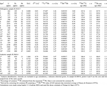
We present new U-Pb geochronological data on zircons from an orthogneiss and a volcano-sedimentary sequence that uncomformably overlies a granodiorite. These provide better constraints on volcanic and tectonic events in the arc terrane, and we relate these to regional events. U-Pb zircon analyses were carried out using a Cameca 1270 ion-microprobe housed at the NORDSIM facility, Swedish Museum of Natural History, following the method of Whitehouse & Kamber (Reference Whitehouse and Kamber2005). Results are presented in Table III.
U-Pb ion-microprobe zircon data.

1Analysis identification. Asterisks are included in age calculations, i indicates inherited grains. In sample R.5869.4, points 8 and 9 are the core and rim respectively of the same crystal.
2Percentage of common 206Pb estimated from the measured 204Pb. Data is not corrected for common Pb.
3Derived by correcting for common Pb assuming a 207Pb/206Pb value of 0.83 (present day terrestrial average of Stacey & Kramers (Reference Stacey and Kramers1975)).
Calculations were made using Isoplot 3.1 (Ludwig Reference Ludwig2003) and used the decay constants of Steiger & Jäger (Reference Steiger and Jäger1977).
Orthogneiss sample R.5414.7
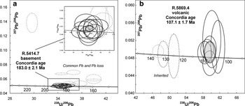
The orthogneiss comes from a 2.5 km-long outcrop on a north–south trending ridge which is situated on the south coast of Cape Berteaux, 6 km north-west of Hag Pike, south-west Graham Land (Fig. 2). The sample was collected from the west-facing slopes of the ridge, which exposes silicic-intermediate medium-grained orthogneiesses which are foliated and highly folded with sparsely developed crenulation cleavage. The gneisses are cut by folded amphibolite sheets, and they are interpreted as an igneous succession cut by mafic dykes, the whole sequence having been deformed and metamorphosed at about ambibolite grade. Sample R.5414.7 is a medium-grained, moderately foliated quartz-feldspar dominated metamorphic rock. The medium grain size and an interpreted relict phenocrystic texture indicate volcanic rather than plutonic protoliths. Zircons are prismatic and, although generally non-luminescent under CL, faint growth zoning is evident and no inherited component was detected in the images. Zircons yielded a well-defined U-Pb zircon concordia age of 183 ± 2.1 Ma. Discordant analyses contain common Pb or are interpreted to have suffered Pb loss (Table III; Fig. 3). This new radiometric age is interpreted to date emplacement of the igneous protolith comprising the local basement and demonstrates that our whole-rock Rb-Sr isochron age of 169 ± 6 Ma is erroneous (Fig. 2). The Rb-Sr age probably reflects resetting or original emplacement of magmas with variable 87Sr/86Sr ratios, consistent with multiple crust and mantle magma sources in a magmatic arc, or continental margin environment.
U-Pb Concordia diagrams for a. orthogneiss sample R.5414.7, and b. Silicic lava sample R.5869.4. Dashed ellipses are not included in age calculations and are interpreted as either inherited, containing common Pb or having suffered Pb loss.

Volcanic sample R.5869.4
The volcanic sample R.5869.4 is from a volcanic and sedimentary succession that uncomformably overlies a granodiorite at the head of the Fleming Glacier, northern Palmer Land (Fig. 1). The location was described by Davies (Reference Davies1984) and re-examined in season 1992/93 (Scarrow & Leat Reference Scarrow and Leat1993). The granodiorite has a weak magmatic foliation, and has experienced alteration of feldspars and epidote veining (Davies Reference Davies1984). The basal beds overlying the uncomformity consist of poorly sorted, graded sandstones and siltstones, which dip 28° to the north-west and contain plutonic clasts up to 1 m across. These are overlain by a 10 m thick, silicic, massive, lava-like unit, from which sample R.5869.4 was taken. This is in turn overlain by a 4 m thick unit of fine-grained, planar bedded, silicic tuffs. The beds are c. 1 cm thick, graded or reverse graded and some contain accretionary lapilli. The sequence is interpreted as terrestrial. Sample R.5869.4 is homogeneous, plagioclase-phyric and fine-grained with no obvious pyroclastic features. It contains abundant minor fractures associated with epidote crystallization and has clearly suffered minor deformation. Zircons are prismatic, bright, have well-developed crystal facets and are luminescent under CL with growth and sector zoning, features typical for volcanic zircon. Under CL, core-rim structures are obvious with rims being more luminescent with internally simple structure compared with less luminescent cores and xenocrysts. Volcanic grains without inherited cores have the same CL character as the rims. The sample yielded a U-Pb zircon age of 107 ± 1.7 Ma (Table III; Fig. 3) that is interpreted as the eruption age. Cores and xenocrysts yield older ages of around 130 Ma confirm the inheritance suggested by the CL images.
Discussion
Basement
The Early Jurassic age of 183 ± 2.1 Ma for orthogneiss sample R.5414.7 is interpreted as the age of eruption/emplacement of its igneous protolith. The Early Jurassic age indicates that Palaeozoic to Triassic basement protoliths, that have been identified elsewhere in the Antarctic Peninsula by U-Pb zircon geochronology (Millar et al. Reference Millar, Pankhurst and Fanning2002; Fig. 1), may be absent from this area. At the very least, such Palaeozoic to Triassic basement is absent from this locality. However, εNd at 183 Ma of -2.9 (Table II) indicates that these rocks are not juvenile crustal additions, suggesting that an older crustal basement is unexposed or unsampled in the area. This is consistent with the study of Millar et al. (Reference Millar, Willan, Wareham and Boyce2001), who found a widespread Proterozoic lower crustal component in granitoids of Palmer Land. It is intriguing that the age of 183 Ma corresponds with the first of the three episodes of widespread voluminous Chon Aike silicic volcanism identified along what is interpreted as the Jurassic margin of Gondwana, in the Antarctic Peninsula and in Patagonia (Pankhurst et al. Reference Pankhurst, Leat, Sruoga, Rapela, Márquez, Storey and Riley1998, Riley & Leat Reference Riley and Leat1999). The protoliths of the south-west Graham Land orthogneisses may have been outliers of this episode, or alternatively may have been magmatic arc rocks related directly to subduction processes occurring at the same time. The first (V1) episode of Chon Aike magmatism (188–178 Ma) is interpreted to have been linked to the Karro-Ferrar mantle plume-related volcanism and is represented in Patagonia by the voluminous Marifil Formation, and in the southern Antarctic Peninsula by the Mount Poster and Brennecke formations (Pankhurst et al. Reference Pankhurst, Riley, Fanning and Kelley2000). Cape Berteaux lies between these occurrences, indicating that V1 may have been originally more continuous, but perhaps obscured by later deformation along the continental margin. Moreover, the εNdt of -2.9 and the initial 87Sr/86Sr ratios of 0.7051 to 0.7078 (Tables I & II) of the Cape Berteaux orthogneiss at 183 Ma is very similar to most Antarctic Peninsula and Patagonian Chon Aike representatives (-2 to -3 and 0.706 to 0.707 respectively), consistent with melting of a similar Proterozoic lower crustal source (Riley et al. Reference Riley, Leat, Pankhurst and Harris2001) for all these Jurassic silicic magmas.
Age of the volcanic cover
The 107 ± 1.7 Ma U-Pb age for silicic lava R.5869.4 clearly demonstrates a mid-Cretaceous age for the volcanic and sedimentary sequence overlying the uncomformity. Davies (Reference Davies1984) assumed, by analogy with wider stratigraphical relationships in the Antarctic Peninsula, that all the volcanic rocks in the area, including those above the unconformity, were Jurassic, and older than the plutonic rocks of the ‘Andean Intrusive Suite’. This assumption led to problems in stratigraphical correlation, as Davis was forced to invent a separate lithostratigraphic category ‘Pre-Volcanic Plutonic Rocks’ in which to place (along with plutonic rocks from Mount Charity, Palmer Land) the granodiorites that are below the uncomformity. This term is now redundant, as there is no requirement for the granodiorites below the uncomformity to be older than most other (Cretaceous) plutonic rocks in the area.
We interpret the new U-Pb data to further indicate that the large outcrop of volcanic rocks between Cape Jeremy and Crescent Scarp (Fig. 2) is more likely to be Cretaceous than Jurassic, as previously supposed (Thomson & Pankhurst Reference Thomson and Pankhurst1983, Davies Reference Davies1984, Leat & Scarrow Reference Leat and Scarrow1994). Although the volcanic succession above the uncomformity is not continuous with the larger outcrop, the Cretaceous U-Pb age is the only unequivocal age for volcanic rocks from this area. All these sequences have similar degrees of deformation and metamorphic grade, up to prehnite-pumpellyite facies (Davies Reference Davies1984), quite different from the higher grade orthogneisses for which we have established a Jurassic or older protolith age in southern-most Graham Land. A Jurassic age for the volcanic cover of north-west Palmer Land would require large variations in metamorphic grade of Jurassic volcanic rocks within the same terrane and over a geographically restricted area, for which there is no evidence.
Given that the dated volcanic rock rests unconformably on granodiorite, it is feasible that the granodiorite or related rocks were the source for the inherited, 124–134 Ma zircons in sample R.5869.4, the zircons being scavenged during eruption. Such an interpretation is consistent with the Rb-Sr whole rock age of 134 ± 9 Ma for the ‘Nunataks’ granodiorite (Table I) which is exposed in numerous nunataks at the head of the Seller Glacier, and indicates that this pluton also predates the unconformity (Fig. 2).
Relationship to the Palmer Land event
The new U-Pb age for the subaerial volcanic rocks demonstrates uplift of the granodiorite to above sea level and exhumation by 107 ± 1.7 Ma. It is a minimum age for the main part of the uplift. A degree of caution is necessary when comparing this age to these that directly date deformation events. Nevertheless, the age is remarkably similar to dates obtained from eastern Palmer Land for the mid-Cretaceous compressive deformation and associated magmatism of the Palmer Land event: an Ar-Ar biotite cooling age of 102.8 ± 3.3 Ma from a mylonite (Vaughan et al. Reference Vaughan, Kelley and Storey2002a), and especially a U-Pb zircon age of 106.9 ± 1.1 Ma from a syn-deformational microgranitic dyke (Vaughan et al. Reference Vaughan, Pankhurst and Fanning2002b). The same event can be interpreted to be present in eastern Ellsworth Land where Flowerdew et al. (Reference Flowerdew, Millar, Vaughan and Pankhurst2005) provided a U-Pb zircon age of 105.2 ± 1.1 Ma for a diorite pluton that intrudes a volcano-sedimentary sequence that is interpreted to have been deformed along the Eastern Palmer Land Shear Zone (EPLSZ; Fig. 1), probably part of the same Palmer Land event. Although the new U-Pb age is a minimum age for a significant uplift and exhumation event rather than compressive deformation, we suggest that the exhumation was related to the Palmer Land compressive event. If this is correct, it is the first date for the event from western Graham Land or north-western Palmer Land, consistent with an origin for the event by collision/accretion of outboard terranes of the Antarctic Peninsula (Vaughan et al. 2000, Vaughan et al. Reference Vaughan, Kelley and Storey2002a, Vaughan et al. Reference Vaughan, Pankhurst and Fanning2002b, Ferraccioli et al. Reference Ferraccioli, Jones, Vaughan and Leat2006).
Summary of tectonic implications
The new data help to provide new constraints on the tectonic development of the area. We identify the following main events:
Jurassic magmatism. Eruption/emplacement of protoliths of the gneisses is dated by the 183 ± 2.1 Ma U-Pb age on the Cape Berteaux orthogneiss. This event formed within a Mesozoic (?Permian–Cretaceous) magmatic arc that is now observed aerogeophysically as the relatively mafic magmatic arc terrane known as the Western Zone of the Central Domain (Ferraccioli et al. Reference Ferraccioli, Jones, Vaughan and Leat2006). It is not known where this magmatic arc was situated during Jurassic times, and it may have been distant from its current position (Vaughan & Storey Reference Vaughan and Storey2000, Vaughan et al. Reference Vaughan, Kelley and Storey2002a, Reference Vaughan, Pankhurst and Fanning2002b). The Early Jurassic eruption/emplacement age and similar Nd and Sr isotope relationships to those of Chon Aike sicicic rocks erupted along the Gondwana margin at the same time (Pankhurst et al. Reference Pankhurst, Riley, Fanning and Kelley2000) may not be a coincidence. The suspected mantle plume associated with contemporaneous Karro-Ferrar magmatism (Storey Reference Storey1995) may have generated enhanced convergence and volcanism along the Gondwana active margins.
Cretaceous plutonism. This is the main plutonic episode recognized in the area, forming most of the gabbro-diorite-granodiorite suite which was intruded into the Jurassic basement rocks which was metamorphosed before or during this plutonism. The age of plutonism is not well determined, as whole rock Rb-Sr systems should be treated with caution. Rb-Sr ages for the suite are around 116 Ma and 132 Ma (Fig. 2). The later age corresponds to inherited zircons in silicic lava R.5869.4 and is a most plausible age for the local peak of plutonism. It is probably significant that this age is within the age range of the major plutonism further south in the same terrane in western Palmer Land dated by Ar-Ar geochronology (Vaughan et al. Reference Vaughan, Wareham, Johnson and Kelley1998). The 132 Ma age is also consistent with peaks of batholithic magmatism in the Antarctic Peninsula and elsewhere along the Gondwana margin identified in earlier syntheses (Pankhurst Reference Pankhurst1990, Leat et al. Reference Leat, Scarrow and Millar1995). During this plutonism, the location of the arc is unknown, although it was probably close to the Antarctic margin.
Palmer Land event. The mid-Cretaceous U-Pb zircon age of 107 ± 1.7 Ma for the lava above the unconformity gives the first interpreted age for the Palmer Land event in western Graham Land or Palmer Land. The event is interpreted as collision and compression of the magmatic arc(s) against the Gondwana margin (Vaughan et al. Reference Vaughan, Kelley and Storey2002a, Reference Vaughan, Pankhurst and Fanning2002b). Aeogeophysical interpretation suggests that two distinct arcs may have been involved, with an inner arc sandwiched between this one and the Gondwana margin (Ferraccioli et al. Reference Ferraccioli, Jones, Vaughan and Leat2006).
Emplacement of high-level granites. These distinctive, vuggy granites were emplaced at a relatively high crustal level and have mid- to Late Cretaceous Rb-Sr whole rock ages between 71 ± 9 and 96 ± 2 Ma. They appear to be contemporaneous with a distinctive pulse of compositionally diverse mafic dyke intrusions in the area dated (K–Ar) between 95 and 65 Ma (Scarrow et al. Reference Scarrow, Vaughan and Leat1997, Reference Scarrow, Leat, Wareham and Millar1998). This pulse comprises tholeiitic, shoshonitic and ocean island basalt (OIB)-like basalts, as well as the calc-alkaline subduction-related basalts that characterize the continuous background of mafic dyke magmatism during Cretaceous to Early Tertiary times (Scarrow et al. Reference Scarrow, Vaughan and Leat1997, Reference Scarrow, Leat, Wareham and Millar1998). The 95–65 Ma dykes are associated with extensional and strike-slip faulting of the arc that Scarrow et al. (Reference Scarrow, Vaughan and Leat1997) related to collision of an oceanic spreading centre with the trench, for which there is independent evidence from 75 Ma boninitic high-Mg andesites on Alexander Island (McCarron & Millar Reference McCarron and Millar1997). The peralkaline chemistry of some of the granites is consistent with emplacement in an extending arc setting and comparison can be made to peralkaline rhyolites in arc terranes in Papua New Guinea bordering the extending Woodlark Basin, and Mayor Island in the extensional Bay of Plenty, New Zealand (Smith et al. Reference Smith, Chappell, Ward and Freeman1977, Stolz et al. Reference Stolz, Davies, Crawford and Smith1993).
Acknowledgements
We acknowledge British Antarctic Survey logistic support through Rothera and the Air Unit. JHS acknowledges support from Spanish Ministry CICYT grant CLG2005-05863/BTE and the Andalucian grant RNM1595. We are grateful to Dave Barbeau and Craig Storey for reviews of the paper. This is NORDSIM publication number 238. The NORDSIM facility is operated under an agreement between the research funding agencies of Denmark, Norway and Sweden, the Geological Survey of Finland and the Swedish Museum of Natural History.